magnitude 7.7 pakistan - iris · the earthquake activity in pakistan is related to the ongoing...
TRANSCRIPT

A powerful earthquake has killed at least 208 people in Pakistan's remote south-west province. Many houses were flattened and thousands of people have spent the night in the open.
Magnitude 7.7 PAKISTAN Tuesday, September 24, 2013 at 11:29:48 UTC
The earthquake was felt across Pakistan. Residents rushed into the streets as tall buildings swayed in Karachi, the country’s most densely populated city (11.6 million), 270 km south of the epicenter.
Pakistani villagers look for belongings amid the rubble of their destroyed homes following an earthquake in the remote district of Awaran, Baluchistan province, Pakistan. Rescuers struggled Wednesday to help thousands of people injured and left homeless after their houses collapsed in a massive earthquake in southwestern Pakistan Tuesday, as the death toll rose to hundreds. (AP Photo/Arshad Butt)

Modified Mercalli Intensity Perceived Shaking Extreme Violent Severe
Very Strong Strong
Moderate Light Weak
Not Felt
USGS Estimated shaking Intensity from M 7.7 Earthquake
The Modified Mercalli Intensity (MMI) scale depicts shaking severity. The area nearest the earthquake experienced violent shaking.
Image courtesy of the US Geological Survey
Shaking Intensity
Magnitude 7.7 PAKISTAN Tuesday, September 24, 2013 at 11:29:48 UTC

USGS PAGER Population Exposed to Earthquake Shaking
Image courtesy of the US Geological Survey
The USGS PAGER map shows the population exposed to different Modified Mercalli Intensity (MMI) levels. The USGS is estimating that 18,000 people were exposed to violent shaking, and 30,000 exposed to severe shaking during this earthquake.
The color coded contour lines outline regions of MMI intensity. The total population exposure to a given MMI
value is obtained by summing the population between the contour lines. The estimated population exposure to
each MMI Intensity is shown in the table below.
Magnitude 7.7 PAKISTAN Tuesday, September 24, 2013 at 11:29:48 UTC

This earthquake epicenter is plotted on the map with regional seismicity since 1990.
Magnitude 7.7 PAKISTAN Tuesday, September 24, 2013 at 11:29:48 UTC

The earthquake activity in Pakistan is related to the ongoing continent-continent collision between India and Asia. That collision has produced the Himalaya Mountains and the Tibetan Plateau. The collision zone wraps around the northwest promontory of the Indian continent in the Hindu Kush region of Tajikistan and Afghanistan then extends to the southwest through Pakistan.
Magnitude 7.7 PAKISTAN Tuesday, September 24, 2013 at 11:29:48 UTC
Whereas the motion of India into Asia is essentially perpendicular to the Himalaya Mountains, the motion in Pakistan is “oblique convergence”. This region is quite complex with earthquakes that have thrust (compressional), strike-slip (shearing), and occasionally normal (extensional) faulting mechanisms.

This earthquake occurred near the plate boundaries of the Eurasian, Arabian, and Indian Plates. The tectonics of southern and central Pakistan reflect a complex plate boundary where the India Plate slides northward relative to the Eurasian Plate in the east, and the Arabian Plate subducts northward beneath the Eurasian Plate in the Makran (western Pakistan). These motions typically result in north-south to northeast-southwest strike-slip motion at the latitude of this earthquake.
Magnitude 7.7 PAKISTAN Tuesday, September 24, 2013 at 11:29:48 UTC

This earthquake occurred as the result of left-lateral oblique-strike-slip motion at shallow crustal depths. The location and mechanism of the earthquake are consistent with rupture within the Eurasian Plate above the Makran subduction zone where the Arabian Plate is subducting beneath the Eurasian Plate.
Shaded areas show quadrants of the focal sphere in which the P-wave first-motions are away from the source, and unshaded areas show quadrants in which the P-wave first-motions are toward the source. The dots represent the axis of maximum compressional strain (in black, called the "P-axis") and the axis of maximum extensional strain (in white, called the "T-axis") resulting from the earthquake. An introduction to focal mechanisms can be found in the animation at following URL: http://www.iris.edu/hq/programs/education_and_outreach/animations/25 USGS Centroid Moment Tensor Solution
Magnitude 7.7 PAKISTAN Tuesday, September 24, 2013 at 11:29:48 UTC
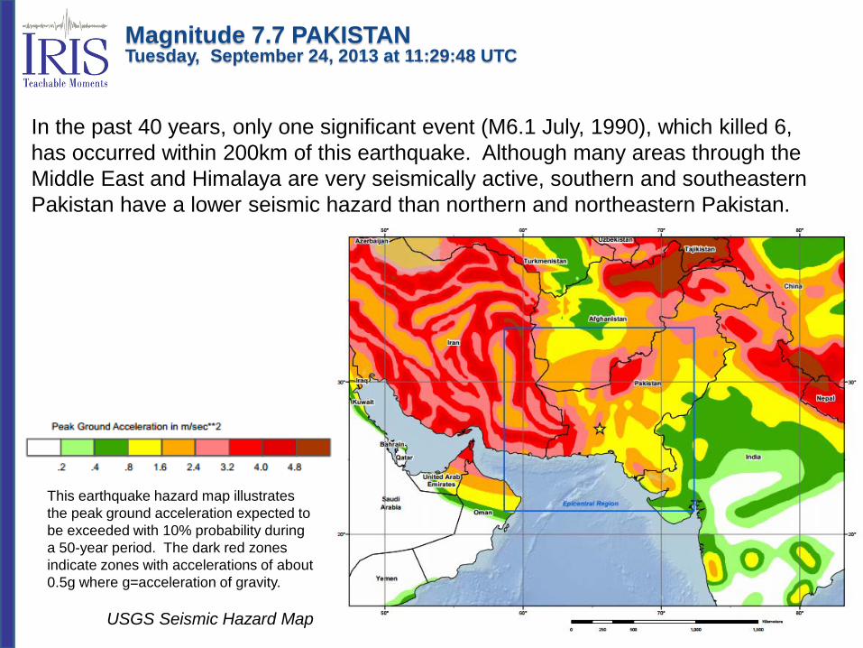
In the past 40 years, only one significant event (M6.1 July, 1990), which killed 6, has occurred within 200km of this earthquake. Although many areas through the Middle East and Himalaya are very seismically active, southern and southeastern Pakistan have a lower seismic hazard than northern and northeastern Pakistan.
USGS Seismic Hazard Map
Magnitude 7.7 PAKISTAN Tuesday, September 24, 2013 at 11:29:48 UTC
This earthquake hazard map illustrates the peak ground acceleration expected to be exceeded with 10% probability during a 50-year period. The dark red zones indicate zones with accelerations of about 0.5g where g=acceleration of gravity.

Direct P and S waves cannot travel to stations at an epicentral distance Δ > 103° because of the large decrease in wave velocities across the boundary between the mantle and the liquid outer core. There is a "shadow zone" for direct P waves in the range 103° < Δ < 140°. The S-wave shadow zone exists for Δ > 103° because the liquid outer core blocks S waves that cannot travel through liquids.
The record of the earthquake on the University of Portland seismometer (UPOR) is illustrated below. Portland is about 11,733 km (~7290 miles, 105.7 degrees) from the location of this earthquake.
Magnitude 7.7 PAKISTAN Tuesday, September 24, 2013 at 11:29:48 UTC

Animation explaining the seismic shadow zone. Epicentral distance is the angle formed by the intersection of the line from the earthquake to Earth's center with the line from the observing point to the Earth's center. S waves are seen up to a distance of 104° from an earthquake, but direct S waves are not recorded beyond this distance. P waves also have a shadow zone between 104° and 140°.
Jenda Johnson http://www.iris.edu/hq/programs/education_and_outreach/animations/18
Magnitude 7.7 PAKISTAN Tuesday, September 24, 2013 at 11:29:48 UTC

Teachable Moments are a service of
IRIS Education & Public Outreach and
The University of Portland
Magnitude 7.7 PAKISTAN Tuesday, September 24, 2013 at 11:29:48 UTC