magmatic and tectonic evolution of the caetano caldera ... · magmatic and tectonic evolution of...
TRANSCRIPT
For permission to copy, contact [email protected]© 2008 Geological Society of America
Magmatic and tectonic evolution of the Caetano caldera,north-central Nevada: A tilted, mid-Tertiary eruptive center and
source of the Caetano Tuff
David A. JohnU.S. Geological Survey, 345 Middlefi eld Road, Menlo Park, California 94025, USA
Christopher D. HenryNevada Bureau of Mines and Geology, University of Nevada, Reno, Nevada 89557, USA
Joseph P. ColganU.S. Geological Survey, 345 Middlefi eld Road, Menlo Park, California 94025, USA
75
Geosphere; February 2008; v. 4; no. 1; p. 75–106; doi: 10.1130/GES00116.1; 20 fi gures; 1 plate, 2 tables, 3 appendices.
ABSTRACT
The Caetano Tuff is a late Eocene, rhyo-lite ash-fl ow tuff that crops out within an ~90-km-long, east-west–trending belt in north-central Nevada, previously interpreted as an elongate graben or “volcano-tectonic trough.” New fi eld, petrographic, geochemi-cal, and geochronologic data show that: (1) the east half of the “trough” is actually the Caetano caldera, formed by eruption of the Caetano Tuff at 33.8 Ma and later structur-ally dismembered during Miocene extension; (2) the west half of the trough includes both the distinctly younger and unrelated Fish Creek Mountains caldera (ca. 24.7 Ma) and a west-trending paleovalley partly fi lled with outfl ow Caetano Tuff; and (3) the Caetano Tuff as previously defi ned actually consists of three distinct units, two units of the 33.8 Ma Caetano Tuff and an older (34.2 Ma) tuff, exposed north of the Caetano caldera, herein named the tuff of Cove Mine.
Miocene extensional faulting and tilt-ing has exposed the Caetano caldera over a paleodepth range of >5 km, from the cal-dera fl oor through post-caldera sedimentary rocks, providing exceptional constraints on an evolutionary model of the caldera that are rarely available for other calderas. The Caetano caldera fi lled with more than 4 km of intracaldera Caetano Tuff, while outfl ow tuff fl owed west and south of the caldera, primarily down Eocene paleovalleys. Cal-dera fi ll consists of two units of Caetano Tuff. The lower compound cooling unit is as much as 3600 m thick and is separated by a com-plete cooling break from a 500–1000-m-thick upper unit that consists of multiple, thin, ash
fl ows interbedded with sedimentary deposits. Multiple granite porphyries, including the 25-km2 Carico Lake pluton, intruded and domed the center of the caldera within 0.1 Ma of caldera formation; one of these por-phyries is associated with pervasive argil-lic and advanced argillic alteration of the western half of the caldera. All exposed cal-dera-related rocks are rhyolites or granites (71–77.5 wt% SiO2). Caldera collapse was signifi cantly greater than the thickness of caldera fi ll and created a topographic depres-sion that served as a depocenter until at least 25 Ma, fi lling with nearly 1 km of sediments and distally derived, ash-fl ow tuffs.
The caldera is presently exposed in a series of 40–50°, east-tilted blocks bounded by north-striking, west-dipping normal faults that formed after 16 Ma. Slip on these faults accommodated ~100% E-W extension, mak-ing the restored Caetano caldera ~20 km east-west by 10–18 km north-south. The esti-mated volume of intracaldera Caetano Tuff is, therefore, ~840 km3, and the minimum estimated total eruptive volume is ~1100 km3. Although the Caetano magmatic system was probably too young to supply heat for nearby Carlin-type gold deposits in the Cor-tez district, earlier nearby magmatic activity may have contributed to formation of these deposits. Reconstruction of the late Eocene, pre-Caetano caldera geologic setting, imme-diately prior to caldera formation, indicates that the Cortez Hills and Horse Canyon Car-lin-type deposits formed at ≤1 km depths.
Keywords: calderas, ash-fl ow tuff, magma re-surgence, Basin and Range Province, extension-al tectonics, Carlin-type gold deposit.
INTRODUCTION
The Caetano Tuff in north-central Nevada is one of the volumetrically largest manifesta-tions of vigorous mid-Tertiary (ca. 43–19 Ma) magmatism dominated by voluminous caldera-forming ash fl ow eruptions (Lipman et al., 1972; Best et al., 1989; Christiansen and Yeats, 1992). Carlin-type gold deposits in northern Nevada, which are among the largest gold deposits in the world and help make Nevada the second largest gold producer in the world (Price and Meeuwig, 2006), formed during this magmatism between 42 and 30 Ma (Hofstra et al., 1999; Fig. 1). Widespread tuffs that issued from the calderas can be dated with great precision, and, together with younger volcanic and sedimentary rocks, they provide key markers for determining the timing and magnitude of magmatism and exten-sion relative to the formation of Carlin-type gold deposits (e.g., Cline et al., 2005). The Caetano Tuff is a regionally widespread, late Eocene, ash-fl ow tuff in north-central Nevada (Fig. 1; Masursky, 1960; Gilluly and Masursky, 1965; Stewart and McKee, 1977). It is the only exten-sive, mid-Tertiary volcanic unit between the Tuscarora Mountains, ~120 km to the north of exposures of the Caetano Tuff (Castor et al., 2003; Henry, 2008), and the vast expanse of Oligocene and Miocene calderas >75 km to the south (Fig. 1; Best et al., 1989; Ludington et al., 1996). The Caetano Tuff and related rocks thus offer one of the few windows into the history of Cenozoic magmatism, extension, and ore deposit formation in the adjacent Battle Moun-tain-Eureka trend, which boasts several world-class, Carlin-type gold deposits.
The Caetano Tuff mostly occupies a west-trending belt ~40 km long by 10–18 km wide

John et al.
76 Geosphere, February 2008
43-19 Ma Volcanic rocksCenozoic intrusionsPre-Cenozoic rocksKnown and inferred calderasVolcano-tectonic troughs
Explanation
?
??
?
?
??
?
Caetanocaldera
25 0 25 50 75 100 kilometers
F
TR
B
BMT
T
CW
TM
C
S
SC CA
D
120° 118° 116° 114°
Figure 2
N
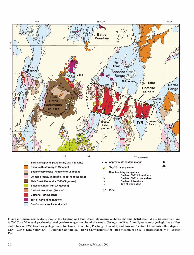
Figure 1. Map showing mid-Cenozoic (43–19 Ma) volcanic rocks and intrusions in northern Nevada and calderas (modifi ed from Ludington et al. [1996]) and volcano-tectonic troughs of Burke and McKee (1979). Box shows outline of Figure 2. B—Battle Mountain; BM—Bald Moun-tain; C—Cortez Range; CA—Clan Alpine Range calderas; CW—Cowboys Rest; D—Desatoya Mountains calderas; F—Fish Creek Moun-tains caldera; S—Shoshone Range; SC—Stillwater caldera complex; T—Toiyabe Range; TM—Tuscarora volcanic fi eld; TR—Tobin Range.
Magmatic and Tectonic Evolution of the Caetano caldera
Geosphere, February 2008 77
that has been described as the eastern half of a fault-bounded, volcano-tectonic trough (Masursky, 1960). As originally defi ned, the trough was inferred to extend ~90 km west from Grass Valley on the west side of the Cor-tez Range to Pleasant Valley on the west side of the Tobin Range (Figs. 1 and 2; Burke and McKee, 1979). This inferred structural control on the distribution of the tuff implied a late Eocene to early Oligocene episode of north-south extension not recognized elsewhere in the northern Great Basin. We interpret these rela-tions as two middle-Tertiary calderas modifi ed by Miocene Basin and Range extension. The thickest exposures(>3.4 km) of the Caetano Tuff are in the northern Toiyabe Range a few kilometers southwest of the Cortez and Cortez Hills Carlin-type gold deposits and ~10 km south of the Pipeline and Gold Acres Carlin-type gold deposits (Fig. 2). Rhyolite dikes of similar composition but slightly older age than the Caetano Tuff are exposed in the Cortez Mine, where they have been variably inter-preted to both pre-date and post-date formation of Carlin-type ores (Wells et al., 1969; Rytuba, 1985; McCormack and Hays, 1996; Mortensen et al., 2000).
New fi eld, petrographic, geochemical, and geochronologic data for the Caetano Tuff and related intrusive rocks are presented in this paper and in a companion paper (Colgan et al., 2008) that bear on the origin and source of the Caetano Tuff and the tectonic evolution of the surrounding area, including post-ore (<34 Ma) deformation of major nearby Carlin-type gold deposits. We have remapped the caldera, including caldera margins, the caldera fl oor, resurgent intrusions, and intracaldera stratig-raphy (Plate 1). These data show that tuffs previously correlated with Caetano Tuff con-sist of two distinct, ash-fl ow tuff units erupted ca. 400 ka apart: (1) the tuff of Cove Mine, a slightly older and more mafi c outfl ow tuff that mostly crops out north of the Caetano caldera and erupted from an unidentifi ed source, and (2) multiple cooling units of Caetano Tuff that fi ll the highly extended, structurally dismem-bered Caetano caldera and fl owed primarily south and west of the caldera (Fig. 2). Recon-struction of the Caetano caldera provides a strain marker for constraining later extension, and the companion paper (Colgan et al., 2008) uses the reconstructed caldera to document Late Cenozoic extension and the regional implications of this extension on adjacent Car-lin-type gold deposits.
METHODS OF STUDY
Major objectives of this study included (1) distinguishing between caldera versus volcano-tectonic trough origins for the “Caetano trough”; (2) in the case of a caldera origin, determining the timing and duration of ash-fl ow eruption, cal-dera collapse, and resurgent doming; (3) deter-mining whether previously mapped “Caetano Tuff” (including intracaldera and outfl ow tuff) is all the same tuff; and (4) constraining the tim-ing of post-caldera events, including the timing of major E-W extension. To accomplish these objectives, we compiled a 1:100,000-scale geologic map of the caldera (Plate 1), based on new geologic mapping of key localities at 1:24,000 scale, and we conducted petrographic, geochemical, and geochronologic analyses of samples collected throughout the caldera and surrounding region (Fig. 2; Appendices 1A, 1B, and 21).
To aid in correlation of the widely distributed tuffs, ~100 thin sections of previously mapped Caetano Tuff and related intrusive rocks were examined petrographically, and modal analyses were made for ~75 samples. Modally analyzed samples were divided into groups of intracal-dera Caetano Tuff, extracaldera Caetano Tuff, intrusive rocks, and the tuff of Cove Mine as described in the next section.
Seventy-two whole-rock samples of the Caetano Tuff, tuff of Cove Mine, and intrusive rocks in Carico Lake Valley were analyzed for major and trace elements by XRF (X-ray fl uorescence) techniques (Appendix 1A and 1B). Most tuff samples were devitrifi ed and densely welded, and we did not try to sepa-rate the strongly fl attened, crystal-rich pumice blobs. Our new chemical analyses were com-bined with ~25 previously published analy-ses in Roberts (1964), Gilluly and Masursky (1965), Stewart and McKee (1977), Doebrich (1995), Gonsior (2006), and M.G. Best (2004, written commun.). About 20% of all analyzed samples were strongly hydrothermally altered, as indicated by the presence of hydrothermal minerals (e.g., calcite or kaolinite) or by high SiO
2 or K
2O and/or low Na
2O contents; these
analyses were discarded. The remaining, rela-tively unaltered samples were divided into groups of intracaldera Caetano Tuff, extracal-dera Caetano Tuff, intrusive rocks, and the tuff of Cove Mine using the same divisions as for the modal data.
Published K-Ar dates from the Caetano Tuff range from 31.3 ± 0.6 to 35.3 ± 1.1 Ma (Sloan
et al., 2003) and are insuffi ciently precise to address major objectives of this study. Single crystal 40Ar/39Ar dating of sanidine provides highly precise, reproducible ages that can dis-tinguish volcanic events separated by as little as 100,000 yr at the ca. 34 Ma age of the Caetano Tuff(s) (Deino, 1989; McIntosh et al., 1990; Henry et al., 1997). Therefore, we determined 15 new, sanidine, single-crystal 40Ar/39Ar ages for previously mapped Caetano Tuff and a related pluton (Table 1). We also determined 40Ar/39Ar ages for intracaldera Fish Creek Mountains Tuff 15 km west of the Caetano caldera (Fig. 2) and for a tuff that resembles the Caetano Tuff from Bald Mountain 100 km to the east (Fig. 1). Analytical techniques and data are provided in Appendix 2.
GEOLOGY OF THE CAETANO CALDERA
Due to large magnitude (~100%) east-west extension along west-dipping normal faults in the middle Miocene (Colgan et al., 2008), the Caetano caldera is exceptionally well exposed in a series of east-tilted fault blocks. The entire stratigraphy of the caldera fi ll is exposed (Fig. 3), as well as a wide range of pre- and post-cal-dera rocks, thereby allowing a more complete understanding of caldera evolution than seen in most calderas. Numerous caldera-related struc-tural features are evident, including the caldera fl oor and margins, mesobreccias and megabrec-cias, resurgent intrusions, and post-collapse, caldera-fi lling sediments. This section empha-sizes caldera-related rocks but also briefl y sum-marizes pre- and post-caldera rocks. Detailed fi eld descriptions of caldera stratigraphy, struc-ture, and hydrothermal features are presented in subsequent sections.
Pre-Cenozoic Basement Rocks
Complexly deformed Paleozoic sedimentary rocks form the basement beneath the Caetano caldera. Lower Paleozoic siliciclastic rocks of the upper plate of the Roberts Mountains alloch-thon probably underlie most of the caldera. These rocks structurally overlie lower plate Neopro-terozoic-Devonian, carbonate-rich, continen-tal-shelf sedimentary rocks. The two sequences were superimposed along the Roberts Mountains thrust during the Late Devonian-Early Mississip-pian Antler orogeny (Roberts et al., 1958). The Roberts Mountains allochthon is overlain uncon-formably by Pennsylvanian-Permian clastic and
1If you are viewing the PDF of this paper or reading it offl ine, please visit http://dx.doi.org/10.1130/GES00116.S1, http://dx.doi.org/10.1130/GES00116.S2, and http://dx.doi.org/10.1130/GES00116.S3 or the full-text article on www.gsajournals.org to access Appendices 1A, 1B, and 2.
John et al.
78 Geosphere, February 2008
Figure 2. Generalized geologic map of the Caetano and Fish Creek Mountains calderas, showing distribution of the Caetano Tuff and tuff of Cove Mine and geochemical and geochronologic samples of this study. Geology modifi ed from digital county geologic maps (Hess and Johnson, 1997) based on geologic maps for Lander, Churchill, Pershing, Humboldt, and Eureka Counties. CH—Cortez Hills deposit; CLV—Carico Lake Valley; GC—Golconda Canyon; HC—Horse Canyon mine; RM—Red Mountain; TYR—Toiyabe Range; WP—Wilson Pass.
0 30 6015Kilometers
117°30'W 117°00'W 116°30'W
40°0
0'N
40°3
0'N
Mt.Lewis
GC
CLV
TYR
BattleMountain
Caetanocaldera
CaetanoRanch
CaricoLake
pluton
ShoshoneRange
TobinRange
FishCreek
Mountainscaldera
CortezRange
RM
WPPipeline
Gold Acres
CortezCH HC
Cove
Surficial deposits (Quaternary and Pliocene)
Basalts (Quaternary to Miocene)
Sedimentary rocks (Pliocene to Oligocene)
Volcanic rocks, undivided (Miocene to Eocene)
Fish Creek Mountains Tuff (Oligocene)
Bates Mountain Tuff (Oligocene)
Carico Lake pluton (Eocene)
Caetano Tuff (Eocene)
Tuff of Cove Mine (Eocene)
Pre-Cenozoic rocks, undivided
40Ar/39Ar sample site
Geochemistry sample site Caetano Tuff, intracaldera Caetano Tuff, extracaldera Caetano intrusions Tuff of Cove Mine
Mine
Approximate caldera margin N
Magmatic and Tectonic Evolution of the Caetano caldera
Geosphere, February 2008 79
carbonate rocks of the Antler overlap sequence (Roberts, 1964), which is exposed locally along the south margin of the caldera in the Shoshone Range (Plate 1; Moore et al., 2000) and underlies the caldera fl oor near Caetano Ranch in the Toi-yabe Range (Fig. 4A). The Late Jurassic (ca. 158 Ma) granodioritic Mill Canyon stock intrudes the Paleozoic rocks in the Cortez Range just east of the caldera (Plate 1).
Cenozoic Pre-Caetano Tuff Rocks
Few Cenozoic rocks predating the Caetano Tuff are exposed in the vicinity of the Caetano caldera. Gravel deposits overlie Paleozoic base-
ment on both the east and west ends of the caldera and locally form the caldera fl oor in the northern Toiyabe Range (Plate 1; Fig. 4B). These gravels are thought to fi ll a west-trend-ing paleovalley now largely obscured by the Caetano caldera; evidence for this interpretation is discussed in a later section. Andesite or dacite lava fl ows are present locally between the grav-els and the Caetano Tuff in the northern Toiyabe Range, and thin andesite or basalt fl ows underlie the caldera southwest of Wilson Pass in the Sho-shone Range. Andesite fl ows interbedded with tuffaceous sedimentary rocks underlie outfl ow Caetano Tuff on the east side of the Fish Creek Mountains just west of the caldera (Fig. 2).
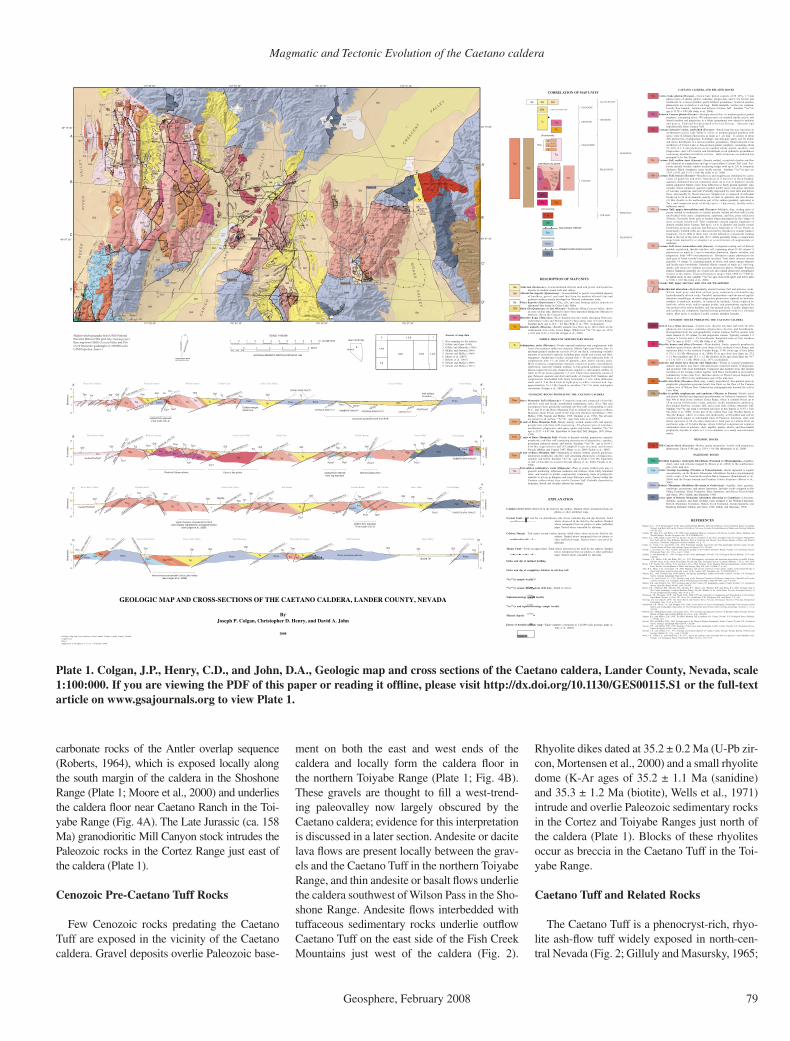
Plate 1. Colgan, J.P., Henry, C.D., and John, D.A., Geologic map and cross sections of the Caetano caldera, Lander County, Nevada, scale 1:100:000. If you are viewing the PDF of this paper or reading it offl ine, please visit http://dx.doi.org/10.1130/GES00115.S1 or the full-text article on www.gsajournals.org to view Plate 1.
Rhyolite dikes dated at 35.2 ± 0.2 Ma (U-Pb zir-con, Mortensen et al., 2000) and a small rhyolite dome (K-Ar ages of 35.2 ± 1.1 Ma (sanidine) and 35.3 ± 1.2 Ma (biotite), Wells et al., 1971) intrude and overlie Paleozoic sedimentary rocks in the Cortez and Toiyabe Ranges just north of the caldera (Plate 1). Blocks of these rhyolites occur as breccia in the Caetano Tuff in the Toi-yabe Range.
Caetano Tuff and Related Rocks
The Caetano Tuff is a phenocryst-rich, rhyo-lite ash-fl ow tuff widely exposed in north-cen-tral Nevada (Fig. 2; Gilluly and Masursky, 1965;
xRedMountain
x MountCaetano
x MountTenabo
x HorseMountain
x ElephantHead
Sto
ne
Cab
in
B
asin
G R
A S
S V
A L L E
Y
C R E
S C
E N
T
V A L L E Y
WilsonPass
Wood Spring Canyon
x BaldMountain
RockyPass
Wilso
n
R
E E
S E
R I
V E
R
V A
L L
E Y
C A
R I
C O
L A
K E
V A
L L
E Y
CaricoLake
Tub Spring
WenbanSpring
xCaetanoRanch
Figure 12
Figure 18
Figure 15
Figure 19
Figure 14
ELE
PH
AN
T
HEA
D
F
AULT
THE
C
ED
AR
S
FAU
LT
RED
RO
CK
C
AN
YO
N
FA
ULT
Qal
Qaf
Qaf
Qaf
Qaf
Tcl
Qaf Qal
Pzrm
Qaf
Qaf
Qaf
Pzrm
Tog
Tcc
Tcu Qaf
Ts
Pzlc
Ts
Qal
Tcu
Pzrm
Pzrm
Ts
Jgr
Qaf
Qaf
Pzo
Ts
Qaf
Tcl
Pzrm Pzrm
Qal
Qaf
Ts
Tcc
Tcl
Tad
Pzrm
Tcs
Tcs?
Pzrm
Qp
Pzlc
Ts
Pzrm
Qaf
Tcl
Qaf
Tcu
Tcl
Tcl
Tcs
Tcs
Tb
Pzrm
Tbm
Tcic
Ts?
Tcs
Tcu
Pzrm
Pzrm
Tcu
Pzlc
Tcc
Tcu
Tad
Pzrm
Tct
Qaf
Tcic
Tcl
Tcs
Qaf
Tcs
Tcl
Tbm
Tcs
Tbm
Tcu
Pzrm
Tcl
Pzlc
Tbm
Tbm?
Tcu
Ts?
Tcl
Tcb
Ts
Pzlc
Tad
Ts
Tbm
Tcu
Tci
Tbm?
Tcb
Tbm
Tog
Tcu
Pzlc
Tcl
Tct
Tbm
Pzo
Tct
Qp
Tct
Tbm
Tcu
Tcic
Tbm
Tad
Tbm
Qal
Tad?
Tad
Tbm
Tcu
Tad
Tog?
Tbm
Tad
Pzh
Tbm
Tad
Tad
Tog
Tcu
Pzh
Tad
Tad
Pzrm
Tct?
Tct
Tcs
Tct
Tcic
Tcic
Pzrm
Tbm?
Tct
Tcic
PzrmPzo
Tcs
Pzrm
Tct?
Tob
Qaf
Ts?Cortez
Pipeline pitsand dumps (2006)
Greystonemine
Tad
40
TOIY
AB
E
MIN
E
F
AU
LT
C
OR
TE
Z
FA
ULT
MO
SS
CR
EE
K
F
AU
LT
S
TO
NE
C
AB
IN
F
AU
LT
Pzrm
MILL CANYON STOCK
Tad
Toiyabe
PzoTcl
Tbm?
Tcs
Qal
Tcic
Tcc
Tbm?
Tcs
Qaf
Qaf
Tcs?
Tcs
DR
Y
CA
NYON
FAULT
MO
SS
CR
EE
k
FA
ULT
G
RE
YS
TO
NE
F
AU
LT ?
Tcu
60
Barite pit
GoldAcres
Ts
Tcl
CA
ETA
NO
RA
NC
H
F
AU
LT
WENBAN FAULT
Tcir
Tcb
CR
ES
CENT
F
AULT
RED
MOU
NTA
IN
FAU
LT
Tmr
Tor
Tor
Tcu?
Tcm
Tcu
TcuTcl
Tad
Tcu
s s
s s
s s
s s
s s
s s
s
s s
R E
D R
O C
K C
A N
Y O
N
s
s s s s s
s s s
s s
s s
s
Tad
Tad
TctTad
Tbm
RO
CK
Y
P
AS
S
F
AULT
GR
EY
ST
ON
E
F
AU
LT
Qaf
?
?
Tcb
Tcl
Ts
Ts
Ts
Ts
Pzrm
Tcs
Qaf
Tcl
Qal27
Tbm
Tor
Tcb
60Qal
35
Qaf
Qaf
CJV2
Qaf
l l l l l l l l l l l l
l l l l
l ll
l l
l l l l
Tci
TbmTcir
Tcir
TclTcu
Tbm
l l l l l l l l
l l
l l
Ts
l l
l l l l
l l l l l l
Tcir
Tbm
Tcir
l l
l l
l l
l
l
l
l
l ll
l l
l l l l l l
l l
l l
l l l l
Qaf
Tcl
Tcl
QafQaf
Tcu
Tcu
Tcc
Tcc
ll ll l l l l l l ll l l l l l l l
l l
ll l
l l
l l
ll l
l l
l l
l l
l l
l
l
l l
l l
l
l
ll l
l l
l l
l l
l l
l l
?
Tad
Tct
Cortez
CortezHills
Pediment HorseCanyon
D’
C’
B’
A’3
2
1
0
A
kilo
met
ers
3
2
1
0
B
kilo
met
ers
3
2
1
0
C
kilo
met
ers
3
2
1
0
D
kilo
met
ers
3
2
1
0
kilometers
3
2
1
0
kilometers
kilometers
3
2
1
0
kilometers
3
2
1
0
?
Ts
Tbm
Tcs
Tbm
Tcl
TbmTbm
Redrock Canyon
REDROCK CYN F
LT
THE CEDARS FLT?
Tcs Ts
Tad
MO
SS
C
RE
EK
FLT
THE CEDARS FLT?
Redrock Canyon
Caldera marginfaulted out
Pzrm
Tcl
Tcc TclTcs
Tcc?
TcsTad
Reese River Valley
Reese River Valley Wilson Canyon
GREYSTONE FLT
Cooks Creek Carico Lake Valley
Ts? Pzrm
Ts
TOIYBALE MINE FLT? ROBERTS THRUST? CAETANO RANCH FLT?
Pzrm?Pzlc?Pzrm QTs
Pzlc/Pzrm?
Pzrm
Crescent Valley Cortez Range
CRESCENT FLT
CORTEZ FLT?
fault obliqueto section
Tog
Tcc
Tcs
faulted Tcs/Tad?Tcc?
TcuTs
Tcir? Tcu
Tob?
Pzrm?
Tcic Tcic?
Ts
Tcl
Rocky PassCarico Lake Valley
ROCKY PASS FLT
GREYSTONE FLT?
Tcc
Redrock Canyon pluton Carico Lake pluton
TclTclTclTOIYABE MINE FLT
TcuTs
Tog
Pzrm?
Ts
Pzlc
Tcl
Grass ValleyToiyabe Range
CORTEZ FLT
CR
ESC
ENT
FLT
Pzrm?
Pzrm Tmr
Tb
Cortez Range
Grass Valley Cortez Range
ROBERTS MTN THRUST
faulted Tcs/Tad?
Reese River Valley Elephant Head
Tcc
THE CEDARS
FLT
Tcc
Tcs
MO
SS C
RE
EK
FLT
? Tbm
Tcl
STO
NE
CA
BIN
FLT
Tbm
Tcc
Ts?
Carico Lake Valley Tub Spring
ROCKY PASS FLT?
GREYSTONE FLT?
Tcu
Tcl
Caetano Ranch Mt. Caetano
TclTcl
Ts
CAETANO RANCH FLT
TOIYABE MINE FLT
Tcl
Tcu
Pzo? Tad?
Tad
PzoPzrm?
Tcl TogPzlc Pzrm
ROBERTS MTN THRUST
Ts?
Pzrm
Pzlc?
caldera floor exposed2 km north of A–A’
caldera floor exposed?1 km south of D–D’
structures projected north from B–B’
Pzrm; structure unknown
Grass Valley Cortez Range
Buried Ts?
Bald Mountain
Tog
Pzrm
CORTEZ FLT
TOIYABE MINE FLT
Ts Ts
Tbm
TctPzrm
Wood Spring CanyonRed Mountain
DRY CANYON FLT
Pzo?Pzrm
Ts?
Carico Lake Valley
Pzrm
STO
NE
CA
BIN
FLT
THE CEDARS F
LT
Inferred structure beneath Carico Lake Valley(see Colgan et al., 2008)
PzoTad
Pzrm
Pzh
Tad
The Cedars
MO
SS
CR
EE
K F
LT
Tcu
Pzlc?
s s
Pzlc?
Upper Caetano considered too thickand probably repreated by unmapped fault(s)
(see Colgan et al., 2008)
Tcl
Tog?
QafQafQaf
Qaf
Qaf
caldera floor inferredfrom Tog exposure
inferred caldera floor
Qaf Qal/Qp
QafQaf
QafQafQaf Qal
Qaf Qal
ELEPHANT HEAD FLT
QafQafQafQafQaf
Qaf
Qaf
ROCKY PASS FAULT?
MO
SS
C
REE
K F
LT
Tcu s
s
Tog
Tcb
s s s
Tad?/Tct?Tct
Tct
CORTEZ FLT
Tbm
Tcir
Tcir?
Tcir?
?Tbm?
Tcic?
Tcl
REDROCK CYN FLTTcu
Tcm?
TclTcu
Tcu
Stone Cabiin Basin
Tcu?
Qaf Qaf
Qaf
Tcs
Qal
CT107
CT108
CT116
H05-62
CT101CT102
CT121
CT120
00DJ34
H03-84
H03-82
H03-96
99DJ80
H03-94
06DJ13
H03-88B
H03-89
05DJ27
05DJ27
DC99-15334m
8
6
6
7
95
9
25
20
15
15
25
20
20
30
35
40
30
25
15
25
35
30
30
30
45
50
3545
45
55
50
32
25
25
60
50
40
40
37
48
29
40
27
2820
3723
20
30
40
53
62
11
21
12
3744
45 4343
90
2842
52
12
40
40
452550
3452
72
46
30
6035
35
35
35
40
20
45
40
605025
10
30
5020
25
15
6020
25
40
2535
2530
45
40
45
25
25
40
3545
40
30
30
5025
40
3545
4040
7572
25
10
30
45
40
45
40
52
4050
15
30
80
30
40
18
49
5145
28
50
30
3450
50
62
40
44
67
40
30
46
50
60
3032
44
35
3945
24
30
43
70
48
2328
46
35
3740
16
3050
60
7080
47
3575
4035
3729
26
85
30
75
46
42
33
70
3533 37
2534
10
20
43
30
55
48
45
41
55
4245
40
33
66
40
23
37
39
50
50
77
70
77
25
45
26
26
30
22
40
30
35
13
21
31
36
24
46
65
68
47
41
6144
64
31
2120 47
62
69
6480
38
38
41
42
63
21
40
37
87 73
37
37
47
116º 37’ 30”116º 45’ 00”116º 52’ 30”117º 00’ 00”
40º 07’ 30”
40º 15’ 00” 40º 15’ 00”
40º 07’ 30”
116º 37’ 30”116º 45’ 00”116º 52’ 30”117º 00’ 00”
SCALE 1:100,000
01 1 2 3 4 5 6 7 8 9 10 KILOMETERS
0 543211 MILES
15°
TR
UE
NO
RT
H
MA
GN
ET
IC N
OR
TH
APPROXIMATE MEANDECLINATION, 2000
GEOLOGIC MAP AND CROSS-SECTIONS OF THE CAETANO CALDERA, LANDER COUNTY, NEVADA
ByJoseph P. Colgan, Christopher D. Henry, and David A. John
2008
Sources of map data
1. New mapping by the authors.2. Gilluly and Gates (1965)3. Gilluly and Masursky (1965)4. McKee and Stewart (1969)5. Stewart and McKee (1969)6. Moore et al. (2007)7. Roberts et al. (1967)8. Stewart and McKee (1969)9. Stewart and McKee (1977)
1,8,9
1,6
1,3,9 1,3,7
1,2,9 72
1,4,9
NATIONAL GEODETIC VERTICAL DATUM OF 1983
Shaded-relief topography from USGS National Elevation Dataset (30m grid; http://ned.usgs.gov).Base map from USGS Crescent Valley and Fish Creek Mountains quadrangles (1:100,000 scale).UTM Projection, Zone 11
MAP LOCATION
NEVADA
A
B
C
D
C’
D’
B’
A’
Contact—Solid where observed in the field by the authors. Dashed where interpreted from air photos or other published maps.
Normal Fault—Ball and bar on downthrown side. Arrow indicates dip and dip direction. Solid where observed in the field by the authors. Dashed where interpreted from air photos or other published maps. Dotted where concealed by alluvium.
Caldera Margin—Tick marks toward caldera interior. Solid where observed in the field by the authors. Dashed where interpreted from air photos or other published maps. Dotted where concealed by alluvium.
Thrust Fault—Teeth on upper plate. Solid where observed in the field by the authors. Dashed where interpreted from air photos or other published maps. Dotted where concealed by alluvium.
Strike and dip of inclined bedding
Strike and dip of compaction foliation in ash-flow tuff
40Ar/39Ar sample locality
40Ar/39Ar sample locality from drill hole—Depth in meters.
Tephrachronology sample locality
40Ar/39Ar and tephrachronology sample locality
Mineral deposit
Extent of detailed geologic map—Figure numbers correspond to 1:24,000-scale geologic maps in John et al. (2008).
EXPLANATION
REFERENCES
Bingler, E.C., 1978, Abandonment of the name Hartford Hill Rhyolite Tuff and adoption of new formation names for middle Tertiary ash-flow tuffs in the Carson City-Silver City area, Nevada: Nevada Bureau of Mines and Geology Bulletin 1457-D, 19 p.
Colgan, J.P., John, D.A., and Henry, C.D., 2008, Large-magnitude Miocene extension of the Eocene Caetano caldera, Shoshone and Toiyabe Ranges, Nevada: Geosphere, doi: 10.1130/GES00115.1.
Deino, A.L., 1989, Single crystal 40Ar/39Ar dating as an aid in correlation of ash flows: Examples from the Chimney Springs/New Pass Tuffs and the Nine Hill/Bates Mountain Tuffs of California and Nevada: New Mexico Bureau of Mines and Mineral Resources, Continental Magmatism Abstracts Bulletin 131, p. 70.
Faulds, J.E., Henry, C.D., and dePolo, C.M., 2003, Preliminary geologic map of the Tule Peak Quadrangle, Washoe County, Nevada: Nevada Bureau of Mines and Geology Open-File Report 03-10, 1:24,000.
Gilluly, J., and Gates, O., 1965, Tectonic and igneous geology of the northern Shoshone Range, Nevada: U.S. Geological Survey Professional Paper 465, 153 p., scale 1:31,680.
Gilluly, J., and Masursky, H., 1965, Geology of the Cortez quadrangle, Nevada: U.S. Geological Survey Bulletin 1175, scale 1:62,500.
Gromme, C.S., McKee, E.H., and Blake, M.C., Jr., 1972, Paleomagnetic correlations and potassium-argon dating of middle Tertiary ash-flow sheets in the eastern Great Basin, Nevada and Utah: Geological Society of America Bulletin, v. 83, p. 1619–1638.
Henry, C.D., Faulds, J.E., dePolo, C.M., and Davis, D.A., 2004, Geology of the Dogskin Mountain Quadrangle, northern Walker Lane, Nevada: Nevada Bureau of Mines and Geology Map 148, scale 1:24,000, 13 p. text.
John, D.A., Henry, C.D., and Colgan, J.P., 2008, Magmatic and tectonic evolution of the Caetano caldera, north-central Nevada: A tilted mid-Tertiary eruptive center and source of the Caetano Tuff: Geosphere, doi: 10.1130/GES00116.1.
McKee, E.H., 1968, Geologic map of the Spencer Hot Springs Quadrangle, Lander and Eureka Counties, Nevada: U.S. Geological Survey Geologic Quadrangle Map GQ-770.
McKee, E.H., and Conrad, J.E., 1987, Geologic map of the Desatoya Mountains Wilderness Study Area, Churchill and Lander counties, Nevada: U.S. Geological Survey Miscellaneous Field Studies Map MF-1944, scale 1:62,500.
McKee, E.H., and Stewart, J.H., 1969, Geologic map of The Cedars [15'] quadrangle, Lander County, Nevada: U.S. Geological Survey Open-File Report 69-268, scale 1:62,500.
Moore, T.E., O'Sullivan, P.B., Murchey, B.L., Moring, B.C., Harris, A.G., Blodgett, R.B., and Fleck, R.J., 2005, Geologic map of The Cedars quadrangle, southern Shoshone Range, Nevada: Window to the world: Reno, Nevada, Geological Society of Nevada Symposium Proceedings, May 14-18, p. 67.
Mortensen, J.K., Thompson, J.F.H., and Tosdal, R.M., 2000, U-Pb age constraints on magmatism and mineralization in the northern Great Basin, Nevada, in Cluer, J.K., Price, J.G., Struhsacker, E.M., Hardyman, R.F., and Morris, C.L., eds.,
Geology and ore deposits 2000: The Great Basin and beyond: Reno, Nevada, Geological Society of Nevada Symposium Proceedings, May 15-18, p. 419-438.
Racheboeuf, P.R., Moore, T.E., and Boldgett, R.B., 2004, A new species of Dyoros (brachiopoda, chonetoidea) from Nevada (United States) and stratigraphic implication for the Pennsylvanian and Permian Antler overlap assemblage: Geobios, v. 37, p. 382-394.
Roberts, R.J., Montgomery, K.M., and Lehner, R.E., 1967, Geology and mineral resources of Eureka County, Nevada: Nevada Bureau of Mines and Geology Bulletin 64, 164 p., scale 1:250,000.
Sargent, K.A., and McKee, E.H., 1969, The Bates Mountan Tuff in northern Nye County, Nevada: U.S. Geological Survey Bulletin, v. 1294-E, 12 p.
Stewart, J.H., and McKee, E.H., 1968, Geologic map of the Mount Callaghan Quadrangle, Lander County, Nevada: U.S. Geological Survey Geologic Quadrangle Map GQ-730, 1:62,500.
Stewart, J.H., and McKee, E.H., 1969, Geology of the Carico Lake quadrangle, Lander County, Nevada: U.S. Geological Survey Open-File Report 69-268, scale 1:62,500.
Stewart, J.H., and McKee, E.H., 1977, Geology and mineral deposits of Lander County, Nevada: Nevada Bureau of Mines and Geology Bulletin 88, 114 p., scale 1:250,000.
Wells, J.D., Elliott, J.E., and Obradovich, J.D., 1971, Age of the igneous rocks associated with ore deposits, Cortez-Buckhorn area, Nevada: U.S. Geological Survey Professional Paper 750-C, p. C127-C135.
CORRELATION OF MAP UNITS
Qal Qaf
Ts
Tad
Tog
Tob
Jgr
Pzh
Qp
QTs
Pzo
Pzrm
MIOCENE
PLIOCENE
OLIGOCENE
EOCENE
JURASSIC
NEOGENE
QUATERNARY
PALEOGENE
CENOZOIC
MESOZOIC
PALEOZOIC
Pzlc
GOLCONDA THRUST
ROBERTS MOUNTAIN THRUST
Tct
Tcs
cross-sections only
Tmr
Tb
Tcu
Tct
Tcb
Tcl
Tad
Tcm
Tor
Tog
Tob
Pzh
Jgr
Pzo
Pzrm
Pzlc
CAETANO CALDERA AND RELATED ROCKS
Carico Lake pluton (Eocene)—Carico Lake pluton consists of 50–60%, 1–5 mm phenocrysts of smoky quartz, sanidine, plagioclase and 2–3% biotite and hornblende in a microcrystalline quartz-feldspar groundmass. Scattered sanidine phenocrysts are as much as 2 cm long. Small miarolitic cavities are common. Locally flow banded. Intrudes and deforms Caetano Tuff. Sanidine 40Ar/39Ar age is 33.78 ± 0.05 Ma (John et al., 2008).
Redrock Canyon pluton (Eocene)—Strongly altered fine- to medium-grained granite porphyry containing about 30% phenocrysts of rounded smoky quartz and altered sanidine and plagioclase in a felsite groundmass now altered to kaolinite a n d q u a r t z . U n d a t e d b u t p r e s u m e d t o b e l a t e E o c e n e . I n t r u d e s a n d hydrothermally alters Caetano Tuff.
Caetano intrusive rocks, undivided (Eocene)—Small ring-fracture intrusion in northwestern Carico Lake Valley is a fine- to medium-grained porphyry with sparse white K-feldspar phenocrysts as much as 1 cm long. It consists of about 45% phenocrysts of plagioclase, K-feldspar, and dark-gray quartz and 3% biotite and sparse hornblende in a microcrystalline groundmass. Small intrusion 2 km northwest of Carico Lake is fine-grained granite porphyry containing about 25–30%, 0.1–3 mm phenocrysts of rounded smoky quartz, sanidine, and plagioclase, and 1-2% biotite and hornblende in an aphanitic groundmass containing abundant miarolitic cavities. Both intrusions are undated but presumed to be late Eocene.
Caetano Tuff, outflow sheet (Eocene)—Densely welded, crystal-rich rhyolite ash-flow tuff identical in composition and age to intracaldera Caetano Tuff (unit Tcc). Forms densely welded, reddish weathering ledges with up to 250 m composite thickness. Black vitrophyric zones locally present. Sanidine 40Ar/39Ar ages are 33.83 ± 0.05 and 33.75 ± 0.06 Ma (John et al., 2008).
Caetano Tuff, breccia (Eocene)—Mesobreccia and megabreccia dominated by coarse clasts of quartzi te and chert . Mesobreccia is massive to thick bedded, quartzite-dominated breccia containing clasts up to 2 m in diameter, mostly matrix supported. Matrix varies from tuffaceous to finely ground quartzite. Also includes matrix-supported, quartzite-argillite pebble layers and sparse interbeds of volcanic sandstone and tuff. Probably deposited by rock falls and debris flows, and possibly by fluvial processes. Megabreccia is composed of individual blocks up to 50 m in diameter, mostly of chert or quartzite, but also Eocene (35 Ma) rhyolite in the northeastern part of the caldera (probably equivalent to Tor), and composite areas of blocks up to ~1 km across, locally with a tuffaceous matrix.
Caetano Tuff, upper intracaldera unit (Eocene)—Multiple, thin, cooling units of poorly welded to moderately or (rarely) densely welded ash-flow tuffs locally interbedded with coarse conglomerate, sandstone, and fine, platy tuffaceous siltstone. Generally forms pale or banded slopes punctuated by thin ledges of more resistant welded tuff. Tuffs commonly contain angular fragments of densely welded lower Caetano Tuff up to 1.4 m in diameter and locally contain hornblende-pyroxene andesite and Paleozoic fragments to 15 cm. Poorly to moderately welded tuffs are characterized by distinctive orange pumice fragments. Up to 1000 m thick; base of unit defined as a prominent welding break at the top of the lower unit (Tcc), which generally forms a conspicuous slope break marked by a vitrophyre or several meters of conglomerate or sandstone.
Caetano Tuff, lower intracaldera unit (Eocene)—Compound cooling unit of densely welded, crystal-rich, rhyolite ash-flow tuff, containing about 35–50 volume % phenocrysts as much as 5 mm in maximum dimension. Quartz, sanidine, and plagioclase form >90% total phenocrysts. Distinctive quartz phenocrysts are dark gray to black (smoky) and partly resorbed. Total mafic mineral content generally <4 volume %, consisting mainly of biotite with minor opaque minerals and locally trace hornblende. Euhedral allanite crystals as much as 1 mm long, apatite, and zircon are common accessory phenocryst phases. Strongly flattened pumice fragments generally are crystal rich and contain phenocryst assemblages similar to the matrix. Exposed thickness ranges from 1800 to >3400 m. Weighted mean of nine sanidine 40Ar/39Ar ages from both upper and lower units is 33.80 ± 0.05 Ma (John et al., 2008).
Caetano Tuff, upper and lower units (Tcu and Tcl) undivided.
Hydrothermal alteration—Hydrothermally altered Caetano Tuff and intrusive rocks. W h i t e , d a r k - g r a y, a n d d a r k y e l l o w - g r a y, c o m m o n l y r e d w e a t h e r i n g hydrothermally altered rocks. Variable intermediate and advanced argillic alteration assemblages in which plagioclase phenocrysts replaced by kaolinite, sanidine is unaltered, perthitic, or replaced by kaolinite, biotite replaced by kaolinite, white mica, and/or opaque oxides, and groundmass replaced by fine-grained silica and/or kaolinite and fine-grained pyrite. Locally, plagioclase and sanidine are completely leached leaving prominent voids in a siliceous matrix. Most pyrite is oxidized. Locally contains abundant hematite.
CENOZOIC ROCKS PREDATING THE CAETANO CALDERA
Tuff of Cove Mine (Eocene)—Crystal-rich, rhyolite ash-flow tuff with 30–50% phenocrysts of quar tz , sanidine, p lagioclase , b iot i te , and hornblende. Distinguished from the petrographically similar Caetano Tuff by greater total mafic mineral (6–10 volume %) and plagioclase content. Typically contains 5–8 volume % biotite and 1–2% hornblende. Weighted mean of four sanidine 40Ar/39Ar ages is 34.22 ± 0.01 Ma (John et al., 2008).
Rhyolite domes and dikes (Eocene)—Flow-banded, finely, sparsely porphyritic sanidine-quartz-biotite rhyolite lava dome in the southern Cortez Range and numerous dikes in the northern Toiyabe Range. U-Pb zircon age of lava dome is 35.2 ± 0.2 Ma (Mortensen et al., 2000). K-Ar ages from lava dome are 35.2 ± 1.1 Ma (sanidine) and 35.3 ± 1.2 Ma (biotite); K-Ar ages from dikes are 34.7 ± 1.1 to 35.8 ± 1.2 Ma (Wells et al., 1971, recalculated).
Andesite and dacite lava (Eocene and Oligocene)—Finely to coarsely porphyritic andesite and dacite lava flows with phenocrysts comprised mostly of plagioclase and pyroxene with local hornblende. Composite unit includes lavas that predate formation of the Caetano caldera together with flows interbedded in post-caldera sedimentary rocks (unit Tcs). Includes dacite of Wood Canyon mapped by Moore et al. (2007) in the southwestern part of the map area.
Basaltic lava flows (Eocene)—Dark gray, weakly propylitized, fine-grained sparsely porphyritic plagioclase-pyroxene basalt lava flows on the floor of the Caetano caldera west of Wilson Pass. Undated but stratigraphically beneath the tuff of Cove Mine.
Boulder to pebble conglomerate and sandstone (Miocene to Eocene)—Poorly sorted and poorly lithified unit deposited unconformably on Paleozoic basement. More than 400 m thick in the southern Cortez Range, where it contains blocks up to 10 m across of Paleozoic rocks , grani t ic rocks , porphyri t ic andesi tes , flow-banded rhyolites, Caetano Tuff, and several units of Bates Mountain Tuff. Sanidine 40Ar/39Ar age from a reworked ash layer in this deposit is 33.97 ± 0.20 Ma (John et al., 2008). Forms part of the caldera floor near Wenban Spring in Toiyabe Range, where it is dark red, moderately well bedded and calcite cemented with angular to subrounded clasts of Paleozoic limestone, chert, and minor quartzite to 90 cm. Also inferred to form part of caldera floor on northwest edge of Toiyabe Range, where lithified conglomerate contains subrounded clasts of quartzite, chert, argillite, granite, diorite, and flow-banded porphyritic rhyolite as much as 1.5 m in diameter in a sandy non-calcareous matrix.
MESOZOIC ROCKS
Mill Canyon Stock (Jurassic)—Biotite quartz monzonite, locally with plagioclase phenocrysts. Zircon U-Pb age is 158.4 ± 0.6 Ma (Mortensen et al., 2000).
PALEOZOIC ROCKS
Havallah Sequence (Golconda Allochthon) (Permian to Mississippian)—Argillite, chert, sand, and siltstone mapped by Moore et al. (2005) in the southwestern part of the map area.
Antler Overlap Assemblage (Permian to Pennsylvanian)—Rocks deposited in angular unconformity on the Roberts Mountains Allochthon. Includes predominantly clastic rocks of the Permian Horseshoe Basin Sequence (Raucheboeuf et al., 2004) and the Pennsylvanian and Permian Cedars Sequence (Moore et al., 2005).
Roberts Mountains Allochthon (Devonian to Ordovician)—Argillite, chert, quartzite, sandstone, greenstone, and minor limestone. Includes rocks assigned to the Valmy Formation, Vinini Formation, Elder Sandstone, and Slaven Chert (Gilluly and Gates, 1965; Gilluly and Masursky, 1965).
Lower plate of Roberts Mountains Allochthon (Devonian to Cambrian)—Limestone, dolomite, quartzite, and shale. Includes rocks assigned to the Wenban Limestone, Roberts Mountains Formation, Hanson Creek Formation, Eureka Quartzite, and Hamburg Dolomite (Gilluly and Gates, 1965; Gilluly and Masursky, 1965).
Tcic
Tcir
Tci
Tor
Tcm
Tbm
Unconformity
Unconformity
Unconformity
s s
s s
Qal
Qaf
Qp
QTs
Tb
Tcs
Ts
DESCRIPTION OF MAP UNITS
Tbm
Tbm
Tbm
Tbm
Alluvium (Holocene)—Unconsolidated alluvial sand and gravel and lacustrine deposits in modern stream beds and valleys.
Alluvial-fan deposits (Quaternary)—Unconsolidated to poorly consolidated deposits of boulders, gravel, and sand that form the modern alluvial fans and pediment surfaces mostly developed on Miocene sedimentary rocks.
Playa deposits (Quaternary)—Clay, silt, and sand forming surface deposits in ephemeral lake basins in Carico Lake Valley
Basin fill (Quaternary to late Miocene)—Sediments filling Crescent Valley, shown in cross section only. Inferred to have been deposited during late Miocene to Holocene slip on the Crescent Fault.
Rhyolite dome (Miocene)—Flow-banded rhyolite dome intruding Paleozoic sedimentary rocks and Tertiary gravel (Tog) along crest of Cortez Range. Sanidine K-Ar age is 15.6 ± 0.4 Ma (Wells et al., 1971, recalculated).
Basaltic andesite (Miocene)—Basaltic andesite lava flows up to 100 m thick on the southeastern crest of the Cortez Range. Whole-rock 40Ar/39Ar ages are 16.36 ± 0.05 and 16.67 ± 0.14 Ma (Colgan et al., 2008).
MIDDLE MIOCENE SEDIMENTARY ROCKS
Sedimentary rocks (Miocene)—Poorly exposed sandstone and conglomerate with lesser finer-grained tuffaceous deposits. Mostly light gray-brown, fine- to medium-grained sandstone in beds 10–20 cm thick, containing variable amounts of pyroclastic material including glass shards and crystal and lithic fragments. Sandstones locally contain thin (~10 cm) lenticular beds of conglomerate with 1–5 cm clasts of quartzite, chert, and/or volcanic rocks. More extensive conglomerate deposits consist of poorly consolidated, light-brown, massively bedded, medium- to fine-grained sandstone containing matrix-supported (locally channelized), angular to subrounded cobbles as much as 50 cm across (generally 1–5 cm). Clasts most commonly consist of gray Paleozoic quartzite and chert and locally of Caetano Tuff. Sandstone and conglomerate interbedded with thinly laminated (<1 cm), white tuffaceous shale and 2–5 m thick beds of l ight gray to whi te volcanic ash. Age approximately 16–12 Ma, based on sanidine 40Ar/39Ar dates and tephra correlations (Colgan et al., 2008).
CENOZOIC ROCKS POSTDATING THE CAETANO CALDERA
Bates Mountain Tuff (Oligocene)—Composite map unit composed of rhyolite ash-flow tuffs and locally interbedded sedimentary rocks (Tcs). This unit encompasses three genetically unrelated ash-flow tuffs corresponding to units B, C, and D of the Bates Mountain Tuff as defined for exposures at Bates Mountain about 60 km south of the map area (Stewart and McKee, 1968; McKee, 1968; Sargent and McKee, 1969; Gromme et al., 1972). Not all units are present in all sections. 40Ar/39Ar ages from John et al. (2007).
D unit of Bates Mountain Tuff—Mostly densely welded, pumice-rich, and sparsely porphyr i t ic ash- f low tuff conta in ing ~5% phenocrys ts of san id ine , anorthoclase, plagioclase, and sparse quartz and biotite. Sanidine 40Ar/39Ar age is 25.27 ± 0.07 Ma. Equivalent to Nine Hill Tuff (Bingler, 1978; Deino, 1989).
C unit of Bates Mountain Tuff—Poorly to densely welded, pumiceous, sparsely porphyritic ash-flow tuff containing phenocrysts of plagioclase, sanidine, prominent embayed quartz, and biotite. Sanidine 40Ar/39Ar age is 28.64 ± 0.06 Ma. Equivalent to tuff of Campbell Creek in central and western Nevada (McKee and Conrad, 1987; Henry et al., 2004; Faulds et al., 2005).
B unit of Bates Mountain Tuff—Moderately to densely welded, sparsely pumiceous, moderately porphyritic ash-flow tuff containing phenocrysts of plagioclase, sanidine, and biotite. Sanidine 40Ar/39Ar age is 30.48 ± 0.07 Ma. Equivalent to tuff of Sutcliffe in western Nevada (Henry et al., 2004; Faulds et al., 2005).
Post-caldera sedimentary rocks (Oligocene)—Platy to poorly bedded, pale gray to greenish weathering, tuffaceous sandstone and siltstone, white finely laminated shale, and boulder to pebble conglomerate containing clasts of porphyritic andesite to 60 cm in diameter and some Paleozoic rocks. Present within the Caetano caldera where they overlie Caetano Tuff. Probably deposited in lacustrine, fluvial and (locally) alluvial fan settings.
7
33
00DJ34
s s s s
b
c
d
Tcc
Tmr
CT101
27
l l l l l l l l l l l l l l l l
CT107
DC99334m
Figure 12
Tcb
Tcl
Tcir
CAETANO CALDERA
Tcu
Tcic Tci
Geologic Map and Cross Sections of the Caetano Caldera, Lander County, NevadaColgan et al.Plate 1Supplement to Geosphere, v. 4, no. 1 (February 2008)

John et al.
80 Geosphere, February 2008
TA
BLE
1. S
AN
IDIN
E S
ING
LE-C
RY
ST
AL,
40A
r/39
Ar
AG
ES
, CA
ET
AN
O T
UF
F A
ND
OT
HE
R T
UF
FS
, CA
ET
AN
O C
ALD
ER
A A
RE
A
S
ampl
e no
. La
bora
tory
A
ge (
Ma)
±
2K
/Ca
±2
n M
SW
D
Latit
ude
Long
itude
R
efer
ence
C
aeta
no T
uff
Intr
acal
dera
tuff
Tilt
ed S
ectio
n, C
orte
z 15
' Qua
dran
gle,
Toi
yabe
Ran
ge
Hig
hest
exp
osed
00
-DJ-
34
New
Mex
ico
Tec
h 33
.79
0.08
78
.7
35.2
12
0.
71
40.1
5633
–1
16.6
2136
T
his
stud
y
Hig
hest
exp
osed
00
-DJ-
34
New
Mex
ico
Tec
h 33
.81
0.05
61
.1
35.5
14
1.
21
40.1
5633
–1
16.6
2136
T
his
stud
y
Mid
dle
H03
-82
New
Mex
ico
Tec
h 33
.82
0.05
69
.4
24.5
13
1.
22
40.1
5868
–1
16.6
6343
T
his
stud
y
Low
est e
xpos
ed
H03
-84
New
Mex
ico
Tec
h 33
.71
0.07
82
.9
32.6
10
1.
66
40.1
6440
–1
16.6
7692
T
his
stud
y
O
ther
intr
acal
dera
M
oss
Cre
ek C
anyo
n, u
pper
mos
t H
03-9
4 N
ew M
exic
o T
ech
33.7
40.
05
69.5
21
.1
14
0.39
40
.207
53
–117
.028
75
Thi
s st
udy
M
oss
Cre
ek C
anyo
n, lo
wer
mos
t 05
-DJ-
14
New
Mex
ico
Tec
h 33
.84
0.08
58
.9
27.1
10
1.
91
40.2
0856
–1
17.0
3818
T
his
stud
y
Sou
th o
f Roc
ky P
ass,
low
erm
ost
05-D
J-27
N
ew M
exic
o T
ech
33.8
50.
09
63.4
33
.4
10
1.85
40
.171
45
–116
.815
44
Thi
s st
udy
T
he C
edar
s Q
uadr
angl
e, S
hosh
one
Ran
ge
H03
-88B
N
ew M
exic
o T
ech
33.8
10.
08
82.5
29
.9
9 1.
63
40.1
1700
–1
17.0
3700
T
his
stud
y
C
aric
o La
ke In
trus
ion
H03
-96
New
Mex
ico
Tec
h 33
.78
0.05
55
.7
16.2
15
1.
02
40.1
6722
–1
16.8
4862
T
his
stud
y
Out
flow
tuff
rela
ted
to in
trac
alde
ra tu
ff
The
Ced
ars
Qua
dran
gle,
Sho
shon
e R
ange
H
03-8
9 N
ew M
exic
o T
ech
33.8
30.
05
58.7
25
.8
21
0.61
40
.096
63
–117
.057
63
Thi
s st
udy
Gol
cond
a C
anyo
n, T
obin
Ran
ge
Tru
5-4
New
Mex
ico
Tec
h 33
.75
0.06
10
0.
60
40.3
2450
–1
17.5
9367
G
onsi
or,
2006
; thi
s st
udy
R
ewor
ked
pyro
clas
tic-f
all t
uff
H
orse
Can
yon,
Cor
tez
Ran
ge
99-D
J-80
U
SG
S M
enlo
Par
k 33
.97
0.20
40
.131
81
–116
.522
64
Thi
s st
udy
T
uff o
f Cov
e M
ine
B
ase
of s
ectio
n, W
ilson
Pas
s 06
-DJ-
13
New
Mex
ico
Tec
h 34
.21
0.10
63
.8
16.6
7
1.99
40
.257
61
–116
.978
43
Thi
s st
udy
Ele
phan
t Hea
d, s
outh
of B
attle
Mou
ntai
n H
03-8
7 N
ew M
exic
o T
ech
34.2
10.
07
9 1.
30
40.6
0825
–1
16.9
8945
T
his
stud
y
N
orth
ern
Fis
h C
reek
Mou
ntai
ns
05-D
J-8
New
Mex
ico
Tec
h 34
.22
0.06
81
.2
14.0
9
1.29
40
.414
10
–117
.219
10
Thi
s st
udy
Mul
e C
anyo
n Q
uadr
angl
e, n
orth
ern
Sho
shon
e R
ange
H
00-5
3 N
ew M
exic
o T
ech
34.2
30.
09
62.0
12
.4
13
2.41
40
.569
40
–116
.708
49
Thi
s st
udy
Mul
e C
anyo
n Q
uadr
angl
e, n
orth
ern
Sho
shon
e R
ange
98
-DJ-
52
US
GS
Men
lo P
ark
34.4
50.
08
40.5
2222
–1
16.7
1694
Jo
hn e
t al
., 20
00
C
aeta
no-li
ke tu
ff
O
utflo
w tu
ff, B
ald
Mou
ntai
n H
03-1
08
New
Mex
ico
Tec
h 35
.10
0.06
52
44
.5
15
2.20
39
.931
07
–115
.588
70
Thi
s st
udy
R
ewor
ked
tuff,
Alli
gato
r R
idge
–
US
GS
Den
ver
35.2
20.
08
39.8
7333
–1
15.4
8333
N
utt,
2000
N
on-C
aeta
no tu
ffs
P
yroc
last
ic-f
all t
uff,
Pip
elin
e pi
t C
JV2
New
Mex
ico
Tec
h 15
.88
0.10
1.
6 1.
0 8
0.29
40
.249
77
–116
.721
57
Thi
s st
udy
F
ish
Cee
k M
ount
ains
Tuf
f H
03-7
3 N
ew M
exic
o T
ech
24.7
20.
05
21.0
6.
8 15
0.
56
40.1
8627
–1
17.2
4263
T
his
stud
y
Bat
es M
ount
ain
Tuf
fs a
t Ree
se R
iver
Nar
row
s an
d N
ew P
ass
D
Nin
e H
ill T
uff,
New
Pas
s H
00-7
8 N
ew M
exic
o T
ech
25.2
70.
07
9.4
2.5
15
39
.576
37
–117
.527
21
Thi
s st
udy
C
Tuf
f of C
ampb
ell C
reek
H
01-1
39
New
Mex
ico
Tec
h 28
.64
0.07
56
13
.4
10
39
.944
38
–117
.141
59
Thi
s st
udy
B
Tuf
f of S
utcl
iffe
H01
-138
N
ew M
exic
o T
ech
30.4
80.
06
32
4.3
15
39
.944
91
–117
.141
83
Thi
s st
udy
A
Tuf
f of R
attle
snak
e C
anyo
n H
01-1
37
New
Mex
ico
Tec
h 31
.03
0.07
38
4.
2 12
39.9
4438
–1
17.1
4296
T
his
stud
y N
ote:
Age
s in
bol
d ar
e be
st e
stim
ates
of e
rupt
ion
age.
n =
num
ber
of in
divi
dual
gra
ins
used
to d
efin
e w
eigh
ted-
mea
n ag
e. D
ecay
con
stan
ts a
nd is
otop
ic a
bund
ance
s af
ter
Ste
iger
and
Jäg
er
(197
7).
b = 4
.963
1
0–10 y
r–1.
e + e
= 0
.581
1
0–10 yr
–1.40
K/K
= 1
.167
× 1
0–4. M
iner
als
wer
e se
para
ted
from
cru
shed
, sie
ved
sam
ples
by
stan
dard
mag
netic
and
den
sity
tech
niqu
es;
sa
nidi
ne w
as le
ache
d w
ith d
ilute
HF
to r
emov
e m
atrix
and
han
dpic
ked.
Ana
lyse
s at
the
New
Mex
ico
Geo
chro
nolo
gica
l Res
earc
h La
bora
tory
(m
etho
ds in
McI
ntos
h et
al.,
200
3). S
ampl
es
wer
e irr
adia
ted
in A
l dis
cs fo
r 7
hour
s in
D-3
pos
ition
, Nuc
lear
Sci
ence
Cen
ter,
Col
lege
Sta
tion,
Tex
as. N
eutr
on fl
ux m
onito
r F
ish
Can
yon
Tuf
f san
idin
e (F
C-1
). A
ssig
ned
age
= 2
8.02
M
a (R
enne
et a
l., 1
998)
. Sin
gle
sani
dine
gra
ins
wer
e fu
sed
with
a C
O2 l
aser
ope
ratin
g at
10
W. E
xtra
cted
gas
es w
ere
purif
ied
with
SA
ES
GP
-50
gette
rs. A
rgon
was
ana
lyze
d w
ith a
Mas
s
Ana
lyze
r P
rodu
cts
(MA
P)
mod
el 2
15-5
0 m
ass
spec
trom
eter
ope
rate
d in
sta
tic m
ode.
Wei
ghte
d-m
ean
40A
r/39
Ar
ages
cal
cula
ted
by th
e m
etho
d of
Sam
son
and
Ale
xand
er (
1987
).
Magmatic and Tectonic Evolution of the Caetano caldera
Geosphere, February 2008 81
Stewart and McKee, 1977; Burke and McKee, 1979; Gonsior, 2006). Petrographic, geochemical, and geochronologic data show that the Caetano Tuff as portrayed by Stewart and McKee (1977) consists of two distinct units: (1) an older outfl ow tuff on the north side of the caldera, erupted at ca. 34.2 Ma (probably from a northern source), and herein referred to as the tuff of Cove Mine, and (2) the main caldera-fi lling Caetano Tuff and related outfl ow tuff on the south and west sides of
the caldera that erupted at ca. 33.8 Ma (Fig. 2). The two tuffs are in contact only near the north margin of the caldera southwest of Wilson Pass in the Shoshone Range, where 50–100 m of the tuff of Cove Mine overlies Tertiary basalt fl ows and is, in turn, overlain by intracaldera Caetano Tuff. Intrusive rocks related to the Caetano Tuff magmas intrude and locally deform and hydro-thermally alter the central and western parts of the caldera (Plate 1).
Bates Mtn.Tuff (Tbm)
Caetano Tuff33.8 Ma
Resurgent domeintrusion33.8 Ma
TadTog
Tci
Pzu
Tcl
Tcu
Tcc
TcsLacustrine sediments
Tad
16-12 Ma sedimentaryrocks in fault-boundedbasins
Hydrothermalalteration zone
Caldera floor
Caetano Tuff:upper cooling units
Caetano Tufflower cooling unit
Post-calderasediments
QTs
Ts
30.5 Ma
28.6 Ma
25.3 Ma
B
C
DTad
Pre-CaetanoCenozoic rocks Paleozoic
basement
Breccia blocksand sheets
Basal vitrophyre
Late Miocene toHolocene(?) fillin modern basins
Vitrophyres
Vitrophyre rindagainst breccia sheet
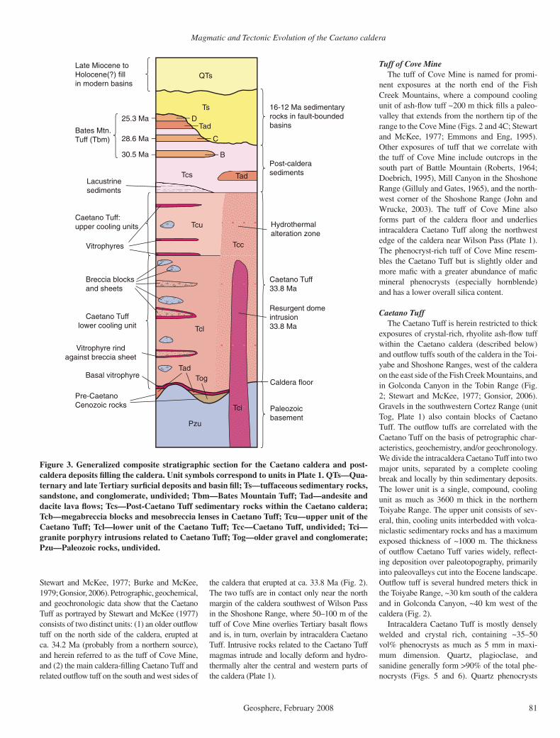
Figure 3. Generalized composite stratigraphic section for the Caetano caldera and post-caldera deposits fi lling the caldera. Unit symbols correspond to units in Plate 1. QTs—Qua-ternary and late Tertiary surfi cial deposits and basin fi ll; Ts—tuffaceous sedimentary rocks, sandstone, and conglomerate, undivided; Tbm—Bates Mountain Tuff; Tad—andesite and dacite lava fl ows; Tcs—Post-Caetano Tuff sedimentary rocks within the Caetano caldera; Tcb—megabreccia blocks and mesobreccia lenses in Caetano Tuff; Tcu—upper unit of the Caetano Tuff; Tcl—lower unit of the Caetano Tuff; Tcc—Caetano Tuff, undivided; Tci—granite porphyry intrusions related to Caetano Tuff; Tog—older gravel and conglomerate; Pzu—Paleozoic rocks, undivided.
Tuff of Cove MineThe tuff of Cove Mine is named for promi-
nent exposures at the north end of the Fish Creek Mountains, where a compound cooling unit of ash-fl ow tuff ~200 m thick fi lls a paleo-valley that extends from the northern tip of the range to the Cove Mine (Figs. 2 and 4C; Stewart and McKee, 1977; Emmons and Eng, 1995). Other exposures of tuff that we correlate with the tuff of Cove Mine include outcrops in the south part of Battle Mountain (Roberts, 1964; Doebrich, 1995), Mill Canyon in the Shoshone Range (Gilluly and Gates, 1965), and the north-west corner of the Shoshone Range (John and Wrucke, 2003). The tuff of Cove Mine also forms part of the caldera fl oor and underlies intracaldera Caetano Tuff along the northwest edge of the caldera near Wilson Pass (Plate 1). The phenocryst-rich tuff of Cove Mine resem-bles the Caetano Tuff but is slightly older and more mafi c with a greater abundance of mafi c mineral phenocrysts (especially hornblende) and has a lower overall silica content.
Caetano TuffThe Caetano Tuff is herein restricted to thick
exposures of crystal-rich, rhyolite ash-fl ow tuff within the Caetano caldera (described below) and outfl ow tuffs south of the caldera in the Toi-yabe and Shoshone Ranges, west of the caldera on the east side of the Fish Creek Mountains, and in Golconda Canyon in the Tobin Range (Fig. 2; Stewart and McKee, 1977; Gonsior, 2006). Gravels in the southwestern Cortez Range (unit Tog, Plate 1) also contain blocks of Caetano Tuff. The outfl ow tuffs are correlated with the Caetano Tuff on the basis of petrographic char-acteristics, geochemistry, and/or geochronology. We divide the intracaldera Caetano Tuff into two major units, separated by a complete cooling break and locally by thin sedimentary deposits. The lower unit is a single, compound, cooling unit as much as 3600 m thick in the northern Toiyabe Range. The upper unit consists of sev-eral, thin, cooling units interbedded with volca-niclastic sedimentary rocks and has a maximum exposed thickness of ~1000 m. The thickness of outfl ow Caetano Tuff varies widely, refl ect-ing deposition over paleotopography, primarily into paleovalleys cut into the Eocene landscape. Outfl ow tuff is several hundred meters thick in the Toiyabe Range, ~30 km south of the caldera and in Golconda Canyon, ~40 km west of the caldera (Fig. 2).
Intracaldera Caetano Tuff is mostly densely welded and crystal rich, containing ~35–50 vol% phenocrysts as much as 5 mm in maxi-mum dimension. Quartz, plagioclase, and sanidine generally form >90% of the total phe-nocrysts (Figs. 5 and 6). Quartz phenocrysts

John et al.
82 Geosphere, February 2008
Fig
ure
4. P
hoto
grap
hs s
how
ing
pre-
Cae
tano
cal
dera
geo
logy
. (A
) C
hert
-peb
ble
cong
lom
erat
e un
derl
ying
cal
dera
fl oo
r ne
ar C
aeta
no R
anch
in t
he n
orth
ern
Toiy
abe
Ran
ge. R
ocks
ar
e th
ough
t to
be p
art o
f the
Pen
nsyl
vani
an-P
erm
ian
Ant
ler
Ove
rlap
seq
uenc
e. H
amm
er is
46
cm lo
ng. (
B) M
iddl
e Te
rtia
ry c
ongl
omer
ate
form
ing
cald
era
fl oor
on
nort
hwes
t sid
e of
th
e To
iyab
e R
ange
. Wel
l-lit
hifi e
d, n
on-c
alca
reou
s co
nglo
mer
ate
cont
ains
cla
sts
of P
aleo
zoic
qua
rtzi
te, c
hert
, and
arg
illit
e, M
esoz
oic(
?) g
rani
te a
nd d
iori
te, a
nd s
ever
al te
xtur
al ty
pes
of T
erti
ary
fl ow
-ban
ded
rhyo
lite
(Tr)
up
to 1
.5 m
in d
iam
eter
. (C
) Vie
w lo
okin
g so
uth
alon
g th
e cr
est
of t
he n
orth
end
of
the
Fis
h C
reek
Mou
ntai
ns. Q
uest
a in
for
egro
und
is f
orm
ed
by fl
at-l
ying
tuf
f of
Cov
e M
ine
that
fi lls
a p
aleo
valle
y. H
ighe
r pa
rt o
f ra
nge
in b
ackg
roun
d is
com
pris
ed o
f F
ish
Cre
ek M
ount
ains
Tuf
f th
at fi
lls t
he y
oung
er F
ish
Cre
ek M
ount
ains
ca
lder
a. (
D)
Vie
w n
orth
of
Hor
se M
ount
ain,
Wils
on P
ass,
and
nor
th m
argi
n of
the
Cae
tano
cal
dera
. Hor
se M
ount
ain
com
pose
d of
Pal
eozo
ic q
uart
zite
and
arg
illit
e (P
z). C
alde
ra-
boun
ding
fau
lt li
es a
t ba
se o
f ta
lus
slop
es. L
ow a
rea
of W
ilson
Pas
s co
mpo
sed
of p
oorl
y ex
pose
d m
esob
recc
ia (
Tcb;
Fig
. 6D
). D
ense
ly w
elde
d in
trac
alde
ra C
aeta
no T
uff
(Tcc
) fo
rms
ridg
e in
for
egro
und
and
dips
~40
° ea
st (
righ
t).
Magmatic and Tectonic Evolution of the Caetano caldera
Geosphere, February 2008 83
commonly are dark gray to black (smoky) and partly resorbed. Total mafi c mineral content generally is <4%. Biotite is the main mafi c min-eral, with trace amounts of hornblende present locally. Euhedral allanite crystals as much as 1 mm long, apatite, and zircon are common acces-sory phenocryst phases.
The lower unit of Caetano Tuff (map unit Tcl, Plate 1) is a compound cooling unit of relatively homogeneous, generally densely welded rhyo-lite and high-silica rhyolite ash-fl ow tuff (Fig. 7A). A 10–20-m-thick basal vitrophyre is pre-served along the caldera fl oor in the northern Toiyabe Range (Fig. 7B), and numerous thin vitrophyric zones are irregularly distributed throughout the tuff in this part of the caldera (Gilluly and Masursky, 1965). Many of these vitrophyric zones envelop beds of mesobreccia or zones of tuff rich in lithic clasts (Fig. 7C), similar to vitrophyres quenched against meso-breccia in calderas in San Juan volcanic fi eld (Hon and Lipman, 1989; Lipman, 2000, p. 27 and Fig. 7 therein). Nearly all other exposures of the intracaldera tuff are devitrifi ed, and tuff in the western half of the caldera is hydrother-mally altered. Clasts in the tuff include Paleo-zoic quartzite, chert, argillite, and limestone, granitic rocks, and Tertiary rhyolites, dacites, and andesites. Limestone, granite, and rhyolite clasts were only observed in the northern Toi-yabe Range, near outcrops of the same rocks outside the caldera. Lithic content of the tuff varies signifi cantly—Gilluly and Masursky (1965) described conglomerate beds in the tuff. These beds actually are zones of lithic-rich tuff (lag deposits) or non-tuffaceous mesobreccia that locally contain blocks of pre-caldera rocks as much as 5 m across (Fig. 7C). The pumice content of the tuff varies signifi cantly, but nearly everywhere the crystal-rich pumice are strongly fl attened (Fig. 7B) and generally <15 cm in maximum dimension.
The upper Caetano Tuff (map unit Tcu, Plate 1) lies above a pronounced welding break at the top of the lower unit (Fig. 8A) and locally is marked at its base by ~5 m of fi nely laminated, tuffaceous siltstone and sandstone. The upper unit consists of numerous, thin, ash fl ows inter-bedded with volcaniclastic siltstone, sandstone, and pebble conglomerate (Fig. 8B). Many of the ash fl ows are poorly welded and have under-gone vapor-phase alteration, although thin, densely welded vitrophyres are present locally. The upper unit is widely exposed in the western half of the caldera (Plate 1), but both the upper and lower units are pervasively hydrothermally altered throughout these exposures and not everywhere distinguished on Plate 1. Exposures of relatively unaltered upper unit are best seen south of Rocky Pass along the crest and on the
00
5
10
15
20
25
1 2 3 4 5 6 7 8 9 10Percent Mafic Mineral Phenocrysts
Nu
mb
er o
f An
alys
es
0
5
10
15
20
25
30
35
40
45
100 20 30 40 50 60 70Percent Total Phenocrysts
Caetano Tuff, intracaldera (38 samples)Caetano Tuff, extracaldera (16)Carico Lake intrusions (5)Tuff of Cove Mine (16)06-DJ-13 (basal Wilson Pass)
Nu
mb
er o
f An
alys
es
A
B
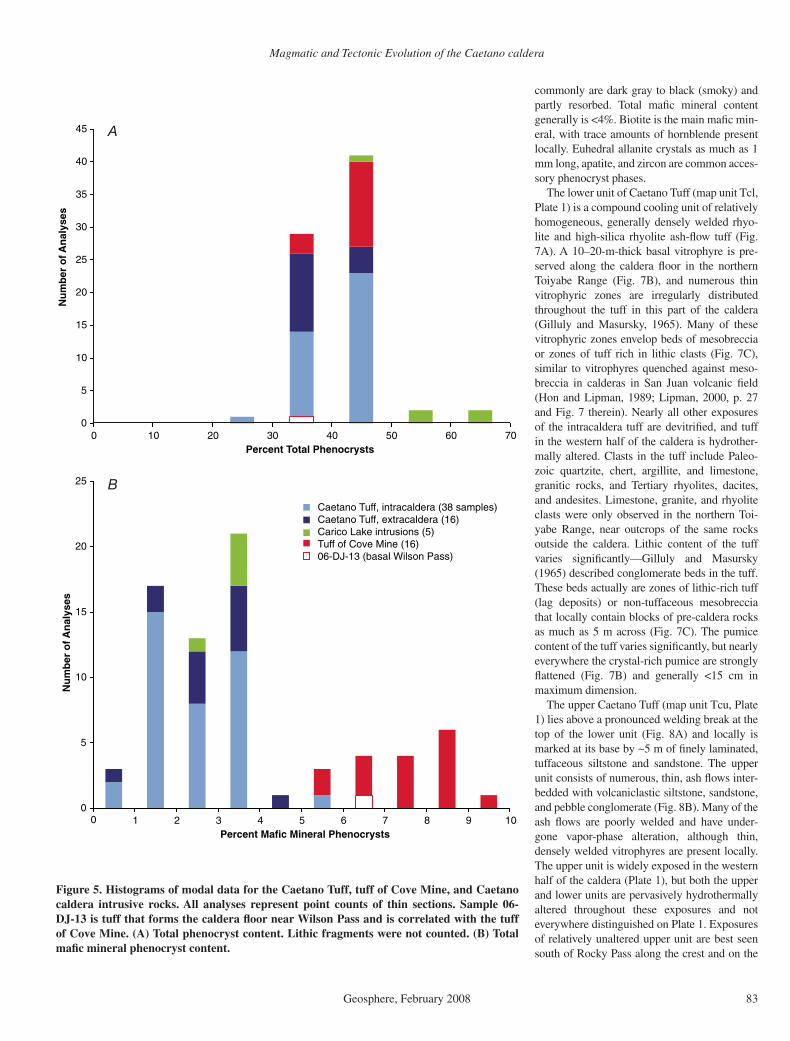
Figure 5. Histograms of modal data for the Caetano Tuff, tuff of Cove Mine, and Caetano caldera intrusive rocks. All analyses represent point counts of thin sections. Sample 06-DJ-13 is tuff that forms the caldera fl oor near Wilson Pass and is correlated with the tuff of Cove Mine. (A) Total phenocryst content. Lithic fragments were not counted. (B) Total mafi c mineral phenocryst content.

John et al.
84 Geosphere, February 2008
Caetano caldera near Wilson Pass (Fig. 2), range from 34.21 ± 0.10 (Wilson Pass) to 34.23 ± 0.09 Ma, with a mean and standard deviation of 34.22 ± 0.01 Ma. Figure 9 illustrates the distinct age difference between the Caetano Tuff and the tuff of Cove Mine, consistent with it being exposed below the Caetano Tuff. A sample of the tuff of Cove Mine dated at the USGS in Menlo Park is 34.45 ± 0.08 Ma. An additional sample from Caetano-like tuff collected at Bald Mountain 100 km east of the caldera (Fig. 1) yielded an age of 35.10 ± 0.06 Ma; thus, this sample is not related to either the Caetano Tuff or the tuff of Cove Mine.
Caetano Intrusive RocksSeveral bodies of granite porphyry intrude
the central and west-central parts of the caldera (Plate 1). The largest intrusion is the ~25 km2 Carico Lake pluton that intrudes the center of the caldera in Carico Lake Valley. The Carico Lake pluton consists of 55–65 vol%, 1–5 mm phenocrysts of smoky quartz, sanidine, pla-gioclase and 3–4% biotite and hornblende in a microcrystalline (0.05–0.1 mm) groundmass of quartz and feldspar. Sparse sanidine phenocrysts as much as 2 cm long are poikilitic and contain numerous plagioclase inclusions. Small miaro-litic cavities are common. The pluton locally is strongly fl ow banded (Fig. 7D). The modal and chemical compositions of the pluton are similar to the Caetano Tuff, and it yielded a 40Ar/39Ar age of 33.78 ± 0.05 Ma, analytically indistin-guishable from the Caetano Tuff that it intrudes (Table 1). The geochronologic data indicate that the maximum time between ash-fl ow eruption-caldera collapse and emplacement and cooling of the intrusion could therefore not have been more than ca. 0.1 Ma. The pluton appears to have domed the surrounding Caetano Tuff (as described below), and we interpret it as a resur-gent intrusion of the magma that formed the Caetano Tuff.
The Redrock Canyon pluton intrudes the upper unit of the Caetano Tuff across the west-ern part of the caldera between Redrock Canyon and Carico Lake Valley (Plate 1). It is exposed as scattered, strongly altered intrusive bodies that crop out in fault-bounded blocks, and it is inferred to be more extensive in the subsurface. The pluton is a medium-grained granite por-phyry containing ~30%, 1–5 mm phenocrysts of rounded smoky quartz, tabular sanidine, and altered plagioclase and biotite in a felsite ground-mass now altered to kaolinite and quartz.
A small, fi ne-grained, holocrystalline gran-ite porphyry intrudes the north margin of the caldera at the north end of Carico Lake Valley and is interpreted as a ring-fracture intrusion. It consists of ~45 vol% phenocrysts composed of
K-feldspar
Quartz
Plagioclase
Caetano Tuff, intracalderaCaetano Tuff, extracalderaCarico Lake intrusionsTuff of Cove Mine06-DJ-13 (basal Wilson Pass)
Figure 6. Ternary plot showing relative modal abundances of quartz, plagioclase, and K-feldspar phenocrysts in the Caetano Tuff, tuff of Cove Mine, and Caetano caldera intrusive rocks. All analyses represent point counts of thin sections.
east side of the ridge running south toward Red Mountain and in the low hills northwest of Tub Spring (Fig. 8C). In this area, the upper unit consists of multiple, thin, poorly to moderately welded ash fl ows locally containing abundant blocks of the densely welded lower unit (Fig. 8D). Thin (5–10 m) zones of more densely welded tuff within the poorly welded tuff indi-cate that the upper unit is composed of multiple, thin, cooling units that are petrographically and geochemically similar to the main (lower) unit.
Outfl ow tuffs correlated with the Caetano Tuff are found to the west and south sides of the caldera and as blocks in a gravel deposit (unit Tog, Plate 1) in the Cortez Range. They are gen-erally moderately to densely welded and lithic poor, commonly with vitrophyric zones, notably in exposures south of the caldera. These tuffs are petrographically and geochemically similar to intracaldera Caetano Tuff (Figs. 5 and 6). In contrast, samples of the tuff of Cove Mine (pre-viously mapped as Caetano Tuff) collected from the north side of the caldera in the northern Fish Creek Mountains, Battle Mountain, and north-ern Shoshone Range (Fig. 1) generally have sig-nifi cantly greater total mafi c mineral (6–10%) and plagioclase contents than the intracaldera tuff. The tuff of Cove Mine typically contains 5–8 vol% biotite and 1–2% hornblende, com-pared to 1–3% biotite and 0–0.5% hornblende in the Caetano Tuff.
New 40Ar/39Ar dates, together with petro-graphic and geochemical data, demonstrate that the Caetano Tuff as previously mapped consists of two distinct tuffs that erupted at ca. 34.2 and 33.8 Ma. Nine samples of intracaldera and out-fl ow Caetano Tuff were analyzed, including three samples from the northern Toiyabe Range that span nearly the entire stratigraphic thick-ness (>3.4 km) of intracaldera tuff, two samples from the lowest exposed intracaldera tuff at Moss Creek Canyon and south of Rocky Pass, and two samples of outfl ow tuff, one from 2 km southwest of the southwestern corner of the cal-dera and one from 45 km west of the caldera at Golconda Canyon (Fig. 2). They yielded ages ranging from 33.71 ± 0.07 to 33.85 ± 0.09 Ma (Table 1), with a mean and standard deviation of 33.79 ± 0.05 Ma. Ages from the two outfl ow samples fall within the range of the intracaldera samples (Table 1). A sample of pyroclastic-fall tuff in gravel in the Cortez Range dated at the U.S. Geological Survey (USGS) in Menlo Park is 33.97 ± 0.20 Ma. This age overlaps at 2σ with the Caetano Tuff ages determined at New Mexico Tech, and, thus, it may be related to the Caetano eruption, but this comparison and one for a sample of the tuff of Cove Mine from the northernmost Shoshone Range may be subject to a slight interlaboratory bias.
Ages of four samples from the tuff of Cove Mine, including one from the fl oor of the
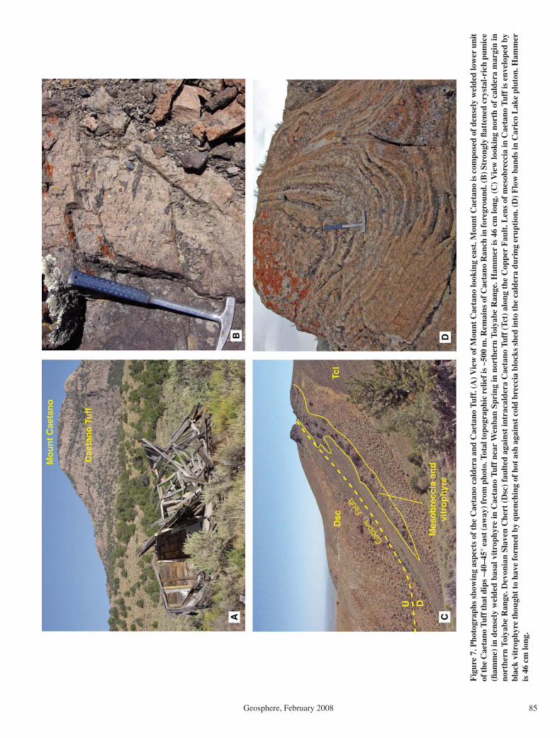
Magmatic and Tectonic Evolution of the Caetano caldera
Geosphere, February 2008 85
Fig
ure
7. P
hoto
grap
hs s
how
ing
aspe
cts
of th
e C
aeta
no c
alde
ra a
nd C
aeta
no T
uff.
(A) V
iew
of M
ount
Cae
tano
look
ing
east
. Mou
nt C
aeta
no is
com
pose
d of
den
sely
wel
ded
low
er u
nit
of th
e C
aeta
no T
uff t
hat d
ips
~40–
45°
east
(aw
ay) f
rom
pho
to. T
otal
topo
grap
hic
relie
f is
~500
m. R
emai
ns o
f Cae
tano
Ran
ch in
fore
grou
nd. (
B) S
tron
gly
fl att
ened
cry
stal
-ric
h pu
mic
e (fi
am
me)
in d
ense
ly w
elde
d ba
sal v
itro
phyr
e in
Cae
tano
Tuf
f ne
ar W
enba
n Sp
ring
in n
orth
ern
Toiy
abe
Ran
ge. H
amm
er is
46
cm lo
ng. (
C)
Vie
w lo
okin
g no
rth
of c
alde
ra m
argi
n in
no
rthe
rn T
oiya
be R
ange
. Dev
onia
n Sl
aven
Che
rt (
Dsc
) fa
ulte
d ag
ains
t in
trac
alde
ra C
aeta
no T
uff
(Tct
) al
ong
the
Cop
per
Fau
lt. L
ens
of m
esob
recc
ia in
Cae
tano
Tuf
f is
env
elop
ed b
y bl
ack
vitr
ophy
re th
ough
t to
have
form
ed b
y qu
ench
ing
of h
ot a
sh a
gain
st c
old
brec
cia
bloc
ks s
hed
into
the
cald
era
duri
ng e
rupt
ion.
(D) F
low
ban
ds in
Car
ico
Lak
e pl
uton
. Ham
mer
is
46
cm lo
ng.
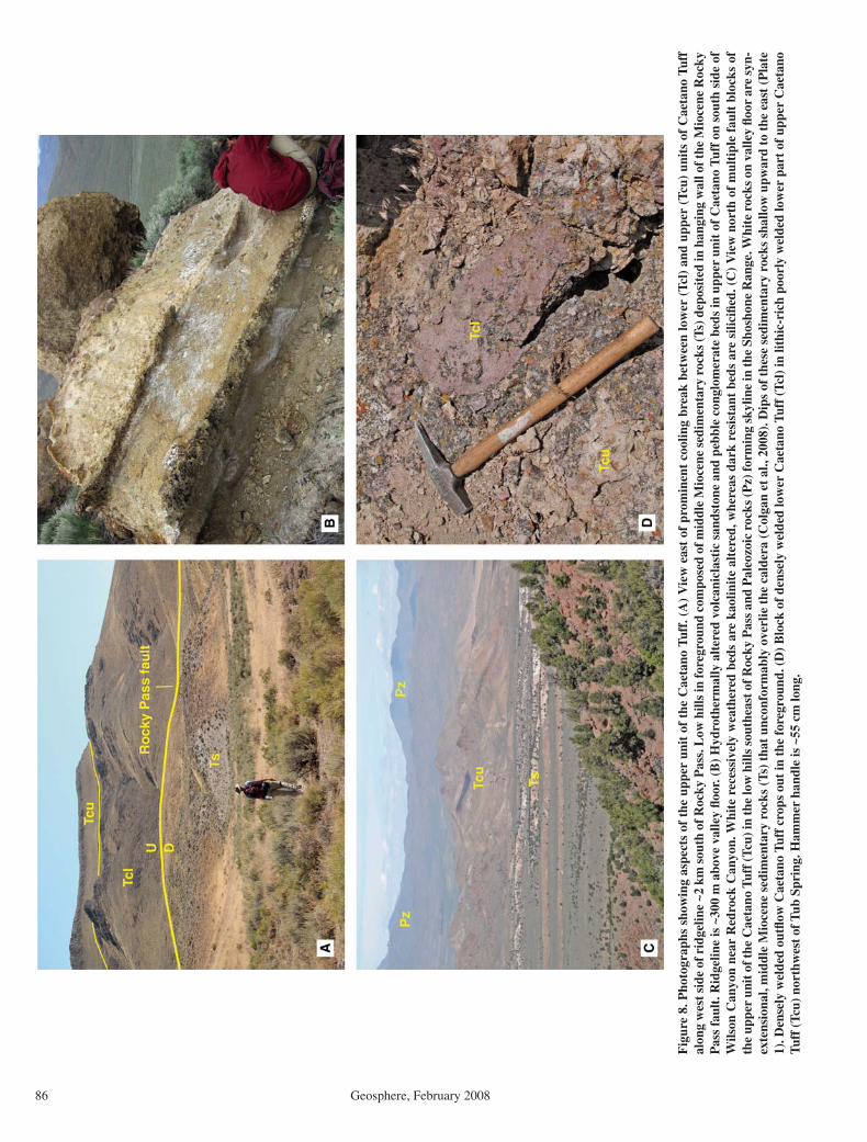
John et al.
86 Geosphere, February 2008
Fig
ure
8. P
hoto
grap
hs s
how
ing
aspe
cts
of t
he u
pper
uni
t of
the
Cae
tano
Tuf
f. (
A)
Vie
w e
ast
of p
rom
inen
t co
olin
g br
eak
betw
een
low
er (
Tcl)
and
upp
er (
Tcu)
uni
ts o
f C
aeta
no T
uff
alon
g w
est s
ide
of r
idge
line
~2 k
m s
outh
of R
ocky
Pas
s. L
ow h
ills
in fo
regr
ound
com
pose
d of
mid
dle
Mio
cene
sed
imen
tary
roc
ks (T
s) d
epos
ited
in h
angi
ng w
all o
f the
Mio
cene
Roc
ky
Pas
s fa
ult.
Rid
gelin
e is
~30
0 m
abo
ve v
alle
y fl o
or. (
B)
Hyd
roth
erm
ally
alt
ered
vol
cani
clas
tic
sand
ston
e an
d pe
bble
con
glom
erat
e be
ds in
upp
er u
nit
of C
aeta
no T
uff
on s
outh
sid
e of
W
ilson
Can
yon
near
Red
rock
Can
yon.
Whi
te r
eces
sive
ly w
eath
ered
bed
s ar
e ka
olin
ite
alte
red,
whe
reas
dar
k re
sist
ant
beds
are
sili
cifi e
d. (
C)
Vie
w n
orth
of
mul
tipl
e fa
ult
bloc
ks o
f th
e up
per
unit
of t
he C
aeta
no T
uff (
Tcu)
in th
e lo
w h
ills
sout
heas
t of R
ocky
Pas
s an
d P
aleo
zoic
roc
ks (P
z) fo
rmin
g sk
ylin
e in
the
Shos
hone
Ran
ge. W
hite
roc
ks o
n va
lley
fl oor
are
syn
-ex
tens
iona
l, m
iddl
e M
ioce
ne s
edim
enta
ry r
ocks
(Ts
) th
at u
ncon
form
ably
ove
rlie
the
cal
dera
(C
olga
n et
al.,
200
8). D
ips
of t
hese
sed
imen
tary
roc
ks s
hallo
w u
pwar
d to
the
eas
t (P
late
1)
. Den
sely
wel
ded
outfl
ow
Cae
tano
Tuf
f cr
ops
out
in t
he f
oreg
roun
d. (
D)
Blo
ck o
f de
nsel
y w
elde
d lo
wer
Cae
tano
Tuf
f (T
cl)
in li
thic
-ric
h po
orly
wel
ded
low
er p
art
of u
pper
Cae
tano
Tu
ff (
Tcu)
nor
thw
est
of T
ub S
prin
g. H
amm
er h
andl
e is
~55
cm
long
.

Magmatic and Tectonic Evolution of the Caetano caldera
Geosphere, February 2008 87
subhedral to euhedral plagioclase, K-feldspar, and dark-gray, rounded to strongly resorbed quartz in a microcrystalline felsic groundmass. The intrusion contains sparse, white K-feldspar phenocrysts as much as 1 cm long. Mafi c phe-nocrysts comprised of biotite, opaque minerals, and trace amounts of hornblende form ~3% of the intrusion. Sparse, small (<1 mm) miarolitic cavities are present.
Geochemistry of the Caetano Tuff, Related Intrusive Rocks, and the Tuff of Cove Mine
The Caetano Tuff and the tuff of Cove Mine are subalkaline rhyolites using total alkali-silica relations and the IUGS (International Union of the Geological Sciences) chemical classifi ca-tion (Fig. 10; Irvine and Baragar, 1971; Le Bas et al., 1989). Normalized silica contents range from 68.7 to 77.5 wt% SiO
2. Five samples of
the Carico Lake pluton and the ring-fracture intrusion have 71.3–73.3 wt% SiO
2. Total alkali
(Na2O + K
2O) contents of all samples are mostly
between 7.5 and 8.5 wt%.The tuffs clearly separate into two composi-
tional groups with different trends of major and trace elements: (1) high-silica intracaldera and extracaldera Caetano Tuff from west, south, and
east sides of the caldera, and (2) more mafi c, lower silica tuff of Cove Mine from the north side of the caldera (Fig. 10). The tuff of Cove Mine has notably higher Mg, total Fe, Ti, and P contents and lower Al, Ba, and Zr contents relative to the Caetano Tuff at the same silica content. These chemical data corroborate the separation of the extracaldera tuffs into two groups defi ned by their petrographic and modal characteristics and 40Ar/39Ar ages, and suggest that extracaldera tuffs from the west, south, and east sides of the caldera are related to intracal-dera Caetano Tuff.
Chemical analyses of intrusive rocks in Carico Lake Valley are generally similar to the intracal-dera Caetano Tuff (Fig. 10). Silica contents of the intrusive rocks are similar to the mafi c parts of the intracaldera tuff, and major and trace ele-ment contents generally lie on the same com-positional trends as the intracaldera tuffs, con-sistent with them being genetically related. The Redrock Canyon pluton is pervasively altered, and we have no chemical analyses of it.
Chemically analyzed samples of intracaldera Caetano Tuff can be projected onto cross sec-tions to estimate their relative stratigraphic posi-tion within the caldera and allow examination
of general compositional trends within intracal-dera tuff (Fig. 11). The intracaldera tuff reaches a maximum observed thickness of ~3400 m in the northern Toiyabe Range (just south of the Copper Fault, Plate 1), but neither the upper unit nor the caldera fl oor are exposed in this section. We assume that the caldera fl oor is very close to the exposed base of this section, consistent with exposures a few km to the south in the foot-wall of the Caetano Ranch Fault (Plate 1). We next assume that the cooling break between the upper and lower units is just above the top of the exposed section, buried beneath younger sedi-ments in Grass Valley; this yields a thickness of ~3600 m for the lower unit. No single fault block exposes both the caldera fl oor and the top of the upper unit; therefore, we estimate the stratigraphic position of our samples relative to either the cooling break between the upper and lower units or the exposed caldera fl oor. They are plotted on Figure 11 relative to their inferred stratigraphic height (in meters) above the cal-dera fl oor. Varying the assumed thickness of the lower cooling unit will thus stretch the vertical axis of the Figure 11, but will not change the relative position of the plotted samples.
The basal (vitrophyric) Caetano Tuff exposed along the caldera fl oor in the northern Toiyabe Range is high-silica rhyolite containing 76.2–76.4 wt% SiO
2. The lower ~2800 m of the intra-
caldera tuff shows little compositional zoning with high silica contents (76.0–77.7 wt% SiO
2)
throughout. Samples collected near the top of the lower unit in the northern Toiyabe Range, Tub Spring, Rocky Pass, and Carico Lake Val-ley areas all have markedly lower silica con-tents, 71.8–73.5 wt% SiO
2, than samples from
the lower part of the tuff. Silica contents of the upper unit range from 71.9 to 75.6 wt%, over-lapping silica contents of the upper part of the lower unit and extending to higher values. Silica content increases abruptly ~1.5–2 wt% from the lower to upper units in the Rocky Pass section.
Combined stratigraphic and geochemical data for intracaldera Caetano Tuff and related intru-sive rocks suggest four major trends. (1) Thick, relatively homogeneous, high-silica rhyolite (76–78 wt% SiO
2) forms most of the intracal-
dera tuff. (2) More mafi c rhyolite compositions (72–74% SiO
2) comprise the upper ~700 m of
the lower unit, indicating overall normal compo-sitional zoning upward in this single compound cooling unit. (3) The upper unit tends to be more silicic than the upper part of the lower unit, but overall it displays a wider range of composi-tions, probably refl ecting smaller volume, less widespread (?) eruptions. (4) The Carico Lake pluton and the ring-fracture intrusion have com-positions (71–73% SiO
2) overlapping to slightly
more mafi c than the upper part of the lower unit,
Figure 9. 40Ar/39Ar single-crystal data in age probability diagrams of two samples each of Caetano Tuff (05-DJ-14, 05-DJ-27) and tuff of Cove Mine (06-DJ-13, 05-DJ-8) showing dis-tinctly different ages of each. Unfi lled data points were not used in age calculation.
% Radiogenic Argon
K/Ca
Individual sanidine analysesand uncertainties
96
100
Age-Probability Spectra: 05-DJ-14, 05-DJ-27, 06-DJ-13 and 05-DJ-8
40
80
20
50
32.0 32.5 33.0 33.5 34.0 34.5 35.0 35.5 36.00
10
20
30
40
50
33.82
33.84 ± 0.08, MSWD = 1.91
33.82
33.85 ± 0.09, MSWD = 1.85
34.19
34.21 ± 0.10, MSWD = 1.99
34.24
34.22 ± 0.06, MSWD = 1.29
Age (Ma)
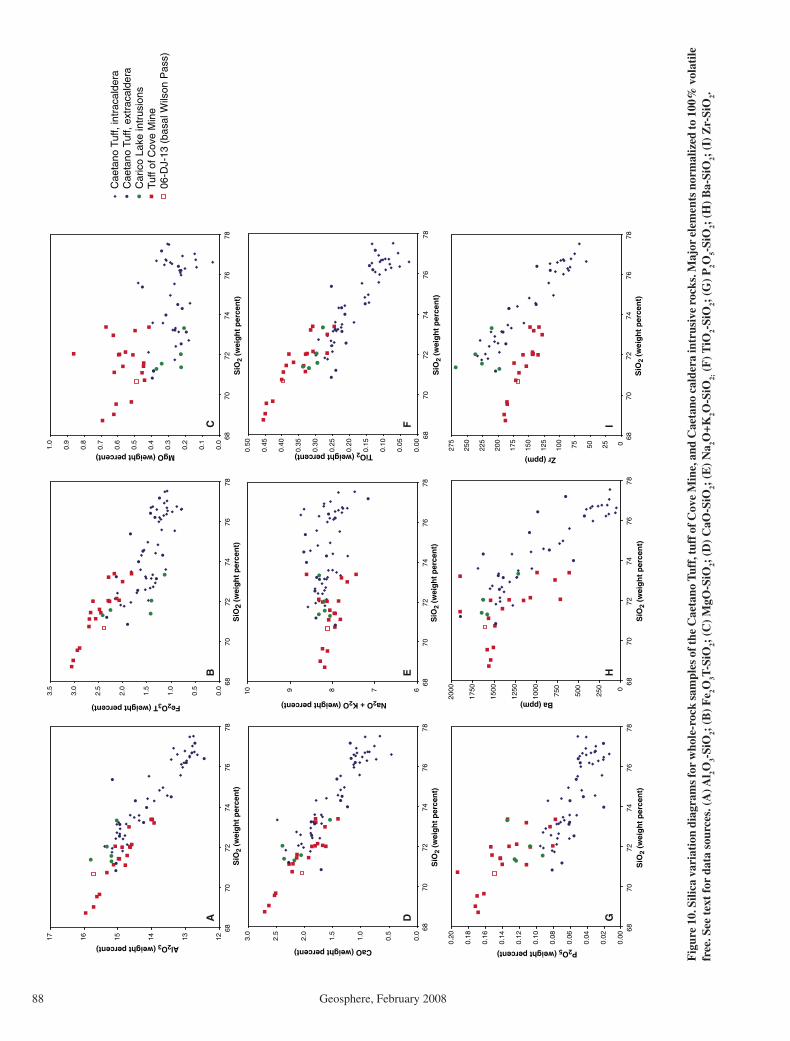
John et al.
88 Geosphere, February 2008
0255075100
125
150
175
200
225
250
275 68
7072
7476
78S
iO2
(wei
gh
t p
erce
nt)
Zr (ppm)
0.00
0.02
0.04
0.06
0.08
0.10
0.12
0.14
0.16
0.18
0.20
6870
7274
7678
SiO
2 (w
eig
ht
per
cen
t)
P2O5 (weight percent)
0.0
0.5
1.0
1.5
2.0
2.5
3.0
6870
7274
7678
SiO
2 (w
eig
ht
per
cen
t)
CaO (weight percent)
121314151617
6870
7274
7678
SiO
2 (w
eig
ht
per
cen
t)
Al2O3 (weight percent)
0.0
0.5
1.0
1.5
2.0
2.5
3.0
3.5
6870
7274
7678
SiO
2 (w
eig
ht
per
cen
t)
Fe2O3T (weight percent)
Cae
tano
Tuf
f, in
trac
alde
raC
aeta
no T
uff,
extr
acal
dera
Car
ico
Lake
intr
usio
nsTu
ff of
Cov
e M
ine
06-D
J-13
(ba
sal W
ilson
Pas
s)
0
250
500
750
1000
1250
1500
1750
2000
6870
7274
7678
SiO
2 (w
eig
ht
per
cen
t)
Ba (ppm)
AB
C
DE
F
GH
I
678910
6870
7274
7678
SiO
2 (w
eig
ht
per
cen
t)
Na2O + K2O (weight percent)
0.00
0.05
0.10
0.15
0.20
0.25
0.30
0.35
0.40
0.45
0.50
6870
7274
7678
SiO
2 (w
eig
ht
per
cen
t)
TiO2 (weight percent)
0.0
0.1
0.2
0.3
0.4
0.5
0.6
0.7
0.8
0.9
1.0
6870
7274
7678
SiO
2 (w
eig
ht
per
cen
t)
MgO (weight percent)
Fig
ure
10. S
ilica
var
iati
on d
iagr
ams
for
who
le-r
ock
sam
ples
of t
he C
aeta
no T
uff,
tuff
of C
ove
Min
e, a
nd C
aeta
no c
alde
ra in
trus
ive
rock
s. M
ajor
ele
men
ts n
orm
aliz
ed to
100
% v
olat
ile
free
. See
tex
t fo
r da
ta s
ourc
es. (
A) A
l 2O3-
SiO
2; (
B)
Fe 2O
3T-S
iO2;
(C
) M
gO-S
iO2;
(D
) C
aO-S
iO2;
(E
) N
a 2O+K
2O-S
iO2; (
F) T
iO2-
SiO
2; (
G)
P2O
5-Si
O2;
(H
) B
a-Si
O2;
(I)
Zr-
SiO
2.
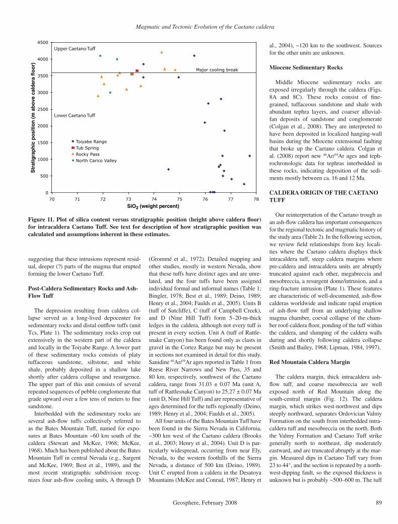
Magmatic and Tectonic Evolution of the Caetano caldera
Geosphere, February 2008 89
suggesting that these intrusions represent resid-ual, deeper (?) parts of the magma that erupted forming the lower Caetano Tuff.
Post-Caldera Sedimentary Rocks and Ash-Flow Tuff
The depression resulting from caldera col-lapse served as a long-lived depocenter for sedimentary rocks and distal outfl ow tuffs (unit Tcs, Plate 1). The sedimentary rocks crop out extensively in the western part of the caldera and locally in the Toiyabe Range. A lower part of these sedimentary rocks consists of platy tuffaceous sandstone, siltstone, and white shale, probably deposited in a shallow lake shortly after caldera collapse and resurgence. The upper part of this unit consists of several repeated sequences of pebble conglomerate that grade upward over a few tens of meters to fi ne sandstone.
Interbedded with the sedimentary rocks are several ash-fl ow tuffs collectively referred to as the Bates Mountain Tuff, named for expo-sures at Bates Mountain ~60 km south of the caldera (Stewart and McKee, 1968; McKee, 1968). Much has been published about the Bates Mountain Tuff in central Nevada (e.g., Sargent and McKee, 1969; Best et al., 1989), and the most recent stratigraphic subdivision recog-nizes four ash-fl ow cooling units, A through D
(Grommé et al., 1972). Detailed mapping and other studies, mostly in western Nevada, show that these tuffs have distinct ages and are unre-lated, and the four tuffs have been assigned individual formal and informal names (Table 1; Bingler, 1978; Best et al., 1989; Deino, 1989; Henry et al., 2004; Faulds et al., 2005). Units B (tuff of Sutcliffe), C (tuff of Campbell Creek), and D (Nine Hill Tuff) form 5–20-m-thick ledges in the caldera, although not every tuff is present in every section. Unit A (tuff of Rattle-snake Canyon) has been found only as clasts in gravel in the Cortez Range but may be present in sections not examined in detail for this study. Sanidine 40Ar/39Ar ages reported in Table 1 from Reese River Narrows and New Pass, 35 and 80 km, respectively, southwest of the Caetano caldera, range from 31.03 ± 0.07 Ma (unit A, tuff of Rattlesnake Canyon) to 25.27 ± 0.07 Ma (unit D, Nine Hill Tuff) and are representative of ages determined for the tuffs regionally (Deino, 1989; Henry et al., 2004; Faulds et al., 2005).
All four units of the Bates Mountain Tuff have been found in the Sierra Nevada in California, ~300 km west of the Caetano caldera (Brooks et al., 2003; Henry et al., 2004). Unit D is par-ticularly widespread, occurring from near Ely, Nevada, to the western foothills of the Sierra Nevada, a distance of 500 km (Deino, 1989). Unit C erupted from a caldera in the Desatoya Mountains (McKee and Conrad, 1987; Henry et
al., 2004), ~120 km to the southwest. Sources for the other units are unknown.
Miocene Sedimentary Rocks
Middle Miocene sedimentary rocks are exposed irregularly through the caldera (Figs. 8A and 8C). These rocks consist of fi ne-grained, tuffaceous sandstone and shale with abundant tephra layers, and coarser alluvial-fan deposits of sandstone and conglomerate (Colgan et al., 2008). They are interpreted to have been deposited in localized hanging-wall basins during the Miocene extensional faulting that broke up the Caetano caldera. Colgan et al. (2008) report new 40Ar/39Ar ages and teph-rochronologic data for tephras interbedded in these rocks, indicating deposition of the sedi-ments mostly between ca. 16 and 12 Ma.
CALDERA ORIGIN OF THE CAETANO TUFF
Our reinterpretation of the Caetano trough as an ash-fl ow caldera has important consequences for the regional tectonic and magmatic history of the study area (Table 2). In the following section, we review fi eld relationships from key locali-ties where the Caetano caldera displays thick intracaldera tuff, steep caldera margins where pre-caldera and intracaldera units are abruptly truncated against each other, megabreccia and mesobreccia, a resurgent dome/intrusion, and a ring-fracture intrusion (Plate 1). These features are characteristic of well-documented, ash-fl ow calderas worldwide and indicate rapid eruption of ash-fl ow tuff from an underlying shallow magma chamber, coeval collapse of the cham-ber roof-caldera fl oor, ponding of the tuff within the caldera, and slumping of the caldera walls during and shortly following caldera collapse (Smith and Bailey, 1968; Lipman, 1984, 1997).
Red Mountain Caldera Margin
The caldera margin, thick intracaldera ash-fl ow tuff, and coarse mesobreccia are well exposed north of Red Mountain along the south-central margin (Fig. 12). The caldera margin, which strikes west-northwest and dips steeply northward, separates Ordovician Valmy Formation on the south from interbedded intra-caldera tuff and mesobreccia on the north. Both the Valmy Formation and Caetano Tuff strike generally north to northeast, dip moderately eastward, and are truncated abruptly at the mar-gin. Measured dips in Caetano Tuff vary from 23 to 44°, and the section is repeated by a north-west-dipping fault, so the exposed thickness is unknown but is probably ~500–600 m. The tuff
0
500
1000
1500
2000
2500
3000
3500
4000
4500
70 71 72 73 74 75 76 77 78
SiO2 (weight percent)
Str
atig
rap
hic
po
siti
on
(m
ab
ove
cal
der
a fl
oo
r)
Toiyabe RangeTub SpringRocky PassNorth Carico Valley
Major cooling break
Upper Caetano Tuff
Lower Caetano Tuff
Figure 11. Plot of silica content versus stratigraphic position (height above caldera fl oor) for intracaldera Caetano Tuff. See text for description of how stratigraphic position was calculated and assumptions inherent in these estimates.

John et al.
90 Geosphere, February 2008
is mostly densely welded and strongly altered, with feldspar and biotite phenocrysts altered to kaolinite. Lithic fragments are generally sparse, but are locally abundant immediately above sev-eral mesobreccia lenses and in poorly welded tuff near the top of the ridge.
Several lenses of mesobreccia are interbed-ded with tuff. They are 5–10 m thick and are composed of angular, clast- to matrix-supported clasts up to 50 cm in diameter (Fig. 13A). Most lenses are massive and unsorted, but one lens has irregular zones characterized by different clast sizes. The zones are nonplanar and commonly strongly oblique to layering in the surrounding ash-fl ow tuff. Clasts in the lower breccia lenses are almost entirely Paleozoic quartzite and argillite, with sparse Tertiary andesite. Upper lenses also contain clasts of Caetano Tuff and pumice up to 50 cm in diameter. Matrix in all lenses consists of fi nely ground Paleozoic rocks. Lithic-rich tuff overlies one of the uppermost mesobreccia lenses with sharp contact.
The capping mesobreccia (unit Tcb, Fig. 12) consists of a heterogeneous mix of mas-sive to moderately well-bedded, very coarse to fi ne deposits. The massive deposits are mostly similar to the interbedded lenses but contain angular quartzite clasts up to 1 m in diameter. Lag blocks of quartzite up to 2 m in diameter were probably eroded out of breccia deposits.
TABLE 2. CHARACTERISTICS OF ASH-FLOW CALDERAS AND VOLCANO-TECTONIC TROUGHS Calderas Volcano-tectonic troughs Primary map shape Generally approximately equant Highly elongate
Cross section Symmetrical subsidence Half graben rather than graben?
Evidence for regional extension perpendicular to trough (long axis)
Not necessary Essential
Boundary Near vertical faults around entire caldera Extensional faults might dip ~65°; faults bound sides, not ends
Ash-flow tuff character Thick, relatively homogeneous, possibly vertically zoned
Thick, possibly heterogeneous, if trough formed over long time
Megabreccia and mesobreccia Common Common?
Resurgent intrusion Common Unknown?
Interbedded tuff, lava, and sedimentary rocks
No interbedded lava. Sedimentary rocks include only mesobreccia and megabreccia or sedimentary deposits interbedded with tuff deposited during the waning stages of the caldera cycle.
Potentially common, if trough formed over long time
Other volcanic fill Caldera collapse phase should have only ash-flow tuff and breccia; post-collapse could have abundant late lavas and sedimentary rocks.
Lavas and sedimentary rocks could be throughout section
Rapid subsidence coeval with ash flow eruption
Characteristic origin Yes, but could be several episodes separated by long times
Examples Many hundreds worldwide Panther Creek, Challis field, Idaho
Qf
Qf
Tcc
Tcl
Tcbu
Tcb
Tcb
3834
35
3739
73
23
31
2842
0 1 km
Red Mountain
Red M
ount
ain F
ault
Pz
Pz
Tcc
116°52'42"40°5'56"
Alluvial fan deposits,ColluviumQf
Upper mesobreccia
Caetano Tuff
Qc
Qc
Tcbu
Mesobreccia
Pz Paleozoic rocks
Tcc
Tcb
Caetano Tuff,undivided
N
Figure 12. Geologic map of the southern caldera margin at Red Mountain (Wood Spring Canyon 7-½' quadrangle). East-dipping Caetano Tuff and interbedded mesobreccia lenses composed of Paleozoic clasts (Fig. 13A) are abruptly truncated against Paleozoic Valmy Formation at west-northwest–striking, steeply north-dipping caldera margin. Upper meso-breccia consists of interbedded lenses of Paleozoic clast debris-fl ow deposits and lithic-rich Caetano Tuff (Fig. 13B). The Red Mountain fault steps abruptly westward at and probably reactivates the caldera boundary fault.
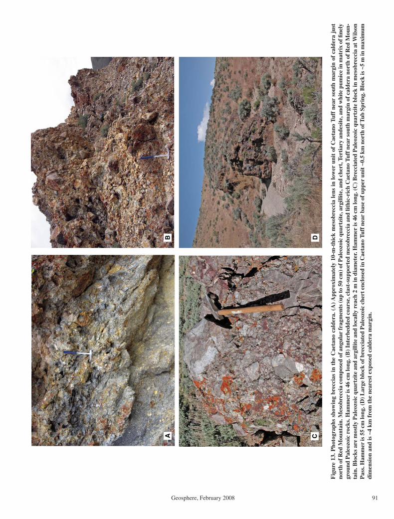
Magmatic and Tectonic Evolution of the Caetano caldera
Geosphere, February 2008 91
Fig
ure
13. P
hoto
grap
hs s
how
ing
brec
cias
in t
he C
aeta
no c
alde
ra. (
A) A
ppro
xim
atel
y 10
-m-t
hick
mes
obre
ccia
lens
in lo
wer
uni
t of
Cae
tano
Tuf
f ne
ar s
outh
mar
gin
of c
alde
ra j
ust
nort
h of
Red
Mou
ntai
n. M
esob
recc
ia c
ompo
sed
of a
ngul
ar fr
agm
ents
(up
to 5
0 cm
) of P
aleo
zoic
qua
rtzi
te, a
rgill
ite,
and
che
rt, T
erti
ary
ande
site
, and
whi
te p
umic
e in
mat
rix
of fi
nely
gr
ound
Pal
eozo
ic r
ocks
. Ham
mer
is 4
6 cm
long
. (B
) Int
erbe
dded
coa
rse,
cla
st-s
uppo
rted
mes
obre
ccia
and
lith
ic-r
ich
Cae
tano
Tuf
f nea
r so
uth
mar
gin
of c
alde
ra n
orth
of R
ed M
oun-
tain
. Blo
cks
are
mos
tly
Pal
eozo
ic q
uart
zite
and
arg
illit
e an
d lo
cally
rea
ch 2
m in
dia
met
er. H
amm
er is
46
cm lo
ng. (
C) B
recc
iate
d P
aleo
zoic
qua
rtzi
te b
lock
in m
esob
recc
ia a
t Wils
on
Pas
s. H
amm
er is
55
cm lo
ng. (
D) L
arge
blo
ck o
f bre
ccia
ted
Pal
eozo
ic c
hert
enc
lose
d in
Cae
tano
Tuf
f nea
r ba
se o
f upp
er u
nit ~
0.5
km n
orth
of T
ub S
prin
g. B
lock
is ~
5 m
in m
axim
um
dim
ensi
on a
nd is
~4
km f
rom
the
nea
rest
exp
osed
cal
dera
mar
gin.

John et al.
92 Geosphere, February 2008
Sequences of coarse breccias consist of several layers, which, individually, are one to 5 m thick. A few layers show faint internal bedding, and a few layers have tuff matrix, demonstrating that they are very lithic ash-fl ow tuffs. Finer deposits consist of moderately to well-bedded, pebbly to coarse, volcanic sandstone, with pebbles of quartzite (Fig. 13B).
We interpret the high-angle contact between Paleozoic rocks and tuff and mesobreccia to be the caldera margin. The margin originated as a fault scarp resulting from caldera collapse and, given its steepness, is probably close to the actual fault plane. However, the contact is not exposed, and debris was shed from the margin during caldera collapse, thus much of the margin is eroded topographic wall. The structurally lower, western parts of the margin
probably are closer to the actual fault than are structurally higher, eastern parts. The meso-breccia lenses within the tuff probably are rock falls or avalanches from the caldera wall, and the capping mesobreccia probably is a mix of rock fall and avalanche deposits, as well as primary ash-fl ow tuff, debris-fl ow deposits, and minor fl uvially reworked tuff and breccia. The paucity of coarse lithics in most intracal-dera tuff indicates that there was little erosion of the vent during tuff eruption and that most mesobreccia was deposited by abrupt rock falls that interacted little with the enclosing tuff that was being deposited. In contrast, the complex stratigraphy of the upper mesobreccia and the presence of a few layers with tuff matrixes sug-gest that the upper mesobreccia was deposited near the end of tuff eruption.
The caldera margin has been reactivated by, or infl uenced the location of, the Red Moun-tain fault that bounds the east side of modern Carico Lake Valley (Fig. 12). This fault, which has prominent scarps suggesting late Qua-ternary offset, strikes north-south but turns abruptly westward, where it intersects the caldera margin, probably following the margin. The fault turns back to a more northeasterly strike ~700 m to the west.
Wilson Pass Caldera Margin
The north margin of the caldera is exposed at Wilson Pass (Fig. 14) and displays several features different from those at Red Mountain. Thick, intracaldera tuff and megabreccia are present, but the margin itself is more structurally
Figure 14. Geologic map of the northern caldera margin at Wilson Pass (Goat Peak 7-½' quadrangle). Caldera boundary probably consists of two west-northwest–striking, steeply dipping faults separating Paleozoic rocks north of the northern fault, mesobreccia between the two faults, and Caetano Tuff south of the southern fault (Figs. 4D and 7D). Paleozoic rocks at Peak 7268 may be megabreccia or part of caldera wall. Caetano Tuff overlies the caldera fl oor consisting of tuff of Cove Mine underlain by basalt lava fl ows. Miocene sedimentary rocks (Tm) were deposited in the hanging wall of the middle Miocene Redrock Canyon fault (Colgan et al., 2008).
s
s s
s s s
s
s s s s s s
s
Tc
Pzu
Tc
Pzu
Tcb
Qf
Qf
QcPzTm
Tb
Tc
Qc
QfTm
Qc
Tm
Tcb
Tcm
70 44
23
40
26
38 3435 38
38
Redro
ck C
anyo
n
Fau
lt
0 1 km
Pzl
ROBERTS MTNS
THRUST
116°58'40"
40°15'54"
Colluvium and landslides,alluvial fan deposits
Miocene sedimentary rocks
Caetano Tuff, Mesobreccia
Basalt or andesite flows
Paleozoic upper platePzu
Paleozoic lower platePzl
Tb
TcbTc
Tm
QfQc
Tcm Tuff of Cove Mine
N
Magmatic and Tectonic Evolution of the Caetano caldera
Geosphere, February 2008 93
or erosionally complicated. The caldera margin strikes west-northwest and dips steeply south. Gilluly and Gates (1965) mapped two fault strands. Paleozoic rocks exposed in or near the margin, north of the north strand, include upper plate chert, quartzite, and lesser sandstone and shale. Mesobreccia and probable megabrec-cia are poorly to well exposed between the two strands (Figs. 4D and 13C). Intracaldera tuff crops out south of the south strand, dips 30–45° east, and directly overlies an exposure of the cal-dera fl oor consisting of mafi c lava fl ows and the older tuff of Cove Mine (Fig. 14). The intracal-dera tuff here is ~1800 m thick. Despite its prox-imity to the caldera margin, the Caetano Tuff in this area contains only sparse, small lithics and no breccia lenses. The tuff is altered but less so than at Red Mountain; plagioclase is generally altered to kaolinite, and biotite is locally altered to white mica or kaolinite, but sanidine gener-ally is unaltered.
Mesobreccia at Wilson Pass consists of blocks of variably brecciated quartzite and argillite in soil that locally contains pieces of Caetano Tuff (Fig. 4D). Breccia matrix is not exposed in this area; therefore, it is uncertain whether the tuff pieces are clasts or weathered from matrix. The largest clasts are themselves brecciated, with angular, monolithologic, clast-supported pieces of quartzite or argillite to 35 cm in an indurated, probably siliceous matrix. Well-exposed meso-breccia that consists of matrix-supported, angu-lar to subrounded pieces of argillite, quartzite, sandstone, and chert in a fi nely granular matrix appears to rest depositionally on Valmy quartz-ite northwest of Wilson Pass. A large, coherent outcrop of chert west of Wilson Pass (Fig. 14) may be a large breccia block or an intact part of the caldera wall.
The Wilson Pass caldera margin could con-sist of two fault strands, as mapped by Gilluly and Gates (1965), or the northern strand could be eroded caldera wall and the southern strand closer to an actual structural margin. If the latter, mesobreccia between the two strands would be resting on intact caldera wall, simi-lar to the well-exposed mesobreccia (Tcb 1 km northwest of Wilson Pass, Fig. 14). How-ever, the steepness and linearity of the north-ern strand suggests it is a fault. The absence of lower plate Paleozoic rocks in breccia indi-cates that lower plate rocks were not exposed in the topographic caldera wall at the time of caldera collapse.
Northeastern Caldera Margin—The Copper Fault
The northeastern part of the caldera in the Toiyabe Range shows thick intracaldera tuff,
an exposed caldera boundary fault, an upward transition from boundary fault to topographic wall resulting from major slumping of the wall, and megabreccia and mesobreccia (Fig. 15, Plate 1). The average dip of the Caetano Tuff is 40° indicating that exposed intracaldera tuff here is ~3400 m thick. The base of the tuff is not exposed but is probably not far below the low-est exposed tuff given exposure of the caldera fl oor ~7 km to the south (see section Caldera Floor at Caetano Ranch); therefore, we assign a thickness of 3600 m for the lower unit of the Caetano Tuff. Because the tuff and caldera are tilted, a transect east along the caldera margin is an oblique upward transect along the original margin.
The western half of the northeastern caldera margin mapped by us coincides with the Copper Fault of Gilluly and Masursky (1965). This west-ern part is probably the caldera structural bound-ary where intracaldera tuff is faulted against Paleo-zoic rocks. For example, at A (Fig. 15), a planar, 58°, southward-dipping fault surface is developed in resistant Devonian Slaven Chert, which makes a low ridge on the north against less resistant tuff and breccia on the south (Fig. 16A). Chert is intensely brecciated along the fault. Caetano Tuff crops out ~30 m to the south but is not exposed along the fault surface.
Megabreccia and mesobreccia are interbed-ded with Caetano Tuff from the Copper Fault, the northern margin, southward to near the Wenban Fault, the southern margin (Figs. 15 and 16A). Breccia near A consists of a single chert megabreccia ~30 m long with brecciated margins and several lenses of mesobreccia con-taining clasts of Paleozoic chert, quartzite, and chert-pebble conglomerate up to ~2 m in diam-eter (Figs. 7C, 16A, and 16B). Caetano Tuff forms vitrophyre adjacent to many of the meso-breccia lenses (Fig. 7C).
The caldera structural boundary is especially well exposed at B, ~1 km east of A (Fig. 15). At this location, densely welded, highly sheared Caetano Tuff is in a sharp, vertical to steeply south-dipping contact with chert in the margin (Fig. 16B). Pumice is highly stretched, parallel to the contact, to the point the rock resembles fl ow-banded rhyolite (Fig. 16C). Adjacent chert is brecciated and tightly recemented. Faulting probably occurred while the tuff was still hot and could deform ductily, but adjacent chert was brittle either because it was colder or com-positionally distinct (all SiO
2). The attitude of
Caetano Tuff away from the margin changes progressively to the normal north-northeast strike and moderate east-southeast dip, but even 50 m from the caldera margin tuff dips to the south as steeply as 87° (Fig. 15). These relationships suggest the tuff was both depos-
ited against the chert and also downfaulted along it. Tuff deposited against chert partly stuck to it but also underwent internal shear-ing during caldera subsidence; tuff farther from the chert was simply dragged down to its steep southward dip with little or no shearing. The exposed contact, its topographic expression, and the steep dips in tuff show that this struc-tural boundary dips vertically to steeply south-ward (Figs. 16B and 16C).
Mesobreccia lenses at the stratigraphic level of B in the central part of the caldera contain clasts of limestone and fi nely, sparsely porphy-ritic, fl ow-banded feldspar-quartz-biotite rhyo-lite, in addition to quartzite, chert, and chert-pebble conglomerate. Individual blocks are as large as 5 m. Several limestone and quartzite blocks have brecciated and recemented margins (Fig. 17A). Where exposed, matrix consists of fi ner clasts, but many lenses occur as trains of blocks with no exposed matrix.
East of B (Fig. 15), the caldera margin con-tinues nearly due east, whereas the Copper Fault of Gilluly and Masursky (1965) turns slightly to the south to follow what we interpret as the boundary between massive, relatively lithic-poor Caetano Tuff to the south and megabrec-cia-rich tuff to the north. The caldera margin as mapped by us separates intact Devonian Slaven Chert on the north from megabreccia, which consists of numerous large blocks and clusters of blocks, mostly of chert, in a poorly exposed matrix of Caetano Tuff. Because chert is so much more resistant than tuff, it dominates out-crop and makes up all the hills and knobs (Fig. 16D), thus Gilluly and Masursky’s (1965) inter-pretation that it is Paleozoic rock in place. The four large areas of upper plate Paleozoic rocks south of the caldera margin shown in Figure 15 are composite, consisting of numerous indi-vidual blocks up to at least 50 m in diameter. A few natural outcrops and several mining-related exposures show irregular “fi ngers” and thicker lenses of tuff through the composite blocks. Lithic-rich tuff crops out in low areas between blocks (Fig. 16D), but much of the area of unit Tcx consists of breccia blocks of all sizes in a clayey soil with grains of quartz, sanidine, and biotite from disaggregated tuff. The northern caldera margin is not exposed but can be located within a few meters in several locations where tuff gives way to coherent Paleozoic rock. This part of the northeastern caldera margin is prob-ably the eroded topographic wall, where mega-breccia slumped from the wall during ash-fl ow eruption and caldera collapse.
Megabreccia consists mostly of chert, but sparsely porphyritic, fl ow-banded rhyolite also is common. Gilluly and Masursky (1965) mapped several rhyolite bodies as in-place intrusions

John et al.
94 Geosphere, February 2008
Qf
Qf
Qf
Qa
Pzu
Pzu
Pzl
Pzl
Pzl
Tc
Tr
Tr
Tr
Pzu
Pzu
Tc
TcP
zuTr
pTr
p
Tcv
Tcv
TcTc
Pzu
Tcx
Tcx
Tc
Tc
Tcv
Tcv
Tcv
Tcb
30
47
7535
70
35
87
80
62
3073
37
46
8074
85
7829
5766
2563
49
53
50 45
55
75
30
50
60
70
80
25
20
35
20
20
15
35A
BC
Qa
Qf
Tc
TrTr
p
Pzl
Pzu
Tcv
Tcx
Allu
vium
Allu
vial
fan
depo
sits
Cae
tano
Tuf
f, V
itrop
hyre
,M
esob
recc
ia, a
nd T
uff
with
abu
ndan
t bre
ccia
cla
sts
Upp
er p
late
roc
ks,
incl
udin
g m
egab
recc
ia w
ithva
riabl
e tu
ff m
atrix
Low
er p
late
roc
ks
Rhy
olite
, por
phyr
itic
rhyo
lite
Pal
eozo
ic r
ocks
Cae
tano
Tuf
f
Dik
esT cb
01
km
116°
40’
40°1
0’
Cre
scen
t Fau
lt
Cop
per F
ault
N
Fig
ure
15. G
eolo
gic
map
of
the
nort
heas
tern
cal
dera
mar
gin
(Cor
tez
and
Cor
tez
Can
yon
7-½
' qua
dran
gles
). E
ast-
dipp
ing
intr
acal
dera
Cae
tano
Tuf
f is
at
leas
t 34
00 m
thi
ck in
thi
s ar
ea. I
ntra
cald
era
brec
cia
vari
es f
rom
sca
tter
ed le
nses
of
mes
obre
ccia
con
tain
ing
clas
ts u
p to
~2
m in
dia
met
er in
the
wes
tern
, str
atig
raph
ical
ly a
nd s
truc
tura
lly lo
wes
t pa
rt o
f th
e ca
lder
a to
abu
ndan
t m
egab
recc
ia c
ompo
sed
of in
divi
dual
blo
cks
up t
o 50
m in
dia
met
er a
nd c
ompo
site
are
as o
f bl
ocks
up
to ~
1 km
acr
oss
in t
he e
aste
rn, h
ighe
st p
art
of t
he c
alde
ra.
The
cal
dera
mar
gin
in t
he w
este
rn p
art
of t
he fi
gure
is a
fau
lt t
hat
cons
titu
tes
the
stru
ctur
al m
argi
n. T
he e
aste
rn p
art
of t
he c
alde
ra m
argi
n is
ero
ded,
top
ogra
phic
wal
l fro
m w
hich
th
e ex
pose
d m
egab
recc
ia s
lum
ped
into
the
cal
dera
. Loc
atio
ns A
, B, a
nd C
are
dis
cuss
ed in
the
tex
t.
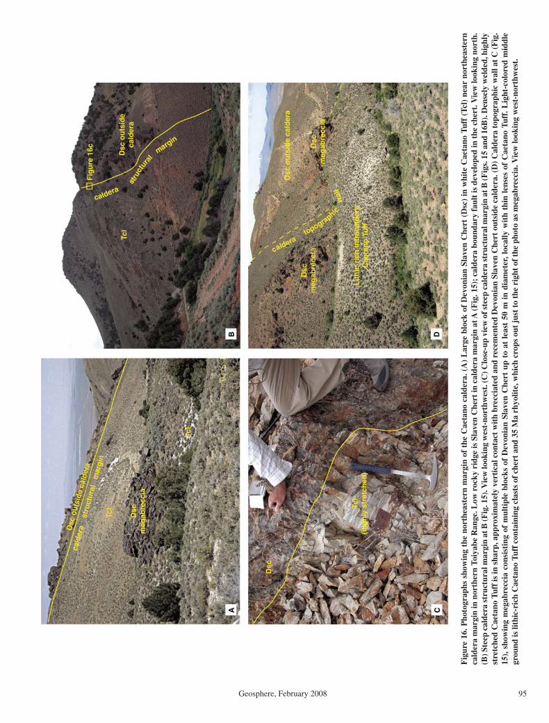
Magmatic and Tectonic Evolution of the Caetano caldera
Geosphere, February 2008 95
Fig
ure
16. P
hoto
grap
hs s
how
ing
the
nort
heas
tern
mar
gin
of t
he C
aeta
no c
alde
ra. (
A)
Lar
ge b
lock
of
Dev
onia
n Sl
aven
Che
rt (
Dsc
) in
whi
te C
aeta
no T
uff
(Tcl
) ne
ar n
orth
east
ern
cald
era
mar
gin
in n
orth
ern
Toiy
abe
Ran
ge. L
ow r
ocky
rid
ge is
Sla
ven
Che
rt in
cal
dera
mar
gin
at A
(F
ig. 1
5);
cald
era
boun
dary
fau
lt is
dev
elop
ed in
the
che
rt. V
iew
look
ing
nort
h.
(B) S
teep
cal
dera
str
uctu
ral m
argi
n at
B (F
ig. 1
5). V
iew
look
ing
wes
t-no
rthw
est.
(C) C
lose
-up
view
of s
teep
cal
dera
str
uctu
ral m
argi
n at
B (F
igs.
15
and
16B
). D
ense
ly w
elde
d, h
ighl
y st
retc
hed
Cae
tano
Tuf
f is
in s
harp
, app
roxi
mat
ely
vert
ical
con
tact
wit
h br
ecci
ated
and
rec
emen
ted
Dev
onia
n Sl
aven
Che
rt o
utsi
de c
alde
ra. (
D)
Cal
dera
top
ogra
phic
wal
l at
C (
Fig
. 15
), s
how
ing
meg
abre
ccia
con
sist
ing
of m
ulti
ple
bloc
ks o
f D
evon
ian
Slav
en C
hert
up
to a
t le
ast
50 m
in
diam
eter
, loc
ally
wit
h th
in l
ense
s of
Cae
tano
Tuf
f. L
ight
-col
ored
mid
dle
grou
nd is
lith
ic-r
ich
Cae
tano
Tuf
f co
ntai
ning
cla
sts
of c
hert
and
35
Ma
rhyo
lite,
whi
ch c
rops
out
jus
t to
the
rig
ht o
f th
e ph
oto
as m
egab
recc
ia. V
iew
look
ing
wes
t-no
rthw
est.
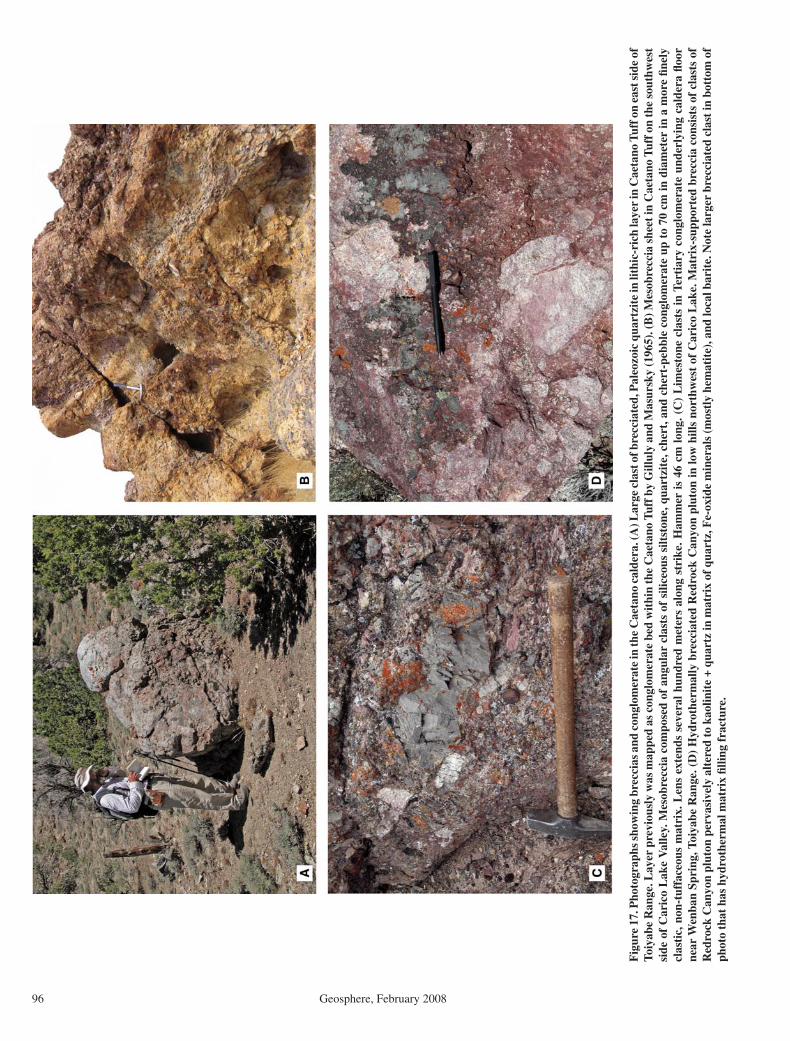
John et al.
96 Geosphere, February 2008
Fig
ure
17. P
hoto
grap
hs s
how
ing
brec
cias
and
con
glom
erat
e in
the
Cae
tano
cal
dera
. (A
) Lar
ge c
last
of b
recc
iate
d, P
aleo
zoic
qua
rtzi
te in
lith
ic-r
ich
laye
r in
Cae
tano
Tuf
f on
east
sid
e of
To
iyab
e R
ange
. Lay
er p
revi
ousl
y w
as m
appe
d as
con
glom
erat
e be
d w
ithi
n th
e C
aeta
no T
uff b
y G
illul
y an
d M
asur
sky
(196
5). (
B) M
esob
recc
ia s
heet
in C
aeta
no T
uff o
n th
e so
uthw
est
side
of
Car
ico
Lak
e V
alle
y. M
esob
recc
ia c
ompo
sed
of a
ngul
ar c
last
s of
sili
ceou
s si
ltst
one,
qua
rtzi
te, c
hert
, and
che
rt-p
ebbl
e co
nglo
mer
ate
up t
o 70
cm
in d
iam
eter
in a
mor
e fi n
ely
clas
tic,
non
-tuf
face
ous
mat
rix.
Len
s ex
tend
s se
vera
l hu
ndre
d m
eter
s al
ong
stri
ke. H
amm
er i
s 46
cm
lon
g. (
C)
Lim
esto
ne c
last
s in
Ter
tiar
y co
nglo
mer
ate
unde
rlyi
ng c
alde
ra fl
oor
ne
ar W
enba
n Sp
ring
, Toi
yabe
Ran
ge. (
D)
Hyd
roth
erm
ally
bre
ccia
ted
Red
rock
Can
yon
plut
on in
low
hill
s no
rthw
est
of C
aric
o L
ake.
Mat
rix-
supp
orte
d br
ecci
a co
nsis
ts o
f cl
asts
of
Red
rock
Can
yon
plut
on p
erva
sive
ly a
lter
ed to
kao
linit
e +
quar
tz in
mat
rix
of q
uart
z, F
e-ox
ide
min
eral
s (m
ostl
y he
mat
ite)
, and
loca
l bar
ite.
Not
e la
rger
bre
ccia
ted
clas
t in
bott
om o
f ph
oto
that
has
hyd
roth
erm
al m
atri
x fi l
ling
frac
ture
.

Magmatic and Tectonic Evolution of the Caetano caldera
Geosphere, February 2008 97
in Paleozoic rock. However, the four shown on Figure 15 are mostly to entirely surrounded by Caetano Tuff, and clasts of the rhyolite are common in adjacent lithic-rich tuff. As with the chert megabreccia, several of the rhyolite blocks are probably composite.
Gilluly and Masursky (1965) mapped mega-breccia and some mesobreccia as in-place Paleozoic Valmy Formation or Slaven Chert, depending on whether the blocks were quartzite or chert, or rhyolite dikes and other mesobrec-cia lenses as Tertiary conglomerate. However, the large size of clasts and their interbedding or interfi ngering with Caetano Tuff demonstrates that they are megabreccia and mesobreccia. The distinctive clast types are consistent with outcrops in the caldera wall north of the Cop-per Fault and in the Cortez Range to the east. We also found limestone clasts that are prob-ably derived from lower plate Wenban Forma-tion, which crops out below Tertiary gravel in the Cortez Range. Lower plate rocks are recog-nized in breccia only in the eastern part of the caldera. Rhyolite clasts are petrographically identical to the ca. 35 Ma rhyolite dikes in the Cortez Mine and a small rhyolite dome in the Cortez Range (Plate 1). The large, east-striking body at C (Fig. 15), which is probably com-posite, is one of the rhyolites dated by Wells et al. (1971).
Other Mesobreccia and Megabreccia Locations
Massive to layered mesobreccia or megabrec-cia crops out near the caldera margin in many locations. A notable occurrence is just west of Carico Lake Valley (Plate 1). Mesobreccia com-posed of angular clasts of siliceous siltstone, quartzite, chert, and chert-pebble conglomerate up to 70 cm in diameter in a more fi nely clastic, non-tuffaceous matrix is interbedded with prob-ably uppermost Caetano Tuff. Irregular bedding is defi ned by variations in clast type, size, and abundance (Fig. 17B). The mesobreccia layers form several thick sequences with minor inter-bedded Caetano Tuff; the entire mesobreccia sequence is at least 100 m thick.
Although most breccia is within 1–2 km of the caldera margin, at least one occurrence is more than 4 km from the nearest margin. Mesobreccia that crops out within the upper Caetano Tuff unit northeast of Red Mountain near Tub Spring (Plate 1) is the most distant from the caldera margin that we found. The breccia in this area contains blocks of chert up to 5 m long (Fig. 13D). This breccia was deposited very late during eruption and cal-dera collapse. The caldera margin may have had its greatest relief so that breccia could travel the farthest from the margin.
Upper Unit of Caetano Tuff near Tub Spring
The character of the upper unit of Caetano Tuff is best illustrated northwest of Tub Spring in the south-central part of the caldera, where the lower-upper contact is repeated by several northwest-striking, down-to-the-southwest faults (Plate 1; Fig. 8C). The simple, lower unit is composed of dark, densely welded tuff that forms few separable ledges and is locally capped by a dark vitrophyre. The composite upper unit is commonly light-col-ored to banded on air photos, with repeated poorly to densely welded sections and common sedimen-tary interbeds.
The base of the upper unit is marked variably by a vitrophyre or vitrophyre breccia presumably reworked from the lower unit or a clay-rich zone probably marking weathered formerly glassy, poorly welded tuff or tuffaceous sediment. This soft zone forms a distinct topographic break. At one location, vitrophyre breccia is overlain by a probable debris-fl ow deposit composed of angu-lar blocks of devitrifi ed Caetano Tuff up to 2 m in diameter. The breccia is overlain by well-bed-ded tuffaceous to pebbly coarse sandstone with abundant pumice, quartz, sanidine, quartzite, and chert up to 4 mm in diameter.
The rest of the upper unit consists of repeated, poorly welded, or zoned poorly to moderately to rarely densely welded tuffs that commonly con-tain abundant lithic fragments. Subangular frag-ments of densely to poorly welded Caetano Tuff up to 1.4 m in diameter are most common (Fig. 8D), but some tuffs are dominated by hornblende-pyroxene andesite and Paleozoic fragments up to 15 cm. Poorly to moderately welded tuff charac-terized by distinctive orange pumice fragments are common and locally interbedded with dark, densely welded tuff. “Orange-pumice tuff” is present in most other areas of the upper unit. Sedi-mentary interbeds of varied thickness separate the tuffs or sequences of tuffs. These deposits range from coarse conglomerate or debris fl ows to fi ne, platy tuffaceous siltstone. Conglomerates com-monly consist of a lag of angular to subrounded Caetano Tuff up to 1 m in diameter or chert peb-bles and cobbles in a clayey soil. Well-bedded coarse sandstone is common.
The change from lower to upper unit probably marks an abrupt change in eruption dynamics, from continuous to more sporadic eruption near the end of the caldera cycle. The more sporadic eruptions allowed greater cooling zonation and time for sediment deposition between ash fl ows. The sedimentary interbeds probably are later-ally equivalent to the thick, upper mesobrec-cias and megabreccias near the caldera margin at Red Mountain. Rock fall or rock avalanche deposits spalled from the margin probably were
reworked into debris-fl ow or fl uvial deposits far-ther from the margin.
Caldera Floor at Caetano Ranch
The caldera fl oor is exposed for ~4 km along strike in the footwall of the Caetano Ranch fault in the southeastern part of the caldera (Plate 1, Fig. 18). In this area, more than 3 km of intra-caldera Caetano Tuff overlies Tertiary andesite and conglomerate and Paleozoic quartzite, lime-stone, and chert-quartzite-pebble conglomerate. Paleozoic limestone and conglomerate crop out together in a large area in the footwall of the Caetano Ranch fault. The conglomerate has well-rounded pebbles up to 5 cm in diameter in a well-cemented, red-weathering, presumably ferruginous matrix (Fig. 4A). It is faintly to well bedded, strikes east, and dips variably north and south. The massive limestone did not yield con-odonts (A.G. Harris, 2007, written commun.), but we infer that it and conglomerate are prob-ably part of the Pennsylvanian-Permian Antler sequence, which crops out in several areas south and northeast of the Caetano caldera, including in the Cortez Range ~20 km to the northeast (Gilluly and Masursky, 1965) and The Cedars area (Moore et al., 2000). Quartzite, which crops out north of the area shown in Figure 18, is probably part of the Valmy Formation in the upper plate of the Roberts Mountains thrust (Gilluly and Masursky, 1965).
Tertiary conglomerate crops out beneath the caldera fi ll in the southern part of Figure 18. It dips ~40° east, together with the overlying andesite and Caetano Tuff, consistent with no deformation between deposition of the gravel and eruption of tuff. The gravel is faulted against Caetano Tuff and post-tuff sedimentary rocks to the west. The conglomerate contains angu-lar to moderately rounded clasts of limestone to 70-cm-long and lesser chert and quartzite in a calcite-cemented matrix (Fig. 17C). Conodonts from a limestone clast are long-ranging mor-photypes that span the Silurian to the Mississip-pian (A.G. Harris, 2007, written commun.) and are consistent with Lower Paleozoic limestone from the lower plate of the Roberts Mountains allochthon, probably the Devonian Wenban Limestone exposed in the nearby Cortez Range. The lithologic and structural differences dem-onstrate that this conglomerate is not the same unit as the Paleozoic conglomerate.
Finely porphyritic, andesite lava containing plagioclase, pyroxene, and lesser hornblende phenocrysts overlies pre-volcanic conglomer-ate or Paleozoic rocks. The andesite reaches a maximum thickness of 300–400 m where it overlies limestone and chert-quartzite-pebble conglomerate and thins to the north and south.

John et al.
98 Geosphere, February 2008
Approximately 15 m of andesite separates pre-volcanic conglomerate from Caetano Tuff in the south. Just north of Figure 18, a thin layer of andesite appears to have fi lled in and smoothed over irregular topography on Valmy quartzite (Plate 1).
The Caetano Tuff in the Toiyabe Range has a basal vitrophyre and also has several intratuff vitrophyres, an unusual feature for a thick intr-acaldera tuff. In other respects, it is similar to Caetano Tuff throughout the caldera. For exam-ple, Mount Caetano consists of more than 1000
m of monotonous, densely welded, devitrifi ed ash-fl ow tuff (Fig. 7A). In contrast, the upper Caetano Tuff, which is well preserved on the downthrown side of the Caetano Ranch Fault, varies from densely to poorly welded and devit-rifi ed to glassy. This suggests more sporadic
Figure 18. Geologic map of the caldera fl oor and intracaldera Caetano Tuff near Caetano Ranch (Wenban Spring 7-½' quadrangle). The caldera fl oor, which is exposed for ~4 km along strike, consists of Permian-Pennsylvanian Antler overlap sequence limestone and conglom-erate (Fig. 4A), overlain by andesite lavas. The lower unit of intracaldera Caetano Tuff, as much as 3.6 km thick, overlies the pre-caldera rocks. The upper unit of Caetano Tuff including mesobreccia crops out on the downthrown side of the middle Miocene Caetano Ranch Fault. Paleozoic Valmy Formation south of the Wenban Fault constitutes the southern caldera wall.

Magmatic and Tectonic Evolution of the Caetano caldera
Geosphere, February 2008 99
Tcbx
Tcbx
Tcs
Tbb
Tbc
9090
8275
75
33
17
30
0 1 km
Qp
Tci
Tci
Tci
Tci
Qf
Qf
Qal
Tcl
Tcl
Tcbx
116°52'42"
40°7'56"
Playa, alluviumQp
Qf
Qf TbcTbc
TbbTbb
TcsTcs
TcsTci TcbxTcbx
Tcl
Fan
C unit
Qal
B unit
Post-Caetano sediments
Tci = Carico Lake intrusionTcbx = Breccia
Caetano Tuff
Bates Mountain Tuff
N
Figure 19. Geologic map of Carico Lake pluton, a resurgent intrusion of granite porphyry that intruded and steeply tilted Caetano Tuff near the middle of the caldera (Carico Lake North and Rocky Pass 7-½' quadrangles). A breccia composed of coarse blocks of Caetano Tuff (Tcbx) probably formed by gravitational sliding of steeply tilted and uplifted tuff over the intrusion. The B and C units of the Bates Mountain Tuff show the normal, moderate, east dip resulting from middle Miocene extension (Colgan et al., 2008.
eruptions during the waning stages of Caetano eruption. Mesobreccia with clasts of Caetano Tuff, andesite, quartzite, chert-quartzite-pebble conglomerate, and marble up to 2.5 m in diam-eter overlie the upper unit tuff. Fine, tuffaceous sedimentary rocks that may be moat sediments overlie the mesobreccia.
Resurgent Intrusion
The Carico Lake pluton, a granite porphyry similar in phenocryst assemblage, composi-tion, and age to Caetano Tuff, crops out in a series of low hills surrounded by Quater-nary deposits in Carico Lake Valley (Plate 1) and probably underlies an area of at least 25 km2. The intrusion is distinguished from surrounding tuff by being generally massive and locally fl ow banded (Fig. 7D), by lack-ing ash-fl ow tuff features such as pumice, by being more coarsely porphyritic with pheno-crysts of sanidine to 2 cm, and by having a fi ne-grained, holocrystalline groundmass. Although the contact with tuff is nowhere
exposed, fi eld relations along part of the southern margin of the intrusion show that the granite intruded, domed, and brecciated the surrounding Caetano Tuff (Fig. 19).
The Carico Lake pluton crops out at the north end of irregular ridges east of Carico Lake and in several low hills to the northeast (Fig. 19). The southern and western parts of the ridges consist of Caetano Tuff that strikes anomalously east and has a near vertical dip. In the northern and eastern parts of the ridge, Caetano Tuff is overlain by a breccia composed of angular clasts of Caetano Tuff up to at least 5 m in diameter in a matrix of fi nely ground tuff. The breccia is overlain by clastic sedimentary rocks and the 30.5 Ma “B” and 28.8 Ma “C” units of the Bates Mountain Tuff (Table 1), which, unlike the underlying Caetano Tuff, have typical north strikes and moderate east dips (Fig. 19).
We interpret these relations to indicate that the pluton domed the Caetano Tuff, generat-ing the anomalous east strike and steep dips. Removing tilting from middle Miocene exten-sion would not signifi cantly change the anoma-
lous strikes, because Miocene extensional tilting was approximately parallel to the anomalous strike. The breccia resulted from gravitational sliding of steeply tilted and uplifted Caetano Tuff over the dome. Similar breccia is recog-nized around ca. 24 Ma felsic domes in western Nevada (Faulds et al., 2003; Henry et al., 2004). The overlying, undomed sedimentary rocks and ash-fl ow tuff then fi lled in over and around the dome and breccia. Intrusion, doming, and brec-ciation probably occurred within ca. 100,000 yr of ash-fl ow eruption and caldera collapse, given the indistinguishable ages of the intrusion and the Caetano Tuff, and had to have occurred before 30.5 Ma, the age of the “B” unit of Bates Mountain Tuff.
Pre-Caldera Paleovalley
Pre-Caetano Tuff sedimentary and volcanic deposits crop out east (southwestern Cortez Range) and west (east side of the Fish Creek Mountains) of the caldera, and underlie the cal-dera fl oor in the northern Toiyabe Range (Plate
John et al.
100 Geosphere, February 2008
1). Thin Tertiary basalt fl ows overlain by the tuff of Cove Mine form the caldera fl oor southwest of Wilson Pass and probably fi lled pre-caldera paleotopography (Fig. 14). We infer that these sedimentary and volcanic rocks were deposited in a west-trending paleovalley that may have been laterally continuous with the Golconda Canyon paleovalley 40 km to the west in the Tobin Range (Fig. 2; Gonsior, 2006; Gonsior and Dilles, 2008). The base of the Golconda Canyon paleovalley also was fi lled with Tertiary basalt fl ows that were, in turn, overlain by as much as 250 m of outfl ow Caetano Tuff, while the eastern part of the paleovalley was buried when the caldera collapsed.
In the southwestern Cortez Range, a thick sequence of poorly exposed gravel overlies both upper and lower plate rocks of the Roberts Mountains allochthon and is overlain by middle Miocene basaltic andesite fl ows (Plate 1; Gilluly and Masursky, 1965; Stewart and Carlson, 1976). These poorly sorted and poorly lithifi ed depos-its are ≥400 m thick and contain blocks of both upper and lower plate Paleozoic rocks, granitic rocks, porphyritic andesites, fl ow-banded rhyo-lites, Caetano Tuff, and younger tuffs including units A(?), B, and D of the Bates Mountain Tuff. Blocks in the gravels are as much as 10 m across, and concentrations of monolithologic blocks form hilltops and ridgelines as much as 200 m long. The presence of clasts of unit D of the Bates Mountain Tuff indicates a maximum age of ca. 25.3 Ma for parts of these deposits. However, sanidine phe-nocrysts from a waterlain, air-fall tuff yielded an 40Ar/39Ar age of 33.97 ± 0.20 Ma (Table 1), sug-gesting that parts of the gravels are at least this old. We interpret this tuff as an ash fall related to eruption of the Caetano Tuff and infer that these gravels were deposited in a long-lived paleovalley that had been incised into the lower plate of the Roberts Mountains allochthon prior to eruption of the Caetano Tuff.
Tertiary conglomerates that underlie the Caetano caldera are exposed on both sides of the northern Toiyabe Range (Plate 1). Several hundred meters of strongly lithifi ed calcareous sandstone and pebbly conglomerate containing abundant Paleozoic limestone clasts crop out near Wenban Spring (see description of Caldera fl oor at Caetano Ranch). Poorly exposed, locally well-lithifi ed conglomerate also underlies intra-caldera Caetano Tuff on the northwestern edge of the Toiyabe Range. This conglomerate con-tains subrounded clasts of quartzite, chert, argil-lite, granite, diorite, and several textural types of rhyolite as much as 1.5 m in diameter in a sandy noncalcareous matrix (Fig. 4B).
Tuffaceous sedimentary rocks interbedded with andesite and dacite fl ows form the basal Tertiary deposits and underlie outfl ow Caetano
Tuff in Horseshoe Basin on the northeast side of the Fish Creek Mountains (Fig. 2; Stewart and McKee, 1977).
We interpret that these pre-Caetano Tuff sedi-mentary and volcanic deposits fi lled a paleoval-ley at least 400 m deep that drained west from the southern Cortez Range across the Tobin Range (Fig. 2). Most of the paleovalley corresponds to the volcano-tectonic trough of Masursky (1960) and Burke and McKee (1979). However, our interpretation of the origin of this paleovalley differs from previous workers, as discussed in a later section. The paleovalley was disrupted by formation of the Caetano and Fish Creek Mountains calderas, although sediments and tuffs continued to be deposited within the Caetano cal-dera throughout the lifetime of the paleovalley as shown by the ages of tuffs deposited in the Caetano caldera and in Golconda Canyon and present as clasts in the gravels in the Cortez Range. Unit D of the Bates Mountain Tuff at 25.27 Ma is the youngest recognizable clast in the gravel deposits in the Cortez Range and youngest tuff inside the Caetano caldera, and drainage across the Caetano caldera may have been permanently disrupted by formation of the Fish Creek Mountains caldera at 24.72 Ma (Table 1; McKee, 1970).
Hydrothermal Alteration in the Caetano Caldera
Intracaldera Caetano Tuff is hydrothermally altered along the entire north-south extent of the caldera from Elephant Head north to Wil-son Pass, and along the southern caldera margin from the Shoshone Range to southwest Crescent Valley (Plate 1). Alteration of the Caetano Tuff generally is absent on the north side of Carico Lake Valley, at Rocky Pass, and in the north-ern Toiyabe Range. The Carico Lake pluton is unaltered to very weakly altered and forms the northeast boundary of alteration. In contrast, the Redrock Canyon pluton is pervasively altered.
Three major, hydrothermal alteration assem-blages are recognized: (1) vuggy silica, (2) advanced argillic, and (3) intermediate argillic. In vuggy silica alteration, both plagioclase and K-feldspar phenocrysts are leached leaving promi-nent voids, and the groundmass is replaced by fi ne-grained silica with several percent dissemi-nated, fi ne-grained pyrite that is mostly oxidized. Vuggy silica alteration is transitional to advanced argillic alteration that consists of a kaolinite-quartz ± pyrite assemblage in which both plagio-clase and sanidine phenocrysts are replaced by kaolinite, biotite is altered to kaolinite or opaque oxide minerals, and the groundmass is replaced by kaolinite and fi ne-grained silica. Minor alunite is present locally. Most advanced argillic alteration is oxidized, but relict, disseminated, fi ne-grained
pyrite is present locally. In many rocks, abundant hematite is present. Advanced argillic alteration is transitional to intermediate argillic alteration in which fi ne-grained kaolinite replaces plagioclase phenocrysts, and sanidine phenocrysts are gener-ally unaltered or are perthitic. Biotite phenocrysts are variably replaced by opaque oxides, white mica, or are relatively unaltered. Groundmass is altered to a mixture of fi ne-grained silica and kaolinite. Narrow (<5-cm-wide) quartz ± pyrite veins are present locally in zones of vuggy silica and advanced argillic alteration, notably along the south margin of the caldera on both sides of Carico Lake Valley, and thin sedimentary beds are locally silicifi ed in the upper Caetano unit (Fig. 8B), but no major zones of quartz veining or silicifi cation were recognized. Hydrothermal breccias cemented with quartz, Fe-oxides, and barite were recognized in the Redrock Canyon pluton on the northwest side of Carico Lake (Fig. 17D). In general, alteration is most intense along the south caldera margin on both sides of Carico Lake Valley, and in the west-central part of the caldera in and around the Redrock Canyon plu-ton between Redrock Canyon and Carico Lake Valley (Plate 1).
Although strong hydrothermal alteration affects intracaldera Caetano Tuff, overlying sedimentary rocks and the Bates Mountain Tuff are unaltered. The Redrock Canyon pluton is strongly altered to argillic and advanced argillic assemblages simi-lar to alteration in the surrounding Caetano Tuff. In contrast, the Carico Lake pluton is unaltered, intracaldera Caetano Tuff along the north and east sides of the pluton are generally unaltered and locally vitrophyric, and altered Caetano Tuff is generally absent farther east inside the caldera. These relations suggest that hydrothermal altera-tion of the Caetano caldera is related to emplace-ment of the Redrock Canyon pluton in the west-central part of the caldera shortly after eruption of the Caetano Tuff and caldera collapse. We infer that emplacement of the Carico Lake pluton post-dates alteration.
Widespread, advanced argillic alteration, such as in the Caetano caldera, is uncommon in ash-fl ow calderas elsewhere, where propy-litic and/or argillic alteration are more typical (e.g., Lipman, 1984; John and Pickthorn, 1996). Alteration in the Caetano caldera more closely resembles shallow magmatic-hydrothermal alteration in porphyry systems formed by degas-sing of shallowly emplaced, sulfur-rich magmas, although the presence of hypogene(?) hematite and only sparse alunite suggests that the Caetano hydrothermal fl uids were relatively sulfur poor. We attribute the abundance of advanced argil-lic alteration in the Caetano caldera to the very shallow emplacement (<1 km) of the Redrock Canyon pluton into water-saturated, interbedded
Magmatic and Tectonic Evolution of the Caetano caldera
Geosphere, February 2008 101
poorly welded tuff and sedimentary rocks of the upper Caetano Tuff unit. The large volume of altered rock likely indicates that the entire west half of the Caetano caldera is underlain by intru-sive rocks at shallow depths.
DISCUSSION
Distribution, Volume, and Source of the Caetano Tuff and Tuff of Cove Mine
Petrologic, geochemical, and geochronologic data presented above show that the previously identifi ed Caetano Tuff consists of two distinct ash-fl ow tuffs, the ca. 33.8 Ma Caetano Tuff and the older (ca. 34.2 Ma), more mafi c tuff of Cove Mine. The spatial distribution of these tuffs is shown in Figure 2. The tuff of Cove Mine is lim-ited to scattered exposures on the north side of the Caetano caldera that extend ~40 km north from the caldera to just south of the town of Battle Mountain. Most of the Caetano Tuff is exposed within the structurally dismembered Caetano caldera, but outfl ow tuff from the cal-dera is exposed in the Tobin Range, 40 km west of the caldera and in the Toiyabe Range near Cowboy Rest Creek, ~30 km south of the cal-dera (Fig. 1). Coarse blocks of Caetano Tuff also are present in the gravel deposits immediately east of the caldera in the southwestern Cortez Range, although no outfl ow Caetano Tuff has been found east of the caldera.
The volume of intracaldera Caetano Tuff is crudely estimated at ≥840 km3 using a restored area of ~280 km2 for the outline of the caldera after removing 100% post-caldera extension (Colgan et al., 2008) and an average thickness of 3 km for intracaldera Caetano Tuff. Intra-caldera tuff thickness is based on an exposed thickness of >3.4 km in the northeast part of the caldera and ~2.0 km for the northwest part of the caldera. The volume of preserved extracal-dera Caetano Tuff to the south and west sides of the caldera is diffi cult to estimate but is proba-bly small. However, the 1 km excess of collapse over intracaldera tuff suggests that an additional ~280 km3 probably erupted as outfl ow tuff that was subsequently eroded or as widely dispersed pyroclastic-fall tuff. Therefore, a conservative minimum estimate of the total erupted volume of Caetano Tuff is ~1100 km3.
The source of the Caetano Tuff has long been inferred to be in the northern Toiyabe Range or Shoshone Range, which have been vari-ably described as a volcano-tectonic trough or depression (Masursky, 1960; Gilluly and Masur-sky, 1965; Stewart and McKee, 1977; Burke and McKee, 1979) or as one (Best et al., 1989; McKee and Moring, 1996) or two (Ludington et al., 1996) calderas on small-scale regional
maps. As demonstrated by the distribution of the Caetano Tuff, the great thickness of intracaldera tuff, and the presence of cogenetic age-equiva-lent intrusions in the center of the caldera, our study conclusively proves that the Caetano cal-dera is the source of the Caetano Tuff.
The source of the tuff of Cove Mine is unknown but seems likely to be within its known distribution. It is thickest in the northern Fish Creek Mountains, suggesting a source may be buried beneath the ca. 24.7 Ma Fish Creek Mountains caldera or beneath younger sediment in a nearby valley. Burial beneath the Caetano caldera is precluded by absence of the tuff of Cove Mine in exposures of the caldera fl oor in the Toiyabe Range and by its presence only as a thin (50–100 m) outfl ow sheet on the caldera fl oor at Wilson Pass.
Wrucke and Silberman (1975) proposed a cal-dera at Mount Lewis for the entire Caetano Tuff at a time when the tuff’s dual nature and source were not recognized (Fig. 2). However, even the existence of a caldera at this location is highly controversial (Gilluly, 1977; Wrucke and Silber-man, 1977). Wrucke and Silberman (1975) cite numerous K-Ar ages that show that volcanic and intrusive rocks within their proposed caldera are similar in age to the Caetano Tuff. However, most outcrop within the proposed caldera con-sists of Paleozoic rocks, and the Caetano Tuff is absent within the caldera. This requires that any intracaldera Caetano Tuff be completely eroded, leaving only numerous, small intrusions and odd, locally derived volcanic breccias. No other known or proposed caldera in Nevada has been completely stripped of its intracaldera tuff (Best et al., 1989; Boden, 1992; John, 1995; Henry et al., 1999). Thus, the source of the tuff of Cove Mine remains unknown.
Caetano Caldera Evolution
Miocene extensional faulting and tilting has exposed the interior of the Caetano caldera over a paleodepth range of >5 km, from beneath the caldera fl oor through post-caldera sediments, providing constraints on an evolutionary model of the Caetano caldera that are rarely avail-able for other calderas (Fig. 20). In this paper, we present a model for the formation of the Caetano caldera that is based on the extensive fi eld observations and analytical data discussed in earlier sections.
The Caetano caldera formed over an area of relatively low relief developed on Paleo-zoic rocks and incised by a broad, west-trend-ing paleovalley locally fi lled with at least 400 m of gravel and conglomerate (Fig. 20A). The lack of pre-Caetano faults, angular unconformi-ties, or sedimentary basins are consistent with
the region not undergoing extension before the middle Miocene (Colgan et al., 2008). The pres-ence of lower-plate limestone clasts in strongly lithifi ed, pre-Caetano Tuff conglomerate in the Toiyabe Range indicates that the paleovalley had cut down through the <1-km-thick, upper plate of the Roberts Mountains allochthon prior to eruption of the Caetano Tuff.
Volcanic activity in the area immediately pre-ceding formation of the Caetano caldera was minor; the caldera did not form over a precursor volcano. Rhyolite dikes and small domes exposed near the northeast margin of the caldera (Gilluly and Masursky, 1965) are ca. 1.5 Ma older than the caldera (Wells et al., 1971; Mortensen et al., 2000) but might represent early activity related to the caldera-forming magma. A large rhyolite center is exposed in the Simpson Park Range, ~12 km southeast of the caldera (volcanics of Fye Canyon; Gilluly and Masursky, 1965), but these silicic lavas also are ca. 1–1.5 Ma older than the Caetano caldera (K-Ar ages of 34.8 ± 1.0 and 35.4 ± 1.0 Ma; McKee and Conrad, 1994). Thin, undated andesite/basalt fl ows fi ll local topographic depressions below the caldera fl oor in the northern Toiyabe Range and west of Wilson Pass in the Shoshone Range, and more extensive andesite/dacite fl ows are interbedded with sedimentary rocks west of the caldera on the east side of the Fish Creek Mountains. The sources of these lavas are unknown. Outfl ow tuff of Cove Mine locally fi lled paleotopogra-phy, mostly north of the Caetano caldera, and locally overlies thin basalt fl ows southwest of Wilson Pass within the caldera.
Formation of the Caetano caldera began with eruption of the lower unit of the Caetano Tuff and collapse along steep, caldera-bound-ing faults at ca. 33.8 Ma (Fig. 20B). Outfl ow Caetano Tuff fl owed primarily to the west and south of the caldera, locally fi lling the west-trending paleovalley that drained the area over-lying the caldera. The lower unit of intracaldera Caetano Tuff apparently forms a single, com-pound cooling unit as much as 3600 m thick. A prominent 10- to 20-m-thick basal vitrophyre is preserved in the eastern part of the caldera that was not affected by hydrothermal alteration. Several other vitrophyric layers are preserved in the northern Toiyabe Range; these vitro-phyres represent quench zones around lithic-rich layers within the tuff rather than marking cooling breaks between ash fl ows. The lower unit is normally zoned compositionally from high-silica rhyolite at the base to low-silica rhyolite at the top.
Caldera collapse was asymmetric, with greater amounts of collapse and thicker caldera fi ll in the eastern part of the caldera. Total col-lapse was as much as 5 km in the eastern part

John et al.
102 Geosphere, February 2008
3
2
1
0
3
2
1
0
0
1
2
3
4
5
6
7
0
1
2
3
4
5
6
7
0
1
2
3
4
5
6
7
0
1
2
3
4
5
6
7
0
1
2
3
4
5
6
7
0
1
2
3
4
5
6
7
Upper Caetano Tuff
Carico Lake pluton
Redrock Canyon pluton
Bates Mountain Tuff
Post-caldera sediments
Granite/granodiorite
Ring-fracture intrusion
Lower Caetano Tuff
Andesite
Gravel and conglomerate
Paleozoic rocks, undivided
Hydrothermal alteration
Megabreccia
Mesobreccia
A
B
C
D
N S
Kilo
met
ers
Kilo
met
ers
Kilo
met
ers
Kilo
met
ers
34 Ma
33.8 Ma
33.7 Ma
25 Ma
???
???
Figure 20. Cartoon model showing evolution of the Caetano caldera. Sections are ~N-S through the center of the caldera. No vertical exaggeration. (A) ca. 34 Ma shortly before caldera formation. Caldera site underlain by irregular erosional surface on Paleozoic rocks locally cut by Tertiary paleovalleys, partly fi lled with gravels and andesite lava fl ows. (B) 33.8 Ma following eruption of the thick lower unit of Caetano Tuff, caldera collapse with megabreccia blocks and meso-breccia lenses shed into the caldera, and eruption of the much thinner upper unit of Caetano Tuff. Caldera collapse was signifi -cantly greater in the eastern part of the cal-dera than in the western part. (C) 33.7 Ma following intrusion of the Carico Lake and Redrock Canyon plutons, resurgent dom-ing around Carico Lake pluton, shedding of breccias off the resurgent dome, circulation of hydrothermal fl uids and extensive hydro-thermal alteration in western part of caldera probably related to the Redrock Canyon intrusion, and emplacement of small, ring-fracture intrusion; (D) 25.3 Ma following a long period of deposition of sediments and distal outfl ow tuffs (mostly Bates Mountain Tuffs) in caldera depression. Early sedi-ments may have been lacustrine and depos-ited in a moat around the resurgent dome. Later sediments are mostly fl uvial.
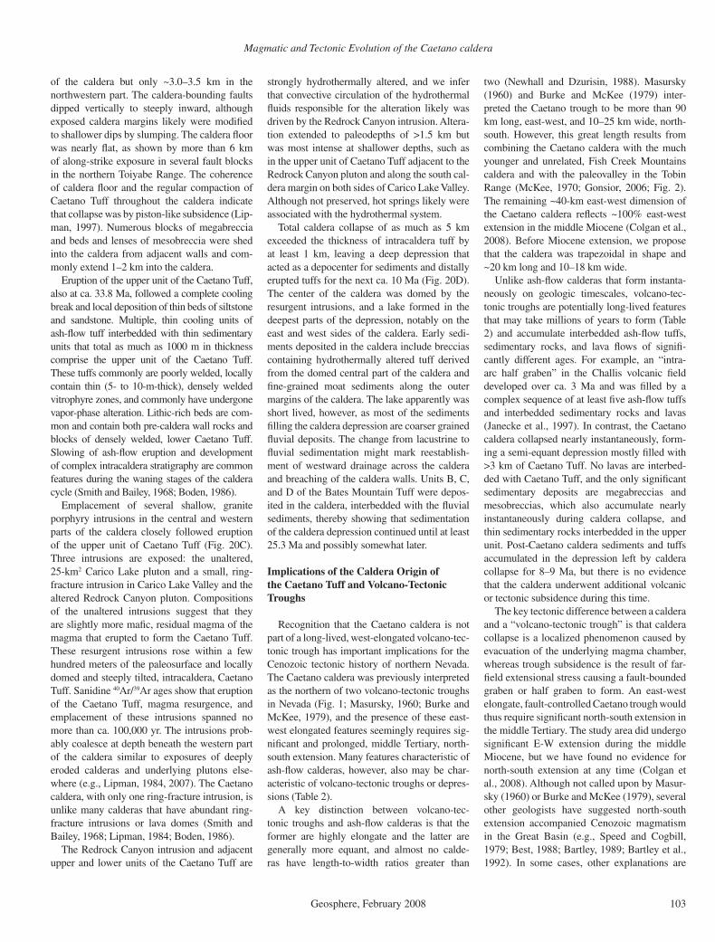
Magmatic and Tectonic Evolution of the Caetano caldera
Geosphere, February 2008 103
of the caldera but only ~3.0–3.5 km in the northwestern part. The caldera-bounding faults dipped vertically to steeply inward, although exposed caldera margins likely were modifi ed to shallower dips by slumping. The caldera fl oor was nearly fl at, as shown by more than 6 km of along-strike exposure in several fault blocks in the northern Toiyabe Range. The coherence of caldera fl oor and the regular compaction of Caetano Tuff throughout the caldera indicate that collapse was by piston-like subsidence (Lip-man, 1997). Numerous blocks of megabreccia and beds and lenses of mesobreccia were shed into the caldera from adjacent walls and com-monly extend 1–2 km into the caldera.
Eruption of the upper unit of the Caetano Tuff, also at ca. 33.8 Ma, followed a complete cooling break and local deposition of thin beds of siltstone and sandstone. Multiple, thin cooling units of ash-fl ow tuff interbedded with thin sedimentary units that total as much as 1000 m in thickness comprise the upper unit of the Caetano Tuff. These tuffs commonly are poorly welded, locally contain thin (5- to 10-m-thick), densely welded vitrophyre zones, and commonly have undergone vapor-phase alteration. Lithic-rich beds are com-mon and contain both pre-caldera wall rocks and blocks of densely welded, lower Caetano Tuff. Slowing of ash-fl ow eruption and development of complex intracaldera stratigraphy are common features during the waning stages of the caldera cycle (Smith and Bailey, 1968; Boden, 1986).
Emplacement of several shallow, granite porphyry intrusions in the central and western parts of the caldera closely followed eruption of the upper unit of Caetano Tuff (Fig. 20C). Three intrusions are exposed: the unaltered, 25-km2 Carico Lake pluton and a small, ring-fracture intrusion in Carico Lake Valley and the altered Redrock Canyon pluton. Compositions of the unaltered intrusions suggest that they are slightly more mafi c, residual magma of the magma that erupted to form the Caetano Tuff. These resurgent intrusions rose within a few hundred meters of the paleosurface and locally domed and steeply tilted, intracaldera, Caetano Tuff. Sanidine 40Ar/39Ar ages show that eruption of the Caetano Tuff, magma resurgence, and emplacement of these intrusions spanned no more than ca. 100,000 yr. The intrusions prob-ably coalesce at depth beneath the western part of the caldera similar to exposures of deeply eroded calderas and underlying plutons else-where (e.g., Lipman, 1984, 2007). The Caetano caldera, with only one ring-fracture intrusion, is unlike many calderas that have abundant ring-fracture intrusions or lava domes (Smith and Bailey, 1968; Lipman, 1984; Boden, 1986).
The Redrock Canyon intrusion and adjacent upper and lower units of the Caetano Tuff are
strongly hydrothermally altered, and we infer that convective circulation of the hydrothermal fl uids responsible for the alteration likely was driven by the Redrock Canyon intrusion. Altera-tion extended to paleodepths of >1.5 km but was most intense at shallower depths, such as in the upper unit of Caetano Tuff adjacent to the Redrock Canyon pluton and along the south cal-dera margin on both sides of Carico Lake Valley. Although not preserved, hot springs likely were associated with the hydrothermal system.
Total caldera collapse of as much as 5 km exceeded the thickness of intracaldera tuff by at least 1 km, leaving a deep depression that acted as a depocenter for sediments and distally erupted tuffs for the next ca. 10 Ma (Fig. 20D). The center of the caldera was domed by the resurgent intrusions, and a lake formed in the deepest parts of the depression, notably on the east and west sides of the caldera. Early sedi-ments deposited in the caldera include breccias containing hydrothermally altered tuff derived from the domed central part of the caldera and fi ne-grained moat sediments along the outer margins of the caldera. The lake apparently was short lived, however, as most of the sediments fi lling the caldera depression are coarser grained fl uvial deposits. The change from lacustrine to fl uvial sedimentation might mark reestablish-ment of westward drainage across the caldera and breaching of the caldera walls. Units B, C, and D of the Bates Mountain Tuff were depos-ited in the caldera, interbedded with the fl uvial sediments, thereby showing that sedimentation of the caldera depression continued until at least 25.3 Ma and possibly somewhat later.
Implications of the Caldera Origin of the Caetano Tuff and Volcano-Tectonic Troughs
Recognition that the Caetano caldera is not part of a long-lived, west-elongated volcano-tec-tonic trough has important implications for the Cenozoic tectonic history of northern Nevada. The Caetano caldera was previously interpreted as the northern of two volcano-tectonic troughs in Nevada (Fig. 1; Masursky, 1960; Burke and McKee, 1979), and the presence of these east-west elongated features seemingly requires sig-nifi cant and prolonged, middle Tertiary, north-south extension. Many features characteristic of ash-fl ow calderas, however, also may be char-acteristic of volcano-tectonic troughs or depres-sions (Table 2).
A key distinction between volcano-tec-tonic troughs and ash-fl ow calderas is that the former are highly elongate and the latter are generally more equant, and almost no calde-ras have length-to-width ratios greater than
two (Newhall and Dzurisin, 1988). Masursky (1960) and Burke and McKee (1979) inter-preted the Caetano trough to be more than 90 km long, east-west, and 10–25 km wide, north-south. However, this great length results from combining the Caetano caldera with the much younger and unrelated, Fish Creek Mountains caldera and with the paleovalley in the Tobin Range (McKee, 1970; Gonsior, 2006; Fig. 2). The remaining ~40-km east-west dimension of the Caetano caldera refl ects ~100% east-west extension in the middle Miocene (Colgan et al., 2008). Before Miocene extension, we propose that the caldera was trapezoidal in shape and ~20 km long and 10–18 km wide.
Unlike ash-fl ow calderas that form instanta-neously on geologic timescales, volcano-tec-tonic troughs are potentially long-lived features that may take millions of years to form (Table 2) and accumulate interbedded ash-fl ow tuffs, sedimentary rocks, and lava fl ows of signifi -cantly different ages. For example, an “intra-arc half graben” in the Challis volcanic fi eld developed over ca. 3 Ma and was fi lled by a complex sequence of at least fi ve ash-fl ow tuffs and interbedded sedimentary rocks and lavas (Janecke et al., 1997). In contrast, the Caetano caldera collapsed nearly instantaneously, form-ing a semi-equant depression mostly fi lled with >3 km of Caetano Tuff. No lavas are interbed-ded with Caetano Tuff, and the only signifi cant sedimentary deposits are megabreccias and mesobreccias, which also accumulate nearly instantaneously during caldera collapse, and thin sedimentary rocks interbedded in the upper unit. Post-Caetano caldera sediments and tuffs accumulated in the depression left by caldera collapse for 8–9 Ma, but there is no evidence that the caldera underwent additional volcanic or tectonic subsidence during this time.
The key tectonic difference between a caldera and a “volcano-tectonic trough” is that caldera collapse is a localized phenomenon caused by evacuation of the underlying magma chamber, whereas trough subsidence is the result of far-fi eld extensional stress causing a fault-bounded graben or half graben to form. An east-west elongate, fault-controlled Caetano trough would thus require signifi cant north-south extension in the middle Tertiary. The study area did undergo signifi cant E-W extension during the middle Miocene, but we have found no evidence for north-south extension at any time (Colgan et al., 2008). Although not called upon by Masur-sky (1960) or Burke and McKee (1979), several other geologists have suggested north-south extension accompanied Cenozoic magmatism in the Great Basin (e.g., Speed and Cogbill, 1979; Best, 1988; Bartley, 1989; Bartley et al., 1992). In some cases, other explanations are
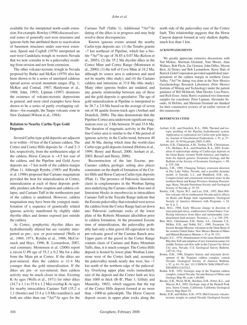
John et al.
104 Geosphere, February 2008
available for the interpreted north-south exten-sion. For example, Rowley (1998) discussed sev-eral zones of generally east-west structures and igneous belts but attributed them to reactivation of basement structures under east-west exten-sion. Speed and Cogbill (1979) interpreted an east-west Candelaria trough in western Nevada that we now consider to be a paleovalley result-ing from erosion and not from extension.
The other volcano-tectonic trough in Nevada proposed by Burke and McKee (1979) also has been shown to be a series of unrelated calderas spread across several mountain ranges (Fig. 1; McKee and Conrad, 1987; Hardyman et al., 1988; John, 1995). Lipman (1997) dismisses the existence of volcano-tectonic depressions in general, and most cited examples have been shown to be a series of partly overlapping cal-deras—for example, the Taupo volcanic zone in New Zealand (Wilson et al., 1984).
Relation to Nearby Carlin-Type Gold Deposits
Several Carlin-type gold deposits are adjacent to or within ~10 km of the Caetano caldera. The Cortez and Cortez Hills deposits lie ~5 and 2–3 km, respectively, from the northeastern edge of the caldera, Horse Canyon is ~4.5 km east of the caldera, and the Pipeline and Gold Acres deposits are ~7 km north of the caldera margin (Plate 1). Although Rytuba (1985) and Rytuba et al. (1986) proposed that Caetano magmatism provided the heat for mineralization at Cortez, mineralization at each of these deposits prob-ably predates ash-fl ow eruption and caldera col-lapse, and Caetano Tuff in the northeastern part of the caldera is unaltered. However, caldera magmatism may have been the youngest mani-festation of a sequence of genetically related igneous activity manifested by slightly older rhyolite dikes and domes exposed just outside the caldera.
At Cortez, porphyritic rhyolite dikes are hydrothermally altered but are variably inter-preted as pre-, syn- or post-mineral (Wells et al., 1969, 1971; Rytuba et al., 1986; McCor-mack and Hays, 1996; R. Leonardson, 2007, oral commun). Mortensen et al. (2000) report a zircon U-Pb age of 35.2 ± 0.2 Ma for a dike from the Main pit at Cortez. If the dikes are post-mineral, then the caldera is ≥1.4 Ma younger than the gold mineralization. If the dikes are pre- or syn-mineral, then caldera activity may be much closer in time. Existing K-Ar ages (Wells et al., 1971) for other dikes (34.7 ± 1.1 to 35.8 ± 1.2 Ma) overlap K-Ar ages for nearby intracaldera Caetano Tuff (35.2 ± 1.1 (biotite) and 33.4 ± 1.0 Ma (sanidine)), and both are older than our 40Ar/39Ar ages for the
Caetano Tuff (Table 1). Additional 40Ar/39Ar dating of the dikes is in progress and may help resolve these discrepancies.
Known igneous events around the nearby Carlin-type deposits are: (1) the Tenabo granite ~7 km northeast of Pipeline, which has a bio-tite 40Ar/39Ar age of 38.85 ± 0.07 Ma (Kelson et al., 2005); (2) the 35.2 Ma rhyolite dikes in the Cortez Mine and Cortez Range (Mortensen et al., 2000); (3) the tuff of Cove Mine at 34.2 Ma, although its source area is unknown and need not be nearby (this study); and (4) the Caetano caldera and intrusions at 33.8 Ma (this study). Many other igneous bodies are undated, and any genetic relationship between any of these and the gold deposits is speculative. The age of gold mineralization at Pipeline is interpreted to be 38.7 ± 2.0 Ma based on the average of seven out of 48 apatite fi ssion-track ages (Arehart and Donelick, 2006). The data demonstrate that the Pipeline-Cortez area underwent signifi cant mag-matism over ca. 5 Ma between 39 and 33.8 Ma. The duration of magmatic activity in the Pipe-line-Cortez area is similar to the 4 Ma period of igneous activity in the Carlin trend, between 40 and 36 Ma, during which time the world-class Carlin-type gold deposits formed (Hofstra et al., 1999; Henry and Ressel, 2000; Arehart et al., 2003; Ressel and Henry, 2006).
Reconstruction of the late Eocene, pre-Caetano caldera geologic setting also places constraints on the depth of formation of the Cor-tez Hills and Horse Canyon Carlin-type deposits (Plate 1). The presence of Paleozoic limestone clasts in conglomerates in the Wenban Spring area underlying the Caetano caldera fl oor and of limestone blocks in mesobreccia in intracaldera Caetano Tuff in the Toiyabe Range indicate that the Eocene paleovalley that extended west across the caldera from the Cortez Range had cut down into Paleozoic carbonate rocks of the lower plate of the Roberts Mountain allochthon prior to caldera formation. At the presumed Eocene time of mineralization, the paleovalley prob-ably had only a thin gravel fi ll equivalent to the pre-volcanic gravel of the Caetano Ranch area. Upper parts of the gravel in the Cortez Range contain clasts of Caetano and Bates Mountain Tuffs; thus, it is much younger. The Cortez Hills deposit is hosted by lower plate Wenban Lime-stone west of the Cortez fault and, assuming the paleovalley trends nearly due west, lies ~1 km north of the northern edge of the paleoval-ley. Overlying upper plate rocks immediately east of the deposit and the Cortez fault are less than 1000 m thick (B–B', Plate 1; Gilluly and Masursky, 1965), which suggests that the top of the Cortez Hills deposit formed at no more than ~1000-m paleodepth. The Horse Canyon deposit occurs in upper plate rocks along the
north side of the paleovalley east of the Cortez fault. This relationship suggests that the Horse Canyon deposit formed at very shallow depths, much less than 1 km.
ACKNOWLEDGMENTS
We greatly appreciate extensive discussions with Ted McKee, Sherman Grommé, Tom Moore, Alan Wallace, Bob Fleck, Zac Gonsior, John Dilles, Myron Best, Al Deino, and Bob Leonardson. Kerry Hart of Barrick Gold Corporation provided unpublished inter-pretations of the caldera margin in northern Grass Valley. 40Ar/39Ar dating was done at the New Mexico Geochronology Research Laboratory (New Mexico Institute of Mining and Technology) under the patient guidance of Bill McIntosh, Matt Heizler, Lisa Peters, and Rich Esser. Anita Harris examined two limestone samples for conodonts. Peter Lipman, Alexander Iri-ondo, Al Hofstra, and Sherman Grommé are thanked for their constructive reviews of an earlier version of this manuscript.
REFERENCES CITED
Arehart, G.B., and Donelick, R.A., 2006, Thermal and iso-topic profi ling of the Pipeline hydrothermal system: Application to exploration for Carlin-type gold depos-its: Journal of Geochemical Exploration, v. 91, p. 27–40, doi: 10.1016/j.gexplo.2005.12.005.
Arehart, G.B., Chakurian, A.M., Tretbar, D.R., Christiansen, J.N., McInnes, B.A., and Donelick, R.A., 2003, Evalu-ation of radioisotope dating of Carlin-type deposits in the Great Basin, western North America, and implica-tions for deposit genesis: Economic Geology and the Bulletin of the Society of Economic Geologists, v. 98, p. 235–248.
Bartley, J.M., 1989, Changing Tertiary extension direction in Dry Lake Valley, Nevada, and a possible dynamic model, in Garside, L.J., and Shaddrick, D.R., eds., Compressional and extensional structural styles in the northern Basin and Range Province–Seminar Proceed-ings: Reno, Nevada Petroleum Society and Geological Society of Nevada, p. 35–39.
Bartley, J.M., Taylor, W.J., and Lux, D.R., 1992, Blue Rib-bon volcanic rift in southeastern Nevada and its effects on Basin and Range fault segmentation: Geological Society of America Abstracts with Programs, v. 24, no. 6, p. 2.
Best, M.G., 1988, Early Miocene change in direction of least principal stress, southwestern United States: Con-fl icting inferences from dikes and metamorphic core-detachment fault terranes: Tectonics, v. 7, p. 249–259.
Best, M.G., Christiansen, E.H., Deino, A.L., Grommé, C.S., McKee, E.H., and Noble, D.C., 1989, Excursion 3A: Eocene through Miocene volcanism in the Great Basin of the western United States: New Mexico Bureau of Mines and Mineral Resources Memoir, v. 47, p. 91–133.
Bingler, E.C., 1978, Abandonment of the name Hartford Hill Rhyolite Tuff and adoption of new formation names for middle Tertiary ash-fl ow tuffs in the Carson City-Silver City area, Nevada: U.S. Geological Survey Bulletin, 1457-D, 19 p.
Boden, D.R., 1986, Eruptive history and structural devel-opment of the Toquima caldera complex, central Nevada: Geological Society of America Bulletin, v. 97, p. 61–74, doi: 10.1130/0016-7606(1986)97<61:EHASDO>2.0.CO;2.
Boden, D.R., 1992, Geologic map of the Toquima caldera complex, central Nevada: Nevada Bureau of Mines and Geology Map 98, scale 1:48,000.
Brooks, E.R., Wood, M.M., Boehme, D.R., Potter, K.L., and Marcus, B.I., 2003, Geologic map of the Haskell Peak area, Sierra County, California: California Geological Survey Map Sheet 55.
Burke, D.B., and McKee, E.H., 1979, Mid-Cenozoic volcano-tectonic troughs in central Nevada: Geological Society

Magmatic and Tectonic Evolution of the Caetano caldera
Geosphere, February 2008 105
of America Bulletin, v. 90, no. Part 1, p. 181–184, doi: 10.1130/0016-7606(1979)90<181:MVTICN>2.0.CO;2.
Castor, S.B., Boden, D.R., Henry, C.D., Cline, J.S., Hofs-tra, A.H., McIntosh, W.C., Tosdal, R.M., and Wooden, J.P., 2003, Geology of the Eocene Tuscarora volcanic-hosted, epithermal precious metal district, Elko County, Nevada: Economic Geology and the Bulletin of the Society of Economic Geologists, v. 98, p. 339–366.
Christiansen, R.L., and Yeats, R.S., 1992, Post-Laramide geology of the U.S. Cordilleran region, in Burchfi el, B.C., Lipman, P.W., and Zoback, M.L., eds., The Cor-dilleran orogen; conterminous U.S.: Boulder, Colo-rado, Geological Society of America, the Geology of North America, v. G-3, p. 261–406.
Cline, J.S., Hofstra, A.H., Muntean, J.L., Tosdal, R.M., and Hickey, K.A., 2005, Carlin-type gold deposits in Nevada: Critical geologic characteristics and viable models: Economic Geology, One Hundredth Anniver-sary Volume, p. 451–484.
Colgan, J.P., John, D.A., and Henry, C.D., 2008, Large-magnitude Miocene extension of the Caetano caldera, southern Shoshone and northern Toiyabe Ranges: Geo-sphere, v. 4, no. 1, doi: 10.1130/GES00115.1.
Deino, A.L., 1989, Single crystal 40Ar/39Ar dating as an aid in correlation of ash fl ows: Examples from the Chim-ney Springs/New Pass Tuffs and the Nine Hill/Bates Mountain Tuffs of California and Nevada: New Mexico Bureau of Mines and Mineral Resources: Continental Magmatism Abstracts Bulletin, v. 131, p. 70.
Doebrich, J.L., 1995, Geology and mineral deposits of the Antler Peak 7.5-minute quadrangle, Lander County, Nevada: Nevada Bureau of Mines and Geology Bul-letin 109, 44 p.
Emmons, D.L., and Eng, T.L., 1995, Geologic map of the McCoy mining district, Lander County, Nevada: Nevada Bureau of Mines and Geology Map 103, 12 p., 2 plates.
Faulds, J.E., Henry, C.D., and dePolo, C.M., 2003, Pre-liminary geologic map of the Tule Peak Quadrangle, Washoe County, Nevada: Nevada Bureau of Mines and Geology Open-File Report 03-10, 1:24,000.
Faulds, J.E., Henry, C.D., and Hinz, N.H., 2005, Kinematics of the northern Walker Lane: An incipient transform fault along the Pacifi c-North American plate boundary: Geology, v. 33, p. 505–508, doi: 10.1130/G21274.1.
Gilluly, J., 1977, Cauldron subsidence near Mount Lewis, Nevada—A misconception: U.S. Geological Survey Journal of Research, v. 5, p. 325–329.
Gilluly, J., and Gates, O., 1965, Tectonic and igneous geol-ogy of the northern Shoshone Range, Nevada, with sec-tions on Gravity in Crescent Valley, by D. Plouff, and Economic geology, by K.B. Ketner: U.S. Geological Survey Professional Paper 465, 153 p.
Gilluly, J., and Masursky, H., 1965, Geology of the Cortez Quadrangle, Nevada: U.S. Geological Survey Bulletin 1175, 117 p.
Gonsior, Z.J., 2006, The timing and evolution of Cenozoic extensional normal faulting in the southern Tobin Range, Pershing County, Nevada: Nevada Bureau of Mines and Geology Open-File Report 06-4, 64 p.
Gonsior, Z.J., and Dilles, J.H., 2008, The timing and evo-lution of Cenozoic extensional normal faulting in the southern Tobin Range, Nevada: Geosphere (in press).
Grommé, C.S., McKee, E.H., and Blake, M.C., Jr., 1972, Paleomagnetic correlations and potassium-argon dating of middle Tertiary ash-fl ow sheets in the eastern Great Basin, Nevada and Utah: Geological Society of Amer-ica Bulletin, v. 83, p. 1619–1638, doi: 10.1130/0016-7606(1972)83[1619:PCAPDO]2.0.CO;2.
Hardyman, R.F., Brooks, W.E., Blaskowki, M.J., Barton, H.N., Ponce, D.A., and Olson, J.E., 1988, Mineral resources of the Clan Alpine Wilderness Study Area, Churchill County, Nevada: U.S. Geological Survey Bulletin 1727-B, 16 p.
Henry, C.D., 2008, Ash-fl ow tuffs and paleovalleys in northeast-ern Nevada: Implications for Eocene paleogeography and extension in the Sevier hinterland, northern Great Basin: Geosphere, v. 4, no. 1, doi: 10.1130/GES00122.1.
Henry, C.D., and Ressel, M.W., 2000, Eocene magmatism of northeastern Nevada: The smoking gun for Carlin-type gold deposits, in Cluer, J.K., Price, J.G., Struhsacker, E.M., Hardyman, R.F., and Morris, C.L., eds., Geology and ore deposits 2000: The Great Basin and beyond:
Geological Society of Nevada Symposium Proceed-ings, May 15–18, 2000, p. 365–388.
Henry, C.D., Elson, H.B., McIntosh, W.C., Heizler, M.T., and Castor, S.B., 1997, Brief duration of hydrothermal activity at Round Mountain, Nevada determined from 40Ar/39Ar geochronology: Economic Geology and the Bulletin of the Society of Economic Geologists, v. 92, p. 807–826.
Henry, C.D., Boden, D.R., and Castor, S.C., 1999, Geo-logic map of the Tuscarora Quadrangle, Nevada: Nevada Bureau of Mines and Geology Map 116, scale 1:24,000, 20 p. text.
Henry, C.D., Faulds, J.E., dePolo, C.M., and Davis, D.A., 2004, Geology of the Dogskin Mountain Quadrangle, northern Walker Lane, Nevada: Nevada Bureau of Mines and Geol-ogy Map 148, scale 1:24,000, 13 p. text.
Hess, R.H., and Johnson, G.L., 1997, County digital geo-logical maps of Nevada: Nevada Bureau of Mines and Geology Open-File Report 97-1, (http://www.nbmg.unr.edu/dox/dox.htm)
Hofstra, A.H., Snee, L.W., Rye, R.O., Folger, H.W., Phin-isey, J.D., Loranger, R.J., Dahl, A.R., Naesar, C.W., Stein, H.J., and Lewchuk, 1999, Age constraints on Jerritt Canyon and other Carlin-type gold deposits in the western United States—Relationship to mid-Ter-tiary extension and magmatism: Economic Geology and the Bulletin of the Society of Economic Geolo-gists, v. 94, p. 769–802.
Hon, K., and Lipman, P.W., 1989, Western San Juan cal-dera complex, in Chapin, C.E., and Zidek, J., eds., Field excursions to the volcanic terranes in the western United States, volume 1: Southern Rocky Mountain region: New Mexico Bureau of Mines and Mineral Resources Memoir 46, p. 350–380
Irvine, T.N., and Baragar, W.R.A., 1971, A guide to the chemical classifi cation of the common volcanic rocks: Canadian Journal of Earth Sciences, v. 8, p. 523–548.
Janecke, S.U., Hammond, B.F., Snee, L.W., and Geissman, J.W., 1997, Rapid extension in an Eocene volcanic arc: Structure and paleogeography of an intra-arc half gra-ben in central Idaho: Geological Society of America Bulletin, v. 109, p. 253–267, doi: 10.1130/0016-7606(1997)109<0253:REIAEV>2.3.CO;2.
John, D.A., 1995, Tilted middle Tertiary ash-fl ow calde-ras and subjacent granitic plutons, southern Stillwa-ter Range, Nevada: Cross sections of an Oligocene igneous center: Geological Society of America Bul-letin, v. 107, no. 2, p. 180–200, doi: 10.1130/0016-7606(1995)107<0180:TMTAFC>2.3.CO;2.
John, D.A., and Pickthorn, W.J., 1996, Alteration and stable isotope studies of a deep meteoric-hydrothermal system in the Job Canyon caldera and IXL pluton, southern Still-water Range, Nevada: in Coyner, A.R., and Fahey, P.L., eds., Geology and ore deposits of the American Cordil-lera: Reno/Sparks, Nevada, Geological Society of Nevada Symposium Proceedings, April 1995, p. 733–756.
John, D.A., and Wrucke, C.T., 2003, Geologic map of the Mule Canyon quadrangle, Lander County, Nevada: Nevada Bureau of Mines and Geology Map 144, scale 1:24,000, 16 p. (http://www.nbmg.unr.edu/dox.htm)
Kelson, C.R., Crowe, D., and Stein, H., 2005, Geochronol-ogy and geochemistry of the Hilltop, Lewis, and Bul-lion Mining Districts, Battle Mountain-Eureka trend, Nevada: Geological Society of America Abstracts with Programs, v. 37, no. 7, p. 314.
Le Bas, M.J., Le Maitre, R.W., Streckeisen, A., and Zanet-tin, B.A., 1989, Chemical classifi cation of volcanic rocks based on the total alkali-silica diagram: Journal of Petrology, v. 27, p. 745–750.
Lipman, P.W., 1984, The roots of ash fl ow calderas in west-ern North America: Windows into the tops of granitic batholiths: Journal of Geophysical Research, v. 89, p. 8801–8841.
Lipman, P.W., 1997, Subsidence of ash-fl ow calderas: Relation to caldera size and magma-chamber geom-etry: Bulletin of Volcanology, v. 59, p. 198–218, doi: 10.1007/s004450050186.
Lipman, P.W., 2000, The central San Juan caldera cluster: Regional volcanic framework, in Bethke, P.M., and Hay, R.L., eds., Ancient Lake Creede: Its volcano-tec-tonic setting, history of sedimentation, and relation of mineralization in the Creede Mining District: Geologi-cal Society of America Special Paper 346, p. 9–69.
Lipman, P.W., 2007, Incremental assembly and prolonged consolidation of Cordilleran magma chambers: Evidence from the southern Rocky Mountain vol-canic fi eld: Geosphere, v. 3, p. 42–70, doi: 10.1130/GES00061.1.
Lipman, P.W., Prostka, H.J., and Christiansen, R.L., 1972, Cenozoic volcanism and plate tectonic evolution of the western United States, I, Early and Middle Cenozoic: Philosophical Transactions of the Royal Society of London: Series A, v. 271, p. 217–248.
Ludington, S., Cox, D.P., Moring, B.C., and Leonard, K.W., 1996, Cenozoic volcanic geology of Nevada: Nevada Bureau of Mines and Geology Open-File Report 96-2, chapter 5, p. 5-1–5-10.
Masursky, H., 1960, Welded tuffs in the northern Toiyabe Range, Nevada: U.S. Geological Survey Professional Paper 400B, p. B281–283.
McCormack, J.K., and Hays, R.C., Jr., 1996, Crescent Valley: A model for reconstruction of district min-eralization in the Basin and Range, in Coyner, A.R., and Fahey, P.L., eds., Geology and ore deposits of the American Cordillera: Reno/Sparks, Nevada, Geologi-cal Society of Nevada Symposium Proceedings, April, 1995, p. 635–646.
McIntosh, W.C., Heizler, M., Peters, L., and Esser, R., 2003, 40Ar/39Ar geochronology at the New Mexico Bureau of Geology and Mineral Resources: New Mexico Bureau of Geology and Mineral Resources Open-File Report OF-AR-1, 10 p.
McIntosh, W.C., Sutter, J.F., Chapin, C.E., and Kedzie, L.L., 1990, High-precision 40Ar/39Ar sanidine geochronol-ogy of ash-fl ow tuffs in the Mogollon-Datil volcanic fi eld, southwestern New Mexico: Bulletin of Volcanol-ogy, v. 52, p. 584–601, doi: 10.1007/BF00301210.
McKee, E.H., 1968, Geologic map of the Spencer Hot Springs Quadrangle, Lander and Eureka Counties, Nevada: U.S. Geological Survey Geologic Quadrangle Map GQ-770.
McKee, E.H., 1970, Fish Creek Mountains Tuff and volcanic center, Lander County, Nevada: U.S. Geological Sur-vey Professional Paper 681, 17 p.
McKee, E.H., and Conrad, J.E., 1987, Geologic map of the Desatoya Mountains Wilderness Study Area, Churchill and Lander counties, Nevada: U. S. Geological Survey Miscel-laneous Field Studies Map MF-1944, scale 1:62,500.
McKee, E.H., and Conrad, J.E., 1994, Geologic map of the northern part of the Simpson Park Mountains, Eureka County, Nevada: U.S. Geological Survey Miscella-neous Field Studies Map MF-2257, scale 1:24,000.
McKee, E.H., and Moring, B.C., 1996, Cenozoic min-eral deposits and Cenozoic igneous rocks of Nevada: Nevada Bureau of Mines and Geology Open-File Report 96-2, chapter 6, p. 6-1–6-8.
Moore, T.E., Murchey, B.L., and Harris, A.G., 2000, Signifi -cance of geologic and biostratigraphic relations between the Overlap assemblage and Havallah sequence, south-ern Shoshone Range, Nevada, in Cluer, J.K., Price, J.G., Struhsacker, E.M., Hardyman, R.F., and Morris, C.L., eds., Geology and ore deposits 2000: The Great Basin and beyond: Geological Society of Nevada Symposium Pro-ceedings, May 15–18, p. 397–418.
Mortensen, J.K., Thompson, J.F.H., and Tosdal, R.M., 2000, U-Pb age constraints on magmatism and mineraliza-tion in the northern Great Basin, Nevada, in Cluer, J.K., Price, J.G., Struhsacker, E.M., Hardyman, R.F., and Morris, C.L., eds., Geology and ore deposits 2000: The Great Basin and beyond: Geological Society of Nevada Symposium Proceedings, May 15–18, p. 419–438.
Newhall, C.G., and Dzurisin, D., 1988, Historical unrest at large calderas of the world: U.S. Geological Survey Bulletin 1855, 597 p.
Nutt, C.J., 2000, Geologic map of the Alligator Ridge area, including the Buck Mountain East and Mooney Basin Summit quadrangles and parts of the Sunshine Well NE and Long Valley Slough quadrangles, White Pine County, Nevada: U.S. Geological Survey Geologic Investigations Series I-2691, scale 1:24,000.
Price, J.G., and Meeuwig, R.O., 2006, Overview: The Nevada mining industry 2005: Nevada Bureau of Mines and Geology Special Publication, v. MI-2005, p. 3–12.
Renne, P.R., Swisher, C.C., Deino, A.L., Karner, D.B., Owens, T.L., and DePaolo, D.J., 1998, Intercalibration

John et al.
106 Geosphere, February 2008
of standards, absolute ages and uncertainties in 40Ar/39Ar dating: Chemical Geology, v. 145, p. 117–152, doi: 10.1016/S0009-2541(97)00159-9.
Ressel, M.W., and Henry, C.D., 2006, Igneous geology of the Carlin trend, Nevada: Development of the Eocene plutonic complex and signifi cance for Carlin-type gold deposits: Economic Geology and the Bulletin of the Society of Economic Geologists, v. 101, p. 347–383.
Roberts, R.J., 1964, Stratigraphy and structure of the Ant-ler Peak quadrangle, Humboldt and Lander Counties, Nevada: U.S. Geological Survey Professional Paper 459-A, 93 p.
Roberts, R.J., Hotz, P.E., Gilluly, J., and Ferguson, H.G., 1958, Paleozoic rocks of north-central Nevada: Ameri-can Association of Petroleum Geologists Bulletin, v. 42, p. 2813–2857.
Rowley, P.D., 1998, Cenozoic transverse zones and igneous belts in the Great Basin, western United States: Their tectonic and economic implications, in Faulds, J.E., and Stewart, J.H., eds., Accommodation zones and transfer zones: The regional segmentation of the Basin and Range province: Geological Society of America Special Paper 323, p. 195–228.
Rytuba, J.J., 1985, Development of disseminated gold deposits of Cortez, Horse Canyon, and Gold Acres, Nevada, at the end stage of caldera-related volcanism: U.S. Geological Survey Circular 949, p. 47.
Rytuba, J.J., Madrid, R.J., and McKee, E.H., 1986, Relation-ship of the Cortez caldera to the Cortez disseminated gold deposit, Nevada: Journal of Geochemical Exploration,
v. 25, p. 251, doi: 10.1016/0375-6742(86)90046-4.Samson, S.D., and Alexander, E.C., Jr., 1987, Calibration of
the interlaboratory 40Ar/39Ar dating standard, MMhb-1: Chemical Geology, v. 66, p. 27–34.
Sargent, K.A., and McKee, E.H., 1969, The Bates Mountain Tuff in northern Nye County, Nevada: U.S. Geological Survey Bulletin, v. 1294-E, 12 p.
Sloan, J., Henry, C.D., Hopkins, M., and Ludington, S., 2003, Revision of National Geochronological Data-base: U.S. Geological Survey Open-File Report 03-236, http://wrgis.wr.usgs.gov/open-fi le/of03-236/.
Smith, R.L., and Bailey, R.A., 1968, Resurgent cauldrons: Geo-logical Society of America Memoir 116, p. 613–662.
Speed, R.C., and Cogbill, A.H., 1979, Deep fault trough of Oligocene age, Candelaria Hills, Nevada: Geo-logical Society of America Bulletin, v. 90, no. part 1, p. 145–148, doi: 10.1130/0016-7606(1979)90<145:DFTOOA>2.0.CO;2.
Steiger, R.H., and Jäger, E., 1977, Subcommission on geo-chronology: Convention on the use of decay constants in geo- and cosmochronology: Earth and Planetary Science Letters, v. 36, p. 359–362, doi: 10.1016/0012-821X(77)90060-7.
Stewart, J.H., and Carlson, J.E., 1976, Geologic map of north-central Nevada: Nevada Bureau of Mines and Geology Map 50, scale 1:250,000.
Stewart, J.H., and McKee, E.H., 1968, Geologic map of the Mount Callaghan Quadrangle, Lander County, Nevada: U.S. Geological Survey Geologic Quadrangle Map GQ-730, 1:62,500.
Stewart, J.H., and McKee, E.H., 1977, Geology and mineral deposits of Lander County, Nevada: Part 1—Geology: Nevada Bureau Of Mines and Geology Bulletin 88, 59 p.
Wells, J.D., Elliott, J.E., and Obradovich, J.D., 1971, Age of the igneous rocks associated with ore deposits, Cortez-Buckhorn area, Nevada: U.S. Geological Survey Pro-fessional Paper 750-C, p. C127–C135.
Wells, J.D., Stoiser, L.R., and Elliot, J.E., 1969, Geology and geochemistry of the Cortez gold deposit: Economic Geology and the Bulletin of the Society of Economic Geologists, v. 64, p. 526–537.
Wilson, C.J.N., Rogan, A.M., Smith, I.E.M., Northey, D.J., Nairn, I.A., and Houghton, B.F., 1984, Caldera volca-noes of the Taupo volcanic zone, New Zealand: Journal of Geophysical Research, v. 89, p. 8436–8484.
Wrucke, C.T., and Silberman, M.L., 1975, Cauldron subsid-ence of Oligocene age at Mount Lewis, northern Sho-shone Range, Nevada: U.S. Geological Survey Profes-sional Paper 876, 19 p.
Wrucke, C.T., and Silberman, M.L., 1977, Cauldron subsid-ence of Oligocene age at Mount Lewis, Shoshone Range, Nevada—A reasonable interpretation: U.S: Geological Survey Journal of Research, v. 5, p. 331–335.
MANUSCRIPT RECEIVED 30 MARCH 2007REVISED MANUSCRIPT RECEIVED 20 AUGUST 2007MANUSCRIPT ACCEPTED 25 AUGUST 2007