magazine autumn 2010 02 01 - rugbyramblers.org.uk · macbrayne ferries embark from ullapool ()....
TRANSCRIPT

The island of Lewis is the northernmost, largest and lowest-lying of the Outer Hebrides. It is characterised by peat moorland and freshwater lochs, where starlings and black-headed gulls skim over the still waters. Gaelic is widely spoken and, along with strict Sunday observance, makes Lewis a real, living, island. There are few second homes and tourism, as a source of income, is behind tweed weaving, crofting and fish farming. This walk on the north-west coast of Lewis takes in an historic village, lonely moorland and a cliff path with dizzying Atlantic views. Yellow waymarkers trace this walk to help you pick your way through the boggy moorland.
1. START Ask the bus driver to drop you off at the turning for Na Gearrannan (NB206426) in Carlabhagh village. Take the paved lane signposted for Na Gearrannan. Down to your L is an ancient drover’s road that took
fish from the coast across the moors to Stornoway. Walk for 2½km/1½ miles along the road to Na Gearrannan (NB194442), a hamlet of restored blackhouses – sturdy stone dwellings topped with turf where human occupants shared the space with cattle. Although they date back several centuries, the blackhouses were still occupied up to 1974. Electricity came to the island in 1952 and until 1960, when mains tap water came in, laundry was washed in lochs.
2. Public access runs through the hamlet and you bear R uphill by the information point at the bottom of the lane, following the waymarkers to Aird Mhor (NB192451). On a clear day you’ll get some of the finest coastal views in the British Isles. A mountainous wall to the south marks the border with Harris, while to the south-east the hills of Uig (pronounced ‘oog’) spring from the Atlantic, almost
NAvIGATIONLeveL 33 4 FITNESS
LeveL 4
Where: Linear walk from Carlabhagh to Dhail Beag.Start: Carlabhagh village (NB206426).end: Dhail Beag beach (NB228459).terrain: Paved road and boggy moorland, with some steady ascents and stiles.MapS: OS Explorer 460; Landranger 8.GettinG there: Carlabhagh is served by buses from Stornoway (www.cne-siar.gov.uk/travel/busservice/current/indexlh.asp). Buses don’t run on Sundays. To get to Lewis, Caledonian MacBrayne ferries embark from Ullapool (www.calmac.co.uk). Buses leave Inverness to coincide with ferry times (www.ullapool.co.uk/Travel/UllapoolBus.htm). For trains to Inverness from the south, visit Country Trains (www.crosscountrytrains.co.uk) and East Coast Trains
plan your walk
l Distance 9km/5½ miles l Time 3-4hrs l Type Coast and moorland
Scotland
Isle of Lewis, Outer Hebrides01magazine autumn 2010
▲
▼
NAvIGATIONLeveL 33 3 FITNESS
LeveL 3
l Distance 11km/7 miles l Time 4hrs l Type Hill and moorland
Scotland
The Campsie Fells, Stirlingshire02 magazine autumn 2010
Pho
tog
raPh
y: a
lam
y
Although lying only 19km/12 miles from Glasgow, the Campsie Fells are a world away from the noise, traffic and busy streets of Scotland’s largest city. Beginning at Glengoyne Distillery (what a place to celebrate the finish of this fine circular walk!), a steep climb leads onto the volcanic plug of Dumgoyne, with its compact summit providing breathtaking views south across Glasgow as far afield as Tinto Hill, and north to the great panorama of the Southern Highlands stretching across the horizon. The hard work for the day is now done, although a steep descent from Dumgoyne requires a little care. From here on, the route crosses over wild moorland, with good paths lining the majority of the route and exemplary views to the likes of the Ochil Hills throughout. Keep an eye out for the elusive mountain hare as you go.
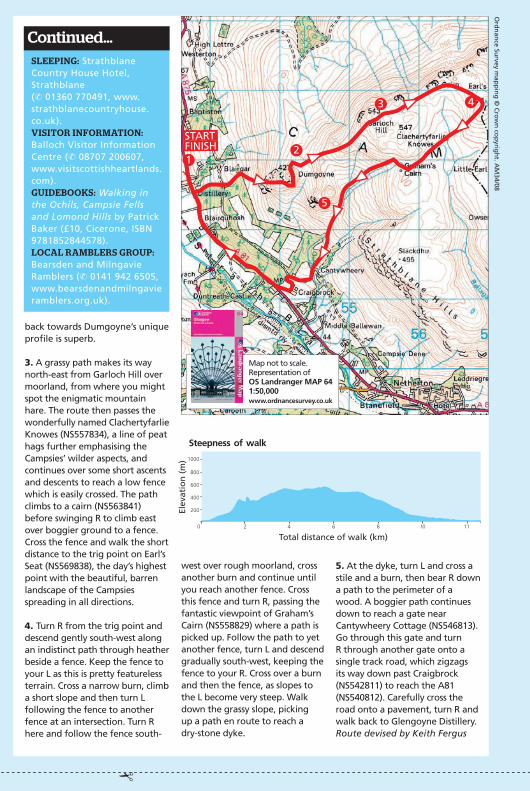
1. START Facing Glengoyne Distillery (NS527826), turn R then
bear L onto a grassy bank to reach a stile. Cross the stile into a field and follow a grassy path towards Dumgoyne. The path crosses a farm track and continues to another stile. Cross it, then a burn and another stile to reach Dumgoyne’s lower slopes. A good path ascends east up very steep slopes, although near the top the path bears R and – with the gradient easing – a simple walk leads to Dumgoyne’s summit (NS542828). The panoramic views are astounding across Glasgow and beyond – the Southern Highlands with Ben Lomond and Ben Ledi are clearly visible.
2. very carefully, descend north-east from Dumgoyne down a steep path until you reach a flatter plateau. The path then rises north-east over open moor-land, passing the remains of a cottage to reach Garloch Hill (NS553837). The wilder side of The Campsies become more apparent here, whilst the view
Where: Circular walk in peaceful, untamed countryside around Glengoyne Distillery, near Glasgow.Start/end: Beside Glengoyne Distillery (NS526827).terrain: Hill paths, moorland, single track road and a short section of pavement. One steep ascent and descent, and some stiles and low fences to negotiate.MapS: OS Explorer 348; Landranger 64.GettinG there: Regular buses from Glasgow to Glengoyne (✆ 0871 200 2233, www.travelinescotland.com).eatinG & drinkinG: The Blane valley Inn, Blanefield (✆ 01360 770303); the distillery at the start/end point offers whisky tours and tasting sessions: Glengoyne Distillery, Dumgoyne (✆ 01360 550 254, www.glengoyne.com). ▲
▼
Pho
tog
raPh
y: a
lam
y
l
Stornoway
CARLABHAGH
l
Dhail Beag
Isle of Harris
ISLE OF LEWIS
plan your walk
l
Glasgow
THE CAMPSIE FELLS
STIRLINGSHIRE
l
Clydebank
l
Lennoxtown
l
Bishopbriggs
l
Duntreath Castle
l
Paisley
(✆ 08457 225225; www.eastcoast.co.uk).Eating & drinking: Callanish visitor centre, Callanish (✆ 01851 621422, www.callanishvisitorcentre.co.uk) – a café and shop run by a local community trust.SlEEping: Callanish Farmhouse (see contact details for the visitor centre above) – a converted two-bedroom farmhouse managed by the community trust and located by the Callanish stone circle. There’s also a converted blackhouse at Gearrannan (✆ 01851 643416; www.gearrannan.com). ViSitor information: Stornoway Tourist Information Centre, 26 Cromwell Street, Stornoway, Isle of Lewis (✆ 01851 703088; www.visithebrides.com).guidEbookS: Walking on Harris and Lewis by Richard Barrett (£12.95, Cicerone, ISBN 978 1852845674); Suas Gu Deas by Angus Peter Campbell and Cailean Maclean (£20, Islands Book trust, ISBN 978 0956076434).local ramblErS group: Highland Ramblers, Inverness (✆ 07821 936297, www.highlandramblers.org.uk/inverness).
continued...
encircling Loch Roag. Out to sea you’ll spot the Flannan Islands, scene of the unresolved disappearance of three lighthouse keepers in 1900. After a violent December storm, coastguards arrived to find the table set for dinner, but no trace of the keepers.
3. From Aird Mhor the path drops to Fivig Burn and then climbs to the next headland,
Aird Mheadhonach (NB199455). You’ll often come across exposed boulders of Lewisian gneiss – at three billion years old they’re some of the earliest known rocks on the planet. A developing sea stack, known as Stac a Chaisteil, remains tethered – just – to the cliffs here, and you’ll see kittiwakes and fulmars. With binoculars you should pick out a cairn and remains of an Iron Age fort on the stack.
4. Just beyond the sea stack is Aird Ghobhann (NB205456), the last major headland on this route. From here, a grassy bluff zig-zags through turf terraces down to a fence (NB208451). Cross it and then follow more waymarkers beneath the hill of Beinn Bheag to the beautiful
Ord
nan
ce Survey m
app
ing
© C
row
n co
pyrig
ht. A
M34/08
beach of Dail Mor (NB215452). At the top of the bay is a lonely sand-blown cemetery.
5. From Dail Mor the path heads north-east between a fence and a stone wall, beneath the hill of Creag an Taghain, and across a fence by a stile (NB219452). You then keep ahead beneath the hill of Cleit Dalbeg, cross a small stream and then turn R, with a fence on your L. After 150m, turn L over the fence to reach a minor road. Turn L again to reach Dhail Beag (NB227459) – a true gem of a beach. On the way you’ll pass Loch Dhailbeag, fringed with seaweed. Sand blown from the beaches adds a shimmer to its peaty depths. In summer, waterlilies cover the surface.Route devised by Mark Rowe
SlEEping: Strathblane Country House Hotel, Strathblane (✆ 01360 770491, www.strathblanecountryhouse.co.uk).ViSitor information: Balloch Visitor Information Centre (✆ 08707 200607, www.visitscottishheartlands.com).guidEbookS: Walking in the Ochils, Campsie Fells and Lomond Hills by Patrick Baker (£10, Cicerone, ISBN 9781852844578). local ramblErS group: Bearsden and Milngavie Ramblers (✆ 0141 942 6505, www.bearsdenandmilngavie ramblers.org.uk).
continued…
back towards Dumgoyne’s unique profile is superb.
3. A grassy path makes its way north-east from Garloch Hill over moorland, from where you might spot the enigmatic mountain hare. The route then passes the wonderfully named Clachertyfarlie Knowes (NS557834), a line of peat hags further emphasising the Campsies’ wilder aspects, and continues over some short ascents and descents to reach a low fence which is easily crossed. The path climbs to a cairn (NS563841) before swinging R to climb east over boggier ground to a fence. Cross the fence and walk the short distance to the trig point on Earl’s Seat (NS569838), the day’s highest point with the beautiful, barren landscape of the Campsies spreading in all directions.
4. Turn R from the trig point and descend gently south-west along an indistinct path through heather beside a fence. Keep the fence to your L as this is pretty featureless terrain. Cross a narrow burn, climb a short slope and then turn L following the fence to another fence at an intersection. Turn R here and follow the fence south-
Ord
nan
ce Survey m
app
ing
© C
row
n co
pyrig
ht. A
M34/08
Map not to scale. Representation of OS Landranger MAP 64 1:50,000www.ordnancesurvey.co.uk
Map not to scale. Representation of OS Explorer MAP 460 1:25,000www.ordnancesurvey.co.uk
2
1START
3
4
5
FINISH
west over rough moorland, cross another burn and continue until you reach another fence. Cross this fence and turn R, passing the fantastic viewpoint of Graham’s Cairn (NS558829) where a path is picked up. Follow the path to yet another fence, turn L and descend gradually south-west, keeping the fence to your R. Cross over a burn and then the fence, as slopes to the L become very steep. Walk down the grassy slope, picking up a path en route to reach a dry-stone dyke.
START FINISH 2
3
1
4
5
Total distance of walk (km)
1000
800
600
400
200
0 2 4 6 8 10 11
Steepness of walk
Elev
atio
n (
m)
5. At the dyke, turn L and cross a stile and a burn, then bear R down a path to the perimeter of a wood. A boggier path continues down to reach a gate near Cantywheery Cottage (NS546813). Go through this gate and turn R through another gate onto a single track road, which zigzags its way down past Craigbrock (NS542811) to reach the A81 (NS540812). Carefully cross the road onto a pavement, turn R and walk back to Glengoyne Distillery.Route devised by Keith Fergus
Total distance of walk (km)0 1 2 3 4 5 6 7 8 9
Steepness of walk
Elev
atio
n (
m)
200
150
100
50