macquarie-castlereagh long term water plan part a
TRANSCRIPT

DEPARTMENT OF PLANNING, INDUSTRY & ENVIRONMENT
Macquarie–Castlereagh Long Term Water Plan
Part A: Macquarie–Castlereagh catchment
environment.nsw.gov.au

© 2020 State of NSW and Department of Planning, Industry and Environment
With the exception of photographs, the State of NSW and Department of Planning, Industry and Environment are pleased to allow this material to be reproduced in whole or in part for educational and non-commercial use, provided the meaning is unchanged and its source, publisher and authorship are acknowledged. Specific permission is required for the reproduction of photographs.
The Department of Planning, Industry and Environment (DPIE) has compiled this report in good faith, exercising all due care and attention. No representation is made about the accuracy, completeness or suitability of the information in this publication for any particular purpose. DPIE shall not be liable for any damage which may occur to any person or organisation taking action or not on the basis of this publication. Readers should seek appropriate advice when applying the information to their specific needs.
All content in this publication is owned by DPIE and is protected by Crown Copyright, unless credited otherwise. It is licensed under the Creative Commons Attribution 4.0 International (CC BY 4.0), subject to the exemptions contained in the licence. The legal code for the licence is available at Creative Commons.
DPIE asserts the right to be attributed as author of the original material in the following manner: © State of New South Wales and Department of Planning, Industry and Environment 2020.
Cover photo: Macquarie Marshes, John Spencer/DPIE
Published by:
Environment, Energy and Science Department of Planning, Industry and Environment 4 Parramatta Square, 12 Darcy Street, Parramatta NSW 2150 Phone: +61 2 9995 5000 (switchboard) Phone: 1300 361 967 (Environment, Energy and Science enquiries) TTY users: phone 133 677, then ask for 1300 361 967 Speak and listen users: phone 1300 555 727, then ask for 1300 361 967 Email: [email protected] Website: www.environment.nsw.gov.au
Report pollution and environmental incidents Environment Line: 131 555 (NSW only) or [email protected] See also www.environment.nsw.gov.au
ISBN 978-1-925974-97-3 EES 2020/0086 July 2020
Find out more about your environment at:
www.environment.nsw.gov.au

iii
Contents
Acknowledgement of Traditional Owners vii
Abbreviations viii
Glossary ix
Summary xiv
1. Introduction 1
1.1 Approach to developing the LTWP 1
1.2 Implementing the Macquarie-Castlereagh LTWP 2
1.3 LTWP document structure 2
1.4 Planning units 3
2. Environmental assets 5
2.1 Audit of water-dependent (priority) environmental assets 5
3. Ecological objectives and targets 7
3.1 Native fish objectives 7
3.2 Native vegetation objectives 10
River red gum forest and woodlands 11
Coolibah and black box woodlands 11
Lignum shrublands 11
Non-woody wetland vegetation 11
Objectives 11
3.3 Waterbird objectives 13
Objectives 14
3.4 Priority ecosystem function objectives 16
Drought refuge for water-dependent species 16
Quality instream habitat 16
Movement and dispersal opportunities for aquatic biota 16
Instream and floodplain productivity 16
Groundwater-dependent biota 16
Sediment, carbon and nutrient exchange 17
Inter-catchment flow contributions 17
3.5 Objectives for other species (flow-dependent frogs) 21
4. Environmental water requirements 23
4.1 Developing environmental water requirements 23
4.2 Flow threshold estimates for flow categories in the regulated Macquarie-Castlereagh 28
4.3 Catchment-scale EWRs for Macquarie-Castlereagh 32
4.4 Important flow regime characteristics needed to deliver LTWP objectives 40

iv
4.5 Changes to the flow regime 48
Areas that are regulated or affected by regulated water 48
Unregulated areas 54
5. Risks, constraints and strategies 55
5.1 Risks and constraints to meeting EWRs in the Macquarie-Castlereagh WRPA 56
5.2 Non-flow related risks and constraints to meeting LTWP objectives 59
5.3 Dealing with the risk of climate change 65
Identifying climate-related risks to water management 65
6. Water management under different water availability scenarios 67
6.1 Prioritisation of ecological objectives and watering in regulated river reaches 67
6.1.1 Water RAS: Very dry - Protect 68
6.1.2 Water RAS: Dry - Maintain 69
6.1.3 Water RAS: Moderate – Maintain and Recover 70
6.1.4 Water RAS: Wet – Maintain and Improve 72
6.2 Water management during ecologically critical water quality incidents and extreme conditions 74
6.3 Protection of ecologically important flow categories in unregulated river reaches 76
7. Going forward 78
7.1 Potential further actions for water management. 78
7.2 Cooperative water use 78
7.3 Complementary actions 79
7.4 Measuring progress 84
7.5 Review and update 85
References 86
Appendix A: LTWP objectives relevant to each planning unit in the Macquarie-Castlereagh WRPA 90
Appendix B: RAS guidelines 92
List of tables
Table 1 Native fish ecological objectives 8
Table 2 Native vegetation ecological objectives 12
Table 3 Waterbird ecological objectives 15
Table 4 Ecosystem function objectives 18
Table 5 Objectives for other species (flow-dependent frogs) 22
Table 6 Description of function role provided by flow categories 24

v
Table 8 Flow threshold estimates for flow categories in the regulated Macquarie-Castlereagh WRPA 28
Table 9 Catchment-scale EWRs for Macquarie-Castlereagh WRPA 32
Table 10 Important flow regime characteristics needed to deliver LTWP objectives 40
Table 11 Predicted inundated areas for specific flow scenarios 50
Table 12 Water management related risks and constraints to meeting objectives and potential strategies for managing them 56
Table 13 Non-flow management related risks and constraints to meeting LTWP ecological objectives 60
Table 14 Projected change in rainfall patterns and weather in the Central West and Orana district from 2020 to 2079 due to climate change NARCLiM (nd) 65
Table 15 Priority LTWP objectives and flow categories in a very dry RAS 68
Table 16 Priority LTWP objectives and flow categories in a dry RAS 69
Table 17 Priority objectives and flow categories in a moderate RAS 70
Table 18 Priority LTWP objectives and flow categories in a wet RAS 72
Table 19 Priorities and strategies for managing water during critical water quality incidents 74
Table 20 Priorities and strategies for managing water during extreme conditions 75
Table 21 Potential management strategies for meeting LTWP objectives in unregulated river reaches of the Macquarie Castlereagh WRPA 76
Table 22 Recommended further investment and projects to improve environmental water outcomes in the Macquarie-Castlereagh WRPA 80
Table 23 Default matrix for determining the RAS (MDBA 2012b) 92
List of figures
Figure 1 Aerial view of the Macquarie Marshes vii
Figure 2 The Macquarie-Castlereagh WRPA showing the division of planning units 4
Figure 3 The five criteria for the identification of environmental assets and locations that fulfil these criteria 5
Figure 4 Murray cod 10
Figure 5 Intermediate egret in breeding plumage 14
Figure 6 Salmon striped frog 21
Figure 7 A simplified conceptual model of the role of flow regime components 24

vi
Figure 8 Schematic of the main watercourses and streamflow gauges used for EWRs (not to scale) 31
Figure 9 Burrendong Dam offtake tower with cold water curtain 48
Figure 10 Areas of the inundation in the Macquarie Marshes based on flow scenarios of different sizes listed in Table 11 from Thomas et al. (in prep) 51
Figure 11 Occurrence of events in Macquarie Marshes, based on flow scenarios of different sizes listed in Table 10 from Thomas et al. (in prep). 52
Figure 12 Sunset over Macquarie Marshes 55
Figure 13 Golden perch 64
Figure 14 Burrendong Dam offtake tower with cold water curtain 79

Macquarie-Castlereagh Long Term Water Plan Part A
vii
Acknowledgement of Traditional Owners
The NSW Department of Planning, Industry and Environment pays its respect to the Traditional Owners and their Nations of the Murray-Darling Basin. The contributions of earlier generations, including the Elders, who have fought for their rights in natural resource management are valued and respected.
In the Macquarie-Castlereagh Water Resource Plan Area, the NSW Department of Planning, Industry and Environment pays its respects to the Traditional Owners – the Gomeroi/Kamilaroi, Ngemba, Ngiyampaa, Wailwan, Wiradjuri Nations – past, present and future. We look forward to building upon existing relationships to improve the health of our rivers, wetlands and floodplains including recognition of their traditional and ongoing cultural and spiritual significance.
Figure 1 Aerial view of the Macquarie Marshes Photo John Spencer/DPIE
Macquarie-Castlereagh Long Term Water Plan Part A
viii
Abbreviations
Basin Plan Murray-Darling Basin Plan
BWS Basin-wide environmental watering strategy
CAG Customer Advisory Group
CAMBA China-Australia Migratory Bird Agreement
CEWH Commonwealth Environmental Water Holder
CEWO Commonwealth Environmental Water Office
DO Dissolved oxygen
DOC Dissolved organic carbon
DPIE NSW Department of Planning, Industry and Environment
DPIE-BC NSW Department of Planning, Industry and Environment – Biodiversity and Conservation Division
DPIE-Water NSW Department of Planning, Industry and Environment –Water
DPI-Fisheries NSW Department of Primary Industries Fisheries
EWA Environmental water allowance
EFRG Environmental Flows Reference Group (the Macquarie Cudgegong EWAG)
EWAG Environmental Water Advisory Group
EWR Environmental water requirement
HEW Held environmental water
JAMBA Japan-Australia Migratory Bird Agreement
LLS NSW Local Land Services
LTWP Long Term Water Plan
MDBA Murray-Darling Basin Authority
MER Monitoring, evaluation and reporting
mg/L milligrams per litre
ML megalitre
ML/d megalitres per day
m/s metres per second
NPWS NSW National Parks and Wildlife Services
NRAR NSW Natural Resources Access Regulator
NSW New South Wales
DPIE NSW Department of Planning, Industry and Environment
DPIE-BC NSW Department of Planning, Industry and Environment – Biodiversity and Conservation Division
DPIE-Water NSW Department of Planning, Industry and Environment – Water Division
PEW Planned environmental water
ROKAMBA Republic of Korea-Australia Migratory Bird Agreement
SDL Sustainable diversion limit
WRP Water resource plan
WRPA Water resource plan area
WSP Water sharing plan

Macquarie-Castlereagh Long Term Water Plan Part A
ix
Glossary
Actively managed floodplain
The floodplains and wetlands that can be inundated by flows from regulated rivers (see ‘Regulated river’).
Adaptive management
A procedure for implementing management while learning about which management actions are most effective at achieving specified objectives.
Allocation The volume of water made available to a water access licence or environmental water allowances in a given period by DPIE-Water, which is typically determined within the context of demand, inflows, and stored water.
Alluvial Comprised of material deposited by water.
Bankfull flow River flows at maximum channel capacity with little overflow to adjacent floodplains. Engages the riparian zone, anabranches and flood runners and wetlands located within the meander train. Inundates all in channel habitats including all benches, snags and backwaters.
Baseflow Reliable background flow levels within a river channel that are generally maintained by seepage from groundwater storage, but also by surface inflows. Typically inundates pools and riffle areas.
Basin Plan The Basin Plan as developed by the Murray-Darling Basin Authority under the Water Act 2007.
Biota The organisms that occupy a geographic region.
Blackwater Occurs when water moves across the floodplain and releases organic carbon from the soil and leaf litter. The water takes on a tea colour as tannins and other carbon compounds are released from the decaying leaf litter. The movement of blackwater plays an important role in transferring essential nutrients from wetlands into rivers and vice versa. Blackwater carries organic carbon compounds which are the basic building block of the aquatic food web and an essential part of a healthy river system. See ‘hypoxic blackwater’ below for those occasions this can cause significant water quality issues.
Carryover Water allocated to water licences or environmental water accounts that remains un-used at the end of the water year which, under specific circumstances, may be held over and used in the following water year/s.
Cease-to-flow The absence of flowing water in a river channel. Partial or total drying of the river channel. Streams contract to a series of isolated pools.
Cease-to-pump (access rule in WSP)
This is a low flow restriction on access to water for Works Approval Licences. Generally, licenced take is not permitted:
1. from in-channel pools and from natural off-river pools when the water level is lower than its full capacity
2. from pump sites when there is no visible flow
These rules typically apply unless there is a commence-to-pump access rule that specifies a higher flow rate that licence holders can begin pumping.
Constraints The physical or operational constraints that effect the ability to meet flow levels in the river or wetlands. These include limitations on the delivery of water from storages to extraction or diversion points or to wetland areas. Constraints may include structures such as bridges that can be affected by higher flows, or the volume of water that can be carried through the river channel, or scheduling of downstream water deliveries from storage.
Consumptive water Water that is removed from surface and groundwater systems without return to a water resource system (such as water removed from a river for agriculture, mining or urban use).

Macquarie-Castlereagh Long Term Water Plan Part A
x
Cultural water-dependent asset
A place that has social, spiritual and cultural value based on its cultural significance to Aboriginal people and is reliant upon surface or groundwater supply for its values.
Cultural water-dependent value
An object, plant, animal, spiritual connection or use that is dependent on water and has value based on its cultural significance to Aboriginal people.
Discharge The amount of water moving through a river system, most commonly expressed in megalitres per day (ML/d).
Dissolved Organic Carbon (DOC)
A measurement of the amount of carbon from organic matter that is soluble in water. DOC is transported by water from floodplains to river systems and is a basic building block available to bacteria and algae that are food for microscopic animals that are in turn consumed by fish larvae, small bodied fish species, yabbies and shrimp. DOC is essential for building the primary food webs in rivers and ultimately generates a food source for large-bodied fish like Murray cod and golden perch and predators such as waterbirds.
Ecological function The resources and services that sustain human, plant and animal communities and are provided by the processes and interactions occurring within and between ecosystems.
Ecological objective
The defined goal for a state, condition or characteristic of an ecological asset or function.
Ecological target Level of measured performance that must be met to achieve the defined objective. The targets in this long term water plan are SMART (Specific/Measurable/Achievable/ Realistic/Time-bound).
Ecological value An object, plant or animal which has value based on ecological significance.
Ecosystem A biological community of interacting organisms and their physical environment. It includes all the living things in that community, interacting with their non-living environment (weather, earth, sun, soil, climate and atmosphere) and with each other.
Environmental asset
An object, area, species or ecological community that has ecological value, e.g. wetlands, species, riverine forests.
Environmental Water Allowance (EWA)
An allowance of water provided by the Water Sharing Plan Water Sharing Plan for the Macquarie and Cudgegong Regulated Rivers Water Source for environmental purposes.
Environmental water
Water for meeting the requirements of water-dependent ecosystems. It provides a multitude of benefits to not only the environment, but to communities, industry and society. It includes held environmental water and planned environmental water.
Environmental water requirement (EWR)
The water required to support the completion of all elements of a lifecycle of an organism or group of organisms (taxonomic or spatial), consistent with the objective/target, measured at the most appropriate gauge. Includes all water in the system including natural inflows, held environmental water and planned environmental water.
Five-year rolling period
Period of time used for monitoring and evaluation. This looks at every 5-year period on a continuous basis.
Flow category The type of flow in a waterway defined by its magnitude, season, shape and role (e.g. bankfull, spring fresh for native fish breeding).
Flow-dependent In the context of this plan, an ecosystem, community or species that depends on periodic or sustained inundation, waterlogging or significant inputs of surface water for part or all of its lifecycle. See also ‘water-dependent.’
Flow-dependent frog
Frog species that respond with breeding behaviour to wetland filling from surface water flows. Other species respond primarily to local rainfall events but may also utilise wetlands if rainfall coincides with filling.
Flow regime The pattern of flows in a waterway or wetland over time that will influence the response and persistence of plants, animals and their ecosystems.

Macquarie-Castlereagh Long Term Water Plan Part A
xi
Freshes Temporary in-channel flow pulse that typically happens in response to rainfall or release from water storages. Very important for a range of ecological values.
General security A category of water entitlement where water is made available to licence holder accounts based upon dam inflows. This forms the majority, by volume, of water entitlements in the regulated sections of the river including irrigation. The Commonwealth and NSW governments hold general security access licences to use for the environment.
Groundwater Water that is located below the earth’s surface in soil pore spaces and in the fractures of rock formations. Groundwater is recharged from, and can eventually flow to, the surface naturally.
Held environmental water
Water available under a water access right, a water delivery right, or an irrigation right for the purposes of achieving environmental outcomes (including water that is specified in a water access right to be for environmental use).
Hydrological connectivity
The link of natural aquatic environments.
Hydrology The occurrence, distribution and movement of water.
Hypoxic blackwater Occurs when dissolved oxygen (DO) levels fall below the level needed to sustain native fish and other water dependent species. Bacteria feed on dissolved organic carbon use oxygen in the water. When they multiply rapidly their rate of oxygen consumption can exceed the rate at which oxygen can be dissolved in the water and oxygen levels fall and a hypoxic (low oxygen) condition occurs. This is typically not a frequent problem in the Macquarie-Castlereagh WRPA.
Dissolved oxygen is measured in milligrams per litre (mg/litre). Generally native fish begin to stress when DO levels fall below 4 mg/litre. Fish mortality occurs when DO levels are less than 2 mg/litre.
Key environmental asset
An asset that is identified for its special conservation significance based on selected temporal and spatial criteria.
Key ecological value
A species or community that is identified for its special conservation significance based on selected temporal and spatial criteria. Examples include Murray cod or river red gum woodlands.
Large fresh A high-magnitude flow pulse that remains in-channel. May engage flood runners with the main channel and inundate low-lying wetlands. Connects most in channel habitats and provides partial longitudinal connectivity, as some low-level weirs and other in channel barriers may be drowned out. Highly important for aquatic ecosystems.
Lateral connectivity The flow linking rivers channels and the floodplain
Long Term Water Plan (LTWP)
Plans required of Basin States by the Murray-Darling Basin Plan. Long term water plans give effect to the Basin-wide Environmental Watering Strategy relevant for each river system and will guide the management of water over the longer term. These plans will identify the environmental assets that are dependent on water for their persistence, and match that need to the water available to be managed for or delivered to them. The plan will set objectives, targets and watering requirements for key plants, waterbirds, fish and ecosystem functions. DPIE is responsible for the development of nine plans for river catchments across NSW, with objectives for five, 10 and 20-year timeframes.
Longitudinal connectivity
The flow link along the length of a river.
Overbank flow Flows that spill over the riverbank or extend to floodplain surface flows.
Planned environmental water
Water that is committed by the Basin Plan, a water resource plan or a plan made under state water management law to specifically achieve environmental outcomes.

Macquarie-Castlereagh Long Term Water Plan Part A
xii
Planning Unit (PU) A geographical division of a water resource plan area based on water requirements (in catchment areas in which water is actively managed), or a sub-catchment boundary (all other areas).
Population structure (ecological)
A healthy population structure has individuals in a range of age and size classes. These populations demonstrate regular recruitment, good numbers of sexually mature individuals and genetic variation.
Priority ecological function
In the context of this plan, is a water-dependent ecological function that can be influenced by environmental water.
Priority environmental asset
In the context of this plan, is a place of particular ecological significance that contains values and functions that are water-dependent and can be influenced by environmental water.
Ramsar Convention
The Convention on wetlands, called the Ramsar Convention, is an intergovernmental treaty that provides the framework for national action and international cooperation for the conservation and wise use of wetlands and their resources.
Recruitment (ecological)
Successful development and growth of offspring within a population; such that they can contribute to the next generation.
Refuge (ecological) An area which provides conditions to assist individuals within a population of plants or animals to survive through a period of decreased water availability.
Registered cultural asset
A cultural water-dependent asset that is registered in the NSW Aboriginal Heritage Information Management System.
Regulated river A river that is gazetted under the NSW Water Management Act 2000. Flow is largely controlled by major dams, water storages and weirs. River regulation brings more reliability to water supplies but has interrupted the natural flow characteristics and regimes required by native fish and other plant and animal to breed, feed and grow.
Riffle A rocky or shallow part of a river where river flow is rapid and broken.
Riparian The part of the landscape adjoining rivers and streams that has a direct influence on the water and aquatic ecosystems within them.
Small fresh Low-magnitude in-channel flow pulse. Unlikely to drown out any significant barriers, but can provide limited connectivity and a biological trigger for animal movement.
Supplementary access licence
A category of water entitlement where water is made available to licence holders during periods of high river flows, subject to triggers. Water can be taken and debited from licence accounts during a declared period. The Commonwealth and NSW governments hold supplementary access licences to use for the environmental.
Surface water Water that exists above the ground in rivers, streams creeks, lakes and reservoirs. Although separate from groundwater, they are interrelated and over extraction of either will impact on the other.
Sustainable diversion limit (SDL)
The total amount of water that can be extracted from Murray-Darling Basin rivers for human uses. Water in the system above the SDL is protected to achieve environmental outcomes.
Thermal (including coldwater) pollution
The artificial lowering or raising of water temperature that occurs downstream of large dams, particularly during warmer months when they stratify.
Unregulated river A waterway where flow is mostly uncontrolled by dams, weirs or other structures.
Very low flow Minimum flow in a channel that prevents a cease-to-flow. Provides limited connectivity between pools and maintains water level in refuge pools.
Water quality management plan (WQSMP)
A document prepared by state authorities and accredited by the Commonwealth under the Basin Plan. Makes up part of the Water Resource Plan. It aims to provide a framework to protect, enhance and restore water quality in each water resource plan area.

Macquarie-Castlereagh Long Term Water Plan Part A
xiii
Water resource plan (WRP)
A document prepared by state authorities and accredited by the Commonwealth under the Basin Plan. The document describes how water will be managed and shared between users in an area.
Water resource plan area (WRPA)
Catchment-based divisions of the Murray-Darling Basin defined by a water resource plan.
Water sharing plan (WSP)
A plan made under the NSW Water Management Act 2000 that sets out specific rules for sharing and trading water between the various water users and the environment in a specified water management area. A water sharing plan will be a component of a water resource plan.
Water-dependent A term used in the Basin Plan. In the context of this plan, an ecosystem, community or species that depends on periodic or sustained inundation, waterlogging or significant inputs of surface water for part or all of its lifecycle.

Macquarie-Castlereagh Long Term Water Plan Part A
xiv
Summary
Rivers, creeks, wetlands and floodplains play a vital role in sustaining healthy communities and economies. They provide productivity and connections across the landscape for people, plants and animals with benefits that extend well beyond the river bank.
Over the past 200 years, many rivers, wetlands and floodplains in New South Wales (NSW) have had their natural flow regimes disrupted because of dams, weirs, floodplain development, and water regulation and extraction.
The Macquarie-Castlereagh Long Term Water Plan (LTWP) is an important step to describing the flow regimes that are required to maintain or improve environmental outcomes in the Macquarie-Castlereagh catchment. The plan identifies water management strategies for maintaining and improving the long-term health of the Macquarie-Castlereagh’s riverine and floodplain environmental assets and the ecological functions they perform. This includes detailed descriptions of ecologically important river flows and risks to achieving ecological objectives.
Importantly, the LTWP does not prescribe how environmental water should be managed in the future, rather it will help water managers and advisory groups, such as the Macquarie-Castlereagh Environmental Flows Reference Group, make decisions about where, when and how water can be used to achieve agreed long-term ecological objectives.
The LTWP looks at all sources of water and how these can be managed to help support environmental outcomes in the catchment.
Background to Long Term Water Plans
The Basin Plan (Pt 4, Ch. 8) establishes a framework for managing environmental water at the Basin and catchment-scale. The framework is designed to ensure environmental water managers work collaboratively to prioritise water use to meet the long-term needs of native fish, water-dependent native vegetation and waterbirds and co-ordinate water use across multiple catchments to achieve Basin-scale outcomes.
The Basin-wide Environmental Watering Strategy (BWS) and LTWPs are central features of this framework. The BWS establishes long-term environmental outcomes and targets for the Basin and its catchments. LTWPs, which apply to water resource plan areas (WRPAs) (catchment-scale), must contribute to the achievement of the BWS by identifying:
• priority environmental assets and functions in a WRPA
• ecological objectives and ecological targets for those assets and functions
• environmental watering requirements (EWRs) needed to meet those targets and achieve the objectives.
Water resource plans (WRPs) must have regard to LTWPs.
The Macquarie-Castlereagh Long Term Water Plan
The Macquarie-Castlereagh LTWP is one of nine plans being developed by the NSW Department of Planning, Industry and Environment (DPIE) to cover the NSW portion of the Murray-Darling Basin. Development of the LTWP has involved six main steps:
• undertaking a comprehensive stocktake of water-dependent environmental assets and ecosystem functions across the catchment to identify native fish, water-dependent bird and vegetation species, and river processes that underpin a healthy river system.
• determining specific and quantifiable objectives and targets for the key species and functions in the Macquarie-Castlereagh WRPA.
• determining the environmental water requirements (EWRs) (including volume, frequency, timing and duration) needed to achieve the objectives and targets.

Macquarie-Castlereagh Long Term Water Plan Part A
xv
• identifying the risks and constraints to meeting the long-term water requirements of priority environmental assets and ecosystem functions.
• identifying potential management strategies for guiding water management decisions and investment into the future.
• identifying complementary investments to address risks and constraints to meeting the long-term water requirements of priority environmental assets and ecosystem functions.
The LTWP presents this information in nine chapters in two parts, with accompanying appendices.
Environmental values of the Macquarie-Castlereagh catchment
The Macquarie-Castlereagh catchment supports a range of water-dependent ecosystems, including instream aquatic habitats, riparian forests, and floodplain watercourses, woodlands and wetlands. Notably, the Macquarie Marshes are on the List of Wetlands of International Importance (the Ramsar List), and the Directory of Important Wetlands in Australia. These ecosystems benefit many water-dependent species and communities, including threatened ecological communities, threatened and migratory waterbirds, and threatened native fish species, by providing habitat and food resources.
The ecological condition of the Macquarie-Castlereagh’s water-dependent environmental assets is largely driven by flows that connect the instream benches, anabranches, floodplains and wetlands. Flows that provide these connections support organic carbon transfer and nutrient cycling, trigger movement and breeding of native fish and waterbirds, and directly impact vegetation condition and habitat availability.
Extensive local and scientific knowledge about the Macquarie-Castlereagh’s riverine environmental assets and ecosystem functions underpins this LTWP. This has been collected in partnership with water managers, natural resource managers, environmental water holders, landholders, and community members. Information about the Macquarie-Castlereagh’s environmental values closely aligns with material in the NSW Department of Planning, Industry and Environment Macquarie-Castlereagh’s Water Resource Plan Risk Assessment (DPIE-Water, in prep.).
Water for the environment
The Macquarie-Castlereagh LTWP contains ecological objectives and targets for priority environmental assets and ecosystem functions in the Macquarie-Castlereagh catchment. Priorities are defined by the Basin Plan as those assets and functions that can be managed with environmental water. Objectives and targets have been identified in this LTWP for native fish, native vegetation, waterbirds, river connectivity and flow-dependent frogs.
The objectives of this plan reflect the current understanding of outcomes that might be expected from implementation of the Basin Plan in the rivers, wetlands, floodplains, and watercourses of the Macquarie-Castlereagh catchment. The targets for each ecological objective provide a transparent means of evaluating progress towards their achievement and the long-term success of management strategies.

Macquarie-Castlereagh Long Term Water Plan Part A: Macquarie-Castlereagh catchment
1
1. Introduction
A major catchment in the Murray-Darling Basin, the Macquarie-Castlereagh WRPA is located in central-western NSW. It extends west from the Blue Mountains in the Great Dividing Range to the confluence of the Barwon River east of Brewarrina. Major towns and cities supported by the Macquarie River include Bathurst, Wellington, Dubbo and Warren. Other major rivers in the system include the Castlereagh and Bogan.
Home to the Macquarie Marshes, this catchment supports one of the largest remaining semi-permanent wetland systems in inland Australia. Listed under the Ramsar Convention, the Macquarie Marshes support a variety of important flow-dependent vegetation communities and is one of the largest colonial waterbird breeding sites in Australia.
The waterways and aquifers of the Macquarie-Castlereagh are important water resources for agricultural businesses and urban communities, with the Macquarie Marshes supporting a highly productive grazing industry.
The region supports a diverse range of flow-dependent threatened and iconic species including:
• native fish (e.g. trout cod, Murray cod, silver perch, southern purple-spotted gudgeon and eel-tailed catfish)
• vegetation communities (e.g. coolibah, black box, river red gum, lignum, reedbeds)
• waterbirds (e.g. straw-necked ibis, intermediate egret, great egret, Australian painted snipe, magpie goose, glossy ibis).
River flows in the Macquarie-Castlereagh WRPA have been altered by two major headwater storages—Burrendong and Windamere dams—as well as weirs and floodplain development to support primary production. Flow volumes, as well as the regularity of small to moderate-sized flow events, have reduced compared to natural conditions as a result. These change the ability of the river system to support the catchment’s riverine and floodplain ecosystems.
The NSW Government has developed this plan with the aim of protecting and improving the health of the Macquarie-Castlereagh’s riverine and floodplain ecosystems. The plan provides information on the catchment’s long-term environmental water requirements (EWRs). It also recognises the Macquarie-Castlereagh’s connection and role within the Murray-Darling Basin in supporting the environmental health of downstream catchments, particularly the Barwon-Darling River.
1.1 Approach to developing the LTWP
The Macquarie-Castlereagh LTWP (‘the plan’) applies to the Macquarie-Castlereagh WRPA and is one of nine catchment-based plans covering the NSW portion of the Murray-Darling Basin. This plan is consistent with the requirements of the Basin Plan (MDBA 2012a).
This plan is the product of best available information and engagement with water managers, natural resource managers, environmental water holders and community members. It draws together local, traditional and scientific knowledge to identify the catchment’s priority environmental assets and ecosystem functions to guide the management of water to protect and restore condition over the long-term.
Development of the Macquarie-Castlereagh plan has involved six main steps.
1. System Audit: undertaking a comprehensive stocktake of water-dependent environmental assets and ecosystem functions across the Macquarie-Castlereagh WRPA to identify native fish, water-dependent bird and vegetation species, and river processes that underpin a healthy river system.
2. Objectives and targets: determining specific and quantifiable objectives and targets for the key species and functions in the Macquarie-Castlereagh WRPA.

Macquarie-Castlereagh Long Term Water Plan Part A: Macquarie-Castlereagh catchment
2
3. EWRs: using available science and management experience to determine the water requirements (including volume, frequency, timing and duration) needed to sustain and improve the health and/or extent of priority environmental assets and ecosystem functions.
4. Risk Assessment: identifying the risks and constraints to meeting the long-term water requirements of priority environmental assets and ecosystem functions.
5. Management Strategies: identifying potential management strategies for guiding water management decisions and investment into the future.
6. Complementary measures: identifying actions other than water management to address risks and constraints to meeting the plan’s objectives.
1.2 Implementing the Macquarie-Castlereagh LTWP
Implementation of this plan requires strong partnerships and coordination between land and water managers. This plan provides the foundation to support future coordination efforts by:
• informing annual and longer-term water management planning by environmental water managers, including strengthening collaboration between environmental water holders
• informing water planning processes that influence river and wetland health outcomes, including water sharing plans and water resource plans
• identifying opportunities for more strategic river operations by Water NSW
• helping target investment priorities for complementary actions that will effectively contribute to progressing the outcomes sought by this plan
• informing monitoring, evaluation and reporting processes for water management
• assisting to build community understanding of river and wetland health issues and management actions.
1.3 LTWP document structure
This plan is presented in nine chapters with accompanying appendices. It is divided into Part A and Part B.
Part A: Macquarie-Castlereagh catchment scale information
• Chapter 1 explains the background and purpose of the plan.
• Chapters 2 and 3 identify the Macquarie-Castlereagh’s water-dependent environmental assets and ecosystem functions, and articulate the environmental outcomes that are expected from implementation of the plan through ecological objectives and targets.
• Chapter 4 provides the EWRs that are needed to support the achievement of ecological objectives over the next five, 10 and 20 years.
• Chapter 5 describes the long-term risks and operational constraints to achieving the EWRs and ecological objectives as well as recommending management strategies to address these risks and constraints.
• Chapter 6 identifies opportunities for the use of held and planned environmental water, and other system flows to support flow regimes to meet the EWRs of the Macquarie-Castlereagh environmental assets and values under dry, moderate and wet water resource availability scenarios.
• Chapter 7 describes potential cooperative arrangements between government agencies and private landholders and prioritised investment opportunities to achieve the environmental outcomes described.

Macquarie-Castlereagh Long Term Water Plan Part A: Macquarie-Castlereagh catchment
3
Part B – planning unit information
• Present the LTWP at the planning unit (PU) scale. This includes a summary of the environmental values the PU supports, and an evaluation of the impact of water resource development on local hydrology.
1.4 Planning units
The PUs shown in Figure 2 are referred to in most chapters. The PU boundaries typically align with water source boundaries in the Macquarie-Castlereagh Water Resource Plan (NSW Government 2018). However, some of these water sources have been amalgamated or split depending how water management for the environment can be implemented. Where there are similarities between water sources they have been amalgamated, where there are differences they have been split. It is important to note that some PUs are regulated water sources or affected by regulated water (PU 1–11). Others are unregulated and not able to be influenced by regulated water deliveries (PU 12–28).

Macquarie-Castlereagh Long Term Water Plan Part A: Macquarie-Castlereagh catchment
4
Figure 2 The Macquarie-Castlereagh WRPA showing the division of planning units

Macquarie-Castlereagh Long Term Water Plan Part A: Macquarie-Castlereagh catchment
5
2. Environmental assets
The Macquarie-Castlereagh WRPA supports a variety of water-dependent ecosystems, including instream aquatic habitats, floodplain woodlands and wetlands. These features are spread throughout the catchment and each has their own water requirements depending on the plants and animal species they support and ecosystem functions they perform.
2.1 Audit of water-dependent (priority) environmental
assets
Schedule 8 of the Basin Plan outlines criteria for identifying water-dependent ecosystems that should be recognised as environmental assets in the Murray-Darling Basin. The criteria are designed to identify water-dependent ecosystems that are internationally important, natural or near-natural, provide vital habitat for native water-dependent biota, and/or can support threatened species, threatened ecological communities or significant biodiversity.
The Macquarie-Castlereagh’s water-dependent ecosystems, which are comprised of waterbodies and surrounding water-dependent vegetation, were assessed against the Schedule 8 criteria. Significant Aboriginal cultural water-dependent sites that are registered in the Aboriginal Heritage Information Management System were also included as water-dependent assets in the LTWP. This includes areas such as recorded Aboriginal ceremony and dreaming sites, fish traps, scar trees, and water holes throughout the Macquarie-Castlereagh WRPA.
Results of the analysis are presented in Figure 3. For more information on this assessment process, refer to Long Term Water Plan Background Information (NSW DPIE 2018).
Figure 3 The five criteria for the identification of environmental assets and locations that fulfil these criteria

Macquarie-Castlereagh Long Term Water Plan Part A: Macquarie-Castlereagh catchment
6
Priority environmental assets in LTWP’s are the assets that have been identified using Schedule 8 criteria that can be managed with planned and held environmental water. These include areas:
• subject to discretionary environmental water management, such as the Macquarie Marshes and along regulated streams, including the Macquarie River
• downstream of the regulated system that are also subject to managed environmental flows, such as the Lower Macquarie River (downstream of the Marshes) and the Lower Marthaguy Creek
• supported by implementation of the water sharing plan rules, including regulated and unregulated streams and floodplains.
Priority environmental assets may be a reach of river channel and its floodplain features at a geographic location, or a wetland complex or anabranch.

Macquarie-Castlereagh Long Term Water Plan Part A: Macquarie-Castlereagh catchment
7
3. Ecological objectives and targets
Ecological objectives and targets have been established for priority environmental assets in the Macquarie-Castlereagh WRPA (sections 3.1–3.5). They are grouped into five themes—native fish, native vegetation, waterbirds, ecosystem functions and other species. The first four themes are consistent with the BWS (MDBA 2014a). Each theme is a good indicator of river system health and is responsive to flow. The water requirements of foundational species, communities or ecosystem functions within each theme are also broadly representative of those needed by many of catchment’s water-dependent species that do not fit within the five themes, such as turtles, platypus, mussels and yabbies.
The ecological objectives express the environmental outcomes that are expected from implementation of the LTWP. Their achievement will also contribute to the landscape and basin-scale environmental outcomes sought by the BWS.
The five, 10 and 20-year targets for each ecological objective provide a transparent means for evaluating progress over time and test the LTWP’s management strategies and their implementation. It is hoped that these targets, if achieved, will be a suitable indicator of overall trends in ecosystem health. It is recognised that prevailing conditions such as drought and floods will influence our ability to meet targets in 5-year increments, and these will need to be taken into account in analysis of outcomes. Failure to meet targets should trigger re-assessment of the related flow regime and whether the LTWP is being implemented as intended to determine if changes are needed.
The ecological objectives for the Macquarie-Castlereagh priority environmental assets as they relate to individual PUs are listed in Appendix A. The selection of ecological objectives recognises the values that the priority environmental asset supports (e.g. native fish species, native vegetation communities, waterbirds) or the ecosystem function it performs (e.g. provides vital instream habitat).
3.1 Native fish objectives
The native fish community in the Macquarie-Castlereagh WRPA consists of 19 native species recorded or expected to occur in the catchment (NSW DPI 2015). This includes six native fish and one snail species listed as threatened under the NSW Fisheries Management Act 1994 and Environment Protection and Biodiversity Conservation Act 1999. These species include: Darling River snail, flathead galaxias, Macquarie perch, Murray cod, purple-spotted gudgeon, silver perch and trout cod. Endangered fish populations in the Macquarie-Castlereagh include the western population of the olive perchlet and the Murray-Darling Basin population of the eel-tailed catfish.
Overall, the health of the fish community in the Macquarie-Castlereagh was rated as poor by NSW DPI-Fisheries in 2015 (NSW DPI 2015). However, they found that some reaches were in moderate condition (the Bogan River and Castlereagh River systems). Reaches that were rated as being in very poor health for fish were mostly restricted to the upper catchment.
Factors that have contributed to the poor health of native fish communities in the Macquarie-Castlereagh (from NSW DPI 2015) include:
• barriers to fish movement (238 major instream structures)
• changes to flow regimes due to regulation
• degradation of in-stream habitat and riparian vegetation due to sedimentation, nutrients and de-snagging
• inappropriate land management
• the impact of introduced fish species like common carp, redfin and gambusia

Macquarie-Castlereagh Long Term Water Plan Part A: Macquarie-Castlereagh catchment
8
• loss of large numbers of young fish through entrainment of fish in pumps and the crushing of fish and fish larvae on passage through some regulating structures like undershot weirs.
Fish community health can be improved through targeted management actions and re-instatement of appropriate water regimes. Some complementary measures to assist fish populations have recently occurred with the construction of a thermal (cold water) curtain on Burrendong Dam and the construction of fishways at a number of weirs and regulators (NSW DPI 2015).
Managing flows to improve native fish populations involves restoring a range of flows and providing access to physical (wetted) habitat to allow movement and improve the carrying capacity of waterways and wetlands. Fish population structure is closely tied to the frequency of successful breeding events and enhanced recruitment, as well as improved maintenance, condition and movement outcomes for all life-history stages.
Objectives and targets for native fish in the Macquarie-Castlereagh WRPA relate to increasing distribution and abundance of selected species and ensuring a stable population structure that includes representation of young-of-year, juvenile and adult-life-history stages (Table 1). These objectives can be achieved by providing flows across the entire spectrum of the flow regime (from low flows through to overbank flow events) that meet the EWRs for all fish species.
Table 1 Native fish ecological objectives
LTWP Objective Target fish species
LTWP Targets1
5 years (2024) 10 years (2029)
20 years (2039)
NF1 No loss of native fish species
All native species
All known species detected annually
Fish community status improved by one category compared to 2014 assessment
NF2
Increase the distribution & abundance of short to moderate-lived generalist native fish species
Australian smelt, carp gudgeon, flat-headed gudgeon, bony herring, Murray-Darling rainbowfish, unspecked hardyhead, dwarf flat-headed gudgeon, mountain galaxias
Increased distribution & abundance of short to moderate-lived species compared to 2014 assessment
No more than 1 year without detection of immature fish (short-lived)
No more than 2 years without detection of immature fish (moderate-lived species)
NF3
Increase the distribution & abundance of short to moderate-lived floodplain
Olive perchlet3, flathead galaxias
1 For annual detection targets, annual detection is at a fish monitoring zone scale, which may not correspond to PUs. Unless otherwise stated the targets are for detection in relevant PUs/ NSW Fisheries Basin Plan Environmental Outcomes Monitoring Zones where fish are expected to occur. 3 In the Macquarie catchment, the olive perchlet is considered to best fit the floodplain-specialist functional group and the purple-spotted gudgeon, the riverine specialist functional group, however both have some characteristics of both functional groups.

Macquarie-Castlereagh Long Term Water Plan Part A: Macquarie-Castlereagh catchment
9
LTWP Objective Target fish species
LTWP Targets1
5 years (2024) 10 years (2029)
20 years (2039)
specialist native fish species2
NF4
Improve population structure for moderate to long-lived flow pulse specialist native fish species
Golden perch, silver perch, spangled perch, Hyrtl’s tandan
Juvenile & adult fish detected annually
No more than 2 consecutive years without recruitment in moderate-lived species
No more than 4 consecutive years without recruitment in long-lived species
NF5
Improve population structure for moderate to long-lived riverine specialist native fish species
Murray cod, northern river blackfish, eel-tailed catfish, purple-spotted gudgeon, long-finned eel
Minimum of 1 significant recruitment event in 5 years
Minimum of 2 significant recruitment events in 10 years
Minimum of 4 significant recruitment events in 20 years
NF6
A 25% increase in abundance of mature (harvestable sized) golden perch & Murray cod
Golden perch,
Murray cod
Length-frequency distributions include size classes of legal take size for golden perch & Murray cod
25% increase in abundance of mature golden perch & Murray cod
NF7
Increase the prevalence &/or expand the population of key short to moderate-lived floodplain specialist native fish species into new areas (within historical range)
Flathead galaxias, olive perchlet2
Adults detected annually in specified PUs
No more than 1 year (short-lived), 2 years (moderate-lived species) or 4 years (long-lived species) without detection of immature fish in specified PUs
NF8
Increase the prevalence &/or expand the population of key moderate to long-lived riverine specialist native fish species into new areas (within historical range)
Trout cod, eel-tailed catfish, purple-spotted gudgeon, river blackfish, Macquarie perch
Increased distribution & abundance in specified PUs
2 In many cases conservation stocking will be required to achieve range expansion to historical areas for floodplain specialist species.

Macquarie-Castlereagh Long Term Water Plan Part A: Macquarie-Castlereagh catchment
10
LTWP Objective Target fish species
LTWP Targets1
5 years (2024) 10 years (2029)
20 years (2039)
NF9
Increase the prevalence and/or expand the population of key moderate to long-lived flow pulse specialists native fish species into new areas (within historical range)
Hyrtl’s tandan Increased distribution & abundance in specified planning units
Figure 4 Murray cod Photo Gunther Schmida
3.2 Native vegetation objectives
The riverine, wetland and floodplain environments of the Macquarie-Castlereagh support a diverse range of water-dependent vegetation communities. Native water-dependent vegetation provides important food and habitat for many animals and plays an important role in maintaining water quality, stabilising river banks and contributing organic matter to feed the ecosystems of rivers and wetlands.
This Plan focuses on the riverine, wetland and floodplain vegetation communities that depend on permanent and periodic inundation from the river. These are primarily river red gum, coolibah and black box forests and woodlands, lignum shrublands and non-woody wetland vegetation communities—such as reedbeds and water couch meadows—sometimes referred to as ‘semi-permanent wetland vegetation’.

Macquarie-Castlereagh Long Term Water Plan Part A: Macquarie-Castlereagh catchment
11
River red gum forest and woodlands
River red gum forests and woodlands are an important component of the Macquarie-Castlereagh region’s rivers and wetlands, supporting ecological functions and providing important habitat. River red gum forest and woodlands have a lifecycle that is heavily dependent upon regular, periodic, but not permanent inundation.
The Macquarie Marshes supports the largest river red gum area in the northern Murray-Darling Basin (approximately 40,000 hectares). River red gum communities have declined in condition and extent in the Macquarie Marshes since 1991 (Bowen & Simpson 2010; DECCW 2010).
To maintain and improve the condition of river red gum forests and woodlands in the Macquarie Marshes, efforts need to be made to inundate areas in low and moderate condition to ensure they remain in the landscape (Bowen and Simpson 2010).
Coolibah and black box woodlands
Coolibah and black box woodland communities are dependent on periodic inundation and are generally located on higher parts of the floodplain throughout the northern and western parts of the Macquarie-Castlereagh. Both communities are part of the coolibah-black box endangered ecological community listed under the NSW Biodiversity Conservation Act 2016. The extent and condition of coolibah-black box communities has declined since 1991 due to clearing and altered flow regimes (Bowen & Simpson 2010).
Lignum shrublands
Lignum shrubland is a relatively limited community present in some northern and western parts of the WRPA. This multi-stemmed shrub grows primarily in floodplain and wetland areas and provides important habitat for a range of species including colonially-nesting waterbirds. Lignum shrubland has reduced significantly in area, with a reduction of 89% recorded from 1991–2008 (Bowen & Simpson 2010).
Non-woody wetland vegetation
The Macquarie Marshes contain significant stands of common reed (4800 hectares), cumbungi (1500 hectares), water couch (5,200 hectares) and mixed sedgelands (6500 hectares) that require regular, frequent and prolonged inundation. These communities provide important foraging and breeding habitat for waterbirds. Their extent of these communities vary according to prevailing inundation conditions.
Objectives
The focus of the native vegetation objectives in this Plan are to maintain the extent of flow-dependent vegetation communities. In some areas of the actively managed floodplain it may be possible to improve the condition of these communities over time, and objectives for these have been set accordingly (Table 2).

Macquarie-Castlereagh Long Term Water Plan Part A: Macquarie-Castlereagh catchment
12
Table 2 Native vegetation ecological objectives
LTWP Objective Targets
5 years (2024) 10 years (2029) 20 years (2039)
NV1
Maintain or improve the extent & viability of non-woody vegetation communities occurring within channels4
Increase cover of non-woody, inundation-dependent vegetation within or closely fringing river channels following inundation events (evaluated at specific sites only)
NV2
Maintain or increase the extent & viability of non-woody vegetation communities in wetlands & on floodplains
Maintain the extent of non-woody, inundation dependent vegetation to 2017 DPIE amalgamated mapped extent5
Successful growth, flower & seed set of common reed, cumbungi & water couch at least 2 years in any 5-year period at key wetland sites to ensure long term persistence & viability (evaluated at specific sites only)
Successful growth, flower & seed set of common reed, cumbungi & water couch at least 5 years in the 10-year period at key wetland sites to ensure long term persistence & viability (evaluated at specific sites only)
NV3
Maintain the extent & improve the condition of river red gum communities closely fringing river channels6
Maintain the extent of river red gum communities closely fringing river channels
Over a 5-year rolling period, maintain the proportion of river red gum communities closely fringing river channels that are in moderate or good condition7
Over a 5-year rolling period, no further decline in the condition of river red gum communities closely fringing river channels that are in poor or degraded condition7
NV4a
Maintain or increase the extent & maintain or improve the condition of native forest, woodland & shrubland communities on floodplains6
River red gum forest
Maintain the 2017 DPIE amalgamated mapped extent of river red gum forest & woodland & black box & coolibah woodland communities
Over a 5-year rolling period, maintain (and, for the 20-year target, maintain or increase) the proportion of river red gum forests & woodlands & black box & coolibah woodlands in moderate or good condition7
Over a 5-year rolling period, no further decline in the condition of river red gum forests & woodlands & black box & coolibah woodlands in poor or degraded condition7
NV4b River red gum woodland
NV4c Black box woodland
4 In the Macquarie there is no significant non-woody vegetation outside the channel which is not in wetlands (covered by NV2). This applies to in-channel vegetation in the Macquarie. 5 Measured over a 5-year rolling period to account for variation between naturally dry and wet times. 6 Held environmental water cannot generally be delivered at the high flow levels required to meet some of the key needs of riparian river red gum vegetation communities (e.g. ground-cover condition), for woodlands and shrublands outside the actively managed floodplain, nor for some channel forming processes. Planned environmental water services these needs. Policy changes which affect these flows will risk the health of these vegetation communities and processes. 7 Measured by MDBA Stand Condition tool if tool is adequately developed.

Macquarie-Castlereagh Long Term Water Plan Part A: Macquarie-Castlereagh catchment
13
LTWP Objective Targets
5 years (2024) 10 years (2029) 20 years (2039)
NV4d Coolibah woodland
Maintain or improve the age class structure of river red gum, black box & coolibah communities (measured in selected sites only)
NV4e Lignum shrublands
Maintain the 2017 DPIE amalgamated mapped extent of lignum shrubland communities
Over a 5-year rolling period, increase the proportion of lignum communities in intermediate to good condition, on the actively managed floodplain, & maintain the proportion on the remaining floodplain
Over a 5-year rolling period, no further decline in the condition of lignum shrublands in poor condition
3.3 Waterbird objectives
Waterbirds respond to variable seasonal and weather conditions and are known to travel great distances in search of ideal wetland habitat. The total number and diversity of waterbird species fluctuates with seasonal conditions, with widespread flooding generated by high rainfall in the upper catchment an important trigger for large colonial waterbird breeding events. Aspects of flows that are considered important to the ecological requirements of waterbirds include, timing, inundation duration and extent, the rate of rise and fall of water, depth of inundation, frequency of events and inter-event dry periods (Ralph & Rogers 2011).
The Macquarie-Castlereagh has records from 1992–2012 for 11 waterbird species (not including vagrants) listed under one or more international migratory bird agreements (JAMBA, CAMBA and RoKAMBA). These are the Caspian tern, black-tailed godwit, common greenshank, common sandpiper, curlew sandpiper, Latham’s snipe, marsh sandpiper, red-necked stint, sanderling, sharp-tailed sandpiper and wood sandpiper (OEH 2012). There are also records for the Macquarie-Castlereagh from 1992–2012 for 11 waterbird species listed under the NSW Biodiversity Conservation Act, including Australasian bittern, blue-billed duck, freckled duck, magpie goose and brolga. Most of these species are dependent upon wetlands and floodplains.
The Macquarie Marshes provide important habitat for a rich diversity of waterbird species. Seventy-six waterbird species (44 breeding) have been recorded in the Marshes (Kingsford & Auld 2005). They regularly support more than 20,000 waterbirds, and in times of large floods, numbers can exceed more than 500,000 waterbirds.
The Macquarie Marshes are highly significant for colonial nesting waterbirds, particularly the number of nests, frequency of breeding and the diversity of species. Colonies are generally reliant upon dam spill events that occur during winter, spring or summer. During these events, the Marshes can support colonies totalling more than 100,000 waterbird nests (Spencer 2017). Recent examples of large-scale events include 2000, 2010/11 and 2016/17, with smaller breeding events in 2011/12 (OEH 2012, Spencer et al. 2018). The Marshes are especially significant for supporting large breeding colonies of straw-necked ibis, intermediate egret, rufous night-heron and royal spoonbill (Spencer et al. 2018) and for being one of only a few sites in NSW where magpie geese breed (OEH 2012).
The Macquarie Marshes also act as a refuge in dry periods by providing habitat for waterbirds when many other inland wetlands and waterways have dried out (OEH 2012).
In the 30 years to 2012, annual waterbird surveys revealed a 72% decline in average waterbird abundance across the Murray-Darling Basin (MDBA 2014a). This is a critical observation because waterbirds are an important indicator of wetland health as their

Macquarie-Castlereagh Long Term Water Plan Part A: Macquarie-Castlereagh catchment
14
abundance and diversity are related to the total area of wetland available, the health of wetland vegetation and the abundance of food resources e.g. fish and aquatic vegetation (Kingsford 1999).
Prior to regulation of the Macquarie River in 1967, colonial waterbirds bred regularly in the Macquarie Marshes; however, river regulation has reduced the frequency of larger flow events reducing opportunities to breed. River regulation and clearing of native vegetation has impacted colonial waterbird breeding habitats, with many breeding locations in the Marshes considered to be in poor condition (OEH 2010). These factors have led to significant declines in diversity, abundance and number of breeding events and breeding sites used (OEH 2013).
The Macquarie Marshes has been identified as a key wetland where restoration of habitat for waterbirds, and reinstatement of flow regimes that mimic natural, can contribute to recovery of waterbird populations both in-catchment and across the Murray-Darling Basin (MDBA 2014a).
Objectives
Objectives and targets in this plan for waterbirds relate to maintaining diversity and supporting waterbird population recovery compared to the 2012–2016, or, where stated 1992–2012, baseline (Table 3). This will be sought mainly through maintaining and, where possible, improving key waterbird breeding and foraging habitat, and through the delivery of targeted flows to maintain or augment naturally initiated colonial nesting events through to post-fledging care, such as the 2016/17 summer colonial nesting event.
Figure 5 Intermediate egret in breeding plumage Photo John Spencer DPIE

Macquarie-Castlereagh Long Term Water Plan Part A: Macquarie-Castlereagh catchment
15
Table 3 Waterbird ecological objectives
LTWP Objective8 Targets
5 years (2024) 10 years (2029) 20 years9 (2039)
WB1
Maintain the number and type of waterbird species10
Maintain a 5-year rolling average of 41 or more waterbird species across the 5 functional groups in the Macquarie Marshes
Identify at least 62 waterbird species in the Macquarie Marshes in a 10-year period
Identify at least 69 waterbird species in the Macquarie Marshes in a 20-year period
WB2
Increase total waterbird abundance across all functional groups
Total abundance of the 5 functional groups maintained in the Macquarie Marshes compared to the 5-year 2012–16 period
Total waterbird abundance increased by 20–25% in the Macquarie Marshes compared to the 5-year 2012–16 period, with increases in all functional groups
Maintain or increase total waterbird abundance in the Macquarie Marshes compared to the 10-year target, with increases in all functional groups
WB3
Increase opportunities for non-colonial waterbird breeding
Total abundance of non-colonial waterbirds in the Macquarie Marshes maintained compared to the 5-year 2012–16 baseline & breeding recorded in at least 14 non-colonial waterbird species over the 5-year period
Total abundance of non-colonial waterbirds in the Macquarie Marshes increased by 20-25% compared to the 5-year 2012–16 baseline with breeding detected in at least 14 non-colonial waterbird species over the 5-year period
Maintain or increase total abundance of non-colonial waterbirds in the Macquarie Marshes compared to the 10-year target, with breeding detected in at least 14 non-colonial waterbird species in any 5-year period
WB4
Increase opportunities for colonial waterbird breeding
Support active waterbird colonies in the Macquarie Marshes by maintaining the water depth & duration of inundation (as required) to support breeding through to completion (from egg laying through to fledging including post-fledgling care) & maintain duration of inundation in key foraging habitats to enhance breeding success & the survival of young
WB5
Maintain the extent & improve condition of waterbird habitats
Maintain extent & improve condition of nesting vegetation, including common reed, lignum, cumbungi, river red gum & river cooba, in known colonial breeding locations in the Macquarie Marshes
Maintain or increase extent & improve condition of waterbird foraging & breeding locations in the Macquarie Marshes (to be evaluated under targets set for native vegetation)
8 Because most waterbird surveys in the Macquarie-Castlereagh have occurred in the Macquarie Marshes, information on waterbird diversity and abundance is more reliable for these areas than throughout the rest of the catchment. The objectives for waterbirds described in this LTWP are therefore only provided for the wetland areas where progress toward meeting objectives can be evaluated and contribute the most towards the Basin-scale outcomes of the Basin Plan. 9 Targets will be further refined from 2029 onwards following additional data collection. 10 Not including vagrant species, targets based on 1992–2012 baseline.

Macquarie-Castlereagh Long Term Water Plan Part A: Macquarie-Castlereagh catchment
16
3.4 Priority ecosystem function objectives
A number of key functions and processes have been identified in the Macquarie Castlereagh and these are described below.
Drought refuge for water-dependent species
Instream pools and floodplain lagoons are extremely valuable refuges in riverine landscapes. Other types of instream refugia include logs, wet undercut banks, riffles, sub-surface stream sediments and riparian vegetation (Boulton 2003). Refugia are critical to the survival of many aquatic species during dry spells and drought, and act as source populations for subsequent recolonisation and population growth (Adams & Warren 2005; Arthington et al. 2005).
Quality instream habitat
The physical form of instream habitats, including the location of riparian and instream vegetation, channel shape and bed sediment, is influenced by river flow. For example, fresh and bankfull flows with sufficient velocity are required to maintain pool depth and riffles by scouring out bed material and initiating material transportation downstream.
Movement and dispersal opportunities for aquatic biota
Longitudinal and lateral connectivity allows organisms to move and disperse between environments. It can be essential for maintaining population viability (Amtstaetter et al. 2016) by allowing individuals to move to different habitat types for breeding and conditioning, and recolonisation following disturbances like flood and drought. Flow pulses can promote dispersal of early life stages for a range of species from the breeding site and promote genetic diversity among catchments (Humphries & King 2004). Movement is currently limited in many reaches by in-stream structures.
Instream and floodplain productivity
The supply of organic material underpins all river food webs by providing the food energy needed to drive life. The sources of organic material, the timing of its delivery and how long it remains in a section of river depend very much on the flow regime and the nature of the riparian vegetation.
River flow management can be used to increase carbon and nutrient sources in-channel by increasing the frequency of floodplain inundation. Re-wetting patches (e.g. river channels, channel benches, floodplains following drying provides a pulse of terrestrial carbon available for potential use by consumers (e.g. Lanhans & Tockner 2006) and the flow of water enhances the physical breakdown of leaves, branches and other terrestrial detritus (Mora-Gomez et al. 2015).
Groundwater-dependent biota
While this Plan is primarily focused on the management of surface water, the Macquarie-Castlereagh Groundwater Source plays an important ecological role in supporting terrestrial and aquatic ecosystems, particularly during extended dry periods where they can be critical for maintaining refuges.
Groundwater is predominately found in alluvial sediments on the plains in the lower catchment, with the highest yielding aquifers located north-west of Narromine. The Great Artesian Basin underlies the northern part of the Macquarie catchment.
To continue to support groundwater dependent ecosystems in the Macquarie-Castlereagh, objectives relate to maintaining the mapped extent of groundwater-dependent vegetation

Macquarie-Castlereagh Long Term Water Plan Part A: Macquarie-Castlereagh catchment
17
communities and groundwater levels within the natural range of variability over the long-term.
Sediment, carbon and nutrient exchange
The frequency of flows that connect rivers with their riparian corridors and floodplains has been substantially reduced. Water volumes released from Burrendong Dam typically do not exceed channel capacity. The loss of lateral connectivity between rivers and their floodplains has altered water movement, the flux of sediment, nutrients, carbon, and biota from and to the river (Baldwin et al. 2016). Consequently, the amount of dissolved organic carbon entering the main channels is reduced because of less frequent wetting of benches, flood runners and floodplains (Westhorpe et al. 2010). Longitudinal connectivity is equally important and fulfils the important environmental function of transporting nutrients and sediments between environments (MDBA 2014a).
Inter-catchment flow contributions
Longitudinal connectivity between catchments fulfils important environmental functions e.g. moving nutrients and sediments, allowing for organisms to disperse and improving water quality. River regulation and diversions have reduced the volume of water passing into downstream catchments.
Connectivity between key PUs and provision of end of system flows will contribute to improved environmental outcomes in the Macquarie-Castlereagh and Barwon-Darling catchments.

Macquarie-Castlereagh Long Term Water Plan Part A: Macquarie-Castlereagh catchment
18
Table 4 Ecosystem function objectives
Objective Description & key contributing processes Targets
5 years (2024) 10 years (2029) 20 years (2039)
EF1 Provide & protect a diversity of refugia across the landscape
Water depth & water quality in pools (in-channel), core wetlands & lakes
Condition of vegetation in core wetlands & riparian zones
Core wetland habitats11 are protected12 during dry times
Cease-to-flow periods do not exceed maximum durations as specified in PU EWRs
Adequate water depth is maintained in key refuge pools13 during dry times
In key refuge pools13 maintain daily average dissolved oxygen >4 mg/L & hourly levels >2 mg/L
EF2 Create quality instream, floodplain & wetland habitat
• Regulation of dissolved oxygen, salinity & water temperature
• Flow variability & hydrodynamic diversity
• Provision of diverse wetted areas
• Appropriate wetting & drying cycles
• Geomorphic (erosion/deposition) processes that create & maintain diverse physical habitats
• Appropriate rates of fall to avoid excessive bank erosion
• Control of woody-vegetation encroachment into river channels & wetlands
Recession management: Rate of fall does not exceed the 95th percentile of natural rates14 during regulated water deliveries
Minimum flow variability: Period for which small & large freshes are held at constant level (± 5%) does not exceed 20 days to avoid bank slumping & support in-stream function15
Channel form: Watering requirements for overbank flows are met (refer to fish/veg/bird watering requirements)6
Bench & pool formation & fine sediment scouring: Watering requirements for freshes are met (refer to fish/veg/bird watering requirements)
Create hydrodynamic complexity for large-bodied fish: Flows with velocities of 0.3 to 0.4 m/s provided as per watering requirements for freshes (refer to fish watering requirements)
11 Core wetland habitats are those identified by Thomas et al. (in prep) as the ‘purple zone’ in the Macquarie Marshes, which is inundated with an average return interval of one to two years. 12 Maintained in a state that will provide habitat for biota and allow recovery to good condition with a wet season. 13 To be identified – see Table 22. Monitored at selected sites only. 14 Calculation of these percentiles will be required for relevant planning units. ‘Natural’ rates estimated from pre-1966 observed data where a multi-decal record exists or, where this is not available, modelled natural data. 15 Note: There may be some instances where, for ecological reasons, relatively constant flows are required, such as keeping water levels below nesting colonies. In these cases exceptions may be required at the relevant planning unit. However, even these deliveries may still be able to be subtly altered to provide variability.

Macquarie-Castlereagh Long Term Water Plan Part A: Macquarie-Castlereagh catchment
19
Objective Description & key contributing processes Targets
5 years (2024) 10 years (2029) 20 years (2039)
EF3
Provide movement & dispersal opportunities within catchments for water-dependent biota to complete lifecycles:
a. within catchment
b. between catchments
• Dispersal of eggs, larvae, propagules & seeds downstream & into off-channel habitats
• Migration to fulfil life-history requirements
• Foraging of aquatic species
• Recolonisation following disturbance
Increase, compared to 2004–201716, dispersal opportunities between sub-catchments & between river reaches for moderate to long-lived flow riverine & pulse specialist native fish through key fish passages17.
Long-term observed frequency of connectivity sufficient to allow native fish movement, with a focus on moderate to long-lived flow pulse specialists, between the Barwon River & the Lower Macquarie & Lower Marthaguy is improved, & between the Barwon River & the unregulated Castlereagh & Bogan Rivers & Marra Creek are maintained15, compared to the 2004–2017 baseline scenario
EF4 Support instream & floodplain productivity
• Aquatic primary productivity (algae, macrophytes, biofilms, phytoplankton)
• Terrestrial primary productivity (vegetation)
• Aquatic secondary productivity (zooplankton, macroinverebrates, fish larvae, adult fish)
• Decomposition of organic matter
Maintain or increase the proportion of wetland & floodplain vegetation that is in good condition18 over a 5-year rolling period
No decline in key native fish species19 condition metrics
Improve key native fish species condition metrics
Maintain the abundance & distribution of decapod crustaceans
Improve the abundance & distribution of decapod crustaceans
16 To be assessed against a combination of observed data and the modelled baseline scenario which represents the consumptive use and the rules and sharing arrangements as at June 2009. Once environmental flow behaviours are updated in the models, this version should be used. Comparisons will need to take into account any limitations in the model and, for the observed data, the comparability of the weather during the baseline period and target period. 17 Key fish passages to be identified by NSW Fisheries. 18 In line with condition targets set for the native vegetation objectives. 19 Key fish species that are relevant in each planning unit, as described in the targets for the native fish objectives.

Macquarie-Castlereagh Long Term Water Plan Part A: Macquarie-Castlereagh catchment
20
Objective Description & key contributing processes Targets
5 years (2024) 10 years (2029) 20 years (2039)
EF5
Support nutrient, carbon & sediment transport along channels, & between channels & floodplains/wetlands
• Sediment delivery to downstream reaches & to/from anabranches, floodplains & wetlands
• Mobilisation of carbon & nutrients from in-channel surfaces (e.g. benches/banks), floodplains & wetlands & transport to downstream reaches & off-channel habitats
• Dilution of carbon & nutrients that have returned to rivers
Maintain the frequency & duration of events that drive nutrient & carbon (DOC) processes (at selected evaluation sites) along channels (freshes & overbank events)
Maintain extent & condition of floodplain vegetation (measured under vegetation theme targets)
EF6
Support groundwater conditions to sustain groundwater-dependent biota
• Groundwater recharge & discharge
• Dilution of saline/acidic groundwater
• Salt export from the Murray-Darling Basin
Maintain the current mapped extent of groundwater-dependent vegetation communities & specifically maintain the freshwater lens in Macquarie Marshes20
Maintain groundwater levels within the natural range of variability over the long-term (monitored in selected sites only)
EF7
Increase the contribution of flows into the Murray & Barwon-Darling from tributaries
• Provision of end of system flows to support ecological objectives in downstream catchments
End of system flow volumes to the Barwon River increase by 10% compared to 2004–201716
20 Note: Groundwater systems in the Marshes (and generally) are not well understood and there may be a need for more information gathering before this can be meaningfully measured. These targets are one way of measuring but may not be able to be done in the first instance. In the meantime, it is known that large floods recharge the groundwater systems and flush salts from the soils. These are not able to be delivered with held environmental water. Hence there is a need to protect these larger events when they do occur.

Macquarie-Castlereagh Long Term Water Plan Part A: Macquarie-Castlereagh catchment
21
Figure 6 Salmon striped frog Photo: Joanne Ocock/DPIE
3.5 Objectives for other species (flow-dependent frogs)
The delivery of environmental watering requirements for waterbirds, native fish, vegetation and functions/processes will benefit other species. However, there are some flow-dependent species that are significant (due to their vulnerability, cultural significance or importance in the food chain) and which have watering requirements that are different to those covered by other themes.
In the Macquarie this is relevant for frogs. Frogs are an important food source for waterbirds, fish and reptiles. Flow-dependent frogs have similar watering requirements to waterbirds for breeding, however, they are not highly mobile, so they require refuge between watering events. As such, the inclusion of flow-dependent frog objectives places greater emphasis on the need to maintain refuge (including permanent waterbodies for some species) in the floodplain.
Nearly half of the frog species found in the floodplain wetlands of the Murray-Darling Basin are responsive to flows and have been categorised as ‘flow-dependent’. There are six flow-dependent frog species found in the Macquarie Marshes, and their populations depend on wetland inundation of sufficient extent, duration and seasonality (Ocock and Spencer 2018), and on the condition of wetland habitat for feeding, breeding and refuge.

Macquarie-Castlereagh Long Term Water Plan Part A: Macquarie-Castlereagh catchment
22
Table 5 Objectives for other species (flow-dependent frogs)
Ecological objectives
Targets21
5 years (2024) 10 years (2029) 20 years (2039)
OS1
Maintain species richness & distribution of flow-dependent frog communities
Over a 5-year rolling period, detect, in each assessment period, all 6 flow-dependent frog species known from the Macquarie Marshes based on comprehensive surveys over the period 2015–2017
OS2
Maintain successful22 breeding opportunities for flow-dependent frog species
Over a 5-year rolling period, maintain proportion of wetlands sites where breeding activity23 of flow-dependent frog species is detected in the Macquarie Marshes compared to the 2015-17 period
21 Baseline data from Ocock and Spencer (2018). 22 Successful relates to opportunities for species to complete breeding life cycle, i.e. laying eggs, to development of tadpoles through to metamorphs (juvenile frogs), which relates to water requirements for minimum duration of inundation. 23 We define breeding activity as observations of male frog callings, frog spawn, tadpoles and/or recently metamorphosed juvenile frogs. These observations are evidence of potential recruitment of new individuals into the breeding population.

Macquarie-Castlereagh Long Term Water Plan Part A: Macquarie-Castlereagh catchment
23
4. Environmental water requirements
A river’s flow or inundation regime influences the ecological characteristics of that river’s ecosystems (Poff and Zimmermann 2010). A flow regime represents the totality of flow events. Individual flow events shape river channels, provide cues for key biological processes such as breeding or migration, support dispersal of plants and animals and shape how a river links with its floodplain. However, it is the overall flow that dictates whether populations are stable, provides ecosystem resilience and ultimately our long-term outcomes.
Flow categories can be defined ecologically or hydrologically and can be partitioned into flow types or flow categories – such as base flows, freshes, overbank flows—that describe the height or level of the flow within a river channel or its extent across a floodplain (see Figure 7).
Each flow category can provide for a range of ecological roles. For example, a small fresh might inundate river benches that provide access to food for native fish and support in-channel vegetation. Similarly, an overbank flow may support carbon exchange between the river and its floodplain and improve river red gum condition. Flow rate bands for flow categories in the Macquarie-Castlereagh are shown in Table 8.
An environmental watering requirement (EWR) is the flow or inundation regime that a species, population or community needs to ensure its survival and persistence. EWRs are based on current scientific information of species’ biological and ecological needs, such as what it needs to feed, breed, migrate and disperse.
Meeting the lifetime needs of an aquatic organism (plant or animal) might require a combination of several different flow categories over time. For example, a native fish species may require a ‘small fresh’ as a 10-day pulse in late winter to cue spawning, followed by a relatively stable flow for 2–4 weeks in early spring to support nesting. Once the fish reaches maturity (1–3 years) it may require a fast-flowing river in combination with ‘overbank’ flows to trigger dispersal and migration.
4.1 Developing environmental water requirements
Development of EWRs for LTWPs drew on the best available information from water managers, ecologists, scientific publications and analysis of gauged and modelled flows. The process started with an assessment of the water requirements of individual species, then of guilds or functional groups. Where EWRs overlapped between species or groups, the EWRs were combined to provide a single EWR for a flow category.
At the PU-scale, EWRs were informed by an understanding of the channel morphology and hydrology. This included an analysis of channel cross-sections, floodplain inundation data, observed flow data, modelled flow data and operational experience.
Important flow regime characteristics to meet life-history needs and each of the LTWP objectives are described in Table 10. The combined EWRs, grouped by flow category, for all biota and functions in the Macquarie-Castlereagh WRPA are presented in Table 9. Each EWR is expressed as a flow category that has been assigned an ideal timing, duration and frequency based on the suite of plants, animals and functions it supports. Specific EWRs at each regulated PU in the Macquarie-Castlereagh, including flow rates and total volumes, can be found in Part B.
Tables 7 to 9 and the EWR tables for each PU in Part B describe the flows that need to be maintained, and in many instances reinstated, to protect and restore the Macquarie-Castlereagh’s priority environmental assets and ecosystem functions. Achieving EWRs alone does not mean objectives will be reached. There are a range of complementary measures that will improve chances of achieving objectives (for example see section 7.3).

Macquarie-Castlereagh Long Term Water Plan Part A: Macquarie-Castlereagh catchment
24
Other variables such as the impact of climate change, weather and land use will also impact upon the environmental outcomes sought.
The health of the aquatic and floodplain ecosystem is dependent on the full flow regime across every day of every season of every year. All flow types (baseflows, freshes and overbanks), their timings, durations, frequencies and the gaps between them dictate the environment which is available to the plants and animals which depend on the river. In Table 9 there are a number of key flow requirements (EWRs). However, these are only select parts of the flow regime. The river’s flow regime is greater than the sum of these parts. Any evaluation of the potential effect of changes to the river should not only assess the EWRs, but also other measures of flow, including measurements of variability, seasonality and overall flow volumes (particularly to the end of system and the Macquarie Marshes). Additionally, for the EWRs, we have identified ideal minimum durations and frequencies and maximum periods between events. Achieving the minimum EWRs does not signal that problems no longer exist. Where a change causes a reduction in the achievement of EWRs, even if the minimums are still achieved, this may still be an important decline in the flow regime.
Figure 7 A simplified conceptual model of the role of flow regime components
Table 6 Description of function role provided by flow categories
Flow category Description
Overbank/ wetland inundating flow
(OB)
Both overbank & wetland inundation flows provide broad scale lateral connectivity with floodplain & wetlands. They support nutrient, carbon & sediment cycling between floodplain & channel and promote large-scale productivity.
Overbank flows are used to describe flows when they are above bankfull.
Wetland inundation flows are used to describe:
• flows that fill wetlands via regulating structures below bankfull over weeks or sometimes months (i.e. longer than a typical fresh/pulse), or
• flows that are required to inundate wetlands in areas where there are very shallow channels or no discernible channels exist (e.g. terminal wetlands).
Bankfull flow
(BK)
Inundates all in-channel habitats & connects many low-lying wetlands. They provide partial or full longitudinal connectivity and drown out of most small in-channel barriers (e.g. small weirs).

Macquarie-Castlereagh Long Term Water Plan Part A: Macquarie-Castlereagh catchment
25
Flow category Description
Large fresh (pulse) (LF)
Inundates benches, snags & inundation-tolerant vegetation higher in the channel. Supports productivity & transfer of nutrients, carbon & sediment. Provides fast-flowing habitat. May connect wetlands & anabranches with low commence-to-flow thresholds.
Small fresh (pulse) (SF)
Improves longitudinal connectivity. Inundates lower benches, bars, snags & in-channel vegetation. Trigger for aquatic animal movement & breeding. Flushes pools. May stimulate productivity/food webs.
De-stratifying flow (DSF)
Flow required to prevent or remove stratification of water in refuge pools (natural pools and weir pools) when hypoxic conditions have developed in the bottom layer and there is a risk of hypoxia through the entire water column when the pool destratifies (either through a sudden temperature change or an unmanaged increase in flows). The initial flow pulse may need to be sufficient to rapidly dilute the hypoxic water and/or provide enough of a flow cue and flow depth between pools for fish to move upstream of the poor water quality flow front (D Baldwin, pers. comm.), but work will be required in each PU to help determine the appropriate regime.
Baseflow
(BF)
Provides connectivity between pools & riffles & along channels. Provides sufficient depth for small and moderate-sized fish movement along reaches. Specific baseflows can also prevent stratification of water in refuge pools (natural pools and weir pools). Once stratification is established, a higher flow may be required – see de-stratifying flow (DSF).
Very low flow
(VLF)
Minimum flow in a channel that prevents a cease-to-flow. Provides limited connectivity between pools and maintains water level in refuge pools.
Cease-to-flow
(CtF)
Partial or total drying of the channel. Stream contracts to a series of disconnected pools. No surface flow.
Table 7 Description of terms used for EWRs (see Table 9)
EWR code Each EWR is given a specific code that abbreviates the EWR name (e.g. SF1 for small fresh 1). This code is used to link ecological objectives and EWRs.
Ecological Objectives The LTWP ecological objectives supported by the EWR. Includes reference to codes of all LTWP Objectives supported (e.g. NF1 = Objective 1 for Native Fish), and a short description of key objectives and life stages being targeted (e.g. spawning or recruitment). Bold text indicates the primary objectives of each EWR. See section 3 for full objectives.
Gauge The flow gauging station that best represents the flow within the planning unit, for the purpose of the respective EWR and associated ecological objective(s). To assess the achievement of the EWR, flow recorded at this gauge should be used.
Flow rate or flow volume The flow rate (typically ML/d) or flow volume (typically GL over a defined period of time) that is required to achieve the relevant ecological objective(s) for the EWR. Most EWRs are defined using a flow rate, whilst flow volumes are used for EWRs that represent flows into some large wetland systems.

Macquarie-Castlereagh Long Term Water Plan Part A: Macquarie-Castlereagh catchment
26
EWR code Each EWR is given a specific code that abbreviates the EWR name (e.g. SF1 for small fresh 1). This code is used to link ecological objectives and EWRs.
Timing The required timing (or season, typically expressed as a range of months within the year) for a flow event to achieve the specified ecological objective(s) of the EWR.
In some cases, a preferred timing is provided, along with a note that the event may occur at ‘anytime’. This indicates that ecological objectives may be achieved outside the preferred timing window, but perhaps with sub-optimal outcomes. In these instances, for the purposes of managing and delivering environmental water, the preferred timing should be used to give greater confidence in achieving ecological objectives. Natural events may occur at other times and still achieve ecological objectives.
Duration The duration for which flows must be above the specified flow rate for the flow event to achieve the specified ecological objective(s) of the EWR. Typically this is expressed as a minimum duration. Longer durations will often be desirable and deliver better ecological outcomes.
Some species may suffer from extended durations of inundation, and where relevant a maximum duration may also be specified.
Flows may persist on floodplains and within wetland systems after a flow event has passed. Where relevant a second duration may also be specified, representing the duration for which water should be retained within floodplain and wetland systems.
Frequency The frequency at which the flow event should occur to achieve the ecological objective(s) associated with the EWR. Frequency is expressed as the number of years that the event should occur within a 10-year period.
In most instances, more frequent events will deliver better outcomes, and maximum frequencies may also be specified, where relevant.
Clustering of events over successive years can occur in response to climate patterns. Clustering can be ecologically desirable for the recovery and recruitment of native fish, vegetation and waterbirds populations, however extended dry periods between clustered events can be detrimental. Achieving ecological objectives will require a pattern of events over time that achieves both the frequency and maximum inter-flow period, and the two must be considered together when evaluating outcomes or managing systems.
Where a range of frequencies is indicated (e.g. 3-5 years in 10), the range reflects factors including the natural variability in population requirements, uncertainty in the knowledge base, and variability in response during different climate sequences (e.g. maintenance of populations during dry climate sequences at the lower end of the range, and population improvement and recovery during wet climate sequences at the upper end of the range).
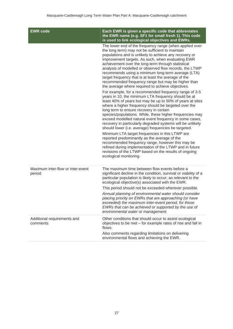
Macquarie-Castlereagh Long Term Water Plan Part A: Macquarie-Castlereagh catchment
27
EWR code Each EWR is given a specific code that abbreviates the EWR name (e.g. SF1 for small fresh 1). This code is used to link ecological objectives and EWRs.
The lower end of the frequency range (when applied over the long term) may not be sufficient to maintain populations and is unlikely to achieve any recovery or improvement targets. As such, when evaluating EWR achievement over the long-term through statistical analysis of modelled or observed flow records, the LTWP recommends using a minimum long-term average (LTA) target frequency that is at least the average of the recommended frequency range but may be higher than the average where required to achieve objectives.
For example, for a recommended frequency range of 3-5 years in 10, the minimum LTA frequency should be at least 40% of years but may be up to 50% of years at sites where a higher frequency should be targeted over the long term to ensure recovery in certain species/populations. While, these higher frequencies may exceed modelled natural event frequency in some cases, recovery in particularly degraded systems will be unlikely should lower (i.e. average) frequencies be targeted.
Minimum LTA target frequencies in this LTWP are reported predominantly as the average of the recommended frequency range, however this may be refined during implementation of the LTWP and in future revisions of the LTWP based on the results of ongoing ecological monitoring.
Maximum inter-flow or inter-event period
The maximum time between flow events before a significant decline in the condition, survival or viability of a particular population is likely to occur, as relevant to the ecological objective(s) associated with the EWR.
This period should not be exceeded wherever possible.
Annual planning of environmental water should consider placing priority on EWRs that are approaching (or have exceeded) the maximum inter-event period, for those EWRs that can be achieved or supported by the use of environmental water or management.
Additional requirements and comments
Other conditions that should occur to assist ecological objectives to be met – for example rates of rise and fall in flows.
Also comments regarding limitations on delivering environmental flows and achieving the EWR.

Macquarie-Castlereagh Long Term Water Plan Part A
28
4.2 Flow threshold estimates for flow categories in the regulated Macquarie-Castlereagh
Table 8 Flow threshold estimates for flow categories in the regulated Macquarie-Castlereagh WRPA
Note: All units ML/d, except total volume which is shown as ML.
Planning unit Gauge Very low flow Baseflow Destratify-
ing flow
Freshes Overbank
BF1&2 BF3 Small Large Small Medium Large
REGULATED CUDGEGONG RIVER
Cudgegong River @ Yamble Bridge
421019 5 40 4024 TBD24 200 1,000
12,000
(not deliverable)6
Not applicable – PU not characterised by extensive river red gum forests on the wider floodplain
REGULATED MACQUARIE RIVER
Burrendong to Baroona (@Dubbo)
421001 1 @ Baroona 200 20024 TBD24 500 6,000
65,000
(not deliverable)6
Not determined – non-riparian river red gum forests & woodlands are less extensive in this PU
Not applicable – PU not characterised by extensive black box or coolibah woodlands on the wider floodplain
Baroona to Warren (@ Warren Weir)
421004 1 200 20024 TBD24 450 4,000
12,000
(not deliverable)6
16,000 18,000
24 Where threshold estimates are given, these are provisional. Further work is required to develop thresholds for refuge pools - see Table 22

Macquarie-Castlereagh Long Term Water Plan Part A
29
Planning unit Gauge Very low flow Baseflow Destratify-
ing flow
Freshes Overbank
BF1&2 BF3 Small Large Small Medium Large
Warren to Macquarie Marshes (@combined Marebone Break & Macquarie River below Marebone gauges)
421088 + 421090
1 100 3024 TBD24 350 2,500 4,000 5,500 Not determined
MACQUARIE MARSHES
Northern and Southern river flow thresholds (Macquarie River downstream Marebone & Oxley Station)
Macquarie River downstream Marebone (421090)
10
65
30
TBD24 300 1,000
2,900
Oxley Station
(421022)
5 20 24 2600
Whole of Macquarie Marshes wetland flows – Northern, Southern & Eastern Marshes
(@combined Macquarie
421088 + 421090
For core wetlands (small overbank/ wetland 1): 60,000 ML over 90 days25
For wetland non-woody
250,000 ML within 120 days25
440,000 ML within 150 days25
25Volume required will vary between years depending on antecedent conditions

Macquarie-Castlereagh Long Term Water Plan Part A
30
Planning unit Gauge Very low flow Baseflow Destratify-
ing flow
Freshes Overbank
BF1&2 BF3 Small Large Small Medium Large
River & Marebone Break below Marebone gauges)
vegetation (small overbank/ wetland 4): 100,000 ML within 90 days25
Eastern Marsh wetland flow (Gum Cowal @ Bifurcation)
421146
8,000 ML provided at above 400 ML/d, within 40-day period25
Covered by whole of Marshes flow – see above.
LOWER MACQUARIE RIVER
Lower Macquarie (@ Bells Bridge (Carinda))
421012
Evidence of
flow at confluence
with Barwon.
Nominally >10 ML/d
@Bells Bridge
65 NA NA 140 700 1,900 Not determined
Not determined
LOWER MARTHAGUY CREEK
Marthaguy Creek (@ Carinda)
421011 Evidence of flow at confluence with Macquarie
20 TBD24 TBD24 70 800 2,900 Not determined
Not determined

Macquarie-Castlereagh Long Term Water Plan Part A
31
Figure 8 Schematic of the main watercourses and streamflow gauges used for EWRs (not to scale)

Macquarie-Castlereagh Long Term Water Plan Part A
32
4.3 Catchment-scale EWRs for Macquarie-Castlereagh
Table 9 Catchment-scale EWRs for Macquarie-Castlereagh WRPA
Flow category26 Ecological objectives26 Ideal flow timing26,27
Duration26,28 Frequency (LTA freq.)26,29
Maximum inter-event period26,30
Additional requirements/comments26
Cease-to-flow CtF1
Native Fish: NF1 – Survival & condition (all species)
Ecosystem Functions: EF1, 2 – refuge habitat
In line with historical low season flow31
In line with natural, unless key refuges endangered
No greater than natural31
N/A
When restarting flows, avoid harmful water-quality impacts, such as de-oxygenated refuge pools.
Very-low flow VLF
Native Fish: NF1 - Survival & condition (all species)
Ecosystem Functions: EF1, 2 – refuge habitat
Any time No less than natural31
No less than natural31
No greater than natural31
Flow at gauge sufficient to maintain flow to end of planning unit
Baseflow BF1
Native Fish: NF1, 2, 3, 4, 5, 6, 7, 8, 9 – condition & movement (all species)
Native Vegetation: NV1 – in-channel
Any time
No less than natural31 – maintain refuge habitat & support connectivity
No less than natural31
As required during dry periods
Minimum depth of 0.3 m to allow fish passage
26 See Table 7 for definitions of terms and explanatory text for EWRs
27 Recommended ideal timing for native fish is linked to maximising spawning and recruitment outcomes based on known spawning seasons. Ideal timings where the purpose is for dispersal and/or productivity have also been recommended; however, these may occur anytime with a movement and/or condition outcome still expected from native fish. 28 Recommended minimum duration for native fish is linked to maximising spawning and recruitment outcomes based on known egg hatch time and morphology. 29 Recommended ideal frequency for native fish is linked to providing conditions that protect and improve native fish populations in heavily impacted systems. To achieve this recovery more frequent events that maximise native fish outcomes may be required. 30 Recommended ideal period between events for spawning and recruitment objectives is linked to the longevity of species, providing a guide to the maximum period between these outcomes before risk of significant population decline. Objectives related to in-channel dispersal and/or productivity have been set at annual frequencies to provide conditions that protect and improve native fish populations in heavily impacted systems. 31 Determined using pre-1966 observed data where a multi-decadal record exists or modelled natural where sufficient observed data lacking.

Macquarie-Castlereagh Long Term Water Plan Part A
33
Flow category26 Ecological objectives26 Ideal flow timing26,27
Duration26,28 Frequency (LTA freq.)26,29
Maximum inter-event period26,30
Additional requirements/comments26
Ecosystem Functions: EF1, 2, 3a
Other species (frogs): OS1
BF2
Native Fish: NF1, 2, 5, 6, 8 – Recruitment (riverine specialists, generalists)
Ecosystem Functions: EF1, 2, 3
September to March
In line with natural31
5–10 years in 10
(1 every 1–2 years)
2 years Minimum depth of 0.3 m to allow fish passage
BF3: stratifi-cation prevent-ion flow
Native Fish: NF1 – Survival & condition (all species)
Ecosystem Functions: EF1, 2 – refuge habitat
As required to avoid stratification during periods of identified high risk where a hypoxic bottom layer is likely to develop to an extent that it could produce hypoxic conditions in the entire water column should subsequent mixing occur. Requirement more likely during periods of extreme heat and low flow.
This flow would also help reduce the risk of fish mortality due to extremely high water temperatures.
Further work (see Table 22) is required to better identify risk periods, develop flow requirements and develop tools for PUs with fish refuges.
As these flows are to maintain water quality, weir level management (where relevant), natural flows, operational water and non-discretionary environmental water should be used in the first instance before considering the use of discretionary environmental water.
DSF flow must be provided in a manner which considers potential impacts from turning over refuge pools and initial water temperature increases from flows travelling over hot, dry river beds. Consult NSW DPI-Fisheries on interim flow protocols and in developing detailed future requirements
Destratifying flow
DSF
Native Fish: NF1 – Survival & condition (all species)
Ecosystem Functions: EF1, 2 – refuge habitat
As required to destratify refuge pools during periods of identified high risk where a hypoxic bottom layer has developed and could produce hypoxic conditions in the entire water column when mixed. Requirement more likely during periods of extreme heat and low flow.
Further work (see Table 22) is required to better identify risk periods, develop flow requirements and develop tools for PUs with fish refuges.

Macquarie-Castlereagh Long Term Water Plan Part A
34
Flow category26 Ecological objectives26 Ideal flow timing26,27
Duration26,28 Frequency (LTA freq.)26,29
Maximum inter-event period26,30
Additional requirements/comments26
(see recommended further work, Table 22).
Small fresh
SF1
Native Fish: NF1, 2, 3, 4, 5, 6, 7, 8, 9 – Dispersal / condition (all species)
Native Vegetation: NV1 – in-channel
Ecosystem Functions: EF1, 2, 3, 4, 5
October to April (but can occur any time)
10 days minimum
Annual (1 per year)
1 year
>20°C for October to April
Australian smelt >11°C
Minimum depth of 0.5 metres to allow movement of large fish
Can follow 2–3 weeks after ‘Large Fresh 2’ for increased likelihood of successful recruitment of fish, productivity & dispersal
Flow ideally up to 0.3 to 0.4 m/s (depending on channel form)
Maintain rate of fall within natural range
SF2
Native Fish: NF1, 2, 5, 6, 8 – Spawning (river specialists, generalists)32
Native Vegetation: NV1 – in-channel
Ecosystem Functions: EF2, 3, 4, 5
September to April
14 days minimum
5–10 years in 10
(75% of years)
2 years
>20°C; for river blackfish >16°C; for Murray cod September to December >18°C
Minimum depth of 0.5 metres to allow movement of large fish
32 Requires the flow to not exceed the large fresh threshold to avoid flushing of nests etc.

Macquarie-Castlereagh Long Term Water Plan Part A
35
Flow category26 Ecological objectives26 Ideal flow timing26,27
Duration26,28 Frequency (LTA freq.)26,29
Maximum inter-event period26,30
Additional requirements/comments26
Flow ideally up to 0.3 to 0.4 m/s (depending on channel form)
Maintain rate of fall within natural range
SF3
Native Fish: NF1, 2, 3, 4, 5, 6, 7, 8, 9 – Dispersal / condition (all species)
Native Vegetation: NV1 - in–channel
Ecosystem Functions: EF1, 2, 3, 4, 5, 7 – connectivity between catchments
October to April (but can occur any time)
28 days minimum
Initial flow: Approx. 5–18 months following fish breeding event in Barwon Darling or a large fresh at Wilcannia33.
Follow up flow within 12 months of initial flow to allow further fish movement between catchments
4 years
Minimum depth of 0.5 metres to allow movement of large fish
Maintain rate of fall within natural range
Large fresh LF1 Native Fish: NF1, 2, 3, 4, 5, 6, 7, 8, 9 – Dispersal / condition (all species)
Ideally July to September but can
5 days minimum
5–10 years in 10
2 years Flow for pre-spawning condition
33 Trigger is a demonstrated breeding event with young of year in the Barwon Darling, or, if there has been insufficient monitoring to confirm/deny this, the trigger is a large fresh at Wilcannia. Monitoring results noted in Stuart and Sharpe (2017) Towards a Southern Connected Basin flow plan: Connecting rivers to recover native fish communities, indicate that a flow of approximately 10,000 ML/day at Wilcannia coincides with breeding events for golden perch. The 5-month delay following the breeding event is to allow recruits to reach sufficient maturity to move up into the Macquarie.

Macquarie-Castlereagh Long Term Water Plan Part A
36
Flow category26 Ecological objectives26 Ideal flow timing26,27
Duration26,28 Frequency (LTA freq.)26,29
Maximum inter-event period26,30
Additional requirements/comments26
Native Vegetation: NV1, 3 (in-channel)
Function: EF2, 3, 4, 5, 6, 7
occur anytime
(75% of years)
Minimum depth of 2 metres to cover in-stream features & trigger response from fish
Flow ideally 0.3 to 0.4 m/s (depending on channel form)
Maintain rate of fall within natural range
LF2
Native Fish: NF1, 4, 6, 9 – spawning (flow pulse specialists)
Native Vegetation: NV1, 3 (in-channel)
Function: EF2, 3, 4, 5, 6, 7
October to April
5 days minimum
3–5 years in 10 years (40% of years)
4 years
Rapid rise (comparative to natural rates)
>17°C
Can be followed by ‘Small Fresh 1’ for increased likelihood of successful recruitment of fish, productivity & dispersal
Minimum depth of 2 metres to cover in–stream features & trigger response from fish
Flow ideally 0.3 to 0.4 m/s (depending on channel form)
Maintain rate of fall within natural range
Overbank /
Wetland Small34
OB/WS1 (core wetland)
Native Fish: NF1
Native Vegetation: NV2
Waterbirds: WB1, 2, 5
Any time In line with natural (no less than natural)31
9–10 years in 10
(95% of years)
18 months
34 Flows greyed to denote that discretionary water delivery seeks to avoid floodplain infrastructure and cultivated areas. Otherwise provided by tributary events or flood mitigation zone releases.

Macquarie-Castlereagh Long Term Water Plan Part A
37
Flow category26 Ecological objectives26 Ideal flow timing26,27
Duration26,28 Frequency (LTA freq.)26,29
Maximum inter-event period26,30
Additional requirements/comments26
Ecosystem Functions: EF1 – protection of core wetland areas
Other Species (Frogs): OS1
OB/WS2
Native Fish: NF1, 3, 7 – spawning (floodplain specialists)
Native Vegetation: NV2, 3, 4a – non-woody wetland vegetation, riparian river red gum
Waterbirds: WB1, 2, 5 – habitat
Ecosystem Functions: EF2, 3, 4, 5, 6, 7 - connectivity, productivity
Other Species (Frogs): OS1 – habitat
October to April
10 days minimum
5 years in 10
(50% of years)
4 years
>22°C
Ideally, recruitment flow 2-4 weeks after spawning flow
OB/WS3
Native Fish: NF1, 2, 3, 4, 5, 6, 7, 8, 9 – dispersal & condition (all species)
Native Vegetation: NV2, 3 – riparian river red gum communities
Ecosystem Functions: EF2, 3, 4, 5, 6, 7 – channel forming, lateral connectivity, productivity
Other Species (Frogs): OS1 – habitat
Ideally Sep to Feb but can occur anytime
5 days minimum for fish dispersal
In line with natural31 for riparian river red gum communities
2–3 years in 10
(25% of years)
5 years

Macquarie-Castlereagh Long Term Water Plan Part A
38
Flow category26 Ecological objectives26 Ideal flow timing26,27
Duration26,28 Frequency (LTA freq.)26,29
Maximum inter-event period26,30
Additional requirements/comments26
OB/WS4
(Non- woody vegetation zone)
Native Fish: NF1, 2, 3, 4, 5, 6, 7, 8, 9 – dispersal & condition (all species)
Native Vegetation: NV2, 3, 4a – Non-woody vegetation in wetlands, river red gum forest
Waterbirds: WB1, 2, 3, 5 – habitat
Ecosystem Function: EF1, 2, 3, 4, 5, 6, 7 – core wetland habitats, connectivity to floodplain, productivity
Other Species (Frogs): OS1, 2 – small-scale recruitment
Aug to Mar, with benefits also outside that period including by providing off-season bird foraging habitat
3–8 months for wetlands. Refers to the persistence of standing water, flow can be shorter. For streamside areas, only duration to fill the soil profile, depressions/ billabongs required.
8–9 years in 10
(95% of years)
2 years
Ideally provide slow draw down for shallow muddy edges for bird foraging habitat.
Overbank /
Wetland Medium34
(river red gum
woodland zone)
OB/WM
Native Fish: NF1, 3, 7 – floodplain specialist
Native Vegetation: NV2, 4a, 4b, 4e river red gum, lignum
Waterbirds: WB1, 2, 3, 4, 5 – habitat & potential small-scale breeding
Ecosystem Functions: EF2, 3, 4, 5, 6, 7 – connectivity to floodplain, productivity
Other Species (Frogs): OS1, 2 – recruitment
Aug to Mar, with benefits also outside that period including by providing off-season bird foraging habitat
3–6 months for wetlands.
Refers to the persistence of standing water, flow can be shorter.
For streamside areas, only duration to fill the soil profile, depressions/ billabongs required
5 years in 10
(50% of years)
4 years
Ideally provide slow draw down for shallow muddy edges for bird foraging habitat.
Ideally have 2 consecutive years of inundation where consolidation of river red gum recruits is desired

Macquarie-Castlereagh Long Term Water Plan Part A
39
Flow category26 Ecological objectives26 Ideal flow timing26,27
Duration26,28 Frequency (LTA freq.)26,29
Maximum inter-event period26,30
Additional requirements/comments26
Overbank /
Wetland Large35 (coolibah / black
box zone)
OB/WL
Native Fish: NF1, 3, 7 – floodplain specialist
Native Vegetation: NV2, 4a, 4b, 4c, 4d, 4e – black box, coolibah & lignum Waterbirds: WB1, 2, 3, 4, 5 – large-scale breeding (colonial & non-colonial) & habitat
Ecosystem Functions: EF2, 3, 4, 5, 6, 7 – connectivity to floodplain, productivity
Other Species (Frogs): OS1, 2 – recruitment
Aug to Mar with benefits also outside that period including by providing off-season bird foraging habitat
3–6 months for wetlands.
Refers to the persistence of standing water, flow can be shorter.
For streamside areas, only duration sufficient to fill the soil profile, depressions/ billabongs required.
2 to 3 years in 10
(25% of years)
5 years (up to 10 years for outer coolibah/black box areas)
Ideally provide slow draw down for shallow muddy edges for bird foraging habitat.
35 Greyed to show overbank and wetland flows of this size rely on large tributary events or flood mitigation zone releases.

Macquarie-Castlereagh Long Term Water Plan Part A
40
4.4 Important flow regime characteristics needed to
deliver LTWP objectives
Table 10 Important flow regime characteristics needed to deliver LTWP objectives
Ecological objective Important flow regime characteristics
NATIVE FISH OBJECTIVES36
NF1: No loss of native fish species
Cease-to-flow: durations that are not longer than the persistence of water of sufficient volume & quality in key larger river pool refuges for survival of native fish.
Very low flows (VLF), baseflows (BF1 & 3) & destratifying flows (DSF): for the survival & maintenance of native fish condition as these flows maintain adequate water quantity & quality (dissolved oxygen, salinity & temperature) in refuge pools.
Baseflows & small freshes: deep enough along the whole channel to allow fish movement (at least 0.3 m above cease-to-flow for small & moderate bodied fish [Gippel 2013; O’Conner et al. 2015] & 0.5 m for large bodied fish [Fairfull & Witheridge 2003; Gippel 2013; O’Conner et al. 2015]).
A baseflow (BF2): preferably between September & March with an annual or biannual frequency to enhance recruitment outcomes.
A small fresh (SF3): ideally from October to April, but can occur anytime to provide connectivity with the Barwon. This flow should be timed 5 to 18 months after a breeding event in the Barwon-Darling, which is indicated by a large fresh in that system. A follow-up flow 12 months later will allow further recruits from the Barwon to replenish fish populations in the Macquarie-Castlereagh. Duration of 28 days to allow fish to respond to the flow, enter the lower end of the Macquarie-Castlereagh system & work their way up to refuge waterholes higher in the system.
A large fresh (LF1): of at least 5 days duration & occurring ideally between July & September (but can occur at any time) to promote dispersal & pre-spawning condition for all native fish species 5 to 10 years in 10. The large fresh should trigger some primary productivity providing food resources & improving fish condition prior to the spring/summer spawning season. Flow velocities of >0.3 m/s are ideal to trigger fish movement.
Wetland/overbank flows (OB/WS1): to maintain core wetlands, including off-channel waterholes. Alternative watering actions (e.g. pumping) may be required to support floodplain habitats under very dry, dry & moderate scenarios to prevent habitat for floodplain specialists from drying out.
Small overbank & wetland inundating flows (OB/WS3): ideally from September to February, for at least 5 days & occurring 2 to 3 years in 10 (with a maximum inter-event period of 5 years) is also required to support condition & movement/dispersal outcomes of all native fish groups.
36 Important flow regime characteristics for all native fish objectives are based on NSW DPI 2015.

Macquarie-Castlereagh Long Term Water Plan Part A
41
Ecological objective Important flow regime characteristics
Larger flows that inundate off-stream habitat can also promote growth & recruitment through increased floodplain productivity & habitat availability. Larger flows that connect low-lying wetlands provide important habitat to support strong survivorship & growth of juveniles.
NF2: Increase the distribution & abundance of short to moderate-lived generalist native fish species
In addition to the flows listed above for all native fish species, other important aspects of the flow regime for generalists include:
• Regular (ideally annual) spawning & recruitment events for the persistence of short-lived species. Spawning can occur independent of flow events, however, small freshes (SF2) enhance spawning. Events should occur during the warmer months of September to April, 5 to 10 years in 10, with a minimum event duration of 14 days for egg development & hatching. Multiple freshes during the spawning season provides flexibility in species response & opportunities for multiple spawning events.
•
NF3: Increase the distribution & abundance of short to moderate-lived floodplain specialist native fish species
In addition to the flows listed above for all native fish species, other important aspects of the flow regime for floodplain specialists include:
• Overbank & wetland inundating flows (OBWS2) during the warmer months of October to April provide spawning habitat & floodplain productivity benefits to support fish growth. Overbank & wetland flows should inundate floodplain habitats for at least 10 days to allow for egg development & occur at least 5 years in 10, with a maximum inter-event period of 4 years. This period will depend on the persistence of floodplain habitats & time between reconnection to mainstem waterways. Flows should be of a long enough duration to support isolated populations. Water temperatures should be above 22°C.
• Recruitment is enhanced by subsequent flows events (large fresh, bankfull or overbank & wetland inundating flows) 2–4 weeks after spawning flows. Most floodplain specialist species require spawning & recruitment every 1 to 2 years for population survival.
NF4: Improve population structure for moderate to long-lived flow pulse specialist native fish species
In addition to the flows listed above for all native fish species, other important aspects of the flow regime for flow pulse specialists include:
• A large fresh (LF2) between October to April for a minimum of 5 days for spawning. This is needed 3 to 5 years in 10 with a maximum inter-event period of 4 years. Spawning is triggered by a rapid rise or fall in flow (relative to natural rates) when temperatures are greater than 17°C. In lowland systems, spawning responses are enhanced by substantial flow depths of at least 2 m to cover in-stream features & high flow velocities of greater than 0.3 m/s. Integrity of flow events need to be maintained over long distances (10s to 100s of km) to maximise the capacity for in-stream spawning, downstream dispersal by drifting eggs & larvae & movements by adults & juveniles.
NF5: Improve population structure for moderate to long-lived riverine specialist native fish species
In addition to the flows listed above for all native fish species, other important aspects of the flow regime for riverine specialists include:
• Spawning usually occurs annually, independent of flow events. However, small freshes (SF2) may enhance spawning by promoting ecosystem productivity & inundating additional spawning habitat. Events should occur during the warmer months of September to April, 5 to 10 years in 10. Water temperatures should be >20°C. River blackfish may spawn in lower water temperatures of >16°C & Murray cod in >18°C. Murray cod have a narrower spawning window of September to December. For nesting species (e.g.

Macquarie-Castlereagh Long Term Water Plan Part A
42
Ecological objective Important flow regime characteristics
Murray cod & eel-tailed catfish) preventing rapid drops in water levels (that exceed natural rates of fall) during, & for a minimum of 14 days after, spawning is important to prevent fish nests from drying.
• Recruitment is enhanced by a secondary flow pulse (large fresh, bankfull or overbank) for dispersal & access to nursery habitat in low-lying wetland habitats.
• Overall, riverine specialists prefer hydraulically complex flowing streams containing submerged structure (snags & benches) that provides cover & spawning habitat. Flow variability through the delivery of small & large freshes, bankfull & overbank flows enhance the availability of diverse habitat, enhances growth & condition of larvae & juveniles & provides connectivity for dispersal between habitats.
NF6: A 25% increase in abundance of mature (harvestable sized) golden perch & Murray cod
Flow requirements of golden perch (flow pulse specialist) & Murray cod (riverine specialist) are outlined above under NF4 & NF5, respectively.
Small freshes (SF3) which connect with the Barwon are particularly important for golden perch to provide movement pathways for recruits from breeding events.
NF7: Increase the prevalence &/or expand the population of key short to moderate-lived floodplain specialist native fish species into new areas (within historical range)
Flow requirements of floodplain specialists are outlined for NF3.
Expanding populations into new areas will be particularly dependent on dispersal flows, which include large freshes (LF1), & overbank & wetland inundating flows (OB/WS3).
Complementary actions such as conservation stocking &/or translocation may be required to support these watering actions. Infrastructure based watering actions (e.g. pumping) may also be required to support floodplain habitats under very dry, dry & moderate scenarios to ensure no loss of species for floodplain specialists (e.g. to prevent wetlands with threatened fish species from drying out).
NF8: Increase the prevalence &/or expand the population of key moderate to long-lived riverine specialist native fish species into new areas (within historical range)
Flow requirements of riverine specialists are outlined for NF5.
Expanding populations into new areas will be particularly dependent on dispersal flows, which include large freshes (LF1), overbank & wetland inundating flows (OB/WS3).
Complementary actions such as conservation stocking &/or translocation may be required to support these watering actions.
NF9: Increase the prevalence and/or expand the population of key moderate to long-lived flow pulse specialists native fish species into new areas (within historical range)
Flow requirements of flow pulse specialist are outlined for NF4.
Expanding populations into new areas will be particularly dependent on dispersal flows, which include large freshes (LF1), overbank & wetland inundating flows (OB/WS3) and flows that connect with the Barwon (SF3).

Macquarie-Castlereagh Long Term Water Plan Part A
43
Ecological objective Important flow regime characteristics
NATIVE VEGETATION OBJECTIVES37
NV1: Maintain the extent & viability of non-woody vegetation communities occurring within & closely fringing channels
Non-woody, inundation tolerant plants occurring on the channel bed, banks, bars & benches require regular wetting & drying to complete life cycles. Variable size & duration of flows including baseflows, variable size freshes & bankfull flows throughout the year will promote diverse communities. Regular inundation will also encourage a dominance of native species over exotic species, as the latter tend to be less tolerant of inundation (Catford et al. 2011). Increased cover of non-woody, inundation tolerant vegetation on banks is likely to stabilise bank material & therefore reduce the risk of excessive bank erosion.
Inundation of banks during late winter & early spring by freshes & bankfull flows replenishes soil moisture to promote growth during spring. Prolonged submergence of some amphibious species (e.g. especially if there are continuous high flows) may have detrimental impacts on survival.
Small freshes in summer & autumn are important for replenishing soil moisture in river banks to ensure survival & maintenance.
NV2: Maintain the extent & viability of non-woody vegetation communities occurring in wetlands & on floodplains
Overbank & wetland inundating flows (OB/WS1, 4): to inundate wetlands for 3 or more months, ideally between August & March, but can occur anytime.
The required duration & frequency varies widely by species. Highly water-dependent, amphibious species such as water couch, spike-rush, & cumbungi prefer inundation for 3 to 8 months, 8 to 10 years in 10. The maximum period between events is 2 years. Some amphibious damp species such as floodplain herbs, grasses & sedges that require less frequent (3 to 10 years in 10) & shorter duration (2–4 months) inundation.
Other overbank & wetland flows also provide benefit.
NV3: Maintain the extent & maintain or improve the condition of river red gum communities closely fringing river channels
Large freshes (LF1, 2): to recharge alluvial aquifers & soil moisture in the riparian zone & maintaining deep rooted vegetation between inundation events.
Overbank flows & larger wetland inundating flows (particularly OB/WS3): to inundate the fringing riparian zone.
The general condition of riparian vegetation will benefit from inundation or groundwater recharge anytime of the year, with inundation around every 3 years.
NV4: Maintain the extent & maintain or improve the condition of native
River red gum
forest & woodland
Overbank & wetland inundating flows (OB/WS4 & OB/WM): to inundate vegetation, ideally between 2 & 7 months during September to February. Inundation needs to occur at least 3 years in 10 years, with greater frequency for forested areas.
Watering in the year following a maintenance flow will support the survival of seedlings from the previous year in areas where recruitment is desired. Ideally between August to November
37 Important flow regime characteristics for all native vegetation objectives are based on Bowen, S. pers comms, Cassanova 2015, Roberts & Marston 2011, Roberts & Marston 2000, and Rogers & Ralph 2011.

Macquarie-Castlereagh Long Term Water Plan Part A
44
Ecological objective Important flow regime characteristics
woodland & shrubland communities on floodplains
Lignum shrubland
Overbank & wetland inundating flows (OB/WM & OB/WL): to maintain condition. For at least 3 months, at a frequency of 3 or more years in 10 & a maximum period between events of 4 years.
Regeneration, generally via vegetative expansion requires more frequent inundation (3 to 5 years in 10), for 1 or more months, ideally between September to February.
Black box woodland
Large overbank & wetland inundating flows (OB/WL): to maintain condition, with inundation for 3 to 6 months, at a frequency of 2 to 3 years in 10 & a maximum period between events of 5 years. Regeneration requires watering for 1 to 2 months ideally 5 years in 10.
Coolibah woodland
Large overbank & wetland inundating flows (OB/WL): to maintain condition, with inundation for 2 weeks to 2 months, 1 to 2 years in 10 & a maximum period between events of 10 years. For regeneration a duration of 1 to 2 months 5 years in 10 between August & February is required.
WATERBIRD OBJECTIVES38
WB1: Maintain the number & type of waterbird species
Overbank & wetland inundating flows (OB/WS1, 2, 4; OB/WM; OB/WL): to provide refuge, support feeding & breeding habitat (see WB2, 3, 4) & maintain habitat condition (WB5). Overbank & wetland inundating flows, preferably delivered in spring-summer, that inundate a mosaic of floodplain habitats including non-woody floodplain vegetation, open shallow waterbodies & deep lagoons will provide feeding habitat for a range of waterbird species including open water foragers, herbivores, emergent vegetation dependent species, large waders, wetland generalists & small waders (including migratory shorebird species). Where there is gradual draw-down of habitats over late summer-autumn this can extend feeding habitat available for migratory & resident shorebird species (small waders).
WB2: Increase total waterbird abundance across all functional groups
Overbank & wetland inundating flows (OB/WS1, 2, 4; OB/WM; OB/WL): as in WB1 provide seasonal (spring–summer) inundation with gradual draw-down over summer into autumn to provide feeding & breeding habitat (WB3, 4) & maintain the habitat condition (WB5).
Where possible to coordinate, these flows should be delivered to compliment events in neighbouring catchments to provide benefits to waterbird populations by providing habitat across a larger area of northern Murray-Darling Basin. Follow-up overbank & wetland inundating flows in years following large breeding events in the Macquarie Marshes & neighbouring catchments in the northern Murray-Darling Basin will also promote the survival of juvenile birds & contribute to increased waterbird populations.
WB3: Increase opportunities for non-colonial waterbird breeding
Overbank & wetland inundating flows (OB/WS1, 2, 4; OB/WM; OB/WL): to inundate floodplain habitats for more than 3 months. Spring & summer (preferably September to March) is the ideal season, with opportunistic breeding in autumn & winter.
Habitat availability for non-colonial species will increase with increasing magnitude (both extent & duration of inundation) of overbank & wetland inundating flows. Also relies on maintaining (& in some cases
38 Important flow regime characteristics for all waterbird objectives are based on Brandis 2010, Brandis & Bino 2016, Rogers & Ralph 2011, and Spencer 2017.

Macquarie-Castlereagh Long Term Water Plan Part A
45
Ecological objective Important flow regime characteristics
improving) the condition of key native vegetation types that provide breeding & foraging habitats (see WB5).
WB4: Increase opportunities for colonial waterbird breeding
Overbank & wetland inundating flows (OB/WM; OB/WL): to inundate active colony sites & surrounding foraging habitat for 3 or more months to ensure successful completion of colonial waterbird breeding (from egg laying through to fledging including post-fledgling care) & access to key foraging habitats to enhance breeding success & the survival of young. Ideally September to March.
Larger wetland inundation flows (OB/WL) will support larger colonies & a greater number of breeding species with greater benefit to breeding success & increasing total abundance of waterbirds (WB2, WB3). These large overbank events are required on average 2 to 3 years in 10 years, with a maximum inter-event period of 5 years (ideally 4). Medium wetland inundation flows (OB/WM) may support smaller colonies (500 nests) & should ideally occur 5 years in 10.
WB5: Maintain the extent & improve condition of waterbird habitats
Colonial waterbird species are dependent on relatively few sites across the major wetlands of the Murray Darling Basin including known sites in the Macquarie Marshes. These include sites provide nesting habitat consisting of river red gum, river cooba, coolibah, lignum, reedbeds &/or cumbungi.
Overbank & wetland inundating flows (OB/WS1, 2, 4; OB/WM; OB/WL) are needed to maintain the extent & condition of these vegetation communities in these discrete wetland sites. This ensures that sites are in event-ready condition when medium & large events (OB/WM; OB/WL) initiate colonial waterbird breeding events. These flows, particularly the smaller overbank & wetland inundating flows (OB/WS1,2,4), will also support a broader range of foraging habitats in the Macquarie Marshes, including spike-rush sedgelands, marsh grasslands, lignum shrublands & open lagoons. The required duration & frequency of overbank flows to support these vegetation types are outlined under the native vegetation objectives.
PRIORITY ECOSYSTEM FUNCTIONS OBJECTIVES39
EF1: Provide & protect a diversity of refugia across the landscape
Cease-to-flow: durations that are not longer than the persistence of water of sufficient volume & quality in key larger river pool refuges.
Very low flows (VLF) baseflows (BF1 & 3) & destratifying flows (DSF): to maintain adequate water quantity & quality (dissolved oxygen, salinity & temperature) in refuge pools. VLF and BF1 flows are required every year at a frequency that is no less than natural & are especially important during dry times. BF3 and DSF flows are required where there is a risk of stratification leading to severe hypoxic conditions.
Small freshes: when restarting flows after a cease-to-flow event, larger magnitude flows such as these may be required to prevent detrimental water quality outcomes (as poor-quality water from the bottom of pools is mixed through the water column, organic matter from dry stream beds may cause a decrease in oxygen as it is broken down and in summer hot stream beds may elevate the temperature of the flow front).
Wetland/overbank flows (OB/WS1): To maintain core wetlands, including off-channel waterholes. Alternative watering actions (e.g. pumping) may be required to support floodplain habitats under very dry,
39 Important flow regime characteristics for all priority ecosystem function objectives are based on Alluvium 2010.

Macquarie-Castlereagh Long Term Water Plan Part A
46
Ecological objective Important flow regime characteristics
dry & moderate scenarios to prevent habitat for floodplain specialists from drying out.
EF2: Create quality instream & floodplain habitat
The full range of in-channel & overbank flow types are required to maintain quality instream & floodplain habitat. Variable in-channel flows (baseflows – bankfull flows) will provide a diversity of physical & hydraulic habitats. With increasing magnitude of flows, greater areas of the channel are inundated (e.g. benches, bars, snags & banks at different elevations in the channel). Baseflows & small freshes provide areas of slackwater (slow flowing) habitat, while large freshes provide deeper & faster flowing habitats. Small & large freshes are important for flushing fine sediment from pools, de-stratifying pools (along with specific destratifying flows) & maintaining geomorphic features such as benches & bars. Bankfull flows are important for geomorphic maintenance of all channel features.
To protect banks from excessive erosion it is important to maintain rates of fall that do not exceed natural rates of fall for all regulated deliveries. Slow rates of fall allow water to drain from the bank slowly, preventing mass failure of the banks. Maintaining slow rates of fall is particularly important when flows are in the lower third of the channel, to protect the ‘toe’ of the bank, which supports the rest of the bank above.
Bank notching can be avoided by varying flows (avoiding holding flows constant for too many consecutive days) & targeting different peak heights for freshes.
Wetland/overbank flows (OB/WS1-4; OB/WM; OB/WL): to provide floodplain & wetland habitat for native fish, waterbirds & other aquatic fauna.
EF3a: Provide movement & dispersal opportunities within catchments for water-dependent biota to complete lifecycles
Providing longitudinal connectivity is critical for migration, recolonisation following disturbance events, allowing species to cross shallow areas, & dispersal of larvae to downstream habitats. In-channel flows of adequate depth & duration (baseflows & freshes) are important to allow for the movement of aquatic & riparian fauna & flora along rivers & creeks. For example, flows of at least 0.3 m are needed to allow medium sized native fish to move along a channel. Physical barriers, such as dams & weirs, have introduced additional barriers throughout the Macquarie-Castlereagh, making large freshes & occasionally small overbank flows important for overcoming these man-made structures where fishways are not present.
Wetland/overbank flows (OB/WS1-4; OB/WM; OB/WL): to provide lateral connectivity to floodplain & wetland habitat.
EF3b: Provide movement & dispersal opportunities between catchments for water-dependent biota to complete lifecycles
Freshes & baseflows: to connect the Lower Macquarie/Marthaguy, Marra, Castlereagh & Bogan to the Barwon are important to allow the movement of fish & other biota between the catchments & allow re-colonisation & the replenishment of populations.
Particularly small fresh (SF3): see description of this flow under NF1.
EF4: Support instream & floodplain productivity
Freshes: to flush organic matter from stream banks & anabranches & drive small pulses of productivity.
Wetland/overbank flows (OB/WS1-4; OB/WM; OB/WL): to inundate the floodplain & supporting large scale productivity, which in turns drives aquatic food webs both on the floodplain & in-stream. Primary productivity includes growth of algae, macrophyte, biofilms & phytoplankton, which in turn drives secondary productivity (zooplankton, macroinvertebrates, fish larvae etc.).

Macquarie-Castlereagh Long Term Water Plan Part A
47
Ecological objective Important flow regime characteristics
EF5: Support mobilisation & transport of sediment, carbon & nutrients along channels, between channels & floodplains, & between catchments
Freshes: for mobilising organic matter & sediment from in-channel surfaces (e.g. leaf litter that has accumulated on bars, benches & banks during low flows). This material is transported downstream or deposited in other parts of the channel where it is utilised, in the case of nutrients & carbon, to drive primary productivity, or in the case of sediment, for channel maintenance (e.g. to replenish banks & benches).
Wetland/overbank flows (OB/WS1-4; OB/WM; OB/WL): for transferring nutrients & carbon from the floodplain to the channel.
EF6: Support groundwater conditions to sustain groundwater-dependent biota
Large freshes (LF1, 2) & wetland/overbank flows (OB/WS1-4; OB/WM; OB/WL): to contribute to recharging shallow groundwater aquifers in areas where there is a surface-groundwater connection. This recharge can reduce the salinity of shallow aquifers & raise water tables, providing critical soil moisture for deep-rooted vegetation in the riparian zone & on low-lying floodplains.
EF7: Increase the contribution of flows into the Murray & Barwon-Darling from tributaries
Flows from the Macquarie-Castlereagh to provide movement & dispersal opportunities between catchments (see EF3b) will also contribute to important EWRs in the Barwon-Darling WRPA.
Protecting overbank flows (OB/WS2-4; OB/WM; OB/WL) will provide important flows & transfer nutrients & carbon from floodplains in the Macquarie-Castlereagh to the Barwon River.
OTHER SPECIES40
OS1: Maintain species richness & distribution of flow-dependent frog communities
In addition to actions which allow breeding (OS2) the flows below are important for survival & to maintain frog condition.
Cease-to-flow: durations that are not longer than the persistence of water of sufficient volume & quality in key larger river pool refuges.
Very low flows (VLF) & baseflows (BF1 & 3) and destratifying flows (DSF): to maintain adequate water quantity & quality (dissolved oxygen, salinity & temperature) in refuge pools.
Wetland/overbank flows: Flows to maintain core wetlands, including off-channel waterholes (OB/WS1) for refuge. Larger flows (OB/WS2-4, OBWM, OBWL) to maintain frog condition & habitat & allow dispersal.
OS2: Maintain successful breeding opportunities for flow-dependent frog species
Wetland/overbank flows (OB/WS4, OB/WM, OB/WL): to provide opportunities for breeding & recruitment (i.e. laying eggs & tadpole metamorphosis). Ideally every 1 to 2 years for 6 or more months (with a minimum of 4 months). Spring-summer breeders require flows ideally from October to March, while species with more flexible breeding are likely to benefit from flows arriving between July & April. A gradual rise & fall is likely to improve recruitment outcomes.
40 Important flow regime characteristics from J. Spencer and J. Ocock (DPIE, pers. comms. 2018)

Macquarie-Castlereagh Long Term Water Plan Part A
48
4.5 Changes to the flow regime
The flow regime in the Macquarie-Castlereagh WRPA has changed due to regulation and development in the catchment. The degree of change varies depending on the location within the catchment. This section:
• briefly describes key differences between the pre-development and post development flow regimes
• notes aspects of the current flow regime which impact on achieving EWRs in some PUs. This assists in identifying risks and framing priority management actions.
Figure 9 Burrendong Dam offtake tower with cold water curtain Photo: Tim Hosking/DPIE
Areas that are regulated or affected by regulated water
Differences in the flow regime between pre-development and post-development conditions are discussed below based on observations (where available) and modelled scenarios.
Observations assess changes in recorded flows prior to the 1967 completion of Burrendong Dam (‘pre-development’) compared to flows recorded after Windamere Dam’s 1983 completion (‘post-development’). However, note this may understate the effect of development because there was development prior to 1967 and further development occurred after 1984. Note also that different time periods are compared, so there will be differences due to natural variations between years, not just due to water use development.

Macquarie-Castlereagh Long Term Water Plan Part A
49
Modelled comparisons use modelled flows under a ‘without development’ scenario (without dams or extractions) and under a ‘current conditions’ scenario and compare these. NSW DPIE-Water undertook the modelling and analysis and presented it in the Risk Assessment for the Macquarie-Castlereagh Water Resource Plan Area (DPIE-Water in prep). Note the DPIE-Water comparisons were done prior to the development of the EWRs outlined in this plan (Section 4.3). They analyse baseflows, freshes and high/overbank flows41 based on the frequency of occurrence, and these flows may not line up precisely with the baseflows, freshes and overbank flow levels in the EWRs of this LTWP.
Cudgegong River between Windamere Dam and Burrendong
Modelling by DPIE-Water (in prep) shows that with development there has been a greater than 50% increase in baseflows at the expense of high and overbank flows. High and overbank flows have decreased in size by more than 50% at Rocky Waterhole, but this effect is lessened downstream at Yamble Bridge where the reduction is less than 50%, due to tributary contributions between Rocky Waterhole and Yamble Bridge.
Modelling shows a mixed effect on freshes, with an increase at Rocky Waterhole but a decrease at Yamble Bridge. Further work will be needed to determine the causes of this.
The seasonality of flows has also changed with median flows now higher in summer and lower in winter.
Macquarie River from Burrendong Dam to Warren Weir
As with the regulated Cudgegong, modelling by DPIE-W (in prep) shows that with development there has been a greater than 50% increase in baseflows at the expense of high and overbank flows. High and overbank flows have generally decreased in size by more than 50% down to Gin Gin, with less substantial decreases at Warren. The smaller size of the decrease downstream at Warren may be due to the natural reduction in ‘peakiness’ in flows lower in the catchment. This means that larger flows do not always show up in significantly higher peak flows, but in marginally higher peaks that last longer.
Modelling indicates that freshes have increased. Analysis of observed flows shows some differences between small freshes, which have generally increased at Dubbo and Warren Weir since development, and large freshes, which have decreased in frequency. The number of years LTWP large fresh EWRs (LF1 and LF2) are met has decreased by more than 30% at Dubbo. At Warren Weir the decrease is less pronounced, but still 11% for LF1 and 32% for LF2. It is also worth noting that although small freshes appear to have increased in frequency, these freshes now generally come from Burrendong Dam deliveries. These will have a different ecological value to natural rainfall/runoff induced freshes. These have different rates of rise and fall and durations and contain more organic matter and different sediment/chemical signatures. All of these aspects can serve as cues for aquatic biota to respond to.
The seasonality of flows has also changed with median flows now far higher in summer and lower in winter.
Macquarie Marshes flows
By the time flows reach the Macquarie Marshes, it appears that baseflows are no longer higher than pre-development times. Modelling by DPIE-Water (in prep) indicates a distinct decrease (greater than 50%). However, observations at Oxley show a less distinct reduction
41 Flows with an average return period of 1.5 years or more, and termed ‘high and infrequent flows’ in DPIE-Water (in prep).
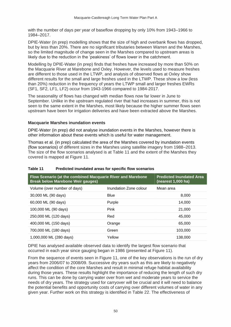
Macquarie-Castlereagh Long Term Water Plan Part A
50
with the number of days per year of baseflow dropping by only 10% from 1943–1966 to 1984–2017.
DPIE-Water (in prep) modelling shows that the size of high and overbank flows has dropped, but by less than 20%. There are no significant tributaries between Warren and the Marshes, so the limited magnitude of change seen in the Marshes compared to upstream areas is likely due to the reduction in the ‘peakiness’ of flows lower in the catchment.
Modelling by DPIE-Water (in prep) finds that freshes have increased by more than 50% on the Macquarie River at Marebone and Oxley. However, the levels used to measure freshes are different to those used in the LTWP, and analysis of observed flows at Oxley show different results for the small and large freshes used in the LTWP. These show a low (less than 20%) reduction in the frequency of years the LTWP small and larger freshes EWRs (SF1, SF2, LF1, LF2) occur from 1943-1966 compared to 1984-2017.
The seasonality of flows has changed with median flows now far lower in June to September. Unlike in the upstream regulated river that had increases in summer, this is not seen to the same extent in the Marshes, most likely because the higher summer flows seen upstream have been for irrigation deliveries and have been extracted above the Marshes.
Macquarie Marshes inundation events
DPIE-Water (in prep) did not analyse inundation events in the Marshes, however there is other information about these events which is useful for water management.
Thomas et al. (in prep) calculated the area of the Marshes covered by inundation events (flow scenarios) of different sizes in the Marshes using satellite imagery from 1988–2013. The size of the flow scenarios analysed is at Table 11 and the extent of the Marshes they covered is mapped at Figure 11.
Table 11 Predicted inundated areas for specific flow scenarios
Flow Scenario (at the combined Macquarie River and Marebone Break below Marebone Weir gauges)
Predicted Inundated Area (nearest 1,000 ha)
Volume (over number of days) Inundation Zone colour Mean area
30,000 ML (90 days) Blue 8,000
60,000 ML (90 days) Purple 14,000
100,000 ML (90 days) Pink 21,000
250,000 ML (120 days) Red 45,000
400,000 ML (150 days) Orange 65,000
700,000 ML (180 days) Green 103,000
1,000,000 ML (280 days) Yellow 138,000
DPIE has analysed available observed data to identify the largest flow scenario that occurred in each year since gauging began in 1986 (presented at Figure 11).
From the sequence of events seen in Figure 11, one of the key observations is the run of dry years from 2006/07 to 2008/09. Successive dry years such as this are likely to negatively affect the condition of the core Marshes and result in minimal refuge habitat availability during those years. These results highlight the importance of reducing the length of such dry runs. This can be done by carrying water over from wet and moderate years to service the needs of dry years. The strategy used for carryover will be crucial and it will need to balance the potential benefits and opportunity costs of carrying over different volumes of water in any given year. Further work on this strategy is identified in Table 22. The effectiveness of

Macquarie-Castlereagh Long Term Water Plan Part A
51
carryover is reliant on carryover being available in the resource assessment, so it is important that environmental water continues to maintain the same rights to access of carried over water as other water users.
Figure 10 Areas of the inundation in the Macquarie Marshes based on flow scenarios of different sizes listed in Table 11 from Thomas et al. (in prep)

Macquarie-Castlereagh Long Term Water Plan Part A
52
Figure 11 Occurrence of events in Macquarie Marshes, based on flow scenarios of different sizes listed in Table 10 from Thomas et al. (in prep).
Note the yellow zone is not shown and some larger green events would have been in the yellow zone.

Macquarie-Castlereagh Long Term Water Plan Part A
53
Lower Macquarie River
As the lowest reach of the Macquarie, this stretch is the most heavily impacted by the cumulative effects of river regulation and extraction (including floodplain harvesting, and licensed extraction from regulated and unregulated reaches of the river). Analysis of modelled flows by DPIE-Water (in prep) shows all flow classes (baseflows, freshes, high and overbank flows) have reduced by more than 20%.
Analysis of observed flows at the Macquarie River Bell’s Bridge (Carinda) gauge also shows similar reductions in flows between 1938-1966 and 1984-2017. Note there is further extraction downstream of this gauge, so the effect is likely to be even greater by the time flows reach the Barwon River.
Concerns to be highlighted are the:
• reduction in small and large freshes will impact on the connectivity to the Barwon for fish and other organisms.
• reduction in freshes and overbank flows, because these provide important flow volume contributions to the Darling-Barwon system.
Analysis of observed flows shows there has also been a change in the pattern of events between 1938-1966 and 1984-2017, with events now being shorter but more frequent. This may be because larger events are being broken up into several smaller ones through regulation or extraction during events.
Lower Marthaguy Creek
DPIE-Water’s (in prep) analysis of modelled flows shows that base flows and freshes have increased by over 50% at Carinda. This is downstream of the confluence with the Terrigal system, so contributions from deliveries to the Gum Cowal/Terrigal system may be providing increases here. However, analysis of observations at the Marthaguy Creek Carinda gauge show minimal change in the average number of days of baseflow from 1944–1966 to 1984–2017 (decrease from 116 to 113 days per year for flows reaching 20 ML/day). Analysis of observations for small and large freshes also show a reduction in the number of years that flows of the required duration to meet the EWR requirements (see Table 9). The differences between the modelled and observed assessments may be due differences in flow rates being assessed.
Modelling by DPIE-Water (in prep) also shows that high and overbank flows with average return periods of 1.5 and 2.5 years have decreased in size by more than 20%, with decreases also seen in larger 1-in-5 year floods, although the reduction is less than 20%. The lower Marthaguy Creek provides flows and connectivity to the Barwon River (via the Lower Macquarie) and so reductions in flows from the Marthaguy also have wider implications.
Marra Creek
Key gauges in this creek (at Carinda Road and at Billybingbone Bridge) only begin in the 1980’s so there is no pre-development observed data available. This makes it difficult to determine the type and degree of effect in this system. However, because high flows in Macquarie River have reduced it is possible to make inferences from this. The Marra Creek’s natural off-take channel (or ‘break’) starts upstream of Marebone Weir and has a commence-to-flow of about 3200 ML/day (Torrible et al. 2011). Modelling results presented by Torrible et al. (2011) support this, showing that the pre-development one-in-two year flood now occurs only one-in-five years. As with the Lower Macquarie River and Marthaguy Creek, the Marra Creek provides flows and connectivity to the Barwon River, meaning the impacts of flow reduction indicated by this will extend beyond the creek itself. Due to deficiencies in

Macquarie-Castlereagh Long Term Water Plan Part A
54
the data it is recommended that further work be undertaken to determine the optimal flow regime for this creek, building on analysis undertaken for this LTWP (see Table 22).
Distributary (or effluent) creeks: Gunningbar, Duck and Crooked creeks.
As with Marra Creek, key gauges on these creeks only begin with continuous records in the 1980’s so there is no pre-development observed data available. Analysis of modelled data by DPIE-Water (in prep) shows zero flow periods in Gunningbar, Duck and Upper Crooked creeks have actually become rarer and baseflows have increased by over 50%. However, freshes and overbank flows have decreased by over 50% in all these creeks.
Torrible et al. (2011) reported on the environmental effects of the flow regime in some of these creeks. The effect of reduced high flows was seen in the Talga Wetlands/Overflow of the Lower Crooked Creek, which is reported to have supported significant bird breeding events in wetter times and have been dominated by marsh club rush (where this forms stands or ‘sedgelands’, it is a critically endangered community under the Biodiversity Conservation Act 2016). This is now in a degraded state. Torrible et al. (2011) noted the improvement of the condition of the low-lying floodplains of Lower Crooked Creek as a priority where feasible. Because the feasibility of water delivery in this area currently considered low, further work is needed in this area (see Table 22).
In regard to baseflows, Torrible et al. (2011) and Barma et al. (2011) recommended for Gunningbar Creek that flow permanency be reduced to provide a more variable flow pattern and a more natural wetting-drying regime. Barma et al. (2011) recommended the same for Duck Creek. Section 7 of this LTWP notes this as an area for further work (Table 22).
Unregulated areas
Unregulated licenced extractions and extraction for basic landholder rights are the main factors influencing the flow regime in unregulated areas. They can increase cease-to-flow periods, decrease pool persistence under dry conditions and reduce low flows. The frequency of small fresh events can also be decreased. While total licenced extractions in unregulated areas is generally lower than in regulated areas, changes to the return frequency of flow categories can impact on the character and persistence of flow-dependent ecological communities. Note that in some ‘unregulated’ areas, particularly near larger population centres, town water supply dams may also significantly affect flows.
Ecological values are high in many of these unregulated PUs. Flows in these systems are directly dependent on natural rainfall events and are not manageable except by some small-scale structures such as small weirs and in-stream (licenced) dams. The main tool available to maintaining or improving flow regimes is through the rules in the WSP, which define when water can be taken, the limits to extraction and on trading into management zones. Management recommendations to support important flows in unregulated PUs are described in Part B of the LTWP.

Macquarie-Castlereagh Long Term Water Plan Part A
55
5. Risks, constraints and strategies
This LTWP is focussed on delivering environmental outcomes in a heavily modified landscape. There are many factors that could potentially impact on how the plan is implemented, and how the environment responds to management actions.
The Risk Assessment for the Macquarie-Castlereagh Water Resource Plan Area (DPIE-Water in prep) identifies risks to areas of conservation value, based on hydrological change within sub-catchments, and outlines how the Water Resource Plan may mitigate those risks. This section complements the Macquarie-Castlereagh risk assessment and addresses the specific risks and constraints that may arise in the implementation of the LTWP.
The risks and constraints outlined in this LTWP are those that affect our capacity to:
• meet the EWRs of environmental assets and functions (Table 12)
• achieve the ecological objectives of the LTWP (Table 13).
This risk assessment has assisted with identification of appropriate investment opportunities for improving the likelihood that EWRs can be achieved (Table 22).
Figure 12 Sunset over Macquarie Marshes Photo John Spencer/DPIE

Macquarie-Castlereagh Long Term Water Plan Part A
56
5.1 Risks and constraints to meeting EWRs in the
Macquarie-Castlereagh WRPA
Table 12 Water management related risks and constraints to meeting objectives and potential strategies for managing them
Risk Description Potential management strategies Potential project partners
Insufficient water for the environment to meet LTWP objectives
Availability (total volumes, season, flow rate) of water for the environment does not meet environmental demand.
Regulated (or affected by regulated water) areas
Continue to enable adaptive water management through review of WRP outcomes against LTWP objectives in 5 years (2024).
DPIE-BC, DPIE-Water
Ensure future water management policy & WRP changes that affect the availability of water for environmental outcomes considers the impact on progress toward achieving ecological objectives.
DPIE-Water, MDBA
Continue to improve monitoring, research & assessment methods to inform decision making.
DPIE-BC, CEWO, DPI-Fisheries, DPIE-Water, WaterNSW
Investigate options for the strategic delivery of irrigation orders to mimic natural flow events (requires interagency discussion).
WaterNSW, DPIE-BC & DPIE-Water
Unregulated areas
Maintain & where necessary implement new rules restricting trade into water sources with high or medium risks (as defined by the WRP Risk Assessment, DPIE-Water (in prep)).
DPIE-Water
Review low-flow access rules where in-channel flows have been highly impacted since development (as defined by the WRP Risk Assessment, DPIE-Water (in prep)).
DPIE-Water
Develop & implement the floodplain harvesting rules of the water sharing plan & WRP for the Macquarie-Castlereagh WRPA.
Ensure the plan recognises the impact of such harvesting on downstream areas & on connectivity & contributions to the Barwon system.
Ensure compliance with those floodplain harvesting rules.
DPIE-Water, NRAR

Macquarie-Castlereagh Long Term Water Plan Part A
57
Risk Description Potential management strategies Potential project partners
Consider trade out of high-risk areas as a mechanism to ensure that sufficient water is retained for the environment.
DPIE-Water
Extraction & diversion of environmental water for purposes that are not consistent with LTWP objectives
This includes:
• Currently legal extraction of environmental water orders below the gauged delivery point (e.g. Marebone Weir), reducing benefits to downstream assets & end-of-system flows
• Unauthorised extraction or diversion of flows.
• Diversion of water from targeted environmental flows due to unsympathetic works approval rules
• Increasing substitution of stock & domestic supply with environmental water.
Refer to the Natural Resources Access Regulator & MDBA water compliance policies & strategies
NRAR, MDBA
Compliance monitoring NRAR, MDBA
Implement protection of environmental flows as recommended by the Matthews report (2017a, b).
DPIE-Water & WaterNSW
Communicating the whole-of-system management approach to help improve understanding of the importance of protecting environmental flows beyond the order point.
DPIE-BC & DPIE-Water
In unregulated PUs implement management strategies outlined in Section 6.2 Protection of ecologically important flow categories in unregulated river reaches
DPIE-Water & WaterNSW
Review problematic structures for their consistency with environmental water objectives. Where they are inconsistent, change WSP rules & licence conditions to properly reflect their purpose & water source.
DPIE-Water & WaterNSW
Review S&D supply in some areas – Milmiland Creek, Gum Cowal, Lower Macquarie River & Bulgeraga Creek to ensure managed environmental water is not being substituted for recognised supply from the WSP socialised pool – representing incremental erosion of PEW volumes & reducing the effectiveness of HEW outcomes.
DPIE-Water & WaterNSW
Floodplain structures & barriers preventing flows that would meet overbank & wetland inundation EWRs
Construction of structures (e.g. levees, diversion channels, sediment blockage of culverts) that causes barriers to flows to wetlands & ecological-important floodplain areas.
Implement the Floodplain Management Plan for the Macquarie Valley Floodplain (DPIE-Water 2018, currently in draft)
Monitor compliance of infrastructure with the Floodplain Management Plan for the Macquarie Valley Floodplain.
Note that any flow impeding infrastructure in & directly upstream of the Marshes area will have particularly detrimental effects on the Eastern Marshes.
DPIE-Water, NRAR
Insufficient channel or dam valve
Due to Burrendong Dam valve configuration, there
Investigate issues & improve delivery of environmental water at times of high channel use.
DPIE-BC & WaterNSW

Macquarie-Castlereagh Long Term Water Plan Part A
58
Risk Description Potential management strategies Potential project partners
capacity to deliver flow requirements
is limited capacity during some seasons to deliver water.
Delivery to some areas (e.g. Crooked Creek, Marra Creek) is constrained by the capacity of inflow channels.
Cudgegong River flows are restricted to around 1,500 ML/day by the Rocky Waterhole bridge
Environmental & irrigation entitlements should maintain the same delivery rights.
DPIE-BC & WaterNSW
Develop formal supply sharing arrangements to provide a mechanism for managing the delivery of water when demands regularly exceed channel sharing capacity.
DPIE-BC & DPIE-Water
Support the ongoing integration of environmental water planning strategies into river operations to achieve environmental outcomes with all water.
DPIE-BC & WaterNSW
Support proposed upgrade of Cudgegong River crossings to allow higher flows (see Table 22).
WaterNSW
Rate & timing of irrigation releases not optimised for environmental outcomes
Consumptive water is typically released from Burrendong Dam as efficiently as possible.
There are opportunities to improve the environmental performance of river operations.
Optimising water releases for multiple benefits
WaterNSW, DPIE-Water & DPIE-BC
Gradual declines in water level after flow events will benefit the ecology & bank stability of the river. This could be achieved through changes to river operations or the use of environmental water to assist.
DPIE-BC, WaterNSW & DPIE-Water
Strategic delivery of irrigation orders to mimic natural flow events
WaterNSW, DPIE-Water & DPIE-BC
Investigate whether the risk associated with the reduced frequency of freshes during late spring & summer can be mitigated by delivering bulk water in patterns that mimic natural flow conditions. The ability to implement this strategy will vary between years & seasons & must be consistent with the need for efficient & timely water delivery.
DPIE-BC, DPIE-Water, WaterNSW & CAG
Inappropriate commence & cease-to-pump rules in unregulated catchment impacting on some flow classes & EWRs
Visible flow can be an ambiguous trigger for pump rules & compliance is difficult to enforce. There are not enough gauges in some areas of the unregulated WRPA to support these rules.
Investigate improved metering of pumps. Note the Matthews (2017a, b) reports recommended universal water metering.
DPIE-Water
Investigate better stream gauging to help licence holders & compliance officers determine stream flow (Table 22).
WaterNSW & DPIE-Water
Inappropriate pool drawdown
Pumping from pools during dry periods
Ongoing & improved monitoring & evaluation to inform revision of pool drawdown rules in the Macquarie-
DPIE-BC, DPI-Fisheries & DPIE-Water

Macquarie-Castlereagh Long Term Water Plan Part A
59
Risk Description Potential management strategies Potential project partners
rules impacting on drought refuge EWRs
impacts on valuable drought refuge.
Limited gauging & metering makes compliance monitoring difficult.
Castlereagh Water Sharing Plan to ensure they mitigate impact on high-value refuge sites.
Impacts to floodplain infrastructure & operations constraining meeting some EWRs
The risk of inundation of cultivated land, disrupted access & inundation of stock & infrastructure can cause impacts to businesses & residences.
Improve stakeholder education & resources to increase understanding of floodplain inundation patterns.
DPIE-BC, CEWO, DPIE-Water, WaterNSW, LLS, CAG, & Landholders
Implementation of the Floodplain Management Plan for the Macquarie Valley Floodplain (DPIE-WATER 2018, currently in draft).
DPIE-Water
Consider inundation risks when planning water deliveries.
DPIE-BC & CEWO
Communicate with landholders that may be affected by flows about intended water deliveries.
DPIE-BC
Monitor natural events & environmental deliveries to determine the risk of inundation under a range of flow rates.
DPIE-BC & CEWO
Provide regular updated information for landholders during higher flows.
WaterNSW
Investigate options for relaxing constraints to delivery of environmental flows, particularly to the Macquarie Marshes. See Table 22.
DPIE-Water & DPIE-BC
Stream channelisation compromising meeting overbank flow EWRs
Stream channel erosion can deepen the channel & prevent flows from spilling out onto the floodplain
Consider channel restoration works to reinstate appropriate channel profile, noting potential impacts from altered hydrology. See Table 22.
DPIE-BC
5.2 Non-flow related risks and constraints to meeting
LTWP objectives
The risks and constraints to meeting the ecological objectives include non-flow-related external factors that could potentially impact on achieving the objectives outlined in this plan (Table 13). While managing these risks and constraints is outside the scope of this LTWP, they have been included to draw attention to their influence on river and wetland health, and to highlight the importance of linking this LTWP with broader natural resource management.

Macquarie-Castlereagh Long Term Water Plan Part A
60
Table 13 Non-flow management related risks and constraints to meeting LTWP ecological objectives
Risk Description Potential management strategies Potential project partners
Poor water quality, including hypoxic blackwater and thermal pollution impacts affecting LTWP fish & functions objectives
Water quality affects the ecology & survival of aquatic organisms.
Hypoxic blackwater events can occur with the release of water after dry or low-flow periods. This can occur from the build-up of organic material in channels & on floodplains.
Can lead to low-dissolved oxygen levels & potential fish kills.
Thermal pollution can occur when curtain is off-line or multi-level offtake is not operated optimally for temperature outcomes in instances when algal blooms are present
Implement recommendations detailed in the Water Quality Salinity Management Plan (DPIE-Water, in prep)
DPIE-WATER, DPIE-BC
Manage salinity in accordance with the Basin Salinity Management 2030 Strategy (MDB Ministerial Council 2015)
DPIE-Water
Consider potential for benefits to water quality when managing water to meet ecological objectives.
DPIE-BC, CEWO
Implement land management strategies to improve water quality.
LLS with Landholders, Landcare, DPIE-BC, WaterNSW, DPIE-Water & other community groups
Consider risks when delivering environmental flows during high-risk periods, such as warm weather in late spring & summer.
DPIE-BC & CEWO
Provide flow regimes that avoid extended dry or very low-flow periods.
Water NSW, DPIE-BC & DPIE-Water
Restart rivers with flow rates that reduce the risk of hypoxic blackwater, informed by water quality monitoring.
DPIE-BC & WaterNSW
Operation and maintenance protocol for Burrendong curtain developed & implemented
Strategy for Windamere multi-level offtake operation implemented
WaterNSW
Native vegetation clearing impacting on LTWP vegetation & waterbird habitat objectives
Native vegetation clearing has direct impacts on LTWP vegetation objectives & the availability of waterbird habitat.
Changes to riparian vegetation can impact on water quality, stream erosion & instream habitat.
Work with relevant departments & organisations to identify & protect core wetland vegetation communities using legislation & native vegetation planning processes.
DPIE-BC, LLS & DPI
Map & identify riparian & aquatic habitat condition to inform development of formal agreements in a unified strategy.
Prioritise reaches for management in partnership with LLS & landholders. See Table 22.
DPIE-BC, DPI-Fisheries & LLS
Impacts of unmanaged total grazing
If not managed carefully, grazing pressure from
Map & identify riparian & aquatic habitat condition to inform development of formal agreements in a unified strategy.
DPIE-BC, DPI-Fisheries & LLS

Macquarie-Castlereagh Long Term Water Plan Part A
61
Risk Description Potential management strategies Potential project partners
pressure & stock access to waterways impacting on LTWP vegetation targets
domestic & native herbivores & access of stock to riverbanks can:
• reduce native vegetation cover which allows weeds to establish
• reduce streambank stability
• damage important instream habitat
• reduce water quality.
Prioritise reaches for management in partnership with LLS & landholders. See Table 22.
Implement grazing strategies that protect & restore wetland vegetation as per Holmes et al. (2009) www.dpi.nsw.gov.au/agriculture/pastures-and-rangelands/establishment-mgmt/grazing-management2/guidelines-gwydir-macquarie.
LLS, DPI & Landholders
Investigate incentives to improve management of wetlands on private land.
LLS, DPI, BCT
Manage the abundance the abundance of native herbivores to control total grazing pressure.
DPIE, NPWS & Kangaroo Management, landholders & LLS
Spread of pest plant species impacting on achieving LTWP vegetation objectives
There is potential for environmental water to promote the growth & spread aquatic & terrestrial weed species including lippia, Noogoora burr, tobacco weed.
Map & identify riparian & aquatic habitat condition to inform development of formal agreements in a unified strategy.
Prioritise reaches for management in partnership with LLS & landholders. See Table 22.
DPIE-BC & LLS
Maintain existing weed control programs.
DPIE-BC NPWS, LLS & local government
Inundate wetlands for enough time to favour native wetland species growth & reduce the extent of terrestrial weed species like lippia.
DPIE-BC & CEWO
Monitor for pest species, including for potential new pests.
DPI, DPIE-BC, NPWS, LLS, landholders & local government
Spread of pest animal species impacting on achieving LTWP vegetation, fish, frog & waterbird objectives
The current flow regime, including environmental water supports populations of invasive animals. These populations reduce the benefit of environmental water on native species.
Support recommendations in pest species management plans, with implementation of control programs such as those for:
• carp (see NSW I&I 2010), including the cyprinid herpesvirus-3 if recommended by the National Carp Control Program (FRDC in prep)
• other invasive fish such as redfin & gambusia (competition with native fish & predation)
• pigs (vegetation, predation impacts)
• goats (vegetation impacts)
DPIE-BC, NPWS, DPI-Fisheries, WaterNSW & DPIE-BC

Macquarie-Castlereagh Long Term Water Plan Part A
62
Risk Description Potential management strategies Potential project partners
• foxes & cats (predation impacts).
Implement proposals in Fish for the Future: Action in the Northern Basin—NSW proposal for Northern Basin Toolkit measures to promote native fish health. (NSW DPI-Fisheries, 2017)
DPI-Fisheries
Monitor for pest species, including for potential new pests (e.g. Tilapia).
DPI-Fisheries, DPIE-BC, NPWS, LLS, landholders & local government
Problematic erosion & sedimentation may impact upon various LTWP objectives
Erosion (both natural & accelerated) & sedimentation may result in a variety of changes that affect the LTWP targets, including:
• vegetation (inundation extent change, changes in streams)
• waterbird habitats
• water quality
• longitudinal & lateral connections
Support variable flows & ecologically desirable flow recession rates in river operations to reduce bank slumping.
DPIE-BC & WaterNSW
Map & prioritise riparian habitat & erosion points for rehabilitation at the catchment scale, with a commitment to manage risk & monitor outcomes. See Table 22.
DPIE-BC, LLS, DPI-Fisheries & WaterNSW
Manage environmental waters to mimic pre-development flow patterns & variability (where possible).
DPIE-BC, DPIE-Water, WaterNSW, CEWO
Investigate ongoing erosion control works in high-risk areas, such as the Southern Marshes & key breaks
DPIE-BC, WaterNSW, DPIE-Water
Treat known erosion risk areas e.g. Bell River confluence, southern Marshes
LLS, DPIE-Water, Councils, DPIE-BC,
landholders
Current & future instream barriers & structures impacting connectivity related LTWP objectives
There are 238 major barriers including weirs, regulators, & road crossings identified in the Macquarie-Castlereagh.
These impede natural flow & connectivity, significantly impacting fish populations.
Remove priority illegal & unauthorised barriers.
DPIE-Water, DPI-Fisheries, NRAR
Implement NSW Department of Primary Industries, DPI-Fisheries (2017): Fish for the Future: Action in the Northern Basin - NSW proposal for Northern Basin Toolkit measures to promote native fish health measures to overcome priority fish barriers
DPI-Fisheries
Implement the Fisheries Management Act 1994
DPI-Fisheries
Implement works required under conditions related to Burrendong Dam upgrade works
WaterNSW, DPI-Fisheries

Macquarie-Castlereagh Long Term Water Plan Part A
63
Risk Description Potential management strategies Potential project partners
Seek funding opportunities to treat problematic existing structures e.g. Gin Gin, town weirs, privately owned weirs & regulators
WaterNSW, Councils, landholders, DPI-Fisheries, DPIE-BC, LLS
Pumps & other water offtakes impacting on LTWP fish objectives
There are over 450 pump offtakes with a diameter greater than 200 mm located in the Macquarie-Castlereagh.
Implement NSW Department of Primary Industries, DPI Fisheries (2017): Fish for the Future: Action in the Northern Basin - NSW proposal for Northern Basin Toolkit measures to promote native fish health measures for fish-friendly water extraction
DPI-Fisheries, LLS, Industry groups
No protection of environmental flow to connect with the Barwon River impacting on LTWP fish, connectivity & Barwon flow contribution targets.
Current unregulated WSP end of system access rules do not ensure a minimum flow rate from the Macquarie/Castlereagh River System into the Barwon River.
Additional end of system flows that could be provided by HEW are not protected from extraction.
Actual contribution of Macquarie/Castlereagh River System flows to Barwon River cannot currently be accurately determined & managed.
Consider mechanisms to protect Held environmental water through unregulated areas downstream of the regulated system This could be done to meet in-system or connection outcomes.
DPIE-Water
Improve gauging of flows & providing event-based management for events in unregulated areas where HEW will be used.
DPIE-Water, WaterNSW
Upgrade the capability of end of system gauges, in combination with event-based metering of unregulated water users, to enable measurement of actual end of system flows & contributions to the Barwon River. See Table 22.
DPIE-Water, WaterNSW

Macquarie-Castlereagh Long Term Water Plan Part A
64
Figure 13 Golden perch Photo: Gunther Schmida

Macquarie-Castlereagh Long Term Water Plan Part A
65
5.3 Dealing with the risk of climate change
Climate change is a key long-term risk to river, wetland and floodplain health. Modelling indicates it will exacerbate the natural seasonal variability that exists in NSW, making it more difficult to manage our landscapes and ecosystems and the human activities that depend on them.
According to the NARCLiM model42 (scenario 2), the changes shown in Table 14 are predicted across the Central West and Orana district by 2030 and 2070.
There are uncertainties with these climate change predictions, and the predicted changes will not occur in isolation. Rather, the predicted changes will occur alongside other changes owing to water resource development, land use, and environmental water management. The potential impact of these changes on the environmental assets of the Macquarie-Castlereagh WRPA has not been specifically assessed.
Identifying climate-related risks to water management
Environmental water management has been occurring in the Macquarie-Castlereagh WRPA since the 1980s. The climate has been variable during this time, with the region experiencing extreme droughts and floods. Environmental water and river managers have become experienced in dealing with highly variable conditions, using risk-based, adaptive management practices established over time based on real-world experience.
It will take many years to confirm that there has been a genuine change in the climate in the catchment, and in the meantime the range of management strategies already in place to deal with variable weather are likely to be relevant for managing the health of the catchment in a changing climate.
Table 14 Projected change in rainfall patterns and weather in the Central West and Orana district from 2020 to 2079 due to climate change NARCLiM (nd)
Potential change due to climate change
Description of projected change
NARCLiM projection (scenario 2)
2020–39 2060–79
Change in
rainfall
By 2030 there will be little change in total
annual rainfall. Rainfall will increase across
the region during autumn & spring. Rainfall
will decrease across the region during
summer & winter.
Summer -1.1% +13.2%
Autumn +14.7% +13.5%
Winter -4.2% +5.4%
Spring +7.6% -5.8%
Change in
average
temperature
Mean temperatures are projected to rise by
0.7ºC by 2030. The greatest increase would
be during summer & spring.
Summer +0.95C +2.44C
Autumn +0.65C +2.04C
Winter +0.40C +1.65C
Spring +0.80C +2.30C
Change in
number of
hot days
(max. temp.
>35C)
Hots days are projected to increase across
the region by an average of 7 days per year
by 2030.
Annual +9.1 +27.0
42 The NARCliM (n.d.) projections have been generated from four global climate models (GCMs) dynamically downscaled by three regional climate models (RCMs).

Macquarie-Castlereagh Long Term Water Plan Part A
66
Potential change due to climate change
Description of projected change
NARCLiM projection (scenario 2)
2020–39 2060–79
Change in
number of
cold nights
(min. temp.
<2C)
Cold nights are projected to decrease by an
average of 9 days per year by 2030.
Changes in cold nights can have
considerable impacts on native ecosystems.
Annual -7.7 -22.5
Bushfires
changes in
number of
days a year
FFDI>5043
Overall, severe fire weather is projected to increase (slightly) across the region by 2030. However, increased severed fire weather is expected in the north-west part of the region during spring (the prescribed burning season) & summer (peak fire risk season). Conversely, declines in severe fire weather are expected in autumn due to increases in rainfall.
Annual +0.5 +1.3
Hillslope
erosion
Increased are predicted in average hillslope
erosion rates due to changes.
Mean
percent
change
4.6% 20.0%
Biodiversity Species composition will likely be changed by the suite of changes described
above.
43 Forest Fire Danger Index (FFDI) is used in NSW to quantify fire weather. The FFDI combines observations of temperature, humidity and wind speed. Fire weather is classified as severe when the FFDI is above 50.

Macquarie-Castlereagh Long Term Water Plan Part A
67
6. Water management under different water
availability scenarios
6.1 Prioritisation of ecological objectives and watering in
regulated river reaches
Environmental water managers and environmental water advisory groups consider a range of factors when determining how discretionary water for the environment should be managed. Key considerations include:
• the current condition of the plants and animals, the recent history connectivity of river channels to their floodplain systems, rainfall history and predictions, and
• water availability for the range of environmental water sources.
Planning for the management of flow-dependent environmental assets amid this variability means that plans must be adaptive. They need to accommodate watering activities that range from maximising environmental outcomes from flow events when water is abundant, to managing water to maintain drought refuges when resources become scarce. Appropriate compliance activities to prevent unauthorised extractions is paramount to the success of any water management strategy’s ability to contribute to environmental outcomes.
Sections 6.1.1 to 6.1.4 set out a framework to help inform annual water management decisions in river reaches which are regulated or affected by regulated water. This information is presented in terms of a water resource availability scenario (RAS) as proposed by MDBA (2012b). Each RAS is described below in two tables that include:
• in the upper tables, the broad priorities that are likely to apply to management under the particular water availability scenario along with management strategies for achieving these priorities - a ‘toolkit’ of opportunities to consider.
• In the lower tables (Table 15 to Table 18) the priority LTWP objectives identified for each scenario. These tables also outline the flow types which would be required to support those priority objectives.
Note the wording of the LTWP objectives has been adjusted to highlight the most relevant aspect of the objective under the scenario. For example, an LTWP objective that over 20 years seeks ‘improvement’ may only seek to ‘maintain’ under a dry scenario. Some of the wording of the objectives has been summarised for better presentation. The full objectives can be found in Section 3.
More information about RASs and how they are defined is provided in Appendix B.

Macquarie-Castlereagh Long Term Water Plan Part A
68
6.1.1 Water RAS: Very dry - Protect
Broad water management priorities
Key management strategies for consideration
Ve
ry d
ry
Avoid critical loss of species, communities & ecosystems
Maintain refuges
Avoid irretrievable damage or catastrophic events
Avoid unnaturally prolonged dry periods
Support targeted longitudinal connectivity within catchment for functional processes & a range of flora & fauna
Focus on limiting exceedance of maximum inter-flow periods, through the following strategies.
Allow dry down consistent with historical wetting-drying cycles
Sustain water levels & water quality in key in-channel pools, instream habitat & core wetland areas44
Provide targeted low flows to allow limited fish movement
Prevent two consecutive years of extreme dry to core wetland areas
When available, use supplementary allocations to maximise the benefit of larger tributary flow events to meet EWRs or floodplain & lower-inundation frequency wetland assets.
If a critical water shortage or similar critical incident restricts the use of water for the environment, then DPIE-BC, as part of the Critical Water Advisory Panel, will work to minimise exceedances of maximum inter-flow periods for core areas (see also 6.2 Water management during ecologically critical water quality incidents and extreme conditions).
Table 15 Priority LTWP objectives and flow categories in a very dry RAS
Priority LTWP objectives
Flow categories
Ce
ase-t
o-
flo
w
Ve
ry L
ow
Flo
w
Ba
se
flow
Sm
all
Fre
sh
La
rge
Fre
sh
Sm
all
Overb
an
k
/We
tla
nd
Me
diu
m/
La
rge
Overb
an
k
/We
tla
nd
NF1: No loss of native fish species X X X X
NV1: Maintain non-woody vegetation communities occurring within channels
X X X X
NV2: Maintain non-woody vegetation communities occurring in core wetlands
Co
re w
etlan
ds
WB1: Maintain waterbird species X
WB2: Maintain waterbird abundance X
WB5: Maintain waterbird habitats
EF1: Provide & protect refugia X X X X
EF2: Maintain quality instream & wetland habitat
X X X X
OS1: Maintain flow-dependent frogs X
44 Alternative watering actions such as pumping may be required to support floodplain habitats to prevent threatened fish species from drying out.

Macquarie-Castlereagh Long Term Water Plan Part A
69
6.1.2 Water RAS: Dry - Maintain
Broad water management priorities
Key management strategies for consideration
Dry
Support the survival & viability of threatened species & communities
Maintain refuges
Maintain environmental assets & ecosystem functions
Avoid unnaturally prolonged dry periods
Support longitudinal connectivity for functional processes & a range of flora & fauna
Avoid exceedance of maximum inter-flow periods & provide events which have recently had lower than ideal frequency, through the following strategies.
• Sustain water levels & water quality in key in-channel pools, instream habitat & core wetland areas44
• Provide low flows to allow limited fish movement
• Provide freshes to channels & flows to core wetland areas at ecologically relevant times
• When available, use supplementary allocations to augment the above.
Table 16 Priority LTWP objectives and flow categories in a dry RAS
Priority LTWP objective
Flow categories
Ce
ase-t
o-
flo
w
Ve
ry L
ow
Flo
w
Ba
se
flow
Sm
all
Fre
sh
La
rge
Fre
sh
Sm
all
Overb
an
k
/We
tla
nd
Me
diu
m/
La
rge
Overb
an
k
/We
tla
nd
NF1: No loss of native fish species X X X X X
NF2: Maintain short to moderate-lived generalist native fish
X X X
NF3: Maintain short to moderate-lived floodplain specialist native fish
X X X
NF4: Maintain moderate to long-lived flow pulse specialist native fish
X X X
NF5: Maintain moderate to long-lived riverine specialist native fish
X X X
NF6: Maintain mature (harvestable sized) golden perch & Murray cod
X X X
NV1: Maintain non-woody vegetation communities occurring within channels
X X X
NV2: Maintain non-woody vegetation communities occurring in wetlands
Co
re &
pin
k z
on
e o
f M
ars
he
s
WB1: Maintain waterbird species
WB2: Maintain waterbird abundance
WB5: Maintain waterbird habitats
EF1: Provide & protect refugia X X X X
EF2: Maintain instream & wetland habitat X X X X X
EF3a: Provide movement & dispersal opportunities within catchments
X X X
EF4: Support instream & floodplain productivity.
X X X
OS1: Maintain flow-dependent frogs X

Macquarie-Castlereagh Long Term Water Plan Part A
70
6.1.3 Water RAS: Moderate – Maintain and Recover
Broad water management priorities
Key management strategies for consideration
Mo
de
rate
Enable growth, reproduction & small-scale recruitment for a diverse range of flora & fauna
Promote low-lying floodplain-river connectivity
Support medium flow river & floodplain functional processes
Support longitudinal connectivity within & between catchments for functional processes & a range of flora & fauna
Support low flow lateral connectivity & end of system flows
Set aside water for use in drier years
Seek to meet ideal event frequencies, prioritising EWRs that have recently had long inter-flow periods or lower than ideal frequency, through the following strategies.
Provide freshes at ecologically relevant times
Improve condition of key off-channel waterholes (alternative watering actions may be required to support floodplain habitats to prevent threatened fish species from drying out)
Build on natural events where possible to provide wetland & floodplain inundation at ecologically relevant times45
Provide, when watering the Marshes, flow connectivity to the Barwon River46
Use supplementary allocations to provide additional longitudinal & lateral connectivity during supplementary flow events
Consider carrying over water to support water use in drier years47
Table 17 Priority objectives and flow categories in a moderate RAS
Priority LTWP objective
Flow categories
Ce
as
e-t
o-
flo
w
Ve
ry L
ow
Flo
w
Ba
se
flo
w
Sm
all
Fre
sh
La
rge
Fre
sh
Sm
all
Ov
erb
an
k
/We
tla
nd
Me
diu
m
Ov
erb
an
k
/We
tla
nd
La
rge
Ov
erb
an
k
/We
tla
nd
NF1: No loss of native fish species X X X X X X
NF2: Improve short to moderate-lived generalist native fish
X X X X
NF3: Improve moderate-lived floodplain specialist native fish
X X X X
NF4: Improve moderate to long-lived flow pulse specialist native fish
X X X X
NF5: Improve moderate to long-lived riverine specialist native fish
X X X X
NF6: Increase mature (harvestable sized) golden perch & Murray cod
X X X X
NF7: Expand key short to moderate-lived floodplain specialist native fish into new areas
X X X X
45 Includes extending duration of flows to support waterbird colonies if they establish and need intervention 46 Connectivity depends on suitable arrangements to protect these flows through to the Barwon. 47 See discussion on need for carryover and further work at Section 0 and at Table 22.

Macquarie-Castlereagh Long Term Water Plan Part A
71
Priority LTWP objective
Flow categories
Ce
as
e-t
o-
flo
w
Ve
ry L
ow
Flo
w
Ba
se
flo
w
Sm
all
Fre
sh
La
rge
Fre
sh
Sm
all
Ov
erb
an
k
/We
tla
nd
Me
diu
m
Ov
erb
an
k
/We
tla
nd
La
rge
Ov
erb
an
k
/We
tla
nd
NF8: Expand key moderate to long-lived riverine specialist native fish into new areas
X X X X
NF9: Expand key moderate to long-lived flow pulse specialist native fish into new areas
X X X X
NV1: Maintain non-woody vegetation communities occurring within channels
X X X
NV2: Maintain non-woody vegetation occurring in wetlands & on floodplains
X X
NV3: Maintain river red gum communities closely fringing river channels
X X
NV4a:
Maintain river red gum forests & woodlands & lignum shrublands
X X
NV4b: X X
NV4e:
WB1: Maintain waterbird species X X
WB2: Increase waterbird abundance X X
WB3: Increase opportunities for non-colonial waterbird breeding
X X
WB4: Increase opportunities for colonial waterbird breeding
X
WB5: Maintain waterbird habitats X X
EF1: Provide & protect refugia X X X X
EF2: Create instream, floodplain & wetland habitat
X X X X X X X
EF3a: Provide movement & dispersal opportunities within catchments
X X X X X
EF3b: Provide movement & dispersal opportunities between catchments
X X
EF4: Support instream & floodplain wetland productivity
X X X X X
EF5: Support nutrient, carbon & sediment transport & exchange
X X X X
EF6: Support groundwater conditions to sustain groundwater-dependent biota
X X X
EF7: Contribution of flows to the Barwon X X
OS1: Maintain flow-dependent frogs X X X
OS2: Breeding for flow-dependent frogs X X X

Macquarie-Castlereagh Long Term Water Plan Part A
72
6.1.4 Water RAS: Wet – Maintain and Improve
Broad water management priorities
Key management strategies for consideration
We
t
Enable growth, reproduction & large-scale recruitment for a diverse range of flora & fauna
Support longitudinal connectivity within & between catchments for functional processes & a range of flora & fauna
Support high flow lateral connectivity & end of system flows
Set aside water for use in drier years
Provide events at ideal frequencies.
Balance water use with the need to set aside water for dry times – carry over water to support water use in drier years47.
Where possible, build on natural events to provide wetland & floodplain inundation at ecologically relevant times45
& connectivity to the Barwon46
Protect naturally occurring floodplain wetland inundating events & high flow connectivity with the Barwon River.48
Use supplementary allocations to provide additional longitudinal & lateral connectivity during supplementary flow events
Table 18 Priority LTWP objectives and flow categories in a wet RAS
Priority LTWP objective
Flow categories
Ce
as
e-t
o-
flo
w
Ve
ry L
ow
Flo
w
Ba
se
flo
w
Sm
all
Fre
sh
La
rge
Fre
sh
Sm
all
Ov
erb
an
k
/We
tla
nd
M
ed
ium
Ov
erb
an
k
/We
tla
nd
La
rge
Ov
erb
an
k
/We
tla
nd
NF1: No loss of native fish species X X X X X X
NF2: Improve short to moderate-lived generalist native fish
X X X X
NF3: Improve moderate-lived floodplain specialist native fish
X X X X X X
NF4: Improve moderate to long-lived flow pulse specialist native fish
X X X X
NF5: Improve moderate to long-lived riverine specialist native fish
X X X X
NF6: Increase mature (harvestable sized) golden perch & Murray cod
X X X X
NF7: Expand key short to moderate-lived floodplain specialist native fish into new areas
X X X X X X
NF8: Expand key moderate to long-lived riverine specialist native fish into new areas
X X X X
NF9: Expand key moderate to long-lived flow pulse specialist native fish into new areas
X X X X
48 Reliant on effective policy on floodplain harvesting, no increase in regulation and other measures of policy and compliance as outlined for unregulated river reaches at Table 21

Macquarie-Castlereagh Long Term Water Plan Part A
73
Priority LTWP objective
Flow categories
Ce
as
e-t
o-
flo
w
Ve
ry L
ow
Flo
w
Ba
se
flo
w
Sm
all
Fre
sh
La
rge
Fre
sh
Sm
all
Ov
erb
an
k
/We
tla
nd
M
ed
ium
Ov
erb
an
k
/We
tla
nd
La
rge
Ov
erb
an
k
/We
tla
nd
NV1: Increase non-woody vegetation communities occurring within channels
X X X
NV2: Maintain non-woody vegetation occurring in wetlands & on floodplains
X X X
NV3: Maintain river red gum communities closely fringing river channels
X X
NV4a:
Maintain extent & maintain or increase the condition of river red gum, black box, coolibah & lignum
X X X
NV4b: X X X
NV4c:
NV4d:
NV4e: X X
WB1: Maintain waterbird species X X X
WB2: Increase waterbird abundance X X X
WB3: Increase opportunities for non-colonial waterbird breeding
X X X
WB4: Increase opportunities for colonial waterbird breeding
X X
WB5: Improve waterbird habitats X X X
EF1: Protect refugia X X X
EF2: Create instream, floodplain & wetland habitat
X X X X X X
EF3a: Provide movement & dispersal opportunities within catchments
X X X X X X
EF3b: Provide movement & dispersal opportunities between catchments
X X
EF4: Support instream & floodplain wetland productivity
X X X X X X
EF5: Support nutrient, carbon & sediment transport & exchange
X X X X X
EF6: Support groundwater conditions to sustain groundwater-dependent biota
X X X X
EF7: Contribution of flows to the Barwon X X
OS1: Maintain flow-dependent frogs X X X
OS2: Breeding for flow-dependent frogs X X X

Macquarie-Castlereagh Long Term Water Plan Part A
74
6.2 Water management during ecologically critical water
quality incidents and extreme conditions
The quantity and quality of water are important drivers of ecological processes and contribute to the overall health of a waterway. Physical and chemical properties such as temperature, pH, electrical conductivity, algal bloom toxins, heavy metals, pesticides, and dissolved oxygen affect the biology and ecology of aquatic plants and animals, especially when outside tolerable levels (Watson et al. 2009).
Insufficient water or water of poor quality can impact all water users, including water used for crops or livestock, recreational activities and drinking. Therefore, the responsibility for managing water to prevent or reduce the severity of water quality issues or during extreme conditions lies with all users.
The effective management of water quality incidents relies on the timely access to monitoring information at key sites and the identification of risk factors. While environmental water may be used in certain instances to provide refuge habitat, there is insufficient environmental water to avoid, mitigate or offset water quality issues in NSW rivers, nor is it the responsibility of environmental water managers to do so.
Table 19 and Table 20 describe critical water quality incidents and extreme conditions, respectively, and recommended management strategies for environmental water managers. In these two instances, the management priorities of water managers are to:
1. avoid irretrievable damage or catastrophic events
2. avoid critical loss of species, communities and ecosystems
3. protect critical refuges
4. maximise the environmental benefits of all water in the system.
For a more detailed description of the roles and responsibilities for each critical incident stage, please refer to the Incident Response Guide for the Macquarie-Castlereagh Surface Water Resource Plan Area (DPIE–Water in prep).
Table 19 Priorities and strategies for managing water during critical water quality incidents
Critical water quality incident description
Identifying features Management strategies for achieving priorities
Water quality does not meet Australian and New Zealand Guidelines for Fresh and Marine Water Quality and is causing, or is likely to cause, significant
Weir/refuge pools are stratified
Water quality sampling and analysis demonstrates unfavourable conditions:
• lack of dissolved oxygen50
• unnatural change in temperature
• unnatural change in pH
• unnatural change in salinity
DPIE-BC will work with the Macquarie-Cudgegong Environmental Advisory Group (EWAG) to prioritise environmental water needs and DPIE-Water and WaterNSW to ensure that these needs are considered in the management of all water
Work with WaterNSW to protect, or if possible, provide baseflows and very low
50 Dissolved oxygen levels should be high enough to prevent the asphyxiation of respiring organisms, typically >4mg/L

Macquarie-Castlereagh Long Term Water Plan Part A
75
Critical water quality incident description
Identifying features Management strategies for achieving priorities
impact on aquatic ecosystems49
• excess suspended particulate matter51
• elevated levels of nutrients52
• chemical contamination53
flows54 to support suitable water quality in rivers and critical refuge pools55
Sustain critical in-channel refuge pools and instream habitat
Use infrastructure-assisted delivery, where possible, to create small-scale refuges of good quality water for native biota55
Limit exceedance of maximum inter-event periods for floodplain inundating flows to reduce the risk of hypoxic blackwater events
Table 20 Priorities and strategies for managing water during extreme conditions
Extreme conditions description
Identifying features Management strategies for achieving priorities
A critical drought and/or water shortage where only restricted town water supply, stock and domestic and other restricted high priority demands can be delivered
Very low to no natural or regulated flows resulting in disconnected pools
Limited water held in storages
Limited ability to deliver water for critical human needs
WSP may be suspended
DPIE-BC will work with the Macquarie-Cudgegong EWAG to prioritise environmental water needs and DPIE-Water and WaterNSW to ensure that these needs are considered in the management of all water
Sustain critical in-channel refuge pools and core wetland areas
Work with WaterNSW to protect, or if possible, provide very low flows or replenishment flows54 to relieve severe unnatural prolonged dry periods and support suitable water quality in critical refuge pools55
49 Description of the types of water quality degradation, their main causes and where they are likely to occur in the Murray-Lower Darling catchment can be found in the Murray-Lower Darling Surface Water Quality Management Plan in the WRP (DPIE-Water in prep)
51 Excess particulate matter may be identified through poor optical properties of waterbodies, the smothering of benthic organisms or the reduction in photosynthesis (which will inhibit primary production)
52 May lead to nuisance growth of aquatic plants
53 Diffuse or point source pollutants may have lethal or sub-lethal effects on aquatic biota 54 As described in the relevant EWRs in the LTWP 55 Weir level management (where relevant), natural flows, operational water and non-discretionary environmental water should be used in the first instance before considering the use of discretionary environmental water

Macquarie-Castlereagh Long Term Water Plan Part A
76
6.3 Protection of ecologically important flow categories in
unregulated river reaches
In unregulated areas, where water cannot be delivered through a regulating structure, the primary means of protecting environmentally important flows is through pumping access rules in the water sharing plans (WSPs). Table 21 sets out potential management strategies that could be implemented in the WSPs to ensure important flows are protected.
Table 21 Potential management strategies for meeting LTWP objectives in unregulated river reaches of the Macquarie Castlereagh WRPA
Flow category Potential management strategies in reaches when issues arise
Most relevant weather scenarios
Cease-to-flow Maintain the pools policy (no pool drawdown permitted).
Consider reviewing cease-to-pump rules to reduce the length of cease-to-flow periods.
Consider implementing a first flush rule to ensure cease-to-flow periods are broken at ecologically relevant times & with events of sufficient magnitude to avoid adverse water quality incidents.
Very dry
Dry
Moderate56
Low flows & baseflows Consider rostering landholder water access during low flow months.
Consider reviewing cease-to-pump rules to better protect low flows & baseflows.
Very Dry
Dry
Moderate56
Freshes Consider implementing total &/or individual daily extraction limits (IDELS & TDELS) during ecologically important periods.57,58
Very dry
Dry
Moderate
Entire flow regime, including overbank & wetland inundating flows
Consider targeted water access licence purchases from willing sellers where flows are acutely impacted.59
Ensure compliance with water access licence conditions58
All weather scenarios
56 Planning units lower in the WRPA may be impacted under moderate flows 57 Individual daily extraction limits or total daily extraction limits for a particular flow class may be considered to reduce extraction pressure on ecologically important flow components 58 May require improved water metering and gauging in certain areas 59 Note licence purchase may not reduce extraction of events in dry periods – water normally taken by the purchased licence may be taken by downstream licences. In those cases purchases may need to target the most downstream licences.

Macquarie-Castlereagh Long Term Water Plan Part A
77
Flow category Potential management strategies in reaches when issues arise
Most relevant weather scenarios
Protect water for the environment that originates from held water entitlements & the EWA. 60, 58, 61
Maintain ‘no trade into water source’ rules in the WSPs.
Use trade restrictions to protect sensitive water sources from greater impact.
Consider restrictions to take in water sources bordering the Barwon River when embargoes on take exist in the Barwon River.
Monitor for changes in water demand & review access rules if current usage is high or if the pattern of use changes.
60 Requires adequate compliance measures 61 In line with Matthews Reports (2017a,b) recommendations for protecting environmental flows

Macquarie-Castlereagh Long Term Water Plan Part A
78
7. Going forward
7.1 Potential further actions for water management.
Table 22 outlines a number of significant investment priorities that could improve water management.
7.2 Cooperative water use
Cooperative river operations
The BWS notes that all water in the Murray–Darling Basin, including natural events and consumptive water, has the potential to contribute to improving the ecological condition of rivers, wetlands and floodplains (MDBA 2014a). Making the best use of all water is a key strategy to achieve the objectives in this LTWP. In some cases, river operating practices need to be revised to provide the operators with a mandate to manage rivers so that environmental outcomes can be achieved. The risks and constraints to achieving EWRs (Table 12) described in this LTWP identifies some river management practices that are currently limiting the ability to achieve ecological objectives. The LTWP identifies the following strategies to improve the benefit of all water in the system:
• Investigate options for the delivery of irrigation orders to more closely mimic natural flow events.
• Establish better channel sharing arrangements by permitting environmental water to build on consumptive or stock and domestic deliveries to achieve better flow regimes for the environment.
• Optimise water releases from Windamere and Burrendong Dam to mimic natural rates of fall.
Coordinating deliveries of held environmental water with consumptive deliveries can help to achieve greater flow volumes from the smarter use of all water. Such arrangements could enable larger in-channel and, where permitted, overbank flows that would not be possible with designated environmental water alone.
Similarly, controlled river flows through the system for consumptive deliveries can also meet the volumes described in many EWRs62, without any contribution of environmental water. One of the primary recommendations of this LTWP is to investigate the potential to optimise these outcomes, by supporting collaboration between DPIE-BC, DPIE-Water and WaterNSW to assist in shaping consumptive deliveries to meet environmental water requirements and strike a balance between operational efficiency and ecological objectives.
Cooperative environmental water management
Managing water for the environment at the catchment scale requires cooperation between stakeholders. Such cooperative arrangements support better environmental outcomes.
Water for the environment in NSW is managed cooperatively by two government agencies: DPIE (specifically DPI-BC & DPIE- Water) and CEWO. Together these agencies manage NSW and Commonwealth held environmental water portfolios (DPIE-BC and CEWO), discretionary planned environmental water (DPIE-Water) and the WSP rules that provide environmental benefits throughout the system (DPIE-Water).
62 Consumptive deliveries can replicate the hydrologic characteristics, however other benefits such as nutrient transport may be removed when the water is extracted

Macquarie-Castlereagh Long Term Water Plan Part A
79
7.3 Complementary actions
Cooperative natural resources management for environmental outcomes
To achieve the watering required to support the ecological objectives, it is necessary to ensure that any priority environmental assets and functions on private land can be accessed for management. This includes arrangements with landholders that allow for priority assets on private land to be inundated with the required timing, frequency and duration. Access to these assets to evaluate how they are responding to management over time is also vital for the full implementation of the LTWP in these areas.
Complementary management of flow-dependent environmental assets is vital to the success of this LTWP. Degradation of assets through poor land management practices and inadequate legislative protection may undermine the benefits of environmental water management. Cooperative arrangements between government agencies such as LLS, private industry groups, individual landholders and community groups that ensure adequate stewardship of environmental assets are essential to the success of this LTWP.
Cooperative investment opportunities
A few significant investment priorities have been identified in the Macquarie-Castlereagh (Table 22). Identification of funding opportunities and subsequent implementation of projects to address these priorities would contribute significantly to the environmental outcomes identified in this plan.
Through the life of the plan, DPIE will seek opportunities to build links and partnerships to support implementation of projects that will contribute to the ecological objectives of the LTWP.
Figure 14 Burrendong Dam offtake tower with cold water curtain Photo: Tim Hosking/DPIE

Macquarie-Castlereagh Long Term Water Plan Part A
80
Table 22 Recommended further investment and projects to improve environmental water outcomes in the Macquarie-Castlereagh WRPA
Investment opportunity Description Potential DPIE-BC project partners
Relevant LTWP section
Carryover scenario modelling
Use long-term hydrological models to further inform the risk-based decisions on carryover for HEW & discretionary EWA, including benefits & opportunity costs of different carryover strategies.
DPIE-Water, CEWO, WaterNSW
0
Improve flow & asset information in the distributary (effluent) creeks, including Marra Creek.
Distributary creeks such as Marra & Crooked creeks have variable channel morphologies & often multiple ungauged input flow paths during higher flows. Observations during actual flow events & further channel cross sections & rating estimations could help in improving flow threshold estimates for baseflows, freshes & overbanks & in determining which flows, if any, are feasible for environmental water managers to consider. Further information on environmental values & assets would also assist to inform decisions.
DPIE-Water, CEWO, WaterNSW
0
Determine the feasibility of delivering water to the Talga Wetland/Overflow of the Lower Crooked Creek
This may involve a trial of controlled watering using combined unregulated flows & managed environmental water. The flow would need to be carefully monitored to see the level of inundation in the Talga Wetland area & to determine constraints to flow including structures. Prior to any water use, ideally, the creek should be surveyed for constraints & to determine if the channel capacity in the Talga Wetland area is greater than 100 ML/day capacity (Sri Sritharan, WaterNSW, pers. comm. August 2018) to avoid any ineffective use of water. Other flow paths, such as one outlined in Torrible et al. (2011) should also be considered, though benefits should be balanced against costs & potential on-route losses. This water use would also need to be balanced against other annual priorities.
DPIE-Water, CEWO, WaterNSW
0
Investigate options for improved flow variability in distributary/effluent creeks
Several creeks such as Gunningbar & Duck creeks have constant baseflows but poor flow variability & less freshes. Barma et al. (2011) noted the in-stream ecology in these creeks was degraded due to poor flow variability & considered the creeks a poor target for environmental flows until a more variable low flow regime can be implemented. Methods to ensure users have consistent water supply, such as on-property storage may allow some greater flow variability, including periods of natural drying as recommended by Torrible et al. (2011), & potential use of the water savings for freshes. Any reductions in baseflows, & particularly any periods of drying down, would have to be considered with regard to fish communities & refuge pools which are likely to be shallow due to sedimentation.
DPIE-Water, CEWO, WaterNSW
0
Increase the number of gauges in key locations
Key end of system gauges. Current end-of-system gauges are upstream of unregulated licenced extraction points. It is therefore not possible to accurately measure flows to the Barwon. These flow values are important to determine if sufficient connectivity has been
DPIE-Water, WaterNSW
5.1

Macquarie-Castlereagh Long Term Water Plan Part A
81
Investment opportunity Description Potential DPIE-BC project partners
Relevant LTWP section
achieved & flow contributions to the Barwon have been provided. They would also support active management of events in these reaches.
Key unregulated watercourses. In unregulated systems where no gauges exist, commence-to-pump rules are often unable to specify flow rates, which is important to protect critical low & baseflows. Gauges should be installed to allow better flow monitoring in these locations.
Increase outlet valve capacity increase at Burrendong Dam
The maximum valve capacity at Burrendong Dam at Full Supply Level is 8500 ML/d & less at low dam levels. Increased outlet capacity will improve wetland watering opportunities & reduce potential conflict between the environment & consumptive water users.
DPIE-Water, Water NSW
5.1
Raise flow constraint on the Cudgegong River at Rocky Waterhole Bridge
Cudgegong River flows are restricted to around 1,500 ML/day by the Rocky Waterhole Bridge. Support proposed upgrade of Cudgegong River crossing to allow higher flows.
DPIE-Water, WaterNSW
5.1
Investigate options for relaxing constraints to delivery of environmental flows to the Macquarie Marshes
Environmental flows to the Marshes via Marebone Weir are currently constrained to 3,200-3,500 ML/d63 to avoid breakouts from the river, particularly towards Crooked Creek. Flow rates between 3,200 ML/day & 4,000 ML/day are valuable to achieving floodplain connection in some areas, such as the southern part of the Eastern Marshes through ‘the Jungle’ (Back Swamp) & other flow paths (D Love, DPIE, pers. comm. August 2018).
A smaller version of the constraints management strategy projects (MDBA 2014b) in other valleys, such as the Gwydir, would benefit environmental water management in the Marshes.64
DPIE-Water, WaterNSW
5.1
Investigate channel works to reinstate appropriate channel profile in selected streams in the Southern Macquarie Marshes
Continue to investigate channel works in the Southern Marshes to stabilise & restore channel profiles, allowing continued & enhanced connection with wetlands & the floodplain. Priorities for works are identified in the Southern Macquarie Marshes Scoping Study (Ralph et al. 2013).
DPIE-Water, WaterNSW, NPWS
5.1
63 Note EWA translucent flows are able not as restricted and are able to be delivered up to 4,000 ML/day. 64The MDBA (2013) preliminary overview of constraints in the Murray-Darling Basin did not identify a first order constraint in the Macquarie-Castlereagh and consequently the
catchment was not prioritised for funding under the Constraints Management Strategy (MDBA 2014b). However, the preliminary overview did not investigate important local issues such as access ways and cropping in flow paths to the Marshes. Flows to the East Marshes are particularly affected by this.

Macquarie-Castlereagh Long Term Water Plan Part A
82
Investment opportunity Description Potential DPIE-BC project partners
Relevant LTWP section
Protect flows to the Barwon at critical times
Work with DPIE-Water & others to investigate ways to limit access to end of system flows in the Macquarie-Castlereagh system when low flows have restricted access in the Barwon River downstream of the relevant Macquarie/Castlereagh WRPA waterway confluences.
DPIE-Water, WaterNSW
5.2
Provide incentives to improve management of wetlands on private land
The protection of native vegetation requires good knowledge, the cooperation of various stakeholders, & multiple different projects, which could include:
• habitat mapping to identify riparian & aquatic habitat condition & prioritise reaches for management actions in partnership with LLS & landholders, to develop formal agreements & unified strategies
• implement grazing strategies required to protect & restore wetland vegetation, bank stability & adequate water quality in collaboration with LLS & landholders
• provide incentives to landholders to improve management of wetlands on private land.
DPIE-BC, LLS, NPWS, CEWO, DPI-Fisheries, DPI, Landholders, Biodiversity Conservation Trust
5.2
Formalise channel sharing arrangements
Develop formal supply sharing arrangements to provide a mechanism for managing the delivery of water when demands regularly exceed channel sharing capacity.
DPIE-BC, DPIE-Water, WaterNSW, CAG
Implement a native fish restoration project
To assist in improving the aquatic habitat that supports native fish there is an opportunity to implement various instream management activities, including:
• assessing & addressing priority barriers to fish passage in the WRPA
• estimating the flow rates required to drown out barriers and provide connectivity through important river reaches (for example, PUs that connect to the Barwon)
• the implementation of pump screening methods to prevent entrainment of native fish, larvae & eggs
• works to achieve instream habitat improvement including re-snagging & aquatic revegetation
• instream habitat mapping to help identify high-risk & priority refuge areas (particularly between Warren and Pillicawarrina)
• implementation of the carp management strategy (see NSW I&I 2010) and National Carp Control Plan (FRDC, in prep).
• reintroduction, translocation & stocking of threatened fish species in key locations.
DPI-Fisheries, LLS
5.2

Macquarie-Castlereagh Long Term Water Plan Part A
83
Investment opportunity Description Potential DPIE-BC project partners
Relevant LTWP section
Note some aspects of this project may have funding under Fish for the Future: Action in the Northern Basin—NSW proposal for Northern Basin Toolkit measures to promote native fish health (Fisheries, 2017).
Assessment of first flush requirements in select PUs
Using information on high-risk & priority refuge pools determined in the native fish restoration project (above), estimate the magnitude of flow required to flush these pools following a CTF event which would reduce the risk of adverse water quality events. This may require water quality monitoring and additional river gauges. This project may be partly delivered by undertaking work on stratification (below). However, the project should also consider aspects such as how initial flows coming over hot dry river beds with built up organic matter may affect flow requirements for avoiding fish death events
DPIE-BC, DPI- Fisheries, DPIE-Water, CEWO
Improve information and tools for preventing fish death events due to stratification of refuge pools and extremely high water temperatures
For each PU with identified refuge pools (both natural pools and weir pools), undertake work to:
• better estimate the magnitude of flow required to prevent stratification (BF3) or remove stratification (DSF) of water in refuge pools to reduce the risk of adverse water quality events. Note current estimates for avoiding stratification (BF3) are based on best available information, which often relies on flow velocity information at gauge points rather than at refuge pools themselves
• better define protocols for when and how stratification avoidance and destratifying flows should be provided, including through the use of modelling tools on the stratification of pools such as those suggested for the Murrumbidgee following the January 2019 fish death event (Baldwin, 2019). Protocols may also include the need for monitoring of water temperatures at different depth in priority refuge pools during periods of high risk. This work should consider how best to restart flows
• provide guidance on assessing when extremely high water temperatures will pose a risk to native fish in pools and, where necessary, develop management strategies, including flow requirements, to assist in lowering the risk of fish mortality events.
This work will be strengthened by the native fish restoration project (above) which identifies refuges. The work should also be conducted in conjunction with the project on assessing first flush requirements (above).
DPIE-BC, DPIE-Water, DPI-Fisheries, CEWO
Section 4.3 – EWRs – Destratifying flows.
Improve understanding of climate change impacts, thresholds & adaptive management strategies
Potential changes in weather, bushfires & erosion due to climate change are outlined in Table 14. This task involves assessing the potential impact of these changes on the environmental assets of the Macquarie-Castlereagh WRPA, identifying management adaptations to respond to change & developing indicators to trigger responses.
DPI-Fisheries, NPWS, DPIE-Water.

Macquarie-Castlereagh Long Term Water Plan Part A
84
7.4 Measuring progress
Monitoring, evaluating and reporting (MER) to support adaptive management are integral to informing planning and operational decisions. Monitoring how water moves through the system and how the environment responds informs ongoing improvements to water management. This information also assists in informing revisions of this LTWP every five years.
Monitoring and evaluating environmental water management in the Macquarie-Castlereagh WRPA draws on contributions from Australian and NSW Government agencies, universities, other research organisations, non-government organisations, individuals and land managers.
The MER program provides a unified approach to delivering Basin Plan and NSW evaluation and reporting requirements. The NSW-wide MER program consists of:
• a NSW MER Framework that describes the principles, types of monitoring, alignment across NSW agencies efforts, knowledge gaps, externalities and constraints, and relationships to the BWS and Basin Plan. It also describes how existing knowledge and programs are used to create a cost-effective and coordinated program
• the DPIE-BC-specific parts, called the Healthy Inland Wetlands Environmental Water Program that describes the approach to developing LTWP MER objectives, evaluation of management actions, and reporting
• customised MER Plans that summarise the proposed integrated MER activities for each WRPA
• monitoring Methods Manuals that describe methods for each monitoring theme (e.g. fish, hydrology, vegetation, water quality, macroinvertebrates, waterbirds) considered in broader NSW water monitoring. These manuals, when developed, will contain information relating to survey, data handling and analysis techniques, conceptual models and cooperative research arrangements.
The NSW MER Framework, which includes NSW Fisheries Basin Plan Environmental Outcomes Monitoring program and DPIE MER program, provides the structure within which various NSW-led monitoring activities are brought together for:
• tracking progress towards stated LTWP and WSP outcomes
• improved decision making for environmental water planning and operations (supporting adaptive management).
To do this, the 2018 NSW MER Framework, aim to:
• evaluate progress towards achieving outcomes defined within LTWPs and WSPs
• extend, augment and respect current and historical monitoring
• address information and monitoring gaps or short-falls
• provide high-quality, scientifically robust information to support both continual improvement of operations and a growing information base for wetland and river conservation generally
• collaborate with water delivery partners (particularly the CEWO), DPIE-Water, wetland managers, other agencies and researchers to value-add to monitoring outcomes and minimise duplication
• provide information that supports community engagement and improved reporting of environmental water outcomes which will increase government and community confidence and awareness of environmental water management
• streamline reporting requirements under WRPs, LTWPs, Schedule 12 of the Basin Plan and the National Partnership Agreement.

Macquarie-Castlereagh Long Term Water Plan Part A
85
The detail of the monitoring to be undertaken under the DPIE MER program is being finalised and is dependent on the level of available funding.
Monitoring progress reports are made available following each watering year.
7.5 Review and update
This LTWP brings together the best available information from a range of community, traditional and scientific sources. To ensure the information, objectives and supporting material remains relevant and up-to-date, this LTWP will be reviewed and updated no later than five years after it is implemented, being 2024. Additional reviews of all, or part, of this LTWP may also be triggered by:
• accreditation or amendment to the WSP or WRP for the Macquarie-Castlereagh WRPA
• revision of the BWS that materially affects this LTWP
• a sustainable diversion limit (SDL) adjustment
• significant new information arising from evaluating responses to environmental watering
• significant new information about the ecology of the Macquarie-Castlereagh WRPA that is relevant to environmental water management
• improved understanding of the effects of climate change and its impacts on the Macquarie-Castlereagh WRPA
• significant changes to the river operating environment or the removal of constraints that affect watering strategies
• material changes to river and wetland health, not considered within this LTWP.

Macquarie-Castlereagh Long Term Water Plan Part A
86
References
Adams SB & Warren LM 2005, Recolonization by warmwater fishes and crayfishes after severe drought in upper Coastal Plain hill streams, Transactions of the American Fisheries Society, 134: 1173–1192.
Alluvium 2010, Key ecosystem functions and their environmental water requirements, Report by Alluvium to the Murray-Darling Basin Authority, Canberra.
Amtstaetter F, O’Connor J & Pickworth A 2016, Environmental flow releases trigger spawning migrations by Australian grayling Prototroctes maraena, a threatened, diadromous fish, Aquatic Conservation: Marine and Freshwater Ecosystems, 26: 35–43.
Arthington A, Olden J, Balcombe S and Thoms M, 2010, Multi-scale environmental factors explain fish losses and refuge quality in drying waterholes of Cooper Creek, an Australian arid-zone river, Marine and Freshwater Research, 61(8).
Baldwin, DS 2019, Weir stratification and hypoxic water management – Murrumbidgee River 2019. A report prepared for the Commonwealth Environmental Water Office. 45 pp.
Baldwin DS, Colloff MJ, Mitrovic SM, Bond NR & Wolfenden B 2016, Restoring dissolved organic carbon subsidies from floodplains to lowland river food webs: a role for environmental flows? Marine and Freshwater Research, 67: 1387–1399.
Barma Water Resources in association with IRPEC Pty Ltd and Paul Wettin 2011, Environmental Water Delivery: Macquarie River, Prepared for Commonwealth Environmental Water, Department of Sustainability, Environment, Water, Population and Communities, Canberra.
Boulton AJ 2003, Parallels and contrasts in the effects of drought on stream macroinvertebrate assemblages, Freshwater Biology, 48(7): 1173-1185.
Bowen S & Simpson SL 2010, Changes in the extent and condition of the vegetation communities of the Macquarie Marshes floodplain 1991–2008: Final Report to the NSW Wetland Recovery Program. Rivers and Wetlands Unit, Department of Environment Climate Change and Water, NSW, Sydney.
Brandis K 2010, Colonial waterbird breeding in Australia: wetlands, water requirements and environmental flows, PhD Thesis. Australian Wetlands and Rivers Centre, School of Biological, Earth and Environmental Sciences, University of New South Wales. Sydney.
Brandis KJ & Bino G 2016, Habitat use by waterbirds in and adjacent to the Murray-Darling Basin, MD3360, The University of New South Wales, Sydney.
Casanova MT 2015, Review of water requirements for key floodplain vegetation for the northern basin: literature review and expert knowledge assessment, Report to the Murray-Darling Basin Authority, Charophyte Services, Lake Bolac.
DECCW 2010, NSW Climate Impact Profile – the impacts of climate change on the biophysical environment of New South Wales, NSW Department of Environment, Climate Change and Water.
DECCW 2011, NSW Rivers Environmental Restoration Program, Final Report, NSW Department of Climate Change and Water, Sydney.
DOI-W 2018a Draft background document to the Draft Floodplain Management Plan for the Macquarie Valley Floodplain 2018. Published by the NSW Department of Industry. First published May 2018. INT18/78448
DOI-W 2018b Draft background document to the Floodplain Management Plan for the Macquarie Valley Floodplain 2018 – Appendices. Published by the NSW Department of Industry. First published May 2018. INT18/78451

Macquarie-Castlereagh Long Term Water Plan Part A
87
DPIE-Water in prep, Draft incident response guide for the Macquarie-Castlereagh Surface Water Resource Plan Area. NSW Department of Planning, Industry and Environment.
DPIE-Water in prep, Risk Assessment for the Macquarie-Castlereagh Water Resource Plan Area (SW11), NSW Department of Industry - Water.
DPIE-Water in prep, Water Quality Salinity Management Plan for the Macquarie-Castlereagh Water Resource Plan Area. NSW Department of Industry - Water.
DPI 2015, Fish and Flows in the Northern Basin: responses of fish to changes in flow in the Northern Murray-Darling Basin – Valley Scale Report, Final report prepared for the Murray-Darling Basin Authority, NSW Department of Primary Industries, Tamworth.
DPI 2017, Fish for the Future: Action in the Northern Basin - NSW proposal for Northern Basin toolkit measures to promote native fish health, NSW Department of Primary Industries.
Fairfull S & Witheridge G 2003, Why do Fish Need to Cross the Road? Fish Passage Requirements for Waterway Crossings, NSW Fisheries, Cronulla, 16 pp.
FRDC (in prep), National Carp Control Plan, Fisheries Research and Development Corporation, <www.carp.gov.au>
Gippel CJ 2013, Assessment of the hydraulics of the Little Murray River Weir Pool under alternative operating scenarios, Fluvial Systems Pty Ltd, Stockton. Goulburn-Murray Water, Shepparton, January.
Holmes S, Speirs S, Berney P & Rose H 2009, Guidelines for grazing in the Gwydir Wetlands and Macquarie Marshes, A product of the NSW Department of Primary Industries’ Best Management Practice for Grazing in Wetlands project. <www.dpi.nsw.gov.au/agriculture/pastures-and-rangelands/establishment-mgmt/grazing-management2/guidelines-gwydir-macquarie>
Humphries P & King AJ 2004, Drifting fish larvae in Murray-Darling Basin rivers: composition, spatial and temporal patterns and distance drifted, In Downstream Movement of Fish in the Murray – Darling Basin. Statement, Recommendations and Supporting Papers from a Workshop held in Canberra 3–4 June 2003 (eds M. Lintermans and B. Phillips). pp. 51–58, Murray – Darling Basin Commission, Canberra, Australia.
Kingsford RT 1999, Aerial survey of waterbirds on wetlands as a measure of river and flooplain health, Freshwater Biology, 41, 425-438
Kingsford RT & Auld KM 2005, Waterbird breeding and environmental flow management in the Macquarie Marshes, Arid Australia. River Research and Applications 21:187-200.
Langhans S & Tockner K 2006, The role of timing, duration, and frequency of inundation in controlling leaf litter decomposition in a river-floodplain ecosystem (Tagliamento, northeastern Italy), Oecologia, 147(3): 501-509.
Matthews K 2017a, Independent investigation into NSW water management and compliance – interim report, Report to the NSW Department of Primary Industries, September 2017.
Matthews K 2017b, Independent investigation into NSW water management and compliance – final report, Report to the NSW Department of Primary Industries, December 2017.
MDB Ministerial Council 2015, Basin Salinity Management 2030, Murray‒Darling Basin Ministerial Council.
MDBA 2012a, Basin Plan, Legal instrument prepared under subparagraph 44(2)(c)(ii) of the Water Act 2007, Murray Darling Basin Authority, Commonwealth of Australia.
MDBA 2012b, Guidelines for the method to determine priorities for applying environmental water, Murray Darling Basin Authority, Canberra.

Macquarie-Castlereagh Long Term Water Plan Part A
88
MDBA 2013, Preliminary Overview of Constraints to Environmental Water Delivery in the Murray–Darling Basin: Technical Support Document, Murray-Darling Basin Authority, Canberra.
MDBA 2014, Basin-wide environmental watering strategy. Murray-Darling Basin Authority, Canberra.
MDBA n.d., Macquarie–Castlereagh – Snapshot. Murray-Darling Basin Authority, Canberra. Accessed 1 September 2018, <www.mdba.gov.au/discover-basin/catchments/macquarie-castlereagh>
Mora-Gomez J, Elosegi A, Mas-Marti E & Romani AM 2015, Factors controlling seasonality in leaf-litter breakdown in a Mediterranean stream, Freshwater Science. 34(4): 1245-1258.
NARCliM n.d., NSW and ACT Regional Climate Modelling (NARCliM) Project. A multiagency research partnership between the NSW and ACT governments and the Climate Change Research Centre at the University of NSW. Accessed 29 August 2018 <https://climatechange.environment.nsw.gov.au/Climate-projections-for-NSW>.
NSW I & I 2010, NSW Control Plan for the noxious fish carp Cyprinus carpio. Department of Industry and Investment NSW, www.dpi.nsw.gov.au/__data/assets/pdf_file/0010/306010/nsw-control-plan-for-carp.pdf
O’Connor J, Mallen-Cooper M & Stuart I 2015, Performance, operation and maintenance guidelines for fishways and fish passage works, Arthur Rylah Institute for Environmental Research Technical Report No. 262 for the Water and Catchments Group, Department of Environment, Land, Water and Planning. Arthur Rylah Institute for Environmental Research, Department of Environment, Land, Water and Planning, Heidelberg, Victoria.
Ocock J & Spencer J 2018, Results from spring frog surveys in the Macquarie Marshes (2011-17). Summary report February 2018, Unpublished report, NSW Office of Environment and Heritage.
OEH 2010, Macquarie Marshes Adaptive Environmental Management Plan, NSW Office of Environment and Heritage.
OEH 2012, Macquarie Marshes Ramsar Site. Ecological character description Macquarie Marshes Nature Reserve and U-block component, NSW Office of Environment and Heritage, Sydney.
OEH 2013, Macquarie Marshes Ramsar site - Article 3.2 response strategy, NSW Office of Environment and Heritage, Sydney.
OEH (Unpublished), Monitoring manual – OEH environmental water program – Standard methods – frogs, NSW Office of Environment and Heritage, Sydney.
Poff NL & Zimmerman JKH 2010, Ecological responses to altered flow regimes: a literature review to inform the science and management of environmental flows, Freshwater Biology, 55(1): 194-205.
Ralph T & Rogers K 2011, Floodplain wetlands of the Murray-Darling Basin and their freshwater biota. In K Rogers & T Ralph (Eds.), Floodplain Wetland Biota in the Murray-Darling Basin: Water and Habitat Requirements (pp. 1-16), Collingwood, Vic: CSIRO Publishing.
Ralph T, Barma D, Hesse P, Outhet D, Davies B and Wettin P 2013, Southern Macquarie Marshes geomorphic restoration scoping study, Sydney, Australia: Access Macquarie Ltd.
Roberts J & Marston F 200, Water regime of wetland & floodplain plants in the Murray-Darling Basin: A source book of ecological knowledge, National Water Commission, Canberra.

Macquarie-Castlereagh Long Term Water Plan Part A
89
Roberts J & Marston F 2011, Water regime for wetland & floodplain plants: a source book for the Murray-Darling Basin: A source book of ecological knowledge, Canberra: CSIRO Land and Water
Rogers K & Ralph TJ 2011, Floodplain wetland biota in the Murray-Darling Basin: water and habitat requirements, CSIRO Publishing, Collingwood, Victoria, Australia.
Spencer J, Ocock J, Amos C, Borrell A, Suter S, Preston D, Hosking T, Humphries J, Hutton K, Berney P, Lenon E, Brookhouse N, Keyte P, Dyer J, and Lenehan J 2018, Monitoring waterbird outcomes in NSW: Summary Report 2016-17, Unpublished report, NSW Office of Environment and Heritage, Sydney.
Spencer JA 2017, Evaluation of colonial waterbird breeding in NSW Murray-Darling Basin: 2006-16, Unpublished report, NSW Office of Environment and Heritage, Sydney.
Thomas RF, Jones H & Karunaratne SB (In prep), Flow scenario inundation assessment for the vegetation of the Macquarie Marshes.
Torrible L, Wettin P, Barma D, Wilson G, Hobcroft D and Ocock J 2011, Post flood assessment and determination of environmental water requirements for Gunningbar Creek, Lower Crooked Creek, Marra Creek and the Lower Macquarie River. Prepared by IRPEC Pty for BWR on behalf of the Australian Government Department of Sustainability, Environment, Water, Population and Communities.
Watson G, Nullock E, Sharpe C & Baldwin D 2009, Water quality tolerances of aquatic biota of the Murray-Darling Basin. Report to Murray-Darling Basin Authority. Murray Darling Freshwater Research Centre, Wodonga, Victoria, Australia.
Westhorpe DP, Mitrovic SM & Kobayashi Y., 2010. Limitations of lowland riverine bacterioplankton by dissolved organic carbon and inorganic nutrients. Hydrobiologia, 320: 292-298.

Macquarie-Castlereagh Long Term Water Plan Part A
90
Appendix A: LTWP objectives relevant to each planning unit in the Macquarie-Castlereagh WRPA
1 2 3 4 5 6 7 8 9 10 11 12 13 14 15 16 17 18 19 20 21 22 23 24 25 26 27 28
Regulated or affected by regulated Predominantly unregulated
Cu
d reg
Macquarie River Marra C
reek
Lo
wer B
og
an
Marth
agu
y
Macquarie river, tributaries and distributaries Up
per B
og
an R
&
Head
waters
Castlereagh and tributaries
Code Ecological objective
Bu
rrend
on
g to
Baro
on
a
Baro
on
a to
Warren
Warren
to
Marsh
es
Marsh
So
uth
Marsh
No
rth
Marsh
East
Lo
wer M
acq
Cu
dg
ego
ng
head
waters
Macq
Head
waters
Up
per M
acq
tribu
taries
Up
per M
acq
River C
han
nel
Bell R
iver
Little R
iver
W-b
ang
., Wyl.,
M-vale, G
eurie
Talb
ragar R
iver
Co
olb
agg
ie Ck
Ew
enm
ar &
B-w
ater Bo
gg
y
C-reag
h ab
ove
Bin
naw
ay
Bin
naw
ay to
Gilg
and
ra
To
oraw
eenah
to
Co
on
amb
le
Trib
s
C-reag
h R
Gilg
and
ra to
Co
on
amb
le
Lo
wer C
-reagh
T
ribs
C-reag
h b
elow
Co
on
amb
le
Native fish
NF1 No loss of native fish species X X X X X X X X X X X X X X X X X X X X X X X X X X X X
NF2 Distribution and abundance of short to moderate-lived generalists
X X X X X X X X X X X X X X X X X X X X X X X X X X X X
NF3 Distribution and abundance of short to moderate-lived floodplain specialists
X X X X X X X X X X X X X X
NF4 Population structure for moderate to long-lived flow pulse specialists
X X X X X X X X X X X X X X X X X X X X X X X X X X X X
NF5 Population structure for moderate to long-lived riverine specialists
X X X X X X X X X X X X X X X X X X X X X X X X X X X X
NF6 A 25% increase in abundance of harvestable sized Golden Perch and Murray Cod
X X X X X X X X X X X X X X X X X X X X X X X X X X X X
NF7 Key short to moderate-lived floodplain specialists into new areas (in historical range)
X X X X X
NF8 Key moderate to long-lived riverine specialists into new areas (within historical range)
X X X X X X
NF9 Key moderate to long-lived flow pulse specialists into new areas (in historical range)
X X X X X X
Waterbirds
WB1 Number and type of waterbird present. X X X X X X
WB2 Total waterbird abundance. X X X
WB3 Breeding activity in non-colonial nesters X X X
WB4 Opportunities for colonial breeding events. X X X
WB5 Condition of waterbird habitats X X X X X X
Vegetation
NV1 Non-woody vegetation communities occurring within channels
X X X X X X X X X X X X X X X X X X X X X X X X X X X
NV2 Non-woody vegetation communities occurring in wetlands and on floodplains
X X X X X X X X X X X
NV3 River red gum communities closely fringing river channels
X X X X X X X X X X X X X X X X X X X X X X X X X X X X
NV4a
Floodplain and wetland forest, woodland and shrublands
River red gum forest X X X X X X X X X X X X X
NV4b Red gum woodland X X X X X X X X X X X X X
NV4c Black box woodland X X X X X X X X X X X X
NV4d Coolibah woodland X X X X X X X X X X X X
NV4e Lignum shrubland X X X X X X X X X X X X

Macquarie-Castlereagh Long Term Water Plan Part A
91
1 2 3 4 5 6 7 8 9 10 11 12 13 14 15 16 17 18 19 20 21 22 23 24 25 26 27 28
Regulated or affected by regulated Predominantly unregulated
Cu
d reg
Macquarie River Marra C
reek
Lo
wer B
og
an
Marth
agu
y
Macquarie river, tributaries and distributaries Up
per B
og
an R
&
Head
waters
Castlereagh and tributaries
Code Ecological objective
Bu
rrend
on
g to
Baro
on
a
Baro
on
a to
Warren
Warren
to
Marsh
es
Marsh
So
uth
Marsh
No
rth
Marsh
East
Lo
wer M
acq
Cu
dg
ego
ng
head
waters
Macq
Head
waters
Up
per M
acq
tribu
taries
Up
per M
acq
River C
han
nel
Bell R
iver
Little R
iver
W-b
ang
., Wyl.,
M-vale, G
eurie
Talb
ragar R
iver
Co
olb
agg
ie Ck
Ew
enm
ar &
B-w
ater Bo
gg
y
C-reag
h ab
ove
Bin
naw
ay
Bin
naw
ay to
Gilg
and
ra
To
oraw
eenah
to
Co
on
amb
le
Trib
s
C-reag
h R
Gilg
and
ra to
Co
on
amb
le
Lo
wer C
-reagh
T
ribs
C-reag
h b
elow
Co
on
amb
le
Ecosystem functions
EF1 Provide and protect a diversity of refugia X X X X X X X X X X X X X X X X X X X X X X X X X X X X
EF2 Create quality instream, floodplain and wetland habitat.
X X X X X X X X X X X X X X X X X X X X X X X X X X X X
EF3a Provide movement and dispersal opportunities within catchments.
X X X X X X X X X X X X X X X X X X X X X X X X X X X X
EF3b Provide movement and dispersal opportunities between catchments.
X X X X X X X X X X X X X X X X X X X X X X X X X X X X
EF4 Support instream and floodplain productivity. X X X X X X X X X X X X X X X X X X X X X X X X X X X X
EF5 Support mobilisation and transport of sediment, carbon and nutrients.
X X X X X X X X X X X X X X X X X X X X X X X X X X X X
EF6 Support groundwater conditions to sustain groundwater dependent biota.
X X X X X X X X X X X X X X X X X X X X X X X X X X X X
EF7 Increase the contribution of flows into the Murray and Barwon-Darling tributaries.
X X X X X
Other Species (frogs)
OS1 Maintain species richness and distribution of flow-dependent frog communities
X X X
OS2 Maintain successful breeding opportunities for flow-dependent frog species X X X

Macquarie-Castlereagh Long Term Water Plan Part A
92
Appendix B: RAS guidelines
In the Macquarie-Castlereagh WRPA the Environmental Water Advisory Group uses RASs to guide decision-making. The formal assessment of the RAS occurs twice during the planning process: preliminary planning (February) and detailed planning (May).
The critical information required for this assessment is water availability in accounts, allowances and the assessed condition of the environment (antecedent conditions). As set out in section 8.61 of the Basin Plan a RAS will be one of: very dry, dry, moderate, wet, or very wet.
To determine the RAS, the following steps are followed65:
a) determine the antecedent conditions for a given water resource plan area by (the ‘X’ axis of the matrix in Table 21):
i. selecting a representative number of water accounting periods preceding the current water year (e.g. 3–5 years)
ii. assessing the water received by the environment for those years
iii. comparing the amount in (ii) to all the historical data
iv. categorising the antecedent conditions as a percentile relative to all historical water years
b) determine the surface water availability by (the ‘Y’ axis of the matrix in Table 23):
i. assessing all sources of water available for the environment for a given period
ii. comparing these to all the historical data
iii. categorising the surface water availability as a percentile relative to all historical water years
c) for the relevant water accounting period, determine the surface water availability relative to the antecedent conditions for the water resource plan area using all of the historical climate condition data that are available (in Table 23, this is the surface water availability percentile)
d) using the matrix below.
Table 23 Default matrix for determining the RAS (MDBA 2012b)
Surface water availability
Antecedent conditions
Very dry
(0–15%)
Dry
(16–45%)
Medium
(46–60%)
Wet
(61–85%)
Very wet
(86–100%)
Very low
(0–15%) Very dry Very dry Dry Dry N/A
Low
(16–45%) Very dry Dry Dry Moderate Wet
Medium
(46–60%) Dry Dry Moderate Wet Wet
High
(61–85%) Dry Moderate Wet Wet Very wet
Very high
(86–100%) N/A Moderate Wet Very wet Very wet
65 As outlined in MDBA (2012b)

Macquarie-Castlereagh Long Term Water Plan Part A
93