m. tech. -environmental - jntuh institute of...
TRANSCRIPT
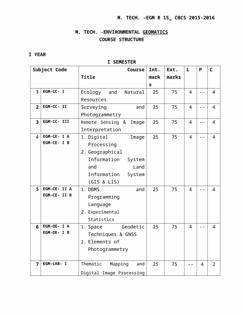
M. TECH. –EGM R 15_ CBCS 2015-2016
M. TECH. -ENVIRONMENTAL GEOMATICS COURSE STRUCTURE
I YEARI SEMESTER
Subject Code Course Title Int. marks
Ext. marks
L P C
1 EGM-CC- I Ecology and Natural Resources 25 75 4 -- 42 EGM-CC- II Surveying and Photogrammetry 25 75 4 -- 4
3 EGM-CC- III Remote Sensing & Image Interpretation
25 75 4 -- 4
4 EGM-CE- I AEGM-CE- I B
1. Digital Image Processing2. Geographical Information
System and Land Information System (GIS & LIS)
25 75 4 -- 4
5 EGM-CE- II AEGM-CE- II B
1. DBMS and Programming Language
2. Experimental Statistics
25 75 4 -- 4
6 EGM-OE- I AEGM-OE- I B
1. Space Geodetic Techniques & GNSS
2. Elements of Photogrammetry
25 75 4 -- 4
7 EGM-LAB- I Thematic Mapping and Digital
Image Processing Lab
25 75 -- 4 2
8 Seminar I 50 -- -- 4 2
Total C (6 Theory + 1 Lab+ seminar) 28

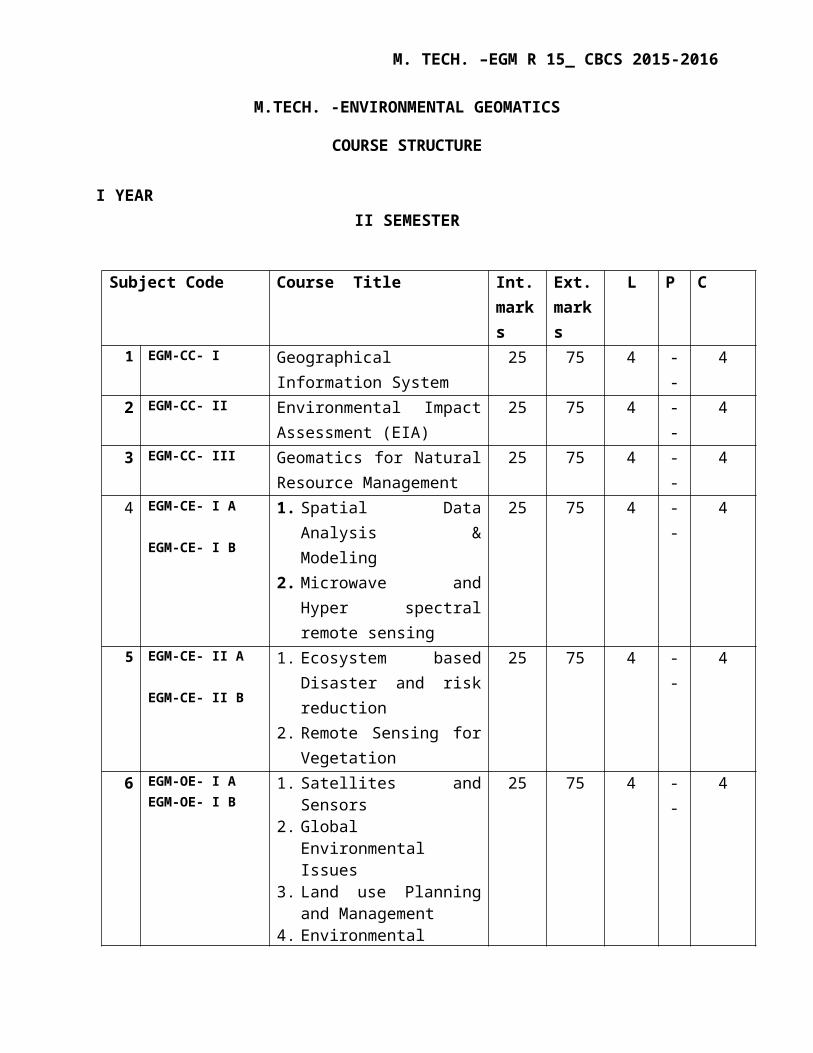
M. TECH. –EGM R 15_ CBCS 2015-2016
M.TECH. -ENVIRONMENTAL GEOMATICS
COURSE STRUCTURE
I YEARII SEMESTER
Subject Code Course Title Int. marks
Ext. marks
L P C
1 EGM-CC- I Geographical Information System
25 75 4 -- 4
2 EGM-CC- II Environmental Impact Assessment (EIA)
25 75 4 -- 4
3 EGM-CC- III Geomatics for Natural Resource Management
25 75 4 -- 4
4 EGM-CE- I A
EGM-CE- I B
1. Spatial Data Analysis & Modeling
2. Microwave and Hyper spectral remote sensing
25 75 4 -- 4
5 EGM-CE- II A
EGM-CE- II B
1. Ecosystem based Disaster and risk reduction
2. Remote Sensing for Vegetation
25 75 4 -- 4
6 EGM-OE- I AEGM-OE- I B
1. Satellites and Sensors2. Global Environmental
Issues3. Land use Planning and
Management4. Environmental Modeling &
Planning for Smart cities
25 75 4 -- 4
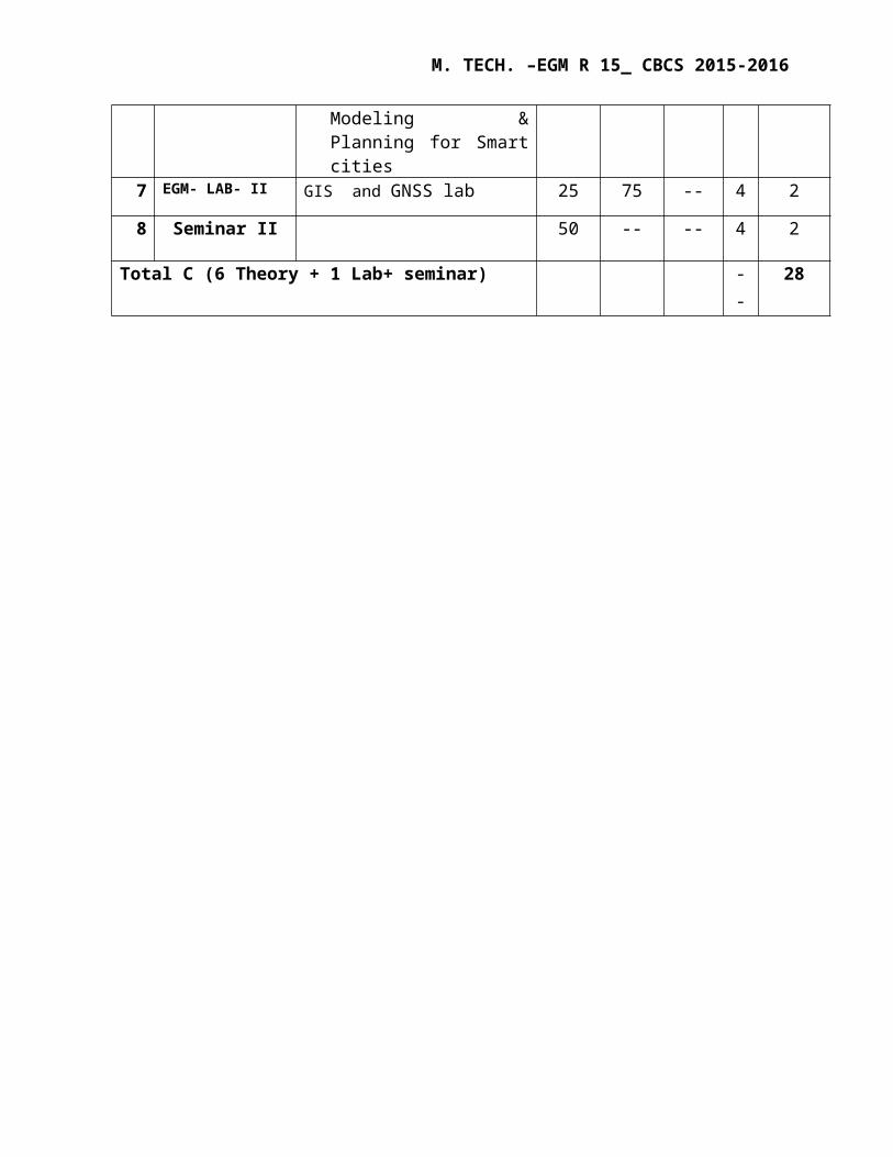
7 EGM- LAB- II GIS and GNSS lab 25 75 -- 4 2
8 Seminar II 50 -- -- 4 2
Total C (6 Theory + 1 Lab+ seminar) -- 28
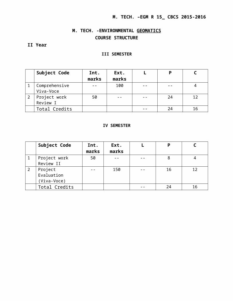
M. TECH. –EGM R 15_ CBCS 2015-2016
M. TECH. -ENVIRONMENTAL GEOMATICS COURSE STRUCTURE
II Year
III SEMESTER
Subject Code Int. marks
Ext. marks
L P C
1 Comprehensive Viva-Voce
-- 100 -- -- 4
2 Project work Review I 50 -- -- 24 12Total Credits -- 24 16
IV SEMESTER
Subject Code Int. marks
Ext. marks L P C
1 Project work Review II 50 -- -- 8 42 Project Evaluation
(Viva-Voce)-- 150 -- 16 12
Total Credits -- 24 16
M. TECH. –EGM R 15_ CBCS 2015-2016
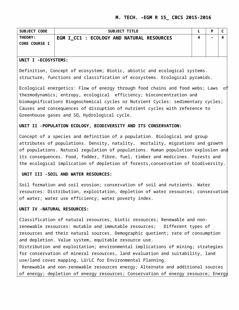
SUBJECT CODE SUBJECT TITLE L P CTHEORY: CORE COURSE I
EGM I_CC1 : ECOLOGY AND NATURAL RESOURCES 4 - 4
UNIT I -ECOSYSTEMS:
Definition, Concept of ecosystem; Biotic, abiotic and ecological systems. structure, functions and classification of ecosystems. Ecological pyramids.
Ecological energetics: Flow of energy through food chains and food webs; Laws of thermodynamics; entropy, ecological efficiency; bioconcentration and biomagnifications Biogeochemical cycles or Nutrient Cycles: sedimentary cycles; Causes and consequences of disruption of nutrient cycles with reference to Greenhouse gases and SOx.
Hydrological cycle.
UNIT II -POPULATION ECOLOGY, BIODIVERSITY AND ITS CONSERVATION:
Concept of a species and definition of a population. Biological and group attributes of populations. Density, natality, mortality, migrations and growth of populations. Natural regulation of populations. Human population explosion and its consequences. Food, fodder, fibre, fuel, timber and medicines. Forests and the ecological implication of depletion of forests,conservation of biodiversity.
UNIT III -SOIL AND WATER RESOURCES:
Soil formation and soil erosion; conservation of soil and nutrients. Water resources: Distribution, exploitation, depletion of water resources; conservation of water; water use efficiency; water poverty index.
UNIT IV -NATURAL RESOURCES:
Classification of natural resources, biotic resources; Renewable and non-renewable resources: mutable and immutable resources; Different types of resources and their natural sources. Demographic quotient; rate of consumption and depletion. Value system, equitable resource use.Distribution and exploitation; environmental implications of mining; strategies for conservation of mineral resources, land evaluation and suitability, land use/land cover mapping, LU/LC for Environmental Planning. Renewable and non-renewable resources energy; Alternate and additional sources of energy; depletion of energy resources; Conservation of energy resource; Energy use efficiency. Solar radiation and its technological ways of harvesting; Solar collectors, photovoltaic, solar ponds; Hydroelectric power, Tidal, Ocean Thermal Energy Conversion, Wind, Geothermal Energy, Nuclear energy-fission and fusion, Hydrogen & Fuel cells.UNIT V-SUSTAINABLE DEVELOPMENT:
Current concepts of conservation; sustainable development; Homeostasis; Ecological foot print; Carbon foot print; consumerism.
References:
1. Fundamentals of Ecology by EP odum, WB Saurders & Co., 5th edition.2. Environment and Natural Resources conservation by Trivedi R.K, 2002.3. Remote sensing in Geology to Seigal, John wiely 1999.
M. TECH. –EGM R 15_ CBCS 2015-2016
SUBJECT CODE SUBJECT TITLE L P CTHEORY: CORE COURSE II
EGM I_CC II : SURVEYING AND PHOTOGRAMMETRY 4 - 4
UNIT I: INTRODUCTION TO SURVEYING AND CARTOGRAPHY:Datum and Reference System, horizontal data and Vertical data: Topographical surveys, Photogrammetric surveys, Engineering surveys:- Hydrographic surveys, Mine surveys, Cadastral surveys.
UNIT II: SURVEYING AND MAPPING:Conventional mapping versus Digital mapping, list of mapping organizations, Classification of maps. Control Survey: Horizontal, vertical and both, Contour survey and Depiction of heights. Introduction to Elevation Determination, Systematic Errors in Differential Leveling, Random Errors In Differential Leveling, Error Propagation in Trigonometric Leveling
UNIT III: MODERN TRENDS IN SURVEYING AND MAPPING: Global Positioning System for ground control and extension, Total station system for detail surveying, Digital Photogrammetric Survey, Remote Sensing, Digital Cartography, Geographical Information System.
UNIT IV: BASICS OF PHOTOGRAMMETRY: History of Photogrammetry, Definition and terminology, Geometry and Types of photographs, Photographic scale, relief displacement, photographic overlaps, Types of aerial cameras, Ground control, Photo mosaics. Flight planning – Crab and drift – Computations for flight planning, Specification for Aerial Photography.
UNIT V: PHOTOGRAMMETRY AND CONSIDERATIONS: Stereo photogrammetry introduction, Parallax equations and height determination, Overview on applications of Photogrammetry.
Textbooks:1. Geo-informatics for Environmental Management by M. Anji Reddy, BS Publications, 2nd edition, 2004.2. Text book of Photogrammetry by P.R. Wolf, 2nd edition.3. Surveying and Mapping, Volume I and II by David Clarke, 1996.
References:1. Manual of Photogrammetry – American society of Photogrammetry & R.S by Albert.D, 1952.
M. TECH. –EGM R 15_ CBCS 2015-2016
SUBJECT CODE SUBJECT TITLE L P CTHEORY: CORE COURSE III
EGM I_CC III : REMOTE SENSING & IMAGE INTERPRETATION
4 - 4
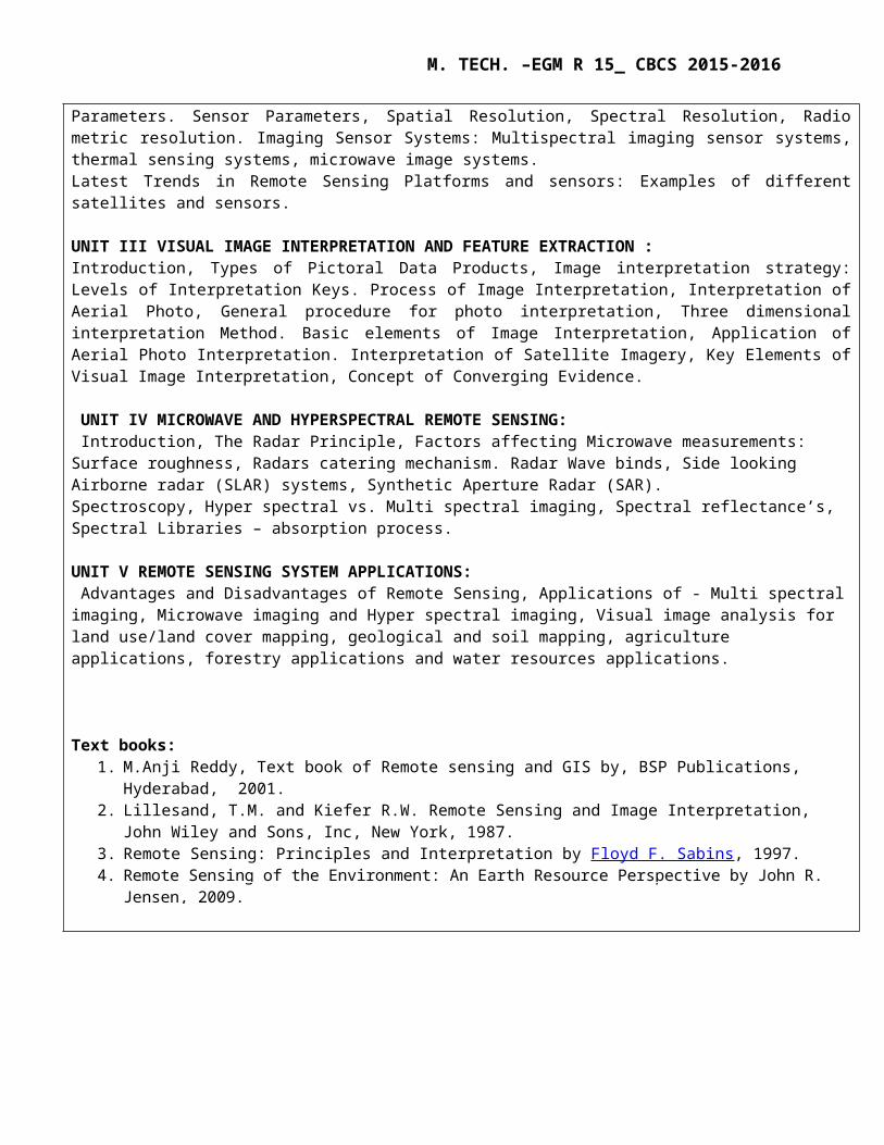
UNIT I REMOTE SENSING – BASIC PRINCIPLES:Introduction, Electromagnetic Remote Sensing Process, Physics of Radiant Energy: Nature of Electromagnetic Radiation, Electromagnetic Spectrum. Energy Source and its Characteristics, Atmospheric Interactions with Electromagnetic Radiation: Atmospheric Properties, Absorption Ozone, Atmospheric Effects on Spectral Response Patterns. Energy Interactions with Earth’s Surface Materials: Spectral Reflectance Curves. Cossine Law. UNIT II REMOTE SENSING SYSTEM AND SENSOR PARAMETERS: Introduction, Satellite System Parameters: Instrumental Parameters, Viewing Parameters. Sensor Parameters, Spatial Resolution, Spectral Resolution, Radio metric resolution. Imaging Sensor Systems: Multispectral imaging sensor systems, thermal sensing systems, microwave image systems.Latest Trends in Remote Sensing Platforms and sensors: Examples of different satellites and sensors. UNIT III VISUAL IMAGE INTERPRETATION AND FEATURE EXTRACTION :Introduction, Types of Pictoral Data Products, Image interpretation strategy: Levels of Interpretation Keys. Process of Image Interpretation, Interpretation of Aerial Photo, General procedure for photo interpretation, Three dimensional interpretation Method. Basic elements of Image Interpretation, Application of Aerial Photo Interpretation. Interpretation of Satellite Imagery, Key Elements of Visual Image Interpretation, Concept of Converging Evidence. UNIT IV MICROWAVE AND HYPERSPECTRAL REMOTE SENSING: Introduction, The Radar Principle, Factors affecting Microwave measurements: Surface roughness, Radars catering mechanism. Radar Wave binds, Side looking Airborne radar (SLAR) systems, Synthetic Aperture Radar (SAR).Spectroscopy, Hyper spectral vs. Multi spectral imaging, Spectral reflectance’s, Spectral Libraries – absorption process.
UNIT V REMOTE SENSING SYSTEM APPLICATIONS: Advantages and Disadvantages of Remote Sensing, Applications of - Multi spectral imaging, Microwave imaging and Hyper spectral imaging, Visual image analysis for land use/land cover mapping, geological and soil mapping, agriculture applications, forestry applications and water resources applications.
Text books:1. M.Anji Reddy, Text book of Remote sensing and GIS by, BSP Publications, Hyderabad, 2001.2. Lillesand, T.M. and Kiefer R.W. Remote Sensing and Image Interpretation, John Wiley and Sons, Inc, New York,
1987.3. Remote Sensing: Principles and Interpretation by Floyd F. Sabins, 1997.4. Remote Sensing of the Environment: An Earth Resource Perspective by John R. Jensen, 2009.
M. TECH. –EGM R 15_ CBCS 2015-2016
SUBJECT CODE SUBJECT TITLE L P CTHEORY: Core Elective I
EGM I_CE-1 A DIGITAL IMAGE PROCESSING 4 - 4
UNIT I: DIGITAL COMPUTERS AND IMAGE PROCESSING:Introduction: Information Systems – Encoding and decoding, modulation, Satellite data – acquisition, storage and retrieval – generation of data products digital data formats. Computer basics: Hardware and Software, Networks, Image Display Subsystem, Color Display System, Hard copy System , Data Format for Digital Satellite Imagery, Image file Format and Data Compression
UNIT II: PRE-PROCESSING OF REMOTE SENSING DATA AND IMAGE ENHANCEMENT TECHNIQUES: Cosmetic Operations- Missing Scan Lines, De –stripping Methods, Geometric Corrections and Registration. Coordinate Transformations, Atmospheric Correction Methods, Illuminations and View Angle Effects, Sensor Calibration and Terrain Effects and radiometric correction methods.Introduction to image enhancement, Human Visual Systems, Contrast Enhancement- Linear Contrast Stretch, Histogram Equalization, Guassian Stretch, Pseudo Color Enhancement- Density Slicing, Pseudo Color Transform.
UNIT III: IMAGE TRANSFORMS AND IMAGE FILTERING TECHNIQUES: Introduction, Arithmetic Operations- Image Addition, Subtraction, Multiplication and Division. Empirically Based Image Transforms- Perpendicular Vegetation Index, Tasselled Cap Transformations, NDVI. PRINCIPAL COMPONENT ANALYSIS: Standard PCA, Noise Adjusted PCA, Decorrelation Stretch, Hue -Saturation and Intensity Transform, Fourier Transform Introduction to image filtering, Low Pass Filters- Moving Average Filters, Median Filters, Adaptive Filters, High Pass Filters- Image Subtraction Method, Derivative Based Method, Frequency Domain Filters, Filtering for Edge Enhancement
UNIT IV: IMAGE CLASSIFICATION AND ACCURACY ASSESSMENT: Introduction, Geometrical Basis of Classification, Unsupervised classification, Supervised Classification Training Samples, Statistical Parameters and Classifiers, Other Approaches to Image Classification, Feature Selection, Contextual Information Image classification accuracy assessment, Performance analysis, Various Band Data for Land use, Land Cover Classification System with Case Studies.
UNIT V: IMAGE CLASSIFICATION AND GIS INTEGRATION:Image Classification and GIS, Integration and Linkage. Software: ERDAS, EASI /PACE, Geomatica and ENVI.
Text books:
1. M. Anji Reddy, Y. Harishanker - Digital Image Processing, B.S. Publications, Hyderabad, 2nd edition.2. John, R. Jensen, Introductory Digital Image Processing – Prentice Hall, New Jersey, 1986.3. Robert, A. Schowengergt. Techniques for image processing and classification in Remote Sensing, 1983.4. Hord, R.M. Digital Image Processing, Academic Press Pub. 1982.
Paul. M. Mather & Magaly Koch - Computer Processing of RS Images- An Introduction, Wiley Blackwell publication, 4th edition, 2011.

M. TECH. –EGM R 15_ CBCS 2015-2016
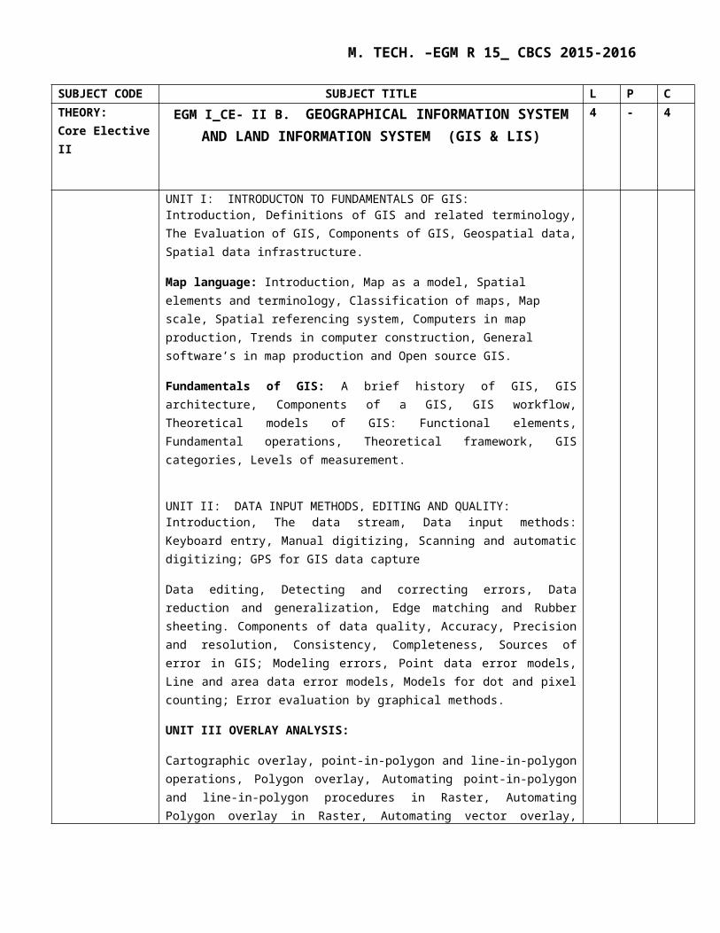
SUBJECT CODE SUBJECT TITLE L P CTHEORY: Core Elective II
EGM I_CE- II B. GEOGRAPHICAL INFORMATION SYSTEM AND LAND INFORMATION SYSTEM (GIS & LIS)
4 - 4
UNIT I: INTRODUCTON TO FUNDAMENTALS OF GIS: Introduction, Definitions of GIS and related terminology, The Evaluation of GIS, Components of GIS, Geospatial data, Spatial data infrastructure.
Map language: Introduction, Map as a model, Spatial elements and terminology, Classification of maps, Map scale, Spatial referencing system, Computers in map production, Trends in computer construction, General software’s in map production and Open source GIS.
Fundamentals of GIS: A brief history of GIS, GIS architecture, Components of a GIS, GIS workflow, Theoretical models of GIS: Functional elements, Fundamental operations, Theoretical framework, GIS categories, Levels of measurement.
UNIT II: DATA INPUT METHODS, EDITING AND QUALITY: Introduction, The data stream, Data input methods: Keyboard entry, Manual digitizing, Scanning and automatic digitizing; GPS for GIS data capture
Data editing, Detecting and correcting errors, Data reduction and generalization, Edge matching and Rubber sheeting. Components of data quality, Accuracy, Precision and resolution, Consistency, Completeness, Sources of error in GIS; Modeling errors, Point data error models, Line and area data error models, Models for dot and pixel counting; Error evaluation by graphical methods.
UNIT III OVERLAY ANALYSIS:
Cartographic overlay, point-in-polygon and line-in-polygon operations, Polygon overlay, Automating point-in-polygon and line-in-polygon procedures in Raster, Automating Polygon overlay in Raster, Automating vector overlay, types of overlay.
UNIT IV: LAND CADASTRAL INFORMATION:
Definition, Practices in India, Units in vougue; Elements of cadastral survey – graphical and textual records; National Land Records Modernization programme – Vectorization of Village Cadastral Maps, Record of Rights (RoRs), Use of Total Station, GNSS, Orthophoto, hybrid techniques; Coordinate systems – Field practices; Preparing Land Parcel Map (LPM), village map, district level database; QA / QC procedures
M. TECH. –EGM R 15_ CBCS 2015-2016
UNIT V INTEGRATED MODELING USING GIS:
Hydrological Modeling - water quality modeling, watershed management and modeling, saltwater intrusion models. Land-surface-subsurface Process Modeling - pipeline alignment studies, solid and hazardous waste disposal site selection, zoning atlas for industrial siting, environmental information system development. Ecosystem modeling, risk and hazard modeling.
Textbooks:
1. Manual of Geospatial Science and Technology Edited By John. D. Bossler, Taylor And Francis, London
2. Geographical Information Systems by Demers3. Geo-informatics for Environmental Management by M. Anji Reddy,
BS Publications, 2nd edition, 2004.

M. TECH. –EGM R 15_ CBCS 2015-2016
SUBJECT CODE SUBJECT TITLE L P CTHEORY: Core Elective II
EGM I_CE-II A : DBMS AND PROGRAMMING LANGUAGE 4 - 4
UNIT I: INTRODUCTION:General:-Database System Applications- Purpose of Database System, View of Data, Database Languages, Relational Database, Database design, Data storage and querying, Transaction management, Database Architecture, Data mining and information retrieval, Database Users- Data-Administrators and History of Database systems. UNIT II: RELATIONAL DATABASES:Structure of Relational Databases, Database Schema, keys, Schema diagrams, Relational query languages and relational operations.SQL: SQL data definition, Basic Structure of SQL queries, Set Operations, Aggregate Functions, Null Values, Nested Sub queries, Modification of the Database.Intermediate SQL: Join expressions, views, transactions, integrity constraints, SQL data types and schemas and authorization.
UNIT III: DATABASE DESIGN and DATABASE STORAGE:Overview of the design process, the entity- relationship model, ER- diagrams, features of good relational design, database design process.Storage & File Structure: Overview of Physical Storage Media- Magnetic Disks- Flash Storage RAID, tertiary storage, File Organization- Organization of records in Files- Data-Dictionary storage, database buffer.Indexing & Hashing: Basic Concepts- Ordered Indices- B+ -Tree Index Files- B+ -Tree extensions- Static Hashing- Dynamic Hashing, bitmap indices and index definition in SQL.
UNIT IV: INTRODUCTION TO DOT NET PLATFORM AND LANGUAGE FEATURES:Understanding the .Net platform and its layers, components of .Net platform and its functions, structure of a .Net application.Language fundamantals in C#, Control statements.Language fundamantals in VB.NET, Features and Control statements.
UNIT V: OBJECT ORIENTED PROGRAMMING CONCEPTS:Concepts of procedural programming, object oriented programming, classes, encapsulation, inheritance, polymorphism, understanding Csharp and VB.NET as object oriented programming languages.
Reference Books:1. Database System Concepts by Silberschatz- McGraw Hill Editon.2. Database Management Systems by Gerald V Post- Tata Mc-Graw Hill edition.3. Database Management Systems by Ramakrishnan- Tata Mc-Graw Hill edition.4. .NET tutorial for Beginners by Microsoft professionals.

M. TECH. –EGM R 15_ CBCS 2015-2016
SUBJECT CODE SUBJECT TITLE L P C
THEORY: Core Elective II
EGM I_CE-II B : EXPERIMENTAL STATISTICS 4 - 4
UNIT I: INTRODUCTION AND FREQUENCY DISTRIBUTION:Types of proof, Generality of Applications of statistics, Examples of statistical problemsRaw data, Arrays, Frequency Distributions, Class interval and Class limits ,Class boundaries, Size ,width of a class interval ,class mark, general rules for forming frequency distributions, Histograms and frequency polygons, relative frequency distributions, cumulative frequency distributions and 0gives, Relative cumulative-frequency distribution and percentage 0gives, frequency curves and smoothed 0gives,types of frequency curves
UNIT II: MEASUREMENTS AND THEIR ANALYSIS:Introduction, Sample Versus Population, Range and Median, Graphical Representation of Data, Numerical Methods of Describing Data, Measures of Central Tendency, Standard deviation and other measures of Dispersion.
UNIT III: RANDOM ERROR THEORY AND CONFIDENCE INTERVAL: Introduction, Theory of Probability, Properties of the Normal Distribution Function, Probability of the Standard Error, Uses of Percent Errors, Moments, Skewness and KurtosisIntroduction, Distributions used in Sampling Theory, Confidence Interval for the Mean, Sampling, its uses, some sampling distributions, Analysis of Variance
UNIT IV: CORRELATION AND REGRESSION:Curve fitting and the method of Least squares, Correlation theory, Multiple and partial correlations, Linear regression, Multiple regression, R2, regression modeling.
UNIT V: STATISTICAL TESTING AND STATISTICAL ANALYSIS :Tests of significance, Chi-square and F-test, Non parametric tests, t-tests.
Analysis of Time series, Statistical Process control and Process capability
Books:
1. Theory and Problems of STATISTICS by Murray R. Spiegel and Larry J. Stephens2. Basics Statistics by B.L.Agarwal3. Introduction to statistical Analysis by Wilfred J. Dixon and Frank J. Massey JR
M. TECH. –EGM R 15_ CBCS 2015-2016
SUBJECT CODE SUBJECT TITLE L P CTHEORY: Open Elective I
EGM I_OE-1A : SPACE GEODETIC TECHNIQUES & GNSS
4 - 4
UNIT I: INTRODUCTION: Definition of Geodesy- problems of Geodesy- Ellipsoid of Revolution- coordinate system of Rotational Ellipsoid and spatial Ellipsoid- computations on the Ellipsoid- Gravity- Satellite Geodesy, reference surface, Geoid models- Indian datum- World Geodetic System.
UNIT II: GLOBAL NAVIGATION SATELLITE SYSTEM ( GNSS):Global Positioning System (GPS), Description of the System and their orbits, GPS measurement strategies; Advantages and limitations of GPS, reference frames and other space geodetic techniques (satellite & lunar laser ranging, VLBI, Doppler orbitography, GLONASS, GALILEO).
UNIT III: GPS SIGNAL STRUCTURE:Carriers, GPS codes: C/A, P, navigational message, GPS receiver: Types and Structure of receivers, Principles of GPS position fixing: Pseudo ranging. Determination of GPS satellite coordinates, Types of ephemerides, Data Pre-processing, GPS data formats.
UNIT IV: DIFFERENTIAL GPS:Principles of DGPS, Real Time Kinematics, Various modes and applications of DGPS, Enhancement of Accuracy.
UNIT V: APPLICATIONS:Geodetic control surveys, Cadastral surveys, Photogrammetry, Remote sensing, Engineering and monitoring. Military applications, Geographical Information System, Vehicle tracking and car navigation, LBS and special applications.
Reference Books: 1. Linear Algebra, Geodesy and GPS, Gilbert strang Kai Borre, Wellesley- Cambridge press, 1997. 2. Satellite Geodesy by Gunter Seeber, 1st eition, Walter de gruzter Gmbtl & co.KG, 10785 Berlin, 1993.3. Essentials of GPS by N.K. Agrawal, spatial network Pvt.Ltd. Hyderabad, 2004.4. Geo-informatics for Environmental Management by M. Anji Reddy, BS Publications, 2nd edition, 2004.
M. TECH. –EGM R 15_ CBCS 2015-2016
SUBJECT CODE SUBJECT TITLE L P CTHEORY: Open Elective I
EGM_OE-1B : ELEMENTS OF PHOTOGRAMMETRY 4 - 4
UNIT I: INTRODUCTION TO DPW SYSTEMS: Definition of Digital Photogrammetry & Its Development, Digital Photogrammetry Vis-À-Vis Analogue Photogrammetry, Advantages of Digital Photogrammetry, Hardware & Software Components of DPWS, Various Inputs For Digital Photogrammetry: Scanned Photo, Digital Camera Data, Remote Sensing Data, Lidar Data, Video Camera Data, Basic Consideration of Photogrammetric Scanners: Principle of Image Scanning, Configuration of Scanners, Method of Scanning, File Format and Size.
UNIT II: STEREO PHOTOGRAMMETRY: Stereoscopic depth perception – different types of stereoscopes vertical exaggeration – base lining and orientation – principle of floating mark, Photographic co-ordinate systems, Measurement and refinement of image co-ordinates – Methods of parallax measurement, derivation of parallax equations, Elevations by parallax differences, Measurement of parallax differences, computing flying height and airbase, Interior orientation, Empirical and numerical relative orientation, absolute orientation, model deformation. Derivation of the collinearity and coplanarity equations and their applications.
UNIT III: IMAGE MEASUREMENTS & THEIR REFINEMENT: Introduction to Coordinate Systems And Image Measurements, Simple Scales For Photographic Measurements, Measuring Photo Coordinates With Simple Scales, Trilaterative Method of Photo Coordinate Measurement, Measurement of Photo Coordinates With Tablet Digitizers, Mono Comparator Measurement of Photo Coordinates. Refinement of Measured Image Coordinates: Distortions of Photographic Films and Paper, Shrinkage Correction, Lens Distortions Corrections, Atmospheric Refraction Correction, Earth Curvature Correction, Reduction of Coordinates to an Origin at the Principal Point.
UNIT IV: ORIENTATION PROCEDURES IN DIGITAL PHOTOGRAMMETRY:Inner orientation(IO),Transformation & Its Suitability, Exterior Orientation (EO),Auto Tie Point Generation, Digital Image Matching Process: Area Based, Feature and Relation Based, Collinearity Conditions, Block Triangulation Method and Adjustment, Simultaneous Solution for unknowns in a Block, Space Resection Method, Space Forward Intersection. Use of GPS and IMU in Digital Photogrammetry
UNIT V: 3D VISUALIZATION & STEREO-COMPILATION: Principle and Method of 3d Visualization: Anaglyph, Polarized and Hybrid Techniques, Feature Extraction, Feature Coding, Data Model and Feature Class. Definition DEM, DTM, DSM, Various Inputs to DEM/DTM, DTM Specification And Accuracy , Application of DTM, Various Interpolation Techniques: Grid, TIN, Break Lines, Mass Points, Digital Ortho-Photo Generation and its uses.
Text Books: 1.Elements of Photogrammetry- Paul r. wolf, 2nd edition, 1983.2.Elements of Photogrammetry with application in GIS (3rd edition)- Paul Wolf & Bon Dewitt, 3.Benjamin Wilkinson, McGraw-Hill companies, incorporated, 2013, 4th edition.Reference: -1.Manual of Photogrammetry – American society of Photogrammetry & R.S by Albert.D, 1952.2.Digital Photogrammetry – A practical course by Wilfried Linder, 3rd edition, Springer, 2009.3.Digital Photogrammetry by – Y. Egels & Michel Kasser, Taylor & Francis group, 2002.4.Geographic information systems an introduction by – Tor Bernhardsen, 3rd edition, John Wiley & Sons, Newyork, 2009.
M. TECH. –EGM R 15_ CBCS 2015-2016
SUBJECT CODE
SUBJECT TITLE L P C
Laboratory I EGML1 : THEMATIC MAPPING AND DIGITAL IMAGE PROCESSING LAB
4 - 2
Thematic mapping: Study of Toposheet Base map preparation Road network Drainage Watershed Slope Land use/land cover Geomorphology
Digital Image Processing (on ERDAS, Arc GIS and ENVI): Loading of digital data and extraction of study area Geometric Correction Image rectification Filtering Techniques Image classification - Supervised and Unsupervised Classification Map Composition and Output Generation

M. TECH. –EGM R 15_ CBCS 2015-2016
M. Tech EGM- II SEMESTER

M. TECH. –EGM R 15_ CBCS 2015-2016
SUBJECT CODE
SUBJECT TITLE L P C
Theory
Core Course I
EGM II_CC I: GEOGRAPHICAL INFORMATION SYSTEMS
4 - 4
UNIT I: FUNDAMENTALS OF GIS:
Map – scale, projection and symbolism. GIS - Introduction, definition and terminology, categories, components, fundamental operations, functional elements. Data structures, data models, GIS data, acquisition, input, storage, output generation. Data preprocessing, database management, integrated analysis of spatial and attribute data.
UNIT II: GIS SPATIAL ANALYSIS , MEASUREMENT AND SPATIAL ARRANGEMENT:
Introduction, Defining spatial objects - point, line and area objects based on their attributes, higher level point, line and area objects. Measuring length of linear objects, measuring polygons, measuring shape, measuring distance. Classification – Principles, Neighborhood functions, Polygonal neighborhoods, Buffers. Spatial Arrangement - Point patterns, Theissen Polygons, Area patterns, Linear patterns, Directionality of Linear and Areal objects, Connectivity of Linear objects, Routing and allocation.
UNIT III: STATISTICAL SURFACES AND OVERLAY ANALYSIS:
Surface mapping, sampling the statistical surface, Digital Elevation Model (DEM). Interpolation- linear and non-linear, uses and problems. Terrain reclassification – steepness of slope, aspect, shape or form. Discrete surfaces - dot distribution maps, choropleth maps. Cartographic overlay, point-in-polygon and line-in-polygon operations, Polygon overlay, Automating point-in-polygon and line-in-polygon procedures in Raster, Automating Polygon overlay in Raster, Automating vector overlay, types of overlay.
UNIT IV: DATA MODELING:
The state of GIS for Environmental Problem Solving, A Perspective on the State of Environmental Simulation Modeling, GIS and Environmental Modeling, The Role of Software Venders in Integrating GIS and Environmental Modeling, Cartographic Modeling, Scope of GIS and relationship to environmental modeling, data models and data quality.
UNIT V: INTEGRATED MODELING USING GIS:
Hydrological Modeling - water quality modeling, watershed management and modeling, saltwater intrusion models. Land-surface-subsurface Process Modeling - pipeline alignment studies, solid and hazardous waste disposal site selection, zoning atlas for industrial siting, environmental information system development. Ecosystem modeling, risk and hazard modeling.
Text Books:
1. M.Anji Reddy, Text book of Remote sensing and GIS by, BSP Publications, Hyderabad, fourth edition..2. Fundamentals of Geographic Information Systems by Michael N DeMers. Published By john Wiley & Sons Inc.,
3rd edition, 2008.3. Environmental Modeling with GIS, Michael F. Autor Goodchild, Bradley O. Parks, Louis T. Stewart, publisher-
Oxford university press, 1993.4. Geographic Information Systems: A Management Perspective by Stan Arnoff, WDL publications, 1989.

M. TECH. –EGM R 15_ CBCS 2015-2016
SUBJECT : CODE SUBJECT TITLE L P CTheoryCORE COURSE -II
EGM II_CC II : ENVIRONMENTAL IMPACT ASSESSMENT (EIA)
4 - 4
UNIT I: CONCEPTUAL FACTS OF EIA: Introduction, Definition and Scope of EIA, Objectives in EIA, Basic EIA Principles, Classification of EIA: Strategic EIA (SEIA), Regional EIA, Sectoral EIA, Project Level EIA and Life Cycle Assessment, Project Cycle, Grouping of Environmental Impacts: Direct Impacts, Indirect Impacts, Cumulative Impacts and Induced Impacts. Significance of Impacts: Criteria/Methodology to Determine the Significance of the Identified Impacts.
UNIT II: BASELINE DATA ACQUISITION, PLANNING AND MANAGEMENT OF IMPACT STUDIES: Environmental Inventory, Data Products and Sources: thematic data, topographical data, collateral data and field data. Environmental Baseline Monitoring (EBM), Preliminary Study to determine impact significance, Environmental Monitoring network Design, Monitoring Stations, Air quality data acquisition, Water Quality data acquisition, soil data, socioeconomic data and biological data acquisition. Impact on Environmental Components: Significance of Impacts, Criteria to determine the significance of the identified Impacts.Conceptual Approach for Environmental Impact Studies, Proposal Development, Interdisciplinary Team Formations, Team Leader Selection and Duties, General Study Management, Fiscal Control
UNIT III: OPERATIONAL ASPECTS OF EIA AND METHODS FOR IMPACT IDENTIFICATION: Screening: Application for Prior Screening for Environmental Clearance, Screening Criteria; Category A Projects, Category B Projects, Criteria for Classification of Category B1 and B2 Projects, Consistency with other Requirements and Siting Guidelines. Scoping: Identification of Appropriate Valued Environmental Components (VEC), Identification of Impacts, Information in Form 1, Structure of a Pre-feasibility Report. Public consultation: Appraisal, Decision Making, Post-clearance Monitoring Protocol.Background Information, Interaction-Matrix Methodologies: simple matrices, stepped matrices, development of a simple matrix, other types of matrices, summary observations on matrices, Network Methodologies: Checklist methodologies, simple checklists, descriptive Checklists, summary observations on simple and descriptive Checklists.
UNIT IV: PREDICTION OF IMPACTS (AIR-WATER- NOISE- BIOLOGICAL AND SOCIO-ECONOMIC): a) Air Environment: Basic information on air quality, Sources of Pollutants, effects of pollutions, Conceptual approach for addressing air environment impacts, Air quality standards, Impact Prediction, Impact significance. b) Water Environment: Basic Information on surface-Water Quantity and Quality, Conceptual Approach for Addressing Surface-Water-Environment Impacts, Identification of Surface-Water Quantity or Quality Impacts, Procurement of Relevant Surface-Water Quantity-Quality Standards, Impact Predictions, Assessment of Impact Significance. c) Noise Environment: Basic Information on Noise Key Federal Legislation and Guidelines, Conceptual Approach for Addressing Noise-Environment Impacts, Identification of Noise Impacts, Procurement of Relevant Noise Standards and/or Guidelines, Impact Prediction, Assessment of Impact Significance.
M. TECH. –EGM R 15_ CBCS 2015-2016
d) Biological Environment: Basic Information on Biological Systems, Conceptual Approach for Addressing Biological Impacts, Identification of Biological Impacts, Description of Existing Biological Environment Conditions. e) Socio-Economic Environment: Procurement of Relevant Legislation and Regulations, Impact Prediction, Assessment of Impact Significance.
UNIT V: ENVIRONMENTAL MANAGEMENT PLAN (EMP): Case Study, identification of Impacts, EMP for Air Environment: Dust Control Plan, Procedural Changes, Diesel Generator Set Emission Control Measures, Vehicle Emission Controls and Alternatives, Greenbelt Development. EMP for Noise Environment, EMP for Water Environment: Water Source Development, Minimizing Water Consumption, Domestic and Commercial Usage, Horticulture, Storm Water Management. EMP for land Environment: Construction Debris, hazardous Waste, Waste from temporary Labour settlements.
Text Books: 1. Textbook of Environmental Science & Technology by M.Anji Reddy, BS Publications, 20102. Technological guidance manuals of EIA. MoEF.3. Environmental Impact Assessment by Harry W. Canter, McGraw Hill, 1996, 2nd edition.4. Man and Environment D.H.Carson 1976 Interactions Part I and III.5. Environmental Impact Assessment, 2003, Y.Anjaneyulu, B.S Publications6. Erickson, P.A.1979 Environmental Impact Assessment Principles and applications7. Basic Concepts in Remote Sensing & Arial Photogrammetry Lillesand & Keifer Printice Hall Intl.,
1994.8. Renewable Energy: environment and development, Maheswar Dayal, Konark Publishers, 1989.

M. TECH. –EGM R 15_ CBCS 2015-2016
SUBJECT CODE
SUBJECT TITLE L P C
Theory:Core Course III
EGM II_CC III : GEOMATICS FOR NATURAL RESOURCE MANAGEMENT
4 - 4
UNIT I: LAND RESOURCES AND MUNICIPAL & URBAN GIS:Appropriate methodology, Rapid land use assessment, Rapid land use information system. Land evaluation and suitability studies by Remote sensing and . Techniques of land use / land cover map preparation. Land use / land cover mapping and planning. Dynamic urban land use, Semi dynamic land use.GST for Urban Environmental Monitoring. GST for Municipal Administration. Geomatics in Solid and Hazardous waste disposal site selection, Environmental Information System Development for municipalities: Case studies GST for Traffic and Transportation planning assessment UNIT II: GEOSCIENCES : Role of Remote sensing and GIS in geological studies and case studies. Evaluation of Geological Mapping, Introduction to Prospection Techniques, History of Remote Sensing in Geological Exploration. Image Lineaments and structural origin, Prospecting, Applications of thermal and Radar remote sensing in structural geology. Spectral response of Minerals, Rocks, Alterites, case studies UNIT III: WATER RESOURCES, GRICULTURE AND FORESTRY:The hydrological cycle, Hillslope hydrology, The drainage basin, Channel networks, Automatic derivation of catchment characteristics, The global cycle.Ground water exploration and targeting. Introduction, Characteristics, Watershed and people, Watershed characteristics, watershed management and Integrated approach for sustainable planning. Water quality modeling. Watershed Management in India, Case studies.Soil and altitude, Soil and aspect, Soil and slopes, Soil landscapes, Soil erosion modeling.Crop type classification, area estimates, and spectral response of different crops. Crop diseases and Assessment, Crop and Water management and monitoring. Advances in Crop monitoring.Survey and mapping of forest cover, Forest change detection, Forest damage assessment and Forests monitoring, Land evaluation for forestry. UNIT IV: ECOSYSTEM MODELING: Spectral response of vegetation and mapping, Ecosystem Analysis, Environmental impact analysis and monitoring, Ecosystem modeling, Wetland mapping. Spatial Models of Ecological Systems and Process. UNIT V: DISASTER MANAGEMENT:Introduction and Overview- Natural and man made hazards – Vulnerability assessment and Mapping on Disasters- Spatial Information for natural Hazard and risk assessment -Land slides- volcanoes- floods and famines- earth quakes- Drought hazard and risk assessment-Human Induced disasters- industrial disasters-

M. TECH. –EGM R 15_ CBCS 2015-2016
dams- constructional and others. Books:
1. Good child : Environmental Modeling With GIS2. Manual of Geospatial Science and Technology Edited By John. D. Bossler, Taylor And Francis,
London3. Lillesand, T.M. and Kiefer R.W. Remote Sensing and Image Interpretation, John Wiley and Sons, Inc,
New York, 1987.4. Geographical Information Systems by David Martin5. RS in Geology by Siegal6. RS in Forest Resources by John. A. Howard, Chapman and Hall.
M. TECH. –EGM R 15_ CBCS 2015-2016
SUBJECT CODE
SUBJECT TITLE L P C
Theory:Core Elective I
EGM II_CE IA : SPATIAL DATA ANALYSIS & Modeling
4 - 4
UNIT I: VECTOR DATA ANALYSIS AND RASTER DATA ANALYSIS:Buffering, Overlay, Distance Measurement, Pattern Analysis, Map Manipulation.Data Analysis Environment, Local Operations, Neighborhood Operations, Zonal Operations, Physical Distance Measure Operations, Other Raster Data Operations , Comparison of Vector- and Raster-Based Data Analysis . UNIT II: TERRAIN MAPPING AND ANALYSIS, VIEWSHEDS AND WATERSHEDS: Data for Terrain Mapping and Analysis, terrain Mapping, slope and Aspect, Surface, Curvature, Raster Versus TIN.View shed Analysis, Parameters of View shed Analysis, Application of View shed Analysis, Watershed Analysis, Factors Influencing Watershed Analysis, Applications of Watershed Analysis UNIT III: SPATIAL INTERPOLATION, GEOCODING AND DYNAMIC SEGMENTATION:Elements of Spatial Interpolation, Global Methods, Local Methods, Kriging , Comparison of Spatial Interpolation.Geocoding, Application of Geocoding, Dynamic Segmentation, Application of Dynamic Segmentation. UNIT IV: PATH ANALYSIS AND NETWORK APPLICATIONS:Path Analysis, Application of path Analysis, Network, Putting Together a Network, Network Application. UNIT V: GIS MODELS AND MODELING:Basic Elements of GIS Modeling, Binary Models, Index Models, Regression, Models, Process Models. Text Books:
1. Fundamentals of GIS by MICHAEL N DEMERS. Published By john Wiley & Sons Inc.2. Environmental Modelling with GIS, Michael F. Goodchild, Bradley O. Parks, Louis T. Steyaert3. Introduction to Geographic Information Systems By Kang-Tsung Chang (TATA McGRAW-HILL
EDITION).4. Ormsby T.E.Napoleon,R.Burke,C.groessl,L.Feaster 2004.Getting to know Arc GIS Desktop,ESRI
Press2. Burke R.T.Tilton,A.Arana 2003 Getting to Know ArcObjects.ESRI Press

M. TECH. –EGM R 15_ CBCS 2015-2016
SUBJECT CODE
SUBJECT TITLE L P C
TheoryCore Elective 1
EGM II_CE IB : MICROWAVE AND HYPER SPECTRAL REMOTE SENSING
4 - 4
UNIT I: INTRODUCTION TO MICROWAVE REMOTE SENSING: Definition, Radiometric Quantities, Radar System Components, Source of Radiation, Radar Wave Bands, RADAR Equation, Factors Affecting Microwave Measurement, Beam Polarization And Look Angle.
UNIT II: SLAR, CHARACTERISTICS AND INTERPRETATION OF SLAR IMAGERY: Definition, Radar working principle, range resolution, azimuth resolution, swath width resolution and SAR systems.Slant range scale distortion, ground range geometry, image displacement due to relief, layover, fore shorting, shadow and speckle.Geometric characteristics, Electrical characteristics, Effects of polarization, Soil response, Vegetation response, urban area response.
UNIT III: MICROWAVE SENSORS AND SATELLITES: passive microwave radiometers SEASAT, SIR, ALMAZ, ERS, ENVISAT, JERS, ALOS, RADARSAT and Applications of microwave remote sensing.
UNIT IV: HYPER SPECTRAL REMOTE SENSING: Hyper spectral imaging, imaging spectrometers, principles of spectroscopy, hyper spectral vs multi spectral imaging. spectral reflectance’s, spectral libraries, absorption process, analysis of spectral curve.
UNIT V: SATELLITES AND APPLICATIONS: Hyper spectral satellite systems viz., AVIRIS, HYMAP, HYPERION and Applications of Hyper Spectral Remote Sensing in the field of Environmental management.
TEXT BOOKS:
1. Textbook of Remote Sensing and Geographical Information Systems M.Anji Reddy, BS Publication, 3rd edition, 2008.2. Remote sensing and Image interpretation by Thomas Lilliesand and Ralphw. Keifer Published by John Wiley &Sons.6th edition, 2007. 3. Remote sensing-Principles and interpretation by Floyd F Sabins.Jr. Published by Freeman & Co., New York, 3rd edition, 2003.

M. TECH. –EGM R 15_ CBCS 2015-2016
SUBJECT CODE
SUBJECT TITLE L P C
TheoryCore Elective II
EGM II_CE IIA : ECOSYSTEM BASED DISASTER RISK REDUCTION
4 - 4
Unit I: Understanding Ecosystem and disaster phenomenaConcept and definitions and functions of different terms of disaster and Ecosystem, Approaches to understand disaster phenomena (natural science, applied science, progressive and holistic approaches),Parameters of Disaster Risk, Levels of disaster as per national guideline.
Unit II: Overview, classification, characteristics, problem areas of disastersDisaster trends (Global, national and regional),Selected models for understanding the causes of disaster and disaster risk mitigation, Classification of hazards (natural and manmade),Response time, frequency, forewarning, exposure time of different hazards, General characteristics and problem areas of different natural and man-made hazards (e.g. flood, erosion, earthquake, landslide, lightning, tropical cyclone, drought, civil unrest etc.),Common approaches to study natural and manmade hazards; vulnerability and disasters.
Unit III: Disaster risk mitigationDisaster risk assessment (Hazard-Vulnerability-Capacity analysis), Hazard mapping and forecasting; Principles and aspects of Disaster prevention, Disaster mitigation, Preparedness for damage mitigation and coping with disasters; Capacity building for disaster/damage mitigation (structural and non-structural measures); Contingency planning for damage mitigation of different hazards; Relevance of indigenous knowledge, appropriate technology and local resources in disaster risk mitigation; Community based disaster risk reduction mechanism; Counter disaster resources and their roles.
Unit IV: Environment and disastersEnvironment, ecosystem and disasters. Climate change – issues and concerns. Biodiversity loss and DRR; Global water crisis and DRR; Desertification, soil erosion and DRR; ecosystems for urban risk reduction; Industrial hazards and safety measures; Post disaster impact on environment; Impact of developmental projects on disaster risk; Aspects of environmental management for disaster risk reduction; Environmental Impact Assessment (EIA).
Unit V: Planning for disaster managementConcept of spatial planning for DRR; Community-hazard profile in India; Different phases of Disaster Management (DM cycle; Relief mechanism (needs assessment, relief administration and distribution, management of relief centres, external support etc.);Disaster Management Act (2005); Disaster Management Policy (2009); organizational framework for disaster management in India.Case studies: Hazard mapping of vulnerable areas, Vulnerability assessment (physical, social, organizational, economical, technological), Risk mitigation planning for vulnerable areas.
Text books
M. TECH. –EGM R 15_ CBCS 2015-2016
1. Alexander, D. Natural Disasters, ULC press Ltd, London, 1993.
2. Carter, W. N. Disaster Management: A Disaster Management Handbook, Asian Development Bank, Bangkok, 1991.
3. Disaster Management in India, Ministry of Home Affairs, Government of India, New Delhi, 2011.
4. National Policy on Disaster Management, NDMA, New Delhi, 2009.
5. Disaster Management Act. (2005), Ministry of Home Affairs, Government of India, New Delhi, 2005.6. Parasuraman, S & Unnikrishnan, P. V. (ed.), India Disasters Repot Towards a policy initiative. Oxford,
2000.

M. TECH. –EGM R 15_ CBCS 2015-2016
SUBJECT CODE
SUBJECT TITLE L P C
THEORY:Core Elective II
EGM-CE-I1B: REMOTE SENSING FOR VEGETATION
4 - 4
UNIT I
Introduction , History , introduction and and interpretation of Remote sensing , Concepts of Plant Physiology
and Remote Sensing. Data availability.
UNIT II : BASICS OF RADIATION PHYSICS FOR REMOTE SENSING OF VEGETATION
Introduction, Radiation characteristics, Electromagnetic Radiation, Electromagnetic Spectrum,
Electromagnetic Energy , Sources and terminology. Energy Interactions with matter and surfaces. The
radiation Environment. LAI.
UNIT III : Radiative properties of Vegetation, Soils and Water
Optical region: Leaf radiative properties, radiative properties of soil and water, radiative properties canopies.
Thermal region: Emissivity of canopy components, and canopies. Microwave region: Microwave emissivity ,
back scatter, and advantages. Plant and Canopy Function: water relations ,evaporations and water loss.
UNIT IV: Spectral Information for Sensing Vegetation
Estimation of Vegetation Cove: Spectral Indices -Vegetation indices and vegetation descriptors. Microwave
vegetation indices- estimation of vegetation using Lidar.
UNIT V : INTEGRATED APPLICATIONS
Detection and diagnosis of plant stress. Precision agriculture and crop management , Ecosystems and Forestry
Management.
1. Lillesand, T.M. and Kiefer R.W. Remote Sensing and Image Interpretation, John Wiley and Sons, Inc, New York, 1987.
2. Principles of Geographic Information Systems by John Jensen and Ryan 3. Remote Sensing: Principles and Applications - Kindle edition by Floyd F. Sabins.

M. TECH. –EGM R 15_ CBCS 2015-2016
SUBJECT CODE
SUBJECT TITLE L P C
Theory
Open Elective I
EGM II_OE IA : Satellite and Sensors 4 - 4
UNIT I: INTRODUCTION : An Overview of Remote Sensing from Space, Introduction to Electromagnetic Radiation, Basic Characteristics of Satellite Remote Sensing Systems - Satellite orbits- sensor attributes and observational characteristics, observational categories and corresponding Sensor.Ocean Remote Sensing Systems-- Visible – Near Infrared Ocean Color- Thermal Infrared, Passive Microwave Radiometers, Scatterometers, Altimeters, Synthetic Aperture Radar, UNIT II: SATELLITE ORBITS AND MISSIONS :Satellite orbits, classification of satellites, Types of satellites, satellite system infrastructure, History of Satellites, Satellite launch vehicle fleet, Indian Satellite missions namely-PSLV-C28, GSAT-16, PSLV-C27/IRNSS-1D, Mars Orbiter Mission and LVM3-X (CARE).
UNIT III: SENSORS AND PLATFORMS :Introduction, satellite system parameters- instrumental and Viewing, Sensors- Active and passive, classification, sensor parameters- spatial, spectral and radiometric resolutions, Platforms- Airborne and Space borne, constraints of satellite geometry, effects of the local environment, common orbits and details of elevation angle and ground area, types of Scanners. UNIT IV: SATELLITE PROGRAM’S:INSAT series, IRS series, RADAR imaging satellites, other satellites, GAGAN & IRNSS satellite navigation system, Extra terrestrial exploration- chandrayaan-1 and 2 & Mangalayaan, International cooperation of ISRO, future projects of ISRO. UNIT V: APPLICATIONS :Telecommunication, Resource management, Military, Academic, Telemedicine, Biodiversity Information System, Cartography, Navigation, Ocean / Marine studies and other applications.
Text books:1. M.Anji Reddy, Text book of Remote sensing and GIS by, BSP Publications, Hyderabad, 2001.2. Principles of Remote sensing, An introductory Text book by the international institute for Geo-Information sciences
and Earth Observation (ITC). 3. Satellite Technology: Principles and Applications, 2nd Edition, Anil K. Maini, Varsha Agrawal, ISBN: 978-1-119-
95727-0694 pages, June 2011.

M. TECH. –EGM R 15_ CBCS 2015-2016
SUBJECT CODE
SUBJECT TITLE L P C
TheoryOpen Elective I
EGM II_OE IB : Global Environmental Issues 4 - 4
UNIT I INTRODUCTION: Human environmental Interactions- Global Environmental Agreements & Movements - Stockholm and Beyond – Evolution of International Environmental Laws- making international , national environmental agreements.
UNIT II ENVIRONMENTAL MOVEMENTS:
Global and national movements of Significance impact: RAMSAR Convention- Green Belt movement- Green Peace – Chipko movement- Narmada Bachao Andolan – Silent valley- Doon valley and related issues / case studies
UNIT III CLIMATE CHANGE:Sea level Change – primary and secondary impacts- Adapting to Sea level changes. Global Warming- Fossil fuels- Green house gases- Global and national scenario. National Action Plan on Climate Change. (NAPCC). Climate Change and Biodiversity loss.
UNIT IV ENERGY CRISIS:Energy requirements- Developed- Developing- Under Developed nations. Cases studies of International and National importance.
UNIT V LAND DEGRADATION :
Land pollution • Desertification - Soil — Soil conservation • Soil erosion • Soil contamination • Soil salination. Mining- reclamation of mined area. Desertification-case studies
UNIT VI NUCLEAR ISSUES:
Nuclear issues —Nuclear power • Nuclear weapons • Nuclear and radiation accidents • Nuclear safety • High-level radioactive waste management.
UNIT VII NATURAL DISASTERS AND ANTHROPOGENIC:
Natural Disaster : Volcanoes- Landslides- Tsunami- Forest Fires – Case studies .Anthropogenic : Oil spills
UNIT VIII CONTEMPORARY ISSUES:
Green Buildings- Genetic pollution- Genetically modified food controversies. Intensive farming Monoculture. Health and Diseases- Epidemics and Famines.
Textbooks:
Global environmental issues: a climatological approach by David D. Kemp, Taylor and Francis.

M. TECH. –EGM R 15_ CBCS 2015-2016
SUBJECT CODE SUBJECT TITLE L P CTHEORY: Core Elective I
EGM OE-1 C LAND USE PLANNING AND MANAGEMENT
4 - 4
UNIT I : Introduction to Land Use and Land cover. Types and distribution. Study of the methods and tools for
managing land use and the built environment. Comprehensive Plan, Zoning Criteria and guidelines, regional, and state-
level plans and socio economic issues.
Unit II : Geomatics for Land Use Planning:Land use System : Environmental inputs and impacts, economic inputs and outputs. Role of Geomatics in Land Evaluation and Suitability for land use planning. Land Capability classification and preference of land use. Decision Support System for land use planning. UNIT III : Ecological Principles for Plannersoverview of ecology and the environment. Important ecological issues in land use for environmental planners. Sustainable land management: Crop Yield, Nutrient Balance, Maintenance of Soil Cover, Soil Quality/Quantity; Water Quality/Quantity; Net Farm Profitability; Conservation Practices.
UNIT IV : Sustainable Urban Planning & Smart Cities
Concept of Sustainability in planning practice. Objectives of (i) urban sustainability initiatives ;(ii)Transportation, solid
waste reduction;(iii) Climate change initiatives; and (iv) smart cities policies.
UNIT V: Land Use and Environmental ModellingFundamentals of GIS and statistics. GIS-based land use and urban growth models, basins (stream and runoff water quality model); Visualization and impact assessment models for alternative land use
Reading Resources:
M. TECH. –EGM R 15_ CBCS 2015-2016
SUBJECT CODE
SUBJECT TITLE L P C
TheoryCore Elective II
EGM-OE- I D: Environmental Modeling and Planning for Smart Cities
4 - 4
UNIT I Modeling Concepts: Basic concepts & classification of models; Principles of Environmental modeling and GIS models; Casual and statistical models-Characteristics- Steps in model development - Importance of model building;
UNIT II Water Quality Modeling: Philosophy of mathematical models of watershed hydrology, Conceptual and mathematical modeling processes; Classification of watershed models; watershed modeling ---terminology, components and methodology; Lake Water Quality Models; Ground Water Quality Modeling;
UNIT III Air Quality Modeling: Introduction of air quality meteorology and modeling; Air dispersion modeling- Gaussian and non-Gaussian dispersion model, Puff dispersion model; Applications of Air Quality Modeling; Tools of Air Quality Modeling-- Dispersion Modeling- Receptor Modeling- Air Pollution Chemical Transport Modeling;
UNIT IV Smart Cities I:Benchmarks; Smart city scheme; Infrastructure pillars—Social, Physical, Institutional and Economic; Instruments; Demand; Citizen participation; Role of Government; conditions precedent for smart city development; Financial architecture; Industrial promotion; Smart city reference frame wok and Implementation framework; smart mobility; smart environment; smart living; role of GIS and smart services.
UNIT V: Smart Cities II: smart city model; principles and spatial planning; Instrumentation; Transportation ; water distribution; sewage treatment; Waste management; Smart communication; Quality assurance; Resilience-- the use of IT; Energy efficiency; Optimisation techniques; Zero emissions; sustainability; Case studies: Singapore; India; Songdo; Lavasa; and Vienna.
Reference books:1. Environmental modeling with GIS by Michael F. Good Child, Bradley O.Parks, Louis T. Steyaert.2. Geo-informatics for Environmental management by Dr. M. Anji Reddy, B Publications
3. Open courseware -Civil and Environmental Engineering (Internet), MIT,USA.
4. Ground water hydrology MIT - Open courseware prof. Harvey.
5. AERMOD Air modeling software (Internet).
M. TECH. –EGM R 15_ CBCS 2015-2016
SUBJECT CODE
SUBJECT TITLE L P C
EGMLAB- II EGM LAB- II : GIS AND GNSS LAB 4 - 2
Electronic Total station (ETS):
Survey using total station, Recording data and Plotting.
GNSS:
Alignment survey by handheld GPS Processing of GPS survey data with GIS software
GIS : Arc GIS Software-
Scanning of maps using software Creating GIS data using Arc Catalog On Screen Digitization using Arc Map Addition of Attribute data to a feature class GPS linkage and data entry Data editing, manipulation and analysis using ARC GIS software Map Composition and Output Generation using Arc GIS software.