lpis applications and quality -...
TRANSCRIPT
EUR 23674 EN - 2008
LPIS applications and quality
Report of the Land Parcel Identification System (LPIS) annual workshop Sofia (Bulgaria), 17-18th September, 2008
Edited by: Valentina Sagris, Wim Devos, Pavel Milenov, Dimitris Kapnias

The Institute for the Protection and Security of the Citizen provides research-based, systems-oriented support to EU policies so as to protect the citizen against economic and technological risk. The Institute maintains and develops its expertise and networks in information, communication, space and engineering technologies in support of its mission. The strong cross-fertilisation between its nuclear and non-nuclear activities strengthens the expertise it can bring to the benefit of customers in both domains. European Commission Joint Research Centre Institute for the Protection and Security of the Citizen Contact information Address: Via Enrico Fermi, 2749, I-21027 Ispra (Italy) E-mail: [email protected]; [email protected] Tel.: +39 0332 785895 Fax: +39 0332 789029 http://ipsc.jrc.ec.europa.eu/ http://www.jrc.ec.europa.eu/ Legal Notice Neither the European Commission nor any person acting on behalf of the Commission is responsible for the use which might be made of this publication.
Europe Direct is a service to help you find answers to your questions about the European Union
Freephone number (*):
00 800 6 7 8 9 10 11
(*) Certain mobile telephone operators do not allow access to 00 800 numbers or these calls may be billed.
A great deal of additional information on the European Union is available on the Internet. It can be accessed through the Europa server http://europa.eu/ JRC 49149 EUR 23674 EN ISBN 978-92-79-11094-8 ISSN 1018-5593 DOI 10.2788/59210 Catalogue number LB-NA-23674-EN-C Luxembourg: Office for Official Publications of the European Communities © European Communities, 2008 Reproduction is authorised provided the source is acknowledged Printed in Italy

JRC IPSC/G03/P/WDE/vsa D(2008)(9876) /
Report
LPIS workshop
‘LPIS applications and quality’
Sofia (Bulgaria), 17-18 September, 2008
Author: Valentina Sagris Status: v1 Co-author:
Approved:
Wim Devos Dimtris Kapnias Pavel Milenov
Circulation: External
Date: 1/12/2008 Int. ref: file://S:\FMPArchive\P\9876.doc

2
Contents
1. Introduction .................................................................................................................. 3 1.1. Workshop scope and objectives.....................................................................................................3 1.2. Organisation, dates and venue.......................................................................................................3
2. Findings ........................................................................................................................ 4 2.1. Geomatics ......................................................................................................................................4 2.2. Database issues & management quality ........................................................................................5 2.3. LPIS and second pillar of the CAP .................................................................................................7 2.4. Lessons learnt during the creation of LPIS.....................................................................................8 2.5. Research on IACS-LPIS.................................................................................................................9 2.6. The LPIS Questionnaire ...............................................................................................................10
3. Conclusions ............................................................................................................... 13
Annex 1: Workshop Agenda ............................................................................................ 14
Annex 2: Abstracts of presentations .............................................................................. 16 Session 1: Opening and introduction to the Workshop ..............................................................................16 Session 2: Geomatics in domain of the CAP .............................................................................................17 Session 3: Database issues & management quality ..................................................................................23 Session 4: LPIS and second pillar of the CAP ...........................................................................................26 Session 5: Lessons learnt during the creation of LPIS...............................................................................28 Session 6: Research on IACS-LPIS..........................................................................................................31

3
1. Introduction
1.1. Workshop scope and objectives
1.1.1. The 2008 LPIS workshop “LPIS applications and quality” targeted the technological responsible persons
and aimed to identify and discuss the key technological issues and examples of solutions that are
relevant for operating a LPIS in the dynamic IACS environment.
1.1.2. This 2008 LPIS Workshop covered:
• Geomatics; including data models, feature catalogues and the INSPIRE standardisation
process
• Applications; esp. interactions with the control processes and the rural development policy
• Data Quality; with management, policy and testing as well as relevant scientific research
• Country status reports in particular focusing on ‘lessons learnt’ during completion of LPIS in
Bulgaria and Romania as well as pilot project of LPIS creation in Croatia.
1.2. Organisation, dates and venue
1.2.1. The Institute for the Protection and Security of the Citizen (IPSC) of the Joint Research Centre and the
Agency for Sustainable Development and Euro-Integration (Bulgaria) jointly organized this workshop
which took place on the 17th-18th of September 2008 at Hotel Arena di Serdica in Sofia, Bulgaria.
1.2.2. The event was organised under the auspices of the State Agency for Information Technology and
Communications and the Ministry of Agriculture and Food of the Republic of Bulgaria.
1.2.3. In the running up to this event and in the same place (Hotel Arena di Serdica), on September 16th, the
experts of the INSPIRE IACS-CAP Spatial Data Interest Community organized the second working
meeting of 2008.
Figure 1.1 Opening of the workshop. From left to right Ivan Fillipov (BG), Wim Devos (EC JRC), Charlotte Sode (EC AGRI), Plamen Vatchkov (BG).
4
2. Findings
2.1. Geomatics
2.1.1. The CAP health check proposals will undoubtedly have implications on the requirements and content of
the LPIS databases. A migration of aid schemes towards SPS and a strengthened impact of the rural
development actions might be a sign of that the LPIS could in future cover more areas and that higher
accuracy demands emerge on the area attribute values. The Regulations’ requirement to cooperate
between the different agricultural data systems fuels the need for an interoperability framework.
2.1.2. An interoperability framework for spatial data is established by the INSPIRE Directive (EC 2007/02).
These legislative processes are well underway and for the Cadastral Parcel theme, a draft European
Data Product Specification has been produced. The INSPIRE infrastructure heavily relies on standards,
so for the cadastral parcel specification development has been aligned with the development of a
broader ISO standard ISO19152. This standard has an add-on (an extention) that links a cadastral
model to the LPIS Core model, making these developments directly relevant for the LPIS community.
2.1.3. The development of the LPIS core model itself is ongoing. Completed steps include the analysis of the
requirements, a first-cut UML model and definitions of the boundaries of the model through its
packages. The two main spatial concepts of the model are: (i) Agricultural parcel (AP, subject of
payment and control and not necessarily mapped) and (ii) on the other hand, the Reference parcel (RP)
which is THE concept of LPIS for spatial referencing of AP and determining of area. For implanting the
coupled national aids and the rural development schemes, modelling of the additional concepts of crop
and holding might be required.
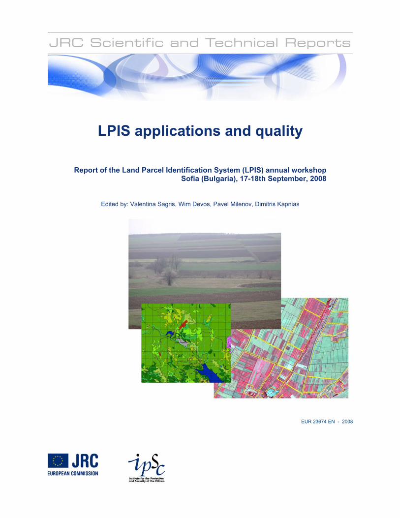
2.1.4. Benefits of applying GI practices supporting interoperability and modularity were illustrated by the
Maltese presentation, where a contractor implemented a web-based and centralised IACS for the
complete management of all CAP processes, including LPIS update, cross-checks, management of
claims, OTSC, and so on. This integrated solution facilitates the sharing of data and responding to
evolving EU regulations. The Maltese system was not built “from scratch” but a customization based
upon recuperated “pre-packaged” solutions proven by other Paying Agencies.
2.1.5. A good example of the data interoperability comes from the Netherlands that operates a LPIS that is
derived from the topographic map, which is an authentic registration (i.e. an official reference layer). But
the system also deploys recent aerial photographs and the Cadastre layers. The system itself creates
spatial layers with the agricultural parcels (from farmer declaration) and with the results from the OTSC
and CwRS activities.
2.1.6. Use of land for agricultural activities is a concept that is explicit in the Regulations but from the point of
view of mapping, the concept of land cover is probably more appropriate. In any condition, mapping
land at large scales all over Europe requires standardization of the mapping categories and the FAO
Land Cover Classification System (LCCS) offers clear advantages over the use of a single EU mapping
legend. However, it remains an open question if that LCCS classification enables a better
representation of the maximum eligible area than the land use delineation.
5
Figure 2.1 What kind of LPIS does EC need? – we have all of them! From presentation F.Slaviero & J. ATTARD ‘LPIS experience in Malta’
2.2. Database issues & management quality
2.2.1. Orthoimagery has been extensively used by the EU Member States for the purposes of implementing
and maintaining LPIS. Recent advances of digital image acquisition systems offer many options in
terms of spatial, radiometric and spectral resolution so a common core set of specifications in LPIS
context would support the quality control process for both the MS administration and the EC. Such
specification based on JRC's “Guidelines of best practice” will provide a framework for assessing the
imagery independent of the imaging system and platform, ensuring sufficient image quality and effective
metadata. The first draft set of the proposed quality measures was presented to the MS for discussion.
2.2.2. A practical example of a LPIS quality upgrade is presented by the Swedish administration. The process
was triggered by remarks by DG AGRI after audit regarding inconsistency of the system as a mix of
physical block/farmer’s block, incorrect location of boundaries, inclusions of ineligible land within the
boundaries and the use of tolerances during initial quantification. In brief, stricter application of rules
was expected and for this a full re-survey of the LPIS during a two year period was launched. The
process, mainly based on a systematic survey with new orthophotos would also apply new techniques
for change detection such as -classification of satellite data, laser scanning; and tree count. The
reference parcel concept was redefined as a farmer’s block delineating only eligible land. It was also
evident that slight interpretation differences remain between the SE authorities and the EC, but SE is
implementing the EC expectations.
2.2.3. In German federal state of North Rhine-Westphalia (NRW) a continuous update of process is driven by
a maintenance request system to gather, process and control change request for its physical blocks and
landscape elements. This request system has been integrated into the workflow of the original LPIS
software, LaFIS-LFK and is as such linked to e.g. the OTSC module. The workflow starts when the
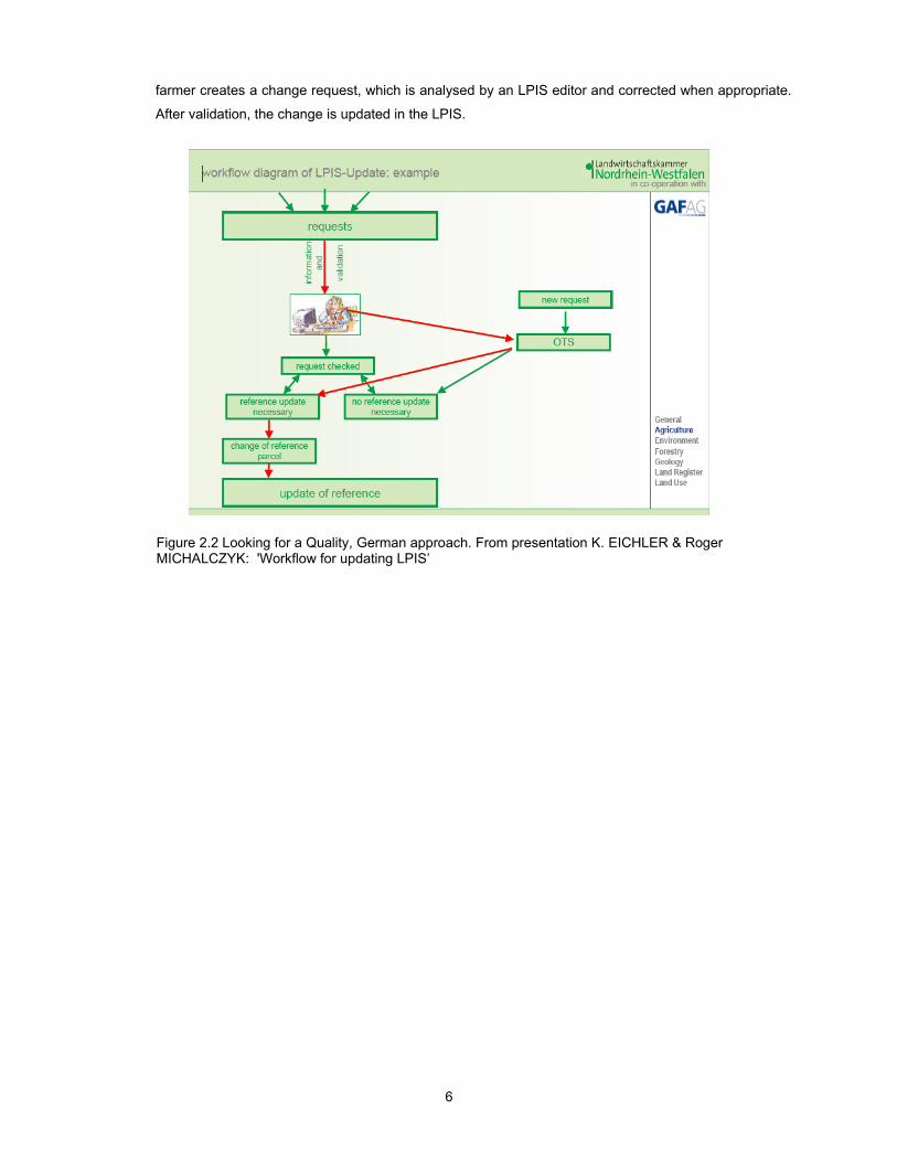
6
farmer creates a change request, which is analysed by an LPIS editor and corrected when appropriate.
After validation, the change is updated in the LPIS.
Figure 2.2 Looking for a Quality, German approach. From presentation K. EICHLER & Roger MICHALCZYK: 'Workflow for updating LPIS’

7
2.2.4. In general Quality Management practice, a quality policy is implemented through two strategic
approaches: quality control and quality assurance. Both approaches employ the same: quality
inspection tools (tests). Quality assurance (QA) is oriented to provide quality on a continuous basis and
seems therefore the preferred approach for a dynamic institutional system such as LPIS. QA
implementation consists of the management of
requirements and of data governance. This latter
requires the establishment of a conformance quality
level, planning of recurrent quality assessment
(inspections) and reporting. Geographic information
data, quality is governed by ISO standards 19113,
19114, 19115 and 19138. These provide a framework
for evaluation procedures, documentation and
reporting and any QA framework built on these
standards will provide a transparent basis for drawing
conclusions and agreeing on improvements.
Figure 2.2. One more question from UK.
2.3. LPIS and second pillar of the CAP
2.3.1. Rural Development is gaining more importance through increased modulation and Member States need
to establish controls to guarantee the correct disbursement of all payment under both pillars. GIS
technology, linking maps with databases is a key component of efficient control system. Harmonization
of national procedures is required to link pillar I and II payment systems to facilitate the de minimis
option and to ensure that pillar I type controls are properly transposed into pillar II. Integrating additional
databases related to landscape features, environmentally sensitive areas or water resources can
present difficulties in respect of their availability, compatibility, and precision. Ireland developed and
demonstrated a solution to address these interoperability issues. One element is web-based application
for rapidly update the LPIS.
2.3.2. New member state we will fully introduce CC during the next tree years, in the meantime many of them
already on the way to integrated CC data into their LPIS. Slovakia started to integrate cross compliance
and RDP layers into its LPIS and some layers are already fully integrated (e.g. Nitrogen directive, Wild
Bird protected areas, Biotop –Habitats and species, average slope, average altitude, LFA, soil quality/
bonity) , others are still in process (Sewage sludge, Groundwater directive, semi-natural and natural
green lands). All information is available on the pre-printed forms and accessible via a public web
application.
8
2.4. Lessons learnt during the creation of LPIS
2.4.1. Bulgaria has achieved full coverage with physical blocks by February 2008. Early in September 2008 a
first update was performed, based on field inspections and the ongoing digital ortho-photo map update.
The existing LPIS is now extending by the integration of 5 topical data sets: the data for Less
Favourable Areas, the rural development aid scheme data, the NATURA 2000 data and LUCAS data
(currently some 8 100 sampling points). In addition the Vineyard register currently contains 5 008 blocks
representing 49 937 ha.
2.4.2. The Bulgarian LPIS development is occurring within the National Spatial Data Infrastructure (NDSI). A
NSDI is the national embodiment of the concept and implementation of the INSPIRE Directive. Progress
so far mostly relates to the institutional framing and Bulgaria has produced and approved a NSDI action
plan and launched a questionnaire to governmental institutions and spatial data holders. The State
Agency for Information Technology and Communication is designated as the responsible institution.
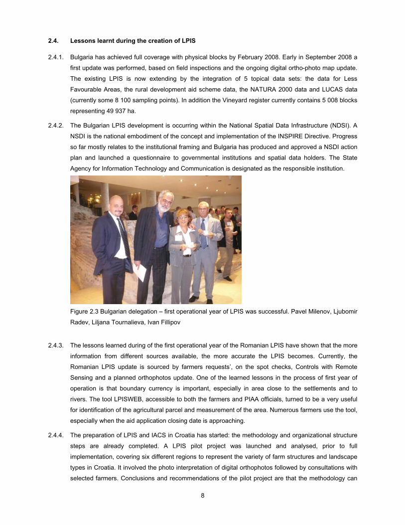
Figure 2.3 Bulgarian delegation – first operational year of LPIS was successful. Pavel Milenov, Ljubomir
Radev, Liljana Tournalieva, Ivan Fillipov
2.4.3. The lessons learned during of the first operational year of the Romanian LPIS have shown that the more
information from different sources available, the more accurate the LPIS becomes. Currently, the
Romanian LPIS update is sourced by farmers requests’, on the spot checks, Controls with Remote
Sensing and a planned orthophotos update. One of the learned lessons in the process of first year of
operation is that boundary currency is important, especially in area close to the settlements and to
rivers. The tool LPISWEB, accessible to both the farmers and PIAA officials, turned to be a very useful
for identification of the agricultural parcel and measurement of the area. Numerous farmers use the tool,
especially when the aid application closing date is approaching.
2.4.4. The preparation of LPIS and IACS in Croatia has started: the methodology and organizational structure
steps are already completed. A LPIS pilot project was launched and analysed, prior to full
implementation, covering six different regions to represent the variety of farm structures and landscape
types in Croatia. It involved the photo interpretation of digital orthophotos followed by consultations with
selected farmers. Conclusions and recommendations of the pilot project are that the methodology can
9
be directly used for the national LPIS implementation, but attention should be paid on the training
program, the availability of data of homogeneous quality and ancillary data (Cadastral data linked with
the Farm register). Additional development is needed on the digitization of landscape features, in line
with the definition of GAEC’s and area-related measures of the RDP as well as on the area
measurement methodology.
2.5. Research on IACS-LPIS
2.5.1. Electronic information exchange is increasingly important because of food safety regulations,
environment measures and reporting, and competitive issues. There are three dimensions of
information exchange: along the processing chain, the farms chain, and the public administration chain.
Currently reuse of information is very difficult as exchanged messages are specified for application
between specific nodes and (international) standardization is lacking. The urge for harmonisation is
coming from cross sector exchange between the dimensions: the re-use of data in all chains and nodes,
in the farm, public administration, and food production chains. The AgriXchange platform is set up to
improve the cooperation and the interoperability of standards for information exchange in the agriculture
domain trough pilot projects and test bed structures to improve interoperability, by defining common
data definitions, schemas and profiles.
2.5.2. Historically, different MS have chosen different solutions for the establishment of their LPIS as there are
no standardized structures. The University of Delft and the JRC ran a study to design a data model for
IACS/LPISs based on the draft ISO-standard ISO19152 and (Land Administration Domain Model:
LADM) and the IACS/LPISs (LPIS Core Model: LCM). The resulting data model implies the
collaboration/integration of LADM and LCM, with some further extensions as collaboration rules. Some
basic issues with the collaboration model are the registration of land use rights, geometry/topology,
temporal data management, registration of farming limitations etc. Sample instance level diagram
enable an easy understanding of the complex model structure. However, a definite prerequisite for the
usefulness of the collaboration model is that the land administration (cadastral) data reflect the true
terrain condition.
2.5.3. The intrinsic quality of an LPIS depends on the frequency and magnitude of the discrepancies in area
between that declared by farmers and officially registered. Managing that quality depends on the
capacity to identify and explain the causes of these area discrepancies perceived as anomalies by
national CAP payment agencies and enact upon that information. Using Control with Remote Sensing
(CwRS) campaign data, GIS and ecological methodologies the JRC assessed the quality of LPIS’s by
identifying the diversity of the existing anomalies, after adapting the ecological sampling method for
image-based anomaly detection. The observed anomalies assemblages by control zones were
analysed in order to establish the spatial pattern of the anomalies’ distribution. It showed that the twelve
zones surveyed can be grouped into four different clusters, each individually correlated with the
presence of certain categories of LPIS anomaly. Clusters seem related to the presence of natural and
anthropogenic landscape features, or are typified by anomalies, which stemmed from the LPIS
management processes. The results obtained suggest that the LPIS quality can be improved by
identifying the critical points along the LPIS management chain, by using landscape ecological

10
methodologies to explain the causes of the clusters observed; and by extrapolating the results in the
CwRS risk analysis to perform ex-ante LPIS anomalies risk map.
2.6. The LPIS Questionnaire
2.6.1. This questionnaire on the status of LPIS was organized in the framework of the workshop. It is a
continuation of our efforts on gathering information about LPIS systems in the EU. The previous
questionnaire1 was organized in 2006 and was mainly focused on issues of the sources of information,
on the methodological approaches in use for the LPIS update with particular attention on the
compliance of the LPIS in respect to the 75%/90% rule. The questionnaire of 2008 continues to look for
LPIS update techniques, trying to identify what is new. However, in comparison to the questionnaire of
2006, this year higher attention was given to thematic consistency of geographic data sets stored in
LPIS. The EU regulations call for an as-precise-as-possible quantification of the area which is eligible
for direct payments. Therefore, a logical organisation of the geographic data and thematic content (e.g
classification of land use/land cover) should provide for a maximum reflection of concepts, which laid
down in the Regulation. In order to keep the survey short and provide space for new questions we
skipped: the topics LPIS initial creation, data dissemination/integration and Web issues.
2.6.2. The structure of the questionnaire as follows: after a short (1) general information part questions were
dedicated to (2) the structure of the database for core LPIS data - data sets effecting the primary task of
LPIS – delineation of the eligible area. Further on questions were focused on (3) thematic content of
those data sets, classification of eligible area types, spatial representation of land uses eligible for
different payment schemes. And finally, (4) group of questions about quality issues and update. All
together, there were forty questions.
2.6.3. A follow-up action in the wake of the workshop ensured that a high number of completed questionnaires
could be collected and analysed. The full analysis of the questionnaire is beyond the scope of this
report, only the key LPIS type numbers are shortly presented. Full report on the questionnaire can be
found http://mars.jrc.ec.europa.eu/mars/About-us/GeoCAP
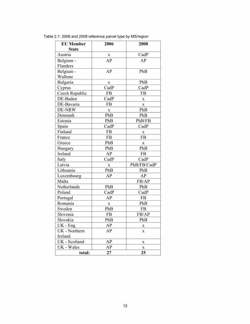
2.6.4. This year we received answers form 25 MS or regions/federal states, which is by two responses less
then compared to 27 answers of 2006. Only 20 MS/regions participated in both questionnaires. Table
2.1 shows responded MS to both questionnaire as well as their answers on question about type of
reference parcel in use.
2.6.5. Five countries indicated that their system uses a mixture of reference types or operates more than one
type. Four MS/regions (Wallonie, Ireland, Sweden, and Portugal) out of the 20 who answered both
questionnaires, seem to have changed their reference parcel type or re-considered their data concepts.
2.6.6. It is interesting to notice that four of MS/regions from 20, which answered both questionnaires, have
changed reference parcel type or re-think/redefined its definitions (*Belgium – Wallone, Ireland,
Sweden, and Portugal). The summary by reference parcel type for both dates is presented in the figure
2.4. In addition, four countries indicated that they use mixture of reference types or more than one type.
1 JRC IPSC/G03/P/SKA/pmi D(2007)(7111): P.Milenov, ‘LPIS Update in EU Member States (Methods, Technology, Organization)’

11
Cases of RP type change and mixed systems are highlighted in the table 2.1 by ** mark. Figure 2.4
clearly shows that among MS/regions answered questionnaire in 2008 those who have opted for
production block types (farmer’s or physical block) of RP are dominating. However, it does not mean yet
that considerable turn to Physical block system took place for the period of these two years.
Reference Parcel types 2006 2008 Physical block 8 11 Farmer's block 5 7 Agricultural parcel 9 2 Cadastral parcel 5 5
Figure 2.4: 2006 (n = 27) and 2008 (n = 25) main reference parcel distributions
2006
PhB
FBAP
CadP
2008
PhB
FB
AP
CadP
12
Table 2.1: 2006 and 2008 reference parcel type by MS/region
EU Member State
2006 2008
Austria x CadP Belgium - Flanders
AP AP
Belgium - Wallone
AP PhB
Bulgaria x PhB Cyprus CadP CadP Czech Republic FB FB DE-Baden CadP x DE-Bavaria FB x DE-NRW x PhB Denmark PhB PhB Estonia PhB PhB/FB Spain CadP CadP Finland FB x France FB FB Greece PhB x Hungary PhB PhB Ireland AP FB Italy CadP CadP Latvia x PhB/FB/CadP Lithuania PhB PhB Luxembourg AP AP Malta FB/AP Netherlands PhB PhB Poland CadP CadP Portugal AP FB Romania x PhB Sweden PhB FB Slovenia FB FB/AP Slovakia PhB PhB UK - Eng AP x UK - Northern Ireland
AP x
UK - Scotland AP x UK - Wales AP x
total: 27 25
13
3. Conclusions
3.1.1. The workshop revealed that Member States continue their search for better solutions. Some are
upgrading their LPIS by changing Reference Parcel type while others indicate to have implement some
kind of mixed system. The decision for upgrade is to some extend triggered by the findings of auditors.
A clarification of the semantics behind the concepts became evident from presentations and
discussions.
3.1.2. Meeting the minimum quality requirements is essential for Member States to avoid financial correction
by the EC, but some are also concerned on quality issues for tracking changes and facilitating update
automations. Both objectives consistently drive development of the systems that basically hold the 1st
pillar data. In addition, as illustrated by some presentations. Member States are now striving to
accommodate for cross-compliance and rural development data – a sporadic development by now,
where review and dissemination of experiences of the best practice examples is essential.
3.1.3. The workshop confirmed again that LPIS creation and administration face the same challenges and
could apply the same technologies as would any of the spatial databases that are subject to European
harmonization as theme of the INSPIRE Directive. The presentations provide a wide range of topical
illustrations of this.
3.1.4. However, the content of the presentations, as well as the questions and comments raised during the
discussion, revealed that there is a lack of common understanding of the LPIS elements, scope, rules
and update processes, which definitely emphasize the importance of a core model.
3.1.5. Additionally, the community seems little conscious of the advantages of interoperability and many LPIS
continue their standalone operation and independent system development. LPIS custodians remain
focused on their daily managerial problems and on issues directly related to the DG AGRI audits.
3.1.6. As a result, insufficient attention is paid to the conceptual approach of the LPIS, which is an
indispensible basis for common documentation and for the development exchangeable components.
GI modelling and standardisation methodologies are considered too abstract and costly. Addressing this
situation and making more substantial progress, requires both a change in attitude and motivation from
the LPIS custodians as well as the broadening of this community by involving the contractors, the
technical experts and academics.
3.1.7. The outcome of this technical workshop will be presented during the coming Annual MARS PAC
Conference in Ljubljana, December 2008.

14
Annex 1: Workshop Agenda
1st day, Wednesday, 17 September
9:00-10:30 Session1: Opening
9.00-9.10 Welcome JRC: Wim DEVOS 9.10-9.20 Welcome ASDE & SAITC: Ivan FILIPOV & Plamen VATCHOV 9.20-9.30 Welcome Ministry of Agriculture and Food, BG: Ivan KARCHEV 9.30- 10.00 Wim DEVOS & Vincenzo ANGILERI (JRC)
CAP Health Check: LPIS and second pillar of the CAP 10:00-12:30 Session 2: Geomatics in domain of the CAP
Chairman: Dimitris Kapnias10.00-10.20 Peter van OOSTEROM
INSPIRE process, standardization of geoinformation in Europe
Coffee break
Session 2: continue 11.00-11.20 Valentina SAGRIS (JRC) LPIS Conceptual Model
11.20-11.40 Fabio SLAVIERO (Abaco, IT) & Johann ATTARD (MT) LPIS experience in Malta within a new generation of Integrated Administration and
Control Systems 11.40-12.00 Jakob KROON, Ruud SCHIPPER and Janette DIJK (NL) LPIS structure and procedures in the Netherlands 12.00-12.15 Pavel MILENOV (JRC) Standardization of the land cover classes using FAO Land Cover Classification
System (LCCS)
Lunch break
14:00-15:30 Session 3: Database issues & management quality Chairman: Pavel Milenov
14.00-14.20 Dimitris KAPNIAS & Pavel MILENOV(JRC) Digital Ortho-Imagery Specifications 14.20-14.40 Anders FORSBERG & Viktoria BJÖRNSTRÖM (SE) Increased quality of the Swedish LPIS 14.40-15.00 Karin EICHLER (GAF, DE) & Roger MICHALCZYK (NRW, DE) Workflow for updating LPIS - The reference maintenance request system in
North Rhine-Westphalia (NRW) 15.10-15.30 Valentina SAGRIS (JRC) Quality issues in LPIS: Towards quality assurance
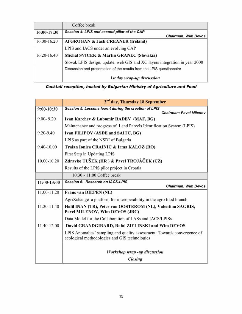
15
Coffee break 16:00-17:30 Session 4: LPIS and second pillar of the CAP
Chairman: Wim Devos16.00-16.20 Al GROGAN & Jack CREANER (Ireland) LPIS and IACS under an evolving CAP 16.20-16.40 Michal SVICEK & Martin GRANEC (Slovakia)
Slovak LPIS design, update, web GIS and XC layers integration in year 2008 Discussion and presentation of the results from the LPIS questionnaire
1st day wrap-up discussion
Cocktail reception, hosted by Bulgarian Ministry of Agriculture and Food
2nd day, Thursday 18 September 9:00-10:30 Session 5: Lessons learnt during the creation of LPIS
Chairman: Pavel Milenov9.00- 9.20 Ivan Karchev & Lubomir RADEV (MAF, BG) Maintenance and progress of Land Parcels Identification System (LPIS) 9.20-9.40 Ivan FILIPOV (ASDE and SAITC, BG) LPIS as part of the NSDI of Bulgaria 9.40-10.00 Traian Ionica CRAINIC & Irma KALOZ (RO) First Step in Updating LPIS 10.00-10.20 Zdravko TUŠEK (HR ) & Pavel TROJÁČEK (CZ) Results of the LPIS pilot project in Croatia
10:30 - 11:00 Coffee break 11:00-13:00 Session 6: Research on IACS-LPIS
Chairman: Wim Devos11.00-11.20 Frans van DIEPEN (NL) AgriXchange a platform for interoperability in the agro food branch 11.20-11.40 Halil INAN (TR), Peter van OOSTEROM (NL), Valentina SAGRIS,
Pavel MILENOV, Wim DEVOS (JRC) Data Model for the Collaboration of LASs and IACS/LPISs 11.40-12.00 David GRANDGIRARD, Rafal ZIELINSKI and Wim DEVOS LPIS Anomalies’ sampling and quality assessment: Towards convergence of
ecological methodologies and GIS technologies Workshop wrap -up discussion
Closing
16
Annex 2: Abstracts of presentations
Session 1: Opening and introduction to the Workshop
Wim Devos & Vincenzo ANGILERI
EC-JRC, Institute for Protection and security of the Citizen, Agriculture unit
CAP Health Check: LPIS and second pillar of the CAP Having gained experience after implementing the 2003 CAP reform, the EU is now in a position to assess whether the reformed CAP is working efficiently. This assessment process, the “Health Check” is not intended as a major reform but as an effort to streamline and to modernize the CAP. It targets three main objectives:
(i) Simplify policy and better target direct support (ii) Respond to market opportunities and price crises by removing supply controls (iii) Strengthen RD policy to respond to new challenges
In each of these areas, the Commission has presented legal proposals (COM 2008, 306/3, 20/5/2008), and the resulting regulatory modifications are expected to be adopted in December, 2008. Two legal proposals will have a direct relevance to IACS/LPIS. On the direct aid schemes, the main proposals are that MS applying SPS will be allowed to adjust their SPS model by moving towards flatter payments rates per entitlement, whilst MS applying SAPS will be permitted to extend the system until 2013. The proposals also involve the abolishment of the obsolete set-aside obligation and the merger of most remaining coupled payments into SPS, with only a few exceptions in less favourite regions where economic alternative are few. The Health checks addresses cross-compliance by stressing the link between the farmer responsibility and his obligations in the areas of environment, and public, animal and plant health . For cross-compliance, the proposed measures include: (i) the withdrawal of certain SMR or articles in them considered irrelevant or unrelated to farmer responsibility (SMR1, 5 & 7) and (ii) the introduction of a new GAEC issue on the protection and management of water with two standards that also intend to retain environmental benefits from set-aside. Moreover, in the issue of minimum level of maintenance, the proposal explicitly defines the landscape features to be retained. The agricultural sector faces several challenges that are considered more acute now than in 2003. These challenges are: an increased need for management of production risks, an adjustment towards climate change issues, a more efficient management of water, a response to the opportunities offered by bioenergy and the preservation of biodiversity. In the proposal these can be addressed in specific actions in some rural development measures and become more prominent due to the strengthened modulation mechanism. According to the principles of implementing RD MS shall make use of IACS for administrative checks and this may create new challenges for IACS/LPIS. A clear evaluation of the strategy towards simpler and more integrated systems should be considered together balancing institutional versus technological arguments. The goal is to achieve optimal and consistent use of all available data.

17
What does all of this mean for the current LPIS? Some additional requirements for GIS data will inevitably emerge, accommodating a further simplification and supporting interoperating between the different CAP Regulations. The current trend is that schemes become area based and ever more decoupled, and this extends the range of spatial data and increases the demand for interoperable and high accuracy LPIS data. This will also require some consideration on the eligibility concept over the various, but interacting, aid schemes.
Session 2: Geomatics in domain of the CAP
Peter van Oosterom Delft University of Technology, the Netherlands INSPIRE process, standardization of geoinformation in Europe This contribution consists of three parts. The first part of the presentation gives an overview of INSPIRE, which is a Directive proposed by the European Commission in July 2004 setting the legal framework for the establishment and operation of an Infrastructure for Spatial Information in the European Community. The purpose of such infrastructure is to support the formulation, implementation, monitoring activities and evaluation of Community policies and activities that may have a direct or indirect impact on the environment at various levels of public authority, European, national and local. INSPIRE should be based on the infrastructures for spatial information that are created and maintained by the Member States. The components of those infrastructures include: metadata, spatial data themes (as described in Annexes I, II, III of the Directive), spatial data services; network services and technologies; agreements on data and service sharing, access and use; coordination and monitoring mechanisms, processes and procedures. An overview of the INSPIRE process is given: obtained results until now (with focus on the data specification) and timetable for the future are given. The second part of the presentation focuses on INSPIRE cadastral parcels. The INSPIRE Directive focuses on the geographical part of cadastral data. In the INSPIRE context, cadastral parcels will be mainly used as locators for geo-information in general, including environmental data. As much as possible, in the INSPIRE context, cadastral parcels should be considered as single areas on Earth surface under homogeneous rights, forming a partition of national territory. Cadastral parcels are considered in the INSPIRE scope if they are available as vector data. Rights and owners are out of the INSPIRE scope. The last part of the presentation describes the status of ISO 19152, in which the Land Administration Domain Model (LADM) is defined. Land administration is a large field; the focus of this standard is on the part of land administration that is mainly connected to real properties, land ownership, and the geometrical (spatial) components thereof. The LADM will serve at least two important goals: (1) avoid reinventing and re-implementing the same functionality over and over again, but provide a extensible basis for an efficient and effective land administration system development based on a Model Driven Architecture (MDA), and

18
(2) enable involved parties, both within one country and between different countries, to communicate based on the shared vocabulary (an ontology) implied by the model. The second goal is very important for creating standardized information services in an international context, where land administration domain semantics have to be shared between countries (in order to enable necessary translations). Important conditions during the design of the model are: it should cover the common aspects of land administration all over the world, should be based on the conceptual framework of Cadastre 2014 (Kaufmann & Steudler, 1998), should follow international ISO standards, and at the same time the model should be as simple as possible in order to be useful in practice.
Valentina Sagris & Wim Devos EC-JRC, Institute for Protection and security of the Citizen, Agriculture unit
LPIS Core Conceptual Model The LPIS Core conceptual Model (LCM) was announced at LPIS workshop in 2007 and its first version was published in discussion paper on GeoCAP web page http://mars.jrc.it/marspac/GEO-INF/default.htm in June, 2008. By the same time we were contacted by the team preparing ISO 19152 standard for Land Administration Domain Model with proposal to have an annex in standard for LPIS/IACS use. The purpose was, fist of all, to reach an agreement on common definitions of concept, spatial features and core data structure. Further on, open and transparent rules for quality assessment and conformity test can be established. The scope of this work was as follows: (i) analysis the European regulatory requirements; (ii) analyse National LPIS implementations for ‘As-is analysis; (iii) produce first-cut core conceptual model for LPIS and discuss it among MS. Step 1 - Analysis of the requirements- is reflected in a discussion paper in a textual way. We also produced a database version of it and used it as starting model for UML modelling process. Further on, we defined the boundaries of the model through its packages and mapped basic spatial and non-spatial concepts of IACS system. We found that there are two main spatial concepts: (i) Agricultural parcel (AP) which class object in IACS; subject of payment and control and not necessarily mapped as a spatial object in LPIS and (ii) on the other hand, Reference parcel (RP) which is concept of LPIS for spatial referencing of AP and determining of area. This spatial object represents core data layer maintained and updated in LPIS. In order to reflect all different types of RPs (step ii) which are implemented in MS we analysed available meta-data, and at the end a model where the general RP class has 4 subtype classes was proposed. All subtypes inherit main (obligatory) attributes from general class, but can have their own type specific attributes. For feature development we plan to concentrate on the following spatial concepts relevant to CAP health check: CAP Health Check: 4 spatial units in the Regulation we need to find
19
place in the model: crop land use crop group forms Agricultural Parcel Eligible land land cover, forms production block Holding sum of production blocks
Fabio Slaviero 1 & Johann Attard2 1. Abaco S.r.l, Italy 2. Maltese Ministry for Resources and Rural Affairs LPIS experience in Malta within a new generation of Integrated Administration and Control Systems The Ministry for Resources and Rural Affairs decided at the end of 2007 to issue an international competition to acquire a new IACS, including a new LPIS system. The major target was to be able to collect aid applications, especially SPS campaign 2008, starting in March 2008, and to perform OTSC within August 2008. The major achievement was to have the full system up and running in 6 months, whereas the old information was completely re-used and the new system is supporting also the old information originally stored in separate systems. This new IACS, web-based and centralised, allows now a complete management of the whole CAP process, including LPIS update, cross-checks, management of claims, OTSC, and so on, within an integrated solution facilitating the sharing of data, and responding to the latest EU regulations and the JRC advices (like the core LPIS model, differentiating Reference Parcels from Agricultural Parcels). The system was not built “from scratch” thanks to the availability of a proven “pre-packaged” solution already working for several other Paying Agencies, already supplying the EU CAP requirements, and being flexible and customisable. The current solution is based on spatial functionalities, with a centralised approach, allowing also to gather real-time information in several processes, thus anticipating possible errors. The overall rate of farmer’s complaints dropped dramatically, with less administrative work, allowing to concentrate on data quality. Since the updates of the IACS are responsibility of the solution vendor , the Maltese Paying Agency now concentrates on processes and other activities. Eligibility is determined almost automatically using ease-to-use tools for CAPI, and passing through a quality assessment process. OTSC are performed through a comprehensive interface for CwRS. Applications are mostly filled automatically with the existing information coming from the different modules and a new concept of Graphical Rural Plan (provided by the farmer itself) has been introduced as an intermediate step to reduce administrative work and errors during the aid application
20
collection. LPIS becomes so, a valuable source of information in order to diminish administrative work and cross-checks during the aid application collection, plus it forms the basis for the OTSC, whereas feedbacks are consistently added to the system, thus achieving a continuous update of the LPIS itself and proper traceability for the EU CAP processes. The IACS for the Maltese Ministry for Resources and Rural Affairs is the latest successful achievement of Abaco s.r.l. Coming from a broaden Territory and Resource Planning background, Abaco is the producer of a pre-packaged, modular, open-standard and complete Integrated Administration and Control System (IACS), responding to EU requirements and used by more than seven Paying Agencies.
Jaap Kroon*, Ruud Schipper & Janette Dijk, National Service for Implementation of Regulations LPIS structure and procedures in the Netherlands Characteristics of NL LPIS reference layer The LPIS NL has chosen for the physical block as the reference unit (according to Coun. Reg. 1593/2000 and art. 20 of 1782/2003). Why physical block? • most in line with the actual situation in the field and with practice of land use • nation-wide and updated Topography file (called: Top10) was already available NL Topography file is now officially a Basic Register, which implies that government institutions are legally bound to use available data and to report inaccuracies. It assures a high level of quality, update and maintenance is carried out by the Cadastre. Some features of Top10:
coverage: whole NL territory, including non-agricultural sources: current digital aerial photographs , field reconnaissance's carried out by 40 topographers currency: until 2008 update cycle was 4 years (25% each year), since 2008 - 2 years (50% each year), scale: 1 : 10.000
Data layers/attributes in LPIS
For the use as a reference layer in the NL LPIS an extract is made from the Top10, containing only ‘agricultural blocks’ or nature reserve areas. The selection is based on Land Use Codes of Top10 to classify agricultural blocks and nature reserve areas, e.g. meadow, arable land, pasture, orchard, tree nursery, heath, mixed forest. Boundaries are ‘hard boundaries’ like roads, waterways, forest, buildings, hedge-banks, surfaced lanes. Boundaries between arable land and pasture (‘soft boundaries’) within 1 block are removed.
Determination of the eligible area in NL LPIS reference layer
Landscape features which are depicted as plane objects have their own code in Top10.

21
Consequently, these objects do not become part of the RP layer, e.g. marsh and reed, pool/ponds, hedge-banks, bush, waterways. Landscape features which are depicted as line objects, are considered essential parts of the ‘good agricultural practices’, in line with Comm. Reg. 796/2004 art. 30(2). in particular hedges, walls and ditches, may be considered part of the fully utilized area on the condition that it does not exceed 2 meters
Attributes in LPIS: location (unique identification with XY coordinates); area; land use code; year of actualisation, geometry
Complementary data in NL LPIS. Besides this reference layer NL LPIS also consists of: • aerial photographs with nation-wide coverage, historical (2000, 2003, 2005, 2006, 2007)
and current (2008). Current photo has 25 cm resolution, infra red included, fly height 3653 m.
• agricultural parcels layer: all agricultural parcels declared for aid support starting from 2001.
• layers of detection of OTSC and Remote Sensing (since 2005) with area and crop information
• Top10 and Cadastre layers
Cross checks (art. 24 796/2004): • agricultural parcels vs reference parcels: double declared AP’s and overclaimed RP area
2 parcels lying in 1 reference parcel causing overdeclaration • between RP and AP (geometry check)
- reference parcels which have changed physical boundaries in the ongoing campaign (according to applicant, or OTSC) are marked with an expiry date. - all agricultural parcels lying on these reference parcels are double-checked on the basis of the calculated area (GIS) and the aerial photo - AP overlapping 3 RP’s with expiry date: check by calculated area and aerial photo
Quality of NL LPIS.
It efficiently reflects land use and declaration because it fully complies with 75%/90% rule under Art 6 of Reg. 796/04, e.g. 2006: 84,89% (national level) and 2007 : 87,86% (national level). It has high level of currency with respect to 2-years update cycle and precise update procedures (field reconnaissance's). System supports checks eligibility of parcels by the codes (pasture, forest, nature reserve area) in Top10.
22
Pavel Milenov EC-JRC, Institute for Protection and security of the Citizen, Agriculture unit Standardization of the land cover classes using FAO Land Cover Classification System (LCCS) In the beginning of the presentation, the basic concepts of the land cover and land use from the point of view of INSPIRE and CAP regulation, are outlined. Later, the role of the land cover, as crucial element in the LPIS is emphasized. Special attention is given to explain the difference between description and classification of an object and feature. It is stressed that the land cover/land use categories, used in the LPIS by different EU MS needs to be standardized. In this respect the potential use of the FAO Land Cover Classification System is shown. In the final part of the presentation, some examples of concept generation through the LCCS of land cover classed used in the LPIS are presented. Main question that the presentation is trying to discuss further is the ability of the LCCS framework to delineate something that is a better representation of the maximum eligible area (in the frame of IACS-LPIS), than the land use delineation

23
Session 3: Database issues & management quality
Dimitrios Kapnias & Pavel Milenov EC-JRC, Institute for Protection and security of the Citizen, Agriculture unit Orthoimage specifications The orthoimage has been extensively used by the EU Member States for the purposes of implementing and maintaining LPIS. There is a wide diversity of orthoimage amongst the MS as the recent advances of digital image acquisition systems provide a great number of options in terms of spatial, radiometric and spectral resolution. The creation of a common core set of specifications for the orthoimage produced for LPIS aims in supporting the quality control process for both the MS administration and the EC. Whereas JRC's Guidelines of best practice support the production process, the proposed specifications will provide a framework for assessing the quality of the produced orthoimage independent of the imaging system and platform. The scope is to establish a core set of measures to ensure sufficient image quality for the purposes of LPIS and also to define the set of metadata necessary for data documentation and overall job tracking. The first draft set of the proposed quality measures is presented to the MS for discussion.
Anders Forsberg & Viktoria Björnström Swedish Board of Agriculture
Increased quality of the Swedish LPIS During 2008-2009 Sweden is undertaking a large work to increase the quality of the LPIS. The presentation describes the reason, how the work is done and how the LPIS will be updated in the future. Why do we need to improve the quality? Remarks by DG AGRI after audit in June-2007:
•Inconsistent systemmix of physical block/farmers block •Reference parcels with incorrect location of boundaries •Reference parcels with ineligible land •Tolerances used when definingmaximum eligible area
How do we improve the quality? •Consistent system •Review of approved eligible land •Defining quality requirements •Full survey of LPIS 2008-2009•Plan for continuous LPIS update
System change to farmers block Sweden wants a one-layer LPIS containing only eligible land. This is not possible for physical block according to the commission. After review in 2008 from physical block to farmers: block area without tolerance =maximum eligible area. Rules for eligible pasture will become stricter.
Swedish interpretation of quality requirements: 2.5 m RMS without systematic errors, which gives LPIS update quality requirements to level of errors larger than 2.5 m and 0.01 ha shall be corrected. During total LPIS survey every reference parcel will be

24
checked. Main approach is that found errors can be corrected at office if possible (screen-digitized using ortophotos)otherwise after field inspection (PDA with GPS). Project budget during 2008-2009 is approx. 25 M€
Plan for continuous LPIS update • Systematic check of areas with new orthophotos • Test of new techniques for change detection such as -Classification of satellite data, -
Laser scanning; -Tree count
Karin Eichler1 & Roger Michalczyk2 1. project manager, GAF AG, Munich, Germany 2. Landwirtschaftskammer NRW, Gernamy
Workflow for updating LPIS - The reference maintenance request system in North Rhine-Westphalia (Germany) The setup of the LPIS of the German federal state of North Rhine-Westphalia (NRW) was carried out in 2004 based on physical blocks. In 2007 landscape elements have been added. Now the continuous update of the reference system, containing 409.000 physical blocks and 82.000 landscape elements, gets a challenge. For that reason NRW has introduced as other German federal states a maintenance request system to gather, process and control change request for physical blocks and landscape elements. This system has been integrated into the original workflow of the LPIS software LaFIS-LFK by GAF AG. A request is necessary to trigger the start of the update. There are different sources of requests to update a reference parcel. Independent of the request, the update follows a workflow, which is integrated in the software: The farmer marks with an advice point the physical block or landscape element that needs to be updated in his/her point of view (e.g. because of enlargements of an industrial area inside this physical block). These advice points are imported in the LPIS system. An LPIS editor analyses the request of the farmer and checks whether the physical block/landscape element is to be corrected. This check can for example be done by on-the-spot control. On-the-spot control is also part of the functionality of the LaFIS-system. Afterwards the LPIS-editor validates the changes. This then leads to an update of the reference system.
25
Valentina SAGRIS & Wim Devos EC-JRC, Institute for Protection and security of the Citizen, Agriculture unit Quality issues in LPIS: Towards quality assurance As an institution LPIS should comply with ‘good management practice’ standards including quality policy. Quality policy is based on two strategic approaches: quality control and quality assurance, both of them make use of the same tool: quality inspection (test). Quality assurance (QA) – oriented to build quality into information system on a continuous basis, from conception through implementation and update – seems to be the most appropriate strategy for such a dynamic system as LPIS. It consists of two parts: (i) management of requirements and (ii) data governance. The first one is based on thorough documentation of all requirements to the system and establishing of follow up procedure: allocate recourses->nominate responsible->establish deadline->check result. Data governance or management of data quality is one of the most important quality issue for LPIS consists of:
• Establishing of the Conformance quality level • Planning*of quality assessment (inspections) for the data • Reporting data quality
Data quality (DQ) inspection is a recurrent activity. Both the QC and QA strategies use quality inspection (assessment) to evaluate whether an appropriate quality level is achieved for specific requirements. For geographic information data DQ issues are governed by ISO standards 19113, 19114, 19115 and 19138. this standards provide a framework for developing quality evaluation procedures and documenting and reporting quality. The benefits of following these guidelines helps to establish procedures for quality evaluation that transparent for all parties – contractors, data custodian, auditors. By applying the same measure over the time make basis for conclusions of improved quality.
26
Session 4: LPIS and second pillar of the CAP
Al GROGAN Department of Agriculture, Fisheries and Food, Ireland The Land Parcel Identification System and Integrated Controls in an evolving CAP In the evolving Common Agricultural Policy, Rural Development is gaining more importance. There is ever increasing pressure to move more of the funds through increased modulation from Pillar I to Pillar II. Member States need to ensure that the necessary controls using the available technologies are in place to guarantee the correct disbursement of all payment under both pillars. The GIS mapping technology, with its linkage to various databases containing information associated with the many land related features, including field sizes, field boundaries is a key component of an efficient control system. While harmonisation is being actively addressed at EU level, harmonisation procedures nationally will be required to address such issues as linking pillar I and II payment systems to facilitate the de minimis option for example and to ensure that pillar I type controls are properly transposed to pillar II. Integrating additional databases related to such areas as landscape features, environmentally sensitive areas or water resources can present difficulties in respect of their availability, compatibility and precision. The presentation outlines how Ireland is addressing these issues. A web based application to rapidly update the LPIS is also demonstrated.
27
Michal SVICEK & Martin GRANEC Soil Science and conservation research institute –SSCRI, Slovakia
LPIS Creation, Updating in Slovak Republic and IACS activities in SSCRI Slovak LPIS was created during 2002 - 2003 on the background of digital orthophotomaps.The reference parcels represents the land use unit of blocks. Land use unit of block is agricultural area with nearly stabile native borders which do not fluctuate every year covered by one land use. The borders are easily identified also on cartographical documents, which are used in the process of requests as well in terrain. Update process of LPIS include following cases: 3.1 Update of LPIS based on spot controls (classical field controls in terrain) 3.2 Update of LPIS based on Controls with Remote Sensing (CwRS) 3.3 Update of LPIS based on applications for subsidies 3.4 Update of LPIS from the external registers (for example vineyards, orchards, hop gardens register, NATURA 2000) 3.5 Cyclic LPIS updating based on the new digital orthophotomaps layer (2005-2007) 3.6 Update of LPIS based on farmers requests for update SSCRI Bratislava started to integrate cross compliance and RDP relevant layers. Till present time are some layer fully integrated into LPIS such: Nitrogen directive, Wild Bird protected areas, Biotop –Habitats and species, average slope, average altitude, LFA, soil quality/ bonity, some another are in the process of integration: Sewage sludge, Groundwater directive, semi-natural and natural green lands. Those information are available not only on pre-printed graphical annexes (each farmers receive together with applications), but also are available on the public web application www.vupu.sk , section Soil portal provided by SSCRI.
28
Session 5: Lessons learnt during the creation of LPIS
Ivan Karchev & Lubomir RADEV Ministry of Agriculture and Food, General Directorate “Agriculture”, Bulgaria Maintenance and progress of Land Parcels Identification System (LPIS) I. FULL COVERAGE OF BULGARIA WITH PHYSICAL BLOCKS 1. Activities - Full coverage was fulfilled by the MAF during the period September 2007 – February 2008 - On 12 February 2008 the new database “Physical blocks” was submitted to the PA - On 10 September the database “Physical blocks” updated according to the results of the field checks during the period Mart – August was submitted to the PA 2. Strusture of the physical blocks data - ID - UNIQUE CODE (georeferenced) - CODE OF LAND USE - FLAG “Valuation of eligibility” - Date of field inspection (if presence) - Other, specific attributes II.STRATEGY FOR MAINTENANCE OF THE PHYSICAL BLOCKS IN LPIS IN ACTUAL STATE (2008 – 2011) The approved strategy is based on and includes following elements: Field inspections of the physical blocks and entering the conclusions from the field checks in LPIS Using GPS- devices and photo cameras during the field checks Digital ortho-photo map update for whole territory of the country to 2011 III. PROGRESS OF LPIS
1. Integration in LPIS the data for Less Favor Areas In LPIS now exist polygons (borders) for all adopted Less Favor Areas. All physical blocks – agricultural land, included in LFA, are determinately. This work is done.
2. Integration in LPIS the data, necessary for schemes and measures under the Rural Development Program, other than SAPS. This work is donе as part of creation of full coverage from Bulgaria with physical blocks. The Land Use of each physical block in LPIS and any additional information reference the farmer to determinate for purposes of which schemes is the area of this physical block allowed.
3. Integration in LPIS the data from NATURA 2000
This work is in progress.In LPIS now exist polygons (borders) for 15 adopted NATURA 2000 areas.
4. Integration in LPIS the data from LUCAS
29
This work is in progress. In LPIS now exist 8 100 LUCAS-Point. The data from observation in this point must be included in LPIS to end of November 2008
5. Integration in LPIS the data from the “Vineyard register”
This work is in progress, including field checks. In LPIS now exist 5 008 Physical blocks “Vineyard”, with total area from 49 937 ha. The work must be done to end of November 2008, inclusive field checks and changes in DB “PB” according their results.
Traian Ionica CRAINIC & Irma KALOZ Romanian Paying and Intervention Agency for Agriculture
First Step in Updating LPIS LPIS was built in Romania based on orthophotos. The reference parcel is physical block. Romania has more than 1.2 million farmers. It was necessary to update LPIS from the first year. The information used for the updating of LPIS was: - coming from farmers requests - based on spot controls - based on Controls with Remote Sensing - based on the new orthophoto will start for 2009 campaign One of the learned lessons in the process of first year of LPIS is that all the time, in the LPIS database should appear some changes of the borders, especially in the area close to the settlements, close to the rivers, etc, and it is necessary to update based on different information. More information you have, more precise LPIS you have. We provided the LPISWEB to the farmers and also for the PIAA clerks, an internet tool very useful for identification of the agricultural parcel, measuring the areas, etc. This was really useful for farmers and in the time very close to the claim registration this application was accessed daily with more than 30 000 logs, and we recommend strongly providing to the farmers such a tool.
30
Zdravko TUŠEK1 & Pavel TROJÁČEK2
1. Ministry of Agriculture, Fisheries and Rural Development, Croatia 2. Czech Republic Results of the LPIS pilot project in Croatia The work on preparation of LPIS and IACS in Croatia started in the beginning of 2007. The methodology and organizational structure has been already developed. In 2006 / 2007
• IACS and LPIS analyses; Action plan for IACS analyses; IACS • Project “Establishment of LPIS in the Republic of Croatia” • National Program for the LPIS
In 2008 • LPIS technical assistance (June 2007 ––July 2008, WB Project)
Preparation of LPIS methodology, Assessment of available spatial data, Preparation of internal QC procedures, implementation of LPIS pilot project, Analysi of pilot project results
• Establishment of new departments within the DMSSA • Upgrade of Farm Register IT system for IACS support
It was decided to implement pilot project on LPIS before the start of full implementation. The project was carried out from February to July 2008. Six different pilot areas, well representing the variety of farm structures and landscape types in Croatia, were selected. The photo interpretation of digital orthophoto maps followed by consultations with selected farmers was carried out. Obtained results were used for formulation of conclusions and recommendations, which will be used during the full implementation, which is expected to start at the end of 2008.

31
Session 6: Research on IACS-LPIS
Frans van DIEPEN National Service for Implementing Regulations, Ministry of Agriculture Nature and Food Quality the Netherlands AgriXchange - European Data Exchange in Agriculture In the agro food branch electronic information exchange is increasingly important because of food safety regulations, environment measurements and reporting and competitive issues. The development of electronic information exchange in the agro food is not meeting the demands of the users. In the agro food branch there are many dimensions of information exchange, by example the processing chain, the farms chain and the public administration chain. In each chain there is an information exchange between the different nodes, sometimes by electronic messaging. These messages are usually special messages. The re-use of information is very difficult The practiced electronic messages are designed for very specific processes and specifications and are used for single purposes between specific nodes.. They depend on (private) unique data definitions and exchange processes. The processes and the data definitions are lacking (international) standardization. Common standards and practices used in other branches are rarely used. The parties involved in standardization in the agro food branch are lacking the power to define and urge the use of standards. In many occasions the knowledge and scope for electronic information development is limited to the playing field of the respective private and public organisations. The adaption of standards used by other branches is small. Many times this information can be re-used to provide information to nodes in the other dimensions. In that case the data definitions and information exchange processes needs to be harmonised. The urge for harmonisation is coming form cross sector exchange between the dimensions: the re-use of data in all chains and nodes, in the farm, public administration and food production chains. The AgriXchange platform is set up to improve the cooperation and the interoperability of standards for information exchange in the agri domain. The partners in the platform are up to now Wageningen University, Wirelessinfo, JRC, ESRI NL, Altavia, University of Rostock, EFITA, CEN EEG 14, UN/CEFACT TBG 18, MTT agrofood research finland, Ministry of Agriculture, Nature and Food quality NL, agroEDI France, Institut d‘elevage, University of Aarhus, ZALF, KTBL, LKV-NRW, VIT Verden, EDI agriculture Netherlands. The participation in the AgriExchange is open for experts in the domain. The AgriXchange is setting up pilot projects and test bed structures to improve interoperability, by defining common data definitions, schemas and profiles. The AgriXchange is acting as the SDIC for agriculture in the INSPIRE program. The first timetable is related to the INSPIRE planning. The Joint International Agricultural Conference (JIAC) on 6,7,8 July 2009 in Wageningen , the Netherlands is the event where the AgriXchange will present and discuss its program results. The JIAC is a combination of the ECPA , the European Conference on Precision Agriculture, ECPLF , the European Conference on Precision
32
Livestock Farming and EFITA, the European Federation for Information Technologies in Agriculture, Food and the Environment.
Halil INAN1, Peter van OOSTEROM2, Valentina SAGRIS, Pavel MILENOV, Wim DEVOS3 presented by Peter van OOSTEROM
1. Karadeniz Technical University, Turkey, Exchange PhD Student TU Delft 2. Delft University of Technology , the Netherlands 3. EC-JRC, Institute for Protection and security of the Citizen, Agriculture unit
Data Model for the Collaboration of LASs and IACS/LPISs: integrating LCM and LADM The Common Agricultural Policy (CAP) of the European Union (EU) has dramatically changed after 1992, and the CAP focussed on the management of subsidies. For this purpose, Member States (MSs) are expected to establish Integrated Administration and Control System (IACS), and also Land Parcel Identification System (LPIS) as the spatial part of IACS. Different MSs have chosen different solutions for their LPIS. Currently, some MSs use their Land Administration Systems, and many others use purpose built special systems for their IACS/LPISs. The issue with different IACS/LPISs is that they do not have standardized structures; rather, they are focussed on the special case in each MS. In this study, we aim at designing a data model only for IACS/LPISs based on LAS. For this purpose, we make use of ongoing standardization initiatives for LASs (Land Administration Domain Model: LADM) and also IACS/LPISs (LPIS Core Model: LCM). The data model we propose in this study implies the collaboration/integration of LADM and LCM, and also some further extensions as collaboration rules. Some basic issues with the collaboration model are discussed within this study. Some of the issues are registration of land use rights, geometry/topology, temporal data management, registration of farming limitations etc. For easy understanding of the complex model structure, sample instance level diagrams are included. Further, prerequisites and barriers for a successful implementation are also discussed.

33
David GRANDGIRARD, Rafal ZIELINSKI, presented by Wim DEVOS EC-JRC, Institute for Protection and security of the Citizen, Agriculture unit
LPIS Anomalies’ sampling and quality assessment: Towards convergence of ecological methodologies and GIS technologies To date, the Land Parcel Identification System (LPIS) has often been proposed as the foundation for effective spatial management of agriculture and the environment and many land managers have suggested incorporating it in most of the instruments for sustainable agriculture. The LPIS is originally used for registration of agricultural reference parcels considered eligible for annual payments of European Common Agricultural Policy (CAP) subsidies to farmers. Its intrinsic quality depends on the frequency and magnitude of the discrepancies in area, since some parcels can be under- or over-declared by farmers compared with reference registered within the LPIS. General application of the LPIS therefore depends on our capacity to – first identify and explain the causes of these area discrepancies perceived as anomalies by national CAP payment agencies –second, to propose future improvements in its overall quality. From a set of images used during the 2005 Control with Remote Sensing (CwRS) campaign, using the geographic information system (GIS) and ecological methodologies we assessed the quality of the LPIS by identifying the diversity of the existing anomalies. To that end, the ecological sampling method was adapted to the specific case of image-based detection of anomalies. The observed anomalies assemblages obtained from a set of European Member States representing the four types of LPIS were analysed to establish the spatial pattern of the anomalies. We showed that the twelve zones surveyed can be grouped into four different clusters, each individually correlated with the presence of certain categories of LPIS anomaly. Some clusters were more particularly related to the presence of natural and anthropogenic landscape features, whereas others were typified by anomalies which stemmed from the process for creating and updating the LPIS, which accounted for 20% of the anomalies detected. Finally, we also showed that, even if useful for establishing procedures to manage the LPIS, the LPIS typology used in the European Union had no effect on the anomalies assemblage or on the spatial pattern; consequently, the type of LPIS no longer needs to be considered and LPIS anomalies assemblages could be pooled across Europe. In the light of the results obtained, different proposals are made to improve LPIS quality by: – identifying the critical points along the LPIS management chain; – using landscape ecological methodologies to explain the causes of the clusters observed; and – extrapolating the whole results in the CwRS risk analysis to perform ex-ante LPIS anomalies risk map.
EUR 23674 EN – Joint Research Centre – Institute for the Protection and Security of the Citizen Title: LPIS applications and quality, Report of the Land Parcel Identification System (LPIS) annual workshop. Sofia (Bulgaria), 17-18th September, 2008 Author(s): Valentina Sagris, Wim Devos, Pavel Milenov, Dimitris Kapnias Luxembourg: Office for Official Publications of the European Communities 2008 – 33 pp. – 21 x 29,7 cm EUR – Scientific and Technical Research series – ISSN 1018-5593 Abstract This report contains overview of annual workshop on Land Parcel Identification System (LPIS) which took place in Sofia (Bulgaria), 17-18th of September, 2008. The workshop is targeted the technological responsible persons from the member state administrations. This year workshop “LPIS applications and quality” aimed to identify and discuss the key technological issues and examples of solutions that are relevant for operating a LPIS in the environment of administration and control system for direct payments to the European farmers in the framework of the CAP. The topics covered during the workshop included: geomatics aspects of the LPIS; data quality issues with a focus on quality management and quality policy; interaction of LPIS applications with control process and monitoring of the rural development measures; country status reports, in particular focusing on ‘lessons learnt’ during completion of LPIS in Bulgaria and Romania as well as pilot project of LPIS creation in Croatia.

How to obtain EU publications Our priced publications are available from EU Bookshop (http://bookshop.europa.eu), where you can place an order with the sales agent of your choice. The Publications Office has a worldwide network of sales agents. You can obtain their contact details by sending a fax to (352) 29 29-42758.

The mission of the JRC is to provide customer-driven scientific and technical support for the conception, development, implementation and monitoring of EU policies. As a service of the European Commission, the JRC functions as a reference centre of science and technology for the Union. Close to the policy-making process, it serves the common interest of the Member States, while being independent of special interests, whether private or national.
LB
- NA
- 23674- EN- C
© European Communities, 2008