lower warren river action plan - department of water
TRANSCRIPT

Lower Warren RiverAction Plan
2006
Lower Warren RiverAction Plan
2006
Prepared for Warren Catchments Council- Southern Forests Landcareand
the Manjimup Land Conservation District Committee
Funded by the Natural Heritage Trust and the National Action Plan
for Salinity and Water Quality
ISBN: 978-0-9802852-1-5

i
How to use this river action plan
How to use this river action plan
This report was prepared for the Manjimup Land Conservation District Committee (LCDC) to assist landholders in
the lower Warren River catchment. It is hoped that by providing this summary of lower Warren River foreshore
condition and weed presence, future works in the area can be more focused on identified management priorities and
issues.
The action plan is separated into eight sections. A brief overview of the river action plan and key findings is given
in the summary. The lower Warren River has been divided into four sections for assessment and reporting purposes.
A map accompanying the summary (Figure 1, p. vii) gives an indication of these sections. This overall map relates
to smaller, section-specific maps in Section 7.
Section 1 provides background information on the river action plan, including aims and objectives of the study and
involvement of various groups and persons.
Section 2 outlines the study area, covering issues such as landscape, climate, flora and fauna, as well as Indigenous
heritage values.
Section 3 covers general river processes as well as water quality issues specific to the lower Warren River.
Section 4 provides an overview of the methodology involved in assessing foreshore condition. Section 5 outlines
management issues identified as a result of the foreshore surveys.
Section 6 contains recommended management advice.
Section 7 contains section-specific maps, with information concerning general site description, foreshore condition
rating, fencing status, management issues and weeds.
Section 8 is a summary of findings.
Section 9 lists references cited within this document.
Acronyms
CENRM Centre of Excellence in Natural Resource Management
CALM Department of Conservation and Land Management (now known as the Department of
Environment and Conservation)
DAFWA Department of Agriculture and Food WA
DEC Department of Environment and Conservation
DIA Department of Indigenous Affairs
DoE Department of Environment (now known as the Department of Environment and
Conservation)
DoW Department of Water
LCDC Land Conservation District Committee
NHT Natural Heritage Trust
NRM Natural resource management
SFL Southern Forests Landcare
SWCC South West Catchments Council
WRC Waters and Rivers Commission
Cover photo: Lower Warren River, Lee Fontanini

Warren Catchments Council wishes to acknowledge the
traditional owners of the south west region, the
Nyungar1 people. Nyungar people have a long-standing
and continuing association with the south west area and
are recognised as the traditional owners and custodians
of the areas referred to in this document.
The Lower Warren River Action Plan was an initiative of
Warren Catchments Council as part of a wider South
West Catchments Council project to develop multiple
river actions plans across the south west region. The
project was funded by the Natural Heritage Trust (NHT)
and the National Action Plan for Salinity and Water
Quality (NAP). These funding bodies are joint
initiatives of the State and Australian Federal
Governments, which are administered by the South
West Catchments Council. Thanks and
acknowledgments go to GeoCatch for the planning that
went into the current RAP method and RAP template.
GeoCatch and Cape to Cape Catchments Group are
further acknowledged for developing and managing the
RAP project.
Previous river action plans developed for waterways in
the south west provided guidance and direction in the
development of the Lower Warren River Action Plan
and these resources were extensively consulted during
report preparation. Additional interaction with NRM
officers developing river action plans was invaluable.
The cooperation of landholders in undertaking
foreshore assessments and attending project
information meetings is greatly appreciated.
Erin Rice of the Department of Water Regional Support
Branch, Perth, prepared the maps used in this
document.
Reference details
The recommended reference for this publication is:
Munro, J. (2006). Lower Warren River Action Plan.
Manjimup Land Conservation District Committee.
ii
Acknowledgments
1Alternative spellings are recognised.

HOW TO USE THIS RIVER ACTION PLAN ............................................................................................................i
ACKNOWLEDGMENTS ............................................................................................................................................ii
SUMMARY OF THE LOWER WARREN RIVER ACTION PLAN ............................................................................1
1. INTRODUCTION...................................................................................................................................................5
Background .................................................................................................................................................................5
Study aims ...................................................................................................................................................................5
2. STUDY AREA .........................................................................................................................................................6
The Warren River .......................................................................................................................................................6
The lower Warren River..............................................................................................................................................6
Climate ........................................................................................................................................................................6
Landforms and soils ....................................................................................................................................................7
Water quality ...............................................................................................................................................................7
Flora ............................................................................................................................................................................8
Fauna...........................................................................................................................................................................8
Fish fauna ..............................................................................................................................................................8
Macroinvertebrate fauna ........................................................................................................................................8
Terrestrial fauna .....................................................................................................................................................9
Cultural heritage .......................................................................................................................................................11
Aboriginal heritage ..............................................................................................................................................11
European heritage................................................................................................................................................11
Zoning .......................................................................................................................................................................12
Economic issues ........................................................................................................................................................12
Existing plans and surveys........................................................................................................................................12
Future planning proposals ........................................................................................................................................12
3. RIVER ECOLOGY ................................................................................................................................................13
Habitats .....................................................................................................................................................................13
Habitat elements........................................................................................................................................................13
The catchment...........................................................................................................................................................14
4. STUDY METHODOLOGY ...................................................................................................................................15
Community involvement ..........................................................................................................................................15
River foreshore condition assessment.......................................................................................................................15
iii
Contents
5. MANAGEMENT ISSUES .....................................................................................................................................20
Loss of native riparian vegetation .............................................................................................................................20
Weed invasion ...........................................................................................................................................................20
Erosion and siltation .................................................................................................................................................20
Water quality .............................................................................................................................................................21
Salinity.......................................................................................................................................................................21
Sediment and nutrient retention...............................................................................................................................21
Pollution....................................................................................................................................................................22
Stock access...............................................................................................................................................................22
Stock watering points................................................................................................................................................22
Landholder issues, interests and concerns................................................................................................................22
6. MANAGEMENT ADVICE....................................................................................................................................23
Protection and rehabilitation of native riparian vegetation......................................................................................23
Weed control .............................................................................................................................................................24
Water quality .............................................................................................................................................................26
Stock control .............................................................................................................................................................27
Feral animals .............................................................................................................................................................29
Erosion control..........................................................................................................................................................29
General recommendations ........................................................................................................................................30
7. RIVER FORESHORE CONDITION AND RECOMMENDATIONS FOR MANAGEMENT ..............................31
8. SUMMARY OF FINDINGS ..................................................................................................................................54
9. REFERENCES.......................................................................................................................................................57
LIST OF TABLES
Table 1: Summary of foreshore condition ratings for the lower Warren River ..........................................................1
Table 2: Macroinvertebrate species occurring in the lower Warren River .................................................................9
Table 3: Fauna occurring in the south west of Western Australia ..........................................................................10
Table 4: Exotic mammals present in the region .......................................................................................................11
Table 5: Overall foreshore condition ratings for the lower Warren River ................................................................54
Table 6: Section foreshore condition ratings for the lower Warren River ................................................................55
Table 7: Management required for each river section surveyed ...............................................................................56
iv

LIST OF FIGURES
Figure 1: Locality map ................................................................................................................................................3
Figure 2: The four grades of river foreshore condition: A (pristine) to D (ditch)...................................................16
Figure 3: Foreshore condition of the lower Warren River .......................................................................................17
Figure 4: Placement of fences in relation to the river valley ....................................................................................28
LIST OF MAPS
Map 1: Foreshore Condition Assessment Map 1 ......................................................................................................33
Map 2: Foreshore Condition Assessment Map 2 ......................................................................................................35
Map 3: Foreshore Condition Assessment Map 3 ......................................................................................................37
Map 4: Foreshore Condition Assessment Map 4 ......................................................................................................41
LIST OF APPENDICES
Appendix 1: Suggested list of appropriate revegetation species ...............................................................................60
Appendix 2: Useful contacts .....................................................................................................................................67
Appendix 3: Bird species of the lower Warren River area ........................................................................................68
v
The Warren River is situated within the Warren
subregion and is the sole river system within the Warren
Drainage Basin. Situated in a high rainfall zone, the
Warren River catchment covers an area of 4350 km2 and
is one of only five Water Resource Recovery Catchments
in Western Australia. The lower Warren area is a much
smaller subset of this larger Warren catchment. The
Warren River flows through parts of the Bannister
Uplands, Darling Plateau and Scott Coastal Plain
physiographic units. The section of river assessed in this
study, approximately 26 km, is part of the Scott Coastal
Plain and passes through the Warren State Forest block
and Greater Hawke and D’Entrecasteaux National
Parks. Eight private landholdings are situated along 35
%, or approximately 9 km of the river surveyed.
The aim of developing the lower Warren River Action
Plan was to assess the current condition of the lower
Warren River, providing landholders and the Warren
Catchments Council (Manjimup LCDC) with more
accurate information regarding the condition of the
waterway, to assist management decisions to be made.
The lower Warren River was chosen for this study based
on a number of factors including regional significance,
community and landholder interest, existing blackberry
biocontrol trials and the river’s designation as a Water
Resource Recovery Catchment.
Foreshore assessments were conducted from August-
September 2006, during peak river flows. The surveys
undertaken followed the Foreshore Condition
Assessment methodology of Dr Luke Pen and Margaret
Scott.
A summary of foreshore condition ratings for the lower
Warren is contained in Table 1 below.
For the purposes of this report, the lower Warren River
is defined as starting from 4.5 km upstream of Larkin
Road Bridge. This point marks the transition onto the
Scott Coastal Plain and the end of the Darling Plateau.
The lower Warren River is in good condition for much
of its length, owing to the fact that the majority of the
river catchment flows through State Forest or national
park areas.
The first section of the lower Warren River assessed
runs through the Warren and Greater Hawke National
Parks. Densely vegetated, the area has healthy native
vegetation assemblages and plentiful natural
regeneration. Dominant weed species include common
blackberry Rubus anglocandicans and small leaf
blackberry R. ulmifolius, which infest the waterline as
impenetrable thickets, as well as kangaroo apple
Solanum laciniatum. The area is largely undisturbed by
humans as access is a limiting factor. In times of high
water levels, water floods out across the adjacent
floodplain flats and swamps.
The middle section of the river assessed moves
downstream of Larkin Road Bridge into D’Entrecasteaux
National Park, passing eight private properties. The area
continues to be dominated by common blackberry R.
anglocandicans thickets along the waterline. Other
major weed species include golden dodder Cuscuta
campestris, kangaroo apple Solanum laciniatum, small
leaf blackberry R. ulmifolius, fruit trees including loquat
Eriobotrya jaoinica and fig Ficus carica, geranium
Geranium sp. and willow trees Salix sp. Scattered
occurrences of thistle Carduus sp. and pennyroyal
Mentha pulegium occur. A healthy native vegetation
assemblage exists beyond these scattered and clumped
weed infestations, with active natural regeneration.
page 1
Summary of the Lower Warren River Action Plan
Table 1: Summary of foreshore condition ratings for the Lower Warren River Action
Foreshore Total length (km) Total length (%) ofCondition the Lower Warren River
A (pristine) 5 19.2
B (weedy) 20* 77
C (erosion prone) 1 3.8
D (ditch) 0 0
*includes sections marked as A3-B1 and B2-C1

Several of the properties in the area run cattle, although
in relatively small numbers. Free access to the river by
stock is possible. Bank erosion and cutting is common
throughout the section owing to natural, dynamic
channel processes and sandy textured soils, exacerbated
by historical and current stock access. The river channel
in this section widens out and supports healthy in-
stream vegetation with large woody debris. Significant
flooded backwaters and billabongs exist on this section.
The final section of the lower Warren River to the river
mouth passes through D’Entrecasteaux National Park;
access is very limited. The river varies between
approximately 40-70 m wide along the stretch and
generally is in very good condition. Golden dodder
Cuscuta campestris is the dominant weed species of
concern. Other significant weed species that occur over
a relatively widespread area include one-leaved cape
tulip Moraea flaccida, sporadic common blackberry R.
anglocandicans, briar rose Rosa rubiginosa, pennyroyal
Mentha pulegium, typha Typha sp. and marram grass
Ammophila arenaria. Weed species that occur in a
restricted area (old hut site) include geranium Geranium
sp., deadly nightshade Solanum nigrum, cape weed
Arctotheca calendula, kikuyu grass Pennisetum
clandestinum and purple groundsel Senecio elegans. This
site is also the first recorded incidence of native
Mesembryanthemum sp. ice plant in the area. Apart from
these weed species a healthy native vegetation
assemblage exists. The Warren River mouth is in a
constant state of flux, depending on sand barriers and
water movements.
Previous weed control efforts have been made in the
area, including control trials for golden dodder and
localised blackberry control regimes. The lower Warren
region is being targeted for blackberry biocontrol (rust
release) in late 2006.
Issues of concern:
• Unbroken infestations of common and small leaf
blackberry along sections of river foreshore;
• Presence of golden dodder along the mid-lower
reaches of the river;
• Spot occurrences of kangaroo apple Solanum
laciniatum;
• Localised weed infestation in the lower reaches; and
• Uncontrolled stock access to some parts of the river
foreshore.
Recommendations made in response to the above
issues:
• Map occurrence of large and small leaf blackberry
infestations along the length of the river. Target
common blackberry infestations for biological
control (rust release) over the course of a number of
years, with continued monitoring of progress and to
prevent re-establishment in controlled areas.
Chemically control isolated plants;
• At this stage it appears that the new rust strains will
have little effect on the small leaf blackberry.
Management strategy is to contain and progressively
chemically control the small leaf blackberry to ensure
that it does not establish itself in areas where
common blackberry has been affected by rust fungi;
• Map occurrence of and implement control of cape
tulip along the river;
• Map other weeds along the lower Warren River, e.g.
St. Johns wort. Implement multiple-property control
systems to initially clear affected reaches of the
weeds. Develop a monitoring regime to monitor for
re-establishment of these weeds;
• Target localised weed infestation near the river
mouth to achieve control before spread;
• Coordinate weed control activities with work
conducted by other departments and groups e.g.
DEC, DAFWA and
• Fence off riparian zones to exclude stock where
appropriate.
page 2

Map 1
Map 2
Map 3
Map 4
0 1 2 30.5
Kilometres
Lower Warren River Foreshore AssessmentSeptember 2006
!(
#S
!(
AugustaPemberton
Busselton
Locality Map
page 3
Figure 1: Warren River locality map
Background
Riverine degradation has been exacerbated in recent
years due predominantly to the effects of poor
catchment management combined with the legacy of
inappropriate agricultural regimes (WRC, 2000f). As a
result, the impetus to gain a clearer understanding of
the health and condition of river systems has increased.
The removal of native fringing vegetation, erosion,
declining water quality, encroachment of invasive weeds
and feral animals are the main issues facing waterways
managers as a result of agricultural practices (WRC,
1999). Most of these problems are mutually causative.
The lower Warren River Action Plan was developed as
part of a wider program aimed at developing a suite of
river action plans across the south west region. The
project is funded by the Natural Heritage Trust (NHT)
and the National Action Plan for Salinity and Water
Quality (NAP); these are joint initiatives of the State and
Australian Governments which are administered by the
South West Catchments Council. Inaugurated in 1989,
the Manjimup Land Conservation District Committee
(LCDC) is a gazetted group of local farmers,
landowners, professionals and interested community
members working together to address natural resource
management (NRM) issues in the region. The Warren
Catchments Council is a committee of the Manjimup
LCDC and represents the region in the South West
Catchments Council (SWCC). Southern Forests
Landcare (SFL) is a trading name formed under the
auspices of the Warren Catchments Council. The group
employs a number of full-time and part-time staff to
coordinate both NRM projects that receive funding from
the SWCC and other projects that receive external
funding.
Study aims
The principal aims of the lower Warren River Action
Plan are to maintain and enhance the long term
ecological condition of the river. The action plan seeks
to achieve these aims by firstly ascertaining the current
condition of the lower Warren River; establishing
management issues and prioritising restorative
measures to deal with those issues. Community and
landholder involvement and commitment to carrying
out plan recommendations are crucial to the eventual
effectiveness of the plan.
This action plan is not a statutory plan and does not
represent government policy or regulation, nor does it
have legal status. This action plan provides direction for
future management and seeks to provide a benchmark
against which any future works implemented by the
Manjimup LCDC or local community to protect and
rehabilitate the lower Warren River can be assessed.
Associated objectives of the action plan are that it
should be used as the foundation for further works and
funding applications, and for the plan to act as an initial
source of technical advice.
page 5
1. Introduction
The lower Warren River was surveyed from the last set
of rapids (approximately 4.5 km upstream of Larkin
Road Bridge) to the river mouth, approximately 30 km
south west of Pemberton. The location of the study area
is shown in Figure 1 (p. vii). Background information
regarding the study area is detailed below.
The Warren River
Lieutenant Preston was the first European to discover
the Warren River in 1831 (CALM, undated). The river
flows for approximately 137 km from the confluence of
the Tone and Perup Rivers (locality of Murtinup) to the
Southern Ocean. The river has a full catchment area of
~4350 km2, which encapsulates the towns of Manjimup
and Pemberton. The upper Warren catchment area is
mostly cleared farmland and contributes a large amount
of salt to the waterways from the Tone and Perup Rivers
(Mayer et al. 2005; Smith et al. 2006). After passing
through these cleared agricultural areas, the river then
flows through a mixture of forested and cleared
agricultural areas before reaching the section assessed
and defined for the purposes of this action plan as ‘the
lower Warren River’.
The Warren is classed as a T8 river type, meaning that it
is a “medium river originating in medium rainfall
marri/wandoo woodlands, flowing through jarrah/marri
forest and the high rainfall karri country to the coast”
(Pen, 1997 p.54). It is the second largest river by
streamflow in the Busselton-Walpole region. Tributaries
of the Warren River include the Perup, Yerraminnup,
Wilgarup and Tone Rivers, Quinninup, Lefroy and
Dombakup Brooks. Although the main channel itself is
not dammed, most tributaries are, and indeed the
Warren River is one of the most dammed catchments in
Western Australia (State of Western Australia, 2004).
Previous survey work conducted by Water and Rivers
Commission classed the majority of the Warren River as
B1-B3 grade (see p. 14 for explanation of grading
system), although the condition was recorded as
ranging from A3-C3. Most of the tributaries were
classed as of B1-C1 condition (Pen, 1997). Threats to
the Warren River catchment include feral pigs and deer;
blackberry, golden dodder and pasture weed species;
recreational usage impacts; eutrophication and water
diversion and storage upstream on freshwater tributaries
and dams (CALM, 2002).
The lower Warren River
The lower Warren River has been defined for the
purposes of the action plan as an approximately 26 km
section of the Warren River, from the river mouth to
approximately 4.5 km upstream of Larkin Road Bridge.
The lower Warren River passes through the Warren,
Yeagarup, Callcup and Dombakup State Forest blocks as
well as Greater Hawke and D’Entrecasteaux National
Parks and Dombakup Nature Reserve. Aside from forest
reserves and national park, land uses within the
catchment are grazing and rural residential blocks.
There are a total of eight private landholdings with
frontage onto the river. The small number of
landholders combined with the relative isolation of
much of the river within State Forest reserves and
national park has meant that the lower Warren River has
remained in good condition. Issues with the health and
quality of the river are largely attributable to upstream
processes, such as salinity and blackberry spread. The
soil substrate of the foreshore area is sandy and natural,
dynamic channel erosion and corresponding deposition
processes are occurring along much of the river,
exacerbated in places by stock access.
Only one tributary, Dombakup Brook, joins the part of
the Warren River assessed in this study. Previously
assessed as being of B1-C1 condition (Pen, 1997),
Dombakup Brook is westerly oriented for approximately
26 km before entering the Warren River roughly 16 km
from the river mouth. The river opens onto a long sandy
beach, Warren beach, snaking in a north westerly
direction for approximately 2 km before reaching the
ocean. The mouth is closed over during periods of low
flow, but this is not a common occurrence, as the river
is not tidal (Hodgkin & Clark, 1989).
Climate
The climate of the south west region is warm temperate
Mediterranean, with distinct seasons involving cool, wet
winters and hot, dry summers. Median rainfall for the
region ranges from 900-1400 mm on the coast and
decreases to around 500 mm in the eastern upper
Warren catchment. The wettest period of the year is
from May to September, however prolonged summers
are common. Median rainfall for the Warren River
catchment is 850 mm, although in the lower Warren
region this figure varies from 700 mm to 1000 mm.
Winter mean temperatures in the region vary with
page 6
2. Study area
distance from the coast, whereas latitude has a greater
effect on mean summer temperatures (DoE 2004a;
Mayer et al. 2005; Pen 1997; Smith et al. 2006).
Landforms and soils
The south west of Western Australia is mostly located
on the ancient Western Archaean Shield. The shield
covers an extensive region and is underlain by
Precambrian gneiss and granite rocks, which have been
stable for the last 570 million years. The Warren River is
situated on three main physiographic units. The Warren
catchment begins (with Tone and Perup Rivers as
headwaters) in the Bannister Uplands, where a lateritic
duracrust exists beneath sandy, yellow mottled soils
with varying amounts of gravel. The river then moves
through the Darling Plateau, an uplifted (200-300 m
above AHD), broadly undulating surface with laterite
overlaying Precambrian crystalline rocks. Soils are
typically gravelly ironstone over a hard lateritic
duracrust. Generally found higher in the landscape,
lateritic soils support jarrah or jarrah-marri vegetation
associations (Pen 1997; V. & C. Semenuik Research
Group 1997). Around the Pemberton area, soil type
changes to predominantly heavy red, or karri, loams.
This soil type is of significant horticultural value to the
region, supporting high karri forest with jarrah or marri
species. These tall karri forests are important timber and
landscape character icons for the region and have
proved to be a tourist drawcard (State of Western
Australia 2004; V. & C. Semenuik Research Group
1997).
The mouth region of the lower Warren River, and the
entire area of river assessed in this study, lies on the
Scott Coastal Plain, characterised by generally low
lying, swampy land with windswept parabolic dunes
(State of Western Australia, 2004). High Pleistocence
dune systems extend for approximately 8 km before the
river discharges onto the narrow coastal plain.
Vegetation generally comprises eucalypt, peppermint
and wattle species on the slopes and heath and sedge
species in lower areas (Hodgkin & Clark 1989; State of
Western Australia 2004).
Water quality
Mean annual flow of the Warren River as recorded at
Barker Road gauging station is 291 gigalitres, a figure
mostly resulting from the high rainfall levels in the
lower catchment (Smith et al., 2006). There is a
commonly acknowledged relationship between
clearing, mean annual rainfall and salinity. Prior to
clearing, salinity was recorded as approximately 120-
350 mg/L (<500 mg/L is considered fresh). The
Wilgarup, Dombakup and Lefroy sub-catchments were
initially cleared around 1925 as part of settlement
schemes. Extensive clearing in the 1950s and 1960s
resulted in a significant increase in stream salinity, with
water quality no longer considered fresh. The Warren
catchment was declared a clearing control catchment in
1978 after concerns were expressed at rising salinity
levels. Following this declaration intensive revegetation
efforts were undertaken within the Perup and Tone
River sub-catchments, which account for 60% of the salt
load entering the Warren River. The Warren River
catchment was declared a Water Resource Recovery
Catchment in 1996 owing to continuing salinity and
resultant water quality concerns. Salinity levels now
appear to be leveling off and clearing within the total
catchment is estimated as approximately 35% (Pen
1997; Mayer et al. 2005; Smith et al. 2006; State of
Western Australia 2004).
Clearing within the lower Warren River catchment is
much less than in the entire Warren catchment, owing
to the lower catchment’s predominantly forested status.
Monitoring of water quality along the Warren River
has not been continuous for most sampling sites since
the period 1971-1979 (DoE, 2004a). The most recently
available snapshot water quality information obtained
from Department of Environment data repositories
were for the periods 1999-2001 and 2001-2003.
The data indicate that the lower Warren River
exhibits the following median values: low total nitrogen
(0.607 mg/L), neutral pH (7.43), stained colour
(50 TCU2), moderate turbidity (7.7 NTU)3 and low
dissolved oxygen levels (5.6 mg/L). The lower Warren
River to the river mouth is considered slightly brackish,
with a mean annual salinity of 990 mg/L for the period
1993-2002, measured at Barker Road gauging station
just upstream of the river section surveyed. The Warren
River below Pemberton is considered to be marginally
brackish (440 – 1,375mg/L) due to the influx of
brackish water from the largely cleared Perup and Tone
Rivers (DoE 2004b; Pen 1997; Smith et al. 2006).
Clearing of the area surrounding Dombakup Brook was
recorded as 24% in 2000, down from 36% cleared in
1979 (Smith et al., 2006). Dombakup Brook is recorded
as being fresh (< 440mg/L) (Mayer et al., 2005).
page 7

Flora
The south west of Western Australia has long been
recognised as a biodiversity ‘hot spot’, connoting very
high biodiversity values. The process of continental drift
is in part responsible for this phenomenon.
Palaeobotanical studies provide evidence of the
existence of vast rainforests across much of the
Australian continent approximately 50 million years
ago. Climate change to a much drier environment
resulted in adaptive changes among the flora and a
reduction in the spread of rainforests across the
continent. The south west corner was isolated as a
result, and flora and fauna evolved unique adaptations
to allow them to survive (Christensen, 1992). Native
vegetation varies greatly over the south west and is
largely determined by the rainfall in the area and soil
type. The most important genera in the wider south
west region include Acacia, Stylidium, Caladenia,
Leucopogon, Eucalyptus and Drosera. The lower Warren
River passes through three main vegetation formations:
high open forest, woodlands and open shrubland
(Christensen, 1992).
Iconic high, open karri Eucalyptus diversicolor, or karri/
marri forests dominate along the section of the lower
Warren River assessed. Understorey tree species include
karri sheoak Allocasuarina decussata, Warren River
cedar Taxandria juniperina, swamp willow (wonnich)
Callistachys lanceolata and Western Australian
peppermint Agonis flexuosa. Other understorey species
include karri hazel Trymalium floribundum, ropebush
(banjine) Pimelia clavata and sword sedges
Lepidosperma sp. This type of forest association has
developed on the most fertile soils in areas of annual
rainfall exceeding 1100 mm.
Common species noted along the lower Warren
foreshore once past the dominance of open karri forests
include Western Australian peppermint Agonis flexuosa,
yate E. cornuta, paperbark Melaleuca raphiophylla,
Warren River cedar (wattie) Taxandria juniperina and
river banksia Banksia seminuda. Shrub species noted
included Dungyn Hakea oleifolia, ropebush (banjine)
Pimelia clavata, coral vine Kinnedia coccinea, cutleaf
hibbertia Hibbertia cuneiformis, sharks tooth acacia
Acacia acuminata, Astartea fascicularis, prickly Moses
Acacia pulchella, water bush Bossiaea aquifolium and
albizia Paraserianthes lophantha. Sword sedges
Lepidosperma sp. form dense thickets along much of the
foreshore area.
Towards the coast, flora composition shifts as the
underlying soils change to swampy flats and
consolidated dune systems. Near the mouth of the river,
the rush Juncus krausii forms dense swamps. Other rush
species observed include J. pallidus and the weed species
J. microcephallus, sedge species Cyperus sp. and coast
sword sedge Lepidosperma gladiatum. The mouth is
dominated by freshwater species and Typha sp. grows
within 0.5 km of the river mouth (Hodgkin & Clark,
1989).
Fauna
Fish fauna
The Department of Freshwater Fish Research at
Murdoch University was contracted to undertake a
comprehensive study of past and present fish fauna in
the lower Warren River. This information will be
available as part of a separate report giving a biological
snapshot of the lower Warren River.
Macroinvertebrate fauna
Comprehensive macroinvertebrate sampling was not
undertaken for the lower Warren River Action Plan;
however information regarding macroinvertebrate
species occurrence was provided by the local Ribbons of
Blue waterways education and community monitoring
project. Macroinvertebrate species identified in the
lower Warren River are listed below (Table 2). A more
comprehensive study of macroinvertebrate populations
is to take place and will be available as a separate report,
as above.
page 8
2True Colour Units, Long term acceptable limits for potable water should not exceed 15 TCU.3 Nephelometric Turbidity Unit. Used to describe the amount of suspended solids in the water.

Table 2: Macroinvertebrate species occurring in the lower Warren River
Common name Scientific name Details
Copepod Subclass Copepoda Tolerant of changes in water quality, predator/ scraper/
shredder
Damselfly larvae Order Odonata Sensitive/ moderately tolerant to changes in water quality,
predator
Dragonfly larvae Order Odonata Sensitive/ moderately tolerant to changes in water quality,
predator
Freshwater prawn/ Order Decapoda Moderately tolerant of changes in water quality, collector
shrimp
Mayfly Order Ephemeroptera Very sensitive to changes in water quality, collector
Non-biting midge Family Chironomidae Very tolerant to changes in water quality, filter feeder
larvae
Scavenger beetle Family Hydrophilidae Moderately tolerant to changes in water quality, predator
Water boatmen Family Corixidae Very tolerant to changes in water quality, shredder/
predator
Water spider Order Araneae Tolerant of changes in water quality, predator
page 9
Ribbons of Blue involvement with the lower Warren
River and other waterways within the Warren region is
ongoing. Anyone interested in finding out more
information on the local Ribbons of Blue program
should get in touch with the organisation; contact
details are given in Appendix 2.Ribbons of Blue
involvement with the lower Warren River and other
waterways within the Warren region is ongoing. Anyone
interested in finding out more information on the local
Ribbons of Blue program should get in touch with the
organisation; contact details are given in Appendix 2.
Terrestrial fauna
Twenty-seven species of larger land fauna are known to
occur in the region, of which six are endemic to the
south west of Western Australia (Table 3). In addition,
many species of birds have been recorded as occurring
in the southern forests region. Generally, the highest
numbers of species are supported within open
woodland and low open woodland habitats. It is likely
that some if not all of these species occur near to the
lower Warren River or within the wider Warren River
catchment.

page 10
Table 3: Fauna occurring in the south west of Western Australia (after Christensen, 1992)
Common name Scientific name Further details
Macropods
Western grey kangaroo Macropus fuliginosus -
Western brush wallaby Macropus irma Endemic
Tammar wallaby Macropus eugenii -
Quokka Setonix brachyurus Endemic, rare/likely to become extinct
Brush-tailed bettong (woylie) Bettongia penicillata Threatened fauna
Possums
Common brushtail possum Trichosurus vulpecula -
Western ringtail possum Pseudocheirus occidentalis Threatened fauna: rare/likely to become extinct
Western pygmy possum Cercartetus concinnus Endemic
Honey possum Tarsipes rostratus Endemic
Dasyurids
Western quoll (chuditch) Dasyurus geoffroii Threatened fauna: rare/ likely to become extinct
Brush-tailed phascogale Phascogale tapoatafa
Yellow-footed antechinus Antechinus flavipes Common on sites unburnt for >10 years
(mardo)
Grey-bellied dunnart Sminthopsis griseoventer Endemic
Bandicoots
Southern brown bandicoot Isoodon obesulus Threatened fauna
Numbats
Numbat Myrmecobius fasciatus Threatened fauna: rare/ likely to become extinct
Echidna
Echidna Tachyglossus aculeatus -
Rodents
Bush rat Rattus fuscipes -
Water rat Hydromys chrysogaster -
Bats
Greater long-eared bat Nyctophilus major Common
Gould’s long-eared bat Nyctophilus gouldii Common
Lesser long-eared bat Nyctophilus geoffryi Common
Gould’s wattled bat Chalinolobus gouldii Common
Chocolate wattled bat Chalinolobus morio Common
MacKenzie’s Bat Falsistrellus mackenziei Common, endemic
King River eptesicus Eptesicus regulus Common
White-striped mastiff-bat Tadarida australis Common
Little mastiff-bat Mormopeterus planiceps Common

Table 4: Exotic mammals present in the region (after
Christensen, 1992)
Common name Scientific name
Cat Felix catus
Dingo Canis familiaris dingo
Fox Vulpes vulpes
Pig Sus scrofa
Goat Capra hircus
Horse Equus caballus
House mouse Mus musculus
Black rat Rattus rattus
Rabbit Oryctolagus cuniculus
Cultural heritage
Aboriginal heritage
Aboriginal association with the south west area of
Western Australia stretches back approximately 50,000
years. Waterways and their associated landscape
features are traditionally important foci for their
customs, folklore and spiritual beliefs. Aboriginal
people inhabiting the area are generally referred to as
Nyungar people. Nyungar people utilised the Warren
and other rivers in the area as food sources and trade
routes among other uses (Crawford & Crawford 2003;
WRC 2002a). Oral and written histories of the Nyungar
people indicate that seasonal movements occurred,
predominantly related to the availability of certain food
and water resources as affected by seasonal fluctuations.
The Nyungar people tended to move inland during the
winter months and congregate around river and lake
systems during the summer months (Crawford &
Crawford, 2003).
The Department of Indigenous Affairs (DIA) maintains
a register of officially recognised Aboriginal sites
throughout Western Australia; predominantly these are
classed as either archaeological or anthropological sites.
There is one officially registered site along the lower
Warren River, the Dombakup Archeological Sites,
classed as an artifacts/scatter site containing
archeological deposits. It is worth noting also that all
waterways hold special significance for indigenous
people. There may be further Aboriginal heritage sites in
the lower Warren River area that are not officially
recorded on the Aboriginal sites register. Laws are now
in place to ensure that Aboriginal artifacts discovered
during river assessment and restoration works are
protected (Government of Western Australia, undated).
Further information can be found on the DIA website at
www.dia.wa.gov.au.
Of note is the late local personality Charlie Burns, born
early in the century, raised and educated by the
Brockman family on their property near the Warren
River and cattle leases on the south coast. Well known
in the area, he knew the coastline between Broke Inlet
and Augusta intimately (Morris & Underwood, 1992).
European heritage
European association with the south west of Western
Australia officially began in 1826, when the first British
settlement was established at Albany. The settlement of
the Swan River region in 1829 continued European
colonisation of the area, with initial reports commenting
on the helpful and productive relationship between the
settlers and Aboriginal people. However interaction
between European settlers and Aboriginal people
turned into conflict as settlements and disputes over
food sources displaced Aboriginal people. Disease
brought by the Europeans also proved to be devastating
to the Aboriginal people (Crawford & Crawford 2003;
WRC 2002a).
In 1852, the banks of the Warren River were described
by European surveyor Augustus Charles Gregory. The
Pemberton area upstream of the lower Warren was
settled in the 1860s. A number of historically important
sites are located near to the Warren River, including
Warren House, established in 1862 on the banks of the
Warren River by Edward Brockman, son of one of the
original Swan River Colony settlers. Near to Warren
House, the bridge over the Warren River is also of
historical significance. Both of these sites are upstream
of the river section assessed in this study. The mouth of
the Warren River was drilled for oil by the Westralian
Mining and Oil Corporation in 1902 (WRC 1996). Also
near the mouth of the river is a block known locally as
‘The Colonels’, settled by an ex-army officer Colonel
Vialis. There are several sites of historical interest along
Dombakup Brook. ‘Brockman’s sawpit’ is one of the
original sawpits in the area, used to saw timber for the
original Brockman homestead. The sawpit has been
restored as an historic site (Morris & Underwood,
1992). Dombakup Bridge, spanning the brook, is
thought to be the only remaining wholly timber trestle
bridge still in use in WA. Tourist tram rides are still
page 11

conducted over the bridge and along the Warren River
(Pemberton Tramway Company, undated).
1916 saw the introduction of marram grass to the
Callcup dune system in an effort to stabilise dune
movement amid fears that the natural flow of the
Warren River would be affected and forest
overwhelmed. Initial planting was undertaken by the
Forest Department and carried further by the efforts of
Colonel Vialis and Mr W. Brockman (White, 1972).
Later, settlement in the region occurred as part of the
Group Settlement Scheme. Under the scheme, dairy
farming, orchards and potato and onion farming were
emphasised. In the 1930s, the new crops of tobacco and
hops were trialed in the area. The locally grown tobacco
was of poor quality, and the industry folded after World
War II. ‘Bunns Hops Gardens’ on Beedelup Brook
flourished, and the hops were at one stage used to
supply Swan and Emu beer production. A new owner,
however, began importing hops from Tasmania at a
lower cost and the gardens failed.
The lower Warren River has a number of local
community groups associated with it and concerned
about its protection and the protection of traditional
anthropocentric rights regarding the river. Groups
include the Warren Environment Group,
D’Entrecasteaux Coalition, Warren Fishing Club,
Freshwater Anglers and KOCO (Keep Our Coast Open).
Zoning
The lower Warren River is located within the Shire of
Manjimup. As outlined by the Warren-Blackwood Rural
Strategy (2004), land use within the Warren-Blackwood
region is classed as one of three land use zones which
seek to separate desired primary land usage:
Agriculture, Priority Agriculture and Rural Landscape
Protection zones. The Agriculture zone aims to protect
the productive capacity of rural land, by promoting and
facilitating the diversification and intensification of
sustainable agriculture production. The Priority
Agriculture zone provides an increased level of
protection to the productive capacity of the land and the
key land and water resources underlying it. The final
zoning unit, Rural Landscape Protection, is used to
denote areas where the primary objective is to protect
and enhance intrinsic landscapes, environmental and
cultural values (State of Western Australia, 2004). The
lower Warren River does not fall into any of these zones,
as it is wholly contained within National Park.
Economic issues
The economy of the Warren-Blackwood area, where the
lower Warren River is located, rests upon three main
industries: agriculture, forestry and tourism. Forestry is
a major component of the local economy, from native
forest logging operations and more recently from
commercial timber plantations. In the Shire of
Manjimup, annual and perennial horticulture provides
more than half of the gross value of agricultural
production. The Warren-Blackwood region is
recognised as one of Western Australia’s primary
tourism zones, owing to the region’s varied landscape,
forests, remote coastlines and mild climate (State of
Western Australia, 2004). Downturns and changes,
particularly in the agricultural and forestry fields, have
the potential to cause economic hardship for the region,
as well as providing opportunities for diversification and
growth. Principal land conservation issues with the
potential to impact economically on the lower Warren
River region include salinity, erosion, waterlogging and
water quality, as well as protection of agricultural land,
soil structure decline and soil acidification (State of
Western Australia, 2004).
Existing plans and surveys
Much of the background information on the Warren-
Blackwood region and the Warren River has been
sourced from plans and policies already in existence.
These include the Warren- Blackwood Rural Strategy
(2004), South West Regional Strategy for Natural
Resource Management (2005) and the Warren Blackwood
Regional Planning Study: Environmental and Landscape
Assessment (1995). Information was also been sourced
from both the original Shannon Park and D’Entrecasteaux
National Park Management Plan (1987) and the revised
Shannon and D’Entrecasteaux National Park Draft
Management Plan (2005).
Future planning proposals
When officially published, the revised Shannon and
D’Entrecasteaux National Park Management Plan (2005)
may have an impact on land and waterway management
within the lower Warren River area.
page 12

To provide context to the issues discussed later in this
document, the following section contains information
on the fundamentals of river ecology and habitats,
sourced from a variety of publications, details of which
can be found at the end of this section. The majority of
this information came from Pen (1997). More detailed
information on river ecology can be found in these
publications as well as other sources.
Habitats
Habitats exist in the environment as a continuum, with
no clear demarcation between distinct ‘zones’. However,
for the purposes of illustration, different habitats are
treated as discrete units. The variety of natural habitats
in a waterway provides the opportunity for a diverse
array of flora and fauna to exist. Major habitat zones
include permanent river pools, riffles and runs, areas of
terrestrial riparian vegetation on embankments and
seasonal floodwaters. These zones are discussed in more
detail below.
River pools
River pools in optimum condition are well shaded
environments, surrounded by dense fringing paperbark
and sedge vegetation and containing snags and woody
debris. They perform an important refugia role during
the drier summer months when they often represent the
only source of permanent water in an area. As such they
act as a haven for many aquatic fauna. However,
conditions may be extreme during this time, with
warmer water temperatures and correspondingly lower
levels of dissolved oxygen available.
Riffles, rapids and cascades
These habitat types primarily serve to oxygenate the
water column and also as a source of noise, enabling
some species to locate their favoured habitat. The three
habitats are defined as where water flows swiftly over an
irregular stream bed, over and between rocks and from
one rocky terrace to another, respectively. In the area,
riffle zones characteristically are dominated by flooded
gum, paperbarks, Warren River cedar and sedges.
Runs and low flow channels
Runs are commonly described as long reaches of
unobstructed stream flow where the water surface is
flat. In the south west, runs are further defined as the
low flow channels that wind across the floodway
between pools. Often the low flow channels are well
supported and overhung by riparian vegetation.
Floodplains
In general terms, floodplains are broad areas of low flat
land adjacent to the main floodway of the river. These
areas are characteristically inundated by floodwater to
some degree each year, creating a seasonal habitat
utilised by a variety of organisms for feeding and
reproduction. Floodplains may also form part of wider
wetland systems, which become swampy in the winter
months, either from rising groundwater or a buildup of
rainwater over impervious clay layers. Often considered
as distinct from the main river channel, floodplains are
an important component of the river ecosystem,
allowing for the exchange of water, nutrients and fauna
between the two zones.
Habitat elements
Habitat elements are the components of the riverine
ecosystem that combine to form different habitats. Some
common elements are outlined here.
Riparian vegetation
Riparian vegetation is an important habitat element,
providing shading throughout the year. Riparian
vegetation in the south west area is commonly
composed of eucalypt, peppermints and paperbarks
over sedges and rushes, a mixture that serves to
contribute oily, tannin-rich leaves and twigs to the water
column. As such, riparian vegetation is an important
source of energy for the waterbody in the form of
organic debris and leaf litter.
Snags and woody debris
Woody debris and snags are collectively described as
large pieces of wood (branches, whole limbs, trees) that
are either submerged, semi-submerged or exposed
within a waterway. Large woody debris serves to alter
and slow the flow of water, thereby creating a range of
micro-habitats based on eddies and isolated
still/turbulent zones generated by altered flow regimes.
The presence of woody debris further increases the
surface area of the river ecosystem, adding to woody
habitat used by certain species for all or part of their life
cycle.
page 13
3. River Ecology

Shade
The shading provided by riparian vegetation is a
significant habitat element, lowering water temperatures
and providing respite from the sun for many aquatic
animals.
Aquatic vegetation
Plants that are submerged in, floating on or emerging
from the water are classed as aquatic vegetation. Dense
riparian tree canopies mean that such vegetation is
scarce in south west rivers, with overhanging vegetation
shading out aquatic plants. Where present, aquatic
vegetation provides a specialist habitat for certain fauna.
Leaf litter
Leaf litter becomes a habitat element in areas of still or
slightly flowing water, forming an important
microhabitat for a range of aquatic organisms.
Rocks and stones
While not as dominant as vegetation in south west
rivers, rock and stone also form an integral habitat
element. The presence of rocks and stones in a waterway
creates a range of microhabitats, limits the growth of
vegetation over the water column, thereby aiding in
light penetration, and helps in oxygenation of the water.
The catchment
Waterways do not exist as isolated ecosystems. It is
important when considering river ecology to remember
the influence of external processes on waterway
function. In this sense, the characteristics of the
surrounding catchment are important. Inorganic
sediment, dissolved organic matter, vegetable matter,
salt and nutrients are carried from the wider catchment,
ultimately to the waterway. The processes of salinisation
and eutrophication are testament to this process.
Useful references
Pen, L.J. (1999). Managing Our Rivers: A Guide to the
Nature and Management of the Streams of South-West
Western Australia. Water and Rivers Commission, Perth.
Water and Rivers Commission (2002b). Stream and
Catchment Hydrology. Water and Rivers Commission,
River Restoration Report No. RR19.
Water and Rivers Commission (2000a). Floodplain
Management. Water Facts 14. Water and Rivers
Commission, Perth.
Water and Rivers Commission (2000f). Stream Ecology.
Water and Rivers Commission River Restoration Report
No. RR7.
Water and Rivers Commission (2000h). The Value of
Large Woody Debris (Snags). Water Notes 9. Water and
Rivers Commission, Perth.
page 14
Community involvement
Involving the local community in the development of
the river action plan is instrumental in gaining
community support for the project as well as for ease of
assessment. Owing to the fact the majority of
landholders along the lower Warren River are absentee
landholders, only one of the properties was assessed
with the landholder. Other community members
provided factual and historical information.
Landholders were contacted before the foreshore
surveys took place, to inform them of the purpose of the
project and discuss specific management issues. Each
landholder received a personalised site report based on
the site assessment of their property, which detailed
individual management issues and recommendations.
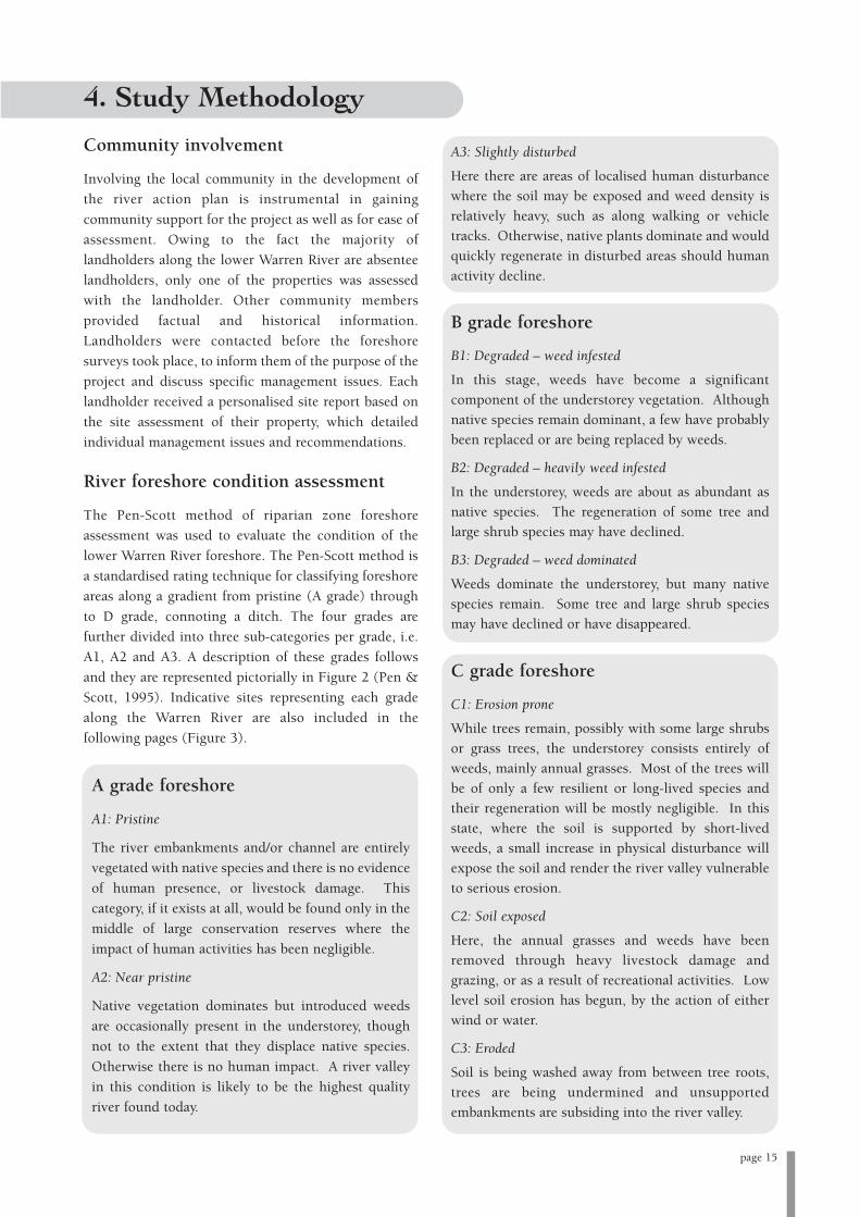
River foreshore condition assessment
The Pen-Scott method of riparian zone foreshore
assessment was used to evaluate the condition of the
lower Warren River foreshore. The Pen-Scott method is
a standardised rating technique for classifying foreshore
areas along a gradient from pristine (A grade) through
to D grade, connoting a ditch. The four grades are
further divided into three sub-categories per grade, i.e.
A1, A2 and A3. A description of these grades follows
and they are represented pictorially in Figure 2 (Pen &
Scott, 1995). Indicative sites representing each grade
along the Warren River are also included in the
following pages (Figure 3).
A grade foreshore
A1: Pristine
The river embankments and/or channel are entirely
vegetated with native species and there is no evidence
of human presence, or livestock damage. This
category, if it exists at all, would be found only in the
middle of large conservation reserves where the
impact of human activities has been negligible.
A2: Near pristine
Native vegetation dominates but introduced weeds
are occasionally present in the understorey, though
not to the extent that they displace native species.
Otherwise there is no human impact. A river valley
in this condition is likely to be the highest quality
river found today.
A3: Slightly disturbed
Here there are areas of localised human disturbance
where the soil may be exposed and weed density is
relatively heavy, such as along walking or vehicle
tracks. Otherwise, native plants dominate and would
quickly regenerate in disturbed areas should human
activity decline.
B grade foreshore
B1: Degraded – weed infested
In this stage, weeds have become a significant
component of the understorey vegetation. Although
native species remain dominant, a few have probably
been replaced or are being replaced by weeds.
B2: Degraded – heavily weed infested
In the understorey, weeds are about as abundant as
native species. The regeneration of some tree and
large shrub species may have declined.
B3: Degraded – weed dominated
Weeds dominate the understorey, but many native
species remain. Some tree and large shrub species
may have declined or have disappeared.
C grade foreshore
C1: Erosion prone
While trees remain, possibly with some large shrubs
or grass trees, the understorey consists entirely of
weeds, mainly annual grasses. Most of the trees will
be of only a few resilient or long-lived species and
their regeneration will be mostly negligible. In this
state, where the soil is supported by short-lived
weeds, a small increase in physical disturbance will
expose the soil and render the river valley vulnerable
to serious erosion.
C2: Soil exposed
Here, the annual grasses and weeds have been
removed through heavy livestock damage and
grazing, or as a result of recreational activities. Low
level soil erosion has begun, by the action of either
wind or water.
C3: Eroded
Soil is being washed away from between tree roots,
trees are being undermined and unsupported
embankments are subsiding into the river valley.
page 15
4. Study Methodology

page 16
D grade foreshore
D1: Ditch – eroding
Fringing vegetation no longer acts to control erosion.
Some trees and shrubs remain and act to retard
erosion in certain spots, but all are doomed to be
undermined eventually.
D2: Ditch – freely eroding
No significant fringing vegetation remains and
erosion is completely out of control. Undermined
and subsided embankments are common, as are large
sediment plumes along the river channel.
D3: Drain- weed dominated
The highly eroded river valley has been fenced off
enabling colonisation by perennial weeds. The river
has become a simple drain, similar if not identical to
the typical major urban drain.
Figure 2: The four grades of river foreshore condition: A (pristine) to D (ditch) (after Pen & Scott, 1995)

page 17
Figure 3: Foreshore condition of the lower Warren River (photos- Jenni Munro)
A grade section
B grade section
C grade section
Natural bank cutting exposing underlying root systems
The lower Warren River area is varied in terms of
landforms, soil types, past and current land use and
livestock access. As such, there is a range of
management issues pertinent to the area. These issues
are presented below.
Loss of native riparian vegetation
Clearing of native riparian vegetation is not a major
issue for the lower Warren River, as the majority of the
river is within the D’Entrecasteaux National Park.
Clearing is significant however in the wider Warren
catchment, with predominantly heavily cleared areas
located in the upper catchment. Clearing within the
catchment is estimated at 35%, as previously noted.
However, as the majority of the lower Warren River
assessed passes through State Forest and
D’Entrecasteaux National Park, the overall quality,
quantity and diversity of riparian vegetation is
extremely high and of excellent condition. The species
composition changes as the river flows from the start of
the survey to the mouth. Ecological disturbances arising
from official fire management practices would also
contribute to modifying the ecology and diversity of the
area, affecting vegetation structure and water chemistry
and quality within the lower Warren zone.
The emergent and terrestrial vegetation along the
waterway banks essentially defines the riparian zone.
The riparian zone serves several important ecological
functions (CENRM 2004; Pen 1997; WRC 2000f):
• Woody debris provides both terrestrial and in-stream
habitat. Riparian zones provide habitat for aquatic
animals and food for native water birds and
mammals;
• Acts as a corridor for fauna movements;
• Source of allochthonous (outside of stream) energy;
• Serves in bank stabilisation and aids in dissipating
water velocity. The root systems of riparian
vegetation increase and reinforce soil cohesion and
provide matting to protect the soil from being
transported downstream;
• Overhanging vegetation provides shade, influencing
light penetration, which in turn lowers the water
temperature. This action is beneficial in that high
water temperatures act to decrease the level of
dissolved oxygen content in waterways, which in
certain circumstances can be harmful to aquatic flora
and fauna; and
• Dense riparian vegetation acts as a buffer for
pollution, sediments and nutrients which flow down
the river, effectively stripping nutrients prior to
entering the waterway. Grasses, rushes, sedges and
shrubs are most effective at buffering.
Native vegetation also has a number of economic and
social values, including eco-tourism potential, effects on
property values, commercial products and recreation
(LWRRDC, 1996). Clearing of riparian vegetation can
have several far-reaching implications for a number of
waterway processes. Clearing has altered the
hydrological balance throughout the agricultural region
of the south west: more rain filters into the soil,
groundwater levels rise and streamflow (runoff)
increases (WRC, 2002b). Bank stabilisation and erosion
may become issues of concern, as may increased
sediment loading in the waterway. Cleared sub-
catchments upstream of major waterways are likely to
contribute to high nutrient loads downstream (CENRM
2004; WRC 2002b).
Weed invasion
Several weed species of serious concern were identified
during the foreshore surveys, predominantly blackberry
Rubus sp. (both common and small leaf varieties), briar
rose Rosa rubiginosa, golden dodder Cuscuta campestris,
kangaroo apple Solanum lanciniatum and one-leaved
cape tulip Moraea flaccida. Weeds are an issue for
management as they compete with native vegetation,
spread quickly and colonise new landscapes rapidly and
with ease, preventing regeneration by native species.
Blackberry and golden dodder pose the greatest threat to
ecosystem health along the lower Warren River,
occurring as dense infestations and being widespread
along both banks for a significant proportion of the
section surveyed. Blackberry in particular acts as a
pioneer species which dominates disturbed and cleared
areas.
Erosion and siltation
Natural, dynamic bank erosion processes occur freely
on rivers and are evident along the length of the lower
Warren River, where soils are sandy. The erosion process
becomes exacerbated and cause for management
page 20
5. Management Issues

concern when supporting riparian vegetation is cleared
and banks become further destabilised, leading to
erosion and sedimentation downstream. As most of the
erosion is a natural occurrence, bank cutting along the
lower Warren River is not cause for significant concern,
apart from areas where unrestricted stock access is
compounding the erosion problem. Stock access to
riparian zones also affects bank stability, vegetation
cover and weed infestations and can enhance erosion
concerns. For much of the section assessed, bank
cutting is occurring on one side of the channel and
deposition on the other, with the actual river channel
being in a constant state of flux. Issues associated with
erosion and subsequent siltation include loss of soil
fertility, poor water quality, infilling of summer pools,
increased channel width, further loss of native riparian
vegetation, alteration of in-stream vegetation and flow
dynamics, macroinvertebrate communities and the
potential effects of reduced photosynthesis (WRC,
2000g).
Water quality
Water quality in the lower Warren River is generally
high, due in large part to the limited proportion of the
area that has been cleared and increased input of
freshwater from rainfall in the lower catchment. As
previously noted, continuous water monitoring has not
been undertaken by the Department of Environment
since the late 1970s; however, snapshot data from the
periods 1999-2001 and 2001-2003 indicate that the
Warren River has low nutrient and moderate turbidity
levels. These water quality parameters may be impacted
upon by a number of factors occurring in the Warren
catchment, most notably further clearing of riparian
vegetation, which can lead to increased erosion and
bank destabilisation, in turn causing increased
sedimentation and turbidity levels. Similarly, especially
in the agricultural upper catchment, loss of riparian
vegetation is cause for concern given that it allows free
movement of excess nutrients into the waterway,
increasing the possibility of nutrient enrichment, or
eutrophication, and algal blooms. As noted, the Warren
River catchment is one of the most dammed catchments
in Western Australia. Of interest here is the increase in
dam construction on Warren River tributaries within
the upper catchment, which will have flow-on effects on
water quality downstream.
Salinity
Stream salinity is caused in one of two ways: rising
groundwater conveying salt to the surface, known as
dryland salinity, or by the increased volumes of water
carrying dissolved salts directly to waterways. The
clearing of native, deep-rooted vegetation and
replacement with shallow-rooted annual crops and
pastures is a major cause of dryland salinity, with further
risk factors being topography (i.e. flat, poorly drained
land) and geology of the area (i.e. less permeable
materials) (DoE 2004b; WRC 2000a). Stream salinity
has steadily increased in many rivers over the last few
decades. It is estimated that salinity has affected 80% of
waterways in the south west region. Studies show that
only 44% of streams analysed in the south west are still
considered to be fresh (less than 500 mg/L Total
Dissolved Solids, or TDS) (DoE 2004b; WRC 2000e).
The Warren River is considered to be slightly
brackish(between 1,500 mg/L and 5,000 mg/L) (DoE,
2004b) whereas the only tributary to enter the lower
Warren River area surveyed, Dombakup Brook, is
recorded as being fresh (Mayer et al., 2005). It should be
noted that the Warren becomes very brackish with
salinity levels of up to 5,000 mg/L after initial winter
rains wash dryland salt into the waterway. This salinity
load is diluted as the season progresses.
The effects of salinity on the landscape are serious.
Saline water rising to the surface is harmful to both
native vegetation and crops, disrupts soil structure and
is unsuitable for stock or human consumption. In
waterways, stream salinity increases, resulting in a
change in associated ecosystem components, most
notably replacement of native riparian vegetation with
more salt-tolerant species. The effects of stream salinity
are not localised and the repercussions of rising stream
and dryland salinity may be evident for a long distance
downstream from the initial salinised area (WRC,
2000e).
Sediment and nutrient retention
Nutrients such as nitrogen and phosphorus are
naturally present in most waterways; anthropogenic
sources include fertilisers, stormwater drainage and
sewage. Problems occur when nutrient levels become
elevated, as excess sediment and nutrient loading can be
harmful to waterway health. Excess loading can be
attributed to several processes, including clearing of
page 21

riparian vegetation, which leads to altered flow and in-
stream vegetation dynamics, altered macroinvertebrate
and fish communities, altered stream processes and
infilling of natural riverine pools (WRC, 2000f). Excess
nutrients in a waterway can cause eutrophication,
leading to rapid growth of algae during optimum
conditions. Death of algae may cause deoxygenation
within the water column. A significant algal bloom of
cyanobacteria, containing the gazetted toxic species
Microcystis cf. aeruginosa, developed in 2004. Excess
sediment can act to increase turbidity, reducing light
attenuation, which in turn influences photosynthetic
rates. Infilling of riverine pools may cause the loss of
summer refugia for many aquatic fauna, and
macroinvertebrate diversity is adversely affected by
increased sedimentation levels which in turn has an
impact upon fish community structure.
Pollution
Pollutants enter waterways either from point (localised)
or diffuse (widespread) sources. Pollutants are often
lethal or highly detrimental to aquatic life. Examples of
waterway pollutants include excess nutrients, heavy
metals, pesticides and herbicides. Arsenic sediments are
known to occur in Lefroy Brook. Salt loads also
constitute pollutants. Under the right circumstances,
excess nutrient loading leads to increased growth of
phytoplankton, macroalgae and submerged
macrophytes. Algal blooms can cause deoxygenation, a
condition that often causes loss of aquatic life (WRC,
2000f).
Stock access
Stock access to the lower Warren River is of concern,
with free stock access possible along several landholder
properties. In addition, much of the area was used
historically as a cattle lease. In areas where stock access
was historically or is currently possible, riverbank
degradation is evident. No stock crossings were present.
Problems associated with unrestricted stock access to
waterways include damage to and loss of riparian
vegetation, weed invasion, erosion, destabilisation and
trampling of banks, compacted soil and poor water
quality from faecal matter. The effects of stock access
can be evident for many years after access has been
restricted, and ongoing monitoring of fenced off areas is
required to ensure that native vegetation is regenerating,
weeds do not become established and erosion is not
further exacerbated (WRC, 2000b).
Stock watering points
There were no dedicated stock watering points located
on the lower Warren River; where present, stock were
allowed free access to the river. This has had an adverse
impact on bank stability, soil compaction and riparian
vegetation in affected areas.
Landholder issues, interests andconcerns
Landholders voiced several concerns regarding the
lower Warren River, in relation to the spread of
predominantly common, but also small leaf blackberry
throughout the area. Blackberry plants have formed
serious infestations in much of the area and landholders
expressed frustration at what many consider to be a
‘source and sink’ scenario, with surrounding national
park land harbouring blackberry populations. Other
weeds of concern to landholders and government
agencies along the river include one-leaved cape tulip,
kangaroo apple, golden dodder, thistles, pennyroyal
mint and purple groundsel. With the exception of the
blackberry and golden dodder, which is present along a
significant proportion of the study area, these weeds are
not yet firmly established along the river and it is
imperative to control their spread before it escalates.
page 22

In river management, priority is given to areas in best
condition; attention is then given to areas showing
promise of recovery and lastly, to degraded areas. This
approach is cost-effective and beneficial to the entire
river ecosystem as it is much more efficient to conserve
better quality river areas than it is to restore degraded
ones. There are a number of ways in which the health
and overall integrity of river systems can be enhanced
and maintained. How much emphasis is placed on each
component is a function of the expected outcomes for
that river or reach, i.e. revegetation of the riparian zone,
improved water quality etc. Information was sourced
from a variety of publications, details of which can be
found at the end of the section. Further information on
publications relating to this section can be found in the
Greening Australia publication Bush Tracks: Shortcuts to
Vegetation Information for Natural Resource Management
(2004).
Protection and rehabilitation of nativeriparian vegetation
The riparian zone is a very important component of the
river ecosystem. Obviously, it makes sense in terms of
both finance and labour to conserve and protect existing
riparian vegetation rather than to have to revegetate
cleared areas. Limiting unnecessary access into the
riparian zone is recommended, using fencing as
required. Restricting access to the riparian zone will act
to minimise damage from disturbance and allow natural
regeneration to occur. It is important however to effect
weed control and ensure stock access is controlled as
fenced off areas are prone to weed invasion and stock
access will undermine revegetation efforts. Natural
regeneration will occur in areas where native trees and a
healthy understorey remain. One technique for aiding
natural regeneration is known as brushing, which
constitutes laying seed-bearing parts of native flora
directly onto the ground in revegetation sites, thereby
allowing seeds to fall from the plant and germinate in
the soil. This technique is appropriate for all habitats
apart from the channel zone. However, for many
stretches of river, riparian vegetation has been
irreversibly damaged or lost, replaced by bare banks or
dominated by invasive weeds. In these cases, it is
necessary to revegetate the area back to its original state.
Revegetation of an area is commonly employed to
achieve erosion control, enhance biodiversity, improve
water quality and aid in rehabilitating saline-affected
land, apart from inherent aesthetic and recreational
benefits (WRC, 1999). Rehabilitation advice varies with
each individual case and it is recommended that local
environmental agencies and groups are contacted for
advice; however some general rules apply when
attempting to rebuild the area:
• Try and get a good understanding of the river system
and determine the vegetation present before the
damage occurred;
• Attempt to treat the cause of the problem, not just
the symptoms;
• As mentioned, focus on rehabilitating or protecting
areas of better quality before more degraded areas;
and
• Weeds should be removed and replaced with native
vegetation. In some cases however, it may be
necessary to initially colonise an area with weeds to
provide stabilisation and then introduce native
species.
Site preparation is an essential precursor to revegetating
a site. Preparation of the site involves adequately
protecting the area to be revegetated, undertaking weed
control and preparing the soil surface (e.g.
ripping/mounding) prior to planting. Appropriate
planting/seeding regimes will also have an effect on the
success of revegetation. Ongoing monitoring of weeds is
an integral part of the process, as weeds are quick to
colonise disturbed habitats and compete with native
plants for nutrients and water. There are a number of
common revegetation techniques, including brushing
(as above), direct seeding, planting of seedlings, pre-
seeded matting and in certain cases, transplanting.
These are described in more detail below.
Direct seeding
Direct seeding involves the sowing of native seed onto a
prepared site. Relatively low cost, it allows for the
establishment of a wide diversity of species for less
labour investment than is involved in planting tube
stock. Direct seeding can be less reliable than other
methods due to specific germination requirements not
being met and predation of seed. A very high investment
in weed and pest control is also required. Direct seeding
is best for floodplain and upland zones but is not
recommended for embankments. On embankments, it
is necessary to use matting or scallops, due to loss of
seed from soil and water erosion.
page 23
6. Management Advice

Planting of seedlings
Planting of seedlings is appropriate for in-stream and
embankment revegetation, as well as for areas
unsuitable for direct seeding. Planting should be
restricted to local endemic species, and a 500:50:5
planting density for herb/sedges to shrubs and trees
should be followed. Planting within the channel and
along the lower embankment should be undertaken in
spring, whereas other areas are best planted in autumn.
Pre-seeded matting
This technique involves spreading seeds onto an
appropriate fibremulch and then laying the mat on-site
after germination in early winter. As this technique is
effective in both revegetation and erosion control, it is
appropriate for steep embankments. Matting usually
requires rolling for transport to the revegetation site and
hence is suitable for sedges and rushes only, unless
matting is transported to the site before seeding, in
which case any species may be used.
Transplanting
Transplanting becomes a viable revegetation option in
instances where either an appropriate donor site is
available or where engineering works require the
removal of plants that can be transplanted at a later date
to the restored site. Caution must be exercised so as not
to transfer weed propagules or soil-borne diseases such
as dieback. As a result, the process is labour intensive
and costly. Transplanting is most effective for species
with fairly shallow root systems and vegetative growth
(e.g. sedges and rushes), and should be undertaken in
winter to early spring.
Species composition
Species composition is an important part of any
revegetation scheme. Composition of vegetation varies
with topography and soil characteristics and the choice
of species to be used in revegetation should be based
upon those native species local to the area or botanic
province (local provenance). Apart from matching
revegetation species to soil type and hydrological
requirements, other factors to consider may include
commercial agriculture or floriculture considerations. A
suggested list of appropriate species is given in
Appendix 1 and further information can be obtained
from agencies and groups including Southern Forests
Landcare, DAFWA, DEC and Greening Australia (WA).
Useful references for revegetation and rehabilitation
Pen, L. (1999). Managing Our Rivers: A Guide to the
Nature and Management of the Streams of South-West
Western Australia. Water and Rivers Commission, Perth.
Water and Rivers Commission (2001b). Using Sedges
and Rushes in Revegetation of Wetland Areas in the South
West of Western Australia. Water and Rivers
Commission, River Restoration Report No. RR 8.
Water and Rivers Commission (1999). Revegetation:
Revegetating Riparian Zones in South-West Western
Australia. Water and Rivers Commission River
Restoration Report No. RR4.
Water and Rivers Commission (1997b). Native
Vegetation of Freshwater Rivers and Creeks in South
Western Australia. Water and Rivers Commission, Perth.
Weed control
Weeds are simply plant species that are able to take
advantage of certain, usually human induced,
conditions to regenerate at the expense of native flora.
Furthermore, most weed species reproduce by highly
viable seed, vegetative propagule, or both, which can
make them very difficult to eradicate. As mentioned,
follow up revegetation and monitoring is a crucial
component of any weed control program. It is important
to note that many weeds thrive on disturbance and are
favoured by fire, and some native species may act in
ways similar to weed species.
Weed invasion along the lower Warren River and within
the catchment is a problem of increasing concern. For
management purposes, weeds can be divided into three
groups: true aquatic weeds, garden escapees and annual
pasture species. It is important to correctly identify your
weed and gain an understanding of its biology.
Management of annual weeds is in many cases limited to
preliminary spraying, while removal or poisoning of
garden escapees is necessary to control their growth in
the riparian zone. Most major tree, shrub, vine, bulbous,
herb and tall grass weeds are classed as garden escapees.
As the effort required to remove them is intensive, the
emphasis should lie on prevention rather than cure of
the problem, necessitating constant vigilance to avoid
major infestations becoming established. A further
problem in the removal of some garden escapees is that
page 24

the weed species may actually be supporting bank
stability, and their removal would result in
destabilisation. This situation highlights the necessity of
always undertaking weed removal in conjunction with
revegetation or stabilisation works. True aquatic weeds
are less prevalent as major infestations but the
consequences can be far more severe.
A coordinated and integrated approach is required to
deal with invasive weed species, such as blackberry,
cape tulip, pennyroyal and golden dodder present along
the lower Warren River. Some information on weeds
designated as priority species along the lower Warren
River is given below. The weeds are classified by the
Department of Agriculture as either declared plants or
pest plants, both of which mean the species in question
is both serious and invasive, and in need of immediate
control and eradication. Declared plants are under the
APB (Agricultural Protection Board) legislation and
landholders are obligated to control the plant on their
property. Pest plants are not included in the legislation,
meaning that there is no legal obligation for the plant to
be eradicated.
Common blackberry Rubus anglocandicans
Weed of national significance4 and declared plant.
Perennial, originally introduced from both Europe and
America as a fruit crop. Spread by birds, other animals
and vegetatively. Flowers white, sometime with a pink
tinge in bud. Found intermittently but mostly in dense
infestations along the length of the lower Warren River,
although not yet in the lower reaches of the river.
Manual control is possible if spread is localised, but
larger infestations typically require chemical treatment.
Regrowth can be treated with appropriate chemicals
when plants are actively growing and before seed set;
follow up treatment is usually necessary. Biological rust
fungus is also in use; for further details contact
Southern Forests Landcare.
Small leaf blackberry Rubus ulmifolius
As above; differs from common blackberry in that
flowers are always pink. Found in dense thickets for
approximately the first 6 km of the river surveyed, in
isolated patches thereafter. Control methods are as for
common blackberry; however small leaf blackberry is
less susceptible to the biological rust fungus.
Golden dodder Cuscuta campestris spp.
Declared plant. Parasitic twining vine, grows on host
plants. Native to North America. Located as infestations
along much of the lower Warren River. Manual control
of the golden dodder is not recommended as it is highly
likely to spread the dodder further. Control involves
removing the host plant/s for 3-5 years and revegetating
with species that are not susceptible to attack by the
dodder, e.g. grass or woody species. It is also important
to control broadleaf weeds in these areas. If revegetation
of controlled areas is not possible, then chemical control
is an option although this also needs to be repeated
annually for a period of 5 years.
One-leaved Cape tulip Moraea flaccida
Declared plant. Herb, short-lived pink to orange
flowers. Native to South Africa. Located in small
patches and scattered across selected areas of the lower
Warren. Manual control difficult due to dormant corms
in the soil; dig up the soil surrounding the plants,
remove the plant and incinerate or soak with diesel.
Chemical control is recommended, although care needs
to be taken when dealing with sensitive riparian areas.
A weed wiper as opposed to sprayer is suitable in these
instances. Control will take several years and annual
follow up is crucial. Control chemically in late winter to
spring.
Briar rose Rosa rubiginosa
Shrub, native to Europe and western Asia. Spread by
seeds, mostly by birds, foxes and water.
Flowers fragrant, late spring to summer. Established
plants can be removed manually, taking care to remove
all roots. Cutting or slashing is not effective as regrowth
will occur from crowns and rootstock. Large infestations
should be ploughed deeply, after mechanical removal of
larger bushes, to bring roots to the surface for raking
and burning. Follow up with further cultivation and
pasture improvement or the planting of a crop. Dense
pasture cover and stock grazing with goats and sheep
restricts seedling establishment. Chemical control
possible.
page 25
4Signifies that the weed has been identified as causing significant environmental damage in Australia. There are twenty weeds of nationalsignificance recognised in Australia.

Kangaroo apple Solanum laciniatum
Native to eastern Australia. Shrub, yellow to orange-
yellow egg shaped berries. Sometimes confused with
similar native species (to distinguish from the weed
species, native species berries are green tinged with
purple, black when ripe). Hand pull seedlings and
young plants, grazing and mowing also provide control.
Chemical control possible while plants are actively
growing.
Pennyroyal Mentha pulegium
Native to western Asia. Perennial herb, highly aromatic
(mint). Commonly naturalised on wet flats in
agricultural areas. Flowers blue, purple, pink, spring to
autumn. The oil is toxic/dangerous to humans and dogs
and has been known to cause breathing problems in
stock. Manual control very difficult. Chemical control
possible when actively growing over summer, at the end
of flowering. Important to control upstream infestations
and recify drainage problems.
Thistle Carduus sp.
Native to Europe, Asia and North Africa. Several species
have naturalised in WA. Small growths can be
mechanically removed, before seed set. Chemical
control is also an option, provided application occurs
before flowering, during a phase of active plant growth.
As the weed species in question are located near water
systems, physical control is the preferred method of
removal, however the size of infestation and growth
habit may make this option unviable. Chemical control
should then be considered, subject to a number of
provisions. Of importance are the possible effects of the
chemical on native flora and fauna as well as on water
quality. There are a few guiding principles to follow
when using herbicides, namely:
• Always read the label and stick to the recommend
usage;
• If possible try and spray the plants when the water
table is low, as the herbicide will have a smaller
chance of contaminating the water table;
• For optimal effectiveness, ensure that the plant is
sprayed before seeds have set;
• It may be useful to mix coloured food dye into the
spray as this will allow you to monitor progress;
• Where possible and appropriate inject the herbicide
into the lower trunk to prevent runoff;
• Do not spray on windy or rainy days, as this will
decrease the effectiveness and target accuracy of the
chemical;
• Once the plant has died, remove and burn it to
prevent any seed spread; and
• If unsure contact DAFWA.
For further information on weeds and their control,
agencies and groups such as Southern Forests Landcare,
DEC and the DAFWA may be contacted.
Useful references on weeds and weed control
Brown, K. and Brooks, K. (2002). Bushland Weeds: A
Practical Guide to Their Management. Environmental
Weeds Action Network (Inc.), Greenwood, Australia.
CSIRO (2006) (online). Weedy blackberry and raspberry
species in Western Australia and strategies for their
management. Unpublished report submitted to the
Department of Agriculture, Fisheries and Forestry.
Available World Wide Web:
http://www.ento.csiro.au/weeds/blackberry/WABBManP
lan2006_draft.pdf
CRC for Australian Weed Management (2003) (online).
CRC for Australian Weed Management. Available World
Wide Web: http://www.weeds.crc.org.au
Hussey, B.M.J., Keighery, G.J., Cousens, R.D., Dodd, J.
and Lloyd, S.G. (1997). Western Weeds: A Guide to the
Weeds of Western Australia. The Plant Protection Society
of Western Australia (Inc.), Victoria Park, Western
Australia.
Moore, J. and Wheeler, J. (2002). Southern Weeds and
Their Control. Department of Agriculture, Perth.
Water and Rivers Commission (2000i). Weeds in
Waterways. Water Notes 15. Water and Rivers
Commission, Perth.
Weeds Australia (undated) (online). Weeds Australia.
Available World Wide Web: http://www.weeds.org.au.
Water quality
Any waterway in an agricultural catchment is
potentially subject to elevated nutrient levels and
increased sedimentation as a result of farming activities,
impacting on water quality. As noted, water quality
page 26

within the lower Warren River does not currently pose
a significant management issue, with salinity levels
stabilising. However, the following techniques will help
to maintain the current quality, avoiding the necessity of
management intervention at a later stage.
Management of water quality can be achieved in a
number of ways, including maintenance of vegetative
buffers and appropriate agricultural practices.
Maintaining a vegetative buffer between the waterway
and surrounding land is beneficial in that the vegetation
effectively acts as a biological filter, intercepting and
trapping nutrients and sediment before they enter the
river. Even a buffer of grass can be effective in areas
where foreshore vegetation has been lost, and aquatic
vegetation also serves in nutrient and sediment
trapping. Agricultural practices in the surrounding
catchment have a large bearing on the subsequent
amount of sediment and nutrients transported into a
waterway. Appropriate practices can reduce the amount
of soil erosion and ensure adequate vegetative buffers
are maintained. Cultivating along rather than
perpendicular to soil contours will help to reduce soil
erosion, as will fencing to keep stock away from
waterways.
A snapshot biological survey is being conducted by
Southern Forests Landcare in the lower Warren
catchment to gain a better understanding of water
quality issues. Parameters including dissolved oxygen,
pH, turbidity, salinity, total nitrogen and phosphorus,
colour, macroinvertebrates, phytoplankton, nitrates and
nitrites will be tested. This data will enable comparisons
to be made over time on the water quality of the river,
and management actions to be decided accordingly.
Useful references on water quality
Pen, L. (1999). Managing Our Rivers: A Guide to the
Nature and Management of the Streams of South-West
Western Australia. Water and Rivers Commission, Perth.
Prosser, I., Karssies, L., Ogden, R. and Hairsine, P.
(1999). Using buffers to reduce sediment and nutrient
delivery to streams. Riparian Land Management Technical
Guidelines Volume Two: On-ground Management Tools and
Techniques. Price, P. and Lovett, S. (eds.), LWRRDC,
Canberra.
Rose, B. (2002). Best Environmental Management
Practices for Environmentally Sustainable Vegetable and
Potato Production in Western Australia: A Reference
Manual. Potato Growers Association of WA, Inc., Perth.
Water and River Commission (2001b). Water Quality
and macroinvertebrates. Water Facts 2. Water and Rivers
Commission, Perth.
Stock control
Unrestricted stock access has a number of detrimental
effects, such as impeding flora regeneration and
compacting soil, increasing erosion and bank
destabilisation, transportation of weeds and grazing and
trampling of vegetation. Limiting access of stock to
waterways is an extremely important management
practice in waterway restoration and rehabilitation,
achieved by fencing of riparian zones. However the idea
of fencing is often negatively received by landholders.
Fencing off the riparian zone is contentious for a
number of reasons, mainly that the riparian zone often
represents good grazing potential, fencing is an
expensive undertaking and management of the fenced
off area will often require intensive weed control efforts.
Fencing off the riparian zone does not have to be
absolute; the quantity of land from which stock are
excluded will depend on management objectives. If the
aim of fencing is to protect high quality riparian
vegetation to maintain habitat, landscape and ecological
corridors, all stock should be excluded. However, if the
riparian zone has a history of grazing and stock
exclusion could lead to the proliferation of weeds and a
fire hazard, allowing access for seasonal grazing is
beneficial. Fences in this instance are used to control
the level of grazing so that the dominant native
vegetation is able to regenerate. Considerations when
planning fence location include the form of the river,
presence of riparian vegetation and frequent flood
levels, in addition to land tenure and cadastral
boundaries. Correct fence placement in relation to river
valleys is illustrated in Figure 4.
Rehabilitation of old or ineffective stock watering
points, which are devoid of vegetation and have
compacted soil, may include soil amelioration, such as
ripping prior to covering with matting to control
erosion, or brushing to assist regeneration. Protection of
the regenerating vegetation from predation may be
required.
page 27
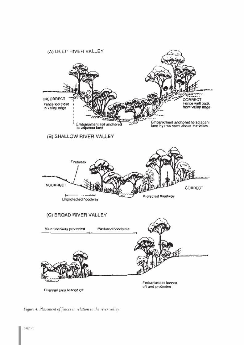
page 28
Figure 4: Placement of fences in relation to the river valley

Useful references on stock control
Pen, L. (1999). Managing Our Rivers: A Guide to the
Nature and Management of the Streams of South-West
Western Australia. Water and Rivers Commission, Perth.
Water and Rivers Commission (2000b). Livestock
Management: Construction of Livestock Crossings. Water
Note 6. Water and Rivers Commission, Perth.
Water and Rivers Commission (2000c). Livestock
Management: Fence Location and Grazing Control. Water
Note 18. Water and Rivers Commission, Perth.
Water and Rivers Commission (2000d). Livestock
Management: Watering Points and Pumps. Water Note 7.
Water and Rivers Commission, Perth.
Feral animals
Feral animals located within the lower Warren River
catchment include foxes, rabbits, cats and pigs (see also
Table 6). Invasive species cause management problems
in that they compete with native species for habitat and
resources. Feral pigs have been sighted in the nearby
area and are likely to be found in the lower Warren
River area. The presence of feral pigs is of concern,
given evidence of the damage they can inflict on
riparian areas. A large scale control program is
recommended to minimise damage from the animals to
the lower Warren River area. A coordinated approach to
feral animal control is necessary for optimal
effectiveness. Advice on feral animal control can be
obtained from Southern Forests Landcare, DEC
(formerly CALM) or DAFWA.
Erosion control
There are areas of potential concern along the lower
Warren River where natural and dynamic erosion
processes have become exacerbated. The lower Warren
has a sandy soil substrate, making the banks more prone
to erosion and slumping than heavier soils. Although
much of the river retains a dense and supportive
riparian zone, bank erosion is still significant and
intensified in areas of stock access. Revegetation of
unstable banks is the easiest way to combat erosion;
however engineering solutions involving modification
of channel flow may be necessary if revegetation proves
inadequate. If deemed necessary, site-specific advice and
relevant legal approvals should be obtained prior to
instigating any physical modification works on a river
and it is important to remember that a detailed river
geometry survey and variety of calculations are
normally required for the correct design of restorative
engineering works. As any engineering works attempted
will usually be on a larger scale, it is recommended that
landholders approach the relevant authorities (e.g.
DEC, DoW, Southern Forests Landcare, Department of
Indigenous Affairs) for assistance and notify them of
issues which are under their jurisdiction to determine.
These agencies and groups can also be approached for
general advice and expertise to aid in solving specific
problems that may be encountered.
Large woody debris also known as snags, fulfills an
important role in river ecology and is an integral and
natural part of river systems. In the past, management
practice has involved removing large woody debris from
the water in instances where it may be diverting water
flow onto the bank and subsequently causing erosion in
vulnerable areas. Preferred management practice is to
leave the greatest amount of large woody debris possible
in situ, to provide habitat for aquatic flora and fauna.
Large woody debris, instead of being removed, should
be repositioned at an angle 20°-40° to the stream bank,
which will diminish the effect on water flows and
direction while maintaining habitat. Large woody debris
can also be added to a river system to redirect flows
from unstable areas.
Rocks can also help in the stabilisation of river dynamics
and ecology. Rocks should be left in situ or in the case
of restoration be placed to help provide habitat, decrease
high flow impacts, increase oxygen levels and to
stabilise eroded zones.
Of note here is the existence of marram grass
Ammophila arenaria in the lower reaches of the Warren
River. First introduced to Western Australia in 1982,
from South Africa, marram grass is native to Europe.
The grass was planted extensively throughout the lower
Warren River area in an attempt to stabilise shifting
sand dunes, which authorities were concerned would
eventually impede the natural course of the river. The
first plantings of marram grass occurred in 1916, on the
Callcup dunes south of the river (White, 1972).
page 29
General recommendations
It is recommended that landholders along the lower Warren River consider:
• Controlling and managing weed species found on their properties;
• Prioritising the protection of their riparian land, protecting the river foreshore and restricting stock access by
fencing the riparian zone to restrict or exclude stock permanently, utilising available funding to help minimise
costs; and
• Rehabilitating their riparian zone by revegetation.
It is recommended that Southern Forests Landcare consider:
Weed control
• Encouraging an integrated community approach to weed control along the lower Warren River. Work
cooperatively with other relevant agencies and departments, e.g. DEC, DAFWA, Shire of Manjimup and
landholders to develop and implement a coordinated weed control strategy;
• Monitoring the occurrence of both common and small leaf blackberry along the length of the river. Target
common blackberry growths for biological control (rust release) over the course of a number of years, with
continued monitoring to prevent re-establishment in controlled areas along the river. Target isolated growths
for chemical control; and
• Mapping, monitoring and implementing control regimes for other weeds along the lower Warren, e.g. cape
tulip, golden dodder, kangaroo apple, briar rose, purple groundsel.
DEC and Shire managed land
• Liaising with DEC to coordinate and improve weed control and management of foreshore reserves vested with
DEC; and
• Liaising with DEC and DoW to support water quality improvement projects both locally and in the upper
catchment. Liaise with existing programs to reduce aquatic weed infestations.
Fencing and revegetation
• Actively supporting and encouraging landholders/community groups to fence off areas of the river where stock
access is possible and assisting with related funding applications; and
• Providing support and encouragement to landholders undertaking revegetation, using local provenance
seedlings.
page 30
Useful references on erosion control
Pen, L. (1999). Managing Our Rivers: A Guide to the
Nature and Management of the Streams of South-West
Western Australia. Water and Rivers Commission, Perth.
Raine, A.W. and Gardiner, J.N. (1995). Rivercare-
Guidelines for Ecologically Sustainable Management of
Rivers and Riparian Vegetation. Land and Water Research
and Development Corporation, Canberra.
Rose, B. (2002). Best Environmental Management
Practices for Environmentally Sustainable Vegetable and
Potato Production in Western Australia: A Reference
Manual. Potato Growers Association of WA, Inc., Perth.
Water and Rivers Commission (2001). Stream
Stabilisation. River Restoration Report No. RR 10. Water
and Rivers Commission, Perth.
7. River Foreshore Condition and Recommendations
for Management
Overview
The lower Warren River as represented on Figure 1 has been divided into
four sections for the purposes of reporting and surveying. The
information following should be considered along with Figure 1 and
Maps 1- 4 for spatial reference and clarity. The summarised information
includes foreshore condition ratings for the lower Warren River,
information on land use, erosion and prevalent weeds, stock access and
recommended management advice to address any issues of concern. The
information was current at the time of assessment and initial mapping of
weed species has been completed.
Southern Forests Landcare bases all information in this section upon
personal site observations, interactions with landholders and
supplementary weed presence information from the DAFWA. All
foreshore assessments took place from August to September 2006, with
the majority of sections assessed by canoe. Some landholder properties
were also assessed with the landholder. Management advice and
recommendations contained in this report are offered as an indicative
guide only. Implementation of any recommendations would be entirely
voluntary and represent a cooperative effort between interested
landholders and Southern Forests Landcare. However, while this section
contains recommendations only, implementation of the management
advice is strongly recommended.
page 31

page 32
kang
aroo
appl
e
smal
llea
fbla
ckbe
rry
com
mon
blac
kber
ryal
ong
fore
shor
e
com
mon
blac
kber
ryal
ong
fore
shor
e
smal
llea
fbla
ckbe
rry
&ka
ngar
ooap
ple
smal
llea
fbla
ckbe
rry
alon
gfo
resh
ore
smal
llea
fbla
ckbe
rry
alon
gfo
resh
ore
scat
tere
dka
ngar
ooap
ple;
scat
tere
d/d
ense
thic
kets
ofco
mm
onbl
ackb
erry
alon
gfo
resh
ore
com
mon
blac
kber
ryin
dens
eth
icke
tsal
ong
muc
hof
the
fore
shor
e;sc
atte
red
inbe
twee
n
com
mon
blac
kber
ryin
dens
eth
icke
tsal
ong
muc
hof
the
fore
shor
e;sc
atte
red
inbe
twee
n
Star
tofs
urve
y
B3
B3
3091
1189
8
1332
5
1189
7
8093
281
8930
1
(Sep
tem
ber2
006)
Low
erW
arre
nR
iver
Fore
shor
eA
sses
smen
t:M
ap1
Scal
e1:
25,0
00
00.
20.
40.
60.
81
0.1
Kilo
met
res
Exte
ntof
Map
2
Not
asse
ssed
-to
beco
mpl
eted
ata
late
rdat
e
Lower Warren River Map 1

Map 1The lower Warren River as covered by Map 1 runs through the Greater Hawke National Park, covering
approximately 4.5 km, upstream from Larkin Road Bridge to the first set of rapids. The remainder of the river as
depicted in Map 1 was not assessed in this study. The entire stretch is dominated by extensive thickets of both
common and small leaf blackberry, though common blackberry dominates. Scattered kangaroo apples and thistles
are located throughout the stretch.
Common native flora species noted along the stretch include: flooded gum Eucalyptus rudis, Warren River cedar
(wattie) Taxandria juniperina, swamp willow (wonnich) Callistachys lanceolatum, river banksia Banksia semindua,
albizia Paraserianthes lophantha, Western Australian peppermint Agonis flexuosa, karri sheoak Allocasuarina
decussata, karri hazel Trymalium floribundum, sword sedges Lepidosperma sp., rushes Juncus and Baumea sp.,
Billardiera floribunda, karri Eucalyptus diversicolor, tassleflower Leucopogon verticillatus, Astartea fasicularis, mohan
Melaleuca viminea, bracken Pteridium escalatum, swamp peppermint Taxandria linearfolia, clematis Clematis aristata,
blackbutt Eucalyptus patens, dungyn Hakea oleifolia, zamia Macrozamia reidlei and weeping grass Microlaenea
stipoides.
Summary Information
Location/lot numbers of adjacent properties National Park
Foreshore condition rating (as at Oct 2006) B3 100%
Vegetation cover & health Immediate foreshore area dominated by common and small
leaf blackberry thickets. Beyond infestations, densely
vegetated with native species, excellent vegetation health
and diversity
Land use Warren State Forest/ Greater Hawke National Park
Prioritised management actions recommended
1.Release blackberry biocontrol rust fungi into common blackberry infestations as soon as available
2.Target isolated kangaroo apples for control/ removal
Long term management actions recommended
1.Monitor effect of blackberry biocontrol rust and further spread of common and small leaf blackberry
2.Monitor emergence and spread of other weed species
page 33
Issues Comments
General foreshore Channel width approx. 20-30 m. Riparian area dominated by thickets of common and small
condition leaf blackberry which have excluded native vegetation; beyond this, a diverse and
regenerative native vegetation assemblage exists. In-stream vegetation and large woody
debris present
Fencing Entire section is unfenced. No stock present, although the area is an historical cattle lease
Erosion/bank Dynamic, natural channel erosion and deposition processes occurring along length of
stability foreshore with sandy banks in some areas exacerbating cutting and active erosion.
Historical stock access may also have contributed
Weeds Serious common and small leaf blackberry infestations dominate both banks for the
majority of the section. Weed density has excluded native vegetation growth on the
immediate foreshore areas. Isolated kangaroo apples, thistles
Other comments ~ 90 % death of blackberry growths owing to previous blackberry biocontrol rust release.
Access difficult

page 34
fruit
tree
bria
rros
e
fruit
trees
fruit
trees
fruit
trees
fruit
trees
dyin
gca
suar
inas
com
mon
blac
kber
ryfru
ittre
eat
brid
ge
B3
isol
ated
blac
kber
ryw
ithin
prop
erty
kang
aroo
appl
eal
ong
fore
shor
e
penn
yroy
alsc
atte
red
alon
gfo
resh
ore
penn
yroy
alsc
atte
red
alon
gfo
resh
ore
com
mon
blac
kber
ryin
dens
eth
icke
tsal
ong
muc
hof
fore
shor
e;sc
atte
red
inbe
twee
n
B3
B2-C
1
B2-C
1B3
Dom
baku
pBr
ook
penn
yroy
alsc
atte
red
alon
gfo
resh
ore
smal
llea
fbla
ckbe
rry
alon
gfo
resh
ore
kang
aroo
appl
eal
ong
fore
shor
e
cont
rolle
dco
mm
onbl
ackb
erry
alon
gfo
resh
ore
kang
aroo
appl
e&
wild
turn
ipal
ong
fore
shor
e
scat
tere
dth
istle
sth
roug
hout
land
hold
erpr
oper
ties
dens
eth
icke
tsof
com
mon
blac
kber
ryal
ong
muc
hof
fore
shor
e;sc
atte
red
inbe
twee
n
dens
eth
icke
tsof
com
mon
blac
kber
ryal
ong
muc
hof
fore
shor
e;sc
atte
red
inbe
twee
n
gold
endo
dder
scat
tere
dal
ong
fore
shor
ego
lden
dodd
ersc
atte
red
alon
gfo
resh
ore
kang
aroo
appl
esc
atte
red
alon
gfo
resh
ore
B3
stoc
kpr
esen
t
stoc
kpr
esen
t
Lark
inR
dBr
idge
natu
rala
nddy
nam
icba
nker
osio
n/
depo
sitio
noc
curin
gal
ong
fore
shor
e
natu
rala
nddy
nam
icba
nker
osio
n/
depo
sitio
noc
curin
gal
ong
fore
shor
e
B3
B2-C
1
3091
1339
2
3092
5471
5467
5470
5462
3092
1125
2
5472
5464
5463
1283
5
4145
1158
2
9152
1339
454
6813
394
5465
1339
491
5154
17
5473
Low
erW
arre
nR
iver
Fore
shor
eA
sses
smen
t:M
ap2
00.
250.
50.
751
0.12
5
Kilo
met
res
Sca
le1:
25,0
00
(Sep
tem
ber2
006)
Exte
ntof
Map
1
Lower Warren River Map 2

page 35
Map 2Map 2 follows the river south from Larkin Road Bridge past the first few landholder properties, covering
approximately 8.5 km. Again, the section is dominated by common blackberry thickets; golden dodder also becomes
significant throughout the stretch. The area has sandy soils; dynamic channel erosion and deposition processes are
freely occurring along the foreshore. Stock is present on two of the landholder properties, with free access to the
foreshore which is contributing in some areas to bank destabilisation. Historical stock access occurred throughout
the wider area.
Weed species in the section include common blackberry and golden dodder, which occur along much of the
foreshore, as well as kangaroo apple, fruit trees, briar rose, pennyroyal and scattered thistles/ wild turnip. Common
flora species throughout the section include: ropebush (banjine) Pimelia clavata, swamp paperbark Melaleuca
raphiophylla, flooded gum Eucalyptus rudis, Warren River cedar (wattie) Taxandria juniperina, river banksia Banksia
semindua, swamp willow (wonnich) Callistachys lanceolata, albizia Paraserianthes lophantha, Western Australian
peppermint Agonis flexuosa, karri Eucalyptus diversicolor, karri sheoak Allocasuarina decussata, karri hazel Trymalium
floribundum, sword sedges Lepidosperma sp., rushes Juncus, Baumea and Isolepis sp., dungyn Hakea oleifolia, grass
tree Xanthorrhoea preissii, Billardiera floribunda, marri Corymbia callophylla, tassleflower Leucopogon verticillatus,
Astartea fasicularis, mohan Melaleuca viminea, native maidenhair Adiantum aethiopicum, bracken Pteridium escalatum,
swamp peppermint Taxandria linearfolia, native wisteria Hardenbergia comptoniana, clematis Clematis aristata,
blackbutt Eucalyptus patens, zamia Macrozamia reidlei, weeping grass Microlaenea stipoides and kangaroo paw
Anigozanthos spp.
Summary Information
Location/lot numbers of adjacent properties National park, NL 12835, NL 5463, NL 11252, NL 5464,
NL 4145, NL 5462
Foreshore condition rating (as at Oct 2006) B3 64 %
B2-C1 36 %
Vegetation cover & health Densely vegetated with native species, excellent health.
Immediate foreshore area dominated by common
blackberry thickets. Golden dodder also present
Land use Private property, stock grazing, Greater Hawke/
D’Entrecasteaux National Park, Dombakup Nature Reserve
Issues Comments
General foreshore Channel width approx. 20 – 40 m. Riparian area dominated by thickets of common
condition blackberry which have excluded native vegetation; beyond this, a diverse and regenerative
native vegetation assemblage exists. In-stream vegetation and large woody debris present
Fencing Discrete parts of landholder foreshore fenced, but essentially unrestricted stock access
Erosion/bank Dynamic and natural channel erosion/ deposition processes occurring along length of
stability foreshore. Sandy banks and historical/ current stock access in some areas exacerbating
cutting and erosion
Weeds Serious common blackberry infestations dominate both banks for the majority of the
section. Weed density has excluded native vegetation growth on the immediate foreshore
areas. Cleared parts of landholder properties predominantly blackberry-free. Golden
dodder present along majority of foreshore area. Scattered kangaroo apples, thistles, wild
turnip and pennyroyal; isolated briar rose, fruit trees. Willow trees present in-stream
Other comments Access restricted

page 36
Prioritised management actions recommended
1. Release blackberry biocontrol rust fungi as soon as available
2. Remove willow trees from in-stream
3. Target isolated kangaroo apples for control/ removal
Long term management actions recommended
1. Monitor effect of blackberry biocontrol rust and further spread of common and small leaf blackberry
2. Monitor spread of golden dodder
3. Monitor emergence and spread of other weed species

page 37
Map 3Map 3 covers approximately 8 km, from just above the second set of landholder properties in a south westerly
direction towards the river mouth. The section includes three landholder properties; the remainder is within the
Greater Hawke and D’Entrecasteaux National Parks. The area has sandy soils. Dynamic, natural channel erosion and
deposition processes are freely occurring along the foreshore. Stock is present on two of the landholder properties,
with free access to the foreshore which is contributing to bank destabilisation in some areas. Previous stock access
in the form of coastal cattle leases occurred throughout the wider area. The section contains a disused rainbow trout
fish farm, which was in operation from 1990-1998.
The section has scattered thickets of common blackberry and golden dodder, which occur along much of the
foreshore, as well as one-leaved cape tulip, fruit trees, briar rose, pennyroyal and scattered thistles and wild turnip.
Common flora species throughout the section include: ropebush (banjine) Pimelia clavata, swamp paperbark
Melaleuca raphiophylla, Warren River cedar (wattie) Taxandria juniperina, river banksia Banksia seminuda, Western
Australian peppermint Agonis flexuosa, karri Eucalyptus diversicolor, karri sheoak Allocasuarina decussata, sword
sedges Lepidosperma sp., rushes Juncus, Baumea and Isolepis sp., dungyn Hakea oleifolia, Billardiera floribunda, marri
Corymbia callophylla, tassleflower Leucopogon verticillatus, Astartea fasicularis, mohan Melaleuca viminea, swamp
peppermint Taxandria linearfolia, native wisteria Hardenbergia comptoniana, clematis Clematis aristata, zamia
Macrozamia reidlei, weeping grass Microlaenea stipoides, kangaroo paw Anigozanthos spp., Australian bluebell Sollya
heterophylla, blue grass lily Agrostocrinum scabrum and Kunzea sp.
Summary Information
Location/lot numbers of adjacent properties National park, NL 5468, NL 5469, NL 2416, NL 2417
Foreshore condition rating (as at Oct 2006) A3-B1 12.5 %
B 60 %
B2-C1 15 %
C1-C2 12.5 %
Vegetation cover & health Aside from common blackberry thickets and golden dodder
growths, generally a very healthy and predominantly natural
assemblage of plants. Foreshore vegetation has been
removed in some parts of landholder properties
Land use Private property, stock grazing, Greater Hawke/
D’Entrecasteaux National Park
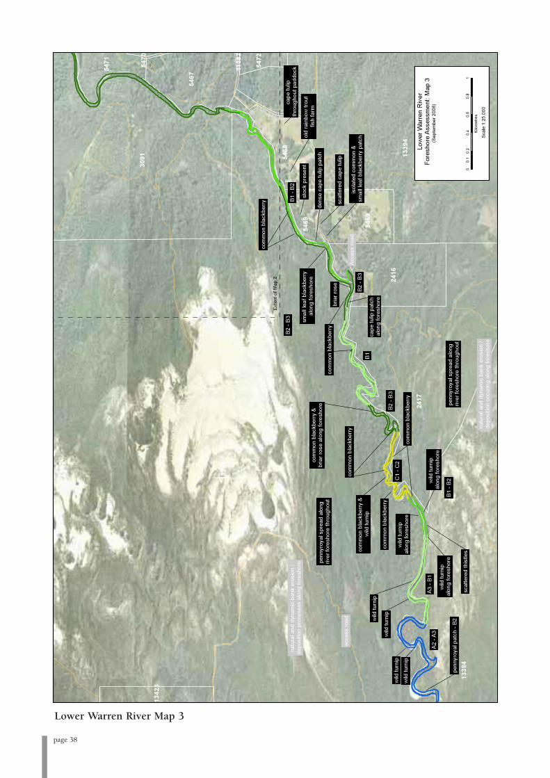
page 38
dens
eca
petu
lippa
tch
bria
rros
e
wild
turn
ip
wild
turn
ip
wild
turn
ip
wild
turn
ip
com
mon
blac
kber
ry
com
mon
blac
kber
ry
com
mon
blac
kber
ry
com
mon
blac
kber
ry
scat
tere
dth
istle
s
com
mon
blac
kber
ry
scat
tere
dca
petu
lip
penn
yroy
alpa
tch
-B2
cape
tulip
thro
ugho
utpa
ddoc
k
wild
turn
ipal
ong
fore
shor
e
wild
turn
ipal
ong
fore
shor
ew
ildtu
rnip
alon
gfo
resh
ore
cape
tulip
patc
hal
ong
fore
shor
e
smal
llea
fbla
ckbe
rry
alon
gfo
resh
ore
isol
ated
com
mon
&sm
alll
eafb
lack
berr
ypa
tch
penn
yroy
alsp
read
alon
griv
erfo
resh
ore
thro
ugho
ut
penn
yroy
alsp
read
alon
griv
erfo
resh
ore
thro
ugho
ut
com
mon
blac
kber
ry&
bria
rros
eal
ong
fore
shor
e
com
mon
blac
kber
ry&
wild
turn
ip
A2-A
3
natu
rala
nddy
nam
icba
nker
osio
n/
depo
sitio
noc
curin
gal
ong
fore
shor
e
stoc
kpr
esen
tol
dra
inbo
wtro
utfis
hfa
rm
Acce
ssro
adac
cess
road
B2-B
3
B2-B
3
B1
A3-B
1
C1
-C2
B1-B
2
B1-B
2B2
-B3
natu
rala
nddy
nam
icba
nker
osio
n/
depo
sitio
npr
oces
ses
alon
gfo
resh
ore
1339
2
1339
4
3091
2417
1339
4
2416
5467
5469
5468
5471
5469
5472
1342
3
5470
1158
2
Exte
ntof
Map
2
Low
erW
arre
nR
iver
Fore
shor
eA
sses
smen
t:M
ap3
Sca
le1:
25,0
00
(Sep
tem
ber2
006)
00.
20.
40.
60.
81
0.1
Kilo
met
res
Lower Warren River Map 3
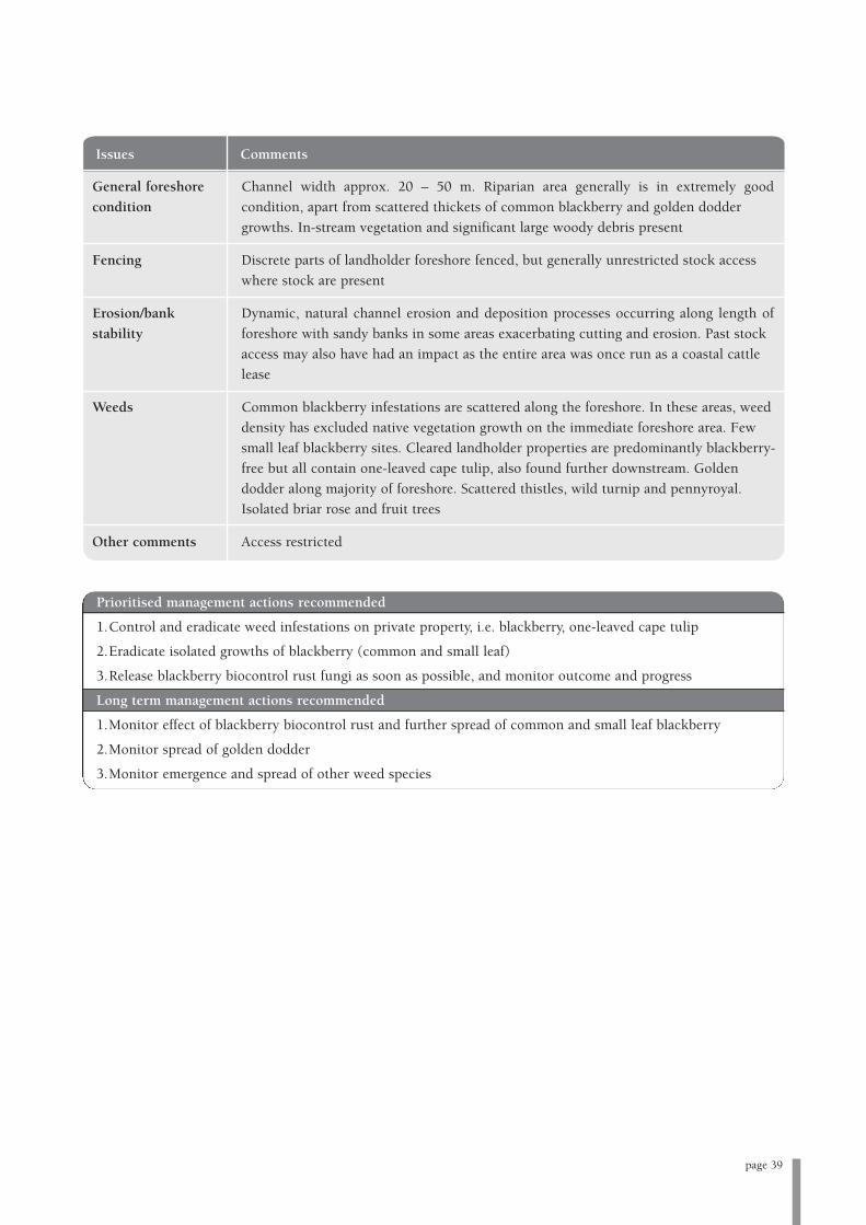
page 39
Issues Comments
General foreshore Channel width approx. 20 – 50 m. Riparian area generally is in extremely good
condition condition, apart from scattered thickets of common blackberry and golden dodder
growths. In-stream vegetation and significant large woody debris present
Fencing Discrete parts of landholder foreshore fenced, but generally unrestricted stock access
where stock are present
Erosion/bank Dynamic, natural channel erosion and deposition processes occurring along length of
stability foreshore with sandy banks in some areas exacerbating cutting and erosion. Past stock
access may also have had an impact as the entire area was once run as a coastal cattle
lease
Weeds Common blackberry infestations are scattered along the foreshore. In these areas, weed
density has excluded native vegetation growth on the immediate foreshore area. Few
small leaf blackberry sites. Cleared landholder properties are predominantly blackberry-
free but all contain one-leaved cape tulip, also found further downstream. Golden
dodder along majority of foreshore. Scattered thistles, wild turnip and pennyroyal.
Isolated briar rose and fruit trees
Other comments Access restricted
Prioritised management actions recommended
1.Control and eradicate weed infestations on private property, i.e. blackberry, one-leaved cape tulip
2.Eradicate isolated growths of blackberry (common and small leaf)
3.Release blackberry biocontrol rust fungi as soon as possible, and monitor outcome and progress
Long term management actions recommended
1.Monitor effect of blackberry biocontrol rust and further spread of common and small leaf blackberry
2.Monitor spread of golden dodder
3.Monitor emergence and spread of other weed species

page 40
dens
eru
shes
annu
alve
ldtg
rass
wild
turn
ip&
flick
wee
d
Typh
asp
.in
fest
atio
n
dens
eco
mm
onbl
ackb
erry
infe
stat
ion A2
-A3
A2-A
3
mar
ram
gras
son
fore
shor
efo
rlas
t~2k
m
gold
endo
dder
scat
tere
dal
ong
fore
shor
eun
til~1
.5km
from
river
mou
th
gold
endo
dder
scat
tere
dal
ong
fore
shor
eun
til~1
.5km
from
river
mou
th
acce
ssro
ad
info
rmal
cam
psite
offr
iver
-m
anag
emen
tacc
ess
only
-va
riety
ofm
inor
wee
ds-B
3
old
huts
ite-c
ape
wee
d,ki
kuyu
,pur
ple
grou
ndse
l,ge
rani
um,
mar
ram
gras
s,de
adly
nigh
tsha
de
limes
tone
cliff
s
limes
tone
cliff
&fre
shw
ater
sprin
g
natu
ral&
dyna
mic
bank
eros
ion
/de
posi
tion
occu
ring
alon
gfo
resh
ore
A2-A
3
Low
erW
arre
nR
iver
Fore
shor
eA
sses
smen
t:M
ap4
00.
20.
40.
60.
81
0.1
Kilo
met
res
Sca
le1:
25,0
00
(Sep
tem
ber2
006)
Exte
ntof
map
3
Lower Warren River Map 4
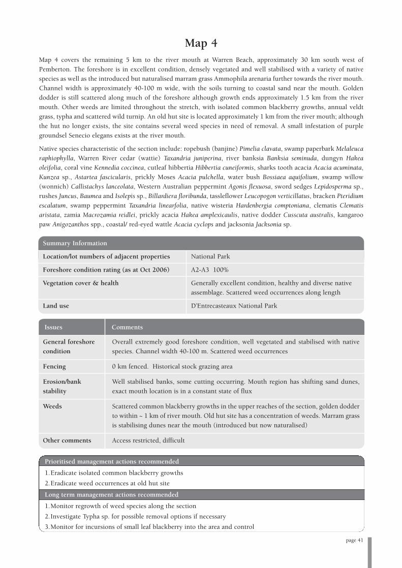
page 41
Issues Comments
General foreshore Overall extremely good foreshore condition, well vegetated and stabilised with native
condition species. Channel width 40-100 m. Scattered weed occurrences
Fencing 0 km fenced. Historical stock grazing area
Erosion/bank Well stabilised banks, some cutting occurring. Mouth region has shifting sand dunes,
stability exact mouth location is in a constant state of flux
Weeds Scattered common blackberry growths in the upper reaches of the section, golden dodder
to within ~ 1 km of river mouth. Old hut site has a concentration of weeds. Marram grass
is stabilising dunes near the mouth (introduced but now naturalised)
Other comments Access restricted, difficult
Map 4Map 4 covers the remaining 5 km to the river mouth at Warren Beach, approximately 30 km south west of
Pemberton. The foreshore is in excellent condition, densely vegetated and well stabilised with a variety of native
species as well as the introduced but naturalised marram grass Ammophila arenaria further towards the river mouth.
Channel width is approximately 40-100 m wide, with the soils turning to coastal sand near the mouth. Golden
dodder is still scattered along much of the foreshore although growth ends approximately 1.5 km from the river
mouth. Other weeds are limited throughout the stretch, with isolated common blackberry growths, annual veldt
grass, typha and scattered wild turnip. An old hut site is located approximately 1 km from the river mouth; although
the hut no longer exists, the site contains several weed species in need of removal. A small infestation of purple
groundsel Senecio elegans exists at the river mouth.
Native species characteristic of the section include: ropebush (banjine) Pimelia clavata, swamp paperbark Melaleuca
raphiophylla, Warren River cedar (wattie) Taxandria juniperina, river banksia Banksia seminuda, dungyn Hakea
oleifolia, coral vine Kennedia coccinea, cutleaf hibbertia Hibbertia cuneiformis, sharks tooth acacia Acacia acuminata,
Kunzea sp., Astartea fascicularis, prickly Moses Acacia pulchella, water bush Bossiaea aquifolium, swamp willow
(wonnich) Callistachys lanceolata, Western Australian peppermint Agonis flexuosa, sword sedges Lepidosperma sp.,
rushes Juncus, Baumea and Isolepis sp., Billardiera floribunda, tassleflower Leucopogon verticillatus, bracken Pteridium
escalatum, swamp peppermint Taxandria linearfolia, native wisteria Hardenbergia comptoniana, clematis Clematis
aristata, zamia Macrozamia reidlei, prickly acacia Hakea amplexicaulis, native dodder Cusscuta australis, kangaroo
paw Anigozanthos spp., coastal/ red-eyed wattle Acacia cyclops and jacksonia Jacksonia sp.
Summary Information
Location/lot numbers of adjacent properties National Park
Foreshore condition rating (as at Oct 2006) A2-A3 100%
Vegetation cover & health Generally excellent condition, healthy and diverse native
assemblage. Scattered weed occurrences along length
Land use D’Entrecasteaux National Park
Prioritised management actions recommended
1.Eradicate isolated common blackberry growths
2.Eradicate weed occurrences at old hut site
Long term management actions recommended
1.Monitor regrowth of weed species along the section
2.Investigate Typha sp. for possible removal options if necessary
3.Monitor for incursions of small leaf blackberry into the area and control

The foreshore assessment surveys produced the
following information for overall foreshore condition
ratings along the lower Warren River (Table 5).
Foreshore condition ratings have been averaged from
both banks of the river.
As evident from Table 5, the majority of the lower
Warren River foreshore is classed as B grade;
representing 77 % of the entire river foreshore (this
figure includes sections graded as A3-B1 and B2-C1).
The B foreshore rating implies that although the
bushland is of a generally good quality, some
degradation, weed invasion or soil disturbance is
occurring along the river. The fact that the majority of
the lower Warren River was assessed as B grade is a
positive, as B grade foreshores with weed issues are
easier to manage than foreshore areas with serious
erosion problems (i.e. C or D grade foreshores).
Decisive action by both landholders and responsible
government agencies to control weed occurrences will
be instrumental in protecting B grade stretches of
foreshore. Keeping these B grade foreshore areas in a B
grade condition, or enhancing their condition, will
require ongoing weed control measures and monitoring
for any erosion issues that may emerge. The main
management issue for these B grade sections concerns
blackberry (predominantly common, but also small
leaf) and golden dodder, which dominate much of the
foreshore. As mentioned, biocontrol rust fungus is to be
released in the area to help control blackberry
infestations. Other weed species of concern include
one-leaved cape tulip and kangaroo apple, levels of
which are still controllable. An integrated management
approach involving landholders and responsible
government agencies is preferred for dealing with these
B grade sections.
The next most common foreshore condition rating for
the lower Warren River was A grade, representing 19.2
% of the river. Grading was either A2 or A3 meaning
that there were either some weeds present but no soil
disturbance (A2), or very localised weed infestations in
areas with soil disturbance (A3). These areas, densely
vegetated with native species, were found towards the
mouth of the river within D’Entrecasteaux National
Park. Weed incidences are scattered and predominantly
localised; blackberry (as dense infestations) and golden
dodder do not occur. The main management issues for
these sections are localised weed infestations, mainly
common blackberry and the old hut site. It will be
relatively easy to control these weed occurrences and
their removal has been prioritised as a means to protect
the mouth area of the river.
Finally, a small proportion (3.8 %) of the lower Warren
was classified as C grade, indicating the presence of an
eroding and/or predominantly cleared foreshore. The
foreshore in these C grade areas has in some cases
experienced significant fringing vegetation loss,
resulting in exposed soil and bank undercutting. Much
of the C grade foreshore erosion recorded along the
river sections assessed can be attributed to sandy soils;
the bank erosion appears to be predominantly natural
and of a dynamic nature, exacerbated by high velocity
flows. Restricting stock access and restoring native
vegetation along the channel would help to improve the
ecological condition of C grade foreshores. The main
management issue for these sections concerns the
removal of stabilising foreshore vegetation and
unrestricted stock access.
page 54
8. Summary of findings
Table 5: Overall foreshore condition ratings for the lower Warren River (as at October 2006)
A Pristine to slightly disturbed 5 19.2
B Moderately degraded, soil
disturbance, weeds present 20* 77
C Eroded, soil exposed, little
foreshore vegetation 1 3.8
D Ditch/drain 0 0
Foreshore Description of Grade Total length (km) Total as a percentage of
Condition the lower Warren River surveyed
*includes sections marked A3-B and B2-C1

page 55
No sections of the lower Warren River assessed were classed as D grade. The foreshore condition ratings recorded
for each Map section of the lower Warren River are summarised in Table 6.
Table 6: Section foreshore condition ratings for the lower Warren River (as at October 2006)
Map1 0 100 0 0
Map 2 0 100 0 0
Map 3 0 87.5 12.5 0
Map 4 100 0 0 0
TOTAL % 19.2 77 3.8 0
TOTAL km 5 20 1 0
Map Section A Grade % B Grade % C Grade % D Grade %

Map
Sec
tion
Wor
ks c
omp
lete
d 2
006
Fu
ture
wor
ks
Map
1•
Rel
ease
of
blac
kber
ry b
ioco
ntr
ol r
ust
fu
ngi
in
to i
nfe
stat
ion
s •
Mon
itor
pro
gres
s of
bla
ckbe
rry
bioc
ontr
ol r
ust
fu
ngi
•C
ontr
ol k
anga
roo
appl
e
•M
onit
or f
or o
ther
wee
d in
curs
ion
•A
sses
s u
pstr
eam
of
sect
ion
•W
ork
wit
h D
EC
to
con
trol
an
d m
onit
or e
xist
ing
and
new
wee
d in
curs
ion
s
Map
2•
Fru
it t
ree
rem
oval
at
Lar
kin
Rd
Bri
dge
•M
onit
or p
rogr
ess
of b
lack
berr
y bi
ocon
trol
ru
st f
un
gi
•R
elea
se o
f bl
ackb
erry
bio
con
trol
ru
st f
un
gi i
nto
in
fest
atio
ns
•M
onit
or e
ffec
tive
nes
s of
wee
d co
ntr
ol w
orks
•W
illo
w t
ree
rem
oval
•W
ork
wit
h l
andh
olde
rs a
nd
DE
C t
o co
ntr
ol a
nd
mon
itor
exis
tin
g an
d n
ew w
eed
incu
rsio
ns
Map
3•
Rel
ease
of
blac
kber
ry b
ioco
ntr
ol r
ust
fu
ngi
in
to i
nfe
stat
ion
s•
Mon
itor
pro
gres
s of
bla
ckbe
rry
bioc
ontr
ol r
ust
fu
ngi
•C
ontr
ol o
f on
e-le
aved
cap
e tu
lip
in D
’En
trec
aste
aux
Nat
ion
al P
ark,
in
•
Mon
itor
eff
ecti
ven
ess
of w
eed
con
trol
wor
ks
con
cert
wit
h l
andh
olde
r co
ntr
ol o
n p
riva
te p
rope
rty
•W
ork
wit
h l
andh
olde
rs a
nd
DE
C t
o co
ntr
ol a
nd
mon
itor
•R
emov
al o
f is
olat
ed c
omm
on a
nd
smal
l le
af b
lack
berr
y gr
owth
sex
isti
ng
and
new
wee
d in
curs
ion
s
•A
sses
s D
omba
kup
Bro
ok
Map
4•
Rel
ease
of
blac
kber
ry b
ioco
ntr
ol r
ust
fu
ngi
in
to i
nfe
stat
ion
s•
Mon
itor
pro
gres
s of
bla
ckbe
rry
bioc
ontr
ol r
ust
fu
ngi
•C
ontr
ol o
f is
olat
ed c
omm
on b
lack
berr
y gr
owth
s•
Mon
itor
an
d if
nee
ded
foll
ow u
p co
ntr
ol o
f is
olat
ed
•C
ontr
ol o
f lo
cali
sed
wee
d gr
owth
s at
old
hu
t si
tebl
ackb
erry
gro
wth
s
•M
onit
or a
nd
if n
eede
d fo
llow
up
wee
d co
ntr
ol a
t ol
d h
ut
site
•M
onit
or f
or n
ew w
eed
incu
rsio
ns
En
tire
sec
tion
•Im
plem
ent
biol
ogic
al h
ealt
h s
nap
shot
su
rvey
dat
a co
llec
tion
•C
onti
nu
e bi
olog
ical
hea
lth
sn
apsh
ot s
urv
ey d
ata
coll
ecti
on
•(A
lso
con
duct
ed u
pstr
eam
fro
m t
he
sect
ion
of
rive
r as
sess
ed i
n t
his
•R
evis
it t
o co
llec
t da
ta i
n a
ppro
x. f
ive
year
s ti
me
acti
on p
lan
)
page 56
Tabl
e 8:
Wor
ks p
lan
for
each
riv
er s
ecti
on s
urve
yed

page 57
9. References
Brown, K. and Brooks, K. (2002). Bushland Weeds: A
Practical Guide to Their Management. Environmental
Weeds Action Network (Inc.), Greenwood, Australia.
Centre of Excellence in Natural Resource Management
(2004). Ecological Water Requirements of the Blackwood
River and Tributaries- Nannup to Hut Pool. Report
CENRM 11/04. Centre of Excellence in Natural
Resource Management, University of Western Australia,
February 2005.
Christensen, P. (1992). The Karri Forest: Its Conservation
Significance and Management. Department of
Conservation and Land Management, Perth.
Crawford, P. and Crawford, I. (2003). Contested Country:
A History of the Northcliffe Area, Western Australia.
University of Western Australia Press, Crawley.
CRC for Australian Weed Management (2003) (online).
CRC for Australian Weed Management. Available World
Wide Web: http://www.weeds.crc.org.au (accessed
16/8/2006).
CSIRO (2006) (online). Weedy Blackberry and Raspberry
Species in Western Australia and Strategies for their
Management. Unpublished report submitted to the
Department of Agriculture, Fisheries and Forestry.
Available World Wide Web:
http://www.ento.csiro.au/weeds/blackberry.
Department of Conservation and Land Management
(2002) (online). A Biodiversity Audit of Western
Australia’s 53 Biogeographical Subregions in 2002.
Available World Wide Web:
http://www.naturebase.net/science/bio_audit/index.html
(accessed 30/8/2006).
Department of Conservation and Land Management
(1987). Shannon Park and D’Entrecasteaux National Park
Management Plan 1987-1997. Department of
Conservation and Land Management, Perth.
Department of Conservation and Land Management
(undated) (online). Brockman, Beedelup and Warren
National Parks. Available World Wide Web:
http://www.calm.wa.gov.au/national_parks/previous_pa
rks_month/brockman_beedelup_warren.html (accessed
12/8/2006).
Department of Conservation and Land Management and
Conservation Commission of Western Australia (2005).
Shannon and D’Entrecasteaux National Parks Draft
Management Plan. Department of Conservation and
Land Management and Conservation Commission of
Western Australia, Perth.
Department of Environment (2004a) (online). Statewide
River Water Quality Assessment 2004. Available World
Wide Web: http://www.portal.water.wa.gov.au/portal
(Accessed 24/4/2006).
Department of Environment (2004b) (online). Stream
Salinity in South-West Western Australia-Still Rising.
Available World Wide Web:
http://portal.environment.wa.gov.au/portal/page
(accessed 3/4/2006).
Government of Western Australia (undated) (online).
Aboriginal Heritage Inquiry System. Available World
Wide Web:
http://www.dia.wa.gov.au/Heritage/SitesSurveysSearch.a
spx (accessed 13/12/2005).
Greening Australia (2004). Bush Tracks: Shortcuts to
Vegetation Information for Natural Resource Management.
Greening Australia Ltd., Yarralumla, ACT.
Hodgkin, E.P. and Clark, R. (1989). Estuaries and
Coastal Lagoons of South Western Australia: Broke Inlet
and Other Estuaries of the Shire of Manjimup. Estuarine
Study Series Number 6. Environmental Protection
Authority, Perth.
Hussey, B.M.J., Keighery, G.J., Cousens, R.D., Dodd, J.
and Lloyd, S.G. (1997). Western Weeds: A Guide to the
Weeds of Western Australia. The Plant Protection Society
of Western Australia (Inc.), Victoria Park, Western
Australia.
Land and Water Resources Research and Development
Corporation (LWRRDC) (1996). Riparian Management
Factsheets 1-7. LWRRDC, Canberra, ACT.
Mayer, X., Ruprecht, J. and Bari, M. (2005). Stream
Salinity Status and Trends in South-West Western
Australia. Salinity and Land Use Impacts Report No.
SLUI 38. Department of Environment, Perth.

Moore, J. and Wheeler, J. (2002). Southern Weeds and
Their Control. Department of Agriculture, Perth.
Morris, J. and Underwood, R. (1992). Tall Trees and Tall
Tales: Stories of Old Pemberton. Hesperian Press, Western
Australia.
Pemberton Tramway Company Pty Ltd (undated)
(online). Bridges. Available World Wide Web:
http://www.pemtram.com.au/Bridges1.htm (accessed
30/8/2006).
Pen, L. (1999). Managing Our Rivers: A Guide to the
Nature and Management of the Streams of South-West
Western Australia. Water and Rivers Commission, Perth.
Pen, L. (1997). A Systematic Overview of Environmental
Values of the Wetlands, Rivers and Estuaries of the
Busselton-Walpole Region. Waters and Rivers
Commission, Water Resource Allocation and Planning
Series, Report No. WRAP 7.
Pen, L. & Scott, M. (1995). Stream Foreshore Assessment
in Farming Areas. Blackwood Catchment Coordinating
Group, Western Australia.
Raine, A.W. and Gardiner, J.N. (1995). Rivercare-
Guidelines for Ecologically Sustainable Management of
Rivers and Riparian Vegetation. LWRRDC, Canberra.
Shire of Manjimup (1987). Shire of Manjimup Town
Planning Scheme No. 2. Shire of Manjimup, Manjimup.
Smith, M.G., Dixon, R.N.M., Boniecka, L.H., Berti, M.L.,
Sparks, T., Bari, M.A. and Platt, J. (2006). Salinity
Situation Statement: Warren River. Department of Water
Water Resource Technical Series No. WRT 32, Perth.
South West Catchments Council (2005). South West
Regional Strategy for Natural Resource Management.
South West Catchments Council, Bunbury.
State of Western Australia (2004). Warren-Blackwood
Rural Strategy. Western Australian Planning
Commission, Perth.
V. & C. Semenuik Research Group (1997). Mapping and
Classification of Wetlands from Augusta to Walpole in the
South West of Western Australia. Report prepared for the
Water and Rivers Commission, Water Resource
Technical Series No. WRT 12. Water and Rivers
Commission, Perth.
Water and Rivers Commission (2002a). Safeguarding
Aboriginal Heritage. Water Notes 30. Water and Rivers
Commission, Perth.
Water and Rivers Commission (2002b). Stream and
Catchment Hydrology. Water and Rivers Commission,
River Restoration Report No. RR19.
Water and Rivers Commission (2001a). Stream
Stabilisation. River Restoration Report No. RR 10. Water
and Rivers Commission, Perth.
Water and Rivers Commission (2001b). Using Sedges
and Rushes in Revegetation of Wetland Areas in the South
West of Western Australia. River Restoration Report No.
RR 8. Water and Rivers Commission, Perth.
Water and Rivers Commission (2001c). Water Quality
and Macroinvertebrates. Water Facts 2. Water and Rivers
Commission, Perth.
Water and Rivers Commission (2000a). Floodplain
Management. Water Facts 14. Water and Rivers
Commission, Perth.
Water and Rivers Commission (2000b). Livestock
Management: Construction of Livestock Crossings. Water
Note 6. Water and Rivers Commission, Perth.
Water and Rivers Commission (2000c). Livestock
Management: Fence Location and Grazing Control. Water
Note 18. Water and Rivers Commission, Perth.
Water and Rivers Commission (2000d). Livestock
Management: Watering Points and Pumps. Water Notes 7.
Water and Rivers Commission, Perth.
Water and Rivers Commission (2000e). Salinity. Water
Notes 15. Waters and Rivers Commission, Perth.
Water and Rivers Commission (2000f). Stream Ecology.
River Restoration Report No. RR7. Water and Rivers
Commission, Perth.
Water and Rivers Commission (2000g). Sediment in
Streams. Water Notes 17. Water and Rivers
Commission, Perth.
Water and Rivers Commission (2000h). The Value of
Large Woody Debris (Snags). Water Notes 9. Water and
Rivers Commission, Perth.
Water and Rivers Commission (2000i). Weeds in
Waterways. Water Notes 15. Water and Rivers
Commission, Perth.
Water and Rivers Commission (1999). Revegetation:
Revegetating Riparian Zones in South-West Western
Australia. River Restoration Report No. RR4. Water and
Rivers Commission, Perth.
page 58

page 59
Water and Rivers Commission (1997). Native Vegetation
of Freshwater Rivers and Creeks in South Western
Australia. Water and Rivers Commission, Perth.
Water and Rivers Commission (1996). Historical
Association of Wetlands and Rivers in the Busselton-
Walpole Region. Water Resource Technical Series Report
WRT2. Water and Rivers Commission, Perth.
Weeds Australia (undated) (online). Weeds Australia.
Available World Wide Web: http://www.weeds.org.au
(accessed 16/8/2006).
Western Australian Herbarium, CALM (undated)
(online). Florabase. Available World Wide Web:
www.florabase.calm.wa.gov.au (accessed 19/6/2006).
Wheeler, J., Marchant, N. and Lewington, M. (2002).
Flora of the South West: Bunbury-Augusta-Denmark,
Volumes 1 and 2. Commonwealth of Australia, Australia.
White, B.J. (1972). Focus on shifting sands. Forest Focus
(8). Forest Department of Western Australia, Perth.

TREES
Botanical Name Common name Habit Notes- propagation/uses/soil
Agonis flexuosa Western Tree or shrub, to Flowers white, Jul-Dec. Sands and gravels (white
Australian 10m high or grey sand, sandy soils, laterite, limestone) with
peppermint shallow fresh water table. Coastal sand dunes,
granite outcrops, limestone areas. Direct
seed/planting autumn or spring.
Taxandria Warren River Small- medium Flowers white, much of year. Fringing plant for
juniperina cedar/wattie to 25 m creeks, lakes & swamps. Can form dense thickets.
Seed, brushing, cuttings.
Allocasuarina Karri sheoak Monoecious tree Loam soils within karri forest. Craft timber.
decussata shrub, to 15m high
Allocasuarina Sheoak Dioecious, erect. Flowers brown, May-Oct. Lateritic soils, white,
fraseriana tree, 5-15 m high, grey or yellow sand. Valuable furniture timber.
bark fibrous,
reddish-brown
Banksia ilicifolia Holly-leaved Tree or shrub, Flowers white, cream, pink, yellow, red, Mar-Jan.
banksia 0.7-10m high, Dry to damp white or grey sand soils. Consolidated
with epicormic dunes or low-lying flats.
buds.
Banksia littoralis Swamp banksia Tree to 12 m high, Flowers yellow, orange, Mar-Aug. Grey or black
with epicormic peaty sand. Low-lying, seasonally damp areas,
buds along watercourses. Fire tolerant. Grown from seed
in autumn, late winter. Good craft timber.
Banksia seminuda River banksia Tree to 20 m high Flowers yellow, brown,(sub species = red) Feb-Jun.
Slightly acidic or neutral soils. Fire sensitive. Grow
from seed.
Corymbia Marri Tree to 40 m, bark Flowers white, pink, Dec-May. Wetlands, besides
callophylla rough, tesselated drainage lines, fringing salt marshes, flats, hills,
breakaways. Grow from seed/direct seed.
Eucalyptus Bullich, bastard Tree (mallee), Flowers white, Apr-Nov. Sand, sandy loam,
megacarpa karri 2–35m high, bark limestone. Hills, near swamps & streams. Clay
smooth subsoils.
Eucalyptus Yarri/ WA Large tree to 50 m, Flowers white, cream, Nov-Feb. Gravelly soils,
patens blackbutt bark rough, sandy clay, loam. Depressions, stream banks,
longitudinally valleys. Lower slopes, well drained soil, good
furrowed. timber tree, needs dense planting, heavy culling
and form pruning to produce timber. Grow from
seed/ direct seed.
Appendix 1: Suggested list of appropriate revegetation species
This information was sourced from a variety of reference material, including the online resource Florabase, a joint
initiative of the Western Australian Herbarium and DEC, Wheeler et al. (2002) and WRC (1997) as well as from local
‘in-house’ knowledge. Further information regarding the species given below as well as other species can be found
in these and other sources.
page 60
page 61
TREES (continued)
Botanical Name Common name Habit Notes- propagation/uses/soil
Eucalyptus Flooded gum Tree to 25 m, Flowers white, Jul-Sept. Sandy or loam soils.
rudis bark rough. Wetter parts of south western WA, flats, hillsides.
Seasonally waterlogged clays on floodplains, leaf
miners attack it. Grow from seed/ direct seed,
seedlings. Plant in spring.
Melaleuca Moonah/ Tree to 10 m. Flower yellow, cream, white, Nov-Feb. Sandy soils,
priessiana paperbark swamps. Less tolerant of prolonged inundation
than M. raphiophylla. Direct seed.
Melaleuca Swamp Small to medium Flower white, cream, Aug-Mar. White or grey sand,
raphiophylla paperbark tree, to 10 m. clay soils, limestone. Saltmarshes, swamps, along
watercourses. Withstands seasonal inundation.
Direct seed, cuttings.
Paraserianthes Albizia, Cape Tree or shrub, Flowers cream, greenish yellow, Jun-Sept. Fringing
lophantha wattle to 10 m. watercourses and swamps. Grown from seed.
SHRUBS
Botanical Name Common name Habit Notes- propagation/uses/soil
Taxandria Swamp Shrub to 5 m, Flowers white, most of year. Cut flower trade.
linearfolia peppermint/rosa spread to ~3 m, Fringes swamps & watercourses-stream stabiliser.
or coarse tea tree Direct seed, brushing, cutting in autumn.
Agonis parviceps White/ fine leaf Medium shrub Cut flowers, commercial, stream stabiliser.
tea tree
Astartea Astartea Erect shrub to 3 m Flowers white, pink, Jan-May/Oct-Dec. Sandy
fascicurlaris high, weeping alkaline soils along watercourses, winter-wet
branches. depressions, granite outcrops. Direct seed,
brushing, cuttings in autumn.
Banksia Slender banksia Lignotuberous tree Flowers yellow, Oct-Feb. White, yellow, brown or
attenuata or shrub, 0.4–10 m pale red sand, sometimes over laterite. Sand dunes,
high, with sandplains.
epicormic buds.
Beaufortia sparsa Swamp Shrub, 1–3 m high. Flowers red, orange, Jan-Apr/Sept-Nov. Sand.
bottlebrush Swampy areas (likes winter wet peaty sands),
riverbanks. Cut flowers.
Bossiaea Water bush, Shrub or tree, Understorey to karri- marri Flowers orange, yellow,
aquifolium netic 0.6-8 m high. red, brown, Jul-Nov. Clay loam, laterite, granite.
Legume.
Brachysema Dark pea Low spreading Flowers pea shaped, red. Stock like it. Various
celsianum shrub/ground habitats, fringing watercourses.
cover
Callistachys Wonnich/ Erect shrub/ small Flowers pea shaped, yellow-orange, Sept-Dec.
lanceolata swamp open tree to 8 m Fringes watercourses, winter wet depressions.
willow/ Thick middle storey shrub fringing watercourses.
greenbush Grows from seed.

SHRUBS (continued)
Botanical Name Common name Habit Notes- propagation/uses/soil
Hakea oleifolia Dungyn/olive- Erect shrub or tree, Flowers white, Aug-Oct. Grey or red/brown sand,
leafed hakea 2-10 m high. peaty sand, sandy loam, clay, laterite, granite, lime-
stone. Coastal sites. Ornamental, windbreak species.
Hakea varia Variable–leaved Erect or spreading Flowers white, cream, yellow, Jul-Nov. White, grey
hakea shrub to 4m, to 3m red loamy sand, clay loam, laterite. Grows in
wide. seasonally wet flats. Seed.
Homalospermum Common tea- Shrub to 4 m Forms thickets in permanently wet areas along
Firmum tree watercourses.
Hovea elliptica Tree hovea Slender, erect Flowers blue, purple, white, pea shape, Aug-Dec.
shrub or tree Laterite, gravel, clay loam, sandy loam, sandy soils.
to 3 m. Rocky slopes, granite outcrops, stabilised
sand dunes, slopes, ridges.
Leucopogon - Erect shrub to Flowers white, Jan-July. Sandy, gravelly soils.
propinquus 15 m. Coastal heath, forest.
Leucopogon Tassel flower, Bamboo-like shrub Flowers pink, red, Aug-Nov.Gravelly lateritic,
verticullaris native bamboo to 4 m. granitic soils. Often in wet areas.
Macrozamia Zamia palm Palm like plant to Flowers cones, Mar-June. Widespread. Forests,
reidlei 2 m. woodland, heathland.
Persoonia Snottygobble Erect lignotuberous Flowers yellow, Nov-Mar. Grey/yellow sand, sandy
longifolia tall shrub or tree, loam or laterite. Difficult to propagate.
to 5 m.
Podocarpus Emu bush/ wild Shrub to 3 m. Flowers cones, Aug–Jan. White or grey sand, sandy
drouynianus plum (conifer) loam or gravelly loam. Lower slopes or lowlands,
near creeks. Edible fruit with external seed.
Trymalium Karri hazel Shrub to 9 m. Flowers white, pale yellow, green July-Dec. Clay,
florabundum sandy clay, gravelly soils, laterite, granites. Near
watercourses and swamps.
Vimineria juncea Swish bush Shrub to 5 m, Flowers pea shaped, yellow, orange, red-brown, Sept-
spread 2m. Feb. Winter-wet depressions, near
lakes. Grow from seed.
Xanthorrhoea Graceful grass Tufted tree-like Flowers white, cream, Oct-Jan. Lateritic loam,
gracilis tree monocot, to 2 m. gravel, sand.
No trunk.
Xanthorrhoea Grass tree, balga Tree-like monocot Flowers cream, white, Jan-Nov. grey sand, laterite.
preissii to 5 m. Trunk Grow from seed, transplant. Extract seeds from
to over 3 m. capsules with tweezers.
Mirbelia Holly-leaved Erect prickly shrub Flowers pea shaped, pink, purple, yellow centre.
dilatata mirbelia to 3 m. Gravelly, laterite, sandy soils.
Chorileana Karri oak Shrub to 9m. Flowers yellow, white, green, drooping heads, Apr-
quercifolia Jan. Sandy & loamy soils. Rocky coast & hillsides,
granite & limestone rocks.
page 62

page 63
RUSHES, SEDGES, GROUND COVER
Botanical Name Common name Habit Notes- propagation/uses/soil
Baumea Sparse twig rush Sedge, spasely Flowers brown, Sept-Dec. Seasonally wet
arthrophylla spreading depressions, lakes. Tolerates partially sumberged
to 1 m. conditions. Grow from seed or rhizome division.
Baumea articulata Jointed twig rush Sedge to 2.5 m, Flowers spike-like, greyish brown, Sept-Dec. Lake
spreading. Often margins and watercourses. Fresh and brackish water,
forms extensive tolerates prolonged inundation (>1 m), wide tolerance
colonies. Grow from seed/rhizome division in winter.
Baumea juncea Bare twig rush Sedge to 2 m, Flowers spike-like, brown, grey, Oct-Mar. Dark grey
creeping under- sand, waterlogged soils along rivers and winter- wet
ground stems. depressions. Tolerates seasonal water fluctuations
Often forms up to 0.5 m, fresh-brackish- seasonally saline water.
extensive colonies. Rhizome transplantation, in-vitro culture of seed
Smooth cylindrical embryos.
blue-green stems.
Good colonising
plant.
Baumea preissii Sedge Sedge to 2 m. Flowers purple, brown, grey, Jul-Dec. Silty sand,
Rhizomatous, waterlogged soils. Waterlogged soils bordering
robust, colonising lakes & watercourses. Rhizomatous division.
perennial.
Baumea riparia River twig rush Sedge to 1.5 m. Flower brown, Aug-Oct. Black peaty sand. Seasonal
swamps, often brackish. Seasonally inundated
areas. Rhizome division.
Baumea rubiginosa Sedge Sedge to 4 m, Flowers brown, Aug-Mar. Waterlogged soils
spread 2 m. bordering lakes & watercourses. Grow from seed,
rhizome division.
Baumea vaginalis Sheath twig rush Sedge to 2.5 m, Flowers spike-like, brown, Sept-Dec. Fresh to semi-
grows in large saline water, seasonally wet to permanaently
clumps. Circular inundated. Grows from rhizome division or tissue
stems 2-6 mm wide. culture.
Bolboschoenus Marsh club rush Sedge to 1.2 m, Flowers spikelets, golden brown, Aug-Mar. White
caldwellii forms large or grey sand, mud, saline silt, sandy clay. Seasonally
colonies. Stems damp to seasonally inundated habitat. Tolerates
bright green, seasonal water fluctuation.
triangular in Direct seed; seed germinates readily when fresh.
cross-section. Also in-vitro culture.
Grass-like tufted
plant.
Carex appressa Tall sedge Sedge to 2 m, Flowers spikelets, greenish brown, Sept-Dec.
spread 0.5 m. Seasonally inundated or shallow permanent water
Tufted, often habitat, fresh or brackish conditions. Grow from
forms large clump rhizomes in early spring.
RUSHES, SEDGES, GROUND COVER (continued)
Botanical Name Common name Habit Notes- propagation/uses/soil
Carex fascicularis Tassel sedge Sedge to 1.5 m, Flowers spikelets, green, Sept-Nov. Black peaty sand
spread 1m. Freshwater to brackish conditions along seasonally
inundated and partially waterlogged watercourses.
Rhizomatous division.
Carex tereticaulis Sedge Sedge to 0.7 m. Flowers brown, Sep-Oct. Black peaty sand.
Tufted.
Chaetanthus Bearded Densely tufted sedge Flowers spikelets, May-Nov. Sand or clay soils in
aristatus (formerly twine-rush to 0.8 m. seasonally wet depressions. Grow from tissue culture.
Leptocarpus
aristatus)
Chorizema Flame pea Climber/ground Flowers yellow, orange, July-Dec. Sandy gravelly
cordatum cover to 1.5 m. soils, clay loam. Rocky hillsides, lateritic ridges,
undulating places.
Chorizema Holly-flame pea Climber/ ground Flowers yellow, orange with pink wings, July-Dec.
ilicifolium cover to 0.5 m. Coastal limestone. Sand, sand over limestone.
Eleocharis acuta Common spike Creeping sedge to Flowers spikelet, brown, Sept- Jan. Forms dense
rush 0.7 m, tuffs arising mass in seasonally waterlogged depressions, often
along a slender partially submerged. Also fringes freshwater
rhizome. watercourses. Grow by division, in-vitro culture.
Plant in clumps for increased stability.
Gahnia trifida Coast saw-sedge Sedge to 1.5 m, Flowers yellow, brown, Aug-Oct. Grey or white
spread 1 m. sand, clay, sometimes saline. Swamps, creeks.
Hardenbergia Native wisteria Twining shrub or Flowers blue, purple, white, Jul-Oct. Sandy soils.
comptoniana climber. Coastal limestone, sandplains, dunes.
Isolepsis nodosa Knotted club Tufted rush to 1 m. Flowers spikelets, brown, Sept-Mar. Sandy soils.
rush radiating rhizomes. Coastal dunes, winter-wet depressions and fringing
watercourses. Direct seed.
Juncus kraussii Shore rush/ sea Rush. Tussock- Flowers brown, red, Oct-Jan. White or grey sand,
rush forming, to 1.5 m. clay, alluvium. Swamps, brackish estuaries, saline
Dark green stems. flats, seashores. Grow from rhizome division or
Forms extensive direct seed. Transplant while dormant (May-June).
compact clumps.
Good colonising
plant.
Juncus pallidus Pale rush Rush. Tufted plant Flowers green, Sept-Dec. Clay. Wet or seasonally
to 2 m. Good damp soils around fresh to brackish watercourses
colonising plant. and lakes. Seed viable around Jan, or rhizome
division. Plant in clumps.
Juncus pauciflorus Loose flower Rush. Tufted plant Flowers greenish brown, Sept-Dec. Permanently
rush to 1 m. damp or seasonally wet soil. Fringes fresh
watercourses. Direct seed.
Juncus Finger rush Tufted sedge to 1 m. Flowers straw-coloured, Sept-Dec. Moist or
subsecundus seasonally wet soils. Direct seed.
page 64

page 65
RUSHES, SEDGES, GROUND COVER (continued)
Botanical Name Common name Habit Notes- propagation/uses/soil
Kennedia Coral vine Twining or trailing Flowers orange, pink, red, purple, Aug-Dec. Often
coccinea shrub or climber. on sandy soils. Grow from seed.
Climber/ground
cover.
Lepidosperma Spreading Tufted sedge to 3 m, Flowers spikelets, brown, dull grey, Sept-Dec. Sands
effusum sword-sedge spread 1 m. and clay in seasonally moist or wet watercourses
(occasionally tidal). Grow from rhizome division,
tissue culture.
Lepidosperma Coastal sword- Sedge to 1.5 m, Flowers spikelets, brown, Oct-Feb. Seasonally moist
gladiatum sedge forms broad or wet sands, dry dunes. Grow from seed,
clumps. transplant.
Lepidosperma Pithy sword- Creeping sedge Flowers spikelets, brown, May-Aug. Sands/ peaty
longitudinale sedge to 2 m. Forms sands in winter-wet depressions and along
large colonies. watercourses. Rhizome transplantation, seed
propagation difficult.
Lepidosperma Angle sword- Sedge to 3 m, Flowers spikelets, brown, Aug-Mar. Black peaty
tetraquetrum sedge spread to 2.5 m. sand. Seasonally moist or wet sands along
Forms large watercourses and winter-wet depressions. Rhizome
colonies. division, tissue culture.
Leptocarpus Bearded twine- Densely tufted Flowers spikelets, May-Nov. Sand or clay soils in
aristatus rush sedge to 0.8 m. seasonally wet depressions. Grow from tissue
culture.
Leptocarpus laxus Velvet rush Tufted plant to Flowers red, spikelets, Apr-Nov. Moist to wet sand,
1.5 m. saline soils, clay, laterite. Swamps, creeks, well-
drained flats, seasonally wet sites.
Meeboldina Rhizomatous, Sandy & clayey soils. Fringing plant along swamps,
kraussii perennial, herb creeks, granite outcrops, seasonally wet sites.
(rush-like) to Rhizomatous division.
1 m high.
Forms clumps.
Microlaena Weeping grass Clumping grass. Flowers Sept-Jan. Widespread.
stipoides
Reedia spathacea Sedge Robust, tufted Flowers brown, Nov–Jan. Peaty sand. Swamps, river
perennial, grass edges.
like or herb Propagation unknown, possibly rhizome division.
(sedge), 2-3 m
high, clumps 1.5-
2 m wide.
Schoenoplectus Sharpleaf rush Erect sedge to 1 m. Flowers spikelets, Sept-Dec. Fresh, brackish or
pungens semi-saline water in swampy conditions and
standing water. Transplant rhizomes in winter, in-
vitro culture.

RUSHES, SEDGES, GROUND COVER (continued)
Botanical Name Common name Habit Notes- propagation/uses/soil
Schoenoplectus Lake club rush Erect sedge to 3 m. Flowers spikelets, brown, Nov-Mar. Fresh, brackish
Validus Forms clumps and or semi-saline water in winter-wet depressions and
at times extensive margins of watercourses. Transplant rhizomes in
colonies. winter, in-vitro culture.
Schoenus Bog rush Rush to 1 m. Flowers spikelets, brown, July-Dec. Seasonally wet
subfascicularis Several other depressions, fringing swamps and estuaries.
suitable varieties Produces very little viable seed. Grow from rhizome
exist. division.
page 66

page 67
Appendix 2: Useful contracts
Contact Location Contact details
Southern Forests Landcare Manjimup Ph. (08) 9771 8180
Fax. (08) 9771 8108
E-mail: [email protected]
Ribbons of Blue- Andy Russell Warren region Ph. (08) 9776 1559 or 9771 8180
E-mail: [email protected]
Manjimup LCDC/ Warren Manjimup As above for Southern Forests Landcare
Catchments Council
DAFWA (inc. Biosecurity) Manjimup Ph. (08) 9777 0000
Fax. (08) 9777 0001
Web: www.agric.wa.gov.au
D’Entrecasteaux Coalition Pemberton Contact person- Andy Russell
Ph. (08) 9776 1559
E-mail: [email protected]
Department of Environment and Donnelly District Ph. (08) 9771 7988
Conservation (DEC) Manjimup Fax. (08) 9771 2677
Web: www.dec.wa.gov.au
Department of Environment and Bunbury Ph. (08) 9726 4111
Conservation Fax. (08) 9726 4100
Web: www.dec.wa.gov.au
Department of Fisheries Bunbury Ph. (08) 97 212 688
Fax. (08) 97 911 862
Web: www.fish.wa.gov.au
Department of Indigenous Affairs Albany Ph. (08) 9842 3000
Fax. (08) 9842 3517
Web: www.dia.wa.gov.au
Department of Water Manjimup Ph. (08) 9771 1878
Fax. (08) 9771 8108
Web: www.water.wa.gov.au
Land for Wildlife- Julia Boniface Nannup Ph. (08) 9756 1465
Fax. (08) 9756 1242
Web: www.dec.wa.gov.au/landforwildlife.com
Manjimup Weed Action Group Manjimup Ph. (08) 9771 7988
Fax. (08) 9771 2677
Shire of Manjimup Manjimup Ph. (08) 9771 7777
Fax. (08) 9771 7771
Web: www.manjimup.wa.gov.au
SWCC Bunbury Ph. (08) 9780 6193
Fax. (08) 9780 6198
Web: www.swcatchmentscouncil.com.au
Warren Environment Group Pemberton Contact person- Andy Russell
Ph. (08) 9776 1559
E-mail: [email protected]

Appendix 3: Bird species of the lower Warren River area
The following table lists some of the many bird species present in the lower Warren River area. The birds listed below
are those that have been previously recorded (Hodgkin & Clark,, 1989) or observed by local ornithologist Dr Mees.
Common name Scientific name Common name Scientific name
Australian kestrel Falco cenchroides Port Lincoln parrot Barnardius zonarius
Australian little falcon Falco longipennis Purple-crowned lorikeet Glossopsitta
porphyrocephala
Australian little grebe Podiceps novaehollandiae Purple swamphen Porphyrio porphyrio
Australian magpie Gymnorhina tibicen Quail Coturnix sp.
Australian raven Corvus coronoides Red wattle bird Anthochaera carunculata
Australian shelduck Tarnorna tadornoides Red wattlebird Anthochaera carunculata
Australian white ibis Threskiornis moluccus Red-capped parrot Purpureicephalus spurius
Black swan Cygnus atratus Red-capped plover Charadrius ruficapillus
Black-capped sitella Neositta pileata Red-eared firetail finch Emblema oculatum
Black-faced cuckoo Coracina novaehollandiae Red-tailed black cockatoo Calyptorhynchus
shrike magnificus
Brown falcon Falco berigora Red-winged wren Malarus elegans
Brown goshawk Accipiter fasciatus Richard’s pipit Anthus novaeseelandiae
Brown honeyeater Lichmera indistincta Sacred kingfisher Halcyon sancta
Brush wattle bird Anthochaera chrysoptera Scarlet robin Petroica multicolor
Caspian tern Hydroprogne caspia Shining bronze cuckoo Chrysococcyx lucidus
Collared sparrowhawk Accipiter cirrhocephalus Silver gull Larus novaehollandiae
Common bronzewing Phaps chalcoptera Silvereye Zosterops lateralis
Crested tern Sterna bergii Southern boobook Ninox novaeseelandiae
Dusky woodswallow Artamus cyanopterus Splendid fairy-wren Malurus splendens
Emu Dromaius novaehollandiae Spotted scrub-wren Sericornis maculatus
Eurasian coot Fulica atra Square-tailed kite Lophoictinia isura
Fan-tailed cuckoo Cacomantis flabelliformis Straw-necked ibis Threskiornis spinicollis
Golden whistler Pachycephala pectoralis Striated pardalote Pardalotus striatus
Great cormorant Phalacrocorax carbo Swamp harrier Circus approximans
Grey currawong Strepera versicolor Tree martin Petrochelidon nigricans
Grey fantail Rhipidura fuliginosa Wedge-tailed eagle Aquila audax
Grey shrike-thrush Colluricincla harmonica Welcome swallow Hirundo neoxena
Grey teal Anas gibberifrons Western rosella Platycercus icterotis
Inland thornbill Acanthiza apicalis Western spinebill Acanthorhynchus
superciliosus
Kestrel Falco cenchroides Western warbler Gerygone fusca
Kookaburra Dacelo novaeguineae Whistling kite Haliastur sphenurus
Little black cormorant Phalacrocorax sulcirostris White-breasted robin Eopsaltria georgiana
Little pied cormorant Phalacrocorax melanoleucos White-browed babbler Pomatostomus
superciliosus
Magpie-lark Grallina cyanoleuca White-faced heron Ardea novaehollandiae
page 68

page 61
Common name Scientific name Common name Scientific name
Maned duck Chenonetta jubata White-naped honeyeater Melithreptus lunatus
Mountain duck Tadorna tadornoides White-necked heron Ardea pacifica
Musk duck Biziura lobata Baudin’s cockatoo Calyptorhynchus baudinii
New Holland honeyeater Phylidonyris novaehollandiae Willie wagtail Rhipidura leucophrys
Pacific black duck Anas superciliosa Wood duck Chenonetta jubata
Pallid cuckoo Cuculus pallidus Yellow-rumped thornbill Acanthiza chrysorrhoa
Peregrine falcon Falco peregrinus

page 62

page 63

page 64