lower 9th ward, new orleans: recovery and...
TRANSCRIPT
Middle States Geographer, 2015, 48: 31-40
31
LOWER 9th WARD, NEW ORLEANS: RECOVERY AND REBUILDING
W. A. Lascell* and P. R. Baumann Department of Geography
State University of New York, College at Oneonta Oneonta, NY 13820
ABSTRACT: Hurricane Katrina, a Category 5 storm, struck the city of New Orleans on the morning of August 29, 2005 causing widespread destruction. Storm surges overtopped and breeched the levees meant to protect the city, flooding 80% of the city, with levels ranging from less than a foot to over 10 feet of water. The city remained flooded for over a month while the Army Corps of Engineers fixed the levees and pumped the water out of the low-lying landscape. Neighborhoods were forever changed as a painstakingly slow recovery forced long-time residents to make difficult decisions about where to live. The Lower 9th Ward residential neighborhood is probably the most extreme example of the change Katrina caused in the city of New Orleans. Using aerial photography, satellite imagery, ground data and fieldwork, this paper explores Katrina’s impact on this geographically vulnerable residential neighborhood and the issues associated with its recovery and rebuilding. Keywords: 2005 Hurricane Katrina, New Orleans, Lower 9th Ward, Destruction and Recovery, Remote Sensing INTRODUCTION
Ten years have passed since Hurricane Katrina catastrophically altered the geography of New Orleans. The event became the largest residential disaster in the United States history (Plyer, 2014). Prone to frequent flooding this below sea-level city has been filled-in and drained over the years using the engineering infrastructure of canals, levees and pumping stations to keep the land dry (Sills et al., 2008). Prior to Hurricane Katrina, the 1965 Hurricane Betsy was used as a benchmark for local residents since it caused the previous largest flooding event in the city’s history. However, it did not cause widespread damage (Germany, 2007) giving the residents of New Orleans a false sense of security when, in reality, extreme vulnerability to hurricane flooding existed mainly due to its physical geography, fragile levee infrastructure, and socio-economic conditions (Cutter and Emrich, 2008).
The city of New Orleans consists of 72 neighborhoods, segregated largely by race and income. This study focuses on the neighborhood known as the Lower 9th Ward. More specifically the study deals with the area between Florida Avenue and N. Claiborne Avenue and between Jourdan Avenue and Angela Street, hereafter referred to as the Ward (Figure 1). During Katrina the Ward suffered extensive mega flooding due to levee breaching and overtopping from storm surges coming in via the Industrial Canal and connected waterways. In recent years several other mega flooding events such as the 2004 Tsunami in northern Sumatra and Hurricane Sandy in 2012 along the New Jersey and New York coastal areas have occurred. It helps to record how such areas recover from these events in order to build a better understanding of how to handle future mega flooding events. The Ward experienced one of the worst flooding conditions (10 feet and higher) within New Orleans from Katrina and was one of the poorest neighborhoods in the city, a combination of conditions that makes the Ward an interesting area to study with respect to recovery. Using a series of high resolution satellite images with accompanying aerial photography, ground pictures and field observations this paper initially records the physical impact of Katrina on the Ward and then examines the events associated with the Ward‟s recovery process.
GEOGRAPHIC VULNERABILITY
Due to its geographic landscape the Ward is arguably the most physically and socially vulnerable
neighborhood in the city relating to this type of disaster. It lies several feet below sea level, is isolated from the rest of the city by water and transportation barriers, and has been historically impoverished and segregated. Physically it is characterized by elevations ranging from sea level to minus 14 feet (-4 m) below sea-level and naturally wet landscapes that are artificially kept dry by engineered infrastructure. Water is collected from the low-lying streets and pumped into the adjacent canals. Water is a constant enemy in the Ward and chronic flooding plagues the residents to the point of desensitizing residents to the risks posed by their geographic conditions. Following the storm’s water surges and the levee breaches, water remained stagnant for over a month in the Ward until the levees were repaired and the pumping process could start.

Hurricane: rebuilding the Lower 9th Ward
32
Figure 1: Location Map of the Lower 9th Ward. (Produced by Paul R. Baumann)
The Ward‟s isolation relates to being a basin surrounded by barriers designed to keep water out. These barriers also make it difficult for the Ward to integrate with other sections of the city. On the north side of the Ward is a levee followed by Bayou Bienvenue linked to the Main Outlet Canal. No major roads connect this area with the Ward. A levee and elevated railroad line on the east side separates the Ward from Saint Bernard Parish. One minor road and N. Claiborne Avenue cross this levee and rail line and provide the people in the Ward access to Chalmette. South of N. Claiborne Avenue is the St. Claude Avenue area and Holly Cross. Holy Cross is adjacent to the Mississippi River. No bridges cross the river here, and thus, the Ward has no access to the other side of the river. Florida Avenue, N. Claiborne Avenue and St. Claude Avenue are the only access routes westward, over the Industrial Canal levee, into the main portion of New Orleans. Florida Avenue and N. Claiborne Avenue have vertical-lift bridges and St. Claude Avenue a bascule bridge over the Industrial Canal disrupting car traffic as barges traverse the canal. During the storm the N. Claiborne Avenue Bridge was closed stranding many Ward residents.
Demographically the Ward has been home to mainly low-income, poorly-educated African Americans that made up 98.3% of the total population in 2000. Household incomes of less than $20,000 annually were reported by 50.5% of the families residing in the Ward. Almost one-third (32.4%) had no access to a vehicle in comparison to one out of every ten people in the United States as a whole, and 40% had only 9 to 12 years of schooling with no diploma (U.S. Census Bureau, 2000). It was challenging for these low-income residents to evacuate with not having vehicles and even those with vehicles lacked availability of cash to pay for gasoline (Elder et al., 2007). Homes in this neighborhood were mostly one-story, wooden Shotgun Style houses that were generational in their ownership history (Figure 2). They were generally poorly constructed and not well maintained over time, a reflection of the income situation in the Ward. Of those who were homeowners (59% owner-occupied houses), 55.5% owned their homes free and clear of a mortgage (The Data Center 2014; U.S. Census Bureau, 2000), which led to a need to protect their own homes during the storm. These one-story houses near or at ground level were no match for the flooding from Hurricane Katrina and residents were forced into attics, onto roofs, or to find refuge in neighboring buildings or boats.
In the Spike Lee documentary, When the Levees Broke (2006), residents were interviewed to identify the various reasons as why they stayed in their homes during the storm. Included in their reasons were the folk memories of Hurricane Betsy, a general belief that they could “ride out the storm,” inaccessibility to a vehicle or

Middle States Geographer, 2015, 48: 31-40
33
money to pay for gas, and a need to stay and tend to their own homes. The measuring stick to which all other flood events were compared was Hurricane Betsy (Landphair, 2007), a Category 3 storm. Hurricane Betsy caused widespread flooding and damage in the Ward similar to the devastation from Hurricane Katrina, but folk memories of “riding out the storm” created a false confidence in residents’ attitudes towards Hurricane Katrina (Elder et al., 2007). Residents had become accustomed to hurricane events and late evacuation orders most likely contributed to the lack of urgency to leave the Ward. These reasons, combined with the physical and social conditions and inadequate evacuation planning for the entire city, led to extreme vulnerability of the Ward to an event like Hurricane Katrina.
Figure 2: Single Shotgun home marked by rescue crews as being contaminated by “Toxic Flood Water" (left); Double Shotgun homes each with two separate residences (right) (Photos taken by Wendy A Lascell, 2006).
IMAGERY
For this study, four high resolution satellite data sets were used to analyze changes in the Ward between
2003 and 2014. The first three data sets were recorded by DigitalGlobe’s QuickBird satellite and the most recent data set by DigitalGlobe’s WorldView-2 satellite. These data sets with pixel resolutions ranging between 50 cm and 62 cm provided detailed, synoptic views of the Ward throughout its pre-storm, destruction and recovery stages. The earliest two data sets, taken on February 6, 2003 and September 20, 2005, revealed the Pre-Katrina landscape and conditions within days after the hurricane. The last two data sets, October 11, 2007 and January 22, 2014, were used to monitor the recovery progress. Augmenting these satellite data sets were aerial photography taken on June 6, 2006 and March 4, 2015, ground photography (2006, 2007, 2008, 2010, 2011, 2015) and a ground video (June 2011), all taken by the primary author who visited the Ward several times with student volunteers. The 2006-2007 photography provided a more detailed examination of the government progress in the demolition of h o m e s and removal of debris throughout the Ward. The 2008-2015 photography was used to detect the rebuilding progress.
PRE-KATRINA – JANUARY 2003
Figure 3 (2003 QuickBird satellite imagery) shows the Pre-Katrina conditions within the study area. The inset provides a better view of the detail level of the imagery. The Ward consisted of detached, small, single-family homes with a grid street pattern. The most common type of home was the one-story Shotgun Style house although some multistory houses existed. Small green spaces were found on many lots and mature trees lined several blocks. The levee acted as a floodwall, holding back the water from the Industrial Canal. A small, sloped grassy area was all that separated the levee wall from the residential properties. Schools, churches, and grocery stores were all in the vicinity of the neighborhood. The High School can be seen in the northwestern corner of the image, just below Florida Avenue. The building lots were generally small in area and long and narrow in shape, relating to the Shotgun Style house. The high density of houses (2,051per mi2, 778 per km2) that existed before Katrina related to the high population density (5,347 per mi2, 2,029 per km2) (U.S. Census Bureau, 2000). The inset image in Figure 3

Hurricane: rebuilding the Lower 9th Ward
34
illustrates these conditions. The shape and dimension of these lots created issues during the recovery process. Replacement homes were limited in design and function to these lots and trying to consolidate lots to handle larger activities created political and legal issues.
Figure 3: Lower 9th Ward: February 6, 2003 (DigitalGlobe QuickBird).
POST-KATRINA – SEPTEMBER 20, 2005
Hurricane Katrina made landfall on the morning of August 29, 2005 and catastrophically altered the landscape of the Ward. The eye of the hurricane past only a few miles to the east of the Ward and produced large storm surges in the Mississippi River Gulf Outlet (MRGO), a deep-draft shipping channel built by the Army Corps of Engineers in the late 1950s. These surges came up the channel and entered the Industrial Canal. At the same time they came over the MRGO south side levee into the Main Outlet Canal on the north side of the Ward. The construction of MRGO destroyed tens of thousands of acres of coastal wetlands that previously protected the Ward.
Storm surge flood waters poured into the Ward from three sources. To the northeast, water flowed in from Saint Bernard Parish through the MRGO. On the west side of the Ward, the Industrial Canal experienced two major breaches: one a block in from Florida Avenue and the second near N. Claiborne Avenue. A large barge, the ING 4727 (owned by the Ingram Barge Company), was swept down the canal and over the levee just above N. Claiborne Avenue, leveling structures beneath it. The surges were so great that buildings, which had served as dry refuges after Hurricane Betsy, were inundated. To add to the problem a month later the Ward was flooded again by Hurricane Rita.
Figure 4 shows the Ward between Hurricane Katrina and Hurricane Rita. Rita came across Louisiana on September 24, 2005, four days after the satellite image (Figure 4) was taken. The most severely damaged section of the Ward was just north of Claiborne Avenue. The Figure 4 inset image clearly shows the barge that was initially thought to have created the gap in the levee but was later determined to have been drawn through an existing hole in the floodwall and crushing a number of structures and a school bus. Due to liability issues the removal of this barge required court action. Salvage work started in February 2006 and was completed by the end of March 2006. Thus, the barge does not appear in Figure 5, an oblique aerial photograph taken on June 6, 2006.
As can be detected in Figure 4 the N. Claiborne Avenue site had been pumped dry but water remained on

Middle States Geographer, 2015, 48: 31-40
35
the north side of the Ward, near Florida Avenue, where the lowest elevations (-14 feet, -4 km) exists. Although the major breach occurred near the Industrial Canal, several other breaches existed along the Florida Avenue levee. The dark water/street patterns that run perpendicular to the Florida Avenue levee identify where the storm surges came across the Main Outlet Canal. It took over a month for the Army Corps of Engineers to repair the levees and pump out the floodwaters.
Figure 4: Lower 9th Ward: September 20, 2005 (DigitalGlobe QuickBird).
Figure 5: Oblique aerial photograph of a portion of the study area. N. Claiborne Avenue is to the left of the image, the Industrial Canal and the levee is at the top of the image. This photograph corresponds to a section of the Figure 4 inset. (Photo taken by Wendy A Lascell, 2006).

Hurricane: rebuilding the Lower 9th Ward
36
Figure 5 shows the damage near the N. Claiborne Avenue levee breach. Some houses remain on their foundations while others were destroyed by the storm surge – no major demolition of homes had occurred at this point in time. A Bring Back New Orleans Commission Executive Summary Report (2006) suggested making this area in whole or part into park space because of the high risk of future flooding. Most Ward residents strongly objected to this proposal, but outside experts worry about the high risk of future flooding in the area.
Due to the level of devastation and lack of population and services, the Ward was placed under curfew and remained at that status half a year after the disaster. Massive piles of garbage and homes ruined by toxic mold had to be removed. Standing flood water had to be purified before being pumped back into the wetlands and open water areas. Power lines and poles had to be reestablished and updated. Water and sewer lines had to be cleansed and storm drains had to be unclogged. Ironically to flush these lines meant using additional water. Cleaning up the Ward and repairing and replacing basic infrastructural services required time and other sections of the city also faced the same problems. During the day residents were allowed to look, salvage possessions, and leave. However, a few were doing extensive work gutting and repairing their damaged homes in preparation to move back. By January 2006, the widespread damages and difficulties in restoring basic utilities and city services still prevented the official reopening of the Ward to residents who wished to return to their homes.
RECOVERY-OCTOBER 11, 2007 AND JANUARY 22, 2014
Figure 6: Lower 9th Ward: October 11, 2007 (DigitalGlobe QuickBird).
By 2007 most of the debris had been cleared but city sponsored demolition of homes had not been
completed. Homes were marked for demolition if evidence existed for abandonment of the property and/or health hazards due to mold growth or rodent infestation. A controversial process preceded the demolition of homes because some former residents claimed they wanted to rebuild their homes but could not due to financial burdens and lack of public services. Eventually government-sponsored contractors demolished many of these homes by the summer of 2008 but numerous vacant, condemned, and/or abandoned houses remain throughout the Ward.
The 2007 high resolution satellite image (Figure 6) shows the streets being cleared of debris and a great number of concrete slabs on which houses and other structures had been built are exposed. Any rebuilding will require in most cases the removal and disposal of these slabs, a time consuming and costly endeavor. Hundreds of
Middle States Geographer, 2015, 48: 31-40
37
these slabs as well as paved driveways are distributed across the landscape. Many houses were not built on concrete slabs. They were constructed slightly off the bare ground by using concrete blocks as pillars. These areas are now covered with tall grass and weeds and occurred over large sections of the Ward. Overgrown vegetation is associated with abandoned lots. Some abandoned lots have been maintained by neighborhood residents and volunteers working with Common Ground Relief, a grassroots, non-profit organization born the day after Hurricane Katrina occurred. Other empty lots seen on the image were not abandoned and were being maintained by property owners. Houses can be detected but little evidence exists that any major recovery endeavor has taken place.
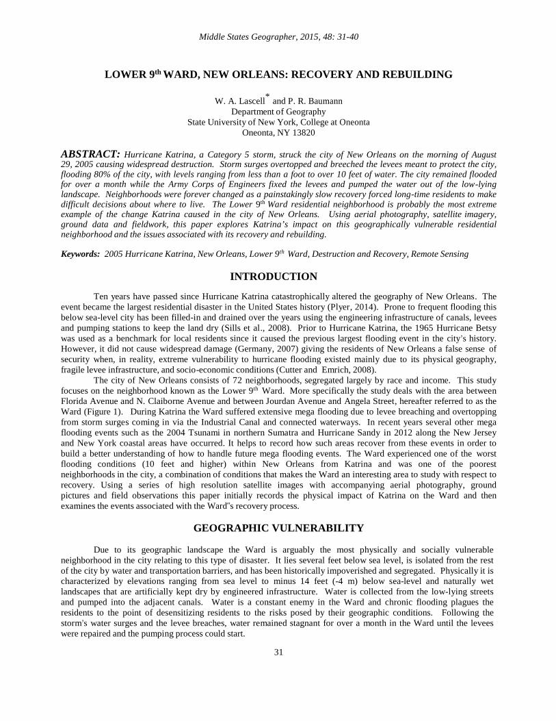
Figure 7: Residential Addresses Receiving Mail, 2005 and 2008. (Produced by Paul R. Baumann)
In order to detect housing changes in an urban landscape like the Ward it helps to have information at the city block level. A major source of such data is the decennial censuses but the 2000 and 2010 censuses are not timely enough to show the changes due to the flooding. To obtain more timely information about occupied housing at the block level in the Ward, residential delivery data from the United States Postal Service (USPS) was obtained for June 2005, two months before Katrina, and September 2008, after the Ward had been drained and cleared of debris. The USPS defines an occupied residential address as a place that actively receives mail (Plyer and Bonaguro, 2007). Figure 7 shows the drastic change before and after the flooding. Of the 221 blocks in the Ward, 111(50.2%) had no residential addresses receiving mail in 2008, after the flood conditions had been removed and mail delivery could resume. Before the flood in 2005 five blocks did not receive mail. Three of these blocks were occupied by non-residential buildings and the remaining two were parks. In 2008, 98 (44.3%) of the blocks were in the next class level ranging between 1 and 5 active residential addresses. In contrast, only six such blocks existed in 2005 and most of these blocks were small in size, and thus, held few houses. In the area between N. Claiborne Avenue and St. Claude Avenue, outside the Ward, flooding was at a lower level (less than 3 feet) and some of the land was above sea level (Figures 1). According to the U.S. Census, the Ward‟s 2010 population was 128, a significant decrease from its 2000 population of 8,501. Based on the large number of houses and lots that remain vacant and the Ward‟s low population, people living in the Ward have frequently referred to the area as being empty. The one author who has made seven field trips to the Ward between 2006 and 2016 has often experienced residents expressing its emptiness.
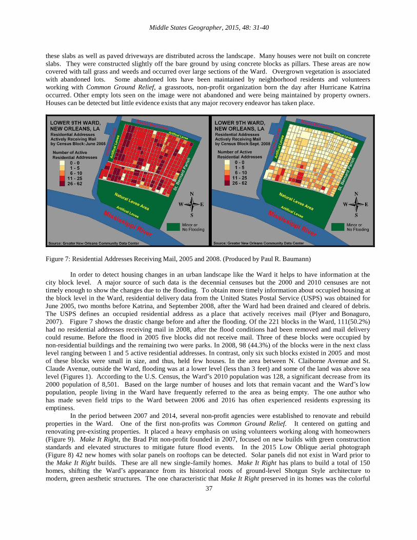
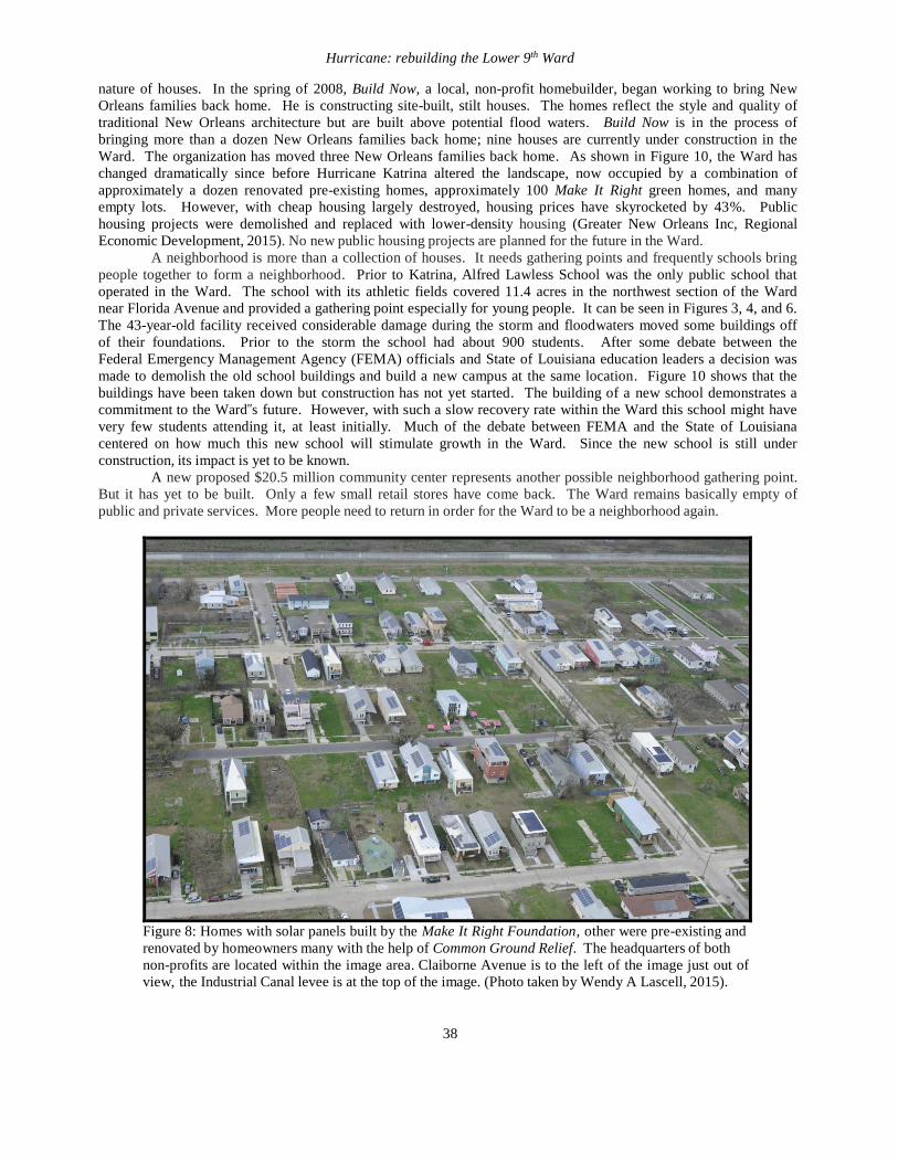
In the period between 2007 and 2014, several non-profit agencies were established to renovate and rebuild properties in the Ward. One of the first non-profits was Common Ground Relief. It centered on gutting and renovating pre-existing properties. It placed a heavy emphasis on using volunteers working along with homeowners (Figure 9). Make It Right, the Brad Pitt non-profit founded in 2007, focused on new builds with green construction standards and elevated structures to mitigate future flood events. In the 2015 Low Oblique aerial photograph (Figure 8) 42 new homes with solar panels on rooftops can be detected. Solar panels did not exist in Ward prior to the Make It Right builds. These are all new single-family homes. Make It Right has plans to build a total of 150 homes, shifting the Ward‟s appearance from its historical roots of ground-level Shotgun Style architecture to modern, green aesthetic structures. The one characteristic that Make It Right preserved in its homes was the colorful
Hurricane: rebuilding the Lower 9th Ward
38
nature of houses. In the spring of 2008, Build Now, a local, non-profit homebuilder, began working to bring New Orleans families back home. He is constructing site-built, stilt houses. The homes reflect the style and quality of traditional New Orleans architecture but are built above potential flood waters. Build Now is in the process of bringing more than a dozen New Orleans families back home; nine houses are currently under construction in the Ward. The organization has moved three New Orleans families back home. As shown in Figure 10, the Ward has changed dramatically since before Hurricane Katrina altered the landscape, now occupied by a combination of approximately a dozen renovated pre-existing homes, approximately 100 Make It Right green homes, and many empty lots. However, with cheap housing largely destroyed, housing prices have skyrocketed by 43%. Public housing projects were demolished and replaced with lower-density housing (Greater New Orleans Inc, Regional Economic Development, 2015). No new public housing projects are planned for the future in the Ward.
A neighborhood is more than a collection of houses. It needs gathering points and frequently schools bring people together to form a neighborhood. Prior to Katrina, Alfred Lawless School was the only public school that operated in the Ward. The school with its athletic fields covered 11.4 acres in the northwest section of the Ward near Florida Avenue and provided a gathering point especially for young people. It can be seen in Figures 3, 4, and 6. The 43-year-old facility received considerable damage during the storm and floodwaters moved some buildings off of their foundations. Prior to the storm the school had about 900 students. After some debate between the Federal Emergency Management Agency (FEMA) officials and State of Louisiana education leaders a decision was made to demolish the old school buildings and build a new campus at the same location. Figure 10 shows that the buildings have been taken down but construction has not yet started. The building of a new school demonstrates a commitment to the Ward‟s future. However, with such a slow recovery rate within the Ward this school might have very few students attending it, at least initially. Much of the debate between FEMA and the State of Louisiana centered on how much this new school will stimulate growth in the Ward. Since the new school is still under construction, its impact is yet to be known.
A new proposed $20.5 million community center represents another possible neighborhood gathering point. But it has yet to be built. Only a few small retail stores have come back. The Ward remains basically empty of public and private services. More people need to return in order for the Ward to be a neighborhood again.
Figure 8: Homes with solar panels built by the Make It Right Foundation, other were pre-existing and renovated by homeowners many with the help of Common Ground Relief. The headquarters of both non-profits are located within the image area. Claiborne Avenue is to the left of the image just out of view, the Industrial Canal levee is at the top of the image. (Photo taken by Wendy A Lascell, 2015).

Middle States Geographer, 2015, 48: 31-40
39
Figure 9: Common Ground Relief volunteers doing rehab work on existing home (left); Make It Right newly constructed home (right). (Photos taken by Wendy A Lascell, 2010 and 2015).
Figure 10: Lower 9th Ward: January 22, 2014 (DigitalGlobe’s WorldView-2).
CONCLUSION
More than 40 of the city’s 72 neighborhoods were flooded during Katrina, many with more than 10 feet of
water. All told, 107,379 New Orleans homes were flooded and 26,965 sustained wind damage (Plyer and Mack, 2015). Ten years after Katrina, more than half (40) of New Orleans’72 neighborhoods have recovered over 90 percent of the population they had before the levees failed. Only four neighborhoods have less than half the population they had prior to Katrina. The Ward is one of these four neighborhoods. Three of these neighborhoods had public housing sites that have been demolished to make way for new mixed–income housing with the idea of increasing the populations of these areas. Only the Ward is not scheduled for public housing. At its present growth rate it will take decades before the Ward recovers to its Pre-Katrina population and housing level. Many questions remain about the future of the Ward. How many people might be expected to resettle the area? Will the Make It Right homes continue to dominate the landscape? Will a new urban character develop or will we see a return to the

Hurricane: rebuilding the Lower 9th Ward
40
“old” Ward? Will gentrification be an issue for this historically poor, black neighborhood? The black population was ~97% prior to Katrina and now it is estimated to be ~60%, indicating that whitening has occurred (Lascell, 2015). Without better and long-term planning, rebuilding in the Ward will continue in a haphazard manner.
REFERENCES
Bring New Orleans Back Commission (2006). Urban Planning Committee: Action Plan for New Orleans, Executive Summary http://www.columbia.edu/itc/journalism/cases/katrina/city_of_new_orleans_bnobc.html (last accessed 10/3/2015). Cutter, S.L. and Emrich, C.R. (2006). Moral Hazard, Social Catastrophe: The Changing Face of Vulnerability Along the Hurricane Coasts. Annals of the Academy of Political and Social Sciences 604:102-112. Elder, K., S. Xirasagar, N. Miller, S.A. Bowen, S. Glover, and C. Piper. (2007). African Americans‟ Decisions Not to Evacuate New Orleans Before Hurricane Katrina: A Qualitative Study. Am. Journal of Public Health 97:124-129. Germany, K.B. (2007). New Orleans After the Promises: Poverty, Citizenship, and the Search for the Great Society. University of Georgia Press, Athens GA. Greater New Orleans Inc, Regional Economic Development. (2015). 10 years after Katrina, „New‟ New Orleans leaves many behind. New Orleans City Business | http://gnoinc.org/news/region-news/10-years-after-katrina- newnew-orleans-leaves-many-behind/ (last accessed 10/5/2015). Lascell, A. (2015). Is Urban Sustainability Possible in Post-Katrina New Orleans? in Urban Sustainability: Praxis & Place, Gatrell, J., Jensen, R, Patterson, M., Hoalst-Pullen, N. (eds.). Heidelberg: Springer. Landphair, J. (2007). The Forgotten People of New Orleans Community Vulnerability and the Lower Ninth Ward Journal of American History, 94 Dec 2007 837-45. Lee, S. (2006), When the Levees Broke: A Requiem in Four Acts. HBO Documentary Films and 40 Acres and a Mule Filmworks. 256 minutes Plyer, A. (2014). Facts for Features: Katrina Impact. Report. The Data Center: Independent Analysis for Informed Decisions in Southeast Louisiana. Plyer, A. and J. Bonaguro (2007). Using U.S. Postal Service Delivery Statistics to Track the Repopulation of New Orleans and the Metropolitan Area. Research Note. Greater New Orleans Community Data Center. https://gnocdc.s3.amazonaws.com/reports/GNOCDC_research_note_May07.pdf. (last accessed 03/17/2016). Plyer, A. and V. Mack (2015). Neighborhood Recovery Rates: Growth continues through 2015 in New Orleans neighborhoods. Greater New Orleans Community Data Center. http://www.datacenterresearch.org/reports_analysis /neighborhood-recovery-rates-growth-continues-through-2015-in-new-orleans-neighborhoods/ (last accessed 03/17/2016). Sills, G.L., N.D. Vroman, R.E. Wahl, and N.T. Schwanz. (2008). Overview of New Orleans Levee Failures: Lessons Learned and Their Impact on National Levee Design and Assessment. Journal of Geotechnical and Geoenvironmental Engineering 134: 556–65. The Data Center (2014). Lower Ninth Ward Statistical Area http://www.datacenterresearch.org/dataresources/ neighborhood-data/district-8/lower-ninth-ward/ (last accessed 10/4/2015). The Data Center (2005). New Orleans Area Maps. Extent of Katrina Flooding map. http://www.datacenterresearch. org/maps/ (last accessed 10/4/2015). U.S. Census Bureau. (2000 and 2010). Decennial Census. www.census.gov (last accessed 09/29/15).