loon mountain south peak beginner ski terrain...
TRANSCRIPT
1
Loon Mountain Ski Resort
South Peak Learning Center
Town of Lincoln Grafton County, NH
Scoping Report
Prepared by the
Eastern Region Winter Sports Team
July 2013
For Information, Contact: Joe Gill Eastern Region Sports team
White Mountain National Forest 300 Glen Road
Gorham, NH 03846 Phone: 603-466-2713 x221
Fax: 603-466-2856; Attn: Joe Gill [email protected]
http://www.fs.usda.gov/projects/whitemountain/landmanagementforests/projects
2
Scoping Report
for
Loon Mountain South Peak Learning Center
Summary The White Mountain National Forest (WMNF) is proposing to authorize Loon Mountain Recreation Corporation (LMRC) to construct new ski and snowboard trails and two chairlifts as part of a ski and snowboard Learning Center expansion project on Loon Mountain’s South Peak area. The proposed new Learning Center would include the construction of two fixed-grip quad chairlifts, two Magic Carpet® conveyor surface lifts and approximately 13 ski trails comprising 21 acres of new and 5 acres of existing beginner/learner terrain with associated snowmaking and snowmaking lines.
Approximately 60% of one of the chairlifts and the new trails would be located on National Forest System (NFS) lands while the lower 40% of this lift and the trails would be on private lands. About 35% of the second chairlift would be on NFS lands while the remaining 65% would be on private lands. Both Magic Carpet® lifts and the trails these surface lifts serve would be entirely on private lands. The trail Escape Route, presently used by skiers who have parked in overflow parking in the South Mountain area and are leaving the resort for the day, would remain largely separate from the learner area. In addition, LMRC would construct a 6,000 square foot base lodge, entirely on private land, near the existing overflow parking area.
The portion of the proposed Learning Center that would be on NFS lands would occur within the existing Special Use Permit (SUP) boundary area to the southwest of the Pemigewasset Base Camp area. These NFS lands are designated in the White Mountain National Forest Land and Resource Management Plan (Forest Plan) as Management Area 7.1, Alpine Ski Areas. The proposed action is consistent with the 1999 Loon Mountain Master Development Plan (MDP), as amended (Sno.engineering [now SE Group] 2000).
Background Loon Mountain Ski Resort (Loon Mountain) is located in Lincoln, New Hampshire, off Interstate 93 at Exit 32, on the western end of the scenic Kancamagus Highway (Route 112) in Grafton County, Town of Lincoln, New Hampshire (Figure 1). Loon Mountain is a four-season resort operated by LMRC primarily on National Forest System (NFS) lands on the Pemigewasset Ranger District in the White Mountain National Forest (WMNF). LMRC, a wholly-owned subsidiary of CNL Income Loon Mountain, LLC, operates on NFS lands under the authority of a

3
SUP issued by the Forest Service and administered by the White Mountain National Forest. The SUP authorizes use of 1,366 acres of NFS lands for alpine skiing areas at Loon Mountain. Loon Mountain has operated under a SUP since 1965; the current SUP was issued in 2002 and expires in 2042.
The SUP authorizes the permit holder to provide four-season, developed recreation opportunities to the public on NFS lands. While the Forest Service oversees the management of the lands and resources associated with the ski area, the improvements, including lifts, lodges, snowmaking systems, etc., are owned and operated by the permit holder. The cost of construction (and removal, when necessary) of these facilities is the responsibility of the permit holder as are all operating expenses, environmental analyses and environmental protection measures. In addition, the permit holder pays user fees to the U.S. Government; these fees are based on their business receipts. This proposal and its analysis are funded by the permit holder, irrespective of the outcome of the Responsible Official's decision.
There are approximately 370 skiable acres at the resort that encompass 61 maintained trails, seven gladed areas and seven terrain parks including a 425-foot superpipe and a mini-pipe. With the exception of the deficiencies discussed below, the trail and terrain network accommodates a range of ability levels from beginner to expert for both skiers and riders.

4

5
Purpose and Need Over the past several ski seasons, Loon Mountain has identified five primary needs for change in winter operations at its resort. This proposal addresses those needs by:
1) responding to demonstrated demand for additional beginner/learner terrain. Loon Mountain attracts a high percentage of beginner and novice skiers and demand by this user group is increasing. Ski school data for the past four seasons (between 2009/10 and 2012/13) confirms these increasing trends. During this time period:
• annual Level 1–3 (first-time beginner through novice) ski school lessons increased by 19.6% (from 5,754 to 6,879).
• total annual ski school lessons increased by 19.3% (from 8,132 to 9,700).
• approximately 56.3% of Loon Mountain’s total Ski School business was composed of first-time skiers and snowboarders.
• 77.3% of Loon Mountain’s total ski school business was Level 1-3 (first-time beginner through novice) skiers and snowboarders.
Loon Mountain’s existing terrain ability breakdown is shown in the following table:
Existing Terrain Ability Breakdown: Existing
Ability Level Acres % of Total Terrain
Beginner/Novice 58.2 15 Beginner* 8.8 2 Novice** 49.4 13
Low Int./Intermediate 195.9 51 Advanced/Expert 128.2 34 Total 382.3 100 *Includes first timer and beginner **Includes competent beginner and novice
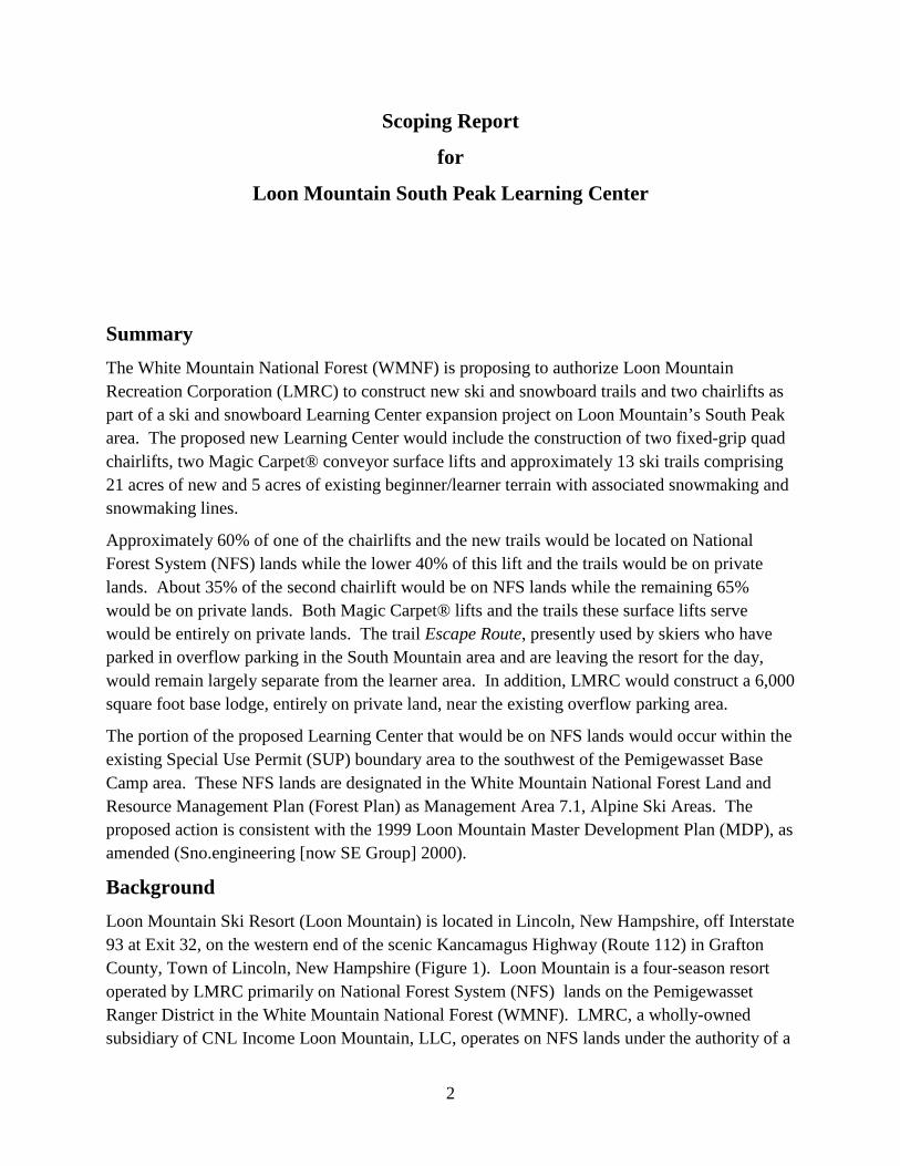
Because Loon’s beginner/learner visitation is relatively high and is increasing, the existing Learning Center, located near the Governor Adams’ Lodge base area, has notable and worsening overcrowding problems on its first-timer (0-8% slope), beginner (9-12%), and competent beginner (13-20%) terrain. At just 8.8 acres (1.7 acres of which is suitable for first-timers), this limited teaching terrain is quickly overwhelmed by users, even on moderately busy days. A photo of a typical day at the Sarsaparilla teaching and learning area is provided on the cover of this document. This overcrowding compromises both the quality of the skier/boarder experience as well as skier/boarder safety.
Furthermore, nearly half of Loon’s novice terrain (e.g., Exodus, Upper Bear Claw, Grand Junction, The Link, and Brookway) is also regularly used by more advanced

6
skiers/snowboarders for circulation and egress. This mixing of ability levels on novice terrain compromises safety, functionality of the Ski School and the guest experience.
2) providing learner progression terrain that allows learning skiers and boarders to develop basic skills. The ski industry has long recognized the need to bring new skiers to the sport, especially in light of an aging “baby boomer” population, the group that built the industry to its current state. The National Ski Area Association (NSAA) in particular has been actively developing a “Model for Growth” and reporting its results and growth concepts to its member ski areas (NSAA 2009). The NSAA model focuses on “conversion”, i.e., converting first-time skiers into long-term participants. There are many factors that may lead to increasing skier conversion, among the most influential factor is improving the learning experience of first-time skiers and other early-stage learners. In order to provide a fun and effective learning experience, it is critical that a resort provide beginners/learners with a progression of terrain for each step of the learning process. The industry-accepted progression is as follows:
Skill Level Terrain Grade On-snow orientation/first-timer 0-8% Beginner 9-12% Competent Beginner 13-20% Novice up to 25% Low Intermediate up to 35%
3) keeping current with evolving teaching methodology. Teaching methods and expectations are changing across the ski industry. Loon Mountain’s ski school data shows that there is a growing expectation from beginner skiers and riders for all day, intensive lessons that accelerate the development of skills for beginners to successfully negotiate more difficult terrain. These lessons are either one-on-one or in very small groups that allow for more time spent actively skiing/riding and, accordingly, require more terrain than do the more traditional large group, short duration lessons in which students spend most of their time watching rather than skiing/riding. Loon Mountain has found that intensive training on low gradient terrain achieves faster results and a more positive experience for beginners.
4) providing access to the mountain at South Peak. South Peak parking area does not have an access portal to the main mountain. Although two intermediate trails (Cruiser and Escape Route) lead back to this area from higher on the mountain, there are no lifts from the South Peak parking area. Therefore, all guests who park there must ride a shuttle to other portals, and while intermediate and advanced level guests can exit the resort back to their vehicles, beginners must be shuttled back. This negatively impacts the user experience at Loon Mountain.

7
5) accommodating snowboarding beginner lessons. Many of today’s beginners are snowboarders rather than traditional skiers. It is a widely accepted fact that snowboarders require more learning space than skiers. Loon Mountain’s limited (8.8 acres) beginner terrain restricts their ability to meet snowboarders’ needs.
The proposed action would also provide a new, full service portal at South Peak. As noted above, South Peak presently provides needed parking, but users must shuttle to other entry portals. A full service South Peak portal would enhance the experience of those users parking at South Peak and would speed and improve service to all of Loon Mountain’s users by reducing early morning crowding at other Loon Mountain portals.
Proposed Action Loon Mountain proposes to develop a dedicated Learner Center in the South Peak area of the resort to accommodate the important and growing beginner/learner group of skiers/boarders (Figure 2). Part of this center would be on NFS lands under the resort’s existing SUP. The Learner Center would be comprised of the following:
Terrain
The South Peak Learner Center would encompass a total of approximately 26 acres of skiable terrain, 62% or about 16 acres on NFS lands and 38% or about 10 acres on private lands. New trail clearing would be approximately 21 acres because 5 acres of terrain already exists and would be incorporated into the proposed beginner/learner area. Approximately 52% of the new terrain (11 acres) would be on NFS lands and 48% (10 acres) would be on private lands.
As detailed in the following table, proposed beginner/novice terrain additions would help shift Loon Mountain’s terrain breakdown to be more in line with the needs of the learner group.
Loon Mountain Terrain Ability Breakdown: Existing & Proposed
Existing Proposed Ability Level Acres % of
total Terrain
New Acres
Total Acres
% of Total
Terrain Beginner/Novice (total) 58.2 15.2 21.6 79.8 19.6
Beginner* 8.8 2.3 0.8 9.6 2.4 Novice** 49.4 12.9 20.8 70.2 17.2
Low Int./Intermediate 195.9 51.2 4.1 200.0 49.0 Advanced/Expert 128.2 33.5 -- 128.2 31.4
Total 382.3 99.9 25.7*** 408.0 100.0 *Includes first timer and beginner **Includes competent beginner and novice ***Only about 21 acres of new trail clearing would be required. 5 acres of existing terrain would be incorporated into the proposed Learning Center terrain.

8

9
This proposed terrain would facilitate a strategic learning progression, as identified below. Trail numbers correspond to those shown in Figure 2.
First timers would start at
And would progress to
Competent Beginners would take
And would then progress to
Novices would then take
And finally, Low Int. would take
Trails would be constructed in a manner consistent with relevant Forest Service standards and guidelines for ski trail construction. Construction of ski trails would require tree removal and grading to facilitate a consistent skiable surface and trail grooming. Merchantable trees would be removed from the site and sold per Forest Service rules and regulations. Tree tops, small trees and brush would be chipped on site and worked back into the soil.
Lifts
Two fixed-grip quad chairlifts would start on private land in the South Peak base area and end on NFS lands:
Lift A would traverse about 1,100 feet on private land and then continue an additional 1,560 feet on NFS lands (~2,660 feet total) to near the junction of existing trails Cruiser
Trail 13/Magic Carpet® (6% grade for first-time teaching)
Trail 12/Magic Carpet® (10% grade for beginning teaching)
Lift B: Descend Trail 1 to Trail 5 to Trail 11 (This is Competent Beginner terrain - most grades around 15% with short pitches up to around 19%)
Lift A: Descend Trail 3, briefly on Cruiser, down Trail 2 to Trail 5 to base of Lift A (This is also Competent Beginner terrain, but has
longer sustained pitches up to 20%)
Either Trail 4 off Lift A (This is Novice terrain, with two short pitches close to
25%)
Or Trail 6 off Lift B (This is also Novice terrain, with a sustained pitch of
25%)
Trail 9, primarily off Lift A and also off the Lincoln Express Quad
(This is Low Intermediate terrain with pitches in excess of 25%)

10
and Escape Route. This lift would have a design capacity of 2,400 people-per-hour but it would likely operate at a lower rate. Vertical rise would be approximately 550 feet.
Lift B would traverse approximately 1,170 feet on private land and then continue an additional 630 feet on NFS land (1,800 feet total), ending about 1,100 feet downslope from the Lift A. This lift would also have a design capacity 2,400 skiers and riders per hour and like Lift A would likely operate at a lower rate. Vertical rise would be approximately 350 feet.
Towers for both lifts would generally be ~40 feet in height which would maintain a relatively low profile for the lifts. Because of the cross-over of Lift A over Lift B near the upper end of Lift B, one or two towers for Lift A would likely be somewhat taller and perhaps as much as 50 feet.
Clearing for lift lines would total about 3.1 acres: 54% or 1.7 acres would occur on private lands while the remaining 46% or 1.4 acres would be on NFS lands.
Snowmaking Snowmaking is proposed on all new terrain, requiring installation (generally aboveground) of approximately 13,000 feet of snowmaking pipeline; approximately 5,400 feet would be placed on NFS lands. Existing water supply sources are sufficient to meet the snowmaking demand (coverage, depth and completion dates) of the proposed terrain expansion. Snowmaking would be accomplished using energy efficient snowmaking technology. Snowmaking supply lines are already in place in the project area (Escape Route) so no new pump houses would be required.
The water source for snowmaking is not on NFS lands, and its use on Loon Mountain terrain was approved in the 2002 Loon Mountain Ski Resort Development and Expansion FEIS Record of Decision (USDA-Forest Service 2002).
Connected Activities not on NFS Lands
As part of the overall Learning Center design, two Magic Carpet® conveyor surface lifts would be installed entirely on private lands. These lifts would provide service to the proposed first-timer/beginner terrain. The first-timer carpet would be approximately 100 feet long, while the beginner carpet would be approximately 275 feet long. Conveyors have become the first-timer and early beginner surface lift standard in the winter sports industry and are designed to be user-friendly, easy for all types of riders (skiers, snowboarders, tubers) and provide the highest surface lift capacity available while maximizing use of available space.
A 6,000 sq. ft. base lodge would be constructed entirely on private land in the base area adjacent to the overflow parking area (Figure 2). This facility would provide a full range of guest services to support the beginner/learner portal, including food service, restrooms, rentals, ticket sales and retail.

11
Forest Plan Consistency
As noted in the White Mountain National Forest Land and Resource Management Plan (Forest Plan; USDA-Forest Service 2005), a goal for the Forest is to “maintain and provide quality alpine skiing and related opportunities on the Forest through partnerships with the private sector.” Objectives to meet this goal include allowing Loon Mountain to continue to be operated by the private sector under SUP authority, consistent with permit language and the Forest Plan (Forest Plan, p. 1-4).
The portion of the proposed action that is located on NFS lands is entirely within Management Area (MA) 7.1, Alpine Ski Areas (USDA 2005). The major emphasis of MA 7.1 is to provide alpine winter sports and year-round recreational opportunities at alpine ski areas on the Forest managed by the private sector under Special Use Permit authority. The Desired Condition of MA 7.1 is:
“to be highly developed..… Large numbers of users may be present, sights and sounds of human activity will be readily evident, and the interaction between users will be moderate to high. Facilities are designed for use by a large number of people. Facilities including parking lots, structures, and utilities will be evident, and are designed to be compatible with the values that make the area attractive to the users. Management and operating practices are aimed at enhancing permitted recreation activities at the area while protecting the natural resources and visual characteristics.”
This proposed project would be designed to be consistent with all applicable Forest-wide and MA 7.1 goals, objectives, standards and guidelines, as outlined in the Forest Plan.
Environmental Analysis and Decision to be made
An Environmental Assessment (EA) will be prepared which will evaluate site-specific issues, consider feasible alternatives and analyze effects of the proposed action and alternatives on resources. The EA will consider comments made by interested parties as well as comment and input provided by a Forest Service interdisciplinary team. The analysis and supporting documentation will be the basis for determining whether additional analysis in an Environmental Impact Statement (EIS) is needed prior to making a decision. Following completion of the environmental analysis, the Responsible Official will decide whether to implement the proposed activities described above, an alternative design, or not implement any project at this time.
This scoping effort and the environmental analysis may identify additional opportunities consistent with Forest Plan direction that need to be explored. Likewise, the finding may be that there are conditions or as yet unforeseen issues that would limit the proposal. Other decisions to be made include the following:
• If an action alternative is selected for implementation, what mitigation measures and monitoring will be required?

12
• Is the information provided in the analysis sufficient to implement the proposed activities?
• Will a Forest Plan amendment be required to accommodate this project?
• Does the proposed project have a significant impact that would trigger a need to prepare an Environmental Impact Statement?
Responsible Official
The Responsible Official for this decision will be Thomas G. Wagner, Forest Supervisor, White Mountain National Forest.
Objections Process and How to Comment
The Forest Service has revised regulations at 36 CFR 218 related to administrative review of projects documented in a Decision Notice or Record of Decision. This change updates how the agency addresses concerns of the public that remain unresolved after the analysis is completed. The new rule replaces the post-decisional appeal process for all projects analyzed in an Environmental Assessment or Environmental Impact Statement with a pre-decisional objection process.
This project is subject to subparts A and B of the new regulations. Therefore, anyone who submits timely “specific written comments” during any designated opportunity for public participation (including the scoping period and 30-day comment period) will be eligible to file an objection based on the final analysis and a draft decision document. For the purposes of this rule, “specific written comments” should be within the scope of the proposed action, have a direct relationship to the proposed action and must include supporting reasons for the responsible official to consider (36 CFR 218.2). Specific written comments can include transcripts or other notes of oral comments or presentations.
This scoping period is a designated opportunity for public participation. Only individuals or entities (as defined by 36 CFR 218.2) who submit timely and specific written comments about this proposed project during this or another public participation period established by the responsible official will be eligible to file an objection. Other eligibility requirements are identified 36 CFR 218.25(a)(3) and include name, postal address, title of the project, identity of the individual or entity who authored the comments, and signature or other verification of identity upon request.
Submit comments to Thomas G. Wagner, Forest Supervisor, c/o Joe Gill at: White Mountain National Forest, 300 Glen Road, Gorham, NH 03581. The office hours for submitting comments in person are 8:00 AM-4:30 PM, M-F, excluding holidays. Comments may be FAXed to 603-466-2856. Electronic comments should include an identifiable name and must be submited as an email message, plain text (.txt), rich text (.rtf), Word (.doc) or portable document format (.pdf) document to [email protected].

13
For additional information on this project, contract; Joe Gill, White Mountain National Forest, 300 Glen Road, Gorham, NH 03581; 603-466-2713 x221.
Citations
National Ski Area Association. 2009. http://www.nsaa.org/media/22284/conversion_cookbook.pdf
Sno.engineering. 2000. Loon Mountain Alternative #6 and South Mountain Master Development Plan, amended.
USDA-Forest Service. 2002. Record of Decision (ROD) for the Loon Mountain Ski Resort Development and Expansion FEIS - 2002
USDA-Forest Service. 2005. White Mountain National Forest Land and Resource Management Plan (2005 Forest Plan). United States Department of Agriculture - Forest Service, Eastern Region, Milwaukee, Wisconsin.