lockyer valley regional council · areas in the gatton planning scheme; and (b) ensure development...
TRANSCRIPT

Temporary Local Planning Instrument – 01/2018 Temporary Local Planning Instrument (TLPI) for Flood Regulation affecting the Gatton Planning Scheme 2007 and the Laidley Shire Planning Scheme 2003. This TLPI may be cited as “Temporary Local Planning Instrument 01/2018 – Flood Regulation”. Lockyer Valley Regional Council 2 January 2018
Lockyer Valley Regional Council
Temporary Local Planning Instrument 01-2018 - Flood Regulation 2018

-Part 1a-
Temporary Local Planning Instrument – 01/2018 – Flood Regulation
Lockyer Valley Regional Council
Part 1(a) Gatton Planning Scheme 2007 – Flood Regulation
TLPI 01/2018 – Flood Regulation 1
-Part 1a-
Short Title 1. This section of the temporary local planning instrument (TLPI) may be cited as Temporary
Local Planning Instrument – Part 1(a) Gatton Planning Scheme – Flood Regulation.
Purpose 2. The purpose of this TLPI is to:
(a) provide improved flood regulation based on the identification of flood inundation areas in the Gatton Planning Scheme; and
(b) ensure development and development activities appropriately respond to, or are avoided in response to, the risk of flood hazard present on a site to protect life and property throughout the flood plain.
3. To achieve this purpose, the TLPI will affect the operation of the Gatton Planning Scheme
by: (a) introducing into Part 3, a new Desired Environmental Outcome about
development in flood inundated areas; (b) introducing Overlay Map: Map F which includes:
(i) Map F1 – which identifies (A) the Defined Flood Event (DFE); (B) Flood Investigation Areas; and (C) Overland flow path as identified on the Flood inundation maps; and
(ii) Map F2 – which identifies areas of High, Medium and Low Hazard within the DFE;
(c) introducing into Part 5, Assessment Categories and Relevant Assessment Criteria for Areas of Flood Inundation and changing the level of assessment on the basis of Overlay Map F: Flood Inundation Areas;
(d) varying relevant provisions of the Gatton Shire Planning Scheme to give effect to the identification of High, Medium and Low Hazard Areas as identified in Attachment 1;
(e) ensuring that residential development and development which provides for Vulnerable persons is avoided where the risk of hazard is high;
(f) protecting the safety of people and property without detriment to floodplain functions;
(g) identifying, for the purposes of the Building Code of Australia and Queensland Development Code, a natural hazard management area for flood hazards;
(h) ensuring the type, scale and location of development on a site is responsive to the nature and risk of flood hazard present;
(i) ensuring the mitigation of site flooding impacts does not alter, to an unacceptable level, the floodplain characteristics of the Defined Flood Event (DFE), within or external to, the development site;
(j) complementing and supporting a multi-hazard approach to the risk management of natural hazards; and
(k) requiring that the DFE provides three hazard areas for flood natural hazard management areas; (i) High hazard area (ii) Medium hazard area (iii) Low hazard area
TLPI 01/2018 – Flood Regulation 1

-Part 1a-
High hazard area (1) The purpose of the High hazard area is to identify land which after formal
risk assessment may pose unacceptable risks to life and property during the DFE.
(2) Flood behaviour characteristics defining this area are based on combinations of maximum water depth, velocity and velocity-depth over the range of events consider in formulating the DFE. Generally in this area: (a) major to extreme life risk is likely; (b) able bodied adults cannot safely walk; and (c) light frame buildings can structurally fail.
Medium hazard area (1) The purpose of the Medium hazard area is to identify land which after
formal risk assessment may pose a high risk to life and property during the DFE.
(2) Flood behaviour characteristics defining this area are based on combinations of maximum water depth, velocity and velocity-depth over the range of events consider in formulating the DFE. Generally in this area: (a) able bodied adults may not be able to safely walk; (b) cars can float and precautions must be taken; and (c) only large vehicles (trucks) may be able to safely travel.
Low hazard area (1) The purpose of the Low hazard area is to identify land which, after
application of the relevant mitigation actions described within this code are considered to pose any significant risk to life and property risk during the DFE.
(2) Flood behaviour characteristics defining this area are based on combinations or maximum water depth, velocity and velocity-depth over the range of events considered in formulating the DFE. Generally in this area: (a) no significant life risk; and (b) property is only at risk where exposed and in direct contact with
flood waters.
Flood investigation area (1) The purpose of the Flood investigation area is to identify land which is
known, or has the potential, to have some level of flood inundation, but due to limits in the modelling process has not yet been quantified. During a flood event, land in this area is exposed to a certain level of flood risk, although the determined level of risk has not been modelled.
TLPI 01/2018 – Flood Regulation 2
-Part 1a-
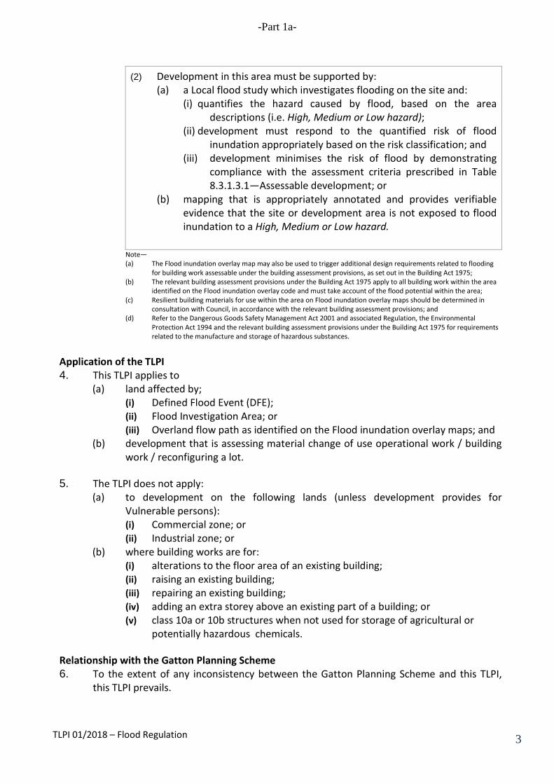
(2) Development in this area must be supported by: (a) a Local flood study which investigates flooding on the site and:
(i) quantifies the hazard caused by flood, based on the area descriptions (i.e. High, Medium or Low hazard);
(ii) development must respond to the quantified risk of flood inundation appropriately based on the risk classification; and
(iii) development minimises the risk of flood by demonstrating compliance with the assessment criteria prescribed in Table 8.3.1.3.1—Assessable development; or
(b) mapping that is appropriately annotated and provides verifiable evidence that the site or development area is not exposed to flood inundation to a High, Medium or Low hazard.
Note— (a) The Flood inundation overlay map may also be used to trigger additional design requirements related to flooding
for building work assessable under the building assessment provisions, as set out in the Building Act 1975; (b) The relevant building assessment provisions under the Building Act 1975 apply to all building work within the area
identified on the Flood inundation overlay code and must take account of the flood potential within the area; (c) Resilient building materials for use within the area on Flood inundation overlay maps should be determined in
consultation with Council, in accordance with the relevant building assessment provisions; and (d) Refer to the Dangerous Goods Safety Management Act 2001 and associated Regulation, the Environmental
Protection Act 1994 and the relevant building assessment provisions under the Building Act 1975 for requirements related to the manufacture and storage of hazardous substances.
Application of the TLPI 4. This TLPI applies to
(a) land affected by; (i) Defined Flood Event (DFE); (ii) Flood Investigation Area; or (iii) Overland flow path as identified on the Flood inundation overlay maps; and
(b) development that is assessing material change of use operational work / building work / reconfiguring a lot.
5. The TLPI does not apply:
(a) to development on the following lands (unless development provides for Vulnerable persons): (i) Commercial zone; or (ii) Industrial zone; or
(b) where building works are for: (i) alterations to the floor area of an existing building; (ii) raising an existing building; (iii) repairing an existing building; (iv) adding an extra storey above an existing part of a building; or (v) class 10a or 10b structures when not used for storage of agricultural or
potentially hazardous chemicals.
Relationship with the Gatton Planning Scheme 6. To the extent of any inconsistency between the Gatton Planning Scheme and this TLPI,
this TLPI prevails.
TLPI 01/2018 – Flood Regulation 3
-Part 1a-
Duration of the TLPI 7. This TLPI has effect for a period of up one (1) year from the date of commencement or
until a new planning scheme for the Lockyer Valley Regional Council area takes effect.
Definitions 8. Unless otherwise defined in this TLPI or the Gatton Planning Scheme, the terms used in
this TLPI have the same meaning as defined in the Sustainable Planning Act 2009.
9. In this TLPI the following terms shall have the meaning below: (a) “Additional Desired Environmental Outcome, Specific Outcomes, and Acceptable
Solutions” means the provisions contained in Attachment 1D. (b) “Defined Flood Level” means the flood level which the Council may from time to
time determine. (c) “Flood Inundation Overlay” means Overlay Map F: Flood Inundation Areas shown
in Attachment 1A. (d) “High Hazard Area” means the area on the Flood Inundation Overlay identified as
a High Hazard Area. (e) “Medium Hazard Area” means the area on the Flood Inundation Overlay identified
as a Medium Hazard Area. (f) “Low Hazard Area” means the area on the Flood Inundation Overlay identified as a
Low Hazard Area. (g) "Overland Flow Paths" means any low-lying natural drainage paths or channel,
open space floodway channels, road reserves, pavement expanses or any other flow paths that can convey flows of water.
(h) “Vulnerable Persons” means persons whom are identified as having a high degree of susceptibility and low resilience to flood hazard, variously defined include: unaccompanied minors, the infirm, mentally and physically disabled and elderly and may include the following uses; child care centres, pre-schools, schools, hospitals, retirement homes and villages, nursing home or hospices.
Effect of this TLPI 10. This TLPI suspends the operation of the provisions of the Gatton Planning Scheme
identified in Attachment 1B.
11. The Overlay Map F: Flood Inundation Areas (Attachment 1A) is taken to be an overlay map for the purposes of section 1.10 and 1.11 of the Gatton Planning Scheme.
12. For the duration of the TLPI, the provisions contained in Attachment 1C provide altered
assessment levels for land identified on Map F.
13. Development specified in Table 1, Column 1 of Attachment 1D: (a) has the level of assessment specified in Column 2; and (b) must comply with the applicable codes in Column 3 and the Additional Desired
Environmental Outcome, Specific Outcomes and Acceptable Solutions.
TLPI 01/2018 – Flood Regulation 4
-Part 1a-
14. Map F1 of this TLPI represents Natural Hazard Management Areas (Flood) as defined in State Planning Policy (SPP).
TLPI 01/2018 – Flood Regulation 5

-Part 1a-
Attachment 1A
OVERLAY MAP F: FLOOD INUNDATION AREAS
TLPI 01/2018 – Flood Regulation 6
-Part 1a-
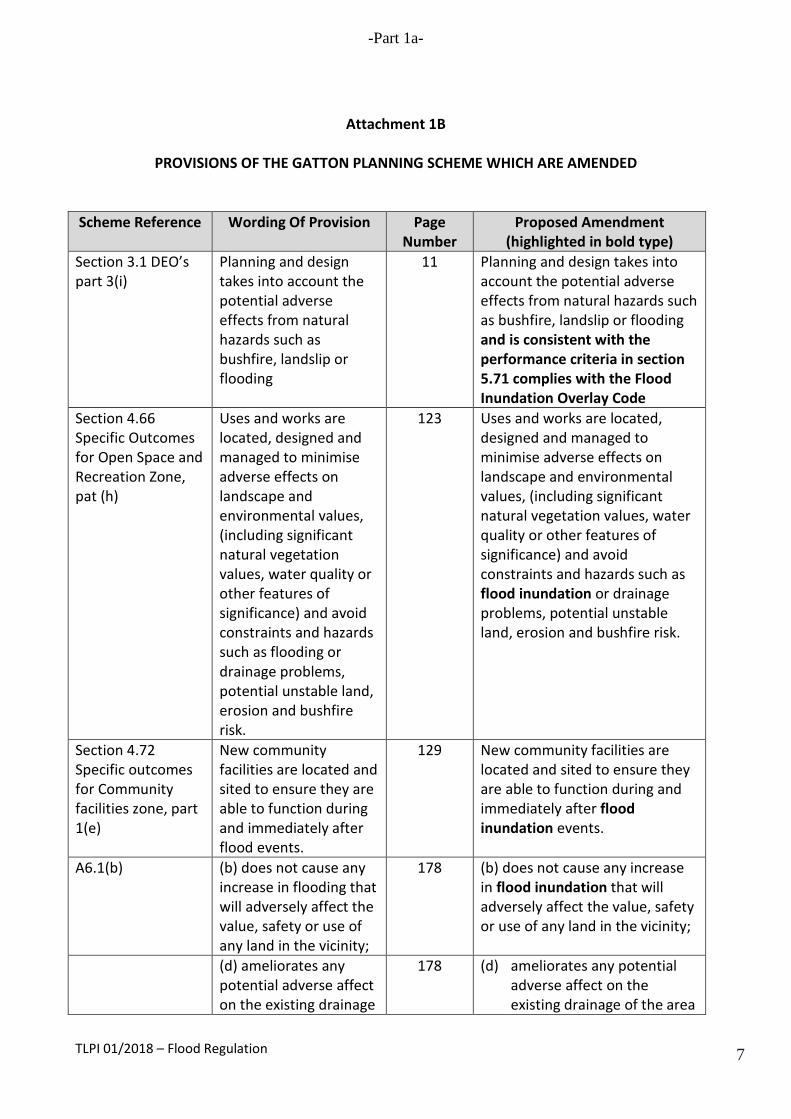
Attachment 1B
PROVISIONS OF THE GATTON PLANNING SCHEME WHICH ARE AMENDED
Scheme Reference Wording Of Provision Page
Number Proposed Amendment
(highlighted in bold type) Section 3.1 DEO’s part 3(i)
Planning and design takes into account the potential adverse effects from natural hazards such as bushfire, landslip or flooding
11 Planning and design takes into account the potential adverse effects from natural hazards such as bushfire, landslip or flooding and is consistent with the performance criteria in section 5.71 complies with the Flood Inundation Overlay Code
Section 4.66 Specific Outcomes for Open Space and Recreation Zone, pat (h)
Uses and works are located, designed and managed to minimise adverse effects on landscape and environmental values, (including significant natural vegetation values, water quality or other features of significance) and avoid constraints and hazards such as flooding or drainage problems, potential unstable land, erosion and bushfire risk.
123 Uses and works are located, designed and managed to minimise adverse effects on landscape and environmental values, (including significant natural vegetation values, water quality or other features of significance) and avoid constraints and hazards such as flood inundation or drainage problems, potential unstable land, erosion and bushfire risk.
Section 4.72 Specific outcomes for Community facilities zone, part 1(e)
New community facilities are located and sited to ensure they are able to function during and immediately after flood events.
129 New community facilities are located and sited to ensure they are able to function during and immediately after flood inundation events.
A6.1(b) (b) does not cause any increase in flooding that will adversely affect the value, safety or use of any land in the vicinity;
178 (b) does not cause any increase in flood inundation that will adversely affect the value, safety or use of any land in the vicinity;
(d) ameliorates any potential adverse affect on the existing drainage
178 (d) ameliorates any potential adverse affect on the existing drainage of the area
TLPI 01/2018 – Flood Regulation 7
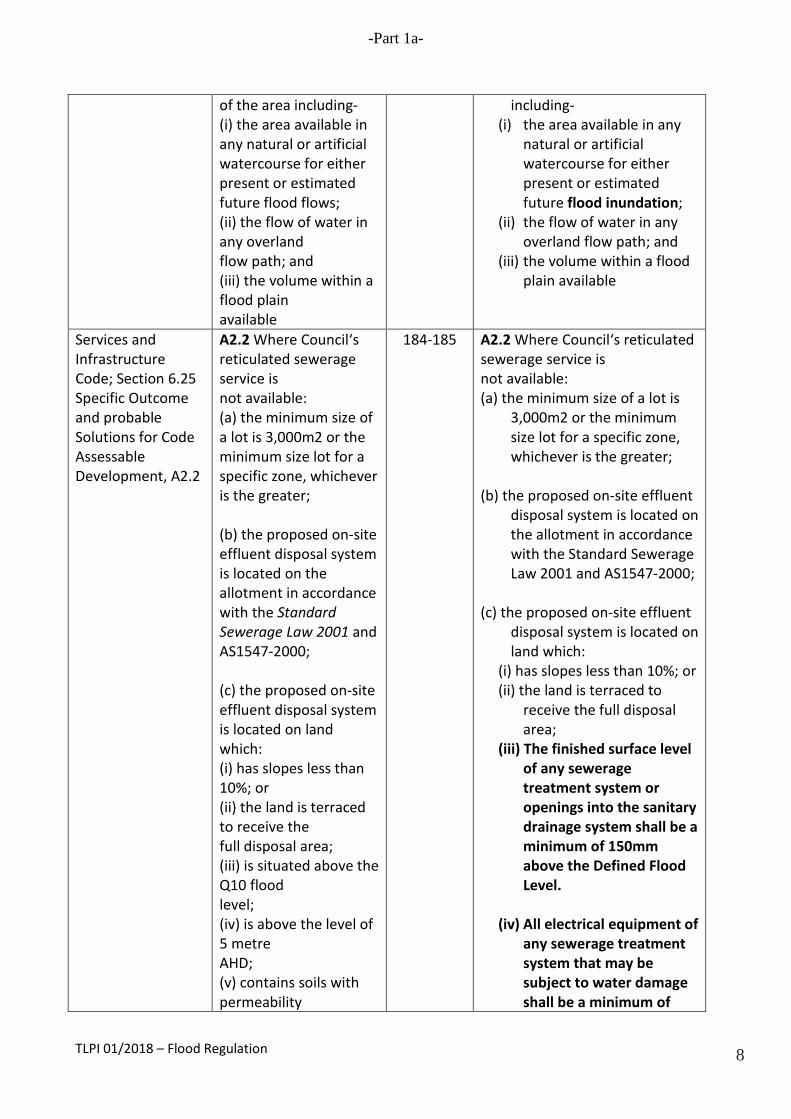
-Part 1a-
of the area including- (i) the area available in any natural or artificial watercourse for either present or estimated future flood flows; (ii) the flow of water in any overland flow path; and (iii) the volume within a flood plain available
including- (i) the area available in any
natural or artificial watercourse for either present or estimated future flood inundation;
(ii) the flow of water in any overland flow path; and
(iii) the volume within a flood plain available
Services and Infrastructure Code; Section 6.25 Specific Outcome and probable Solutions for Code Assessable Development, A2.2
A2.2 Where Council‘s reticulated sewerage service is not available: (a) the minimum size of a lot is 3,000m2 or the minimum size lot for a specific zone, whichever is the greater; (b) the proposed on-site effluent disposal system is located on the allotment in accordance with the Standard Sewerage Law 2001 and AS1547-2000; (c) the proposed on-site effluent disposal system is located on land which: (i) has slopes less than 10%; or (ii) the land is terraced to receive the full disposal area; (iii) is situated above the Q10 flood level; (iv) is above the level of 5 metre AHD; (v) contains soils with permeability
184-185 A2.2 Where Council‘s reticulated sewerage service is not available: (a) the minimum size of a lot is
3,000m2 or the minimum size lot for a specific zone, whichever is the greater;
(b) the proposed on-site effluent
disposal system is located on the allotment in accordance with the Standard Sewerage Law 2001 and AS1547-2000;
(c) the proposed on-site effluent
disposal system is located on land which:
(i) has slopes less than 10%; or (ii) the land is terraced to
receive the full disposal area;
(iii) The finished surface level of any sewerage treatment system or openings into the sanitary drainage system shall be a minimum of 150mm above the Defined Flood Level.
(iv) All electrical equipment of
any sewerage treatment system that may be subject to water damage shall be a minimum of
TLPI 01/2018 – Flood Regulation 8

-Part 1a-
greater than 0.05m / day and less than 3.5m / day; (i) contains soils which do not include mainly sand, gravel or fractured rock; (ii) is more than 0.6metres of the seasonally high water table; (iii) is more than 1.0 metre above bedrock; (d) the lot contains an area capable of supporting a land application area sized in accordance with the Interim Code of Practice for On-site Sewerage Facilities; (e) at least 100% of the design area is available on the lot and reserved for waste disposal application; and (f) the effluent irrigation area is not separated from the effluent source by features such as
150mm above the Defined Flood Level.
(v) All proposed effluent land
application areas that will be located below the Defined Flood Level shall be treated to an advanced secondary quality.
(vi) contains soils with permeability greater than 0.05m / day and less than 3.5m / day;
(vii) contains soils which do not include mainly sand, gravel or fractured rock;
(viii) is more than 0.6metres of the seasonally high water table;
(ix) is more than 1.0 metre above bedrock;
(d) the lot contains an area
capable of supporting a land application area sized in accordance with the Interim Code of Practice for On-site Sewerage Facilities;
(e) at least 100% of the design
area is available on the lot and reserved for waste disposal application; and
(f) the effluent irrigation area is
not separated from the effluent source by features such as
Accommodation Unit and Dual Occupancy Code; Section 6.47 Specific Outcomes and Probable Solutions for Code Assessable
An acceptable level of flood immunity is provided for new accommodation units and dual occupancy units.
200 (a) Development in a High Hazard Area is avoided, including intensification of existing or approved uses.
(b) Development in a Medium
Hazard Area is avoided, including intensification of
TLPI 01/2018 – Flood Regulation 9

-Part 1a-
Development, P3 existing or approved uses. (c) In the Low Hazard Area,
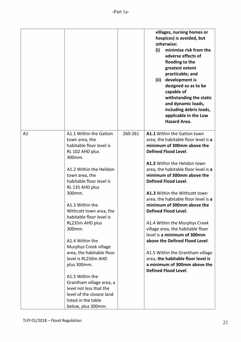
development that caters for vulnerable persons (such as child care centres, pre-schools, schools, hospitals, retirement homes and villages, nursing homes or hospices) is avoided, but otherwise:
(i) minimise risk from the
adverse effects of flooding to the greatest extent practicable; and
(ii) development is
designed so as to be capable of withstanding the static and dynamic loads, including debris loads, applicable in the Low Hazard Area.
A3 A3.1 Within the Gatton
town area, the habitable floor level is RL 102.041 plus 300mm. A3.2 Within the Helidon town area, the habitable floor level is RL 135 AHD plus 300mm. A3.3 Within the Withcott town area, the habitable floor level is RL235m AHD plus 300mm.
200 A3.1 Within the Gatton town area, the habitable floor level is a minimum of 300mm above the Defined Flood Level. A3.2 Within the Helidon town area, the habitable floor level is a minimum of 300mm above the Defined Flood Level. A3.3 Within the Withcott town area, the habitable floor level is a minimum of 300mm above the Defined Flood Level.
Annexed Unit Code; Section 6.51 Specific Outcome and Probable Solutions for Code Assessable Development, P1
An acceptable level of flood immunity is provided for a new annexed unit.
205 The floor levels of any habitable room of a proposed building or extension to an existing building are a minimum of 300mm above the Defined Flood Level
A1 A1.1 Within the Gatton A1.1 Within the Gatton town
TLPI 01/2018 – Flood Regulation 10
-Part 1a-
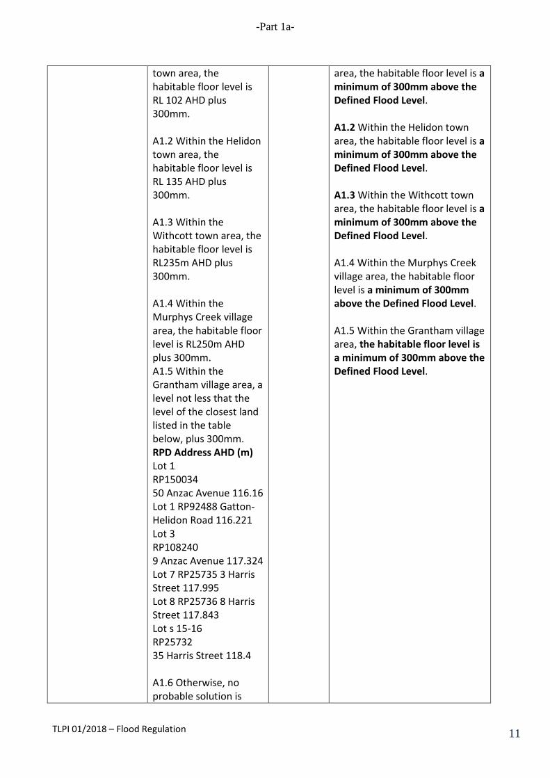
town area, the habitable floor level is RL 102 AHD plus 300mm. A1.2 Within the Helidon town area, the habitable floor level is RL 135 AHD plus 300mm. A1.3 Within the Withcott town area, the habitable floor level is RL235m AHD plus 300mm. A1.4 Within the Murphys Creek village area, the habitable floor level is RL250m AHD plus 300mm. A1.5 Within the Grantham village area, a level not less that the level of the closest land listed in the table below, plus 300mm. RPD Address AHD (m) Lot 1 RP150034 50 Anzac Avenue 116.16 Lot 1 RP92488 Gatton-Helidon Road 116.221 Lot 3 RP108240 9 Anzac Avenue 117.324 Lot 7 RP25735 3 Harris Street 117.995 Lot 8 RP25736 8 Harris Street 117.843 Lot s 15-16 RP25732 35 Harris Street 118.4 A1.6 Otherwise, no probable solution is
area, the habitable floor level is a minimum of 300mm above the Defined Flood Level. A1.2 Within the Helidon town area, the habitable floor level is a minimum of 300mm above the Defined Flood Level. A1.3 Within the Withcott town area, the habitable floor level is a minimum of 300mm above the Defined Flood Level. A1.4 Within the Murphys Creek village area, the habitable floor level is a minimum of 300mm above the Defined Flood Level. A1.5 Within the Grantham village area, the habitable floor level is a minimum of 300mm above the Defined Flood Level.
TLPI 01/2018 – Flood Regulation 11
-Part 1a-
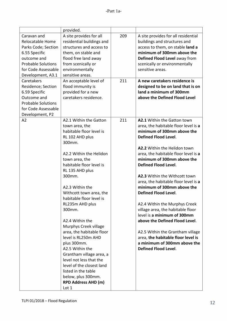
provided. Caravan and Relocatable Home Parks Code; Section 6.55 Specific outcome and Probable Solutions for Code Assessable Development, A3.1
A site provides for all residential buildings and structures and access to them, on stable and flood free land away from scenically or environmentally sensitive areas.
209 A site provides for all residential buildings and structures and access to them, on stable land a minimum of 300mm above the Defined Flood Level away from scenically or environmentally sensitive areas.
Caretakers Residence; Section 6.59 Specific Outcome and Probable Solutions for Code Assessable Development, P2
An acceptable level of flood immunity is provided for a new caretakers residence.
211 A new caretakers residence is designed to be on land that is on land a minimum of 300mm above the Defined Flood Level
A2 A2.1 Within the Gatton town area, the habitable floor level is RL 102 AHD plus 300mm. A2.2 Within the Helidon town area, the habitable floor level is RL 135 AHD plus 300mm. A2.3 Within the Withcott town area, the habitable floor level is RL235m AHD plus 300mm. A2.4 Within the Murphys Creek village area, the habitable floor level is RL250m AHD plus 300mm. A2.5 Within the Grantham village area, a level not less that the level of the closest land listed in the table below, plus 300mm. RPD Address AHD (m) Lot 1
211 A2.1 Within the Gatton town area, the habitable floor level is a minimum of 300mm above the Defined Flood Level. A2.2 Within the Helidon town area, the habitable floor level is a minimum of 300mm above the Defined Flood Level. A2.3 Within the Withcott town area, the habitable floor level is a minimum of 300mm above the Defined Flood Level. A2.4 Within the Murphys Creek village area, the habitable floor level is a minimum of 300mm above the Defined Flood Level. A2.5 Within the Grantham village area, the habitable floor level is a minimum of 300mm above the Defined Flood Level.
TLPI 01/2018 – Flood Regulation 12
-Part 1a-
RP150034 50 Anzac Avenue 116.16 Lot 1 RP92488 Gatton-Helidon Road 116.221 Lot 3 RP108240 9 Anzac Avenue 117.324 Lot 7 RP25735 3 Harris Street 117.995 Lot 8 RP25736 8 Harris Street 117.843 Lot s 15-16 RP25732 35 Harris Street 118.4 A2.6 Otherwise, no probable solution is provided.
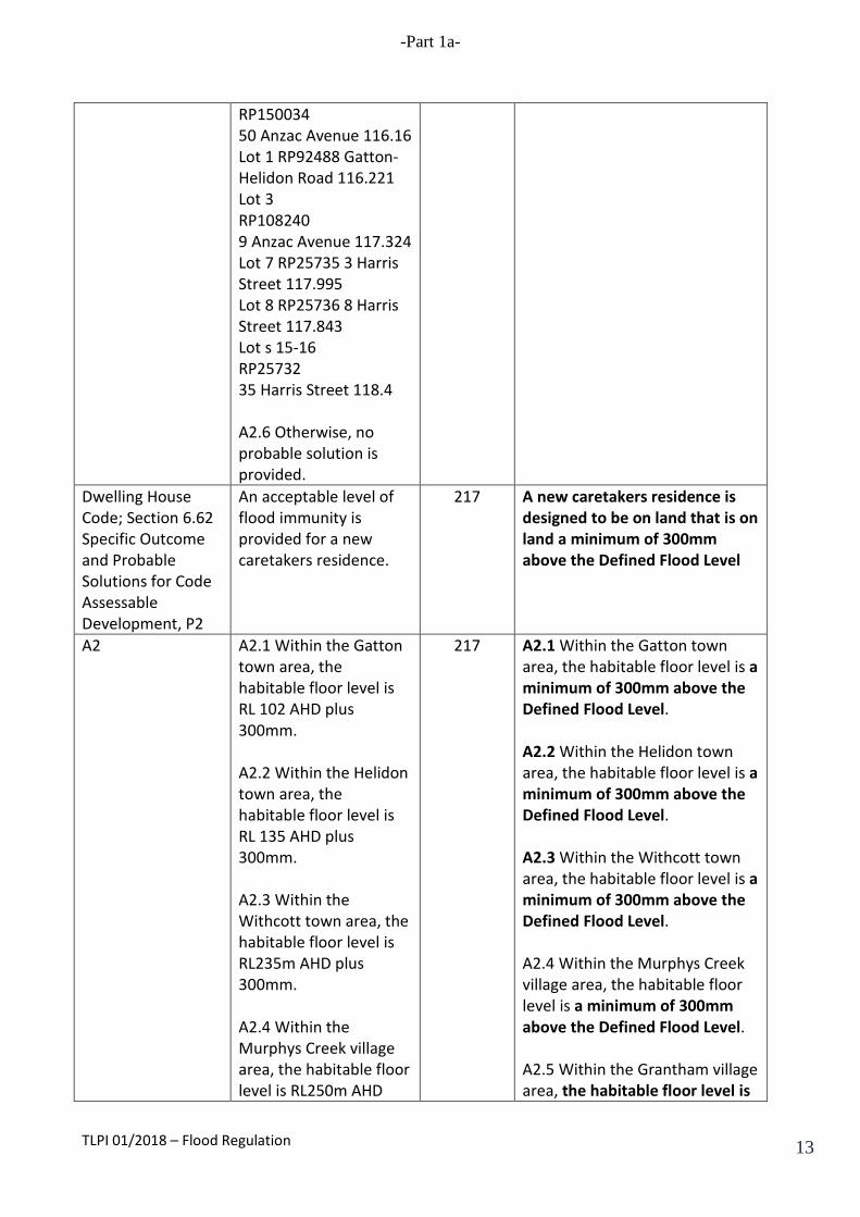
Dwelling House Code; Section 6.62 Specific Outcome and Probable Solutions for Code Assessable Development, P2
An acceptable level of flood immunity is provided for a new caretakers residence.
217 A new caretakers residence is designed to be on land that is on land a minimum of 300mm above the Defined Flood Level
A2 A2.1 Within the Gatton town area, the habitable floor level is RL 102 AHD plus 300mm. A2.2 Within the Helidon town area, the habitable floor level is RL 135 AHD plus 300mm. A2.3 Within the Withcott town area, the habitable floor level is RL235m AHD plus 300mm. A2.4 Within the Murphys Creek village area, the habitable floor level is RL250m AHD
217 A2.1 Within the Gatton town area, the habitable floor level is a minimum of 300mm above the Defined Flood Level. A2.2 Within the Helidon town area, the habitable floor level is a minimum of 300mm above the Defined Flood Level. A2.3 Within the Withcott town area, the habitable floor level is a minimum of 300mm above the Defined Flood Level. A2.4 Within the Murphys Creek village area, the habitable floor level is a minimum of 300mm above the Defined Flood Level. A2.5 Within the Grantham village area, the habitable floor level is
TLPI 01/2018 – Flood Regulation 13
-Part 1a-
plus 300mm. A2.5 Within the Grantham village area, a level not less that the level of the closest land listed in the table below, plus 300mm. RPD Address AHD (m) Lot 1 RP150034 50 Anzac Avenue 116.16 Lot 1 RP92488 Gatton-Helidon Road 116.221 Lot 3 RP108240 9 Anzac Avenue 117.324 Lot 7 RP25735 3 Harris Street 117.995 Lot 8 RP25736 8 Harris Street 117.843 Lot s 15-16 RP25732 35 Harris Street 118.4 A2.6 Otherwise, no probable solution is provided.
a minimum of 300mm above the Defined Flood Level.
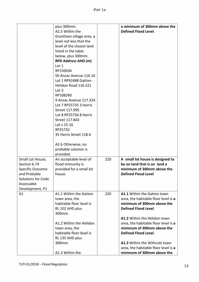
Small Lot House; Section 6.74 Specific Outcome and Probable Solutions for Code Assessable Development, P1
An acceptable level of flood immunity is provided for a small lot house.
220 A small lot house is designed to be on land that is on land a minimum of 300mm above the Defined Flood Level
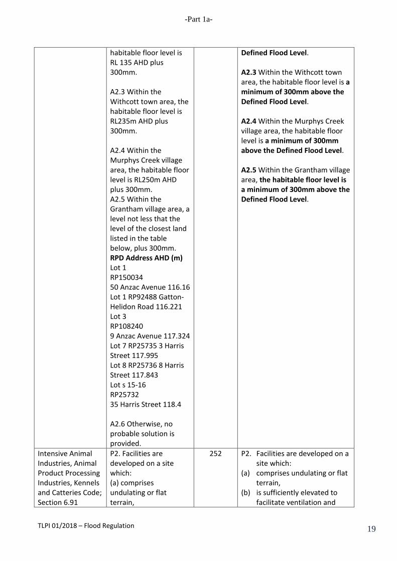
A1 A1.1 Within the Gatton town area, the habitable floor level is RL 102 AHD plus 300mm. A1.2 Within the Helidon town area, the habitable floor level is RL 135 AHD plus 300mm. A1.3 Within the
220 A1.1 Within the Gatton town area, the habitable floor level is a minimum of 300mm above the Defined Flood Level. A1.2 Within the Helidon town area, the habitable floor level is a minimum of 300mm above the Defined Flood Level. A1.3 Within the Withcott town area, the habitable floor level is a minimum of 300mm above the
TLPI 01/2018 – Flood Regulation 14

-Part 1a-
Withcott town area, the habitable floor level is RL235m AHD plus 300mm. A1.4 Within the Murphys Creek village area, the habitable floor level is RL250m AHD plus 300mm. A1.5 Within the Grantham village area, a level not less that the level of the closest land listed in the table below, plus 300mm. RPD Address AHD (m) Lot 1 RP150034 50 Anzac Avenue 116.16 Lot 1 RP92488 Gatton-Helidon Road 116.221 Lot 3 RP108240 9 Anzac Avenue 117.324 Lot 7 RP25735 3 Harris Street 117.995 Lot 8 RP25736 8 Harris Street 117.843 Lot s 15-16 RP25732 35 Harris Street 118.4 A1.6 Otherwise, no probable solution is provided.
Defined Flood Level. A1.4 Within the Murphys Creek village area, the habitable floor level is a minimum of 300mm above the Defined Flood Level. A1.5 Within the Grantham village area, the habitable floor level is a minimum of 300mm above the Defined Flood Level.
Commercial Premises and Shops Code; Section 6.78 Specific Outcome and Probable Solutions for Code Assessable Development, P2
An acceptable level of flood immunity is provided for new commercial premises and shops.
224 1. New commercial premises and shops are designed to: (a) minimise risk from the
adverse effects of flooding to the greatest extent practicable; and
(b) to be capable of withstanding the static and dynamic loads, including debris loads.
TLPI 01/2018 – Flood Regulation 15
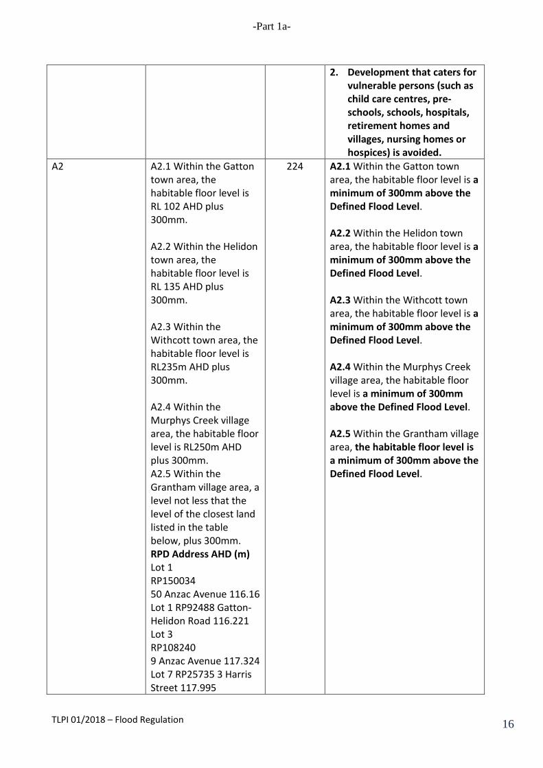
-Part 1a-
2. Development that caters for vulnerable persons (such as child care centres, pre-schools, schools, hospitals, retirement homes and villages, nursing homes or hospices) is avoided.
A2 A2.1 Within the Gatton town area, the habitable floor level is RL 102 AHD plus 300mm. A2.2 Within the Helidon town area, the habitable floor level is RL 135 AHD plus 300mm. A2.3 Within the Withcott town area, the habitable floor level is RL235m AHD plus 300mm. A2.4 Within the Murphys Creek village area, the habitable floor level is RL250m AHD plus 300mm. A2.5 Within the Grantham village area, a level not less that the level of the closest land listed in the table below, plus 300mm. RPD Address AHD (m) Lot 1 RP150034 50 Anzac Avenue 116.16 Lot 1 RP92488 Gatton-Helidon Road 116.221 Lot 3 RP108240 9 Anzac Avenue 117.324 Lot 7 RP25735 3 Harris Street 117.995
224 A2.1 Within the Gatton town area, the habitable floor level is a minimum of 300mm above the Defined Flood Level. A2.2 Within the Helidon town area, the habitable floor level is a minimum of 300mm above the Defined Flood Level. A2.3 Within the Withcott town area, the habitable floor level is a minimum of 300mm above the Defined Flood Level. A2.4 Within the Murphys Creek village area, the habitable floor level is a minimum of 300mm above the Defined Flood Level. A2.5 Within the Grantham village area, the habitable floor level is a minimum of 300mm above the Defined Flood Level.
TLPI 01/2018 – Flood Regulation 16

-Part 1a-
Lot 8 RP25736 8 Harris Street 117.843 Lot s 15-16 RP25732 35 Harris Street 118.4 A2.6 Otherwise, no probable solution is provided.
Service Station and Car Wash Code; Section 6.82 Specific Outcome and Probable Solutions for Code Assessable Development, P2
An acceptable level of flood immunity is provided for a new service station and car wash.
238 A new service station and car wash is designed to: 1. minimise risk from the
adverse effects of flooding to the greatest extent practicable; and
2. to be capable of withstanding the static and dynamic loads, including debris loads.
A2 A2.1 Within the Gatton
town area, the habitable floor level is RL 102 AHD plus 300mm. A2.2 Within the Helidon town area, the habitable floor level is RL 135 AHD plus 300mm. A2.3 Within the Withcott town area, the habitable floor level is RL235m AHD plus 300mm. A2.4 Within the Murphys Creek village area, the habitable floor level is RL250m AHD plus 300mm. A2.5 Within the Grantham village area, a level not less that the level of the closest land
238 A2.1 Within the Gatton town area, the habitable floor level is a minimum of 300mm above the Defined Flood Level. A2.2 Within the Helidon town area, the habitable floor level is a minimum of 300mm above the Defined Flood Level. A2.3 Within the Withcott town area, the habitable floor level is a minimum of 300mm above the Defined Flood Level. A2.4 Within the Murphys Creek village area, the habitable floor level is a minimum of 300mm above the Defined Flood Level. A2.5 Within the Grantham village area, the habitable floor level is a minimum of 300mm above the Defined Flood Level.
TLPI 01/2018 – Flood Regulation 17

-Part 1a-
listed in the table below, plus 300mm. RPD Address AHD (m) Lot 1 RP150034 50 Anzac Avenue 116.16 Lot 1 RP92488 Gatton-Helidon Road 116.221 Lot 3 RP108240 9 Anzac Avenue 117.324 Lot 7 RP25735 3 Harris Street 117.995 Lot 8 RP25736 8 Harris Street 117.843 Lot s 15-16 RP25732 35 Harris Street 118.4 A2.6 Otherwise, no probable solution is provided.
Industrial Development Code; Section 6.88 Specific Outcome and Probable Solutions for Code Assessable Development, P2
An acceptable level of flood immunity is provided for new industrial development.
247 1. New industrial development is designed to: (a) minimise risk from the
adverse effects of flooding to the greatest extent practicable; and
(b) to be capable of withstanding the static and dynamic loads, including debris loads.
2. Development that caters for vulnerable persons (such as child care centres, pre-schools, schools, hospitals, retirement homes and villages, nursing homes or hospices) is avoided.
A2 A2.1 Within the Gatton town area, the habitable floor level is RL 102 AHD plus 300mm. A2.2 Within the Helidon town area, the
247 A2.1 Within the Gatton town area, the habitable floor level is a minimum of 300mm above the Defined Flood Level. A2.2 Within the Helidon town area, the habitable floor level is a minimum of 300mm above the
TLPI 01/2018 – Flood Regulation 18
-Part 1a-
habitable floor level is RL 135 AHD plus 300mm. A2.3 Within the Withcott town area, the habitable floor level is RL235m AHD plus 300mm. A2.4 Within the Murphys Creek village area, the habitable floor level is RL250m AHD plus 300mm. A2.5 Within the Grantham village area, a level not less that the level of the closest land listed in the table below, plus 300mm. RPD Address AHD (m) Lot 1 RP150034 50 Anzac Avenue 116.16 Lot 1 RP92488 Gatton-Helidon Road 116.221 Lot 3 RP108240 9 Anzac Avenue 117.324 Lot 7 RP25735 3 Harris Street 117.995 Lot 8 RP25736 8 Harris Street 117.843 Lot s 15-16 RP25732 35 Harris Street 118.4 A2.6 Otherwise, no probable solution is provided.
Defined Flood Level. A2.3 Within the Withcott town area, the habitable floor level is a minimum of 300mm above the Defined Flood Level. A2.4 Within the Murphys Creek village area, the habitable floor level is a minimum of 300mm above the Defined Flood Level. A2.5 Within the Grantham village area, the habitable floor level is a minimum of 300mm above the Defined Flood Level.
Intensive Animal Industries, Animal Product Processing Industries, Kennels and Catteries Code; Section 6.91
P2. Facilities are developed on a site which: (a) comprises undulating or flat terrain,
252 P2. Facilities are developed on a site which:
(a) comprises undulating or flat terrain,
(b) is sufficiently elevated to facilitate ventilation and
TLPI 01/2018 – Flood Regulation 19

-Part 1a-
Specific Outcome and Probable Solutions for Code Assessable Development, P2
(b) is sufficiently elevated to facilitate ventilation and drainage, (c) has adequate vehicle access, (d) is not subject to flooding, and (e) is supplied with a reliable, good quality water supply.
drainage, (c) has adequate vehicle access, (d) is not subject to flood
inundation, and (e) is supplied with a reliable,
good quality water supply.
A2 A2.1 Facilities are developed on a site which: (a) has land with slopes less than 10%; (b) is not on land subject to flooding at a frequency of greater than 1 in 50 years; (c) is otherwise not low-lying; (d) has sealed road access ; (e) is provided with a reliable water supply and has a capacity to store a minimum of 2 days' supply; and (f) is connected to an electricity supply.
252 A2.1 Facilities are developed on a site which: (a) has land with slopes less
than 10%; (b) is above the Defined Flood
Level; (c) is otherwise not low-lying; (d) has sealed road access ; (e) is provided with a reliable
water supply and has a capacity to store a minimum of 2 days' supply; and
(f) is connected to an electricity supply.
Reconfiguring a Lot Code; Section 6.107 Specific Outcome and Probable Solutions for Code Assessable Development, P1
Flood Immunity P1. An acceptable level of flood immunity is provided for new residential lots.
260 (a) Development in a High Hazard Area is avoided, including intensification of existing or approved uses.
(b) Development in a Medium
Hazard Area is avoided, including intensification of existing or approved uses.
(c) In the Low Hazard Area,
development that caters for vulnerable persons (such as child care centres, pre-schools, schools, hospitals, retirement homes and
TLPI 01/2018 – Flood Regulation 20
-Part 1a-
villages, nursing homes or hospices) is avoided, but otherwise: (i) minimise risk from the
adverse effects of flooding to the greatest extent practicable; and
(ii) development is designed so as to be capable of withstanding the static and dynamic loads, including debris loads, applicable in the Low Hazard Area.
A1 A1.1 Within the Gatton
town area, the habitable floor level is RL 102 AHD plus 300mm. A1.2 Within the Helidon town area, the habitable floor level is RL 135 AHD plus 300mm. A1.3 Within the Withcott town area, the habitable floor level is RL235m AHD plus 300mm. A1.4 Within the Murphys Creek village area, the habitable floor level is RL250m AHD plus 300mm. A1.5 Within the Grantham village area, a level not less that the level of the closest land listed in the table below, plus 300mm.
260-261 A1.1 Within the Gatton town area, the habitable floor level is a minimum of 300mm above the Defined Flood Level. A1.2 Within the Helidon town area, the habitable floor level is a minimum of 300mm above the Defined Flood Level. A1.3 Within the Withcott town area, the habitable floor level is a minimum of 300mm above the Defined Flood Level. A1.4 Within the Murphys Creek village area, the habitable floor level is a minimum of 300mm above the Defined Flood Level. A1.5 Within the Grantham village area, the habitable floor level is a minimum of 300mm above the Defined Flood Level.
TLPI 01/2018 – Flood Regulation 21
-Part 1a-
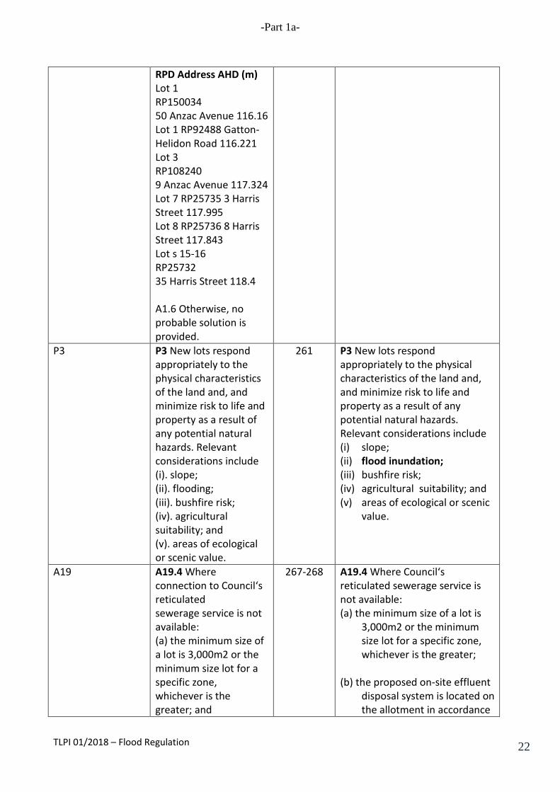
RPD Address AHD (m) Lot 1 RP150034 50 Anzac Avenue 116.16 Lot 1 RP92488 Gatton-Helidon Road 116.221 Lot 3 RP108240 9 Anzac Avenue 117.324 Lot 7 RP25735 3 Harris Street 117.995 Lot 8 RP25736 8 Harris Street 117.843 Lot s 15-16 RP25732 35 Harris Street 118.4 A1.6 Otherwise, no probable solution is provided.
P3 P3 New lots respond appropriately to the physical characteristics of the land and, and minimize risk to life and property as a result of any potential natural hazards. Relevant considerations include (i). slope; (ii). flooding; (iii). bushfire risk; (iv). agricultural suitability; and (v). areas of ecological or scenic value.
261 P3 New lots respond appropriately to the physical characteristics of the land and, and minimize risk to life and property as a result of any potential natural hazards. Relevant considerations include (i) slope; (ii) flood inundation; (iii) bushfire risk; (iv) agricultural suitability; and (v) areas of ecological or scenic
value.
A19 A19.4 Where connection to Council‘s reticulated sewerage service is not available: (a) the minimum size of a lot is 3,000m2 or the minimum size lot for a specific zone, whichever is the greater; and
267-268
A19.4 Where Council‘s reticulated sewerage service is not available: (a) the minimum size of a lot is
3,000m2 or the minimum size lot for a specific zone, whichever is the greater;
(b) the proposed on-site effluent
disposal system is located on the allotment in accordance
TLPI 01/2018 – Flood Regulation 22
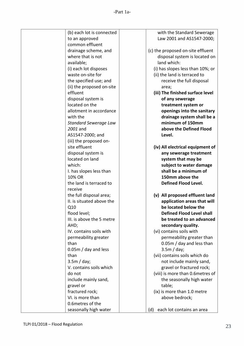
-Part 1a-
(b) each lot is connected to an approved common effluent drainage scheme, and where that is not available; (i) each lot disposes waste on-site for the specified use; and (ii) the proposed on-site effluent disposal system is located on the allotment in accordance with the Standard Sewerage Law 2001 and AS1547-2000; and (iii) the proposed on-site effluent disposal system is located on land which: I. has slopes less than 10% OR the land is terraced to receive the full disposal area; II. is situated above the Q10 flood level; III. is above the 5 metre AHD; IV. contains soils with permeability greater than 0.05m / day and less than 3.5m / day; V. contains soils which do not include mainly sand, gravel or fractured rock; VI. is more than 0.6metres of the seasonally high water
with the Standard Sewerage Law 2001 and AS1547-2000;
(c) the proposed on-site effluent
disposal system is located on land which:
(i) has slopes less than 10%; or (ii) the land is terraced to
receive the full disposal area;
(iii) The finished surface level of any sewerage treatment system or openings into the sanitary drainage system shall be a minimum of 150mm above the Defined Flood Level.
(iv) All electrical equipment of
any sewerage treatment system that may be subject to water damage shall be a minimum of 150mm above the Defined Flood Level.
(v) All proposed effluent land
application areas that will be located below the Defined Flood Level shall be treated to an advanced secondary quality.
(vi) contains soils with permeability greater than 0.05m / day and less than 3.5m / day;
(vii) contains soils which do not include mainly sand, gravel or fractured rock;
(viii) is more than 0.6metres of the seasonally high water table;
(ix) is more than 1.0 metre above bedrock;
(d) each lot contains an area
TLPI 01/2018 – Flood Regulation 23
-Part 1a-
table; VII. is more than 1.0 metre above bedrock; (c) each lot contains an area capable of supporting a land application area sized in accordance with the ‗Interim Code of Practice for On-site Sewerage Facilities’15; (d) an area of up to 100% of the design area is available on each lot and reserved for waste disposal application; and (e) the effluent irrigation area is a minimum of 50 metres from features such as gullies, waterways and wetlands.
capable of supporting a land application area sized in accordance with the Interim Code of Practice for On-site Sewerage Facilities;
(e) at least 100% of the design
area is available on the lot and reserved for waste disposal application; and
(e) the effluent irrigation area is
a minimum of 50 metres from features such as gullies, waterways and wetlands.
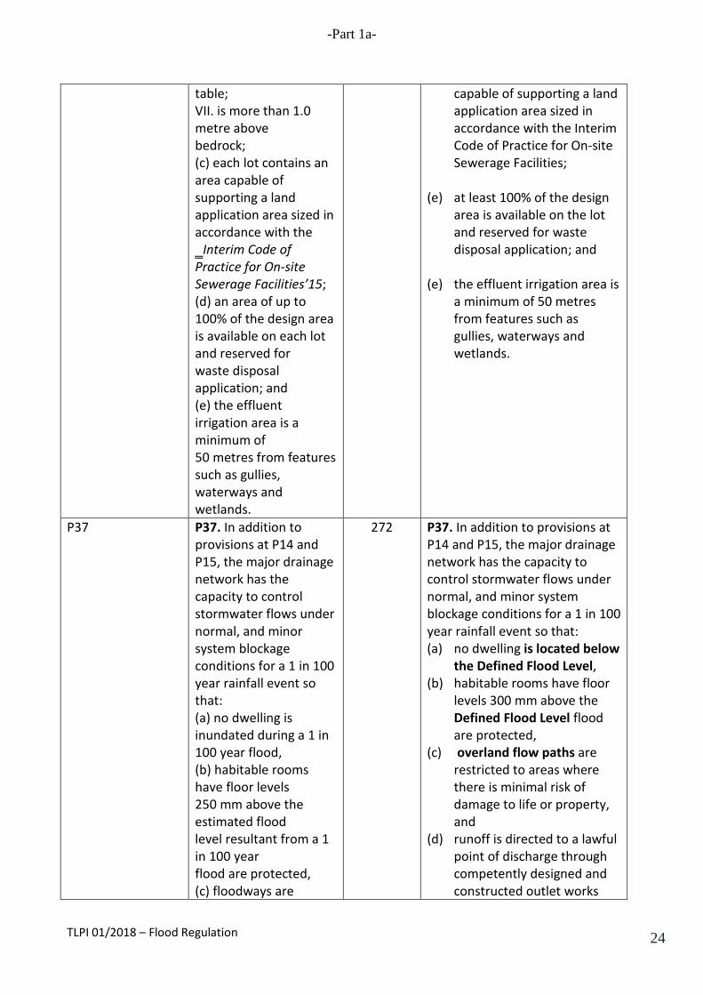
P37 P37. In addition to provisions at P14 and P15, the major drainage network has the capacity to control stormwater flows under normal, and minor system blockage conditions for a 1 in 100 year rainfall event so that: (a) no dwelling is inundated during a 1 in 100 year flood, (b) habitable rooms have floor levels 250 mm above the estimated flood level resultant from a 1 in 100 year flood are protected, (c) floodways are
272 P37. In addition to provisions at P14 and P15, the major drainage network has the capacity to control stormwater flows under normal, and minor system blockage conditions for a 1 in 100 year rainfall event so that: (a) no dwelling is located below
the Defined Flood Level, (b) habitable rooms have floor
levels 300 mm above the Defined Flood Level flood are protected,
(c) overland flow paths are restricted to areas where there is minimal risk of damage to life or property, and
(d) runoff is directed to a lawful point of discharge through competently designed and constructed outlet works
TLPI 01/2018 – Flood Regulation 24

-Part 1a-
restricted to areas where there is minimal risk of damage to life or property, and (d) runoff is directed to a lawful point of discharge through competently designed and constructed outlet works.
P42 P42. The boundaries of existing lots may be rearranged where this would: (a) aggregate agricultural land resources and maximizes the utility of the land for rural purposes, (b) provide for better land management; (c) respond to site characteristics and potential hazards, including soil erosion and bushfire risk, flood liability; and (d) protect special features such as vegetation and habitat, creeks, important landscape features and views, and features of cultural importance;
274 P42. The boundaries of existing lots may be rearranged where this would: (a) aggregate agricultural land
resources and maximizes the utility of the land for rural purposes,
(b) provide for better land management;
(c) respond to site characteristics and potential hazards, including soil erosion and bushfire risk, flood inundation; and
(d) protect special features such as vegetation and habitat, creeks, important landscape features and views, and features of cultural importance;
A43.1 A43.1 New lots resulting from the realignment have a minimum area of 1.0 hectare, and contain: (a) flood free building sites; (b) slopes less than 20%; (c) effluent disposal
274 A43.1 New lots resulting from the realignment have a minimum area of 1.0 hectare: (a) flood free building sites are
located above the Defined Flood Level;
(b) have slopes less than 20%; (c) have effluent disposal areas;
and
TLPI 01/2018 – Flood Regulation 25

-Part 1a-
areas; and (d) maintain a viable land size for ongoing agricultural use if on good quality agricultural land.
(d) maintain a viable land size for ongoing agricultural use if on good quality agricultural land.
Section 7.2 Schedule 1 – Dictionary
278 The following definitions are inserted into the scheme:
(a) “Additional Desired Environmental Outcome, Specific Outcomes, and Acceptable Solutions” means the provisions contained in Attachment 4.
(b) “Defined Flood Level” means the flood level which the Council may from time to time determine.
(c) “Flood Inundation Overlay” means Overlay Map: Flood Inundation Areas shown in Attachment 1.
(d) “High Hazard Area” means the area on the Flood Inundation Overlay identified as a High Hazard Area.
(e) “Medium Hazard Area” means the area on the Flood Inundation Overlay identified as a Medium Hazard Area.
(f) “Low Hazard Area” means the area on the Flood Inundation Overlay identified as a Low Hazard Area.
Section 8.4 PSP No. 3 – Preparation of Management Plans.
Part 3(b) Requires a description of the sites natural drainage patterns, water bodies, wetlands and
330 Part 3(b) Requires a description of the sites natural drainage patterns, water bodies, wetlands and flood inundation areas and seasonally wet areas etc and the
TLPI 01/2018 – Flood Regulation 26

-Part 1a-
floodplains and seasonally wet areas etc and the fisheries values of these features.
fisheries values of these features.
Section 8.7 PSP No. 6 – Earthworks
Part 2.2 Requires a hydraulic study including details regarding flood levels and impact on adjoining, upstream or down stream properties
337
Part 2.2 Requires a hydraulic study including details regarding flood inundation and impact on adjoining, upstream or down stream properties
TLPI 01/2018 – Flood Regulation 27

-Part 1a-
Attachment 1C
DIVISION 19 – ASSESSMENT TABLE FOR OVERLAY MAP F: FLOOD INUNDATION AREAS
5.65 Assessment categories for Flood Inundation Overlay The assessment categories are identified for development affected by Overlay Map F: Flood Inundation Areas in Column 2 of Table 1.
5.66 Relevant assessment criteria for development affected by Overlay Map F: Flood Inundation Areas (1) The relevant assessment criteria for development affected by Overlay Map F:
Flood Inundation Areas are referred to in Column 3 of Table 1.
(2) For code assessable development the relevant assessment criteria are the applicable codes.
TABLE 1 ASSESSMENT CATEGORY AND RELEVANT ASSESSMENT CRITERIA FOR FLOOD INUNDATION
OVERLAY CODE
Column 1 Defined Use or Use Class
Column 2 Assessment Category
Column 3 Applicable Code
Material Change of use Agriculture Exempt if no building work
proposed; Self Assessable if - class 10a or 10b structures and;
(a) used for storage of agricultural or potentially hazardous chemicals;
(b) complies with Self assessable criteria.
Code Assessable in all other circumstances
If Self Assessable – Flood Inundation Overlay Code If Code Assessable – Flood Inundation Overlay Code
Public Infrastructure Exempt if – development is not located within the DFE
Sport and Recreation Exempt if no building work proposed; Self Assessable if - class 10a or 10b structures and;
(a) used for storage of agricultural or potentially hazardous chemicals;
If Self Assessable – Flood Inundation Overlay Code
TLPI 01/2018 – Flood Regulation 28
-Part 1a-
(b) complies with Self assessable criteria.
Code Assessable in all other circumstances
If Code Assessable – Flood Inundation Overlay Code
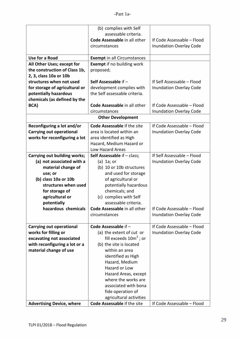
Use for a Road Exempt in all Circumstances All Other Uses; except for the construction of Class 1b, 2, 3, class 10a or 10b structures when not used for storage of agricultural or potentially hazardous chemicals (as defined by the BCA)
Exempt if no building work proposed; Self Assessable if – development complies with the Self assessable criteria. Code Assessable in all other circumstances
If Self Assessable – Flood Inundation Overlay Code If Code Assessable – Flood Inundation Overlay Code
Other Development
Reconfiguring a lot and/or Carrying out operational works for reconfiguring a lot
Code Assessable if the site area is located within an area identified as High Hazard, Medium Hazard or Low Hazard Areas
If Code Assessable – Flood Inundation Overlay Code
Carrying out building works; (a) not associated with a
material change of use; or
(b) class 10a or 10b structures when used for storage of agricultural or potentially hazardous chemicals
Self Assessable if – class; (a) 1a; or (b) 10 or 10b structures
and used for storage of agricultural or potentially hazardous chemicals; and
(c) complies with Self assessable criteria.
Code Assessable in all other circumstances
If Self Assessable – Flood Inundation Overlay Code If Code Assessable – Flood Inundation Overlay Code
Carrying out operational works for filling or excavating not associated with reconfiguring a lot or a material change of use
Code Assessable if – (a) the extent of cut or
fill exceeds 10m3 ; or (b) the site is located
within an area identified as High Hazard, Medium Hazard or Low Hazard Areas, except where the works are associated with bona fide operation of agricultural activities
If Code Assessable – Flood Inundation Overlay Code
Advertising Device, where Code Assessable if the site If Code Assessable – Flood
TLPI 01/2018 – Flood Regulation 29

-Part 1a-
not associated with a material change of use
area is located within an area identified as High Hazard, Medium Hazard or Low Hazard Areas
Inundation Overlay Code
Extracting Gravel, Rock, Sand or Soil, where not associated with a material change of use
Code Assessable if the site area is located within an area identified as High Hazard, Medium Hazard or Low Hazard Areas
If Code Assessable – Flood Inundation Overlay Code
Other Exempt
Attachment 1D
Desired Environmental Outcome (p)
The adverse effects of flooding on development:
(a) in the High and Medium Hazard Areas are avoided;
(b) in the Low Hazard Area are minimised to the greatest extent practicable and development is designed to provide protection to persons and property.
TLPI 01/2018 – Flood Regulation 30
-Part 1a-
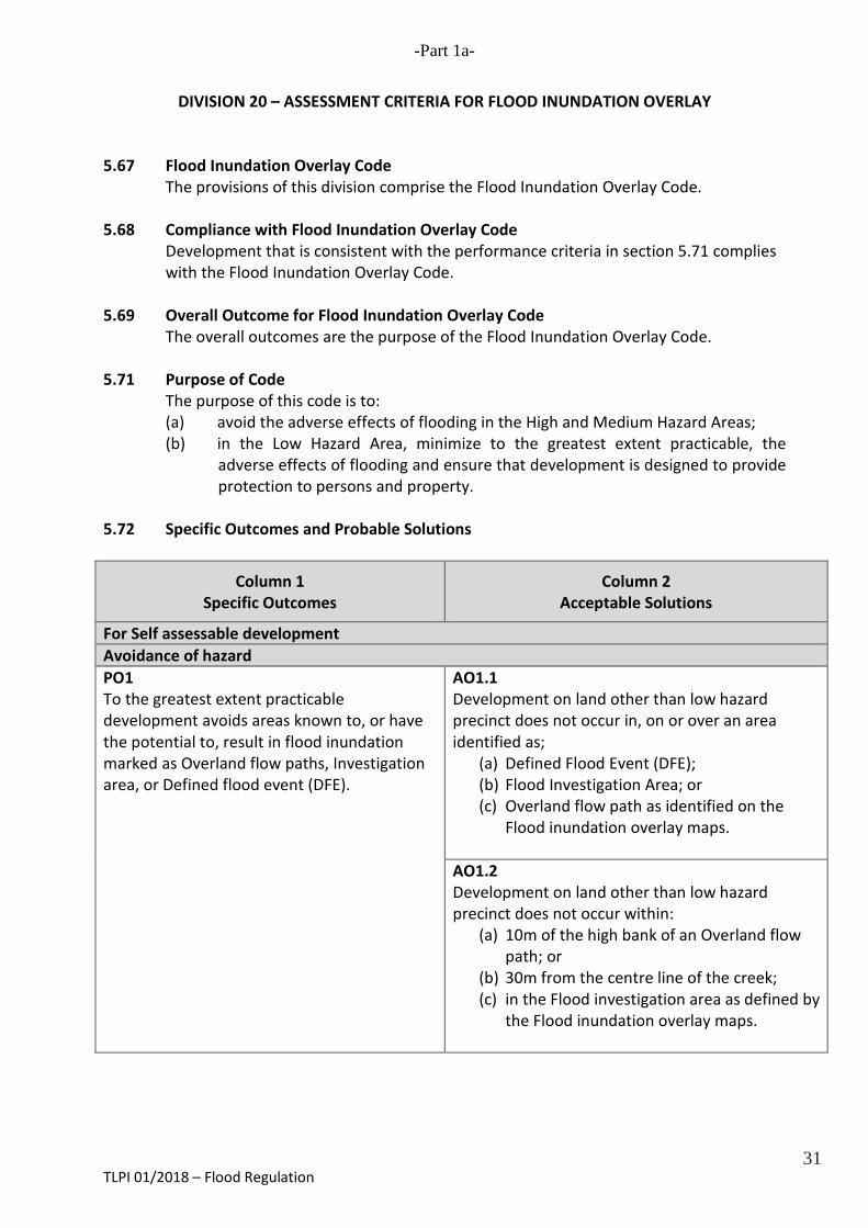
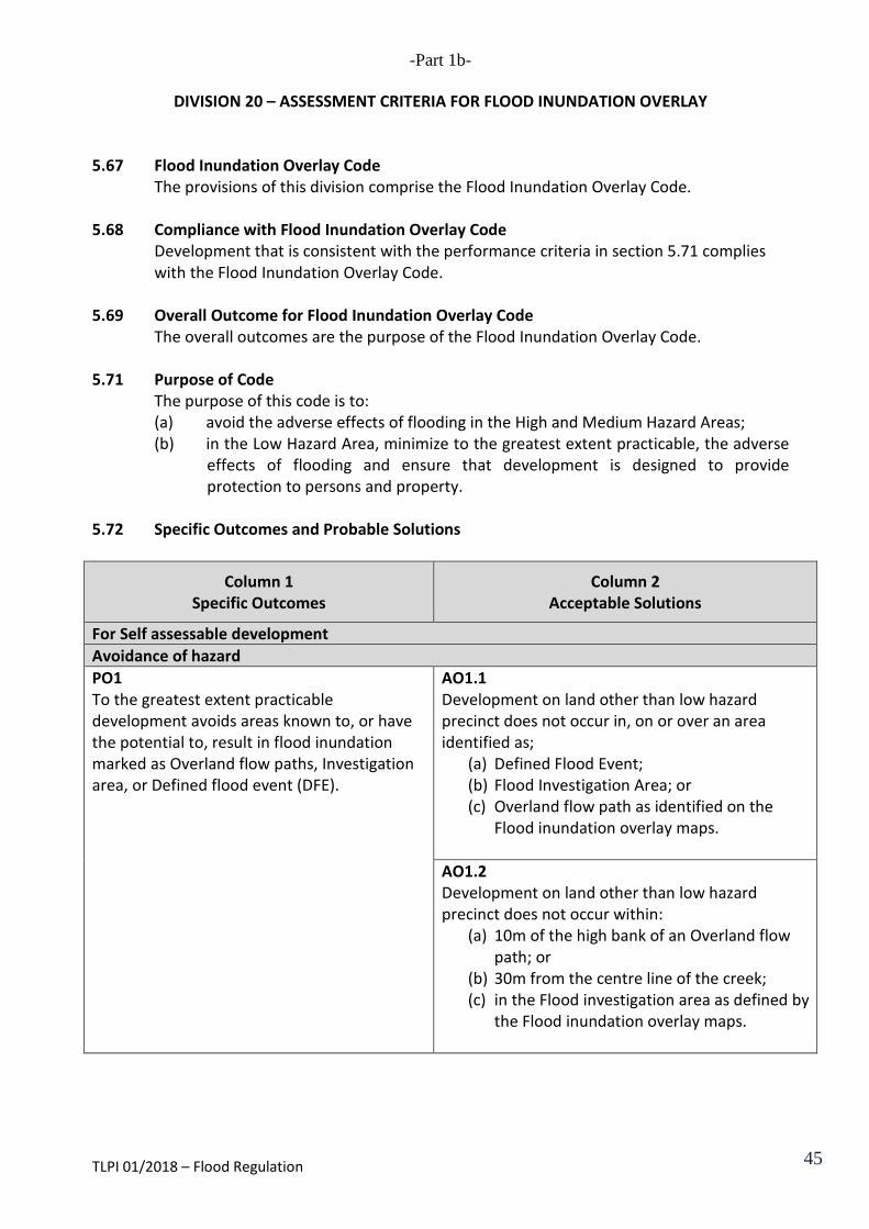
DIVISION 20 – ASSESSMENT CRITERIA FOR FLOOD INUNDATION OVERLAY
5.67 Flood Inundation Overlay Code The provisions of this division comprise the Flood Inundation Overlay Code.
5.68 Compliance with Flood Inundation Overlay Code
Development that is consistent with the performance criteria in section 5.71 complies with the Flood Inundation Overlay Code.
5.69 Overall Outcome for Flood Inundation Overlay Code
The overall outcomes are the purpose of the Flood Inundation Overlay Code. 5.71 Purpose of Code
The purpose of this code is to: (a) avoid the adverse effects of flooding in the High and Medium Hazard Areas; (b) in the Low Hazard Area, minimize to the greatest extent practicable, the
adverse effects of flooding and ensure that development is designed to provide protection to persons and property.
5.72 Specific Outcomes and Probable Solutions
Column 1 Specific Outcomes
Column 2 Acceptable Solutions
For Self assessable development Avoidance of hazard PO1 To the greatest extent practicable development avoids areas known to, or have the potential to, result in flood inundation marked as Overland flow paths, Investigation area, or Defined flood event (DFE).
AO1.1 Development on land other than low hazard precinct does not occur in, on or over an area identified as;
(a) Defined Flood Event (DFE); (b) Flood Investigation Area; or (c) Overland flow path as identified on the
Flood inundation overlay maps. AO1.2 Development on land other than low hazard precinct does not occur within:
(a) 10m of the high bank of an Overland flow path; or
(b) 30m from the centre line of the creek; (c) in the Flood investigation area as defined by
the Flood inundation overlay maps.
TLPI 01/2018 – Flood Regulation 31

-Part 1a-
For Self assessable and assessable development Low Hazard precinct PO2 In the Low hazard area, development that provides for vulnerable persons is avoided, but otherwise:
(a) minimises risk from the adverse effects of flood inundation to the greatest extent practicable;
(b) is designed so as to be capable of withstanding the static and dynamic loads, including debris loads, applicable in the Low hazard area; and
(c) access routes to and from the site and within the site are provided so that in a flood event, occupants can escape to a safe and secure area in accordance with current emergency management procedures.
Note— Applicants are advised to refer to the latest Queensland
Evacuation Guidelines for Disaster Management Groups for guidance on the process for evacuation planning and the latest Lockyer Valley Regional Council Disaster Management Plan – Evacuation Sub Plan.
AO2.1 The floor levels of any habitable room of a proposed building or extension to an existing building are a minimum of 300mm above the Defined flood level. AO2.2 The design and layout of residential development provides for:
(a) at ground level, parking of vehicles or storage of items that are capable of being moved in the event of flood; and
(b) habitable rooms above ground level. A2.3 The area below habitable rooms:
(a) is to be left open so as to not impede flood inundation;
(b) may be used for parking of vehicles or storage of items that are capable of being readily moved in the event of a flood; and
(c) are to be screened to a permeability of 50% so as not to impede the flow of flood inundation (e.g. using timber battens with a batten width gap between each batten).
AO2.4 Buildings and structures are sited on the highest part of the site to improve flood immunity. AO2.5 The finished surface level of any sewerage treatment system or openings into the sanitary drainage system is a minimum of 150mm above the Defined flood level. AO2.6 All proposed effluent land application areas that will be located below the Defined Flood level shall be treated to an advanced secondary quality. AO2.7 Development provides at least one road access to service the development which is capable of remaining passable for the purpose of emergency evacuations at a level higher than the Defined flood level.
TLPI 01/2018 – Flood Regulation 32
-Part 1a-
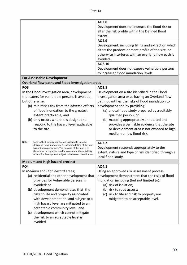
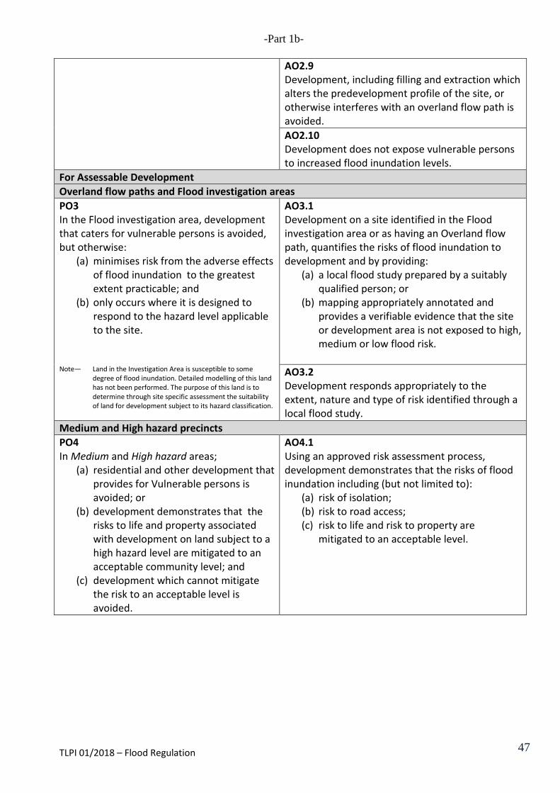
AO2.8 Development does not increase the flood risk or alter the risk profile within the Defined flood extent. AO2.9 Development, including filling and extraction which alters the predevelopment profile of the site, or otherwise interferes with an overland flow path is avoided. AO2.10 Development does not expose vulnerable persons to increased flood inundation levels.
For Assessable Development Overland flow paths and Flood investigation areas PO3 In the Flood investigation area, development that caters for vulnerable persons is avoided, but otherwise:
(a) minimises risk from the adverse effects of flood inundation to the greatest extent practicable; and
(b) only occurs where it is designed to respond to the hazard level applicable to the site.
Note— Land in the Investigation Area is susceptible to some
degree of flood inundation. Detailed modelling of this land has not been performed. The purpose of this land is to determine through site specific assessment the suitability of land for development subject to its hazard classification.
AO3.1 Development on a site identified in the Flood investigation area or as having an Overland flow path, quantifies the risks of flood inundation to development and by providing:
(a) a local flood study prepared by a suitably qualified person; or
(b) mapping appropriately annotated and provides a verifiable evidence that the site or development area is not exposed to high, medium or low flood risk.
AO3.2 Development responds appropriately to the extent, nature and type of risk identified through a local flood study.
Medium and High hazard precinct PO4 In Medium and High hazard areas;
(a) residential and other development that provides for Vulnerable persons is avoided; or
(b) development demonstrates that the risks to life and property associated with development on land subject to a high hazard level are mitigated to an acceptable community level; and
(c) development which cannot mitigate the risk to an acceptable level is avoided.
AO4.1 Using an approved risk assessment process, development demonstrates that the risks of flood inundation including (but not limited to):
(a) risk of isolation; (b) risk to road access; (c) risk to life and risk to property are
mitigated to an acceptable level.
TLPI 01/2018 – Flood Regulation 33
-Part 1b-
Temporary Local Planning Instrument – 01/2018 – Flood Regulation
Lockyer Valley Regional Council
Part 1(b) Laidley Shire Planning Scheme – Flood Regulation
TLPI 01/2018 – Flood Regulation 34
-Part 1b-
Short Title
1. This section of the temporary local planning instrument (TLPI) may be cited as Temporary Local Planning Instrument – Part 1(b) Laidley Shire Planning Scheme – Flood Regulation.
Purpose
2. The purpose of this TLPI is to: (a) provide improved flood regulation based on the identification of flood inundation
areas in the Laidley Shire Planning Scheme; and (b) ensure development and development activities appropriately respond to, or are
avoided in response to, the risk of flood hazard present on a site to protect life and property throughout the flood plain.
3. To achieve this purpose, the TLPI will affect the operation of the Laidley Shire Planning Scheme by: (a) introducing into Part 3, a new Desired Environmental Outcome about
development in flood inundated areas; (b) introducing Overlay Map: Map F which includes:
(i) Map F1 – which identifies (A) the Defined Flood Event (DFE); (B) Flood Investigation Areas; and (C) Overland flow path as identified on the Flood inundation maps;
and (ii) Map F2 – which identifies areas of High, Medium and Low Hazard within
the DFE; (c) amending the Assessment Criteria for Overlays to provide detailed criteria for
development in High, Medium and Low Hazard Areas; (d) varying other relevant provisions of the Laidley Shire Planning Scheme to give
effect to the revised flood inundation area and the identification of High, Medium and Low Hazard Areas.
(e) ensure that residential development and development which provides for Vulnerable persons is avoided where the risk of hazard is high;
(f) protect the safety of people and property without detriment to floodplain functions;
(g) identify, for the purposes of the Building Code of Australia and Queensland Development Code, a natural hazard management area for flood hazards;
(h) the type, scale and location of development on a site is responsive to the nature and risk of flood hazard present;
(i) ensure the mitigation of site flooding impacts does not alter, to an unacceptable level, the floodplain characteristics of the Defined Flood Event (DFE), within or external to, the development site;
(j) complimenting and supporting a multi-hazard approach to the risk management of natural hazards; and
(k) requiring that the DFE provides three hazard areas for flood natural hazard management areas;
TLPI 01/2015 – Flood Regulation
35

-Part 1b-
(i) High hazard area (ii) Medium hazard area (iii) Low hazard area
High hazard area (1) The purpose of the High hazard area is to identify land which after
formal risk assessment may pose unacceptable risks to life and property during the DFE.
(2) Flood behaviour characteristics defining this area are based on combinations of maximum water depth, velocity and velocity-depth over the range of events consider in formulating the DFE. Generally in this area: (a) major to extreme life risk is likely; (b) able bodied adults cannot safely walk; and (c) light frame buildings can structurally fail.
Medium hazard area (1) The purpose of the Medium hazard area is to identify land which after
formal risk assessment may pose a high risk to life and property during the DFE.
(2) Flood behaviour characteristics defining this area are based on combinations of maximum water depth, velocity and velocity-depth over the range of events consider in formulating the DFE. Generally in this area: (d) able bodied adults may not be able to safely walk; (e) cars can float and precautions must be taken; and (f) only large vehicles (trucks) may be able to safely travel.
Low hazard area (1) The purpose of the Low hazard area is to identify land which, after
application of the relevant mitigation actions described within this code are considered to pose any significant risk to life and property risk during the DFE.
(2) Flood behaviour characteristics defining this area are based on combinations or maximum water depth, velocity and velocity-depth over the range of events considered in formulating the DFE. Generally in this area: (a) no significant life risk; and (b) property is only at risk where exposed and in direct contact with
flood waters.
Flood investigation area (1) The purpose of the Flood investigation area is to identify land which is
known, or has the potential, to have some level of flood inundation, but
TLPI 01/2018 – Flood Regulation 36
-Part 1b-
due to limits in the modelling process has not yet been quantified. During a flood event, land in this area is exposed to a certain level of flood risk, although the determined level of risk has not been modelled.
(2) Development in this area must be supported by: (a) a Local flood study which investigates flooding on the site and:
(i) quantifies the hazard caused by flood, based on the area descriptions (i.e. High, Medium or Low hazard);
(ii) development must respond to the quantified risk of flood inundation appropriately based on the risk classification; and
(iii) development minimises the risk of flood by demonstrating compliance with the assessment criteria prescribed in Table 8.3.1.3.1—Assessable development; or
(c) mapping that is appropriately annotated and provides verifiable evidence that the site or development area is not exposed to flood inundation to a High, Medium or Low hazard.
Note— (a) The Flood inundation overlay map may also be used to trigger additional design requirements related to
flooding for building work assessable under the building assessment provisions, as set out in the Building Act 1975;
(b) The relevant building assessment provisions under the Building Act 1975 apply to all building work within the area identified on the Flood inundation overlay code and must take account of the flood potential within the area;
(c) Resilient building materials for use within the area on Flood inundation overlay maps should be determined in consultation with Council, in accordance with the relevant building assessment provisions; and
(d) Refer to the Dangerous Goods Safety Management Act 2001 and associated Regulation, the Environmental Protection Act 1994 and the relevant building assessment provisions under the Building Act 1975 for requirements related to the manufacture and storage of hazardous substances.
Application of the TLPI
4. This TLPI applies to: (a) the areas identified on Areas Map: Overlay Map F: Areas of Natural and
Environmental Significance – Flood Inundation Areas in the Laidley Shire Planning Scheme, and applies to the whole of the area of the former Laidley Shire;
(b) land affected by; (i) Defined Flood Event (DFE); (ii) Flood Investigation Area; or (iii) Overland flow path as identified on the Flood inundation overlay maps;
and (c) development that is assessing material change of use operational work /
building work / reconfiguring a lot.
5. The TLPI does not apply: (a) to development on the following lands (unless development provides for
Vulnerable persons): (i) Commercial zone; or (ii) Industrial zone; or
(b) where building works are for:
TLPI 01/2018 – Flood Regulation 37

-Part 1b-
(i) alterations to the floor area of an existing building; (ii) raising an existing building; (iii) repairing an existing building; (iv) adding an extra storey above an existing part of a building; or (v) class 10a or 10b structures when not used for storage of agricultural or
potentially hazardous chemicals.
Relationship with the Laidley Shire Planning Scheme
6. To the extent of any inconsistency between the Laidley Shire Planning Scheme and the TLPI, this TLPI prevails.
Duration of the TLPI 7. This TLPI has effect for a period of up one (1) year from the date of commencement or
until a new planning scheme for the Lockyer Valley Regional Council area takes effect.
Definitions
8. Unless otherwise defined in this TLPI or the Laidley Shire Planning Scheme, the terms used in this TLPI have the same meaning as defined in the Sustainable Planning Act 2009.
9. In this TLPI the following terms shall have the meanings below:
(a) “Additional Desired Environmental Outcome, Specific Outcomes and Acceptable Solutions” means the provision contained in Attachment 2B.
(b) “Defined Flood Level” means the flood level which the Council may from time to time determine.
(c) “Map F” means Revised Overlay Map F: Areas of Natural and Environmental Significance, Flood Inundation Area shown in Attachment 2A.
(d) “High Hazard Area” means the area on Map F identified as a High Hazard Area.
(e) “Medium Hazard Area” means the area of Map F identified as a Medium Hazard Area.
(f) “Low Hazard Area” means the area on Map F identified as a Low Hazard Area.
(g) "Overland Flow Paths" means any low-lying natural drainage paths or channel, open space floodway channels, road reserves, pavement expanses or any other flow paths that can convey flows of water
(h) “Tables 23B (Revised) and 24B (Revised)” means the provisions contained in Attachment 2B.
(i) “Vulnerable Persons” means persons whom are identified as having a high degree of susceptibility and low resilience to flood hazard, variously defined
TLPI 01/2018 – Flood Regulation 38
-Part 1b-
include: unaccompanied minors, the infirm, mentally and physically disabled and elderly and may include the following uses; child care centres, pre-schools, schools, hospitals, retirement homes and villages, nursing home or hospices.
Effect of this TLPI
10. This TLPI suspends the operation of the: (a) Provisions of the Laidley Planning Scheme identified in Attachment 2B.
(b) Desired Environmental Outcome 3.1(3)K in Part 3, Division 1, insofar as it relates to “flooding”;
(c) Overlay Map F: Areas of Natural and Environmental Significance, Flood Inundation Areas;
(d) Assessment Tables 23B and 24B in Part 5, Division 1; and
(e) The provisions contained in Part 6, Division 2 – Assessment Criteria for Overlays insofar as they relate to Flood Inundation Areas.
11. Development located on Map F and identified in Column 1 of Tables 23B (Revised) and 24B (Revised) on land identified as an area of flood hazard on Overlay Map F has:
(a) the level of assessment specified in Column 2; and
(b) must comply with the applicable codes in Column 3 and the Additional Desired Environmental Outcome, Specific Outcomes and Acceptable Solutions.
12. Map F of this TLPI represents Natural Hazard Management Areas (Flood) as defined in the State Planning Policy (SPP).
TLPI 01/2018 – Flood Regulation 39
-Part 1b-
Attachment 2A
REVISED OVERLAY MAP: AREAS OF NATURAL AND ENVIRONMENTAL SIGNIFICANCE, FLOOD INUNDATION AREA MAP F
TLPI 01/2018 – Flood Regulation 40

-Part 1b-
Attachment 2B
TABLE 23B (REVISED) Overlap Map F – Making a Material Change of Use (including associated works)
Column 1 Defined Use or Use Class
Column 2 Assessment Category
Column 3 Applicable Code
Agriculture Exempt if no building work proposed; Self Assessable if - class 10a or 10b structures and;
(c) used for storage of agricultural or potentially hazardous chemicals;
(d) complies with Self assessable criteria.
Code Assessable in all other circumstances
If Self Assessable – Flood Inundation Overlay Code If Code Assessable – Flood Inundation Overlay Code
Public Infrastructure Exempt if – development is not located within the DFE
Sport and Recreation Exempt if no building work proposed; Self Assessable if - class 10a or 10b structures and;
(c) used for storage of agricultural or potentially hazardous chemicals;
(d) complies with Self assessable criteria.
Code Assessable in all other circumstances
If Self Assessable – Flood Inundation Overlay Code If Code Assessable – Flood Inundation Overlay Code
Use for a Road Exempt in all Circumstances All Other Uses; except for the construction of Class 1b, 2, 3, class 10a or 10b structures when not used for storage of agricultural or potentially hazardous chemicals (as defined by the BCA)
Exempt if no building work proposed; Self Assessable if – development complies with the Self assessable criteria. Code Assessable in all other circumstances
If Self Assessable – Flood Inundation Overlay Code If Code Assessable – Flood Inundation Overlay Code
TLPI 01/2015 – Flood Regulation
41

-Part 1b-
TABLE 24B
Overlap Map F– Other Development
Column 1 Defined Use or Use Class
Column 2 Assessment Category
Column 3 Applicable Code
Reconfiguring a lot and/or Carrying out operational works for reconfiguring a lot
Code Assessable if the site area is located within an area identified as High Hazard, Medium Hazard or Low Hazard Areas
If Code Assessable – Flood Inundation Overlay Code
Carrying out building works; (c) not associated with a
material change of use; or
(d) class 10a or 10b structures when used for storage of agricultural or potentially hazardous chemicals
Self Assessable if – class; (d) 1a; or (e) 10 or 10b structures
and used for storage of agricultural or potentially hazardous chemicals; and
(f) complies with Self assessable criteria.
Code Assessable in all other circumstances
If Self Assessable – Flood Inundation Overlay Code If Code Assessable – Flood Inundation Overlay Code
Carrying out operational works for filling or excavating not associated with reconfiguring a lot or a material change of use
Code Assessable if – (c) the extent of cut or fill
exceeds 10m3 ; or (d) the site is located
within an area identified as High Hazard, Medium Hazard or Low Hazard Areas, except where the works are associated with bona fide operation of agricultural activities
If Code Assessable – Flood Inundation Overlay Code
Advertising Device, where not associated with a material change of use
Code Assessable if the site area is located within an area identified as High Hazard, Medium Hazard or Low Hazard Areas
If Code Assessable – Flood Inundation Overlay Code
Extracting Gravel, Rock, Sand or Soil, where not associated with a material change of use
Code Assessable if the site area is located within an area identified as High Hazard, Medium Hazard or Low
If Code Assessable – Flood Inundation Overlay Code
TLPI 01/2018 – Flood Regulation 42
-Part 1b-
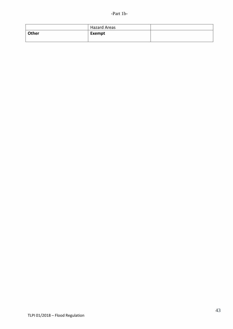
Hazard Areas Other Exempt
TLPI 01/2018 – Flood Regulation 43

-Part 1b-
Attachment 2C
Desired Environmental Outcome K
The adverse effects of flooding on development:
(c) in the High and Medium Hazard Areas are avoided;
(d) in the Low Hazard Area are minimised to the greatest extent practicable and development is designed to provide protection to persons and property.
TLPI 01/2018 – Flood Regulation 44
-Part 1b-
DIVISION 20 – ASSESSMENT CRITERIA FOR FLOOD INUNDATION OVERLAY
5.67 Flood Inundation Overlay Code The provisions of this division comprise the Flood Inundation Overlay Code.
5.68 Compliance with Flood Inundation Overlay Code
Development that is consistent with the performance criteria in section 5.71 complies with the Flood Inundation Overlay Code.
5.69 Overall Outcome for Flood Inundation Overlay Code
The overall outcomes are the purpose of the Flood Inundation Overlay Code. 5.71 Purpose of Code
The purpose of this code is to: (a) avoid the adverse effects of flooding in the High and Medium Hazard Areas; (b) in the Low Hazard Area, minimize to the greatest extent practicable, the adverse
effects of flooding and ensure that development is designed to provide protection to persons and property.
5.72 Specific Outcomes and Probable Solutions
Column 1 Specific Outcomes
Column 2 Acceptable Solutions
For Self assessable development Avoidance of hazard PO1 To the greatest extent practicable development avoids areas known to, or have the potential to, result in flood inundation marked as Overland flow paths, Investigation area, or Defined flood event (DFE).
AO1.1 Development on land other than low hazard precinct does not occur in, on or over an area identified as;
(a) Defined Flood Event; (b) Flood Investigation Area; or (c) Overland flow path as identified on the
Flood inundation overlay maps. AO1.2 Development on land other than low hazard precinct does not occur within:
(a) 10m of the high bank of an Overland flow path; or
(b) 30m from the centre line of the creek; (c) in the Flood investigation area as defined by
the Flood inundation overlay maps.
TLPI 01/2018 – Flood Regulation 45

-Part 1b-
For Self assessable and assessable development Low Hazard precinct PO2 In the Low hazard area, development that provides for vulnerable persons is avoided, but otherwise:
(a) minimises risk from the adverse effects of flood inundation to the greatest extent practicable;
(b) is designed so as to be capable of withstanding the static and dynamic loads, including debris loads, applicable in the Low hazard area; and
(c) access routes to and from the site and within the site are provided so that in a flood event, occupants can escape to a safe and secure area in accordance with current emergency management procedures.
Note— Applicants are advised to refer to the latest Queensland
Evacuation Guidelines for Disaster Management Groups for guidance on the process for evacuation planning and the latest Lockyer Valley Regional Council Disaster Management Plan – Evacuation Sub Plan.
AO2.1 The floor levels of any habitable room of a proposed building or extension to an existing building are a minimum of 300mm above the Defined flood level. AO2.2 The design and layout of residential development provides for:
(a) at ground level, parking of vehicles or storage of items that are capable of being moved in the event of flood; and
(b) habitable rooms above ground level. A2.3 The area below habitable rooms:
(a) is to be left open so as to not impede flood inundation;
(b) may be used for parking of vehicles or storage of items that are capable of being readily moved in the event of a flood; and
(c) are to be screened to a permeability of 50% so as not to impede the flow of flood inundation (e.g. using timber battens with a batten width gap between each batten).
AO2.4 Buildings and structures are sited on the highest part of the site to improve flood immunity. AO2.5 The finished surface level of any sewerage treatment system or openings into the sanitary drainage system is a minimum of 150mm above the Defined flood level. AO2.6 All proposed effluent land application areas that will be located below the Defined Flood level shall be treated to an advanced secondary quality. AO2.7 Development provides at least one road access to service the development which is capable of remaining passable for the purpose of emergency evacuations at a level higher than the Defined flood level. AO2.8 Development does not increase the flood risk or alter the risk profile within the Defined flood extent.
TLPI 01/2018 – Flood Regulation 46
-Part 1b- AO2.9 Development, including filling and extraction which alters the predevelopment profile of the site, or otherwise interferes with an overland flow path is avoided. AO2.10 Development does not expose vulnerable persons to increased flood inundation levels.
For Assessable Development Overland flow paths and Flood investigation areas PO3 In the Flood investigation area, development that caters for vulnerable persons is avoided, but otherwise:
(a) minimises risk from the adverse effects of flood inundation to the greatest extent practicable; and
(b) only occurs where it is designed to respond to the hazard level applicable to the site.
Note— Land in the Investigation Area is susceptible to some
degree of flood inundation. Detailed modelling of this land has not been performed. The purpose of this land is to determine through site specific assessment the suitability of land for development subject to its hazard classification.
AO3.1 Development on a site identified in the Flood investigation area or as having an Overland flow path, quantifies the risks of flood inundation to development and by providing:
(a) a local flood study prepared by a suitably qualified person; or
(b) mapping appropriately annotated and provides a verifiable evidence that the site or development area is not exposed to high, medium or low flood risk.
AO3.2 Development responds appropriately to the extent, nature and type of risk identified through a local flood study.
Medium and High hazard precincts PO4 In Medium and High hazard areas;
(a) residential and other development that provides for Vulnerable persons is avoided; or
(b) development demonstrates that the risks to life and property associated with development on land subject to a high hazard level are mitigated to an acceptable community level; and
(c) development which cannot mitigate the risk to an acceptable level is avoided.
AO4.1 Using an approved risk assessment process, development demonstrates that the risks of flood inundation including (but not limited to):
(a) risk of isolation; (b) risk to road access; (c) risk to life and risk to property are
mitigated to an acceptable level.
TLPI 01/2018 – Flood Regulation 47