location-based sample survey and census data …
TRANSCRIPT

Page 1 of 26
14th National Convention on Statistics (NCS) Crowne Plaza Manila Galleria, Quezon City
October 1-3, 2019
LOCATION-BASED SAMPLE SURVEY AND CENSUS DATA COLLECTION USING MODERN GIS PLATFORM
by
Florante C. Varona
For additional information, please contact:
Author’s name Florante C. Varona Designation Chief Statistical Specialist Affiliation Philippine Statistics Authority Address 17th Floor Cypebod Centris Three, cor. EDSA and Quezon Avenue,
Quezon City
Tel. no. 277-3733 E-mail [email protected]; [email protected]

Page 2 of 17
LOCATION-BASED SAMPLE SURVEY AND CENSUS DATA COLLECTION USING MODERN GIS PLATFORM
by
Florante C. Varona1
ABSTRACT
This paper aims to introduce map-based or location-based conduct of sample survey and census data collection using modern GIS Platform. This modern data collection approach will facilitate the integration of statistical information from surveys and censuses and the geospatial information to produce richer and meaningful insights and data analysis through the use of interactive dynamic maps and intelligent data visualization.
This paper attempts to present methods and procedures in conducting the map-
based survey approach using prototype from the census operation workflow intended specifically for the future conduct of 2020 Census of Population and Housing (CPH) and the 2022 Census of Agriculture and Fisheries (CAF) and other periodic sample surveys regularly conducted by the Philippine Statistics Authority (PSA). With the availability of digitized census maps and the on-going conduct of geo-tagging of buildings nationwide to develop digital building footprints, the possibility of using this vector information as point in the digitized map that represent building can be used to develop procedures that would substantially link the geo-tagged buildings to the survey/census enumeration units (i.e., housing unit, household, and individual). Generally, the process generates sampling unit information that contains both geospatial information (i.e., x and y coordinates) and survey/census data. To illustrate the methods and procedures of map-based data collection, this paper will use results and findings from the series of pretesting, mini-pilot census and pilot census conducted for the 2020 Census of Population and Housing (CPH). While the map-based data collection is intended to collect household and person level data, no individual information but only statistical summaries and aggregation will be released to the general public to ensure compliance with the data privacy act.
The map-based data collection using modern GIS technology will considerably
improve the statistical business processes of the Philippine Statistics Authority (PSA). The improvement will be realized in terms of quality and accuracy of survey/census results by addressing non-sampling error such as non-coverage and over-coverage. This can be done using real time GIS-based progress monitoring dashboard for supervisors for the early detection of coverage gaps and subsequently early field intervention to mitigate coverage problems. The timely release of survey/census results can be assured using the technology since data processing is already integrated in the technology-aided data collection using tablet device or Computer-Assisted Personal Interview (CAPI) system.
1. Introduction
The Philippine Statistics Authority (PSA) is mandated by law to carry out nationwide conduct of periodic surveys and censuses. The censuses that are regularly conducted by the PSA are the following: (1) Census of Population and Housing (CPH); (2) Census of Agriculture and Fisheries (CAF); and Census of Philippine Business and Industry (CPBI). The Census of Population and Housing (CPH) aims to gather basic information on demographic and socio-economic characteristics of the population selected important housing characteristics. The last Census of 1 Chief Statistical Specialist of Census Planning and Coordination Division (CPCD) of the National Censuses Service (NCS)

Page 3 of 17
Population (POPCEN) was conducted in 2015 while the next Census of Population and Housing (CPH) will be conducted next year, 2020. The Census of Agriculture and Fisheries (CAF) aims towards the collection and compilation of basic information on the agriculture and fishery sector of the country. The last agricultural census was in 2013, that is, the 2012 CAF. The next agricultural census, the 2022 CAF will be conducted in 2023. The Census of Philippine Business and Industry (CPBI) aims to collect and generate information on the levels, structure, and trends of economic activities of the Philippines. The last industry-based census, the 2012 CPBI, was conducted in 2013. The 2018 CPBI is being conducted this year, 2019.
The previous censuses in the Philippines were still conducted using the paper and pencil
personal interviewing (PAPI). This type of interview (PAPI) method, unlike computer-assisted personal interviewing (CAPI), does not require expertise in Information Technology (IT) to implement survey/census operations. However, the PSA’s survey data collection methods have substantially shifted to CAPI. The 2015 Global Adult Tobacco Survey used tablet-device in collecting data. The quarterly Labor Force Survey (LFS) had started to use CAPI since January 2017 survey round. The 2017 National Demographic and Health Surveys (NDHS) and the 2017 Listing of Farm Households (LFH) and the 2018 Updating of List of Establishments (ULE) were likewise implemented CAPI-based data collection.
While the Philippine Statistics Authority (PSA) had made some progress in modernizing data
collection method through the use of CAPI, the value of location or the application of “science of where” had only just started recently. Not so long ago, in 2016, the Environmental Systems Research Institute (ESRI) introduced the potential applications of modern Geographic Information System (GIS) platform in the statistical business processes of the PSA including that of sample surveys, censuses, and administrative-based data collection. The modern application of GIS allows integration of statistical and geospatial information maximizing the usefulness of collected data in communicating statistical results with dynamic geographic details.
This paper attempts to present methods and procedures in conducting the map-based
survey approach using prototype from the census operation workflow intended specifically for the future conduct of 2020 Census of Population and Housing (CPH) and the 2022 Census of Agriculture and Fisheries (CAF) and other periodic sample surveys regularly conducted by the Philippine Statistics Authority (PSA) in the future.
2. The GIS-Based Data Collection
With the availability of digitized census maps and the on-going conduct of geo-tagging of buildings nationwide to develop digital building footprints, the possibility of using this vector information as point in the digitized map that represent building can be used to develop procedures that would substantially link the geo-tagged buildings to the survey/census enumeration units (i.e., housing unit, household, and individual). Generally, the process generates geodatabase that contains both the geospatial information (i.e., x, y or longitude-latitude coordinates) and statistical information from survey and census data.
Page 4 of 17
3. The 5-year Rolling Program to Enhance the Digitized Census Maps
In order to fully utilize the application of GIS technology in preparation for the modernization of 2020 Census operation, the PSA initiated a 5-year rolling program starting from 2016 to 2020 to update and enhance the digitized census maps for the entire country. The 5-year rolling program to enhance the GIS-based census maps includes the following activities:
1. Conduct of field validation of master sample frame (MSF) for Household-Based Surveys in
2016 through:
a. Verification of selected primary sampling unit (PSU), barangay/ enumeration area (EA) boundaries
b. Determination of the actual location of the Secondary sampling units (SSU) using the Global Positioning System (GPS) waypoints or coordinates.
2. Conduct of tablet-aided geo-tagging of buildings to develop digitized building footprints from
2017 to 2019. 3. Conduct of Technology-aided EA delineation from digitized census maps in 2019 in
preparation for the development of enumeration area (EA) reference file for the 2020 CPH
4. Conduct the 2020 Census of Population and Housing (CPH) using tablet device incorporating digitized building footprints to link geo-referenced spatial information with census statistical information
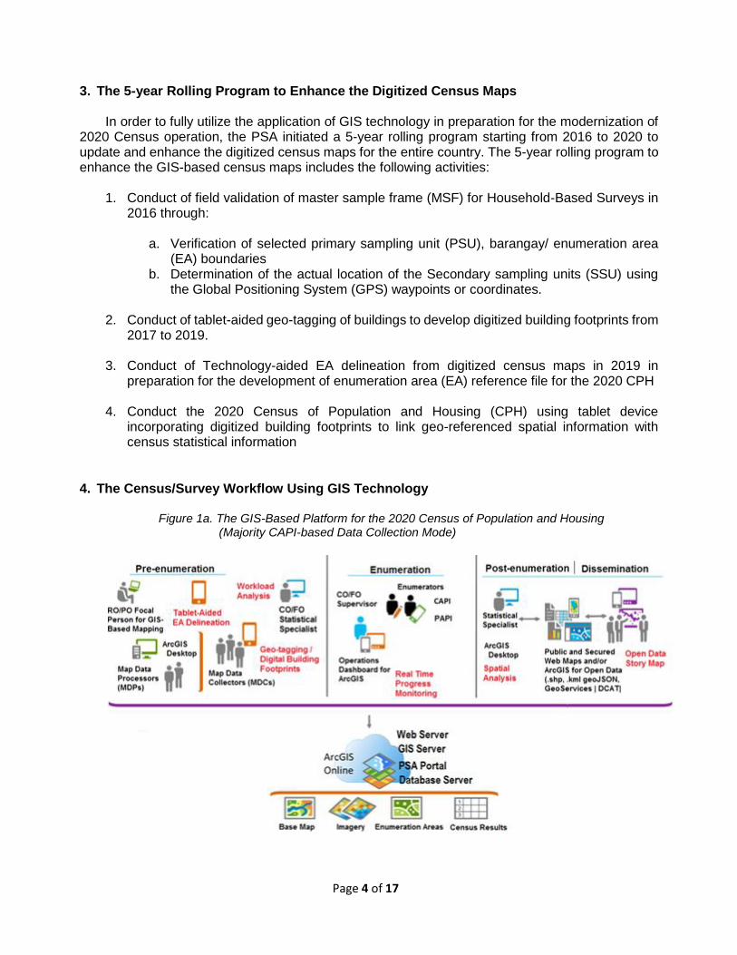
4. The Census/Survey Workflow Using GIS Technology
Figure 1a. The GIS-Based Platform for the 2020 Census of Population and Housing (Majority CAPI-based Data Collection Mode)

Page 5 of 17
The GIS-based platform for the 2020 census workflow introduced for the first time a map-based or location-based census operation with real-time progress monitoring using GIS-based operations dashboard. The platform as illustrated in Figure 1a presented an end-to-end GIS solution from pre-enumeration, actual conduct of census operation of which majority using CAPI-based data collection mode, and up to the dissemination of results.
Figure 1b. The GIS-Based Platform for the 2020 Census of Population and Housing (PAPI-based Data Collection Mode)
On the other hand, if CAPI-based data collection mode is not feasible because of limited resources to purchase the required number of tablet device (i.e., about 120,000 tablet units for the 2020 CPH), then the platform presented in Figure 1b would now include the preparation and printing of census maps for PAPI-based data collection.
The GIS-based solution at this point, will then be reduced to the pre-enumeration and post-
enumeration only. In the PAPI-based process it will become more challenging to integrate geospatial information (i.e., geo-point of building) to the census information since the enumerator will rely on the updates incorporated in the printed census map of the assigned enumeration area. These census maps will still undergo processing to reflect updates such as new buildings and subsequently integrate with census data using the Building Serial Number (BSN) as common variable for both geospatial information and census data.
The integration of GIS technology in the conduct of survey/census data collection can facilitate the application of spatial analysis and intelligent data visualization using dynamic maps. The integration of geospatial and survey/census data can lead to the full modernization of statistical business processes for the PSA.
Page 6 of 17
5. Geo-tagging of Buildings
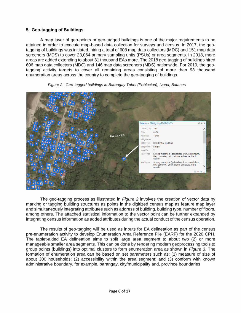
A map layer of geo-points or geo-tagged buildings is one of the major requirements to be attained in order to execute map-based data collection for surveys and census. In 2017, the geo-tagging of buildings was initiated, hiring a total of 608 map data collectors (MDC) and 151 map data screeners (MDS) to cover 23,064 primary sampling units (PSUs) or area segments. In 2018, more areas are added extending to about 31 thousand EAs more. The 2018 geo-tagging of buildings hired 606 map data collectors (MDC) and 146 map data screeners (MDS) nationwide. For 2019, the geo-tagging activity targets to cover all remaining areas consisting of more than 93 thousand enumeration areas across the country to complete the geo-tagging of buildings.
Figure 2. Geo-tagged buildings in Barangay Tuhel (Poblacion), Ivana, Batanes
The geo-tagging process as illustrated in Figure 2 involves the creation of vector data by
marking or tagging building structures as points in the digitized census map as feature map layer and simultaneously integrating attributes such as address of building, building type, number of floors, among others. The attached statistical information to the vector point can be further expanded by integrating census information as added attributes during the actual conduct of the census operation.
The results of geo-tagging will be used as inputs for EA delineation as part of the census
pre-enumeration activity to develop Enumeration Area Reference File (EARF) for the 2020 CPH. The tablet-aided EA delineation aims to split large area segment to about two (2) or more manageable smaller area segments. This can be done by rendering modern geoprocessing tools to group points (buildings) into optimal clusters to form enumeration area as shown in Figure 3. The formation of enumeration area can be based on set parameters such as: (1) measure of size of about 300 households; (2) accessibility within the area segment; and (3) conform with known administrative boundary, for example, barangay, city/municipality and, province boundaries.

Page 7 of 17
Figure 3. Density-Based Clustering of geo-tagged buildings in Basco, Batanes
6. Map-based Data Collection Using CAPI
The ArcGIS platform developed by Environmental Systems Research Institute (ESRI) is a GIS-based integrated system that aims to satisfy specific statistical business process needs. During the conduct of map-based census enumeration using Computer-Assisted Personal Interviewing (CAPI), a GIS-based application can be used to collect data from the tablet-device as shown in Figure 4. The data has to be synchronized to the portal server of which progress can be monitored using operations dashboard.
Figure 4. Map-based Census Workflow Using CAPI

Page 8 of 17
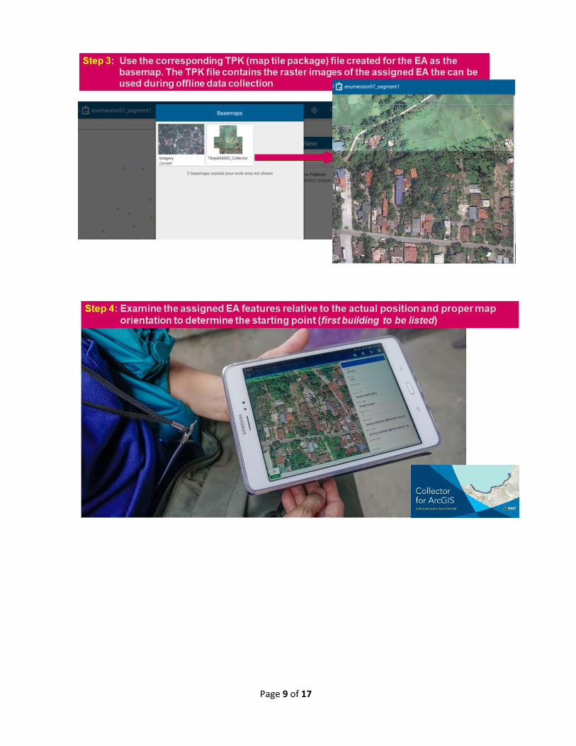
Figure 5 demonstrates the major steps in conducting map-based or location-based census operation as applied during the series of pretests for the 2020 Census of Population and Housing in selected barangays:
Figure 5. Map-based Census Workflow Using CAPI
Page 9 of 17

Page 10 of 17

Page 11 of 17

Page 12 of 17

Page 13 of 17
GIS-based Operations Dashboard
During the actual conduct of map-based census operation using CAPI, the GIS-based operations dashboard (Figure 6) can be used by census supervisors (i.e., team supervisors, field offices supervisors and central office supervisors) for real-time progress monitoring for quality assurance and early detection of coverage gaps and timely intervention to address field operation problems.
Figure 6. View of operations dashboard during the conduct of CPH Pretest 4 in Malolos Bulacan
7. Map-based Data Collection Using PAPI
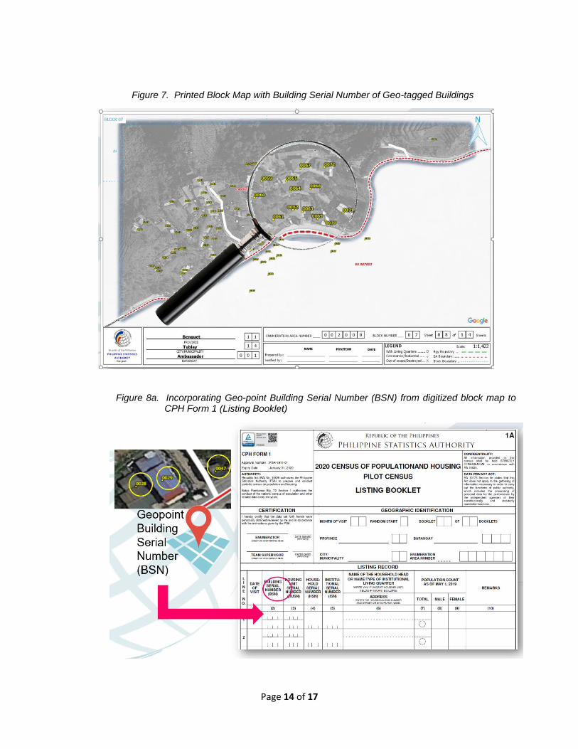
In a map-based data collection using PAPI, the enumerator will rely on the printed census
enumeration area (EA) maps and digitized block maps incorporating the printed Building Serial Number (BSN) assigned to geo-points collected during the geo-tagging of buildings activity. Figure 6 presents an example of block map to be used by the enumerator as reference during the map-based data collection for the 2020 CPH using PAPI. In this process, the enumerator will indicate in the listing booklet (CPH Form 1) the Geo-point BSN of geo-tagged building in the area as shown in the printed block map during the actual data collection (Figure 7a). Even using PAPI mode of data collection, the geospatial information (i.e., x, y coordinates) of the geo-point of the building can still be integrated with census data from processed CPH Form 2 or CPH Form 3 using the corresponding Geo-tagged building BSN listed in the CPH Form 1 (Figure 7b).
Page 14 of 17
Figure 7. Printed Block Map with Building Serial Number of Geo-tagged Buildings
Figure 8a. Incorporating Geo-point Building Serial Number (BSN) from digitized block map to CPH Form 1 (Listing Booklet)

Page 15 of 17
Figure 8b. Integrating X Y coordinates of the geo-point of the building listed in CPH Form 1 (listing booklet) to the census data information from CPH Form2 (Common Household Questionnaire) or CPH Form 3 (Sample Household Questionnaire)
Figure 9. Map-based Census Workflow Using PAPI

Page 16 of 17
8. Post-Enumeration/Dissemination The integrated geospatial data and statistical information from surveys/census can be stored
and managed using the census geodatabase. This allows application of more dynamic dissemination techniques of which data, which has geographical or spatial aspect, can be presented differently using story maps, web maps, web apps and other map-based intelligent data visualization using census as an open data source.
While census taking is intended to collect person level data, no individual information but
only in statistical summaries and aggregation can be disseminated or publicly released to ensure compliance to the data privacy act.
9. Conduct of pretesting for the map-based data collection
The Philippine Statistics Authority (PSA) conducted series of pretests to simulate map-based
or location-based census operations. The team from National Censuses Service (NCS) in collaboration with the Geospatial Mapping Unit of Information Technology and Dissemination Service (ITDS) conducted the following series of pretests in selected areas in the Philippines
Map-based data Collection using CAPI
• Pretest 1: Manila and San Juan (September 2017)
• Pretest 2: Palawan and Guimaras (October 2017)
• Pretest 3: Pampanga (November 2017)
• Pretest 4: Bulacan (April 2018)
• Pretest 5: Batangas (June 2018)
• Mini Pilot Census: Janiuay, Iloilo (October 2018)
• Pilot Census in Eight (8) Selected Areas in the Philippines (20 May to 17 June 2019)
Map-based data Collection using PAPI
• Pretest 6: Rodriguez, Rizal (September 2019)
The conduct of pretests aims to test the efficiency and effectiveness of GIS Systems in handling map-based census operations using both the paper and pencil personal interviewing (PAPI) and the computer-assisted personal interviewing (CAPI) methods of data collection. The results obtained from pretesting activities facilitate the improvement in integrating the GIS application systems with the census operational workflows including that of the development of real-time progress monitoring using a customized GIS-based operations dashboard.
Page 17 of 17
10. Recommendations
The map-based survey and census operation using the modern GIS technology combined with CAPI mode of data collection will considerably improve the statistical business processes of the Philippine Statistics Authority (PSA). The improvement will be in terms of accuracy by addressing non-sampling error such as non-coverage and over-coverage. This can be done using real time GIS-based progress monitoring dashboard for supervisors for the early detection of coverage gaps and subsequently early field intervention to mitigate coverage problems. The timely release of survey and census results can be assured using the technology since data processing is already integrated in the technology-aided data collection using tablet device.
The following are recommendations to further improve and modernize not only the conduct
of census in the Philippines using map-based approach but also for the other statistical business processes of the Philippine Statistics Authority including that of periodic sample surveys and data collection from administrative-based data sources:
1. To embrace innovative and transformative solutions through full implementation of GIS
Technology, specifically, modern GIS Software to create dynamic and interactive digital maps for a map-based data dissemination of survey/census results, the GIS Enterprise to facilitate the development of PSA GIS Cloud and/or Portal/Server as back-end of client-server model for technology-aided data collection in the conduct of surveys and censuses, and the enhanced GIS-based Survey Apps, Map Data Collector Apps, and GIS-based monitoring dashboard as the front end of tablet-aided data collection;
2. To consider a long-term investment in GIS technology that can be fully applied in our statistical business processes by entering into GIS Enterprise Agreement with the leading GIS Software Industry and the subsequent procurement of GIS-ready infrastructures (servers, desktops, laptops, tablet devices, high-speed and stable internet service provider) to fully enhance and modernize statistical operations of the Philippine Statistics Authority (PSA); and
3. To continue adopting innovative GIS applications and techniques in statistical and administrative-based processes of the PSA for a continual development plan of PSA Personnel with by conducting series of GIS trainings, developing GIS-based projects, and participating in local and international fora, and attemding meeting concerning GIS technology development.