local to regional adaptation and mitigation strategiesconference.ifas.ufl.edu/cimr/cimr program with...
TRANSCRIPT

Local to Regional Adaptation and Mitigation Strategies
May 24-27, 2011 Orlando, Florida
www.conference.ifas.ufl.edu/CIMR
Hosted by


Dear CIMR Participants, Welcome to “Climate Information for Managing Risks – Local to regional adaptation and mitigation strategies.” We pronounce CIMR “simmer” because things are heating up in the area of climate science and its application. The first CIMR Symposium was held in June 2008 and emphasized partnerships and solutions for agriculture and natural resources. We were particularly concerned with building partnerships that integrate research, teaching, and outreach. Though there were many positive outcomes from CIMR 2008, we are particularly proud of two: The Florida Climate Institute and the Agricultural Modeling Inter-comparison and Improvement Project (AgMIP), both of which you will learn more about during the Symposium. The Program Committee organized CIMR 2011 around sectors that are vulnerable to risks posed by climate variability and climate change, namely: agriculture, water resources, costal and urban communities, biodiversity and conservation of natural ecosystems, and public health. Additional themes include: cross-sector climate impacts, developing climate scenarios for planning, and land use and land cover interactions with climate. On day one of CIMR 2011, Chet Koblinsky, Executive Director of the NOAA Climate Program will give our opening keynote address following which we will hear from leading experts on these themes who will give us their perspectives on the challenges and opportunities for local and regional adaptation and climate change mitigation faced by the different sectors and themes. We will also have a poster session and reception during the evening. On day two, we will have concurrent panel discussions that address specific projects under each of the themes. The intent of these sessions is to promote discussions and to identify needs and opportunities for developing new collaborations. On day three, we will hear reports from the Program Committee members who participated in organizing the panel discussions and a closing key note address from Steven Shafer, Deputy Administrator of the USDA Agricultural Research Services. As well as bringing you experts from around the country in the field of climate science and application of climate science to solving urgent problems, the Program Committee has attempted to provide you many opportunities for networking, discussion, and development of new partnerships. We look forward to your active participation in CIMR 2011. Mark R. McClellan Keith T. Ingram James W. Jones Dean for Research Chair, Program Committee Director, Florida Director, Florida Agricultural Coordinator, Southeast Climate Institute Experiment Station Climate Consortium
May 24-27, 2011 • Orlando, FL
Local to Regional Adaptation and Mitigation Strategies

Climate Information for Managing Risks (CIMR): Local to Regional Adaptation and Mitigation Strategies
2
May 24-27, 2011 • Orlando, FL
3
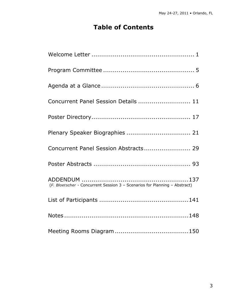
Table of Contents
Welcome Letter ..................................................... 1
Program Committee ............................................... 5
Agenda at a Glance ................................................ 6
Concurrent Panel Session Details ........................... 11
Poster Directory ................................................... 17
Plenary Speaker Biographies ................................. 21
Concurrent Panel Session Abstracts ........................ 29
Poster Abstracts .................................................. 93
ADDENDUM ....................................................... 137 (F. Bloetscher - Concurrent Session 3 – Scenarios for Planning – Abstract)
List of Participants .............................................. 141
Notes ................................................................ 148
Meeting Rooms Diagram ...................................... 150

Climate Information for Managing Risks (CIMR): Local to Regional Adaptation and Mitigation Strategies
4

May 24-27, 2011 • Orlando, FL
5
Program Committee
Alison Adams Tampa Bay Water Eric Chassignet FSU, Center for Ocean-Atmospheric Prediction Studies (COAPS), Florida Climate Institute Mary Duryea UF, IFAS, Office of Dean for Research and the Florida Agricultural Experiment Station Joan Dusky UF, IFAS, Office of Dean for Extension and Florida Cooperative Extension Office Wendy Graham UF Water Institute Jerry Hatfield USDA, Agriculture Research Service John Hayes UF, IFAS, Wildlife Ecology and Conservation Radley Horton Columbia University, NASA Goddard Institute for Space Studies
Keith Ingram Southeast Climate Consortium UF, IFAS Agricultural and Biological Engineering
Jim Jones UF, IFAS, Dept. of Agricultural and Biological Engineering, Florida Climate Institute Glenn Morris Emerging Pathogen Institute UF, College of Medicine Ray Motha USDA, Office of the Chief Economist (OCE) Victor Murphy NOAA, National Weather Service, Southern Region Headquarters Jim O'Brien FSU, Center for Ocean-Atmospheric Prediction Studies (COAPS) Adam Parris NOAA's Climate Program Office Louie Tupas USDA, NIFA, Division of Global Climate Change Steve Zebiak Columbia University, IRI Climate and Society

Climate Information for Managing Risks (CIMR): Local to Regional Adaptation and Mitigation Strategies
6
Agenda at a Glance Tuesday, May 24, 2011
4:00pm-7:00pm Symposium Registration Open [Caribbean Registration Desk] Poster Presenters setup Posters [Caribbean IV/V]
5:00pm-7:00pm Early Bird Social [Boca Patio]
Wednesday, May 25, 2011
7:30am-8:30am Morning Refreshments [Caribbean IV/V]
7:30am-5:30pm Symposium Registration Open [Caribbean Registration Deskl]
8:30am-10:00am Opening Plenary Session [Caribbean VI/VII]
Opening Remarks Moderator: Keith Ingram, Coordinator, Southeast Climate Consortium, Dept. of Agri. and Biological Eng., IFAS, UF, Gainesville, FL
Welcome Jim Jones, Distinguished Professor, Dept. of Agricultural and Biological Engineering, IFAS, Director, Florida Climate Institute, UF, Gainesville, FL
Welcome Mark R. McLellan, Dean for Research, IFAS, UF, Gainesville, FL
Introduction of Keynote Speaker James O'Brien, Emeritus Robert 0. Lawton Distinguished Professor, Center for Ocean-Atmospheric Prediction Studies, FSU, Tallahassee, FL
Keynote Address: Climate Science and Service from Local to Global Scales Chester Koblinsky, Executive Director, Climate Program Office, Office of Oceanic and Atmospheric Research, NOAA, Silver Spring, MD
10:00am-10:30am Break
10:30am-12:00pm Plenary Session
Moderator: Eric Chassignet, Director, Center for Ocean-Atmospheric Prediction Studies, Co-Director, Florida Climate Institute, FSU, Tallahassee, FL
Scenarios for Planning Holly Hartmann, Director, Arid Lands Information Center, University of Arizona, Tucson, AZ
Water Resources David Yates, National Center for Atmospheric Research, Boulder, CO
Coastal and Urban Communities Margaret Davidson, Director, NOAA Coastal Services Center, Charleston, SC
12:00pm-1:15pm Lunch - provided [Caribbean IV/V]
1:15pm-2:45pm Plenary Session
Moderator: Joan Dusky, Associate Dean and Professor, Office of Dean for Extension and Florida Cooperative Extension Office, IFAS, UF, Gainesville, FL
Biodiversity and Conservation Jean Brennan, Coordinator, Appalachian LLC, US Fish and Wildlife Service, Blacksburg, VA
Agricultural Risk Management Cynthia Rosenzweig, Senior Research Scientist, NASA Goddard Institute for Space Studies, New York, NY
Cross-sectoral Impacts Kenneth Mitchell, Special Assistant to the Director, Air, Pesticides, and Toxics Management Division, U.S. EPA, Atlanta, GA

May 24-27, 2011 • Orlando, FL
7
Wednesday, May 25, 2011 (continued)
2:45pm-3:15pm Break [Caribbean IV/V]
3:15pm-5:15pm
Plenary Session
Moderator: Glenn Morris, Director, Emerging Pathogen Institute, UF, Gainesville, FL
Public Health and Climate George Luber, Associate Director for Climate Change, Division of Environmental Hazards and Health Effects, NCEH, CDC, Atlanta, GA
Miami-Dade: A Case Study on Adaptation and Mitigation Nichole Hefty, Coordinator, Miami-Dade County Climate Change, Miami-Dade Department of Environmental Resources Management, Miami, FL
Poster Presentations - a brief introduction
5:30pm-7:00pm Poster Session & Reception [Caribbean IV/V]
Thursday, May 26, 2011
7:00am-8:00am Morning Refreshments [Caribbean IV/V]
7:00am-5:00pm Symposium Registration Open [Caribbean Registration Desk]
8:30am-10:00am
Concurrent Panel Sessions
Session 1 Managing Risks to Agriculture—A World Perspective [Boca I/II]
Session 2 Water Resource Management
[Boca III]
Session 3 Scenarios for
Planning [Boca IV]
Moderator: Gerald Arkin
Moderator: Alison Adams
Moderator: Vasubandhu Misra
Dineshkumar Moghariya Farmers' Perceptions of Risk,
Impacts and Adaptations to Climate Change: A Perspectives from
Western India
David Yates Climate Change in Water Utility
Planning: Decision Analytic Approaches
John Promise Addressing Climate Risks in North Texas' Preferred
Future
Carrie Furman Climate Services for Vulnerable
Communities: Listening to African American Farmers
Pamela Knox Predicting Georgia's Future Water
Use Using Climatological and Sociological Factors
Wendy-Lin Bartels Evolution of Social
Science Methods for Climate Adaptation
Research and Assessment
Richard McNider Migration of Agriculture to the Southeast as an Adaptation to
Regional Climate Change
Tirusew Asefa Performance Evaluation of a
Water Resources System under Varying Climatic Conditions:
Reliability, Resilience, Vulnerability and Beyond
Frederick Bloetscher Impact on Local
Community Infrastructure from Sea
Level Rise
Shane Perkins Potential Usefulness of Climate Forecasts and AgroClimate for Agriculture in South Carolina
Stephen McGrew Making of a Green Utility -
Environmental Stewardship
Discussion Discussion Discussion
10:00am-10:30am Break

Climate Information for Managing Risks (CIMR): Local to Regional Adaptation and Mitigation Strategies
8
Thursday, May 26, 2011 (continued)
10:30am-12:00pm
Concurrent Panel Sessions
Session 1 Managing Risks to Agriculture
– Tools for Understanding [Boca I/II]
Session 2 Water Resource
Management: Tools and Analysis [Boca III]
Session 3 Cross-sector
Impacts [Boca IV]
Moderator: Gerald Arkin
Moderator: Alison Adams
Moderator: Caitlin Simpson
DW Shin Climate Model Evaluation Tools -
Crop Models
Vaishali Sharda Development of Community
Water Deficit Index (CWDI) for Small to Mid-size Communities
of the Southeastern United States
Radley Horton Cross-sector Climate
Impacts and Adaptation Strategies in the New York City Infrastructure-shed
Kenneth Boote Risk and Uncertainty in Crop Model Predictions of Regional
Yields under Climate Change and Variability
Michael Maddox Agricultural Decision System for the Chesapeake Bay Forecasting
System
Denis Nadolnyak Climate Impacts on Agricultural Loan
Performance: Evidence from the Southeastern US
Mark Boudreau The Importance of Scale in Managing Agricultural Risk
through Climate Information
Mark Brooks Development of a Turfgrass
Irrigation Management System for North Carolina
Tamara Houston Sectoral Engagement
Activities at NOAA's National Climatic Data Center
Teddy Allen The International Environmental
Data Rescue Organization: history, present, and future
Shimelis Setegn Climate change trend and its impact on the hydrological processes in the Caribbean
islands of Puerto Rico, Jamaica and Dominican Republic
Suresh Sharma Incorporating Seasonal to Inter-annual (SI) Climate Variability in Point Source Discharge Permitting for
Effective TMDL Development and Implementation
Discussion Discussion Discussion
12:00pm-1:30pm Lunch - provided [Caribbean IV/V]
1:30pm-3:00pm
Concurrent Panel Sessions
Session 1 Managing Risks to Agriculture –
Indirect Effects [Boca I/II]
Session 2 Coastal and Urban Communities: Sea Level Rise Impacts [Boca III]
Moderator: Gerald Arkin
Moderator: Radley Horton
Gail Wilkerson Influence of ENSO Phase on Optimal Corn
Planting Dates in North Carolina
Md. Rashed Chowdhury Rising Sea Level and the Vulnerable Coastal Communities in the U.S.-
Affiliated Pacific Islands
Brenda Ortiz Effect of Rainfall and Maximum Temperature
on Corn Aflatoxin Contamination in the Southeastern U.S. Coastal Plain
Frederick Bloetscher Fighting Water with Water:
Counteracting the Impacts of Sea Level Rise on South Florida Waters
Santiago Meira Yield Forecasting: An Approach Using Crop
Simulation Models
Ajita Atreya Flood Risk and Risk Perception: Evidence from Property Prices in
Georgia
Discussion
Tara McCue GIS Sea Level Rise Vulnerability
Assessment
Discussion
3:00pm-3:30pm Break
May 24-27, 2011 • Orlando, FL
9
Thursday, May 26, 2011 (continued)
3:30pm-5:00pm
Concurrent Panel Sessions
Session 1 Biodiversity and
Conservation in Natural Ecosystems [Boca IV]
Session 2 Coastal and Urban
Communities: Policy Planning and Adaptation
[Boca III]
Session 3 Land Use and Land Cover
Changes [Boca I/II]
Moderator: John Hayes
Moderator: Adam Parris
Moderator: Jim Jones
Juan Alba Landa Forest Diversity and its
Conservation
Randall Parkinson Assessing Municipal Vulnerability to Predicted Sea Level Rise: City
of Satellite Beach, FL
Vasubandhu Misra Anthropogenic influence on Climate over the Southeast
United States
Doug Parsons Current Efforts and Future
Directions: A state agency's approach to climate change
John Fergus Sea Level Rise at the Local Government Level: Lessons
Learned
John Christy Summer 2010 Heat in SE
USA - Was It Really a Record?
MD Abdus Salam Climate Change and Fisheries in
Bangladesh: Impact and Adaptation
Whitney Gray Southwest Florida Plans for
Climate Change
Laura Geselbracht Modeling Sea Level Rise
Impacts on Coastal Wetlands at Gulf of Mexico Estuaries
Tom Hoctor Large-scale Implications of SLR
on Conservation Priority Areas in Florida
Carlton Hall Climate Change Projections and Adaptation Strategies for Multi-Objective Resource Management
at Kennedy Space Center, Florida
Guzine El Diwani Feasibility Study of Biodiesel
from Jatropha in Egypt
Discussion Discussion Discussion
Climate Information for Managing Risks (CIMR): Local to Regional Adaptation and Mitigation Strategies
10
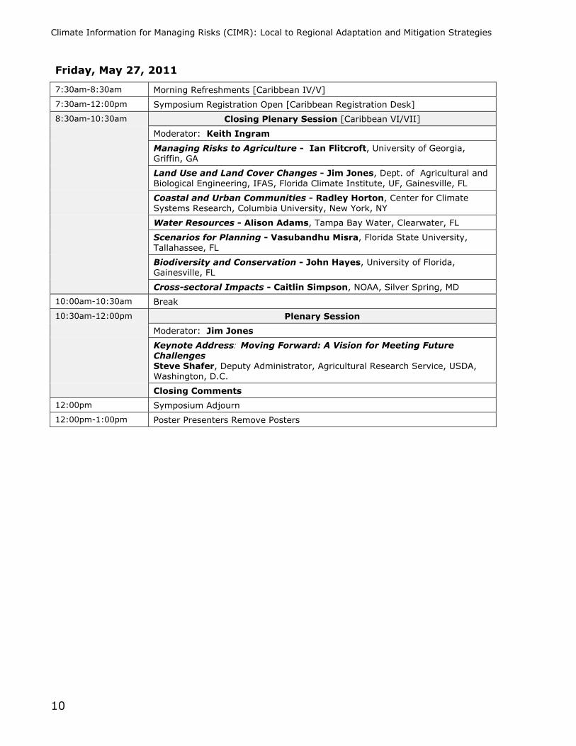
Friday, May 27, 2011
7:30am-8:30am Morning Refreshments [Caribbean IV/V]
7:30am-12:00pm Symposium Registration Open [Caribbean Registration Desk]
8:30am-10:30am Closing Plenary Session [Caribbean VI/VII]
Moderator: Keith Ingram
Managing Risks to Agriculture - Ian Flitcroft, University of Georgia, Griffin, GA
Land Use and Land Cover Changes - Jim Jones, Dept. of Agricultural and Biological Engineering, IFAS, Florida Climate Institute, UF, Gainesville, FL
Coastal and Urban Communities - Radley Horton, Center for Climate Systems Research, Columbia University, New York, NY
Water Resources - Alison Adams, Tampa Bay Water, Clearwater, FL
Scenarios for Planning - Vasubandhu Misra, Florida State University, Tallahassee, FL
Biodiversity and Conservation - John Hayes, University of Florida, Gainesville, FL
Cross-sectoral Impacts - Caitlin Simpson, NOAA, Silver Spring, MD
10:00am-10:30am Break
10:30am-12:00pm Plenary Session
Moderator: Jim Jones
Keynote Address: Moving Forward: A Vision for Meeting Future Challenges Steve Shafer, Deputy Administrator, Agricultural Research Service, USDA, Washington, D.C.
Closing Comments
12:00pm Symposium Adjourn
12:00pm-1:00pm Poster Presenters Remove Posters

May 24-27, 2011 • Orlando, FL
11
Concurrent Panel Session Details
Thursday, May 26, 2011 — 8:30AM-10:00AM
Session 1: Managing Risks to Agriculture—A World Perspective [Boca I/II; Session Abstracts: Page 29] Moderator: Gerald Arkin, University of Georgia, Griffin, GA Farmers’ Perceptions of Risk, Impacts and Adaptations to Climate Change: A Perspective from Western India − Dineshkumar Moghariya and Richard C. Samrdon; Department of Environmental Studies, State University of New York College of Environmental Science and Forestry, Syracuse, NY, USA
Climate Services for Vulnerable Communities: Listening to African American Farmers − Carrie Furman1, Carla Roncoli2, Wendy-Lin Bartels3, Mark Boudreau1, Heather Gray4 and Gerrit Hoogenboom5; 1Department of Biological and Agricultural Engineering, University of Georgia, Athens, GA USA; 2Master's in Development Practice, Emory University, Atlanta, GA USA; 3Department of Agricultural Education and Communication, University of Florida, Gainesville FL USA; 4Federation of Southern Cooperatives, Atlanta, GA USA; 5AgWeatherNet, Washington State University, Prosser, WA USA
Migration of Agriculture to the Southeast as an Adaptation to Regional Climate Change − Richard T. McNider, John R. Christy and Cameron Handyside; Earth System Science Center, University of Alabama in Huntsville, Huntsville, AL, USA
Potential Usefulness of Climate Forecasts and AgroClimate for Agriculture in South Carolina − M. Shane Perkins1, S. Templeton1, H. Dinon2, B. Lassiter3 and J. Whitehead4; 1Department of Applied Economics and Statistics, Clemson University, Clemson, SC, USA; 2State Climate Office of North Carolina, North Carolina State University, Raleigh, NC, USA; 3 Crop Science Department, North Carolina State University, Raleigh, NC, USA; 4South Carolina Sea Grant Consortium, Charleston, SC, USA
Session 2: Water Resource Management [Boca III; Session Abstracts: Page 35] Moderator: Alison Adams, Tampa Bay Water, Clearwater, FL Climate Change in Water Utility Planning: Decision Analytic Approaches − David Yates; National Center for Atmospheric Research (NCAR), Boulder, CO, USA
Predicting Georgia’s Future Water Use Using Climatological and Sociological Factors − Pamela N. Knox and David E. Stooksbury; Biological and Agricultural Engineering Department, University of Georgia, Athens, GA, USA
Performance Evaluation of a Water Resources System under Varying Climatic Conditions: Reliability, Resilience, Vulnerability and Beyond − Tirusew Asefa1, John Clayton2, Alison Adams1 and Damann Anderson2; 1Tampa Bay Water, Clearwater, FL, USA; 2Hayzen and Sawyer, Tampa, FL, USA
Making of a Green Utility - Environmental Stewardship − Stephen McGrew; Palm Beach County Water Utilities Department, West Palm Beach, FL, USA

Climate Information for Managing Risks (CIMR): Local to Regional Adaptation and Mitigation Strategies
12
Thursday, May 26, 2011 — 8:30AM-10:00AM (continued)
Session 3: Scenarios for Planning [Boca IV; Session Abstracts: Page 41] Moderator: Vasubandhu Misra, Florida State University, Tallahassee, Florida, USA Addressing Climate Risks in North Texas’ Preferred Future − John Promise, P.E.; North Central Texas Council of Governments, Arlington, TX, USA
Evolution of Social Science Methods for Climate Adaptation Research and Assessment − W. Bartels1, N.E. Breuer2, C.A. Furman3 and J. Bolson4; 1Department of Agricultural Education and Communication, University of Florida, Gainesville, FL, USA; 2Rosenstiel School of Marine and Atmospheric Science, University of Miami, Miami, FL, USA; 3Department of Biological and Agricultural Engineering, Athens, GA, USA; 4Department of Biological and Agricultural Engineering, University of Florida, Gainesville, FL, USA
Impact on Local Community Infrastructure from Sea Level Rise − Frederick Bloetscher; Department of Civil, Environmental, and Geomatics Engineering, Florida Atlantic University, Boca Raton, FL [Abstract added as ADDENDUM, p. 139]
Thursday, May 26, 2011 — 10:30AM-12:00PM
Session 1: Managing Risks to Agriculture – Tools for Understanding [Boca I/II; Session Abstracts: Page 45] Moderator: Gerald Arkin, University of Georgia, Griffin, GA Climate Model Evaluation Tools - Crop Models − D. W. Shin, S. Cocke and James J. O’Brien; Center for Ocean-Atmospheric Prediction Studies, Florida State University, Tallahassee, FL, USA
Risk and Uncertainty in Crop Model Predictions of Regional Yields under Climate Change and Variability − K. J. Boote, J. W. Jones, S. Asseng and G. A. Baigorria; Department of Agricultural and Biological Engineering, University of Florida, Gainesville, FL, USA
The Importance of Scale in Managing Agricultural Risk through Climate Information − Mark Boudreau and Elizabeth Kramer; Department of Biological & Agricultural Engineering, University of Georgia, Athens, GA, USA
The International Environmental Data Rescue Organization: History, Present and Future − Rick Crouthamel1 and Teddy Allen1, 2; 1International Environmental Data Rescue Organization, Deale, MD, USA; 2Rosenstiel School of Marine & Atmospheric Science, The University of Miami, Miami, FL, USA
May 24-27, 2011 • Orlando, FL
13
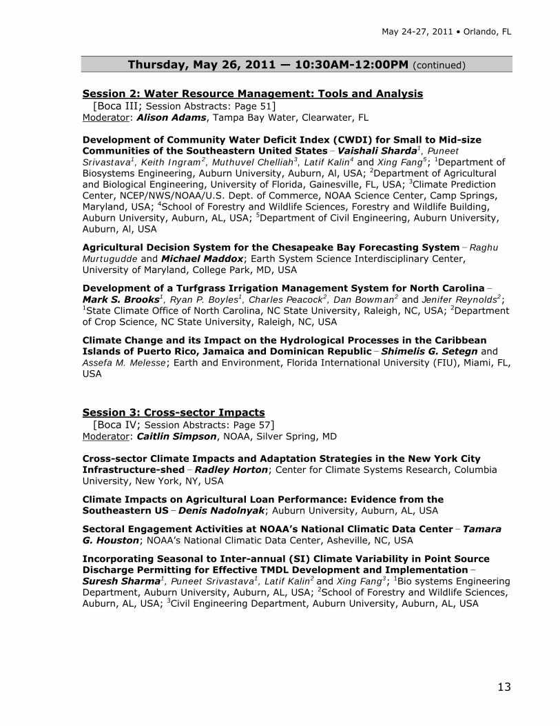
Thursday, May 26, 2011 — 10:30AM-12:00PM (continued) Session 2: Water Resource Management: Tools and Analysis [Boca III; Session Abstracts: Page 51] Moderator: Alison Adams, Tampa Bay Water, Clearwater, FL Development of Community Water Deficit Index (CWDI) for Small to Mid-size Communities of the Southeastern United States − Vaishali Sharda1, Puneet Srivastava1, Keith Ingram2, Muthuvel Chelliah3, Latif Kalin4 and Xing Fang5; 1Department of Biosystems Engineering, Auburn University, Auburn, Al, USA; 2Department of Agricultural and Biological Engineering, University of Florida, Gainesville, FL, USA; 3Climate Prediction Center, NCEP/NWS/NOAA/U.S. Dept. of Commerce, NOAA Science Center, Camp Springs, Maryland, USA; 4School of Forestry and Wildlife Sciences, Forestry and Wildlife Building, Auburn University, Auburn, AL, USA; 5Department of Civil Engineering, Auburn University, Auburn, Al, USA
Agricultural Decision System for the Chesapeake Bay Forecasting System − Raghu Murtugudde and Michael Maddox; Earth System Science Interdisciplinary Center, University of Maryland, College Park, MD, USA
Development of a Turfgrass Irrigation Management System for North Carolina − Mark S. Brooks1, Ryan P. Boyles1, Charles Peacock2, Dan Bowman2 and Jenifer Reynolds2; 1State Climate Office of North Carolina, NC State University, Raleigh, NC, USA; 2Department of Crop Science, NC State University, Raleigh, NC, USA
Climate Change and its Impact on the Hydrological Processes in the Caribbean Islands of Puerto Rico, Jamaica and Dominican Republic − Shimelis G. Setegn and Assefa M. Melesse; Earth and Environment, Florida International University (FIU), Miami, FL, USA
Session 3: Cross-sector Impacts [Boca IV; Session Abstracts: Page 57] Moderator: Caitlin Simpson, NOAA, Silver Spring, MD Cross-sector Climate Impacts and Adaptation Strategies in the New York City Infrastructure-shed − Radley Horton; Center for Climate Systems Research, Columbia University, New York, NY, USA
Climate Impacts on Agricultural Loan Performance: Evidence from the Southeastern US − Denis Nadolnyak; Auburn University, Auburn, AL, USA
Sectoral Engagement Activities at NOAA’s National Climatic Data Center − Tamara G. Houston; NOAA’s National Climatic Data Center, Asheville, NC, USA
Incorporating Seasonal to Inter-annual (SI) Climate Variability in Point Source Discharge Permitting for Effective TMDL Development and Implementation − Suresh Sharma1, Puneet Srivastava1, Latif Kalin2 and Xing Fang3; 1Bio systems Engineering Department, Auburn University, Auburn, AL, USA; 2School of Forestry and Wildlife Sciences, Auburn, AL, USA; 3Civil Engineering Department, Auburn University, Auburn, AL, USA
Climate Information for Managing Risks (CIMR): Local to Regional Adaptation and Mitigation Strategies
14
Thursday, May 26, 2011 — 1:30PM-3:00PM
Session 1: Managing Risks to Agriculture – Indirect Effects [Boca I/II; Session Abstracts: Page 63] Moderator: Gerald Arkin, University of Georgia, Griffin, GA Influence of ENSO Phase on Optimal Corn Planting Dates in North Carolina − Gail G. Wilkerson1, Gregory S. Buol1, Ronnie W. Heiniger1, Heather A. Dinon2 and Ryan P. Boyles2; 1Department of Crop Science, North Carolina State University, Raleigh, NC, USA; 2State Climate Office, North Carolina State University, Raleigh, NC, USA
Effect of Rainfall and Maximum Temperature on Corn Aflatoxin Contamination in the Southeastern U.S. Coastal Plain − Arnold R. Salvacion1, Brenda V. Ortiz1, Brian .T. Scully2, David .M. Wilson3, Gerrit Hoogenboom4 and Dewey Lee3; 1Agronomy and Soils Department, Auburn University, Auburn, AL, USA; 2USDA-ARS, Tifton, GA, USA; 3University of Georgia, Tifton, GA, USA; 4AgWeatherNet, Washington State University, Prosser, WA, USA
Yield Forecasting: An Approach Using Crop Simulation Models − Santiago Meira, Edgardo Guevara, Carlos Hernandorena and Jimena Introna; National Institute for Agricultural Technology (INTA) 2700 Pergamino, Buenos Aires, Argentina
Session 2: Coastal and Urban Communities: Sea Level Rise Impacts [Boca III; Session Abstracts: Page 69] Moderator: Radley Horton, Center for Climate Systems Research, Columbia University, New York, NY Rising Sea Level and the Vulnerable Coastal Communities in the U.S-Affiliated Pacific Islands − Md. Rashed Chowdhury1 and Thomas A. Schroeder2; 1Pacific ENSO Applications Climate Center (PEAC), Joint Institute for Marine and Atmospheric Research (JIMAR), University of Hawaii at Manoa, USA; 2JIMAR, School of Ocean and Earth Science and Technology, University of Hawaii at Manoa, USA
Fighting Water with Water: Counteracting the Impacts of Sea Level Rise on South Florida Waters − Barry N. Heimlich1 and Frederick Bloetscher2; 1Center for Environmental Studies, Climate Change Research Initiative, Florida Atlantic University, Jupiter, FL; 2Department of Civil, Environmental, and Geomatics Engineering, Florida Atlantic University, Boca Raton, FL
Flood Risk and Risk Perception: Evidence from Property Prices in Georgia − Susana Ferreira and Ajita Atreya; The University of Georgia, Athens, GA, USA
GIS Sea Level Rise Vulnerability Assessment − Tara McCue, AICP; East Central Florida Regional Planning Council, Altamonte Springs, FL, USA

May 24-27, 2011 • Orlando, FL
15
Thursday, May 26, 2011 — 3:30PM-5:00PM Session 1: Biodiversity and Conservation in Natural Ecosystems [Boca IV; Session Abstracts: Page 75] Moderator: John Hayes, University of Florida, Gainesville, FL Forest Diversity and its Conservation − Juan Alba-Landa, Lilia del C. Mendizábal-Hernández, Elba O. Ramírez-García, Juan Márquez Ramírez and Héctor Cruz-Jiménez; C.A. Recursos Genéticos Forestales, Universidad Veracruzana, Xalapa, Veracruz, México
Current Efforts and Future Directions: A State Agency's Approach to Climate Change − Doug Parsons; Florida Fish and Wildlife Conservation Commission, Tallahassee, FL, USA
Climate Change and Fisheries in Bangladesh: Impact and Adaptation − M. A. Salam1, M. S. Alam1, M. A. Bashar1 and Jianbang Gan2; 1Department of Aquaculture, Bangladesh Agricultural University, Mymensingh, Bangladesh; 2Department of Ecosystem Science and Management, University of Texas A&M, TX, USA
Large-scale Implications of SLR on Conservation Priority Areas in Florida − Tom Hoctor; Center for Landscape Conservation Planning, College of Design, Construction, and Planning, University of Florida, Gainesville, FL, USA
Session 2: Coastal and Urban Communities: Policy Planning and Adaptation [Boca III; Session Abstracts: Page 81] Moderator: Adam Parris, NOAA's Climate Program Office, Silver Spring, MD Assessing Municipal Vulnerability to Predicted Sea Level Rise: City of Satellite Beach, FL − Randall W. Parkinson, Ph.D., P.G.; RWParkinson Consulting Inc., Melbourne, FL, USA
Sea Level Rise at the Local Government Level: Lessons Learned − John Fergus, Ph.D; City of Satellite Beach, FL, USA
Southwest Florida Plans for Climate Change − James W. Beever III1, Whitney Gray1, Daniel Trescott1, Jason Utley1, David Hutchinson1, Tim Walker1, Dan Cobb1 and Lisa Beever2; 1Southwest Florida Regional Planning Council, Ft. Myers, FL, USA; 2Charlotte Harbor National Estuary Program, Ft. Myers, FL, USA
Climate Change Projections and Adaptation Strategies for Multi-Objective Resource Management at Kennedy Space Center, Florida − Carlton Hall1, Brean Duncan1, John Drese1, Dave Breininger1, Eric Stolen1, Paul Schmalzer1, Doug Scheidt1, Ron Schaub1,Tim Kozusko1, Ray Wheeler2 and John Shaffer2; 1Innovative Health Applications; 2NASA, KSC
Climate Information for Managing Risks (CIMR): Local to Regional Adaptation and Mitigation Strategies
16
Thursday, May 26, 2011 — 3:30PM-5:00PM (continued) Session 3: Land Use and Land Cover Changes [Boca I/II; Session Abstracts: Page 87] Moderator: Jim Jones, Department of Agricultural and Biological Engineering, IFAS, UF Director of the Florida Climate Institute, Gainesville, FL Anthropogenic Influence on Climate over the Southeast United States − V. Misra; Department of Earth, Ocean, and Atmospheric Science, Florida State University, Tallahassee, Florida, USA
Summer 2010 Heat in SE USA - Was It Really a Record? − John R. Christy; University of Alabama in Huntsville, Huntsville, AL, USA
Modeling Sea Level Rise Impacts on Coastal Wetlands at Gulf of Mexico Estuaries − Doria Gordon1, Laura Geselbracht2, Kathleen Freeman3 and Eugene Kelly3; 1University of Florida, Department of Biology, Gainesville, FL, USA; 2The Nature Conservancy, Wilton Manors, FL, USA; 3The Nature Conservancy, Altamonte Springs, FL, USA
Feasibility Study of Biodiesel from Jatropha in Egypt − Guzine El Diwani1, Shadia Ragheb1, Salwa Hawash1, Nahed K.Atteya1 and Ihab H. Farag2; 1Chem. Engineering and Pilot Plant Dept., Eng. Res. Division, National Research Centre, Cairo, Egypt; 2Chemical Engineering Department, University of New Hampshire (UNH), Durham, NH, USA

May 24-27, 2011 • Orlando, FL
17
Poster Directory Poster presentations are listed by topic and in alphabetical order by the presenting author’s last name.
Coastal and Urban Communities Poster Number [Abstracts: Page 93]
1 ....... Risk Quantification for Sustaining Coastal Military Installation Assets and Mission Capabilities − Kelly A. Burks-Copes and Edmond J. Russo; Environmental Laboratory, US Army Engineer Research and Development Center, Vicksburg, MS
2 ....... Factors Facilitating Sea Level Rise Adaptation Planning − Kathryn I. Frank; Department of Urban and Regional Planning, University of Florida, Gainesville, FL, USA
3 ....... Regional Policies and Strategies for Climate Change Adaptation − Tara McCue and Keith Smith; East Central Florida Regional Planning Council, Altamonte Springs, FL, USA
4 ....... Using Climate Risk Information in Assessing the Vulnerability of Coastal Areas in the Southeast: The Case of Louisiana and Mississippi − Edmund Merem, Yaw Twumasi, Joan Wesley, Sudha Yeramilli, Chandra Richardson and B. Robinson; Department of Urban and Regional Planning, Jackson State University, Jackson, MS, USA
5 ....... Using Surface Population Models to Improve Spatial Accuracy of Sea Level Rise Vulnerability Assessment − Diana Mitsova, Ann-Margaret Esnard and Yanmei Li; Florida Atlantic University, Boca Raton, Florida, USA
Land Use and Land Cover Changes Poster Number [Abstracts: Page 101]
6 ....... Vegetation Change Detection Using Remote Sensing in the Florida Everglades − Shimelis G Setegn1,2 and Rosanna Rivero2; 1Florida International University, Department of Earth and Environmental, Miami, Florida, USA; 2Everglades Foundation, Palmetto Bay, Florida, USA
7 ....... Impact of Biofuels on the Propensity of Land-Use Conversion among Non-Industrial Private Forest Landowners in Florida − Nishita Pancholy1, Michael H. Thomas1, Daniel Solís2 and Nicholas Stratis3; 1Florida A&M University, Division of Agricultural Sciences, Tallahassee, FL; 2University of Miami, Division of Marine Affairs and Policy, RSMAS, Miami, FL; 3Department of Environmental Protection, and Florida State University, Tallahassee, FL

Climate Information for Managing Risks (CIMR): Local to Regional Adaptation and Mitigation Strategies
18
Managing Risks to Agriculture Poster Number [Abstracts: Page 105]
9 ....... Agricultural Applications for a Linear Inverse Model Describing Midsummer Dry Spell Variability within the Intra-Americas Sea − Teddy Allen; Rosenstiel School of Marine & Atmospheric Science, The University of Miami, Miami, FL, USA
10 ..... Climatic Elements Variability Affecting Maize Yield in Northern Minas Gerais, Brazil − Maria Emilia B. Alves1, Camilo L. T. Andrade1, Ramiro Ruiz-Cárdenas2, Tales A. Amaral1 and Denise F. Silva1; 1Embrapa Maize and Sorghum, Sete Lagoas, MG, Brazil; 2Department of Statistics, Federal University of Minas Gerais, Belo Horizonte, MG, Brazil
11 ..... Seasonal Rainfall Forecasts as an Adaptation Strategy for Climate Change − Senthold Asseng1,2, Peter McIntosh3, Guomin Wang4 and Nirav Khimashia5; 1Universtity of Florida, Department of Agricultural and Biological Engineering, Gainesville, FL, USA; 2Former address: Centre for Environment and Life Sciences, CSIRO Climate Adaptation Flagship, Wembley, Australia; 3Centre for Australian Weather and Climate Research, CSIRO Climate Adaptation Flagship, Hobart, Australia; 4Centre for Australian Weather and Climate Research, Bureau of Meteorology, Melbourne, Australia; 5Centre for Environment and Life Sciences, CSIRO Climate Adaptation Flagship, Wembley, Australia
12 ..... The Impact of Climate Change on Soybean Production in the Southeastern USA and Potential Adaptation Strategies − Yawen Bao1, Gerrit Hoogenboom2 and Ron McClendon1; 1Department of Biological and Agricultural Engineering, The University of Georgia, Athens, GA, USA; 2AgWeatherNet, Washington State University, Prosser, WA, USA
13 ..... Climate Decision Support Research to Foster Resilience in Agrosocioecosystems − Norman E. Breuer1 and Clyde W. Fraisse2; 1Rosenstiel School of Marine and Atmospheric Science, University of Miami; 2Dept. of Agricultural and Biological Engineering, University of Florida
14 ..... Climate Change and Agriculture: Perspectives from Michigan Farmers − Julie E. Doll1 and Claire N. Layman2; 1W.K. Kellogg Biological Station, Michigan State University, Hickory Corners, MI USA; 2Michigan State University Extension, East Lansing, MI USA
15 ..... FAWN: Providing Weather-related Information to a Wide Variety of Users since 1998 − Brent Ferraro; Institute of Food and Agricultural Sciences, University of Florida, Gainesville, FL USA
16 ..... AgroClimate: Climate Information and Decision Support Tools for Reducing Risk in Agriculture − C. Fraisse, O. Uryasev, B. Ferraro, C. Villalobos, Z. Hu and T. Zortea; Agricultural and Biological Engineering, University of Florida, Gainesville, FL, USA
18 ..... Spatial and Temporal Variability of the Agricultural Reference Index of Drought (ARID) in Florida − Eduardo Gelcer1, Clyde Fraisse1, Jerome Maleski1, Zhengjun Hu1 and Renan Mendes2; 1Department of Agricultural and Biological Engineering, University of Florida, Gainesville, FL, USA; 2Mines Paristech Engineering School, Paris, France

May 24-27, 2011 • Orlando, FL
19
Managing Risks to Agriculture (continued) Poster Number
19 ..... Climate Scenario Generation for the Agricultural Model Intercomparison and Improvement Project (AgMIP) − Cynthia Rosenzweig1, Jim Jones2, Jerry Hatfield3, Alex Ruane1 and Radley Horton4; 1NASA Goddard Institute for Space Studies; New York, NY, USA; 2University of Florida; Gainesville, FL, USA; 3USDA-Agricultural Research Service; Ames, IA, USA; 4Center for Climate Systems Research, Columbia University, New York, NY, USA
20 ..... Monitoring and Managing Effects of Climate Change on Rangeland Ecosystem Goods and Services − Kristie Maczko1, Daniel W. McCollum2, Jack A. Morgan3, Clifford Duke4, William E. Fox5, Lori A. Hidinger6, Urs Kreuter7, John E. Mitchell8 and John A. Tanaka9; 1Sustainable Rangelands Roundtable, University of Wyoming, Fort Collins, CO; 2Rocky Mountain Research Station, USDA Forest Service, Fort Collins, CO; 3Rangeland Resources Research Unit, USDA-ARS, Fort Collins, CO; 4Science Programs, Ecological Society of America, Washington, DC; 5 Texas AgriLife Research, Texas A&M University, Temple, TX; 6Consortium for Science, Policy and Outcomes, Arizona State University, Tempe, AZ; 7Ecosystem Science and Management, Texas A&M University - College Station, College Station, TX; 8USDA Forest Service, Rocky Mountain Research Station, Fort Collins, CO; 9Department of Renewable Resources, University of Wyoming, Laramie, WY
21 ..... Monitoring and Modeling Leaf Wetness Duration for Optimizing Fungicide Use in Strawberry Production − Verona Oliveira Montone1, Natalia Peres2 and Clyde Fraisse1; 1Department of Agricultural and Biological Engineering, University of Florida, Gainesville, FL, USA; 2Gulf Coast Research and Education Center, University of Florida, Wimauma, FL, USA
22 ..... Financial Management of Beginning Farmers and the Use of Climate Information − Denis Nadolnyak; Auburn University, Auburn, AL, USA
23 ..... Long-Term Climate Variability and Rainfall Index Insurance − Denis Nadolnyak; Auburn University, Auburn, AL, USA
24 ..... ENSO and Corn Aflatoxin Contamination in the Southeastern U.S. − Arnold R. Salvacion1, Brenda V. Ortiz1, Gerrit Hoogenboom4, Brian .T. Scully2, David .M. Wilson3 and Dewey Lee3; 1Agronomy and Soils Department, Auburn University, Auburn, AL, USA; 2USDA-ARS, Tifton, GA, USA; 3University of Georgia, Tifton, GA, USA; 4AgWeatherNet, Washington State University, Prosser, WA, USA
25 ..... Soil Temperature: Indicator of Earlier Shifts in Planting Season for Agronomic and Horticulture Crops − Tapan B. Pathak1, Kenneth G. Hubbard1,2 and Martha Shulski1,2; 1School of Natural Resources, University of Nebraska, Lincoln, NE, USA; 2High Plains Regional Climate Center, University of Nebraska, Lincoln, NE, USA
17 ..... Risk Mapping to Support Decision Making on Plant Disease Management in Brazil − Presented by: Clyde Frasisse; Willingthon Pavan1, José Mauricio Cunha Fernandes2, Jorge Luis Boeira Bavaresco1, Jaqson Dalbosco1 and Emerson M. Del Ponte3; 1Curso de Ciência da Computação, Universidade de Passo Fundo, Passo Fundo, RS, Brazil; 2Empresa Brasileira de Pesquisa Agropecuária - Embrapa, Passo Fundo, RS, Brazil; 3Departmento de Fitossanidade, Universidade Federal do Rio Grande do Sul, Porto Alegre, RS, Brazil

Climate Information for Managing Risks (CIMR): Local to Regional Adaptation and Mitigation Strategies
20
Managing Risks to Agriculture (continued) Poster Number
26 ..... Some Edaf- Climatic Effect on Variability of S and B in an Argentine Republic Soil − Emilia Rivero, Gustavo Cruzate, Susana Russo, Marcelo Beltran, Roberto Casas and Tomas Bosco; Soil Institute, CRN- National Institute of Agricultural Technology. Castelar, Buenos Aires- Argentina
27 ..... Edafo- climate Factors in the Variability of Nutrients in an Argentine Republic Soil − Emilia Rivero, Gustavo Cruzate, Susana Russo, Marcelo Beltran, Roberto Michelena and Tomas Bosco; Soil Institute, CRN- National Institute of Agricultural Technology. Castelar,Buenos Aires- Argentina
8 ....... Assessing the Value of Climate Information in Agriculture Using the Stochastic Production Frontier Approach − Daniel Solís and David Letson; University of Miami, Division of Marine Affairs and Policy, RSMAS, Miami, FL
28 ..... Carbon Footprint Calculator − Oxana Uryasev; University of Florida, Gainesville, FL, USA
29 ..... An Approach for Encapsulating Fortran Coded Models into a R Package − Tiago Zortea1, Willingthon Pavan2, José Mauricio Cunha Fernandes3 and Carlos H. Holbig2; 1Department of Agricultural and Biological Engineering, University of Florida, Gainesville, FL, USA; 2Department of Computer Science, University of Passo Fundo, Passo Fundo, RS, Brazil; 3Empresa Brasileira de Pesquisa Agropecuária - Embrapa, Passo Fundo, RS, Brazil
Water Resource Management Poster Number [Abstracts: Page 129]
30 ..... Drought Forecasts for Managing Water Resources in the Face of Climate Variability − Jonathan Alldridge and Christopher Martinez; Department of Agricultural and Biological Engineering, University of Florida, Gainesville, FL, USA
31 ..... Effects of Sea Level Rise and Other Climate Change Impacts on Southeast Florida’s Water Resources − Barry N. Heimlich1 and Frederick Bloetscher2; 1Center for Environmental Studies, Climate Change Research Initiative, Florida Atlantic University, Jupiter, FL; 2Department of Civil, Environmental, and Geomatics Engineering, Florida Atlantic University, Boca Raton, FL
32 ..... Assessing Perceptions, Uses, and Needs for Climate Information among Water Managers in the ACF River Basin − Christopher Martinez1, Norman Breuer2, P. Srivastava3 and Jessica Bolson1; 1Department of Agricultural and Biological Engineering, University of Florida, Gainesville, FL, USA; 2Rosenstiel School of Marine and Atmospheric Science, University of Miami, Miami, FL, USA; 3Department of Agricultural Engineering, Auburn University, Auburn, GA, USA
33 ..... ENSO Impacts on Heavy Rain Events in the Southeast − James J. O’Brien, Preston W. Leftwich and David F. Zierden; Center for Ocean-Atmospheric Prediction Studies, Florida State University, Tallahassee, FL, USA
34 ..... Optimized Climatic Indicators to Provide Probability of Exceedance Streamflow Forecasts − Susan Risko and Chris Martinez; Department of Agricultural and Biological Engineering, University of Florida, Gainesville, FL USA
35 ..... Assessment of Precipitation Reforecast Analogs in the Tampa Bay Region − Christopher J. Martinez and Robert W. Rooney; Department of Agricultural and Biological Engineering, University of Florida, Gainesville, FL, USA
May 24-27, 2011 • Orlando, FL
21
Plenary Speaker Biographies Wednesday, May 25, 2011
Keynote Address: Climate Science and Service from Local to Global Scales
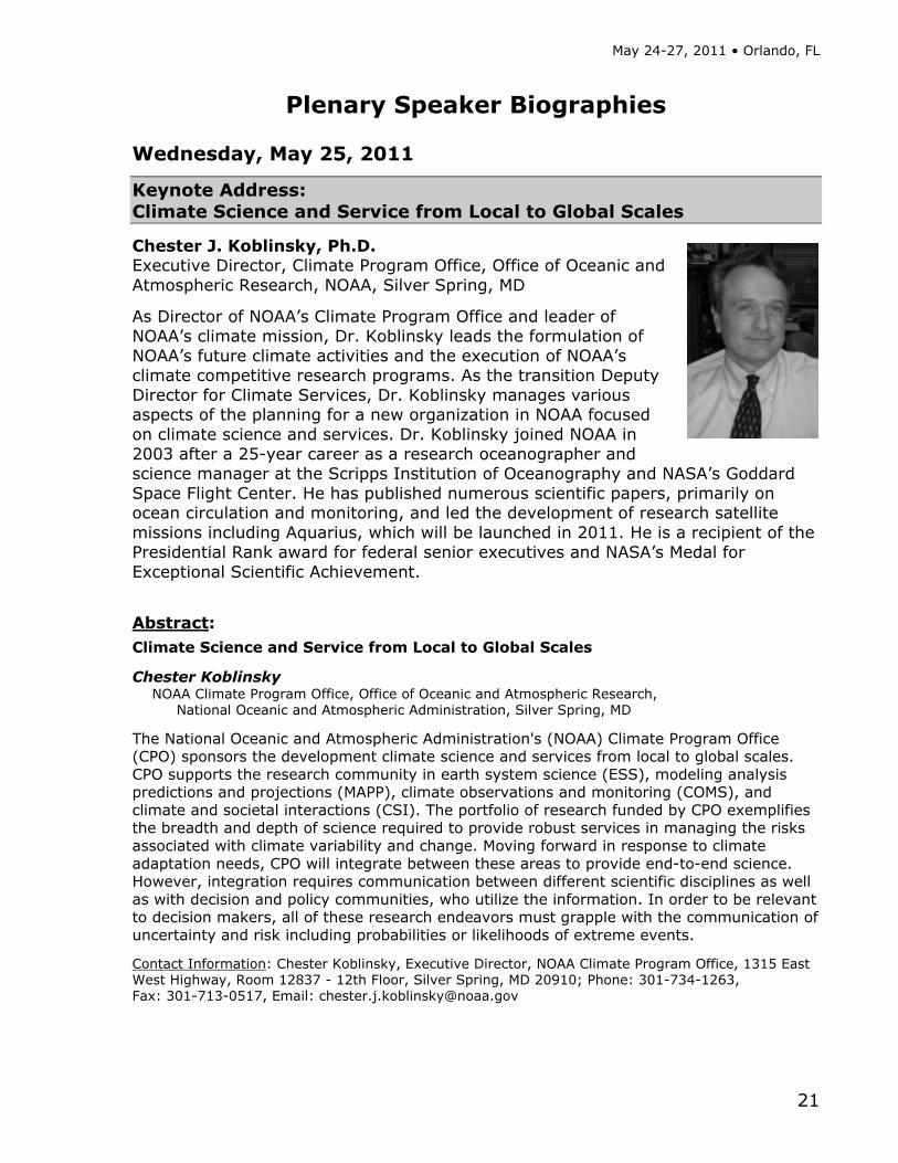
Chester J. Koblinsky, Ph.D. Executive Director, Climate Program Office, Office of Oceanic and Atmospheric Research, NOAA, Silver Spring, MD
As Director of NOAA’s Climate Program Office and leader of NOAA’s climate mission, Dr. Koblinsky leads the formulation of NOAA’s future climate activities and the execution of NOAA’s climate competitive research programs. As the transition Deputy Director for Climate Services, Dr. Koblinsky manages various aspects of the planning for a new organization in NOAA focused on climate science and services. Dr. Koblinsky joined NOAA in 2003 after a 25-year career as a research oceanographer and science manager at the Scripps Institution of Oceanography and NASA’s Goddard Space Flight Center. He has published numerous scientific papers, primarily on ocean circulation and monitoring, and led the development of research satellite missions including Aquarius, which will be launched in 2011. He is a recipient of the Presidential Rank award for federal senior executives and NASA’s Medal for Exceptional Scientific Achievement.
Abstract: Climate Science and Service from Local to Global Scales
Chester Koblinsky NOAA Climate Program Office, Office of Oceanic and Atmospheric Research,
National Oceanic and Atmospheric Administration, Silver Spring, MD
The National Oceanic and Atmospheric Administration's (NOAA) Climate Program Office (CPO) sponsors the development climate science and services from local to global scales. CPO supports the research community in earth system science (ESS), modeling analysis predictions and projections (MAPP), climate observations and monitoring (COMS), and climate and societal interactions (CSI). The portfolio of research funded by CPO exemplifies the breadth and depth of science required to provide robust services in managing the risks associated with climate variability and change. Moving forward in response to climate adaptation needs, CPO will integrate between these areas to provide end-to-end science. However, integration requires communication between different scientific disciplines as well as with decision and policy communities, who utilize the information. In order to be relevant to decision makers, all of these research endeavors must grapple with the communication of uncertainty and risk including probabilities or likelihoods of extreme events.
Contact Information: Chester Koblinsky, Executive Director, NOAA Climate Program Office, 1315 East West Highway, Room 12837 - 12th Floor, Silver Spring, MD 20910; Phone: 301-734-1263, Fax: 301-713-0517, Email: [email protected]
Climate Information for Managing Risks (CIMR): Local to Regional Adaptation and Mitigation Strategies
22
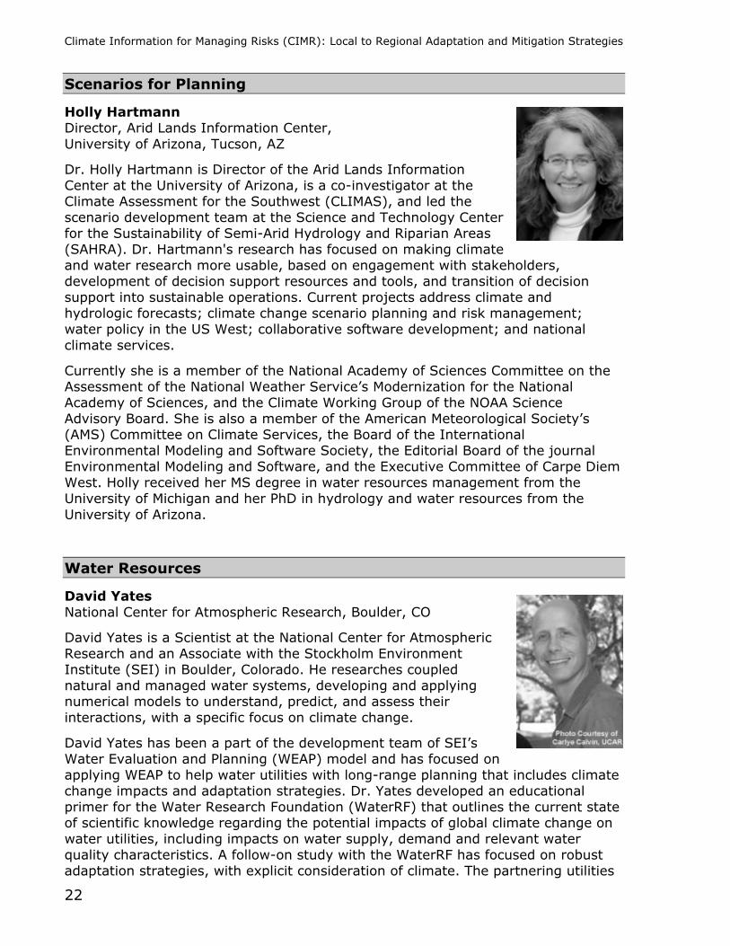
Scenarios for Planning
Holly Hartmann Director, Arid Lands Information Center, University of Arizona, Tucson, AZ
Dr. Holly Hartmann is Director of the Arid Lands Information Center at the University of Arizona, is a co-investigator at the Climate Assessment for the Southwest (CLIMAS), and led the scenario development team at the Science and Technology Center for the Sustainability of Semi-Arid Hydrology and Riparian Areas (SAHRA). Dr. Hartmann's research has focused on making climate and water research more usable, based on engagement with stakeholders, development of decision support resources and tools, and transition of decision support into sustainable operations. Current projects address climate and hydrologic forecasts; climate change scenario planning and risk management; water policy in the US West; collaborative software development; and national climate services.
Currently she is a member of the National Academy of Sciences Committee on the Assessment of the National Weather Service’s Modernization for the National Academy of Sciences, and the Climate Working Group of the NOAA Science Advisory Board. She is also a member of the American Meteorological Society’s (AMS) Committee on Climate Services, the Board of the International Environmental Modeling and Software Society, the Editorial Board of the journal Environmental Modeling and Software, and the Executive Committee of Carpe Diem West. Holly received her MS degree in water resources management from the University of Michigan and her PhD in hydrology and water resources from the University of Arizona.
Water Resources
David Yates National Center for Atmospheric Research, Boulder, CO
David Yates is a Scientist at the National Center for Atmospheric Research and an Associate with the Stockholm Environment Institute (SEI) in Boulder, Colorado. He researches coupled natural and managed water systems, developing and applying numerical models to understand, predict, and assess their interactions, with a specific focus on climate change.
David Yates has been a part of the development team of SEI’s Water Evaluation and Planning (WEAP) model and has focused on applying WEAP to help water utilities with long-range planning that includes climate change impacts and adaptation strategies. Dr. Yates developed an educational primer for the Water Research Foundation (WaterRF) that outlines the current state of scientific knowledge regarding the potential impacts of global climate change on water utilities, including impacts on water supply, demand and relevant water quality characteristics. A follow-on study with the WaterRF has focused on robust adaptation strategies, with explicit consideration of climate. The partnering utilities

May 24-27, 2011 • Orlando, FL
23
include the Inland Empire Utility Agency (CA), the El Dorado Irrigation District (CA), Portland Water (OR), Colorado Springs Utilities (CO), Massachusetts Water Resource Authority (MA), Durham Water (NC), and Palm Beach County Water (FL).
Coastal and Urban Communities
Margaret Davidson Director, NOAA Coastal Services Center, Charleston, SC
Margaret Davidson has been an active participant in coastal resource management issues since 1978, when she earned her juris doctorate in natural resources law from Louisiana State University. She later earned a master’s degree in marine policy and resource economics from the University of Rhode Island.
Davidson served as special counsel and assistant attorney general for the Louisiana Department of Justice, and was the executive director of the South Carolina Sea Grant Consortium. She joined NOAA as the director of the NOAA Coastal Services Center in 1995, a position she continues to hold. During this time she also served as the acting assistant administrator for NOAA’s National Ocean Service from 2000 to 2002. She holds a faculty appointment at the University of Charleston and serves on the adjunct faculties of Clemson University and the University of South Carolina.
Davidson has served on numerous local, state, and federal committees and has provided leadership for national professional societies. She has focused her professional work on environmentally sustainable aquaculture, mitigation of coastal hazards, and impacts of climate variability on coastal resources.
Biodiversity and Conservation
Jean Brennan Coordinator, Appalachian LLC, US Fish and Wildlife Service, Blacksburg, VA
Jean Brennan is a Landscape Conservation Coordinator for the U.S. Fish and Wildlife Service, working with the Appalachian Landscape Conservation Cooperative (LCC). The geographic extent of the Appalachian LCC extends from southern New York State to central Alabama and from southern Illinois to central Virginia. It is part of a national conservation network established through the Department of Interior.
As the Appalachian LCC Coordinator, Jean works with land and resource management agencies, environmental organizations, and regional initiatives, to forge strategic collaborative science-management partnership among individuals and organizations to achieved shared goals. Such partnerships are intended to promote innovative, practical, landscape-level strategies for managing large-scale and climate change impacts and other broad-scale changes.

Climate Information for Managing Risks (CIMR): Local to Regional Adaptation and Mitigation Strategies
24
Before joining the U.S. Fish and Wildlife Service, Dr. Brennan worked as a Senior Climate Change Scientist for an environmental NGO based in Washington DC. Her work involved synthetic research into the impacts of climate change on natural systems and adaptation strategies. She has also worked extensively internationally as Senior Conservation Scientist for the U.S. Agency for International Development, and as a staff scientist for the U.S. State Department, Office of Global Change. Jean served as a member of the U.S. Delegation to the Intergovernmental Panel on Climate Change (IPCC) and was honored to be selected among a small group of scientists recognized by the IPCC for her contributions and shares the 2007 Nobel Peace Prize awarded to the IPCC.
She is an accomplished field biologist and holds graduate degrees in Population Biology and Genetics from the University of Tennessee; Forest Ecology from Yale University School of Forestry; and Anthropology from the University of Pennsylvania. She has taught Conservation Biology at the University of Michigan, School of Natural Resources and Environment, and Air Resources at the University of California Davis.
Agricultural Risk Management
Cynthia Rosenzweig NASA Goddard Institute for Space Studies, New York, NY
Dr. Cynthia Rosenzweig is a Senior Research Scientist at NASA Goddard Institute for Space Studies where she heads the Climate Impacts Group. She has organized and led large-scale interdisciplinary regional, national, and international studies of climate change impacts and adaptation. She is a co-chair of the New York City Panel on Climate Change, a body of experts convened by the mayor to advise the city on adaptation for its critical infrastructure. She has co-led the Metropolitan East Coast Regional Assessment of the U.S. National Assessment of the Potential Consequences of Climate Variability and Change, sponsored by the U.S. Global Change Research Program. She was a Coordinating Lead Author of the IPCC Working Group II Fourth Assessment Report observed changes chapter, and served on the IPCC Task Group on Data and Scenarios for Impact and Climate Assessment. Dr. Rosenzweig's research involves the development of interdisciplinary methodologies to assess the potential impacts of and adaptations to global environmental change. A recipient of a Guggenheim Fellowship, she joins impact models with climate models to predict future outcomes of both land-based and urban systems under altered climate conditions. She is a Professor at Barnard College and a Senior Research Scientist at the Columbia Earth Institute.
May 24-27, 2011 • Orlando, FL
25
Cross-sectoral Impacts
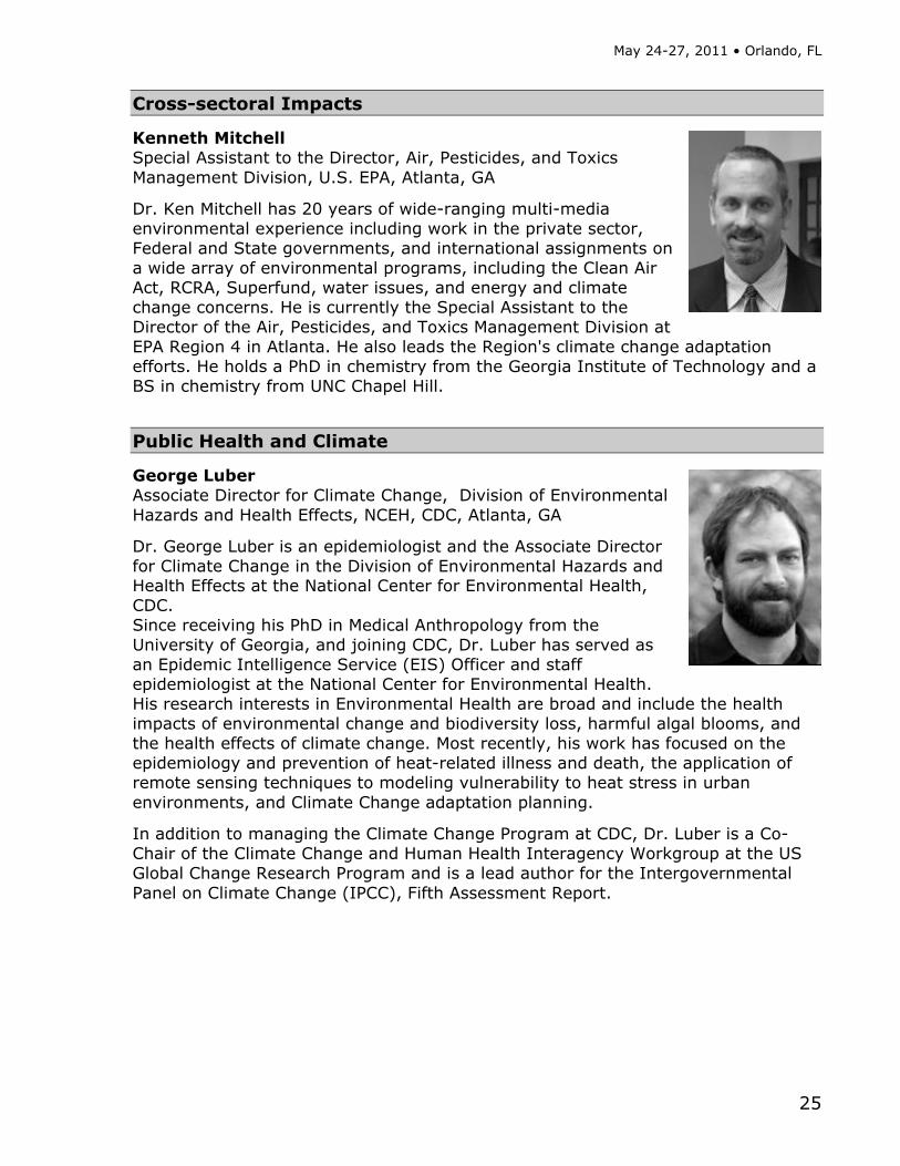
Kenneth Mitchell Special Assistant to the Director, Air, Pesticides, and Toxics Management Division, U.S. EPA, Atlanta, GA
Dr. Ken Mitchell has 20 years of wide-ranging multi-media environmental experience including work in the private sector, Federal and State governments, and international assignments on a wide array of environmental programs, including the Clean Air Act, RCRA, Superfund, water issues, and energy and climate change concerns. He is currently the Special Assistant to the Director of the Air, Pesticides, and Toxics Management Division at EPA Region 4 in Atlanta. He also leads the Region's climate change adaptation efforts. He holds a PhD in chemistry from the Georgia Institute of Technology and a BS in chemistry from UNC Chapel Hill.
Public Health and Climate
George Luber Associate Director for Climate Change, Division of Environmental Hazards and Health Effects, NCEH, CDC, Atlanta, GA
Dr. George Luber is an epidemiologist and the Associate Director for Climate Change in the Division of Environmental Hazards and Health Effects at the National Center for Environmental Health, CDC. Since receiving his PhD in Medical Anthropology from the University of Georgia, and joining CDC, Dr. Luber has served as an Epidemic Intelligence Service (EIS) Officer and staff epidemiologist at the National Center for Environmental Health. His research interests in Environmental Health are broad and include the health impacts of environmental change and biodiversity loss, harmful algal blooms, and the health effects of climate change. Most recently, his work has focused on the epidemiology and prevention of heat-related illness and death, the application of remote sensing techniques to modeling vulnerability to heat stress in urban environments, and Climate Change adaptation planning.
In addition to managing the Climate Change Program at CDC, Dr. Luber is a Co-Chair of the Climate Change and Human Health Interagency Workgroup at the US Global Change Research Program and is a lead author for the Intergovernmental Panel on Climate Change (IPCC), Fifth Assessment Report.
Climate Information for Managing Risks (CIMR): Local to Regional Adaptation and Mitigation Strategies
26
Miami-Dade: A Case Study on Adaptation and Mitigation
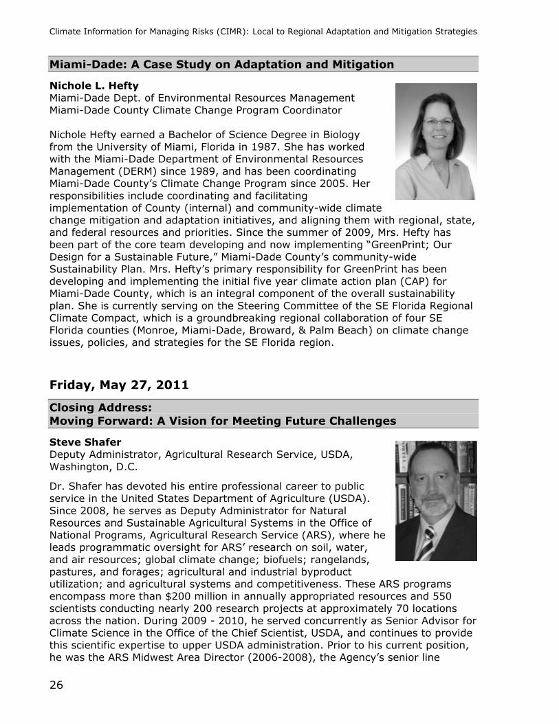
Nichole L. Hefty Miami-Dade Dept. of Environmental Resources Management Miami-Dade County Climate Change Program Coordinator Nichole Hefty earned a Bachelor of Science Degree in Biology from the University of Miami, Florida in 1987. She has worked with the Miami-Dade Department of Environmental Resources Management (DERM) since 1989, and has been coordinating Miami-Dade County’s Climate Change Program since 2005. Her responsibilities include coordinating and facilitating implementation of County (internal) and community-wide climate change mitigation and adaptation initiatives, and aligning them with regional, state, and federal resources and priorities. Since the summer of 2009, Mrs. Hefty has been part of the core team developing and now implementing “GreenPrint; Our Design for a Sustainable Future,” Miami-Dade County’s community-wide Sustainability Plan. Mrs. Hefty’s primary responsibility for GreenPrint has been developing and implementing the initial five year climate action plan (CAP) for Miami-Dade County, which is an integral component of the overall sustainability plan. She is currently serving on the Steering Committee of the SE Florida Regional Climate Compact, which is a groundbreaking regional collaboration of four SE Florida counties (Monroe, Miami-Dade, Broward, & Palm Beach) on climate change issues, policies, and strategies for the SE Florida region.
Friday, May 27, 2011
Closing Address: Moving Forward: A Vision for Meeting Future Challenges
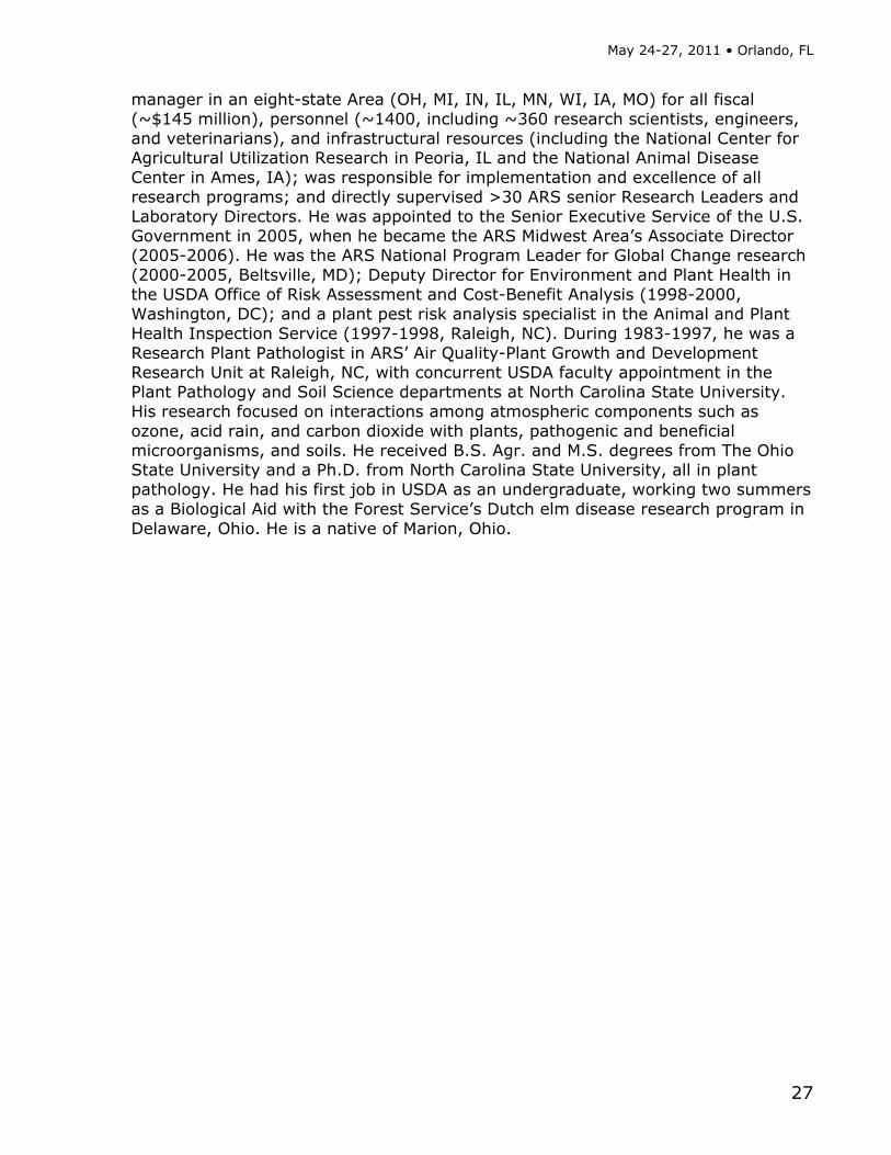
Steve Shafer Deputy Administrator, Agricultural Research Service, USDA, Washington, D.C.
Dr. Shafer has devoted his entire professional career to public service in the United States Department of Agriculture (USDA). Since 2008, he serves as Deputy Administrator for Natural Resources and Sustainable Agricultural Systems in the Office of National Programs, Agricultural Research Service (ARS), where he leads programmatic oversight for ARS’ research on soil, water, and air resources; global climate change; biofuels; rangelands, pastures, and forages; agricultural and industrial byproduct utilization; and agricultural systems and competitiveness. These ARS programs encompass more than $200 million in annually appropriated resources and 550 scientists conducting nearly 200 research projects at approximately 70 locations across the nation. During 2009 - 2010, he served concurrently as Senior Advisor for Climate Science in the Office of the Chief Scientist, USDA, and continues to provide this scientific expertise to upper USDA administration. Prior to his current position, he was the ARS Midwest Area Director (2006-2008), the Agency’s senior line
May 24-27, 2011 • Orlando, FL
27
manager in an eight-state Area (OH, MI, IN, IL, MN, WI, IA, MO) for all fiscal (~$145 million), personnel (~1400, including ~360 research scientists, engineers, and veterinarians), and infrastructural resources (including the National Center for Agricultural Utilization Research in Peoria, IL and the National Animal Disease Center in Ames, IA); was responsible for implementation and excellence of all research programs; and directly supervised >30 ARS senior Research Leaders and Laboratory Directors. He was appointed to the Senior Executive Service of the U.S. Government in 2005, when he became the ARS Midwest Area’s Associate Director (2005-2006). He was the ARS National Program Leader for Global Change research (2000-2005, Beltsville, MD); Deputy Director for Environment and Plant Health in the USDA Office of Risk Assessment and Cost-Benefit Analysis (1998-2000, Washington, DC); and a plant pest risk analysis specialist in the Animal and Plant Health Inspection Service (1997-1998, Raleigh, NC). During 1983-1997, he was a Research Plant Pathologist in ARS’ Air Quality-Plant Growth and Development Research Unit at Raleigh, NC, with concurrent USDA faculty appointment in the Plant Pathology and Soil Science departments at North Carolina State University. His research focused on interactions among atmospheric components such as ozone, acid rain, and carbon dioxide with plants, pathogenic and beneficial microorganisms, and soils. He received B.S. Agr. and M.S. degrees from The Ohio State University and a Ph.D. from North Carolina State University, all in plant pathology. He had his first job in USDA as an undergraduate, working two summers as a Biological Aid with the Forest Service’s Dutch elm disease research program in Delaware, Ohio. He is a native of Marion, Ohio.

Climate Information for Managing Risks (CIMR): Local to Regional Adaptation and Mitigation Strategies
28
May 24-27, 2011 • Orlando, FL
29
Thursday, May 26, 2011 8:30AM-10:00AM
Concurrent Panel Session 1 Managing Risks to Agriculture—A World Perspective

Climate Information for Managing Risks (CIMR): Local to Regional Adaptation and Mitigation Strategies
30
May 24-27, 2011 • Orlando, FL
31
Farmers’ Perceptions of Risk, Impacts and Adaptations to Climate Change: A Perspective from Western India
Dineshkumar Moghariya and Richard C. Samrdon Department of Environmental Studies, State University of New York College of Environmental
Science and Forestry, Syracuse, NY, USA People’s risk perceptions and their levels of concern can compel or constraint climate change policy. A study initiated in rural Saurastra and Kutch region of Western India informs that rural people are able to detect climate change correctly; however there exist misconception about climate change knowledge. Farmers detect a wide range of climate change impacts on their agriculture and farm properties, ranging from increased pest and disease infestation, decrease in quality and quantity of agriculture production, and disturbance in cattle conception to damage to their farm properties such as water pipelines. Farmers perceive moderate to high risks, detect wide range of impacts on their agriculture; however they are moderately concerned about risks of climate change. They think that innovations and non farm income options would protect them from adverse impacts of climate change. People in cyclone prone area express higher levels of perceived risk and slightly higher levels of concerns than their counterparts in drought prone areas. Farmers use integrated approach with blend of traditional and modern practices such as crop rotation, intercropping, water harvesting to use of chemical fertilizers and pesticides and hybrid BT seeds for successful adaptation to climate change. There is need to make people aware of causes, impacts and solutions to climate change as a science and economics, to include everybody in addressing the issue of climate change. Contact Information: Dineshkumar Moghariya, Department of Environmental Science, State University of New York College of Environmental Science and Forestry, 1’ Forestry Drive, Syracuse, NY 13210, USA; Phone: 315-586-2094, Email: [email protected]
Climate Information for Managing Risks (CIMR): Local to Regional Adaptation and Mitigation Strategies
32
Climate Services for Vulnerable Communities: Listening to African American Farmers
Carrie Furman1, Carla Roncoli2, Wendy-Lin Bartels3, Mark Boudreau1, Heather Gray4 and Gerrit Hoogenboom5
1Department of Biological and Agricultural Engineering, University of Georgia, Athens, GA USA 2Master's in Development Practice, Emory University, Atlanta, GA USA 3Department of Agricultural Education and Communication, University of Florida, Gainesville FL USA 4Federation of Southern Cooperatives, Atlanta, GA USA 5AgWeatherNet, Washington State University, Prosser, WA USA
The research presented is part of a larger project funded by the NOAA SARP program that aims to develop and disseminate climate information to African American farmers in the Southeastern US. The research was conducted in the context of the Southeast Climate Consortium, whose aim it is to develop and disseminate climate information for risk management in agriculture. We employed a mixed method research design that combined a phone survey, in-depth interviews, farmer workshops, and participant observation. Based on this research, we found that African American farmers are highly vulnerable to climate shocks due to the environmental and social conditions in which they are embedded. African American farmers are less likely to have irrigation, crop insurance, financial resources, and access to technical assistance than conventional farmers. This is due, in part, to the social profile of the population and the small-scale, part-time, diversified nature of their operations. As a result, farmers who face, for example, a multi-year drought risk losing their farms. While many social inequalities need to be remedied to help protect African American farmers, it is imperative that they have access to at least the same climate information and forecasts offered to other farmers in the region. The paper also reports on programmatic lessons learned in the course of an unprecedented partnership among a well-established civil rights organization, and two universities, including an 1862 land-grant university and a 1890s Historically Black University that provides extension services to minority farmers. Contact Information: Carrie A. Furman, Department of Biological and Agricultural Engineering, University of Georgia, 1109 Experiment Street, Griffin, GA 30223-1797, Phone: 770-228-7216, Fax: 706-770-228-7218, Email: [email protected]

May 24-27, 2011 • Orlando, FL
33
Migration of Agriculture to the Southeast as an Adaptation to Regional Climate Change
Richard T. McNider, John R. Christy and Cameron Handyside Earth System Science Center, University of Alabama in Huntsville, Huntsville, AL, USA
At the beginning of the last century most of the United States agricultural production was carried out under a rain-fed agricultural system east of the Mississippi. However, by the end of the last century a significant part of the Nation’s agriculture had migrated to the arid West under irrigation. At the same time during the last century grain production became concentrated in a few states in the deep water holding soils of the upper Midwest. The Southeast with sporadic growing season precipitation and poor water holding soils could not compete economically with the highly efficient production in the West and Midwest and lost substantial agricultural production. The remarkable U.S. agricultural production from irrigation in arid climates developed in the 20th century is likely to contract substantially in the present century due to water resource limitations. The concentration of grain production in the Midwest leaves U.S. food and bio-fuel production vulnerable severe mid-west regional drought. The Southeast may be in a unique position relative to climate change compared to other parts of the country. While regional precipitation changes are uncertain, the IPCC concluded that dry areas are likely to become drier and wet areas wetter. Migration of production back to the Southeast, if sustainable, would be an adaptation strategy to climate change and provide additional capacity for long-term agricultural security. This talk will present preliminary water resource, agricultural and ecological assessments on the viability of this strategy as well as a major new NSF-USDA project. Contact Information: Richard McNider, Earth System Science Center, University of Alabama in Huntsville, Huntsville, AL 35899; Phone 256 961 7756, Fax 256 961 7755, Email: [email protected]
Climate Information for Managing Risks (CIMR): Local to Regional Adaptation and Mitigation Strategies
34
Potential Usefulness of Climate Forecasts and AgroClimate for Agriculture in South Carolina
M. Shane Perkins1, S. Templeton1, H. Dinon2, B. Lassiter3 and J. Whitehead4
1Department of Applied Economics and Statistics, Clemson University, Clemson, SC, USA
2State Climate Office of North Carolina, North Carolina State University, Raleigh, NC, USA 3 Crop Science Department, North Carolina State University, Raleigh, NC, USA 4South Carolina Sea Grant Consortium, Charleston, SC, USA
Seasonal climate variability is a major cause of production risks in agriculture. Farmers can and do use information about this variability to manage the risks. In cooperation with farmers and extension agents, the Southeast Climate Consortium (SECC) has developed AgroClimate to provide such information and related decision-support tools online. The purpose of our research has been to evaluate the potential usefulness of seasonal climate forecasts and AgroClimate for managing agricultural production risks in South Carolina. AgroClimate has seven tools available for the Palmetto State. Twenty two extension agents, specialists, and farmers attended an SECC-sponsored workshop in Florence, South Carolina on January 14 to learn and provide feedback about AgroClimate. Participants in focus groups indicated that County Yield Database, Climate Risk, and Agricultural Reference Index for Drought were the most useful AgroClimate tools for extension agents and farmers. These tools are available for South Carolina. They identified the Strawberry Advisory System and Yield Risk Forecast, which are available for other southeastern states, as priorities for future development. Several participants indicated that AgroClimate should have a decision-support tool for irrigation scheduling. In addition to focus groups, a survey of Clemson’s extension personnel has been conducted to assess their attitudes and awareness about climate variability and the potential usefulness of seasonal climate forecasts to reduce risks of agricultural production in the state. Fifty people, or 28 percent of the survey population, have responded. Survey data will be analyzed with feedback from the focus groups to prioritize development of AgroClimate tools for the state. Contact Information: M. Shane Perkins, Department of Applied Economics and Statistics, Clemson University, 289 Barre Hall, Clemson, SC, 29634, USA; Phone: 803-270-7022; Email: [email protected]
May 24-27, 2011 • Orlando, FL
35
Thursday, May 26, 2011 8:30AM-10:00AM
Concurrent Panel Session 2 Water Resource Management

Climate Information for Managing Risks (CIMR): Local to Regional Adaptation and Mitigation Strategies
36
May 24-27, 2011 • Orlando, FL
37
Climate Change in Water Utility Planning: Decision Analytic Approaches
David Yates National Center for Atmospheric Research (NCAR), Boulder, CO, USA
Municipal water providers are become increasingly aware of global climate change and its possible impacts on their water resource planning and operations. The Water Research Foundation (WaterRF) and NCAR supported a research project with seven water utilities across the U.S., including the Palm Beach County Water agency, resulting in a decision support process to facilitate assessments of water utility vulnerabilities and response options to future climate change. This project focused, in particular, on the problem of planning in the context of uncertainties surrounding the local-scale hydrologic changes that will result from global climate change. This presentation will provide lessons learned and summarize the structured assessment process that was used to help these utilities conduct scientifically sound and cost-effective assessments of utility vulnerabilities and adaptation options in the context of climate variability and change. Contact Information: David Yates, NCAR, 3450 Mitchell Ln, Boulder, CO 80301, Phone: 303-497-8394, Email: [email protected]
Climate Information for Managing Risks (CIMR): Local to Regional Adaptation and Mitigation Strategies
38
Predicting Georgia’s Future Water Use Using Climatological and Sociological Factors
Pamela N. Knox and David E. Stooksbury Biological and Agricultural Engineering Department, University of Georgia, Athens, GA, USA
Future water availability is a key issue for growth and long-term risk management in Georgia and surrounding states as well as in most areas of the country. Understanding the potentials and limitations of water for human consumption, agriculture, and industry are essential for developing a strategy for intelligent growth in the coming decades. In this paper we first discuss the current state of Georgia’s water usage across geographical and sectoral areas. Then we discuss the major factors identified by water managers and other stakeholders for making useful and valid predictions of future water use. Climatological factors include trends in annual and seasonal precipitation and temperature as a driver of evaporation, extreme storm events and the recurrence of drought. Sociological factors include current population trends, instate and external migration, development of coastal areas, and economic growth. These factors are discussed in turn to explore current knowledge, predictions of trends and interdependencies between climate and society and their implications for making a useful prediction of Georgia’s future water use. Contact Information: Pamela Knox, Biological and Agricultural Engineering Department, University of Georgia, Driftmier Engineering Center, Athens, GA 30602, USA; Phone: 706-542-6067; Fax: 706-542-8806; Email: [email protected]

May 24-27, 2011 • Orlando, FL
39
Performance Evaluation of a Water Resources System under Varying Climatic Conditions: Reliability, Resilience, Vulnerability and Beyond
Tirusew Asefa1, John Clayton2, Alison Adams1 and Damann Anderson2 1Tampa Bay Water, Clearwater, FL, USA 2Hayzen and Sawyer, Tampa, FL, USA
First introduced by Hashimoto et al. (1982) Reliability, Resilience, and Vulnerability (RRV) metrics measure different aspects of a water resources system. As a unit, RRV metrics provide one of the most comprehensive approaches for analyzing the frequency or probability of success or failure of a system, the rate of recovery (or rebound) of a system from unsatisfactory state , as well as quantifying the consequence of being in unsatisfactory states for extended periods. Inherently, for a water resources system the method requires a subjective decision defining what constitutes an “unsatisfactory state” depending on acceptable risks. Assessing these comprehensive metrics at current (baseline) and future scenario provide insight into how the system may perform in changing or varying climatic conditions. Such an approach makes it possible to analyze different scenarios that could include specific mitigation or adaptation strategies to accommodate a varying climate. The methodology is demonstrated using Tampa Bay Water’s Enhanced Surface Water System. In this case, a thousand ensembles of 300-years stream flow traces were first generated by a multi-site rainfall/runoff model. The daily stream flow traces are passed through an operational model that produced several system variables (such as diversions, surface water production and reservoir storage) at different locations. Outputs from the operational model were then used to define criteria over which the RRV and other metrics were evaluated. Several mitigation scenarios such as treatment and reservoir capacity expansions as well as adaptation through changes in operation, namely, different production level were considered to evaluate system performance. The result demonstrates the benefit of a comprehensive system performance metrics that is easy to understand by decision makers. Contact Information: Tirusew Asefa, Source Rotation and Env. Protection Department, Tampa Bay Water, Clearwater FL 33763 USA; Email: [email protected]
Climate Information for Managing Risks (CIMR): Local to Regional Adaptation and Mitigation Strategies
40
Making of a Green Utility - Environmental Stewardship
Stephen McGrew Palm Beach County Water Utilities Department, West Palm Beach, FL, USA
The Palm Beach County Water Utilities Department (PBCWUD) serves approximately 500,000 people and is a leader in Environmental Stewardship through conservation, sustainability, energy efficiency, and green house gas reduction. Sustainable water resource programs will help maintain aquifer levels thereby reducing potential for salt water intrusion. PBCWUD promotes conservation through its alternative water resources program saving over ten billion gallons of water per year. The water resources program includes the largest reclaimed water system in Southeast Florida, 150 acres of created wetlands, aquifer storage and recovery wells, and brackish aquifer reverse osmosis. The reclaimed water system capacity for residential homes, golf courses and green spaces is 29 million gallons per day (MGD). PBCWUD is now helping solve the water energy nexus by providing up to 27 MGD of reclaimed water for the 3,750 megawatt FPL West County Energy Center. Planning for future water resources includes an option to construct a reservoir to capture storm water which is currently being discharged to tide. Public water and wastewater utilities account for approximately 3 percent of the annual U.S. electricity usage. PBCWUD has set goals for a 10% energy reduction and 5% alternative energy per customer by 2020. Energy intensive ozone water treatment systems are being replaced with low energy ion exchange. Wastewater biogas will be used to up to generate up to 670 kW of alternative energy. A paradigm shift is occurring as both energy efficiency and greenhouse gas emissions are now being considered when developing capital projects. Contact Information: Stephen McGrew, Palm Beach County Water Utilities Department, 8100 Forest Hill Boulevard, West Palm Beach, FL 33413, Phone: 561-493-6110, Email: [email protected]
May 24-27, 2011 • Orlando, FL
41
Thursday, May 26, 2011 8:30AM-10:00AM
Concurrent Panel Session 3 Scenarios for Planning
Climate Information for Managing Risks (CIMR): Local to Regional Adaptation and Mitigation Strategies
42

May 24-27, 2011 • Orlando, FL
43
Addressing Climate Risks in North Texas’ Preferred Future
John Promise, P.E. North Central Texas Council of Governments, Arlington, TX, USA
North Texas - the metropolitan region including Dallas and Fort Worth – is the fourth largest in the nation with 6.5 million people. It added more people during the past decade than any other region and most states. It is expected to reach 12 million by the year 2050. With this growth comes significant infrastructure and investment challenges for transportation, development, education, health and the environment. Recognizing that “business-as-usual” patterns of future growth will not be sustainable, a private-public-academic partnership titled Vision North Texas was created to serve as a forum for dialogue and action on these important issues. Beginning with a regional visioning workshop in 2005, the partnership has involved people of all interests and backgrounds to consider choices for the region’s future. Five alternative futures were evaluated in detail. Compared to “business-as-usual,” these scenarios would result in reduced carbon dioxide emissions from 7% to 10% below the 2030 projections. The “preferred future” would result in less vehicle miles traveled and lower energy consumption in building construction and operation. North Texas 2050 describes this preferred future. One of the eight investment areas is climate resilience, on an equal footing with mobility, housing and the economy. Local action on climate risks is already underway, with more than 60% of the region’s citizens living in cities whose mayors have signed the U.S. Conference of Mayors Climate Protection Agreement. As the Mayor of Fort Worth chanted at the most recent Regional Summit, “business-as-usual is dead.” Contact Information: John Promise, P.E., Director of Environment and Development, North Central Texas Council of Governments, PO Box 5888, Arlington, Texas 76005-5888, Phone: 817-695-9211, Email: [email protected]
Climate Information for Managing Risks (CIMR): Local to Regional Adaptation and Mitigation Strategies
44
Evolution of Social Science Methods for Climate Adaptation Research and Assessment
W. Bartels1, N.E. Breuer2, C.A. Furman3 and J. Bolson4 1Department of Agricultural Education and Communication, University of Florida, Gainesville, FL,
USA 2Rosenstiel School of Marine and Atmospheric Science, University of Miami, Miami, FL, USA 3Department of Biological and Agricultural Engineering, Athens, GA, USA 4Department of Biological and Agricultural Engineering, University of Florida, Gainesville, FL, USA
This presentation reviews the evolution of social science research within the Southeast Climate Consortium (SECC) as the Consortium diversifies its target audience and broadens research topic areas and time scales. Social science research began with methods such as Sondeos, interviews, and surveys that investigated the potential utility of seasonal forecasts for agricultural and water resources decision making. Social scientists then employed iterative interviews with stakeholders in the development of AgroClimate, a decision support system to reduce climate risk in agriculture. Current approaches to stakeholder engagement include participatory processes, such as climate working groups, that convene diverse stakeholders in discussions about the impacts of climate change and potential adaptation responses. As the SECC moves beyond climate variability and embraces the complexities associated with climate change, social scientists face new challenges. In the past we linked with agricultural stakeholders through the Land Grant University’s Extension system. However, we are now developing new relationships with our audiences in the coastal, terrestrial, urban, and socially disadvantaged sectors, often in the absence of defined boundary organizations. We are also testing innovative methods for communicating about climate change to gain a deeper understanding of climate-related information needs at multiple decision-making timescales. By fostering opportunities for on-going dialog and learning, we aim to build stronger linkages and more sustainable networks between scientific and public communities. Lessons learned have implications for other academic institutions that are engaging with stakeholders to co-develop tailored scientific outputs for climate adaptation and risk management. Contact information: Wendy-Lin Bartels, Department of Agricultural Education and Communication, University of Florida, PO Box 110570, Gainesville, FL 32611, Phone: 352- 392-2864 ext. 183, Email: [email protected]
May 24-27, 2011 • Orlando, FL
45
Thursday, May 26, 2011 10:30AM-12:00PM
Concurrent Panel Session 1 Managing Risks to Agriculture – Tools for
Understanding

Climate Information for Managing Risks (CIMR): Local to Regional Adaptation and Mitigation Strategies
46

May 24-27, 2011 • Orlando, FL
47
Climate Model Evaluation Tools - Crop Models
D. W. Shin, S. Cocke and James J. O’Brien Center for Ocean-Atmospheric Prediction Studies, Florida State University, Tallahassee, FL, USA
Values added by a regional climate model, compared to a global climate model, are explicitly unveiled by using non-traditional skill evaluation statistics. The conventional model evaluation methods, such as temporal correlation of seasonal average rainfall, cannot explain the values of dynamically downscaled data. One of our primary metrics for evaluating the downscaling methodologies is comparing the variation of crop yields simulated using the downscaled data, assuming non-irrigated conditions, to yields simulated using observations. The hidden values of the regional model are better uncovered by using a crop model as a forecast evaluation tool because the crop yield data include the high-frequency variability of seasonal climate (e.g., dry/wet spell sequences). In addition, the values of the regional model were also exposed by high frequency statistics, e.g., the time series of accumulated rainfall and Lawn-and-Garden Moisture Index, which are derived from rainfall data only. Contact Information: DW Shin, Center for Ocean-Atmospheric Prediction Studies, Florida State University, Tallahassee, FL, USA, 32306-2840 USA, Phone: 850-644-9138, Fax: 850-644-4841, Email: [email protected]
Climate Information for Managing Risks (CIMR): Local to Regional Adaptation and Mitigation Strategies
48
Risk and Uncertainty in Crop Model Predictions of Regional Yields under Climate Change and Variability
K. J. Boote, J. W. Jones, S. Asseng and G. A. Baigorria Department of Agricultural and Biological Engineering, University of Florida, Gainesville, FL, USA
Crop growth models can be used as strategic tools to evaluate the consequences of climate change and weather variability on production for site-specific fields or whole regions. Crop models can be used to evaluate weather risks in production as well as suggest management or genetic improvement to adapt to the effects of climate change and variability. Crop models can be calibrated to more accurately predict regional crop yields, but the process is difficult because district-wide yields for comparison are aggregated over many soils, fields, sowing dates, and farmers. Regional yield data over multiple decades are available but they are missing the site-specific information on soils, cultivars, sowing dates, crop management, irrigation, pest control, etc. There are also unknown degrees of yield gap compared to well-managed crops on known farmer fields. Information on representative crop management (cultivar, sowing date, fertility, irrigation, and pest control) and representative soils are needed for running the models for comparison to district-wide yields. Potential sources of error in accurate yield prediction under climate variability include errors in model responsiveness to weather as well as uncertainty in accuracy of soil water holding traits and soil C, uncertainty of rooting characteristics for crops in the different soils, uncertainty of irrigation record, uncertainty of fertilization, and lack of knowledge of biotic pest presence. Modelers will calibrate to the central tendency of the regional yields, but which uncertain parameters are calibrated “down” if actual yields are less than climatic-limited yields? Modelers should test yield predictions against historical yields to verify that effects of weather variability are accounted for. Examples will be given for maize, cotton, peanut, and soybean in Southeastern USA. Contact Information: K. J. Boote, Department of Agronomy, University of Florida, PO Box 110500, Gainesville, FL 32611-0500, USA; Phone: 352-392-1811, Fax: 352-392-1840, Email: [email protected]

May 24-27, 2011 • Orlando, FL
49
The Importance of Scale in Managing Agricultural Risk through Climate Information
Mark Boudreau and Elizabeth Kramer Department of Biological & Agricultural Engineering, University of Georgia, Athens, GA, USA
Information on atmospheric conditions comes in a range of spatial and temporal scales, and difficulties arise when derived estimates of physical or biological responses to these conditions do not match the scale of the climate data. Using the example of apple disease in the southern Appalachians, we examine which risk estimators and management tools are scale-appropriate for given types of information. At the level of weather, many empirical and mechanistic models exist for predicting daily, orchard-specific risk from diseases such as apple scab or fireblight, and are coupled with spray advisories. At the scale of climate variability, data on seasonal disease patterns in response to ENSO phases may inform recommendations for orchard floor management, spray programs, etc. in a production region. Finally, estimating climate change impacts and adaptation strategies requires a regional model at a coarser resolution, incorporating the critical role of land use change. We propose the application of techniques from landscape ecology, viewing orchards as “habitat patches” with varying levels of connectivity which are influenced by climate and land use. We will use connectivity metrics to assess landscape impact on individual patches in a representative area to determine the potential for between-field interactions. Scale-appropriate decisions at this level include site selection, breeding strategies, and multi-state policy and infrastructure modification. Contact Information: Mark Boudreau, Department of Biological and Agricultural Engineering, University of Georgia, Athens, GA 30602; Phone: 706-542-7851, Fax: 706-770-542-8806, Email: [email protected]
Climate Information for Managing Risks (CIMR): Local to Regional Adaptation and Mitigation Strategies
50
The International Environmental Data Rescue Organization: History, Present and Future
Rick Crouthamel1 and Teddy Allen1, 2 1International Environmental Data Rescue Organization, Deale, MD, USA 2Rosenstiel School of Marine & Atmospheric Science, The University of Miami, Miami, FL, USA
The International Environmental Data Rescue Organization (IEDRO) is a 501(c)(3) non-profit group that locates, rescues, and digitizes all historic environmental data worldwide to ensure that those data are available in a safe, open, and unrestricted data base. The IEDRO process described above involves active participation from the data owners, IEDRO volunteers, and contracting digitizing institutions. Preference with data rescue and digitization is given to data suppositories in developing nations, especially from those in the Southern Hemisphere, due to both humanitarian and scientific reasons respectively. IEDRO takes responsibility for training the host nation in both pre-digitizing organization and sorting of the data as well as with initial data transfer via digital photography. In addition, IEDRO provides the necessary equipment to accomplish this task. The resulting digital files are relayed via CD to the National Oceanic and Atmospheric Administration (NOAA) National Climatic Data Center where they are digitized and resent to the NOAA world database and back to the original host nation. Since 2005, IEDRO has digitized over one million observations in over 12 countries. Increasing the pool of rescued and digitized environmental data allows us to better understand the nature and extent of climate variability, aids in the prevention of the vector diseases, improves lifesaving flood forecasts, prevents famine and starvation, while also painting a clearer understanding of human history. Future success of IEDRO and global data digitization and rescue projects depend on continued support through a wide array of volunteers along with increased financial funding. Contact Information: Teddy Allen, Division of Meteorology and Physical Oceanography, The University of Miami, 4600 Rickenbacker Causeway, Miami, FL 33149 USA, Phone: 415-699-6003, Email: [email protected]
May 24-27, 2011 • Orlando, FL
51
Thursday, May 26, 2011 10:30AM-12:00PM
Concurrent Panel Session 2 Water Resource Management: Tools and Analysis

Climate Information for Managing Risks (CIMR): Local to Regional Adaptation and Mitigation Strategies
52

May 24-27, 2011 • Orlando, FL
53
Development of Community Water Deficit Index (CWDI) for Small to Mid-size Communities of the Southeastern United States
Vaishali Sharda1, Puneet Srivastava1, Keith Ingram2, Muthuvel Chelliah3, Latif Kalin4 and Xing Fang5
1Department of Biosystems Engineering, Auburn University, Auburn, Al, USA 2Department of Agricultural and Biological Engineering, University of Florida, Gainesville, FL, USA 3Climate Prediction Center, NCEP/NWS/NOAA/U.S. Dept. of Commerce, NOAA Science Center,
Camp Springs, Maryland, USA 4School of Forestry and Wildlife Sciences, Forestry and Wildlife Building, Auburn University, Auburn,
AL, USA 5Department of Civil Engineering, Auburn University, Auburn, Al, USA
El Niño Southern Oscillation (ENSO) greatly affects water availability in the Southeast, for e.g., it is well-understood that La Niña conditions bring drought to this region. Public water supply shortages resulting from drought are a major concern to communities of this region, especially those that rely of surface water systems. However, since small to mid-size communities are most vulnerable, this study was undertaken to develop a Community Water Deficit Index (CWDI) for use by water managers in these communities. The index was conceptualized keeping in mind that it should operate at a high spatial resolution, should address both water supply and demand during drought and should be able to forecast drought. System dynamics modeling software STELLA® was used to develop a modeling framework that can be used to evaluate differences in water supply and demand, and thus the severity of drought. Water supply is calculated using a simple hydrologic model that uses ENSO-based precipitation and temperature forecasts. ENSO-based water demand is estimated using two components: the fixed demand of the community based on past data, and the dynamic demand, which is climate dependent and is affected by consumptive demand resulting from lawn and golf course irrigation. This demand increases during La Niña (hot and dry) phase due to the loss of soil moisture and was calculated as the difference between potential and actual evapotranspiration. The CWDI is estimated by combining the supply and demand components, and is currently being tested in two small to mid-size communities of this region. Contact Information: Vaishali Sharda, 200 Tom E Corley, Department of Biosystems Engineering, Auburn University, Auburn, Al 36849 USA, Phone: 334-844-3551, Fax: 334-844-3530, Email: [email protected]
Climate Information for Managing Risks (CIMR): Local to Regional Adaptation and Mitigation Strategies
54
Agricultural Decision System for the Chesapeake Bay Forecasting System
Raghu Murtugudde and Michael Maddox Earth System Science Interdisciplinary Center, University of Maryland, College Park, MD, USA
The Chesapeake Bay Forecasting System (CBFS) is a tool designed for regional Earth System prediction. Within the framework of the CBFS, the non-tidal watersheds are modeled using the Soil and Water Assessment Tool 2009 (SWAT) which is utilized to predict river discharge to the Chesapeake Bay (CB) on a daily and seasonal basis, and also sediment, nitrogen and phosphorus loads delivered to the CB on a daily basis. Agricultural land represents 26% of the land area in the CB watershed and is responsible for ~ 40% of excess nutrients into the CB. Over the CB’s 168,000km2 watershed, plant growth and cropping practices can vary widely due to differences in orographic weather phenomena, latitude and geology. To model agricultural lands, a decision tool based on regional climatology and common agronomic practices was developed for the CBFS. The Agricultural Management Selection Tool (AMST) calculates and selects the timing of agricultural practices and crop variety based on climate factors coupled with plant phonological events and land characteristics. Agricultural adaptations based on climate scenarios can be modeled and/or predicted using the AMST. A Geographic Information System (GIS) interface is currently being developed to enhance the use of the AMST. The AMST also provides a methodology for quickly generating input files for the SWAT model. Contact Information: Michael Maddox, Earth System Science Interdisciplinary Center, University of Maryland Research Park (M-Square), 5825 University Research Ct, Ste 4001, College Park, MD 20740-3823, USA; Phone: 301-405-7093, Email: [email protected]

May 24-27, 2011 • Orlando, FL
55
Development of a Turfgrass Irrigation Management System for North Carolina
Mark S. Brooks1, Ryan P. Boyles1, Charles Peacock2, Dan Bowman2 and Jenifer Reynolds2 1State Climate Office of North Carolina, NC State University, Raleigh, NC, USA 2Department of Crop Science, NC State University, Raleigh, NC, USA
Water supply issues are becoming significant economic and social concerns for many states, including North Carolina. Drought conditions in North Carolina during 2007 were the worst since modern weather records began in 1895. Drought is exacerbated by increasing population and increasing demands for water. The population of NC is projected to double in the next 65 years. Long-term weather predictions offer little guidance in what the future holds. This is compelling municipalities to develop long-range water conservation strategies. The Turf Irrigation Management System (TIMS) was launched in 2007. The simple website gives everyone, from the dedicated turf professional to the homeowner, help in making irrigation management decisions. TIMS guides the user as they establish their individual account. Users provide their physical address and then answer a few simple questions about the type of grass, soil and irrigation system. TIMS then calculates irrigation needs based on up-to-date weather data. Weather and climate information is retrieved from the Climate Retrieval and Observations Network of the Southeast (CRONOS), an environmental observations database at the State Climate Office. Based on recent weather conditions, including precipitation and evapotranspiration estimates, and known crop irrigation demands, the suggested amount of irrigation is calculated. Results are given in minutes of irrigation needed to keep the user’s lawn alive and healthy. Use of this tool could save millions of gallons of water. Additionally, the amount of over-watering will decrease thereby reducing silt-runoff, which is one of the most tenacious environmental concerns of NC’s water systems. TIMS is a proven resource for helping homeowners conserve water. To date, there are over 1,900 accounts using this decision support tool. It is available online for North Carolinians to calculate and track irrigation use: http://www.turffiles.ncsu.edu/tims/ Contact Information: Mark Brooks, State Climate Office of North Carolina, NC State University, Campus Box 7236, Raleigh, NC, 27695-7236, USA; Phone: 919-515-1446, Fax: 919-515-1441, Email: [email protected]
Climate Information for Managing Risks (CIMR): Local to Regional Adaptation and Mitigation Strategies
56
Climate Change and its Impact on the Hydrological Processes in the Caribbean Islands of Puerto Rico, Jamaica and Dominican Republic
Shimelis G. Setegn and Assefa M. Melesse Earth and Environment, Florida International University (FIU), Miami, FL, USA
This study concerns the analysis of climate change impact on the hydrology of Caribbean islands of Puerto Rico, Dominican Republic and Jamaica. Climate change cause significant economic and environmental risks worldwide especially in the developing countries. There are limited studies in the Caribbean islands in terms of trends in climate change and its impact on hydrology and environmental problems. Drought, heavy rainfall, high winds, and flooding cause losses to the agricultural and natural resources sectors in the Caribbean islands. Comparison of projected changes in precipitation and temperature across different models for three seasons (2011-2040, 2041-2070 and 2071-2100) was carried out to get an indication of the consistency of the projected changes in the region. Although the GCMs uniformly suggest increases in temperature, the rainfall projections are not consistent. Secondly, we investigated how changes in daily temperature and precipitation might translate into changes in stream flow and other hydrological components. For this, we generated daily climate projections by modifying the historical datasets to represent the changes in the GCM climatologies. The hydrological changes due to climate change were predicted using the Soil and Water Assessment Tool (SWAT). The result indicated that climate change will have significant impact on the surface and ground water resources of the region. Many of the models show statistically-significant declines in mean annual flow for the different time-periods and scenarios. The directions of the streamflow changes generally follow the changes in rainfall. The study indicated that there is considerable difference between the output of different GCM and care should be taken to make conclusion on the effect of climate change on local hydrological processes. Key Words: Climate Change; GCM; Hydrological process; SWAT; Hydrological Modeling; Water balance; Streamflow; Caribbean Contact Information: Shimelis Gebriye Setegn, Department of Earth and Environment, Florida International University (FIU), 11200 SW 8th Street, Miami, FL 33199, Tel. (305) 348-7664, Fax (305) 348-6137, Cell: (786) 853-5514, E-mail: [email protected]
May 24-27, 2011 • Orlando, FL
57
Thursday, May 26, 2011 10:30AM-12:00PM
Concurrent Panel Session 3 Cross-sector Impacts

Climate Information for Managing Risks (CIMR): Local to Regional Adaptation and Mitigation Strategies
58
May 24-27, 2011 • Orlando, FL
59
Cross-sector Climate Impacts and Adaptation Strategies in the New York City Infrastructure-shed
Radley Horton Center for Climate Systems Research, Columbia University, New York, NY, USA
Climate hazards including heat waves, cold air outbreaks, intense precipitation events and coastal storms currently have large and unique impacts on urban regions such as New York City. This presentation will outline how future changes in climate and other factors may modify both the risk profiles for key assets and achievability of operational mandates for a range of sectors including transportation, water, and energy. An innovative approach to identifying and managing these risks and vulnerabilities in New York City will be highlighted, with linkages drawn to expanding risk management efforts throughout the urban Northeast U.S. and beyond. Contact information: Radley Horton, Columbia University/NASA GISS, 2880 Broadway, New York, NY 10025, United States, Phone: 212-678-5640, Email: [email protected]
Climate Information for Managing Risks (CIMR): Local to Regional Adaptation and Mitigation Strategies
60
Climate Impacts on Agricultural Loan Performance: Evidence from the Southeastern US
Denis Nadolnyak Auburn University, Auburn, AL, USA
Objectives. Investigate the possibility that agricultural loan portfolios of banks serving agricultural producers in the southeastern U.S. are affected by inter-annual climate fluctuations. In the Southeast USA, draughts and floods caused by ENSO events affect agricultural producers whose risk management options include farm supports and crop insurance. Impacts of climate variability on agricultural banks are expected through possible changes in repayment patterns including charge offs, delinquencies, defaults, and loan restructuring. Understanding if and how much agricultural loan portfolios in the Southeast are affected by climate variability measured by the ENSO event index would be suggestive of the degree to which the weather related risks are sufficiently diversified through the financial system. Background. In the U.S., commercial banks are one of several sources of external funds available to qualified farmers. Since emerging climate research shows that long term climate variability measured by El Niño Southern Oscillation (ENSO) events affects producers in the Southeastern USA, we study how such events affect loan portfolios of agricultural banks in this region. There is emerging literature studying how financial markets are affected by catastrophic risk events many of which are caused by climate extremes. The basic conclusion is that commercial banks and their clients are affected by these events in the absence of adequate insurance markets (Garmaise and Moskowitz, 2009; Kau and Keenan, 1999; Collier, Katchova, and Skees, 2010). Data & Methodology. Detailed analysis of the impact of ENSO on yields of various crops in the region has been done for several crops (Martinez, et al., 2009; Baigorria, et al., 2008). Aggregate impacts of ENSO on production risk (as opposed to production level) have also been analyzed. For example, ENSO events were found to be positively associated with agricultural disaster payments in county level analysis (Nadolnyak and Hartarska, 2010). ENSO events were also found to affect production risk at more moderate levels in crop insurance analysis (Nadolnyak and Vedenov, 2008). To match the semi-annual bank data, bi-monthly and MA’s of the MEI and related SST-based indexes are used to classify years according to their observed impacts on the local climate. The dataset we compiled from non-archived call reports for 2001-2008 comprises data on commercial banks with agricultural to total loans ratio of > 25% (FDIC definition of agricultural bank) in the Southeastern states: AL, FL, GA, MS, and SC. The variables of interest include performance indicators on agricultural loans & loans to farmers as well as the performance of loans and leases secured by farmland, broken out by their size. Preliminary results indicate that ENSO events do have impact on the number and value of agricultural loans and some impact on the loan portfolio performance of banks. For loans secured by farmland, production loan charge-offs increase significantly with the strength of the ENSO signal (positive MEI values). Lower index values are associated with a shift towards lending to bigger borrowers. There is also a statistically significant increase in lending in terms of both numbers of loans disbursed and their values in non-neutral years. However, the impacts of inter-annual climate variability on banks serving agricultural producers are weaker than the impacts on agricultural production which suggests that only a small part of agricultural production risk is transmitted to financial institutions. The results above are also confirmed by standard econometric analysis, such as fixed effects and censored variable regression. This may be in part due to efficient financial management practices of both the banks and the producers and to the production supports that mitigate the climate risks. Currently, we are working on refining the ENSO data to more fully reflect the growing period conditions and banking data to (1) separate operational (production) loans expected to be most impacted by climate variability and (2) introducing more spatial elements in the analysis.
Contact Information: Denis Nadolnyak, Auburn University, 209 Comer Hall, Auburn, AL 36849, USA; Phone: 334-844-5630, Email: [email protected]

May 24-27, 2011 • Orlando, FL
61
Sectoral Engagement Activities at NOAA’s National Climatic Data Center
Tamara G. Houston NOAA’s National Climatic Data Center, Asheville, NC, USA
NOAA’s National Climatic Data Center (NCDC) recently expanded its customer service activities to include engagement with several climate sensitive sectors. As a starting point, NCDC identified 12 sectors which represent a majority of the customers requesting climate data and information from NCDC. These sectors include: Agriculture, Civil Infrastructure, Coastal Hazards, Energy, Health, Insurance, Litigation, Marine and Coastal Ecosystems, National Security, Tourism, Transportation, and Water Resources. Each sector has a team dedicated to learning more about and serving the needs of the sector. Activities within each sector include the development of sectoral fact sheets, hosting or co-hosting sectoral workshops, attending and/or participating at sectoral conferences, partnering on research activities, and representing NCDC at sectoral trade shows. Examples of successful sectoral collaboration will also be discussed. Contact Information: Tamara G. Houston, NOAA’s National Climatic Data Center, 151 Patton Avenue, Asheville, NC 28801 USA, Phone: 828-271-4266, Fax: 828-271-4876, Email: [email protected]

Climate Information for Managing Risks (CIMR): Local to Regional Adaptation and Mitigation Strategies
62
Incorporating Seasonal to Inter-annual (SI) Climate Variability in Point Source Discharge Permitting for Effective TMDL Development and Implementation
Suresh Sharma1, Puneet Srivastava1, Latif Kalin2 and Xing Fang3 1Bio systems Engineering Department, Auburn University, Auburn, AL, USA 2School of Forestry and Wildlife Sciences, Auburn, AL, USA 3Civil Engineering Department, Auburn University, Auburn, AL, USA
National Point Source Discharge Elimination System (NPDES) permits are used to control point source pollution in a watershed. Most often these permits are issued to discharge pollutants at a fixed rate and continuously monitor their discharges to demonstrate that they are in compliance with the permit. During low flow periods water quality impairments often result from point source discharges. On the contrary, during high flow periods contributions from point source dischargers are relatively very small. In addition to the seasonal variability in stream flows, stream flows are also affected by inter-annual climate variability resulting from a number of ocean-atmosphere phenomena that operate at seasonal to decadal time scales. Currently, reliable El Nino Southern Oscillation (ENSO) forecasts are being issued by National Oceanic and Atmospheric Administration (NOAA) that can be used in the NPDES permitting process to further decrease the effect of point source discharge on stream water quality. In this paper, we quantify the effect of point source discharge on seasonal and monthly Biological Oxygen Demand (BOD), Ammonia Nitrogen loading (and concentration) and demonstrate how ENSO forecasts can be used in the NPDES permitting process to improve stream water quality. The study was conducted in the Chickasaw Creek Watershed in south Alabama using the Loading and Simulation Program C+++ (LSPC). The model was calibrated and validated for flow, BOD and Ammonia Nitrogen. The model was then used to demonstrate how climate variability forecasts can be incorporated in the NPDES permitting and the water quality benefits resulting from such endeavor. Keywords: LSPC, TMDL, BOD, Ammonia Nitrogen, Point source, Nonpoint source Contact Information: Suresh Sharma, Bio systems Engineering Department, Auburn University, Tom E. Corley Building, Auburn, Al, 36849, E-mail: [email protected]
May 24-27, 2011 • Orlando, FL
63
Thursday, May 26, 2011 1:30PM-3:00PM
Concurrent Panel Session 1 Managing Risks to Agriculture – Indirect Effects

Climate Information for Managing Risks (CIMR): Local to Regional Adaptation and Mitigation Strategies
64
May 24-27, 2011 • Orlando, FL
65
Influence of ENSO Phase on Optimal Corn Planting Dates in North Carolina
Gail G. Wilkerson1, Gregory S. Buol1, Ronnie W. Heiniger1, Heather A. Dinon2 and Ryan P. Boyles2
1Department of Crop Science, North Carolina State University, Raleigh, NC, USA 2State Climate Office, North Carolina State University, Raleigh, NC, USA
In North Carolina, corn is usually planted from late March through early May, in large part to avoid damage that later planted corn suffers from corn borer and corn earworm. New corn hybrids allow growers to plant in May and June and still avoid serious crop damage from these pests. This raises questions about the wisdom of early corn planting. Drought stress during the critical two-week pollination and grain-setting period greatly reduces corn yield potential and planting in late May or early June may reduce the likelihood of stress during this period. This research explored: 1) likelihood of drought stress during pollination and grain-setting for different planting dates, corn hybrids, and locations, and 2) whether optimal planting date and corn hybrid vary with ENSO phase. Historical climate data from 1950 through 2009 were used to simulate drought stress, corn growth, and yield for planting dates from April 1 – June 19 in top corn-producing counties, using the CSM-CERES-Maize model. Three ENSO indices were evaluated: Japan Meteorological Agency, Oceanic Niño Index, and Multivariate ENSO Index. Rainfall pattern, especially during July, varied according to ENSO index values in the preceding fall, winter, and spring. Drought stress was generally greater in El Niño years. Mid- to late-May appears to be a viable time for planting corn, except in El Niño years in some counties. In an El Niño year, growers might want to plant as early as possible in these counties. April and June planting dates appear more risky in a La Niña year. Contact Information: Gail Wilkerson, Department of Crop Science, North Carolina State University, PO Box 7620, Raleigh, NC 27695, USA; Phone: 919-515-5816, Fax: 919-515-5855, Email: [email protected]
Climate Information for Managing Risks (CIMR): Local to Regional Adaptation and Mitigation Strategies
66
The Influence of Extreme Winter/Spring Temperature on Insect Vectors Population Build-up in the Southeastern United States
Rabiu O. Olatinwo1, Mark A. Boudreau1, Robert C. Kemerait Jr.2 and Gerrit Hoogenboom3 1Department of Biological and Agriculture Engineering, University of Georgia, Athens, USA 2Department of Plant Pathology, University of Georgia, Tifton GA, USA 3Washington State University, Prosser, Washington, 99350-8694, USA
The survival of an insect vector through the winter/spring is as important as the pathogen it transmits to crops during the growing season. While synchronization of insect vector populations with the host plant at early developmental stage may result in a devastating year for growers, a delay due to unfavorable extreme temperature also brings a unique opportunity for mitigating the spread of an emerging plant disease vector. The objective of the study was to investigate how frequency of extreme events may affect vectors population build-up during winter/spring season, and the long-term implication on disease incidence in the southeastern United States. Analysis showed that in 2010, south Alabama, north Florida, and southwest Georgia experienced near record below-normal temperature during the winter/spring season. The extreme temperature may have resulted in the lowest incidence of Tomato spotted wilt virus (TSWV) in peanut in nearly 15 years. The risk of a vector-transmitted disease epidemic is higher during a mild winter/spring year when the chance of vector survival increases. Understanding the influence of extreme events may enhance our approach in developing more accurate risk tools for managing vector-transmitted diseases in the southeastern United States. Contact Information: Rabiu Olatinwo, Department of Biological and Agriculture Engineering, University of Georgia, Athens, 1109 Experiment Street, Griffin, GA 30223, USA; Phone: 951-941-5326, Email: [email protected]

May 24-27, 2011 • Orlando, FL
67
Effect of Rainfall and Maximum Temperature on Corn Aflatoxin Contamination in the Southeastern U.S. Coastal Plain
Arnold R. Salvacion1, Brenda V. Ortiz1, Brian .T. Scully2, David .M. Wilson3, Gerrit Hoogenboom4 and Dewey Lee3
1Agronomy and Soils Department, Auburn University, Auburn, AL, USA 2USDA-ARS, Tifton, GA, USA 3University of Georgia, Tifton, GA, USA 4AgWeatherNet, Washington State University, Prosser, WA, USA
Corn aflatoxin contamination is a major problem in the southeastern U.S. coastal plain. Lack of rainfall and high temperature during the summer in this region induces corn water stress making the crop susceptible to aflatoxin contamination. Quantifying the effect of rainfall (RF) and maximum temperature (Tmax) on aflatoxin contamination can be useful information to predict contamination risk early in the growing season. Using logistic regression, relationship between corn aflatoxin contamination records from 1977 to 2007 in 53 counties in South Georgia and total monthly RF, and monthly average Tmax recorded at different corn growth stages was tested. Based on the results, RF and Tmax measured at various months were significant in explaining aflatoxin contamination. Decrease in the amount of RF during the month of June and increase in average Tmax in the months of June and July, approximately silking to corn dough stage, significantly increased the probability of getting aflatoxin contamination greater than 20 parts per billion (ppb), aflatoxin threshold for interstate commerce of food and feed. The results from this study can be utilized to determine the risk of aflatoxin contamination for a given seasonal forecast of RF and Tmax during growing season and advice farmers adjusting management practices such as planting date and irrigation to minimize losses. Contact Information: Brenda V. Ortiz, Agronomy and Soils Department, Auburn University, Auburn, AL 36849, Phone: 334-844-5534, Email: [email protected]

Climate Information for Managing Risks (CIMR): Local to Regional Adaptation and Mitigation Strategies
68
Yield Forecasting: An Approach Using Crop Simulation Models
Santiago Meira, Edgardo Guevara, Carlos Hernandorena and Jimena Introna National Institute for Agricultural Technology (INTA) 2700 Pergamino, Buenos Aires, Argentina
In Argentina, annual, national scale crop yield forecasts are usually based on direct examination of crops in the field. The field observation is performed by crop scouts according to a predetermined sampling plan. The plan involves driving through an area, assessing the field, and conducting physical counts. Crop yield forecasting requires detailed knowledge of two components for each crop: the hectares cultivated and the expected grain yield. Additionally, the evaluation of cultivated area is technically possible using satellite images. The crop yield usually is derived through regression models, with or without additional weather information. Crop simulation models currently have the capacity to improve yield forecasts, but they tend to be unwieldy to use. An interface developed for DSSAT crop models enables their use as yield forecast tools. Soil data, historical weather data and cultivar information are conveniently located in databases. With this system, crop management can be simulated according to initial conditions of water and nitrogen content, planting date, nitrogen rate, plant population and irrigation or rainfed conditions for each county (partido) of the Pampas region. During the actual growing season, the model can be run from planting to the present moment using observed weather data, but from the current data forward will use data from the historical daily weather database. In this way, a yield forecast will be generated for each year of data in the weather database. The interface will plot the maximum, minimum and average yield. The range of yield estimates will decrease as the model is re-run during the advancing crop season. As harvest approaches, these minimum and maximum simulated yield estimates will tend to converge toward the actual yield. Contact Information: Santiago Meira, National Institute for Agricultural Technology (INTA) C.C. 31, 2700 Pergamino (Bs As) Argentina, Phone: 54 2477 439 009, Fax: 54 2477 439 000, Email: [email protected]

May 24-27, 2011 • Orlando, FL
69
Thursday, May 26, 2011 1:30PM-3:00PM
Concurrent Panel Session 2 Coastal and Urban Communities: Sea Level Rise
Impacts

Climate Information for Managing Risks (CIMR): Local to Regional Adaptation and Mitigation Strategies
70
May 24-27, 2011 • Orlando, FL
71
Rising Sea Level and the Vulnerable Coastal Communities in the U.S-Affiliated Pacific Islands
Md. Rashed Chowdhury1 and Thomas A. Schroeder2
1Pacific ENSO Applications Climate Center (PEAC), Joint Institute for Marine and Atmospheric Research (JIMAR), University of Hawaii at Manoa, USA
2JIMAR, School of Ocean and Earth Science and Technology, University of Hawaii at Manoa, USA The U.S-Affiliated Pacific Islands (USAPI) region is noteworthy for its naturally vibrant and dynamic climatic nature–extreme events, interannual variability, and longer-term changes are ubiquitous. The rising sea level in these islands raises immediate concern. According to the Intergovernmental Panel for Climate Change (IPCC), without the contribution of ice flow, global average sea level rose at a rate of 1.8 [± 0.5] mm per year over the period from 1961 to 2003. With the contribution of increased ice flow at the rates observed from 1993 to 2003, the average sea level rose about 3.1 [± 0.7] mm per year. This 3.1 mm per year rising trend is in approximate agreement with the rise observed in some of the USAPI locations. In fact, the observed rate of rise at the Federated States of Micronesia (FSM) is higher (4-6 mm/year) than the IPCC projection over the globe in general. Considering the dynamic effect of ice-melt contribution to global sea level rise (N.B. IPCC-AR4 assessment report did not include the full effects of rapid ice flow changes in its projected sea level ranges), the rise will be much faster, resulting in considerably higher final rise values. These results are compelling enough to accept that significant sea level rise is inevitable in the future, regardless of the exact amount. With regard to implications for the future, the critical question is what can be done to help, support, or even save, the vulnerable communities in the Pacific. We recognize that there are no easy answers, but some immediate responses are justified. Contact Information: Md Rashed Chowdhury, Pacific ENSO Applications Climate Center, 2525 Correa Road, HIG 350, University of Hawaii at Manoa, Honolulu, HI 96822. Email: [email protected]

Climate Information for Managing Risks (CIMR): Local to Regional Adaptation and Mitigation Strategies
72
Fighting Water with Water: Counteracting the Impacts of Sea Level Rise on South Florida Waters
Barry N. Heimlich1 and Frederick Bloetscher2
1Center for Environmental Studies, Climate Change Research Initiative, Florida Atlantic University, Jupiter, FL
2Department of Civil, Environmental, and Geomatics Engineering, Florida Atlantic University, Boca Raton, FL
Sea level rise and changes in precipitation patterns due to climate change increasingly imperil south Florida’s water resources and Everglades. Water managers are faced with daunting challenges to preserve the region’s water supply and ecological systems. These include: 1) maintaining adequate water supplies during periods of extended severe drought in the face of saltwater intrusion exacerbated by sea level rise, 2) preventing potentially devastating urban flooding during torrential rain events of increasing intensity when stormwater drainage systems will be compromised by sea level rise, and 3) moderating inundation of the Everglades and coastal wetlands by seawater. In south Florida, urban water supply, wastewater treatment, stormwater management are intricately linked with the natural Everglades environment. All are under siege due to accelerating sea level rise and changing precipitation patterns. Current practices and plans may no longer be applicable in the face of climate change. New approaches will be required to improve the resilience and prolong the sustainability of the region’s water resources and wetlands. A number of logical, though potentially controversial alternatives will be presented to stimulate thinking about new solutions. Contact Information: Barry N. Heimlich, Center for Environmental Studies, Climate Change Research Initiative, Florida Atlantic University, Jupiter, FL 33458, Phone: 954-963-3564, Email: [email protected]
May 24-27, 2011 • Orlando, FL
73
Flood Risk and Risk Perception: Evidence from Property Prices in Georgia
Susana Ferreira and Ajita Atreya
The University of Georgia, Athens, GA, USA
This paper examines whether or not homeowners’ perceive flood risk as is designated in flood hazard maps. With an assumption that homeowners’ capitalize flood risk in property prices; I merge individual property sale data with flood hazard maps to see if homeowners’ update their assessment of flood risk with an updated flood map in an inland and coastal county in Georgia. A hedonic pricing analysis is conducted where the property sales price of a household are modeled as a function of their structural characteristics, location characteristics and the flood risks. The dataset is constructed by merging individual property sales data with the parcel level Geographic Information System (GIS) database which in turn, is merged with the Federal Emergency management Agency’s (FEMA’s) flood hazard maps to identify parcels in 100-year and 500-year floodplains. Models are run separately for an old and an updated flood hazard map to see if homeowner’s perceived risk has changed over time with an update of FEMA’s hazard map. This study will improve our understanding of homeowner’s perception of flood risks which in turn can be used as a building block to disaster resilient communities. If the research identifies that the homeowner’s do not update their risk perception with new available information than the primary focus should be education program to adapt to climate change hazards such as flood. Contact Information: Ajita Atreya, Department of Agricultural and Applied Economics, University of Georgia, 305 Conner Hall, Athens, GA, 30602, Phone: 646-238-0499, Email:[email protected]
Climate Information for Managing Risks (CIMR): Local to Regional Adaptation and Mitigation Strategies
74
GIS Sea Level Rise Vulnerability Assessment
Tara McCue, AICP East Central Florida Regional Planning Council, Altamonte Springs, FL, USA
To begin climate change discussions with Satellite Beach City Council and its planners, an assessment of municipal asset, infrastructure and development vulnerability to varying levels of sea level rise was necessary. The assessment included three steps: (1) development of a three-dimensional model of the City of Satellite Beach, (2) compilation and mapping of “critical infrastructure and assets” and (3) quantification sea level rise impacts.
Using ArcGIS 9.3, a three-dimensional model of the City was constructed and critical assets were derived based upon a working definition – Buildings and facilities essential to a municipality’s economy and the quality of life of its residents. The assessment was performed using a time-series analysis of rising sea level at 1ft (0.3) intervals with an upper boundary of +6 ft (1.8 m).
During the initial +2 ft (0.6 m) rise about 5% of the City’s landscape is submerged. Submergence is again widespread as sea level rise approaches +6 ft (1.8 m). By then, 52% of the City is underwater, compromising the function of critical assets, emergency evacuation routes, and/or gravity driven surface- and storm-water systems. The analysis was included in a final report to the City Council and a series of updates and revisions to the City’s Comprehensive Plan were drafted. If approved, the amendments will provide the legal basis for implementing an adaptive management plan designed specifically to mitigate the City’s risk to sea-level rise. Contact Information: Tara M. McCue, East Central Florida Regional Planning Council, 309 Cranes Roost Blvd., Suite 2000, Altamonte Springs, FL 32701 USA, Phone: 407-262-7772, Fax: 407-262-7722, Email: [email protected]
May 24-27, 2011 • Orlando, FL
75
Thursday, May 26, 2011 3:30PM-5:00PM
Concurrent Panel Session 1 Biodiversity and Conservation in Natural
Ecosystems

Climate Information for Managing Risks (CIMR): Local to Regional Adaptation and Mitigation Strategies
76

May 24-27, 2011 • Orlando, FL
77
Forest Diversity and its Conservation
Juan Alba-Landa, Lilia del C. Mendizábal-Hernández, Elba O. Ramírez-García, Juan Márquez Ramírez and Héctor Cruz-Jiménez
C.A. Recursos Genéticos Forestales, Universidad Veracruzana, Xalapa, Veracruz, México The natural deterioration of ecosystems by the pressure they are subjected to environmental and human factors generates a concern and alarm that encourages people of all levels to provide views and options for mitigation, however when dealing with issues of biodiversity and conservation not detailed the what must be preserved and logic should understand that for populations of species and the species themselves are maintained over time. In the case of forest species diversity should be considered biology in living memory that contains individuals who have the ability to interbreed and their offspring inherit characteristics, which is composed of individuals called brothers so conserving populations species and the species itself be considered a strategy to deliver the highest number of unrelated groups closely, paying attention to the selection of parents for conservation. In this sense, a study with Pinus teocote which genetic diversity was threatened, we selecting 38 progenitors from the three provenances of the specie in Veracruz state, Mexico each with a minimum distance of 80 m. After evaluations at 10 years of establishment of tree provenance/progeny tests were found that one of the original populations had vanished, leaving the plantation families like the only alternative to preserve the original biodiversity of this provenance, analysis of which follows: 1. You can build roads for the conservation and restoration through specific designs. 2. Plantations should be promoted as a strategy for species conservation. 3. The designs of crosses where appropriate, will build populations able to withstand the changes that lie ahead. Contact Information: Juan Alba Landa, Cuerpo Académico Recursos Genéticos Forestales, Universidad Veracruzana, A.P. 59, Xalapa, Veracruz, México; Phone: 01228 8185728, Email: [email protected]

Climate Information for Managing Risks (CIMR): Local to Regional Adaptation and Mitigation Strategies
78
Current Efforts and Future Directions: A State Agency's Approach to Climate Change
Doug Parsons Florida Fish and Wildlife Conservation Commission, Tallahassee, FL, USA
The Florida Fish and Wildlife Conservation Commission has only begun to address the issue of climate change in the past few years, although, within that time frame FWC has made substantial progress. FWC has developed internal teams focusing on: adaptation, research and monitoring; and communication strategies. FWC is also currently working on integrating adaptation planning into one of its key conservation programs: the state wildlife action plan. Also, a key part of FWC’s climate strategy is to provide educational opportunities to its staff to learn more about this emerging issue. FWC has developed a ten month long climate change training course, providing information on the fundamentals of this issue, for course participants. This presentation will provide an overview of FWC’s climate change efforts and potential future opportunities with our stakeholders and partners. Contact Information: Doug Parsons, Florida Fish and Wildlife Conservation Commission, 620 S. Meridian, Tallahassee, FL 32301, Phone: 850-251-0457, Email: [email protected]
May 24-27, 2011 • Orlando, FL
79
Climate Change and Fisheries in Bangladesh: Impact and Adaptation
M. A. Salam1, M. S. Alam1, M. A. Bashar1 and Jianbang Gan2 1Department of Aquaculture, Bangladesh Agricultural University, Mymensingh, Bangladesh
2Department of Ecosystem Science and Management, University of Texas A&M, TX, USA Climate change is emerging as a major threat to both natural ecosystems and human livelihoods in Bangladesh, one of the most vulnerable countries to climate change in the world. Among the economic sectors that are most susceptible to climate change is fisheries and aquaculture on which millions of fishermen livelihoods depend, creating challenges to the sustainability of fisheries and the fish farming sector in the country. This paper provides an overview of the impact of climate change on fisheries and fish farming systems and the adaptations taken by fishermen in the Northern and Northwestern districts of Bangladesh. Climate change has increased the fluctuation of temperature and rainfall, prolonged drought, delayed the winter and summer seasons, increased the occurrence and intensity of storms, changed physical properties of the water bodies, and deteriorated the quality and availability of water and the ecosystems as a whole. It also has increased the disease prevalence in most of the cultural and natural fish species, henceforth fish mortality and decreased the fish production which makes the traditional fishermen livelihood vulnerable. Similarly, in hatchery operation, fish do not respond in breeding in time, leading to lower ovulation, small number of eggs produced per individual, lower rate of egg fertilization, poor hatching and low survival rate that reduces total fry and fingerling production in the region. Adaptations by fishermen include fishing day and night, switching over to other jobs or migrating to the town. In addition, hatchery owners and fish farmers increase the depth of their fish ponds, provide shade over the ponds, and add more water to the ponds to alleviate the impact of climate change. Besides fostering a better understanding of climate change impact and adaptation, this paper also provides substantial input and useful suggestions for setting future research directions on improving the sustainability of fisheries and the fish farming sector in the country. Contact Information: M. A. Salam, Department of Aquaculture, Bangladesh Agricultural University, Mymensingh-2202, Bangladesh; Phone: 979-204-9732, Fax: 979-845-6049, Email: [email protected]

Climate Information for Managing Risks (CIMR): Local to Regional Adaptation and Mitigation Strategies
80
Large-scale Implications of SLR on Conservation Priority Areas in Florida
Tom Hoctor Center for Landscape Conservation Planning, College of Design, Construction, and Planning,
University of Florida, Gainesville, FL, USA Florida still has vast areas of conservation significance threatened by myriad human activities and especially habitat loss and fragmentation caused by urban and suburban development and sprawl. Existing Florida conservation planning and initiatives include ambitious conservation land acquisition, identification of Strategic Habitat Conservation Areas and rare species habitat, delineation of significant landscape and wildlife corridors, and synthesis of statewide conservation planning GIS data in the Critical Lands and Waters Identification Project. These data provide an important foundation for state and regional conservation planning but currently do not include assessment of potential climate change impacts or specifically sea level rise. Florida also has useful statewide and regional development growth projection models, such as the Florida 2060 analysis, depicting potential future scenarios for human settlement extent and pattern. However these growth projection models also do not currently account for sea level rise or other potential influences of climate change. As a starting point, I have analyzed the potential relationship between current state conservation priority areas, future development growth projections, and sea level rise. Based on these results, I will also discuss future research directions for integrating identification of state conservation priorities, growth projections, and sea level rise to avoid, mitigate, or facilitate adaptation to sea level rise to minimize the impacts on Florida’s biodiversity and ecosystem services. Contact Information: Tom Hoctor, College of Design, Construction, and Planning, University of Florida, Gainesville, FL, 32611; Phone: 352-392-5037, Fax: 352-392-3308, Email: [email protected]

May 24-27, 2011 • Orlando, FL
81
Thursday, May 26, 2011 3:30PM-5:00PM
Concurrent Panel Session 2 Coastal and Urban Communities: Policy Planning
and Adaptation
Climate Information for Managing Risks (CIMR): Local to Regional Adaptation and Mitigation Strategies
82
May 24-27, 2011 • Orlando, FL
83
Assessing Municipal Vulnerability to Predicted Sea Level Rise: City of Satellite Beach, FL
Randall W. Parkinson, Ph.D., P.G. RWParkinson Consulting Inc., Melbourne, FL, USA
In the fall of 2009 the City of Satellite Beach (City), Florida, authorized a study designed to assess municipal vulnerability to rising sea level and facilitate discussion of potential adaptation strategies. The project is one of the first in Florida to seriously address the potential consequences of global sea level rise, now forecast to rise a meter or more by the year 2100. Results suggest the tipping point between relatively benign impacts and those that disrupt important elements of the municipal landscape is +2 ft (0.6 m) above present. Seasonal flooding to an elevation of +2 ft is forecast to begin around 2050 and thus the City has about 40 years to formulate and implement an adaptation plan. Given the limited funding ($25,000) and project duration (1 year), the investigation was conceived as a pilot project with possible application to other Atlantic coast municipalities in Florida. Elements key to the success of this project included: (1) external funding, (2) inclusion of municipal staff on the project team, (3) establishing a Sea Level Rise Subcommittee that reported directly to the Comprehensive Planning Advisory Board, (4) public education and outreach, and (5) stakeholder confidence in the objectivity of the investigation and its recommendations. This ultimately allowed for the project to be successfully completed in less than one year. Contact Information: RW Parkinson, RWParkinson Consulting, Inc., 2018 Melbourne Ct., Suite 205 Melbourne, FL 32901 USA, Phone: 321-373-0976, Fax: 267-392-0976, Email: [email protected]

Climate Information for Managing Risks (CIMR): Local to Regional Adaptation and Mitigation Strategies
84
Sea Level Rise at the Local Government Level: Lessons Learned
John Fergus, Ph.D City of Satellite Beach, FL, USA
Satellite Beach encompasses about 11,000 residents on three square miles spanning a barrier island midway along Florida’s Atlantic coastline. The lowest road elevations are 3 feet above sea level. The City’s highest elevation is slightly over 20 feet. The first building was built in 1951. Today the City is 98% built-out. In 2009 the City used EPA Climate Ready Estuary funds to provide technical expertise upon which to base discussion and decision-making concerning the proper response to sea level rise. A year later the City’s local planning authority, a committee of residents, produced a list of recommended amendments to the City’s comprehensive development plan. In early 2011 City Council began considering those recommendations. The City’s experience provides lessons learned for other communities addressing the proper response to sea level rise. These include the critical role of high-resolution elevation data, consideration of local geology and hydrology, proper choice of how to present the result of sea level rise, and the nature and distribution of development in the community. The lessons also include the need to avoid hot button issues such as the cause of sea level rise, to avoid providing fodder for sensationalized reporting by the media, and to present the technical results in a manner meaningful to those lacking a strong scientific background. A final lesson is that the relationships among local, regional, and state government agencies can have a strong, if not overwhelming, influence on the viability of whatever planning results arise from the technical data. Contact Information: John Fergus, 135 Maple Drive, Satellite Beach, FL 32937, USA, Phone: 321-773-7075, Email: [email protected]
May 24-27, 2011 • Orlando, FL
85
Southwest Florida Plans for Climate Change
James W. Beever III1, Whitney Gray1, Daniel Trescott1, Jason Utley1, David Hutchinson1, Tim Walker1, Dan Cobb1 and Lisa Beever2
1Southwest Florida Regional Planning Council, Ft. Myers, FL, USA 2Charlotte Harbor National Estuary Program, Ft. Myers, FL, USA
Effectively managing climate change risk begins with identifying vulnerabilities to the effects of climate change expected for a particular area specific to its local climate, position in the landscape, topography and biogeography. Any successful plan for managing risks must also be a partnership between the public, the planning community and local leadership. Recent projects (2008 -2010) funded by the US EPA and completed by the Southwest Florida Regional Planning Council, in cooperation with the Charlotte Harbor National Estuary Program demonstrate this methodology: Southwest Florida/Charlotte Harbor Regional Climate Change Vulnerability Assessment; City of Punta Gorda Adaptation Plan; Lee County Climate Change Vulnerability Assessment and Lee County Climate Change Resiliency Strategy. An overview of these projects, with emphasis on the public participation aspects will be presented. These projects ranged in scope from region-wide to city-level and utilized a variety of input-gathering mechanisms including public participation games, online surveys and one-on-one interviews. These dynamic processes resulted in comprehensive syntheses of potential climate change effects, vulnerabilities, resilience strategies and adaptation options. Contact information: Whitney Gray, Senior Environmental Planner, Southwest Florida Regional Planning Council, 1926 Victoria Ave., Ft. Myers, FL 33901; Phone: 239-338-2550 ext. 241, Fax: 239-338-2556, Email [email protected]

Climate Information for Managing Risks (CIMR): Local to Regional Adaptation and Mitigation Strategies
86
Climate Change Projections and Adaptation Strategies for Multi-Objective Resource Management at Kennedy Space Center, Florida
Carlton Hall1, Brean Duncan1, John Drese1, Dave Breininger1, Eric Stolen1, Paul Schmalzer1, Doug Scheidt1, Ron Schaub1,Tim Kozusko1, Ray Wheeler2 and John Shaffer2
1Innovative Health Applications. 2NASA, KSC
Kennedy Space Center (KSC), the world’s premier launch site for manned space exploration, occupies 147,000 acres (57,000 ha) of estuarine lagoon, wetlands, pine flatwoods, scrub, coastal strand and beach on the Merritt Island/Cape Canaveral Barrier Island Complex of east central Florida. Soils are sandy and elevations range between -0.66 and 32 ft. (-0.2 and 10 m) with an average of 5.74 ft. (1.75 m) (NAVD88). The region is in the transition zone between the temperate and sub-tropical climatic and zoogeographic provinces of North America with high biodiversity. The KSC property is managed in part by the US Fish and Wildlife Service as Merritt Island National Wildlife Refuge (MINWR) and in part by the National Park Service as Canaveral National Seashore (CANA) making climate change adaption a multi-objective management issue. At KSC, climate change could impact: 1) NASA facilities that cover almost 5400 acres (2200 ha), 2) the workforce that numbers in the thousands, 3) KSC, MINWR and CANA operations, and 4) natural resources including estuarine lagoons, fresh and brackish wetlands, and extensive habitat for more than 100 protected plant and animal species. Initial downscaled climate forecasts, provided by the Goddard Institute of Space Science, indicate significant increases in the number of days with temperatures above 90o F (32o C), alterations in rainfall patterns, increasing CO2 concentrations, and sea level rise of 3.3 to 4.0 ft. (1 to 1.2 m) in 60 to 90 years under a rapid ice melt scenario. Impacts are being assessed using LIDAR derived elevation data, facilities and infrastructure maps, and extensive GIS data on soils, contamination sites, archaeological resources, vegetation communities, and habitat for fish and wildlife. An initial assessment of marsh responses has been made with support of the EPA Indian River Lagoon National Estuaries Program. Analyses indicate seasonal flooding of low lying areas totaling 54, 000 acres (23,000 ha) impacting facilities (276 structures), roads (33%), and buried infrastructure, along with increases in open water habitat causing a transition to mangrove dominated wetlands, expansion of wetlands, and reductions in upland areas critical to NASA operations and maintenance of protected wildlife species. Adaptation strategies identified to date include optimization of KSC land use planning, incorporation of adaptive resource management for protected species habitat, and initiation of coastal erosion control studies. Contact Information: Carlton Hall,
May 24-27, 2011 • Orlando, FL
87
Thursday, May 26, 2011 3:30PM-5:00PM
Concurrent Panel Session 3 Land Use and Land Cover Changes

Climate Information for Managing Risks (CIMR): Local to Regional Adaptation and Mitigation Strategies
88
May 24-27, 2011 • Orlando, FL
89
Anthropogenic Influence on Climate over the Southeast United States
V. Misra Department of Earth, Ocean, and Atmospheric Science, Florida State University, Tallahassee,
Florida, USA A considerable spatial heterogeneity is observed in the linear trends of monthly mean maximum and minimum temperatures (Tmax and Tmin) from station observations in in the Southeast United States (which includes Florida, Alabama, Georgia, South Carolina, and North Carolina). In majority of these station sites, the warming trends of the Tmin display an acceleration with increase in urbanization while trends in Tmax show reduced warming or increased cooling trends with irrigation. The spatial heterogeneity of these trends over the Southeast United States clearly indicates that local features such as irrigation and urbanization play an important role in conflating or deflating the influence of the large-scale low frequency temperature variations and global warming signal. Contact Information: V. Misra, Department of Earth, Ocean, and Atmospheric Science, Florida State University, 1017 Academic Way, 404 Love Building, Tallahassee, FL 32312 USA; Phone: 850-645-8859, Email: [email protected]
Climate Information for Managing Risks (CIMR): Local to Regional Adaptation and Mitigation Strategies
90
Summer 2010 Heat in SE USA - Was It Really a Record?
John R. Christy University of Alabama in Huntsville, Huntsville, AL, USA
In several locations in the SE USA, the mean (average of TMax and TMin) temperatures for June, July and August were the warmest on record. In this presentation we investigate the metrics that led to this result. In particular we find that the nighttime minimum temperatures (TMin) were the source of the record “mean” temperatures in several locations while the average TMax temperatures were not significantly remarkable. The causes for increases in TMin while not in TMax will be discussed and generally relate to human development of the surface environment which interacts with the boundary layer to increase the potential for warm nights, while not having much impact on daytime TMax. This asymmetric response is a key signature of surface development causing the temperature changes. In greenhouse gas simulations of the climate by general circulation models, both TMin and TMax are impacted very similarly. Contact Information: John Christy, University of Alabama in Huntsville, ESSC/Cramer Hall, Huntsville, AL, 35899 USA; Phone: 256-961-7763, Email: [email protected]
May 24-27, 2011 • Orlando, FL
91
Modeling Sea Level Rise Impacts on Coastal Wetlands at Gulf of Mexico Estuaries
Doria Gordon1, Laura Geselbracht2, Kathleen Freeman3 and Eugene Kelly3
1University of Florida, Department of Biology, Gainesville, FL, USA 2The Nature Conservancy, Wilton Manors, FL, USA 3The Nature Conservancy, Altamonte Springs, FL, USA
Coastal communities across the Gulf of Mexico are becoming increasingly vulnerable to sea level rise (Rahmstorf et al. 2007; CCSP 2008; Overpeck et al. 2006, Mitrovica et al. 2009). More than 20,000 km2 of the US Gulf Coast are below 1.5 m in elevation (Titus & Richman 2001) and these areas are becoming more vulnerable to sea level rise as coastal wetlands continue to be lost (Turner 1997). The Sea Level Affecting Marshes Model (SLAMM) is being used across the US and beyond to inform decision makers about how both their natural and human coastal communities will likely change in the future. Having this knowledge now enables coastal communities to identify, scale and implement strategies that will help both their human and natural systems to adapt to accelerated sea level rise changes. I will describe The Nature Conservancy’s ongoing work to characterize changes in coastal wetland systems brought about by accelerated sea level rise using SLAMM at 7 estuarine systems across the Northern Gulf of Mexico. In addition, I will discuss impacts to vulnerable species and the process we will use to engage local and regional decision makers in the identification, selection and scaling of adaptation strategies appropriate for implementation in their communities. Contact Information: Laura Geselbracht, The Nature Conservancy, 2408 NE 19 Avenue, Wilton Manors, FL 33305, USA, Phone: 954-383-3085, Fax: upon request, Email: [email protected]
Climate Information for Managing Risks (CIMR): Local to Regional Adaptation and Mitigation Strategies
92
Feasibility Study of Biodiesel from Jatropha in Egypt
Guzine El Diwani1, Shadia Ragheb1, Salwa Hawash1, Nahed K.Atteya1 and Ihab H. Farag2
1Chem. Engineering and Pilot Plant Dept., Eng. Res. Division, National Research Centre, Cairo, Egypt
2Chemical Engineering Department, University of New Hampshire (UNH), Durham, NH, USA Concern over greenhouse gas (GHG) emissions from fossil fuels, the volatility of oil prices, and the need for energy security have motivated research to find alternative energy sources. One possible approach is biodiesel. Biodiesel is an alternative fuel made from renewable resources rather than petroleum. It drastically reduces most emissions from a diesel engine in comparison to petrodiesel. It is made by esterifying a vegetable oil or animal fat with an alcohol (methanol or ethanol) in the presence of a catalyst (sodium or potassium hydroxide). Glycerin is generated as a byproduct. Jatropha crop is being used for biodiesel production in several countries. It is a valuable crop that may be used to green the desert or to alleviate soil degradation. It is a hardy plant that can withstand drought conditions producing seeds with a non-edible oil content of over 30%.It does not compete with resources or land used to produce food. Jatropha is expected to produce seeds and oil for over 30 years. The Jatropha oil can be transesterified to Biodiesel. This paper presents a feasibility study of the production of biodiesel from planting Jatropha in Egypt. Jatropha is cultivated in the Egyptian desert using municipal wastewater primary treated. Based on data collected the seeds productivity per feddan is estimated. Samples from local plant seeds were gathered, dehulled, crushed and the oil was solvent extracted. Laboratory scale studies were followed by pilot scale studies to determine the optimum operating conditions for extraction and the maximum yield of oil. The leftover cake is tested as fertilizer. The transesterification of Jatropha oil using methanol and homogeneous catalyst was investigated. The biodiesel produced was analyzed and tested to compare with the international standard of biodiesel fuel and petroleum diesel. This information was used to do a techno-economic evaluation of Jatropha biodiesel based on different production options and oil content. Contact Information: Guzine El Diwani, National Research Centre, Chem. Engineering and Pilot Plant Dept., Cairo, Egypt; Phone: 603-862-2313, Email: [email protected]

May 24-27, 2011 • Orlando, FL
93
Poster Abstracts
Coastal and Urban Communities

Climate Information for Managing Risks (CIMR): Local to Regional Adaptation and Mitigation Strategies
94

May 24-27, 2011 • Orlando, FL
95
Risk Quantification for Sustaining Coastal Military Installation Assets and Mission Capabilities
Kelly A. Burks-Copes and Edmond J. Russo Environmental Laboratory, US Army Engineer Research and Development Center, Vicksburg, MS
Military installation operational risks are potential degradations or interruptions that can be attributed to internal or external forces and events, including coastal storms and sea-level rise. Coastal storms can cause damage to infrastructure and other assets that support missions at military installations. Sea-level rise will exacerbate the episodic effects of coastal storms, cause inundation of low-lying land areas, and induce sustained geomorphologic and environmental changes that may interfere with the fulfillment of military missions. Scientific uncertainty in the rate of future sea-level rise cannot be resolved into the long term, posing a non-stationary risk to National Security by threatening coastal military missions at installations where they cannot be moved inland away from coastal hazards. While commanders may be situationally aware of their coastal hazard installation vulnerabilities, there are no known comprehensively-integrated scientific and technological means available at present to quantify the operational risk in support of decision making at a systems level. For mission sustainability into the long term, installation commanders at the shore will need to leverage quantitative risk assessment as a strategic enabler to address the consequences of climate-change-influenced coastal hazards. Research under the current study is focused on gaining high fidelity event magnitude and frequency information about coastal wind, inundation, and sedimentation hazards for a range of sea-level rise scenarios, as they pertain to impacts on vulnerable mission, capability, and asset networks. Norfolk Naval Station in the Hampton Roads Region of Chesapeake Bay was identified through a tiered at-risk screening technique as an installation with relatively high potential to exercise the new approach under development. The intent is to demonstrate a new technical capability able to identify instances where coastal hazard installation impacts under sea-level rise scenarios transition from frequent and minor in a continuum to rare and catastrophic. Contact Information: Kelly A. Burks, Environmental Laboratory, US Army Engineer Research and Development Center, Vicksburg, MS 39180, USA, Phone: (601) 618-5565; Fax: (601) 634-2417, Email: [email protected]
Climate Information for Managing Risks (CIMR): Local to Regional Adaptation and Mitigation Strategies
96
Factors Facilitating Sea Level Rise Adaptation Planning
Kathryn I. Frank Department of Urban and Regional Planning, University of Florida, Gainesville, FL, USA
Coastal communities and regions exhibit varying degrees of attention to sea level rise adaptation in their planning. This ranges from denial of sea level rise to the creation of plans with explicit policies for sea level rise adaptation. This poster presents the extent of sea level rise adaptation planning among Florida coastal communities and regions, and the findings from comparative case studies of the social, political, and institutional factors facilitating sea level rise adaptation planning. The case study communities are located in central and southern Florida, and include Pinellas County, the City of Punta Gorda, Miami-Dade County, and others. Factors facilitating community sea level rise adaptation planning include the involvement of applied research centers, learning networks, local leadership, and governance planning capacity and flexibility. These findings point to the importance of continued funding of sea level rise research, outreach, and networking across all scales, as well as support for local planning. Contact Information: Dr. Kathryn I. Frank, Assistant Professor, Department of Urban and Regional Planning, University of Florida, 452 ARCH, P.O. Box 115706, Gainesville, FL 32611-5706 USA, Phone: 352-392-0997 Ext. 458, Fax: 352-392-3308, Email: [email protected]
May 24-27, 2011 • Orlando, FL
97
Regional Policies and Strategies for Climate Change Adaptation
Tara McCue and Keith Smith East Central Florida Regional Planning Council, Altamonte Springs, FL, USA
The East Central Florida Regional Planning Council, as part of its Central Florida 2060 Plan Strategic Policy Plan, has created regional strategies for addressing climate change, sustainability, and sea level rise impacts. By working with local governments and other regional agencies, these policies and strategies may assist with a regional approach to assessing impacts and response to climate change as well as implementing land use strategies to maintain a sustainable region. Policies incorporated into the plan support climate change and sea level rise research, facilitating walkable and compact land use designs and patterns, increasing alternative modes of transportation and multimodal connectivity to decrease carbon footprints in order to create a more sustainable region. Incorporating these strategies into comprehensive plan reviews, Development of Regional Impact Reviews, as well as through projects with various local governments, the East Central Florida Regional Planning Council is working across the region to address climate change impacts. Examples of this work include the EPA Sea Level Rise Study in 2004, assessing critical infrastructure and development of the City of Satellite Beach, Florida to sea level rise in 2010 and working with the proposed DRI Restoration in Volusia County, Florida to create a more sustainable community available for those retreating from the coastline. Contact Information: Tara M. McCue, East Central Florida Regional Planning Council, 309 Cranes Roost Blvd., Suite 2000, Altamonte Springs, FL 32701 USA, Phone: 407-262-7772, Fax: 407-262-7722, Email: [email protected]

Climate Information for Managing Risks (CIMR): Local to Regional Adaptation and Mitigation Strategies
98
Using Climate Risk Information in Assessing the Vulnerability of Coastal Areas in the Southeast: The Case of Louisiana and Mississippi
Edmund Merem, Yaw Twumasi, Joan Wesley, Sudha Yeramilli, Chandra Richardson and B. Robinson
Department of Urban and Regional Planning, Jackson State University, Jackson, MS, USA This research assesses the vulnerability of coastal areas in the Southeastern states of Mississippi and Louisiana using climate risk information. Emphasis is on the issues, and evaluation of the trends. In terms of methods, the paper uses GIS and descriptive statistics to map the trends. In the last several years, climate change impact continues to be felt in the Southeast especially the coastal zones. It has been predicted by scientists that many people could be affected by the impact of climate change risks in the Southeast coastal zones mostly from storms, high and extreme temperatures and others As one of the most sensitive and vulnerable systems, coastal zones’ areas of concern include sea level rise, land loss, frequency of maritime storms, flooding and responses to sea level rise. Addressing the challenges associated with the threats of climate change in coastal areas of Mississippi and Louisiana, requires periodic assessment of the risks using geographic information systems. Without access to sufficient climate risk information management tools to measure the precise vulnerability of coastal zones areas, the ability of emergency managers and cities to mitigate the dangers posed to infrastructure, human lives and the economy will be diminished. The preliminary results show a spatial diffusion and a growing risk in vulnerable coastal areas in the two states. Utilizing climate risk data and GIS techniques to analyze the dangers faced in coastal cities helps minimize their vulnerability. The paper suggests the need for continuous assessment and mapping of the risks. Contact Information: Edmund Merem, Department of Urban and Regional Planning, Jackson State University, 3825 Ridgewood Road, PO Box 23, Jackson, MS, 39211, USA; Phone: 601-432-6854, Fax: 601:432-6862, Email: [email protected]
May 24-27, 2011 • Orlando, FL
99
Using Surface Population Models to Improve Spatial Accuracy of Sea Level Rise Vulnerability Assessment
Diana Mitsova, Ann-Margaret Esnard and Yanmei Li Florida Atlantic University, Boca Raton, Florida, USA
The availability of high resolution LiDAR data facilitated the delineation of high accuracy maps of potential inundation extents due to sea-level rise. Vulnerability assessments based on these high resolution high-accuracy maps have revealed the exposure of infrastructure and property to potential damage from sea-level rise. The assessment of population exposure, however, proved to be much more difficult due to lack of small-area data, privacy issues and discrepancies in the outcomes of various population disaggregation methods. This poster project reports on a pilot study that has been completed for Broward County, Florida. It presents a methodology for spatial interpolation of demographic data and examines its applicability in the context of sea-level rise. We employed dasymetric mapping techniques which tie the population spatial distributions to an underlying control variable such as land use derived from parcel data. One conclusion drawn so far is that the advantage of dasymetric mapping lies in its ability to disaggregate spatial data into finer units of analysis using ancillary data to help refine the population spatial distributions. We found that dasymetric mapping techniques are particularly useful for examining the impact of sea-level rise on coastal areas as high resolution surface population models derived from it are compatible with high resolution LiDAR and orthoimagery data. The results from this study indicate that coastal counties can benefit from high resolution surface population models to enhance the accuracy of hazard-related vulnerability assessments and develop relevant adaptation strategies. Contact Information: Diana Mitsova, Florida Atlantic University, Boca Raton, Florida, USA

Climate Information for Managing Risks (CIMR): Local to Regional Adaptation and Mitigation Strategies
100

May 24-27, 2011 • Orlando, FL
101
Poster Abstracts
Land Use and Land Cover Changes

Climate Information for Managing Risks (CIMR): Local to Regional Adaptation and Mitigation Strategies
102
May 24-27, 2011 • Orlando, FL
103
Vegetation Change Detection Using Remote Sensing in the Florida Everglades
Shimelis G Setegn1,2 and Rosanna Rivero2
1Florida International University, Department of Earth and Environmental, Miami, Florida, USA 2Everglades Foundation, Palmetto Bay, Florida, USA
Studies have shown that due to anthropogenic activities, the Earth surface is being significantly altered with impacts in various components of the various components of the natural environment (including water resources and vegetation). The Everglades region has been greatly impacted by urban and agricultural development pressures, and the construction of an extensive system of levees and canals that have caused major hydrological changes in the area. And hence it is necessary to understand vegetation change dynamics between the past and present time that will give understanding and support for policy and decision makers to make timely and appropriate actions. The present study aims at understanding the vegetation cover dynamics using available maps and imagery. The main objectives of this study are developing vegetation indices and spectral analysis that could be used to compare the dynamics in the past two decades with respect to analysis of historic data of the area. The ultimate goal is to analyze the changes in land use and vegetation cover pattern due to changes in climate and hydrological characteristics of the region. The study used SPOT imagery for two decades (1990’s and 2000’s) and ENVI, a remote sensing software’s. The images were atmospherically corrected using MODTRAN (MODerate resolution atmospheric TRANsmission) algorithm included in the FLAASH (Fast Line-of-sight Atmospheric Analysis of Spectral Hypercubes) atmospheric correction module. Detailed supervised classification is carried out to describe the spatiotemporal vegetation distribution. The results indicated that there are seasonal and interannual changes that may be produced by a combination of natural and human induced (anthropogenic) factors. Key Words: Change Detection, Vegetation Dynamics, Land use, Remote Sensing, MODRTAN, ENVI Contact Information: Shimelis Gebriye Setegn, Department of Earth and Environment, Florida International University (FIU), 11200 SW 8th Street, Miami, FL 33199, Phone: 305- 348-7664, Fax: 305-348-6137, Cell: 786-853-5514, E-mail: [email protected]
Climate Information for Managing Risks (CIMR): Local to Regional Adaptation and Mitigation Strategies
104
Impact of Biofuels on the Propensity of Land-Use Conversion among Non-Industrial Private Forest Landowners in Florida
Nishita Pancholy1, Michael H. Thomas1, Daniel Solís2 and Nicholas Stratis3
1Florida A&M University, Division of Agricultural Sciences, Tallahassee, FL 2University of Miami, Division of Marine Affairs and Policy, RSMAS, Miami, FL 3Department of Environmental Protection, and Florida State University, Tallahassee, FL
This study evaluates the propensity of non-industrial private forest (NIPF) landowners to rent their forested land to cultivate corn for biofuel production. A contingent valuation approach is used to estimate the forest owner’s willingness to accept payments under alternative rent values, derived from hypothetical corn price scenarios. The empirical analysis uses data collected from 1,060 NIPF landowners in Florida. The results shows that 46% of the studied NIPF landowners are willing to accept payment to rent their land and the overall supply function is positive and inelastic. NIPF landowners who manage their woodlands for timber and those using any state or federally sponsored cost share programs have the highest probability of accepting payments. Opposite results are found for those owning their forest for beauty, hunting, or other recreational activities. Regional differences are also demonstrated with NIPF landowners in north Florida more likely to rent their land than those in central and south Florida. Contact Information: Daniel Solís, University of Miami, Division of Marine Affairs and Policy, RSMAS, Miami, FL 33149, USA; Phone: 850-645-1253, Fax: 850- 644-4841, Email: [email protected]
May 24-27, 2011 • Orlando, FL
105
Poster Abstracts
Managing Risks to Agriculture

Climate Information for Managing Risks (CIMR): Local to Regional Adaptation and Mitigation Strategies
106
May 24-27, 2011 • Orlando, FL
107
Agricultural Applications for a Linear Inverse Model Describing Midsummer Dry Spell Variability within the Intra-Americas Sea
Teddy Allen Rosenstiel School of Marine & Atmospheric Science, The University of Miami, Miami, FL, USA
The annual rainfall pattern of the intra-Americas sea (IAS) reveals a bimodal feature with a minimum during the midsummer known as the midsummer dry spell (MSD). The hydrologic variability of the MSD affects both the timing and magnitude of its occurrence. This variability is seen at inter-annual time scales and causes the MSD to be more defined during some years and less so during others. The forcing behind the inter-annual variation is known to have both local (basin wide dynamics) and remote (ENSO) influences. The MSD impacts local vegetation as seen by lagged variations in remotely sensed normalized difference vegetation index (NDVI) values. Tropical Rainfall Measuring Mission rainfall estimates and NDVI derived from the Terra Moderate Resolution Imaging Spectroradiometer highlight a consistent MSD feature in both rainfall and vegetation vigor. A linear inverse model (LIM) is used to forecast rainfall anomalies within the IAS that are identified with the MSD signature. The LIM is derived from the observed simultaneous and lagged covariance statistics of a set of MSD forced state variables. Successful advanced lead time forecasting of the MSD allows for improvements in late summer vegetation conditions through targeted agricultural preparations. Resulting vegetation can have significant impacts on hydrological modeling and monthly and seasonal climate simulations of evapotranspiration and surface air temperature. Understanding the variability of intra-seasonal NDVI change can potentially reduce farming vulnerability as progress toward midsummer forecasting is improved. Contact Information: Teddy Allen, Division of Meteorology and Physical Oceanography, The University of Miami, 4600 Rickenbacker Causeway, Miami, FL 33149 USA, Phone: 415-699-6003, Email: [email protected]
Climate Information for Managing Risks (CIMR): Local to Regional Adaptation and Mitigation Strategies
108
Climatic Elements Variability Affecting Maize Yield in Northern Minas Gerais, Brazil
Maria Emilia B. Alves1, Camilo L. T. Andrade1, Ramiro Ruiz-Cárdenas2, Tales A. Amaral1 and Denise F. Silva1
1Embrapa Maize and Sorghum, Sete Lagoas, MG, Brazil 2Department of Statistics, Federal University of Minas Gerais, Belo Horizonte, MG, Brazil
In semiarid region of Minas Gerais State, Brazil, there is a large deficit on corn supply, even for family livelihood. In spite of being considered one of the most efficient crops in converting solar radiant energy into biomass, rainfed maize production in that region is strongly affected by climate variability. Understanding factors that affect maize yield is crucial to develop appropriate crop management strategies. The study aimed at to identifying climatic factors that affect maize yield in Janaúba-MG, Brazil, simulated with CSM-CERES-Maize model. The model was used to simulate maize, cultivar BRS 1030, grain yield, sowed weekly throughout the year, under irrigated and rainfed conditions, from 1977 to 2008. Statistical analysis performed on simulated grain yield data indicated that the factors sowing date, year and irrigation (rainfed and irrigated) and their double interactions were significant at a 5% level. Rain availability accounted for the greatest amount of total maize yield variation in the study region (61.9%), followed by sowing date and its second order interactions (26.2%). Year was a lesser factor in total maize yield variation. Without water stress, the factors sowing date and year influenced yield mainly due to interannual and seasonal variations in air temperature and solar radiation. Low yield values were found when incident solar radiation was below average. Average grain yield of 2,300 kg ha-1 were obtained for average incident radiation of 15 MJ m-2 day-1, compared to 6,300 kg ha-1 obtained for an average incident solar radiation of 20.2 MJ m-2 day-1. Contact Information: Maria Emilia B. Alves, Embrapa Maize and Sorghum, Rod. MG 424 Km 45, P.O. Box 151, ZIP Code 35701-970, Sete Lagoas, MG, Brazil. Phone: +55 31 3027 1332, Fax +55 31 3027 1188, E-mail: [email protected]

May 24-27, 2011 • Orlando, FL
109
Seasonal Rainfall Forecasts as an Adaptation Strategy for Climate Change
Senthold Asseng1,2, Peter McIntosh3, Guomin Wang4 and Nirav Khimashia5 1Universtity of Florida, Department of Agricultural and Biological Engineering, Gainesville, FL, USA 2Former address: Centre for Environment and Life Sciences, CSIRO Climate Adaptation Flagship,
Wembley, Australia 3Centre for Australian Weather and Climate Research, CSIRO Climate Adaptation Flagship, Hobart,
Australia 4Centre for Australian Weather and Climate Research, Bureau of Meteorology, Melbourne, Australia 5Centre for Environment and Life Sciences, CSIRO Climate Adaptation Flagship, Wembley, Australia
Seasonal forecasts are critical for managing climate variability in agriculture. As the climate and the variability will change with future climate change, maximising returns from good seasons and minimising losses from poor seasons will become even more important. This study presents the first agricultural application of Australia’s seasonal climate forecast model POAMA (Predictive Ocean Atmosphere Model for Australia). POAMA has demonstrable skill of >70% at predicting growing season rainfall in some regions of the wheat–belt of Western Australia. The POAMA rainfall forecasts were used to determine optimum nitrogen fertiliser rates based on a realistic conservative strategy that required a reasonable expected return on every dollar invested. Using the POAMA forecast resulted in a higher return of about A$60/ha/year compared to a constant fertiliser application. Improving seasonal and in-season forecasts is important now, but will become even more critical in adapting to future climate change. Contact Information: Senthold Asseng, Department of Agricultural and Biological Engineering, University of Florida, 221 Frazier Rogers Hall, P.O. Box 110570, Gainesville, FL 32611-0570; Phone: 352-392-1864 x224, Fax: 352-392-4092, Email: [email protected]
Climate Information for Managing Risks (CIMR): Local to Regional Adaptation and Mitigation Strategies
110
The Impact of Climate Change on Soybean Production in the Southeastern USA and Potential Adaptation Strategies
Yawen Bao1, Gerrit Hoogenboom2 and Ron McClendon1
1Department of Biological and Agricultural Engineering, The University of Georgia, Athens, GA, USA
2AgWeatherNet, Washington State University, Prosser, WA, USA
This study developed an approach to determine the potential impact of climate change on soybean yield for Tifton, Georgia (31.48oN, 83.53oW) under the 2025 and 2050 projections. The Integrated Assessment Model (IAM) SimCLIM was used to downscale the outputs of General Circulation Models (GCMs). Three GCMs, GISS-EH, MRI-CGCM.3.2 and UKMO-HadCM3, were selected based on the closest correspondence to the projections for 1991 – 2008, the closest correspondence to the average projections for all 21 GCMs and the most commonly used GCM. Then, the response of rainfed and irrigated soybean yield to climate patterns based on three GCMs and six gas emission scenarios was studied using the Cropping System Model (CSM)-CROPGRO-Soybean. The increase in temperature caused a decrease in the number of days to maturity by 1.8 days for 2025 and by 2.3 days for 2050 compared to the reference years for both rainfed and irrigated conditions while the decrease was less for later planted soybeans. The increase in precipitation during the soybean growing season and the increase in CO2 concentration resulted in an increase of 6% to 22% in yield for the 2025 projections and 8% to 35% for the 2050 projections for rainfed conditions; while irrigated soybean yield increased about 1% to 12% and was less than the response for rainfed conditions based on the three GCMs. Generally, farmers might have to shift the planting date after June 5 to avoid potential heat stress. The cultivars that are suitable for rainfed conditions include AG6702 and S80-P2, while for irrigated conditions the cultivars DP5634RR, DP5915RR, and AG6702 are more suitable. Overall, this study addressed the potential impact of climate change on soybean production at Tifton and options for adaptation using different cultivars, planting dates and irrigation management practices. Contact Information: Yawen Bao, Department of Biological and Agricultural Engineering, The University of Georgia, Athens, GA 30602, USA; Phone: 509-786-9371, E-mail: [email protected]

May 24-27, 2011 • Orlando, FL
111
Climate Decision Support Research to Foster Resilience in Agrosocioecosystems
Norman E. Breuer1 and Clyde W. Fraisse2
1Rosenstiel School of Marine and Atmospheric Science, University of Miami 2Dept. of Agricultural and Biological Engineering, University of Florida
Change and crisis are part of the dynamic development of complex coevolving social-ecological systems. Resilience is a key property of sustainability. While ecological resilience is the magnitude of disturbance that can be experienced before a system moves into a different state and a different set of controls, social resilience is the ability of human communities to withstand external shocks to their social infrastructure, such as environmental variability. We posit that that resilience (to a point) can be built into agrosocioecosystems. An increase in social capital, including linkages and relationships of trust is key to this goal. To an initial goal of understanding which features will be more conducive to building resilience at the farm level; active, adaptation research as in the co-development of climate decision support systems to facilitate partnerships among stakeholders is added. Adaptation science in the form of decision support co-development adds to the capacity to absorb and adapt to change by aiding understanding of cycles of natural and unpredictable events, and by fostering stewardship and social-ecological management through playing a part to develop or increase social capital. We use cases studies from the Southeastern United States and Paraguay to highlight these processes. In Paraguay, academics, Ministry personnel, cooperative directors, producers, and technical assistants are being linked around a web-based decision support system to minimize climate risk. In Florida and Georgia, academics, farmers, extensionists, and environmental managers participated in workshops that used a proposed decision support tool for forage management as a boundary object for discussion. Contact Information: Norman E. Breuer, PhD, RSMAS, University of Miami, PO Box 110570, Gainesville, FL 32611-0570, Phone: 352-392-1864 x180, Fax: 352-392-4092, E-mail: [email protected]

Climate Information for Managing Risks (CIMR): Local to Regional Adaptation and Mitigation Strategies
112
Climate Change and Agriculture: Perspectives from Michigan Farmers
Julie E. Doll1 and Claire N. Layman2 1W.K. Kellogg Biological Station, Michigan State University, Hickory Corners, MI USA
2Michigan State University Extension, East Lansing, MI USA Field crop agriculture plays a key role in climate change. Growing and harvesting field crops both contributes to and can help mitigate greenhouse gas emissions. In addition, farmers stand to be greatly affected as a changing climate impacts plant growth, yields, and pest outbreaks. For agriculture to both adapt to and mitigate climate change, farmers need to be engaged in process. We held four focus groups with Michigan farmers to hear their perspectives on climate change and agriculture and their educational and outreach needs on this topic. Results indicate that while farmers believe environmental conditions have been changing, they are less certain about “climate change” and their ability to do anything about it. Farmers spoke of climate change adaptations they are doing, but that are not often discussed in the scientific literature. An example includes dealing with more variable weather patterns by buying larger equipment to complete field work faster. Farmers expressed frustration that they are being blamed for climate change when they are producing food to feed a growing population and are stewards of the land. They also expressed gratitude at the opportunity to discuss climate change and have their voices heard, and they listed climate change subject matter they would like more information on. Farmers raised issues and provided insights on topics that are not often discussed in the literature. Efforts should be made to include the experience, wisdom, and input from farmers in the discussion of agriculture’s future in the face of a changing climate. Contact Information: Julie E. Doll, W.K. Kellogg Biological Station, Michigan State University, 3700 East Gull Lake Drive, Hickory Corners, MI 49060, USA; Phone: 269-671-2266, Email: [email protected]

May 24-27, 2011 • Orlando, FL
113
FAWN: Providing Weather-related Information to a Wide Variety of Users since 1998
Brent Ferraro Institute of Food and Agricultural Sciences, University of Florida, Gainesville, FL USA
The Florida Automated Weather Network (FAWN) was established in 1998 in response to the discontinuation of the National Weather Service (NWS) agricultural weather forecast products. What began as a network of 11 Cooperative Extension Service sites in Lake and Orange counties is now a statewide system of 36 sites located from Homestead to Jay, near Pensacola. Data are collected from each site every 15 minutes, and along with several calculated products and weather-related tools, are delivered to the public by way of the Internet at http://myfawn.com. Data can also be retrieved via telephone voice message system. FAWN’s mission is to “provide timely and accurate weather data to a wide variety of users,” develop effective management tools to assist resource managers and those involved with protecting life and property; and subsequently generate a substantial positive financial impact on numerous economic segments of Florida. Contact Information: Brent Ferraro, Institute of Food and Agricultural Sciences, University of Florida, PO Box 110350, Gainesville, FL 32611, USA; Phone: 352-392-0429, Fax: 352-392-5757; [email protected]
Climate Information for Managing Risks (CIMR): Local to Regional Adaptation and Mitigation Strategies
114
AgroClimate: Climate Information and Decision Support Tools for Reducing Risk in Agriculture
C. Fraisse, O. Uryasev, B. Ferraro, C. Villalobos, Z. Hu and T. Zortea Agricultural and Biological Engineering, University of Florida, Gainesville, FL, USA
The Southeast Climate Consortium (SECC, http://SEclimate.org) encompasses Alabama, Florida, Georgia, North Carolina, and South Carolina and has been at the forefront of research to forecast climate variability and predict consequences of such variability on agriculture, forestry, and water resources in most southeastern states. The SECC has also pioneered the use of innovative methods of extension, such as the web-based AgroClimate (www.AgroClimate.org), to reduce risks of climate variability for farmers, foresters, and others. AgroClimate is a response to the need for information and tools on proactive adaptations to inter-annual climate variability forecasts in the southeastern USA. Extension agents, agricultural producers, forest managers, and crop consultants may use AgroClimate to aid in decision making concerning management adjustments in light of climate forecasts. Adaptations include those that might mitigate potential losses as well as those with the potential to produce optimal yields. Information available includes climate forecasts combined with risk management tools for a range of crops, forestry, and forages. AgroClimate has been successful and Extension services from other states and countries have expressed interest in implementing local versions of the system. The process of transferring our know-how and decision support system can be much more effective under an open-source environment. Based on this an Open AgroClimate project has been established to facilitate the transference of tools to other institutions and agencies. A pilot project is being implemented in Paraguay in collaboration with farmer’s cooperatives of that country. Challenges and opportunities created by developing, operating, and transferring AgroClimate will be presented and discussed. Contact Information: Clyde Fraisse, University of Florida, 271 Frazier Rogers Hall, Gainesville, FL 32611-0570, USA; Phone: 352-392-1864, Email: [email protected]

May 24-27, 2011 • Orlando, FL
115
Spatial and Temporal Variability of the Agricultural Reference Index of Drought (ARID) in Florida
Eduardo Gelcer1, Clyde Fraisse1, Jerome Maleski1, Zhengjun Hu1 and Renan Mendes2 1Department of Agricultural and Biological Engineering, University of Florida, Gainesville, FL, USA 2Mines Paristech Engineering School, Paris, France
Agriculture is an economic activity directly affected by drought. With the constant increase of food demand and the need of high efficiency in food production, drought effects gain importance. In order to quantify drought and better understand its effect in agriculture, the Agricultural Reference Index for Drought (ARID) was developed. ARID values range from 0 to 1 where zero is transpiration occurring at potential rate and one is full water deficit. El Niño Southern Oscillation (ENSO) phenomenon is the main factor of climate variability and has strong influence in Florida’s climate. The main objectives of this study include investigating ARID’s temporal and spatial variability in Florida and potential anomalies caused by ENSO. ARID was calculated using data obtained from the NWS Cooperative Observer Program (COOP) stations located in Florida, Georgia and Alabama. Due to lack of long-term data availability, evapotranspiration was calculated using Priestley and Taylor equation. The results of this study showed that typical ARID values for Florida vary during the year. During cold months, the combination of higher evapotranspiration and lower rainfall results in higher ARID values in the southern Florida. During warm months, ARID values are slightly lower for the southern region and slightly higher in the panhandle. ENSO showed strong influence during cold months; these variations were caused due to the higher amount of rainfall during El Niño and lower amount during La Niña. This study is important to determine historical ARID across the southeastern United States and help guide farmers making decisions regarding drought management. Contact Information: Eduardo Gelcer, Department of Agricultural and Biological Engineering, University of Florida, PO Box 32611-0570, Gainesville, FL 32611, USA; Phone: 352-392-1864 ext. 298, Email: [email protected]
Climate Information for Managing Risks (CIMR): Local to Regional Adaptation and Mitigation Strategies
116
Climate Scenario Generation for the Agricultural Model Intercomparison and Improvement Project (AgMIP)
Cynthia Rosenzweig1, Jim Jones2, Jerry Hatfield3, Alex Ruane1 and Radley Horton4
1NASA Goddard Institute for Space Studies; New York, NY, USA 2University of Florida; Gainesville, FL, USA 3USDA-Agricultural Research Service; Ames, IA, USA 4Center for Climate Systems Research, Columbia University, New York, NY, USA
The Agricultural Model Intercomparison and Improvement Project (AgMIP) is a distributed climate-scenario simulation exercise for historical model intercomparison and future climate change conditions with participation of multiple crop and world agricultural trade modeling groups around the world. The goals of AgMIP are to improve substantially the characterization of risk of hunger and world food security due to climate change and to enhance adaptation capacity in both developing and developed countries. Historical period results will spur model improvement and interaction among major modeling groups, while future period results will lead directly to tests of adaptation and mitigation strategies across a range of scales. AgMIP will consist of a multi-scale impact assessment utilizing the latest methods for climate and agricultural scenario generation. Scenarios and modeling protocols will be distributed on the web, and multi-model results will be collated and analyzed to ensure the widest possible coverage of agricultural crops and regions. AgMIP will place regional changes in agricultural production in a global context that reflects new trading opportunities, imbalances, and shortages in world markets resulting from climate change and other driving forces for food supply. Such projections are essential inputs from the Vulnerability, Impacts, and Adaptation (VIA) research community to the Intergovernmental Panel on Climate Change Fifth Assessment (AR5), now underway, and the UN Framework Convention on Climate Change. They will set the context for local-scale vulnerability and adaptation studies, supply test scenarios for national-scale development of trade policy instruments, provide critical information on changing supply and demand for water resources, and elucidate interactive effects of climate change and land use change. AgMIP will not only provide crucially-needed new global estimates of how climate change will affect food supply and hunger in the agricultural regions of the world, but it will also build the capabilities of developing countries to estimate how climate change will affect their supply and demand for food. Contact Information: Radley Horton, Columbia University/NASA GISS, 2880 Broadway, New York, NY 10025, USA; Phone: 212-678-5640, Email: [email protected]

May 24-27, 2011 • Orlando, FL
117
Monitoring and Managing Effects of Climate Change on Rangeland Ecosystem Goods and Services
Kristie Maczko1, Daniel W. McCollum2, Jack A. Morgan3, Clifford Duke4, William E. Fox5, Lori A. Hidinger6, Urs Kreuter7, John E. Mitchell8 and John A. Tanaka9
1Sustainable Rangelands Roundtable, University of Wyoming, Fort Collins, CO 2Rocky Mountain Research Station, USDA Forest Service, Fort Collins, CO 3Rangeland Resources Research Unit, USDA-ARS, Fort Collins, CO 4Science Programs, Ecological Society of America, Washington, DC 5 Texas AgriLife Research, Texas A&M University, Temple, TX 6Consortium for Science, Policy and Outcomes, Arizona State University, Tempe, AZ 7Ecosystem Science and Management, Texas A&M University - College Station, College Station, TX 8USDA Forest Service, Rocky Mountain Research Station, Fort Collins, CO 9Department of Renewable Resources, University of Wyoming, Laramie, WY
Purpose and Scope: Risk, uncertainty, and vulnerability are key issues in discussions about climate change and managing its effects. Temperatures and precipitation will likely become more variable, depending upon location, which can profoundly affect rangelands. Informed adaptation offers an important tool for managing rangelands in an uncertain climate. Methodological Premise: To develop adaptive management strategies and assess effects of changing climate on rangelands, standardized monitoring systems must characterize soils, water, plants, animals, and productive capacities. Data derived from monitoring indicators also must characterize social and economic outcomes and tradeoffs. Indicator selection is both art and science, with indicator data driving analyses, adaptations and decision-making for management and policy formulation. Connectivity of ecological, social, and economic systems is embodied in rangeland ecosystem goods and services. To enhance understanding these interactions, the Sustainable Rangelands Roundtable (SRR) developed a conceptual framework to illustrate interrelationships among social, ecological, and economic concepts. Successful modification of land management strategies and/or implementation of mitigation mechanisms require that managers and policy-makers understand these interrelationships. Conclusions, Results and Recommendations: Incorporating assessment into conservation, management, and business planning helps land managers identify and respond to change. Responses may include altered grazing season or rotation, reduction in stocking rate, creation of grass banks, and operation diversification. The SRR framework facilitates evaluation of data across time and provides an analytical tool for managers and policy-makers. Requisite adaptation to changes in availability of rangeland ecosystem goods and services - food, fiber, or recreation opportunities - will enrich management and policy discussions. Contact Information: Kristie Maczko, Sustainable Rangelands Roundtable, 2150A Centre Ave, Suite 361, Fort Collins, CO 80526, USA; Phone: 970-295-5985, Fax: 970-295-5959, Email: [email protected]
Climate Information for Managing Risks (CIMR): Local to Regional Adaptation and Mitigation Strategies
118
Monitoring and Modeling Leaf Wetness Duration for Optimizing Fungicide Use in Strawberry Production
Verona Oliveira Montone1, Natalia Peres2 and Clyde Fraisse1 1Department of Agricultural and Biological Engineering, University of Florida, Gainesville, FL, USA 2Gulf Coast Research and Education Center, University of Florida, Wimauma, FL, USA
One of the main challenges in sustainable agriculture is to have a rational use of inputs. Disease-warning systems are tools that can optimize fungicide application and leaf wetness duration (LWD) is a variable often required for their use. However, LWD is not commonly measured in weather stations and sensors need special care related to their deployment, coating and calibration. The aim of this work was to compare LWD obtained through LW sensors and four models of LWD estimation. Those included a physical model, Penman-Monteith (P-M), and three empirical models: number of hours with relative humidity greater or equal than 90% (NHRH≥90%), dew point depression (DPD), and classification and regression tree (CART). The locations studied were Arcadia, Balm, Dover and Lake Alfred, in Florida. In Arcadia and Balm, the P-M model gave the best results, with R2 of 0.6 and 0.8, “c” index of 0.7 and 0.8, respectively, and mean absolute error (MAE) under 2 hours. In Dover and Lake Alfred, the DPD model showed the best performance, with R2 value of 0.7 and 0.6, “c” index of 0.8 and 0.7, and MAE of 2.1 h and 2.5 h, respectively. The CART and NHRH≥90% models indicated a systematic error for all locations with a similar mean error (ME) and MAE and a tendency to underestimate LWD. In Dover and Lake Alfred, where the P-M did not have satisfactory results, a systematic error was observed, which may indicate the necessity of correcting the aerodynamic resistance for different locations according to the wind profile on the P-M. In addition, the CART and NHRH≥90% models need to be calibrated according to site conditions. Contact Information: Clyde Fraisse, Department of Agricultural and Biological Engineering, University of Florida, 271 Rogers Hall, P.O. Box 110570, Gainesville, FL 32611-0570, USA; Phone: 352-392-1864 ext. 271, Email: [email protected]

May 24-27, 2011 • Orlando, FL
119
Financial Management of Beginning Farmers and the Use of Climate Information
Denis Nadolnyak Auburn University, Auburn, AL, USA
The objective of the proposed presentation is to share preliminary results of the analysis of a survey of the financial health of beginning farmers in the Southeast (Alabama) that relates financial performance to some important farm, and farmer, characteristics. Currently, there are two objectives of this study.
- One is finding out whether, and how, the new farmers utilize extension services and, in particular, agronomic forecasts based on long-term climate forecasts in crop and farm management.
- The other is identifying how the financial crisis of 2008 has affected farming operations as an indicator of a change in riskiness of farming.
Both questions are interesting mostly because young farmers presumably represent a more dynamic segment of the farm population and are the likely future users of climate and forecast-based management information. Data Survey data on farmers in Alabama who started new farming activity since 2005. Questionnaires were sent to 1750 farmers identified by the NASS in October 2010 as the population of new farmers in Alabama; more than 400 responded. Data entry is in process. The survey includes the following sections:
- Farm characteristics including production mix (share of crops, fruits, etc.), volume of sales by output, value of farm assets, location. Demographic characteristics.
- Detailed description of farm finances and financial management: changes in assets, debt, access to financing, government payments, insurance, and investment.
- Questions on climate information use including using climate forecast information in crop management planning and its impact on the decision to buy crop insurance.
- Questions on the use of extension services, in particular in obtaining forecast information.
Methodology The nature and source of these data allows analyzing some very interesting aspects of farm management. One is the relationship between financial management, in particular the use of climate forecasts, and farm characteristics, which is instrumental in identifying the likely users/clients. The other is the impact of debt (financial leverage) on the insurance purchases as a risk offsetting tool and hence on the importance of climate information in production decisions. The (statistical) methodology is dictated by the nature of the survey data (some of which are categorical) and includes a number of models (tobit/probit/multinomial logit). Some preliminary results. The survey data entering is in process. Sub-sample data already available indicates that, for example, 17% of the new farmers in Alabama, out of which 47% are in crop production, use long-term (6-12 mo) climate forecasts in crop management planning, 31% of crop growing farmers (4 % of all), use long-term climate forecasts in crop insurance purchasing decisions. More results are on the way. Contact Information: Denis Nadolnyak, Auburn University, 209 Comer Hall, Auburn University, Auburn, AL 36849, USA; Phone: 334-844-5630, Email: [email protected]
Climate Information for Managing Risks (CIMR): Local to Regional Adaptation and Mitigation Strategies
120
Long-Term Climate Variability and Rainfall Index Insurance
Denis Nadolnyak Auburn University, Auburn, AL, USA
Problem statement A promising venue in agricultural insurance is index insurance that largely avoids the moral hazard issues and is especially applicable for crops and areas with limited/unreliable yield/revenue records. In particular, rainfall index insurance is relatively more efficient where agriculture is more rainfall dependent and reliable yield records are lacking (Skees, 2008). In the United States, rainfall index (RI) insurance and vegetation index insurance (VI) were offered as pilot programs starting 2007. The RI insurance started in 2007 as pasture, rangeland, and forage (PRF) crop insurance program in ten states and expanded to another six by 2011. The Rainfall Index uses NOAA data: insurance payments are based on the deviation of observed RI from normal precipitation within the grid. Objectives Statistical analysis of cumulative rainfall, long-term climate variability (ENSO data), and forage yields is performed in order to estimate the risk-reducing effectiveness of the RI insurance in the Southeastern states. Of particular interest is the value to the farmer of climate forecast information in insurance pricing. Methodology. Joint probability density of the index and the implicitly insured variable(s) is estimated using copulas - functions that combine marginal distributions of jointly distributed variables into their joint distributions. The usefulness of copulas comes from the fact that, once a copula has been estimated, it can be used to construct joint distributions by combining variables with different marginal distributions, which is handy in cases like farm revenue insurance where yields are typically modeled as Beta and prices as log-normal distributions (Tejeda and Goodwin, 2008). Copulas are also used for generating Monte Carlo series utilized in contract optimization (Vedenov, 2008). The primary advantage of the copula approach is that it allows for joint distributions with dependence structure other than linear correlation. It is particularly useful in the proposed analysis as the annual county level forage yield records are typically short (shorter than 30 years) and often non-linearly correlated with the rainfall. Data. Rainfall: from CPC and RMA (USDA). Annual forage yield: plot yields from states’ extension agencies. MEI & other ENOS indexes: NOAA. Expected results. It is expected that the copula-based tri-variate density of MEI (ENSO index), RI (rainfall index), and forage yields will result in more accurate estimates of weather related risks and thus increase the efficiency of the RI insurance. Quantile regression of monthly rainfall in Alabama on the MEI index index and monthly dummies shows that lower quantiles are more dependent on the index. The coefficients are positive suggesting that stronger El Nino signal may cause more rainfall in the lower range of the rainfall distribution which may have direct implications in pricing the RI insurance. The Nino 3.4 impact declines considerably with the distance from the Gulf. Using only the winter months (highest ENSO impact according to climate research) increases the significance of the index. Simulations using copula draws show that conditioning insurance premiums on forecast information available in late Fall increases producer welfare. Contact Information: Denis Nadolnyak, Auburn University, 209 Comer Hall, Auburn University, Auburn, AL 36849, USA; Phone: 334-844-5630, Email: [email protected]
ENSO and Corn Aflatoxin Contamination in the Southeastern U.S.
May 24-27, 2011 • Orlando, FL
121
Arnold R. Salvacion1, Brenda V. Ortiz1, Gerrit Hoogenboom4, Brian .T. Scully2, David .M. Wilson3 and Dewey Lee3
1Agronomy and Soils Department, Auburn University, Auburn, AL, USA 2USDA-ARS, Tifton, GA, USA 3University of Georgia, Tifton, GA, USA 4AgWeatherNet, Washington State University, Prosser, WA, USA
Understanding the relation between El Niño Southern Oscillation (ENSO) and corn aflatoxin is important to forecast contamination risk and to identify corn management strategies that minimize risk. Previous studies have found that ENSO has a strong impact on June rainfall which coincides with corn tasseling and silking, the growing stage with the highest water demand. Drought stress during these critical growth phases might increase the risk for aflatoxin contamination. This study evaluated the changes in aflatoxin risk according to ENSO phases and the goodness of two monthly ENSO indices, Nino 3.4 and Multivariate ENSO index (MEI), for predicting aflatoxin risk. Aflatoxin contamination records collected from a county survey in the Coastal Plain of south Georgia between 1977 and 2004 were used for this study. The relationship between corn aflatoxin and the Nino 3.4 and MEI indices was tested through logistic regression. Based on the analysis, both ENSO indices showed significant relationship with aflatoxin contamination and the aflatoxin risk changed by ENSO phase. For the Nino 3.4 index, four out of six months during the corn growing season were significant in explaining aflatoxin contamination whereas three out of six months were significant using the MEI index. For Nino 3.4, only the index values for the month of May showed no significant relation to aflatoxin contamination while for MEI, the months of March, July, and August are the ones that showed significance. Aflatoxin contamination was explained a 70% by using either monthly values of Nino 3.4 index the MEI index. Results from this study will be used to develop an aflatoxin risk decision support tool Contact Information: Brenda V. Ortiz, Agronomy and Soils Department, Auburn University, Auburn, AL 36849, Phone: 334-844-5534, Email: [email protected]
Climate Information for Managing Risks (CIMR): Local to Regional Adaptation and Mitigation Strategies
122
Soil Temperature: Indicator of Earlier Shifts in Planting Season for Agronomic and Horticulture Crops
Tapan B. Pathak1, Kenneth G. Hubbard1,2 and Martha Shulski1,2 1School of Natural Resources, University of Nebraska, Lincoln, NE, USA 2High Plains Regional Climate Center, University of Nebraska, Lincoln, NE, USA
Seeds require optimum soil temperatures to initiate germination and sustain early development, irrespective of the climate zone or year. Farmers who plant before the soil reaches optimum temperatures assume a higher risk of yield loss. Knowing when, an area reaches the minimum soil temperature for plant germination can aid in scheduling planting. Recent increase in temperature would also impact the time of planting. Potential shift in planting window was assessed by comparing soil temperature maps from last two decades. Soil temperature data were obtained from the High Plains Regional Climate Center 29 stations (www.hprcc.unl.edu) for Nebraska. The date on which average soil temperature reaches select temperatures were averaged and compared for last two decades. Recent decade average was used as a general guide for planting whereas comparison between last two decades was made to assess the indication of shifts in planting dates. The general trend showed that the spring planting season has been approaching earlier in the year for warmer season crops, like corn, soybean and sorghum. If climatic conditions are closely monitored and farmers can plant earlier, the benefit would be that a longer season hybrid could be selected with a corresponding higher yield potential. Contact Information: Tapan Pathak, School of Natural Resources, University of Nebraska, 3310 Holdrege Street 716 Hardin Hall, Lincoln, NE 68583, USA; Phone: 402-472-1483; Fax: 402-472-2946; Email: [email protected]

May 24-27, 2011 • Orlando, FL
123
Risk Mapping to Support Decision Making on Plant Disease Management in Brazil
Presented by: Clyde Frasisse
Willingthon Pavan1, José Mauricio Cunha Fernandes2, Jorge Luis Boeira Bavaresco1, Jaqson Dalbosco1 and Emerson M. Del Ponte3
1Curso de Ciência da Computação, Universidade de Passo Fundo, Passo Fundo, RS, Brazil 2Empresa Brasileira de Pesquisa Agropecuária - Embrapa, Passo Fundo, RS, Brazil 3Departmento de Fitossanidade, Universidade Federal do Rio Grande do Sul, Porto Alegre,
RS, Brazil Fusarium head blight (FHB) outbreaks increased considerably in many countries in the last two decades. In Brazil, FHB epidemics have become more frequent and often resulting in significant yield losses. The main causal agent of the disease in Brazil is the fungus Gibberella zeae that survives in host debris. FHB is best known as a disease of flowering stage but evidences suggest that wheat may be susceptible at later stages of kernel development. In temperate climates, it has been reported that monoculture, reduced tillage, and maize-wheat rotations have greatly increased inoculum levels. In southern Brazil, inoculum is available year round because of the abundant crop residues from other hosts, widespread no-till and the absence of freezing temperatures or dry seasons impairing fungal development. Economic losses result from decreased grain yield and quality because of contamination by toxins produced by the fungus, mainly deoxynivalenol (DON). Wheat varieties resistant to the disease or tolerant to the toxin are not available and chemical control is limited by cost, efficacy and an incomplete understanding of factors that influence disease development. Continued global warming is likely to exacerbate FHB problems. Therefore, efforts need to be made for better understanding the potential geographical limits of new diseases. In absence of large amount of quantitative data exploratory simulation models can be used for risk evaluation. A FHB simulation model was developed. Model output was used for producing risk maps for a large geographical region. Contact Information: Willingthon Pavan, Department of Computer Science, University of Passo Fundo, PO Box 611, Passo Fundo, RS 99052-900, Brazil; Phone: +55 54 3316-8354 x 8789, Fax: +55 54 3316-8100, Email: [email protected]
Climate Information for Managing Risks (CIMR): Local to Regional Adaptation and Mitigation Strategies
124
Some Edaf- Climatic Effect on Variability of S and B in an Argentine Republic Soil
Emilia Rivero, Gustavo Cruzate, Susana Russo, Marcelo Beltran, Roberto Casas and Tomas Bosco
Soil Institute, CRN- National Institute of Agricultural Technology. Castelar, Buenos Aires- Argentina The objective of this study was to assess the effect of some soil and climate factors like pH, organic matter (OM), rainfall and temperature in the variability of the availability of sulfur (S) and boron (B) in soil. In San Andres de Giles, Buenos Aires, a soil classified as Vertic Argiudoll was sampled in two different years (2008 and 2009) before soybean sowing under no tillage system. A plot of a hectare was sampled with a 25 cell grid, collecting compound samples in two depths (0-5 and 5-20 cm) and the availability of the nutrient from 0-20 cm was estimated on a weighted average of data for the other depths. Chemical determinations were made using the standard laboratory methods routine of the INTA Institute of Soils. Climate data were provided by the INTA Climate Institute. The results showed that in 2009: The increase on the precipitations influenced B leaching to deeper layers and in most cells deficiencies of B were found because of it. On the other hand, S as a semi-mobile nutrient was probably not as leached as B by rainfall. Moreover, the increase in pH and OM could have mineralized an amount of S that could have compensated the nutrient leached. Finally, the variability for both elements was lower this year and corresponds to the rainiest spring. Contact Information: Emilia Rivero, Instituto de Suelos (The Soil Institute) – INTA (The Nacional Institute of Agricultural Technology, De las Cabañas y De los Reseros s/n, (1712) Villa Udaondo. Hurlingham. Provincia de Buenos Aires – República Argentina; Phone: 54 11 4621-1448/4621-2096 (int 139), Fax: 54 11 4481-1688, Email: [email protected]
May 24-27, 2011 • Orlando, FL
125
Edafo- climate Factors in the Variability of Nutrients in an Argentine Republic Soil
Emilia Rivero, Gustavo Cruzate, Susana Russo, Marcelo Beltran, Roberto Michelena and Tomas Bosco
Soil Institute, CRN- National Institute of Agricultural Technology. Castelar,Buenos Aires- Argentina The objective of this study was to evaluate the effect of some soil and climate factors on the variability of phosphorus (P), potassium (K), manganese (Mn), zinc (Zn) availability in a soil of the Argentine Pampas. In Paraná, Entre Rios Province a soil classified as Vertic Argiudoll was sampled in two different seasons, spring (2006) and autumn (2007). A plot of a hectare was sampled with a 25 cell grid, collecting compound samples in two depths (0-5 and 5-20 cm) around the centre of each cell prior to sowing and after harvest. The availability of nutrients from 0-20 cm was estimated based on a weighted average of data for the other depths. Chemical determination were made using the standard routine methods of the laboratory of the INTA Institute of Soils. Rainfall and temperature data sets were provided by INTA Climate Institute from Paraná. The results showed that: 1) The spatial variability of available P was classified very high for both seasons. 2) The availability of P could be incremented by the fertilization and in spite of the rainfall occurred in autumn, P was not leached because of its lower mobility. 3) The spatial variability of available Zn varied from very high in spring to medium in autumn. 4) The decrease in the variability of Zn in the second sampling would be related to the contribution of the organic matter which equalized the levels between cells. Contact Information: Emilia Rivero, Instituto de Suelos (The Soil Institute) – INTA (The Nacional Institute of Agricultural Technology, De las Cabañas y De los Reseros s/n, (1712) Villa Udaondo. Hurlingham. Provincia de Buenos Aires – República Argentina; Phone: 54 11 4621-1448/4621-2096 (int 139), Fax: 54 11 4481-1688, Email: [email protected]

Climate Information for Managing Risks (CIMR): Local to Regional Adaptation and Mitigation Strategies
126
Assessing the Value of Climate Information in Agriculture Using the Stochastic Production Frontier Approach
Daniel Solís and David Letson
University of Miami, Division of Marine Affairs and Policy, RSMAS, Miami, FL The goal of this study is to analyze the economic impact of climate information on the technical efficiency of the US agricultural sector. To reach our goal we employ a Stochastic Production Frontier (SPF) framework. The geographical region select for this study is the Southeast U.S. (i.e., Alabama, Florida, Georgia, North Carolina and South Carolina). This area is ideal for studying the interaction of climate variability and agricultural production due to the strong influence ENSO in the regional climate. To implement our SPF model we use a balanced panel data, including the economic, production and climate information over approximately a 50-year period from 1960 to 2007. The economic and production data was collected from the USDA Economic Research Service and the USDA National Statistical Service. The climate information was collected from the South East Regional Climate Service. Preliminary results indicate that variations in climatic conditions affect, directly and indirectly, agricultural production and productivity through interactions, mean output elasticities, economies to scale and technical efficiencies. The included climate variables are not only statistically significant in all estimated models but that their omission could also generate significant inconsistencies on TE scores. These results have significant policy implications. Specifically, if the effects of uncontrollable agro-climatic factors on TE are significant, but not accounted for, then agricultural strategies seeking corrective measures to improve productivity would have little impact since the real source of technical inefficiency is the uncontrollable agro-climatic conditions. Lastly, the effect of climate information on the level of technical efficiency of this sector is also positive and significant. Suggesting the use of climate information is a good mean for improving agricultural performance. Contact Information: Daniel Solís, University of Miami, Division of Marine Affairs and Policy, RSMAS, Miami, FL 33149, USA; Phone 850-645-1253; Fax: 850- 644-4841; Email: [email protected]
May 24-27, 2011 • Orlando, FL
127
Carbon Footprint Calculator
Oxana Uryasev University of Florida, Gainesville, FL, USA
Climate change and agriculture are interrelated processes agriculture has been shown to produce significant effects on climate change, primarily through the production and release of greenhouse gases such as carbon dioxide, methane, and nitrous oxide. Certain farming practices can reduce greenhouse gases emissions and sequester carbon dioxide (CO2) from the atmosphere. The challenge is to identify these possible reductions which may not affect much productivity and cost of the product. Taking into account that these days a climate change, as the primary issue, likely to impact business reputation - farmers’ education is crucial. The indicator of how much carbon dioxide is being produced and released is Carbon footprint. We are developing a Carbon Footprint Calculator for agriculture commodities. With this tool we can help to organize and plan farmers’ activity, set realistic carbon reduction targets and meet them. It is a user friendly web tool based on our study and USEPA Methodology for estimating CO2 and N20 Emissions. Contact Information: Oxana Uryasev, University of Florida, 239 Rogers Hall, Gainesville, FL 32611-0570, USA; Phone: 352-392-1864 ext.182, Email: [email protected]

Climate Information for Managing Risks (CIMR): Local to Regional Adaptation and Mitigation Strategies
128
An Approach for Encapsulating Fortran Coded Models into a R Package
Tiago Zortea1, Willingthon Pavan2, José Mauricio Cunha Fernandes3 and Carlos H. Holbig2 1Department of Agricultural and Biological Engineering, University of Florida, Gainesville, FL, USA 2Department of Computer Science, University of Passo Fundo, Passo Fundo, RS, Brazil 3Empresa Brasileira de Pesquisa Agropecuária - Embrapa, Passo Fundo, RS, Brazil
Computer crop simulations have been successfully used around the world to increase agricultural yield and reduce costs. However it is getting more difficult to use, maintain, expand and improve these models due to their increasing complexity and level of detail. Most of them were written in Fortran, a well-established computer language specially suited for mathematics and statistics. However Fortran has severe limitations about its integration, interoperability and data visualization. In this study an approach for wrapping Fortran coded models into a R package is presented using only free software. With the simulation encapsulated inside the package, the user can freely manipulate both input and output of the simulation as any other regular variable without needing to deal with tabulated text files; which are default input and output in Fortran models. Running the model becomes as easy as running any other R package. With the tools provided by R, several new data sources can be used such as databases, web services and even data from other simulations. R language is also known for its powerful Application Programing Interface to generate reports and graphical displays. Two case studies are presented to illustrate the approach and discuss its advantages on realistic crop modeling applications. These case studies are applications of this technique to the Decision Support System for Agrotechnology Transfer (DSSAT) Cropgro-Soybean model and demonstrate its successful integration with R. Contact Information: Tiago Zortea, Department of Agricultural and Biological Engineering, University of Florida, Gainesville, FL 258, Frazier Rogers Hall, USA; Phone: 352-215-5213, Fax: 352-392-3092, Email: [email protected]
May 24-27, 2011 • Orlando, FL
129
Poster Abstracts
Water Resource Management

Climate Information for Managing Risks (CIMR): Local to Regional Adaptation and Mitigation Strategies
130

May 24-27, 2011 • Orlando, FL
131
Drought Forecasts for Managing Water Resources in the Face of Climate Variability
Jonathan Alldridge and Christopher Martinez Department of Agricultural and Biological Engineering, University of Florida, Gainesville, FL, USA
Drought is one of the most damaging natural forces associated with climate variability, and also likely strengthened by climate change. Lower than normal levels of rainfall lead to increased water demand by urban areas and agriculture to keep lawns and crops alive. Understanding the potential strength of an impending drought months in advance can help water resource managers make better decisions regarding the allocation and protection of water. Presented here are preliminary results and validation of a drought forecast model. This model uses three month climate outlooks produced by the National Oceanic and Atmospheric Administration’s Climate Prediction Center (NOAA CPC). These outlooks are used to sample weather from past seasons which correspond to the predicted probabilities of temperature and precipitation anomalies. The Agricultural Reference Index for Drought (ARID) is calculated for each of the selected ensemble seasons to provide a range of possible drought values. If this procedure is applied to past events where the actual drought outcome is known, the forecast reliability can be verified. Several verification methods are shown including ranked probability skill score, reliability diagram, and relative operating characteristics. Results indicate that this may be a useful tool for decision making. This and other probabilistic prediction tools can help users understand the range of possible weather patterns that may occur in the following season and plan accordingly. Contact Information: Jonathan Alldridge, Department of Agricultural and Biological Engineering, University of Florida, PO Box 110570, Gainesville, FL 32611-0570, USA; Phone: 352-392-1864; Fax: 352-392-4092; Email: [email protected]
Climate Information for Managing Risks (CIMR): Local to Regional Adaptation and Mitigation Strategies
132
Effects of Sea Level Rise and Other Climate Change Impacts on Southeast Florida’s Water Resources
Barry N. Heimlich1 and Frederick Bloetscher2
1Center for Environmental Studies, Climate Change Research Initiative, Florida Atlantic University, Jupiter, FL
2Department of Civil, Environmental, and Geomatics Engineering, Florida Atlantic University, Boca Raton, FL
Southeast Florida is among the ten coastal metropolitan areas in the world most vulnerable to climate change and is especially susceptible to sea level rise and expected changes in local weather patterns. Recent reports suggest that global average sea level may rise by 2 to 4 feet or more by 2100, with similar expectations for Southeast Florida. Southeast Florida’s vulnerability derives from its geographic location, low elevation, porous geology, unusual ground and surface water hydrology, subtropical weather patterns, and proximity to the Atlantic Ocean and Gulf of Mexico. Its highly engineered water infrastructure and flood control systems play an essential role in assuring the region’s habitability. Increased hydrostatic backpressure due to sea level rise on the Biscayne Aquifer, the region’s primary source of municipal water, is likely to increase saltwater intrusion. Furthermore, sea level rise of as little as 3 to 9 inches within the next 10 to 30 years could decrease the capacity of existing coastal flood control structures and may significantly compromise the region’s stormwater drainage system and increase the risk of flooding during heavy rainfall events. The intensity of torrential rain events and hurricanes, severe drought, and heat waves are expected to increase. This paper addresses how sea level rise and other climate change impacts are likely to influence Southeast Florida’s water resources. Contact Information: Barry N. Heimlich, Center for Environmental Studies, Climate Change Research Initiative, Florida Atlantic University, Jupiter, FL 33458, Phone: 954-963-3564, Email: [email protected]
May 24-27, 2011 • Orlando, FL
133
Assessing Perceptions, Uses, and Needs for Climate Information among Water Managers in the ACF River Basin
Christopher Martinez1, Norman Breuer2, P. Srivastava3 and Jessica Bolson1
1Department of Agricultural and Biological Engineering, University of Florida, Gainesville, FL, USA 2Rosenstiel School of Marine and Atmospheric Science, University of Miami, Miami, FL, USA 3Department of Agricultural Engineering, Auburn University, Auburn, GA, USA
Challenges, including multi-year droughts, floods, and associated water management decisions have long concerned water managers in Western states. Similar concerns are now facing water managers in Eastern states, including those in Georgia, Florida, and Alabama. Specifically, water resource management concerns have been increasing in the Apalachicola-Chattahoochee-Flint (ACF) River Basin where the three states share water resources. Despite recent advances in seasonal climate forecasts, which have been shown to have potential benefits for management of impacts from seasonal climate variability, water managers have been slow to incorporate forecasts into decision making. A number of factors have been attributed to the slow rate of forecast adoption, including limited relevance of forecasts, lack of awareness of and access to forecasts, perceptions of poor reliability, and institutional constraints. The context of water management decision making is critically important to the development of relevant scientific products and therefore regional assessment of potential users of information is essential to the provision of tailored information and decision support tools. The goal of this assessment is to improve our understanding of the current uses of, needs for, and perceptions of weather and climate information. This will allow us to identify gaps in diagnostic and forecast information currently available and to characterize the barriers to integrating forecasts into decision making. This work represents the first phase of the research project, the results from a survey of water resource managers in the ACF region. Survey responses are analyzed both qualitatively and quantitatively and will be used to organize and prepare in-depth interviews. Ultimately this information will be used to inform the development of evaporation forecast products and drought monitoring tools, and to enhance interactions between scientists of the Southeast Climate Consortium (SECC) and end-users of the decision support products they develop. Contact Information: Jessica Bolson, Department of Agricultural and Biological Engineering, University of Florida, 4600 Rickenbacker Causeway, Miami, Florida, 33149; Phone: 305-421-4874, Email: [email protected]
Climate Information for Managing Risks (CIMR): Local to Regional Adaptation and Mitigation Strategies
134
ENSO Impacts on Heavy Rain Events in the Southeast
James J. O’Brien, Preston W. Leftwich and David F. Zierden Center for Ocean-Atmospheric Prediction Studies, Florida State University, Tallahassee, FL, USA
This study addresses variations of local risk of heavy rainfall events in the Southeast as related to ENSO phase. It provides information regarding climatological expectations during a particular ENSO phase. A heavy rainfall event is defined as two or more inches of rain observed within a two-day period. A two-day period is chosen because most heavy rainfall events begin and end within this period. Further, warm, cold and neutral ENSO phases are defined via the rank of the Multivariate ENSO Index (MEI) during the period 1950-2009. Occurrences of two or more inches of rainfall within a two-day period were tabulated for each month and ENSO phase during 1950-2009. Event occurrences are considered as Poisson variables. Relative risk of a heavy rainfall event is then expressed via Poisson exceedance probabilities of the number of occurrences of heavy rainfall events. Such probabilities are calculated for each month and ENSO phase at stations throughout the states of Alabama, Florida, Georgia, North Carolina and South Carolina. The probability of more/fewer events is valuable to water managers and irrigation planners. Also, results of this study address the field-scale variability of rainfall that is important in crop modeling. Contact Information: Preston W. Leftwich, Center for Ocean Atmospheric Prediction Studies, Florida State University, 2035 E. Paul Dirac Dr., Tallahassee, Florida 32306-2840, USA, Phone: 850-644-3417, Fax: 850-644-0592, Email: [email protected]
May 24-27, 2011 • Orlando, FL
135
Optimized Climatic Indicators to Provide Probability of Exceedance Streamflow Forecasts
Susan Risko and Chris Martinez Department of Agricultural and Biological Engineering, University of Florida, Gainesville, FL USA
Improvement of surface water supply forecasts may be obtained through the incorporation of climatic influences. Previous research has shown that climate indices are known to have significant correlations with streamflows, for example, the Niño 3 and Niño 3.4 indices are associated with streamflows in the southeastern United States. These established relationships were used to guide an analysis to find optimal climatic influences in the Tampa Bay area. Climatic variables, including sea surface temperatures and established climate indices, were incorporated as inputs. This analysis was performed using a program modeled after the Non-Parametric Seasonal Forecast Model, but altered to account for multiple input datasets over various seasons and lags and which incorporates a weighting scheme to identify the optimal combination of climatic data for forecasting. Model output provides streamflow forecasts in the form of probability of exceedance plots and error scores that evaluate model skill. In addition, the general ENSO indices used provide input data that tends to be spatially static. Therefore, through the use of singular value decomposition (SVD) methods it is speculated that an optimal spatial distribution of a global climatic variable time series could be identified to replace the static indices for various seasons and lags. Results from this study will provide Tampa Bay Water with streamflow forecasts in the form of probability of exceedance plots for short-term source allocation decisions and a template that can assist water resource managers of any geographic region with improved streamflow forecasts. Contact Information: Susan Risko, Department of Agricultural and Biological Engineering, University of Florida, 222 Frazier Rogers Hall, Museum Road, PO Box 110570, Gainesville, FL 32611-0570, Phone: (352) 871-5573, Email: [email protected]
Climate Information for Managing Risks (CIMR): Local to Regional Adaptation and Mitigation Strategies
136
Assessment of Precipitation Reforecast Analogs in the Tampa Bay Region
Christopher J. Martinez and Robert W. Rooney Department of Agricultural and Biological Engineering, University of Florida, Gainesville, FL, USA
Reforecasts are retrospective weather forecasts generated with a fixed numerical model. Large reforecast datasets allow for the correction of systematic model error, thus improving upon the raw forecast. In this study, 1-14 day lead-time precipitation forecasts were evaluated in the Tampa Bay region using a two-step analog technique and the 30-year reforecast dataset developed by the Climate Diagnostic Center (CDC) of the National Oceanic and Atmospheric Administration (NOAA) using the Global Forecasting System (GFS) Model. The two-step analog technique consisted of finding historical forecast analogs within a +/-45 day search window followed by retrieving an ensemble of observed precipitation on the analog dates. Different lead days, number of analogs, precipitation thresholds and predictors were evaluated with respect to different months in the year using multiple verification methods. Results of this study will determine the potential use of a reforecast analog technique for surface water supply decision making and management by Tampa Bay Water, the largest public water supplier in the region. Contact Information: Robert Rooney, Department of Agricultural and Biological Engineering, University of Florida PO Box 110570, Gainesville, FL 32611-0570, USA; Phone: 352-226-6365, Email: [email protected]
May 24-27, 2011 • Orlando, FL
137
ADDENDUM
Thursday, May 26, 2011 8:30AM-10:00AM
Concurrent Panel Session 3 Scenarios for Planning

Climate Information for Managing Risks (CIMR): Local to Regional Adaptation and Mitigation Strategies
138
May 24-27, 2011 • Orlando, FL
139
Impact on Local Community Infrastructure from Sea Level Rise: One Community’s Response
Frederick Bloetscher, Ph.D., P.E. D-WRE, LEED-AP, Florida Atlantic University
Southeast Florida, with a combined population of 5.5 million (U.S. Census, 2008), is among the coastal metropolitan areas most vulnerable to climate change (Nicholls and OECD, 2008). Southeast Florida’s vulnerability derives from its geographic location, low elevation, porous geology, unusual ground and surface water hydrology, subtropical weather patterns, and proximity to the Atlantic Ocean. Recent reports (Karl, et al., 2009; IARU, 2009) indicate that global average sea level may rise by 2 to 4 feet or more by 2100. Sea level rise is likely to: 1) threaten the integrity and availability of fresh water supplies and 2) increase the risk of flooding, not only in the low-lying coastal areas, but also in Southeast Florida’s interior flood plains. Local government infrastructure managers will be faced with challenges to preserve the region’s water supply and ecological systems. These will include: 1) maintaining adequate water supplies during periods of extended drought in the face of exacerbated saltwater intrusion, 2) preventing devastating urban flooding during torrential rain events of increasing intensity in the face of compromised stormwater drainage, 3) protecting the transportation infrastructure and 4) moderating the impacts of saltwater incursion on Everglades ecological systems. The water supply is in jeopardy because: 1) the likelihood of flooding may bring drainage proposals that increase saltwater intrusion likelihood with sea level rise, 2) prolonged droughts may contribute to water shortages, and 3) heavier rains during the rainy season and hurricane storm surge may increase the risk of contamination of the Biscayne Aquifer due to flooding (Heimlich et al., 2009). Drainage issues result from: 1) saturated soils, 2) higher groundwater levels and 3) higher ocean heads. The results will compromise transportation routes, contaminate water supplies, submerge roadways and damage public and private property. New approaches will be required to improve the resilience and prolong the sustainability of the region’s water resources. The City of Dania Beach developed a strategy for the evaluation of potential climate change impacts and design of possible response strategies. This project included:
• Evaluation of the City’s vulnerability to the impacts of climate change, especially as is related to long-term sea level rise
• The timelines for anticipated impacts
• Summary of the City’s current condition and potential future risks, to be used in discussion with staff to identify opportunities for increasing the City’s climate resiliency
• Development of a matrix of potential policy initiatives that should be evaluated further and potentially developed
• A toolbox of infrastructure needs that should be evaluated further
Contact Information: Frederick Bloetscher, Department of Civil, Environmental, and Geomatics Engineering, Florida Atlantic University, 777 Glades Road - EG36/219, Boca Raton, FL 33431, Phone: 239-250-2423. Email: [email protected]

Climate Information for Managing Risks (CIMR): Local to Regional Adaptation and Mitigation Strategies
140

May 24-27, 2011 • Orlando, FL
141
List of Participants

Climate Information for Managing Risks (CIMR): Local to Regional Adaptation and Mitigation Strategies
142
May 24-27, 2011 • Orlando, FL
143
Alison Adams Tampa Bay Water Source Rotation & Env Protection 2575 Enterprise Road Clearwater, FL 33763 USA PH: 727-791-2314 Email: [email protected]
Tracy Aithele Michigan State University Enviro-weather 203 Geography Building East Lansing, MI 48824 USA PH: 517-648-1967 Email: [email protected]
Juan Alba Landa Universidad Veracruzana Recursos Genéticos Forestales Parque Ecológico El Haya Xalapa, 91070 Mexico PH: 52-012288185728 Email: [email protected]
Jon Alldridge Univ of Florida Ag & Biological Engineering PO Box 110570 Gainesville, FL 32611 USA PH: 561-758-6296 Email: [email protected]
Teddy Allen Intl Environmental Data Rescue Organization 4600 Rickenbacker Causeway Miami, FL 33149 USA PH: 415-699-6003 Email: [email protected]
Maria Alves EMBRAPA Maize & Sorghum Rod MG 424 Km 45, PO Box 151 Sete Lagoas, Minas Gerais 35701-970 Brazil PH: 55-3130271332 Email: [email protected]
Jerry Arkin Univ of Georgia 1109 Experiment Street Griffin, GA 30223 USA PH: 770-228-7263 FX: 770-467-6081 Email: [email protected]
Ankit Arte Univ of Georgia 204 Driftmier Annex, 597 D W Brooks Dr Athens, GA 30605 USA PH: 706-202-3455 Email: [email protected]
Tirusew Asefa Tampa Bay Water 2575 Enterprise Road Clearwater, FL 33763 USA PH: 727-791-2375 Email: [email protected]
Senthold Asseng Univ of Florida Ag & Biological Engineering PO Box 110571 Gainesville, FL 32611 USA PH: 352-392-1864 x224 FX: 352-392-4092 Email: [email protected]
Ajita Atreya Univ of Georgia Natural Resource Economics 305 Conner Hall Athens, GA 30606 USA PH: 646-238-0499 Email: [email protected]
Yawen Bao Univ of Georgia Biological & Agicultural Engineering Driftmier Ctr, 597 DW Brooks Dr Athens, GA 30605 USA PH: 706-614-5245 Email: [email protected]
Wendy-Lin Bartels Univ of Florida/SECC Ag Education & Communication 233 Frazier Rogers Hall Gainesville, FL 32601 USA PH: 352-392-1864 x183 Email: [email protected]
Jeff Beyerl Clemson University Mathematical Sciences 6918 University Station Clemson, SC 29632 USA PH: 864-656-2728 Email: [email protected]
Fred Bloetscher Florida Atlantic University Center for Environmental Studies 5353 Parkside Dr, RF # 224 Jupiter, FL 33458 USA PH: 561-799-8554 FX: 561-799-8557 Email: [email protected]
Jessica Bolson Univ of Florida/ SECC Ag & Biological Engineering 4600 Rickenbacker Causeway Miami, FL 33149 USA PH: 305-421-4874 Email: [email protected]
Ken Boote Univ of Florida Agronomy PO Box 110500 Gainesville, FL 32611 USA PH: 352-392-1811 FX: 352-392-1840 Email: [email protected]
Mark Boudreau Univ of Georgia Biological & Agicultural Engineering Driftmier Ctr, 597 DW Brooks Dr Athens, GA 30602 USA PH: 706-542-7851 FX: 706-542-8806 Email: [email protected]
Jean Brennan US Fish & Wildlife Service Washington, DC USA [email protected] Email: [email protected]
Norman Breuer Univ of Miami RSMAS Frazier Rogers Hall Gainesville, FL 32611 USA PH: 352-392-1864 FX: 352-392-4092 Email: [email protected]
Mark Brooks North Carolina State University State Climate Office 1005 Capability Drive Raleigh, NC 27695 USA PH: 919-515-1446 FX: 919-515-1441 Email: [email protected]
Orivaldo Brunini Instituto Agronômico-São Paulo State Government Agrometeorology Department Av Barão de Itapura-1481 Campinas, São Paulo 13087-130 Brazil PH: 55-1932338035 Email: [email protected]
Greg Buol North Carolina State University Crop Science Dept PO Box 7620 Raleigh, NC 27695 USA PH: 919-515-5817 Email: [email protected]
Kelly Burks-Copes US Army Engineer Research & Development Center Environmental Laboratory 3909 Halls Ferry Rd Vicksburg, MS 39180 USA PH: 601-634-2290 FX: 601-634-3725 Email: [email protected]
Eric Chassignet Florida State University Co-Director, Florida Climate Institute Center for Ocean-Atmospheric Prediction Studies Tallahassee, FL USA

Climate Information for Managing Risks (CIMR): Local to Regional Adaptation and Mitigation Strategies
144
Md Rashed Chowdhury Pacific ENSO Applications Climate Center Joint Institute for Marine &Atmospheric Research 2525 Correa Road, HIG 350 Honolulu, HI 96822 USA PH: 808-956-2324 Email: [email protected]
John Christy Univ of Alabama Huntsville 320 Sparkman Drive Huntsville, AL 35805 USA PH: 256-961-7729 FX: 256-961-7751 Email: [email protected]
Margaret Davidson NOAA Coastal Services Center 2234 South Hobson Avenue Charleston, SC 29405 USA PH: 843-740-1200 FX: 843-740-1224 Email: [email protected]
Heather Dinon North Carolina State University State Climate Office 2721 Sullivan Dr, Campus Box 7212 Raleigh, NC 27695 USA PH: 919-515-3056 Email: [email protected]
Julie Doll Michigan State University Kellogg Biological Station 3700 E Gull Lake Drive Hickory Corners, MI 49060 USA PH: 269-671-2266 Email: [email protected]
Dan Dourte Univ of Florida Ag & Biological Engineering PO Box 110570 Gainesville, FL 32611 USA PH: 325-392-1684 x235 Email: [email protected]
Joan Dusky Univ of Florida IFAS Extension Adminstration PO Box 110210 Gainesville, FL 32611 USA PH: 352-392-1761 FX: 352-846-0458 Email: [email protected]
Guzine El Diwani National Research Center EngResearch Division El Bohouth St Dokki Cairo, Egypt PH: 22-33379085 Email: [email protected]
John Fergus City of Satellite Beach 135 Maple Drive Satellite Beach, FL 32937 USA PH: 321-773-7075 Email: [email protected]
Brent Ferraro Univ of Florida FAWN/ AgroClimate PO Box 110350 Gainesville, FL 32611 USA PH: 352-392-0429 Email: [email protected]
Meredith Field Florida State University Center for Ocean-Atmospheric Prediction Studies 2035 E Paul Dirac Dr, 200 RM Johnson Bldg Tallahassee, FL 32306 USA PH: 850-645-7457 Email: [email protected]
Ian Flitcroft Univ of Georgia Crop & Soils 1110 Experiment Street Griffin, GA 30223 USA PH: 770-228-7322 Email: [email protected]
Clyde Fraisse Univ of Florida Ag & Biological Engineering 271 Frazier Rogers Hall Gainesville, FL 32611 USA PH: 352-392-1864 Email: [email protected]
Kathryn Frank Univ of Florida Urban & Regional Planning PO Box 115706 Gainesville, FL 32611 USA PH: 352-392-0997 Email: [email protected]
Carrie Furman Univ of Georgia/SECC 1111 Experiment Street Griffin, GA 30223 USA PH: 770-228-7216 Email: [email protected]
Eduardo Gelcer Univ of Florida Ag & Biological Engineering 288 Frazier Rogers Hall Gainesville, FL 32611 USA PH: 352-226-6707 Email: [email protected]
Laura Geselbracht The Nature Conservancy 2408 NE 19 Avenue Wilton Manors, FL 33305 USA PH: 954-383-3085 Email: [email protected]
Whitney Gray Southwest Florida Regional Planning Council 1926 Victoria Ave Fort Myers, FL 33901 USA PH: 239-383-2550 x241 FX: 239-383-2560 Email: [email protected]
Carlton Hall Kennedy Space Center Cape Canaveral, FL USA
Muriel Hannion Florida Climate Institute 2035 East Paul Dirac Dr, Johnson Bldg Rm 210 Tallahassee, FL 32306 USA PH: 850-645-7457 FX: 850-644-4841 Email: [email protected]
Holly C Hartmann University of Arizona 1955 E Sixth St Tucson, AZ 85721 USA PH: 541-607-6722 [email protected] Email: [email protected]
John Hayes Univ of Florida Wildlife Ecology & Conservation PO Box 110430 Gainesville, FL 32611 USA PH: 352-846-0552 Email: [email protected]
Nichole L Hefty Miami-Dade Dept of Environmental Resources Mgmt Air Quality Management Division 701 NW 1st Court 8th Floor Miami, FL 33136-3912 USA PH: 305-372-6825 FX: 305-372-6954 Email: [email protected]
Tom Hoctor Univ of Florida Center for Landscape Conservation Planning College of Design, Construction, & Planning Gainesville, FL 32611 USA PH: 352-392-5037 Email: [email protected]
Gerrit Hoogenboom Washington State University AgWeatherNet 24106 North Bunn Road Prosser, WA 99350 USA PH: 509-786-9371 FX: 509-786-9370 Email: [email protected]

May 24-27, 2011 • Orlando, FL
145
Radley Horton Columbia University Center for Climate Systems Research 2880 Broadway New York, NY 10025 USA PH: 212-678-5640 Email: [email protected]
Tami Houston NOAA 151 Patton Avenue Asheville, NC 28801 USA PH: 828-271-4266 Email: [email protected]
Zhengjun Hu Univ of Florida Ag & Biological Engineering 259 Frazier Rogers Hall Gainesville, FL 32611 USA PH: 352-392-1864 x182 Email: [email protected]
Keith Ingram Univ of Florida/SECC Ag & Biological Engineering PO Box 110570 Gainesville, FL 32611 USA PH: 352-392-1864 x283 Email: [email protected]
Gena Johnson Auburn University Biosystems Engineering 200 Corley Bldg Auburn, AL 36849 USA PH: 334-844-1342 Email: [email protected]
Jim Jones Univ of Florida Florida Climate Institute PO Box 110570 Gainesville, FL 32611 USA PH: 352-392-1864 x289 FX: 352-392-4092 Email: [email protected]
Pam Knox Univ of Georgia Biological & Agricultural Engineering Driftmier Engineering Center Athens, GA 30605 USA PH: 706-542-6067 Email: [email protected]
Chet Koblinsky NOAA Office of Oceanic & Atmospheric Research 1315 East West Highway, Rm 12837 - 12th Floor Silver Spring, MD 20910 USA PH: 301-734-1263 FX: 301-713-0517 Email: [email protected]
Preston Leftwich Florida State University Center for Ocean-Atmospheric Prediction Studies 2035 E Paul Dirac Dr Tallahassee, FL 32306 USA PH: 850-644-3417 FX: 850-644-0592 Email: [email protected]
David Letson Univ of Miami/RSMAS RSMAS 4601 Rickenbacker Causeway Miami, FL 33149 USA PH: 305-421-4083 FX: 305-421-4675 Email: [email protected]
George Luber CDC Div of Environmental Hazards & Health Effects 1600 Clifton Rd Atlanta, GA 30333 USA PH: 770-488-3429 FX: 770-488-3450 Email: [email protected]
Kristie Maczko Univ of Wyoming Dept of Renewable Resources 2150A Centre Ave Suite 361 Fort Collins, CO 80526 USA PH: 970-295-5985 FX: 970-295-5959 Email: [email protected]
Michael Maddox Univ of Maryland ESSIC 5825 University Research Ct Suite 4001 College Park, MD 20740 USA PH: 301-314-2627 FX: 301-405-8468 Email: [email protected]
Chris Martinez Univ of Florida Ag & Biological Engineering PO Box 110570 Gainesville, FL 32611 USA PH: 352-392-1864 Email: [email protected]
Steven Mauget USDA ARS Plant Stress & Water Conservation Lab 3810 4th Street Lubbock, TX 79415 USA PH: 806-723-5237 FX: 806-723-5272 Email: [email protected]
Tara McCue East Central Florida Regional Planning Council 309 Cranes Roost Blvd Altamonte Springs, FL 32701 USA PH: 407-262-7772 Email: [email protected]
Stephen McGrew Palm Beach County Water Utilities 8100 Forest Hill Blvd West Palm Beach, FL 33413 USA PH: 561-493-6110 FX: 561-493-6113 Email: [email protected]
Mark McLellan Univ of Florida IFAS Research Administration PO Box 110200 Gainesville, FL 32611 USA PH: 352-392-1784 FX: 352-392-4965 Email: [email protected]
Dick McNider Univ of Alabama Huntsville 320 Sparkman Dr Huntsville, AL 35899 USA PH: 256-961-7756 Email: [email protected]
Santiago Meira INTA Agronomy Ruta 32 Km 45 Pergamino, Buenos Aires 2700 Argentina PH: 54-2477439009 FX: 54-2477439000 Email: [email protected]
Edmund Merem Jackson State University Urban & Regional Planning 3825 Ridgewood Road Jackson, MS 39211 USA PH: 601-432-6834 FX: 601-432-6862 Email: [email protected]
Vasu Misra Florida State University Center for Ocean-Atmospheric Prediction Studies 2035 E Paul Dirac Dr, 200RM Johnson Bldg Tallahassee, FL 32312 USA PH: 850-645-8859 Email: [email protected]
Ken Mitchell US EPA Air, Pesticides, & Toxics Management Division 61 Forsyth Street, SW Atlanta, GA 30303 USA PH: 404-562-9065 Email: [email protected]
Diana Mitsova-Boneva Florida Atlantic University College for Design & Social Inquiry 777 Glades Road, BC-05, 1008T Boca Raton, FL 33431 USA PH: 561-297-5652 Email: [email protected]
Climate Information for Managing Risks (CIMR): Local to Regional Adaptation and Mitigation Strategies
146
Dineshkumar Moghariya SUNY ESF Envrionmental Science 46' Caton Drive Apt#49B Syracuse, NY 13214 USA PH: 315-586-2094 Email: [email protected]
Glenn Morris Univ of Florida Emerging Pathogens Institute 2055 Mowry Road Room 159 Gainesville, FL 32611 USA PH: 352-273-7526 FX: 352-273-6890 Email: [email protected]
Denis Nadolnyak Auburn University Agriculture Economics & Rural Sociology 209 Comer Hall Auburn, AL 36849 USA PH: 334-844-5630 Email: [email protected]
Don Nelson Univ of Georgia Dept of Anthropology 250A Baldwin Hall Athens, GA 30602 USA PH: 706-542-1452 Email: [email protected]
Jim O'Brien Florida State University Center for Ocean-Atmospheric Prediction Studies Tallahassee, FL 32312 USA PH: 850-644-4581 Email: [email protected]
Verona Oliveira Montone Univ of Florida Ag & Biological Engineering 271 Frazier Rogers Hall Gainesville, FL 32611 USA PH: 352-392-1864 Email: [email protected]
Brenda Ortiz Auburn University Agronomy & Soils 204 Funches Hall Auburn, AL 36849 USA PH: 334-844-5534 FX: 334-844-4586 Email: [email protected]
Randy Parkinson Space Coast Climate Change Initiative 2018 Melbourne Ct Suite 205 Melbourne, FL 32901 USA PH: 321-373-0976 Email: [email protected]
Adam Parris NOAA RISA Program 1315 East West Highway Silver Spring, MD 20910 USA PH: 301-734-1243 Email: [email protected]
Doug Parsons Florida Fish & Wildlife Conservation Commission 620 S Meridian Tallahassee, FL 32301 USA PH: 850-251-0457 Email: [email protected]
James Partain NOAA 151 Patton Avenue Asheville, NC 28801 USA PH: 907-271-3312 Email: [email protected]
Tapan Pathak Univ of Nebraska School of Natural Resources 3310 Holdrege Street Lincoln, NE 68583 USA PH: 402-472-1483 FX: 402-472-2946 Email: [email protected]
Shane Perkins Clemson University Applied Economics & Statistics 289 Barre Hall Clemson, SC 29634 USA PH: 803-270-7022 Email: [email protected]
John Promise NCTCOG Environment & Development PO Box 5888 Arlington, TX 76005 USA PH: 817-695-9211 Email: [email protected]
Susan Risko Univ of Florida Ag & Biological Engineering Rogers Hall, Museum Road Gainesville, FL 32611 USA PH: 352-392-1864 x222 Email: [email protected]
Emilia Rivero INTA Soil Institute Las Cabañas y de Los Reseros Hurlingham, Buenos Aires 1712 Argentina PH: 54-1146211448139 FX: 54-1144811688 Email: [email protected]
Robert Rooney Univ of Florida Ag & Biological Engineering PO Box 110570 Gainesville, FL 32611 USA PH: 352-392-1864 FX: 352-392-4092 Email: [email protected]
Cynthia Rosenzweig NASA Goddard Institutes for Space Studies 2880 Broadway New York, NY 10025 USA PH: 212-678-5562 Email: [email protected]
Fred Royce Univ of Florida Ag & Biological Engineering PO Box 110570 Gainesville, FL 32611 USA PH: 352-392-1864 x181 Email: [email protected]
M A Salam Texas A&M University Dept of Ecosystem Science & Management Horticulture/Forest Science Bldg Rm 315 College Station, TX 77843 USA PH: 979-204-9732 FX: 979-845-6049 Email: [email protected]
Shimelis Setegn Florida International University Earth & Environment 11200 SW 8th St, ECS 168 Miami, FL 33199 USA PH: 305-348-7664 FX: 305-348-6137 Email: [email protected]
Steven Shafer USDA ARS Office of National Programs 5601 Sunnyside Avenue Beltsville, MD 20705 USA PH: 301-504-7987 FX: 301-504-4624 Email: [email protected]
Chi Ho Sham The Cadmus Group, Inc. 57 Water Street Watertown, MA 2472 USA PH: 617-673-7156 FX: 617-673-7356 Email: [email protected]
Vaishali Sharda Auburn University Biosystems Engineering 200 Tom E Corley Auburn, AL 36849 USA PH: 334-844-3551 Email: [email protected]
Suresh Sharma Auburn University Biosystems Engineering 200 Tom E Corley Building Auburn, AL 36849 USA PH: 334-844-5961 FX: 334-844-5000 Email: [email protected]

May 24-27, 2011 • Orlando, FL
147
Dongwook Shin Florida State University Center for Ocean-Atmospheric Prediction Studies 2036 E Paul Dirac Dr, 200RM Johnson Bldg Tallahassee, FL 32306 USA PH: 850-644-9138 Email: [email protected]
Caitlin Simpson NOAA RISA Program 1315 East West Highway Silver Spring, MD 20910 USA PH: 301-734-1251 Email: [email protected]
Daniel Solis Univ of Miami RSMAS-MAF 1659 Osprey Pointe Dr Tallahassee, FL 32308 USA PH: 850-645-1253 Email: [email protected]
Puneet Srivastava Auburn University Biosystems Engineering 200 Corley Building Auburn, AL 36849 USA PH: 334-844-7426 Email: [email protected]
Lydia Stefanova Florida State University Center for Ocean-Atmospheric Prediction Studies 2035 E Paul Dirac Dr, RM Johnson Bldg Tallahassee, 32306 USA PH: 850-644-6926 Email: [email protected]
Roberto Takahashi Universidad Católica Nuestra Señora de la Asunción Centro de Tecnologia Apropiada Tte Cantaluppi y G Molina Asuncion, Paraguay PH: 59-521334650 Email: [email protected]
Scott Templeton Clemson University Dept of Applied Economics & Statistics 238 Barre Hall Clemson, SC 29634 USA PH: 864-656-6680 FX: 864-656-5776 Email: [email protected]
Marilyn Thelen Michigan State University Extension 100 E State St Suite G100 Saint Johns, MI 48879 USA PH: 989-224-5240 Email: [email protected]
Marina Timofeyeva NOAA Climate Services Division 1325 Eastwest Hwy Silver Spring, MD 20910 USA PH: 301-713-1970 x131 Email: [email protected]
Oxana Uryasev Univ of Florida Ag & Biological Engineering 239 Rogers Hall Gainesville, FL 32611 USA PH: 352-392-1864 x182 Email: [email protected]
Chris Villalobos Univ of Florida Ag & Biological Engineering, Open AgroClimate PO Box 110570 Gainesville, FL 32611 USA PH: 352-392-1864 x259 Email: [email protected]
Gail Wilkerson North Carolina State University Crop Science Department Box 7620 Raleigh, NC 27695 USA PH: 919-515-5816 Email: [email protected]
Adrienne Wootten North Carolina State University State Climate Office of North Carolina Campus Box 7236 Raleigh, NC 27695 USA PH: 919-515-3056 Email: [email protected]
Jin Wu Univ of Florida Ag & Biological Engineering Frazier Rogers Hall Gainesville, FL 32611 USA PH: 392-186-4298 Email: [email protected]
David Yates NCAR 3450 Mitchell Ln Boulder, CO 80209 USA PH: 303-497-8394 Email: [email protected]
David Zierden Florida State University Center for Ocean-Atmospheric Prediction Studies 2035 E Dirac Drive Tallahassee, FL 32306 USA PH: 850-644-3417 FX: 850-644-5092 Email: [email protected]
Tiago Zortea Univ of Florida Ag & Biological Engineering 288 Frazier Rogers Hall Gainesville, FL 32611 USA PH: 352-215-5213 Email: [email protected]

Climate Information for Managing Risks (CIMR): Local to Regional Adaptation and Mitigation Strategies
148
Notes

May 24-27, 2011 • Orlando, FL
149
Notes
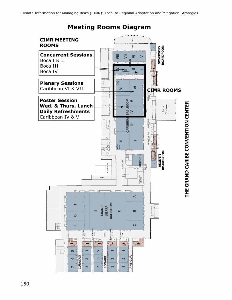
Climate Information for Managing Risks (CIMR): Local to Regional Adaptation and Mitigation Strategies
150
Meeting Rooms Diagram
Concurrent Sessions Boca I & II Boca III Boca IV
Plenary Sessions Caribbean VI & VII
Poster Session Wed. & Thurs. Lunch Daily Refreshments Caribbean IV & V
CIMR ROOMS
CIMR MEETING ROOMS