livingstone public land use zone · e[nq nq!s
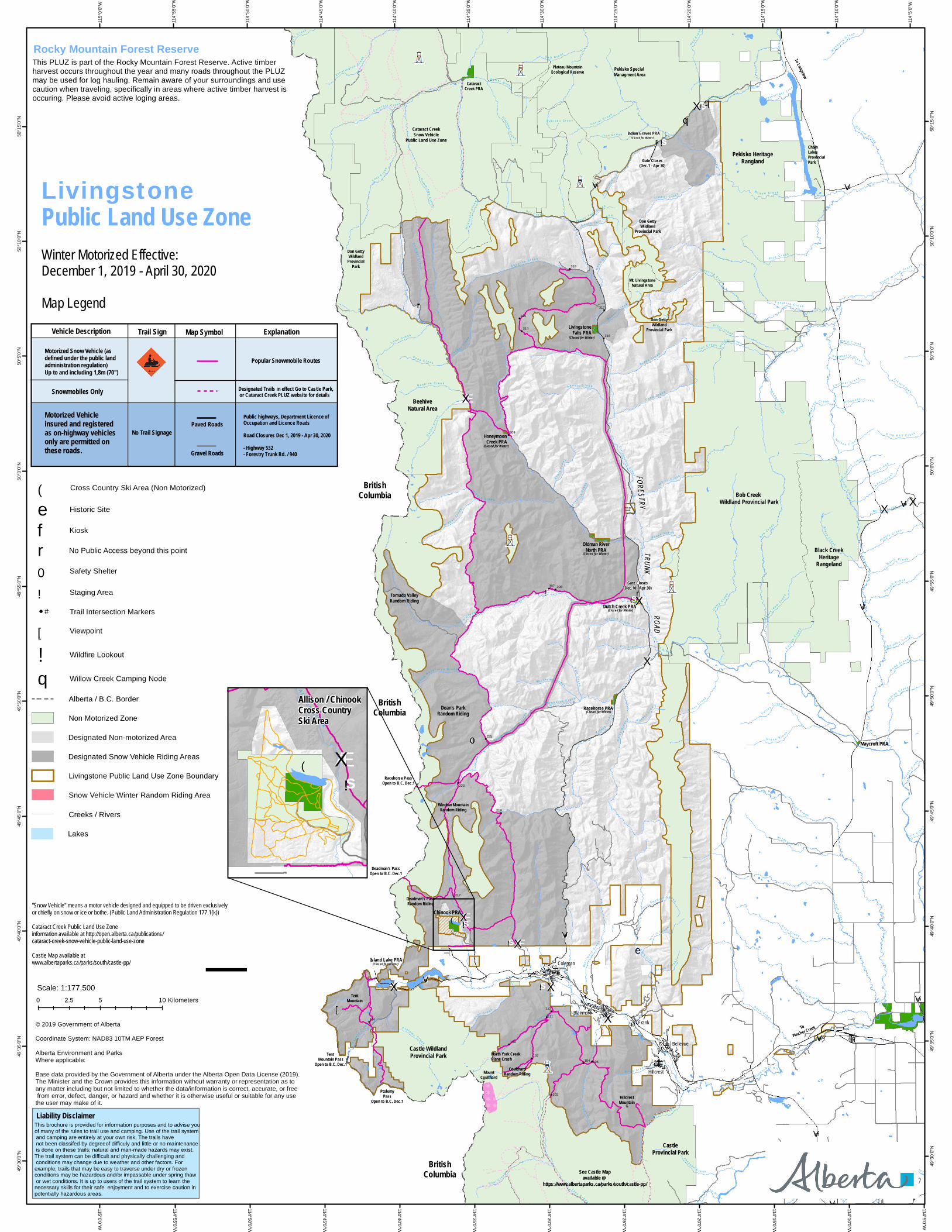
![!s!0 r Æx Æx Æx Æx Æx Æx Æx Æx Æx!s!s!s!s!!...

1
[ e n q n q ! S ! [ ! S ! 0 r Æ X Æ X Æ X Æ X Æ X Æ X Æ X Æ X Æ X ! S ! S ! S ! S ! S ! [ ! S ! 0 r Æ X Æ X Æ X Æ X Æ X Æ X n q ! S ! S r ! S r ! ( FORESTRY TRUNK ROAD ç ç U V Pekisko Heritage Rangland Hillcrest Bellevue Frank Blairmore Coleman North York Creek Plane Crash Cataract Creek PRA Plateau Mountain Ecological Reserve Indian Graves PRA Don Getty Wildland Provincial Park Don Getty Wildland Provincial Park Mt. Livingstone Natural Area Don Getty Wildland Provincial Park Beehive Natural Area British Columbia Bob Creek Wildland Provincial Park Black Creek Heritage Rangeland Chinook PRA Castle Wildland Provincial Park Castle Provincial Park Chain Lakes Provincial Park To Longview To Pincher Creek Dean's Park Random Riding Tornado Valley Random Riding Deadman's Pass Random Riding Tent Mountain Coulthard Random Riding Gate Closes (Dec.1 - Apr 30) Maycroft PRA Gate Closes (Dec.10 - Apr 30) (Closed for Winter) Private Lands Window Mountain Random Riding Island Lake PRA (Closed for Winter) Racehorse PRA (Closed for Winter) Dutch Creek PRA (Closed for Winter) Oldman River North PRA (Closed for Winter) Honeymoon Creek PRA (Closed for Winter) Livingstone Falls PRA (Closed for Winter) Cataract Creek Snow Vehicle Public Land Use Zone British Columbia British Columbia Racehorse Pass Open to B.C. Dec.1 Deadman's Pass Open to B.C. Dec.1 Ptolemy Pass Open to B.C. Dec.1 See Castle Map available @ https://www.albertaparks.ca/parks/south/castle-pp/ Mount Coulthard Hillcrest Mountain Tent Mountain Pass Open to B.C. Dec.1 Pekisko Special Managment Area 112 318 102 106 111 104 107 108 114 217 219 223 225 307 308 314 309 316 317 315 U V 22 U V 532 U V 533 U V 40 U V 3 U V 510 U V 520 U V 507 U V 3A U V 775 O l d m a n Ri v e r C r o w s n e s t R i ver T o d d Cr e e k W i l l o w C r e e k L iv i n g s t o n e Ri v e r C a l l u m C r e ek C o w C r e e k D u t c h C r e ek B o b C r e e k G o l d C r e e k C a s tl e R i v e r C a m p C r e e k V i c a r y C r e e k C a t a r a c t C r e e k L os t C r e e k R o c k C r e e k L y n x C r e e k C o n n ell y C r e e k D a i s y C r e e k L ang f o r d Cr e e k C h a f f e n C r e e k H id d e n C r e e k Y o r k C r eek R o s s C r e e k R i l e y C re e k W i l k i n s o n C r e e k W h ite C r e e k B l a i r m o re C r eek S t i m son C r e e k L y on s C r e ek R i c e C r e e k S a v a n n a C r e e k T i m b e r C r e e k W e s t ru p C r e e k N e ls o n C r e e k R a c e h or s e C r e ek S t a r C r e e k D e e p C r e e k W i l d c a t C reek D r y C r e e k C a c h e C r e e k G o a t C r e e k C o a t C r e e k T e tle y C r e e k Pek isko Cree k Ern s t C r e e k I r o n C r e e k B y r o n C r e e k C u m m i n g s C r e e k F l y C r e e k R i d g e C r e e k J o h n s o n Cr e e k D r u m C r e e k H a y C r e e k P t o l e m y C r e e k S a l t C r e e k S o u t h R a c eh o r s e C r e ek L y a ll C r e e k C r ow s n e s t C r eek J a c k s o n C r e ek T r out C r e e k Bi g J i m C r e e k P e l l e t i e r C r eek S p e e r s C r e ek I n d i a n C r e e k C or r a l C r e e k S t r a i g h t C r e e k B la c k C r e e k S l a c k e r C r e e k D a m o n Cr e e k E t h e r i ngton C r e e k Sa l t e r C r e e k N o r t h R a c e h o r s e Cre e k A d a i r C r e e k P l a t ea u C r e e k P l a y l e C r e e k N o rt h Cr e e k G ra v e Br o o k Hu n t e r C r e e k S o uth W i l l o w C r e e k M o r i n C r e ek P o o l e Cre e k M e a n C r e e k S t a t i on C r e e k C o y o t e C r e e k B e e h i v e Cr e e k B u r to n C r e e k B e a ver C r e ek S c r e w d r iv e r C r e e k S o d a C r e e k M e a d C r e e k W i n t e r i n g C r e e k Shal e C r e e k B e av e r d a m C r e e k L a s s i e C r e e k H a w k e y e Cr e e k Sou t h H i d d e n Cre e k W a r d C r e e k M o sq u i t o C r e e k M e i nsi n g er C r eek O w l C r e e k S n a k e C r e ek M i ll C r e e k B e a g le Cr e e k K i ng B o lt C r e ek P o c k e t C r e e k Gre e n Cr e e k S h a r pl e s C r e e k H e a t h Cr e e k N o r t h T w i n C r e e k C a u d r o n C r e e k L a n th ier C r e e k B a r i l C r e e k S o u t h T w i n C r e e k R a s p b e r r y C r ee k B ea v e r M in e s C r e e k O l i n C r e e k O'D o n n e l l Cr eek M a nys t i c k C r e e k C a r b o n d a l e Ri ver S a l t C r e e k U V 507 114°5'0"W 114°5'0"W 114°10'0"W 114°10'0"W 114°15'0"W 114°15'0"W 114°20'0"W 114°20'0"W 114°25'0"W 114°25'0"W 114°30'0"W 114°30'0"W 114°35'0"W 114°35'0"W 114°40'0"W 114°40'0"W 114°45'0"W 114°45'0"W 114°50'0"W 114°50'0"W 114°55'0"W 114°55'0"W 115°0'0"W 115°0'0"W 50°15'0"N 50°15'0"N 50°10'0"N 50°10'0"N 50°5'0"N 50°5'0"N 50°0'0"N 50°0'0"N 49°55'0"N 49°55'0"N 49°50'0"N 49°50'0"N 49°45'0"N 49°45'0"N 49°40'0"N 49°40'0"N 49°35'0"N 49°35'0"N 49°30'0"N 49°30'0"N ¯ Winter Motorized Effective: December 1, 2019 - April 30, 2020 Map Legend © 2019 Government of Alberta Coordinate System: NAD83 10TM AEP Forest Alberta Environment and Parks Where applicable: Base data provided by the Government of Alberta under the Alberta Open Data License (2019). The Minister and the Crown provides this information without warranty or representation as to any matter including but not limited to whether the data/information is correct, accurate, or free from error, defect, danger, or hazard and whether it is otherwise useful or suitable for any use the user may make of it. Livingstone Public Land Use Zone Æ X ! S ! S ! ( A l l i s o n C r e e k Allison / Chinook Cross Country Ski Area Historic Site e Kiosk ® f Safety Shelter ! 0 Viewpoint ! [ Staging Area ! S Wildfire Lookout ! n q Willow Creek Camping Node Alberta / B.C. Border Lakes Creeks / Rivers Snow Vehicle Winter Random Riding Area Cross Country Ski Area (Non Motorized) ! ( No Public Access beyond this point r Livingstone Public Land Use Zone Boundary Trail Intersection Markers # Non Motorized Zone Designated Non-motorized Area Designated Snow Vehicle Riding Areas Scale: 1:177,500 0 5 10 2.5 Kilometers This brochure is provided for information purposes and to advise you of many of the rules to trail use and camping. Use of the trail system and camping are entirely at your own risk, The trails have not been classifed by degreeof difficuly and little or no maintenance is done on these trails; natural and man-made hazards may exist. The trail system can be difficult and physically challenging and conditions may change due to weather and other factors. For example, trails that may be easy to traverse under dry or frozen conditions may be hazardous and/or impassable under spring thaw or wet conditions. It is up to users of the trail system to learn the necessary skills for their safe enjoyment and to exercise caution in potentially hazardous areas. Liability Disclaimer "Snow Vehicle" means a motor vehicle designed and equipped to be driven exclusively or chiefly on snow or ice or bothe. (Public Land Administration Regulation 177.1(k)) Cataract Creek Public Land Use Zone information available at http://open.alberta.ca/publications/ cataract-creek-snow-vehicle-public-land-use-zone Castle Map available at www.albertaparks.ca/parks/south/castle-pp/ Rocky Mountain Forest Reserve This PLUZ is part of the Rocky Mountain Forest Reserve. Active timber harvest occurs throughout the year and many roads throughout the PLUZ may be used for log hauling. Remain aware of your surroundings and use caution when traveling, specifically in areas where active timber harvest is occuring. Please avoid active loging areas. Vehicle Description Trail Sign Explanation Map Symbol No Trail Signage Motorized Vehicle insured and registered as on-highway vehicles only are permitted on these roads. Motorized Snow Vehicle (as defined under the public land administration regulation) Up to and including 1,8m (70'') Gravel Roads Paved Roads Public highways, Department Licence of Occupation and Licence Roads Road Closures Dec 1, 2019 - Apr 30, 2020 - Highway 532 - Forestry Trunk Rd. / 940 Popular Snowmobile Routes Designated Trails in effect Go to Castle Park, or Cataract Creek PLUZ website for details Snowmobiles Only

Upload: others

Post on 22-Mar-2020

17 views

Category:

Documents


0 download

TRANSCRIPT

[e

nq

nq

!S

![

!S

!0

r

ÆX

ÆX

ÆX

ÆX

ÆX

ÆX

ÆX

ÆX

ÆX

!S

!S

!S

!S

!S

![

!S

!0

r

ÆXÆX

ÆX

ÆX

ÆX

ÆX

nq

!S

!S

r

!Sr

!(

FORESTRYTRUNK

ROAD

ç

ç

UV94 0

Pekisko HeritageRangland

Hillcrest

Bellevue

FrankBlairmore

Coleman

North York Creek Plane Crash

CataractCreek PRA

Plateau MountainEcological Reserve

Indian Graves PRA

Don GettyWildland

Provincial Park

Don GettyWildland

ProvincialPark

Mt. LivingstoneNatural Area

Don GettyWildland

Provincial Park

BeehiveNatural Area

BritishColumbia Bob Creek

Wildland Provincial Park

Black CreekHeritage

Rangeland

Chinook PRA

Castle WildlandProvincial Park

CastleProvincial Park

ChainLakesProvincialPark

To Longview

ToPincher Creek

Dean's ParkRandom Riding

Tornado ValleyRandom Riding

Deadman's PassRandom Riding

TentMountain

CoulthardRandom Riding

Gate Closes(Dec.1 - Apr 30)

Maycroft PRA

Gate Closes(Dec.10 - Apr 30)

(Closed for Winter)

Private Lands

Window MountainRandom Riding

Island Lake PRA(Closed for Winter)

Racehorse PRA(Closed for Winter)

Dutch Creek PRA(Closed for Winter)

Oldman RiverNorth PRA(Closed for Winter)

HoneymoonCreek PRA

(Closed for Winter)

LivingstoneFalls PRA

(Closed for Winter)

Cataract CreekSnow Vehicle

Public Land Use Zone

BritishColumbia

BritishColumbia

Racehorse PassOpen to B.C. Dec.1

Deadman's PassOpen to B.C. Dec.1

PtolemyPass

Open to B.C. Dec.1

See Castle Mapavailable @

https://www.albertaparks.ca/parks/south/castle-pp/

MountCoulthard

HillcrestMountain

Tent Mountain Pass

Open to B.C. Dec.1

Pekisko Special Managment Area

112

318

102

106

111

104107

108

114

217

219

223

225

307 308

314

309

316

317

315

UV22

UV532 UV533

UV40

UV3

UV510

UV520

UV507

UV3A

UV775

Ol d m a n R i v e r

C r o w s n e s t R i v e r

T o d d C r e e k

W i l l o w C r e e k

L i v i n g s t o n eR i v e r C

a l l u mC

r e e k

C o wC

r e e k

D u t c h

C r e e k

B o b C r e e k

Go l d

C r e e k

C a s t l e R i v e r

C a m p

C r e e k

V i c a r yC r e

ek

C a t a r a c t C r e e k

L o s t C r ee k

R o c k C r e e k

L y n x C r e e k

C o n n e l l y C r e e k

Da i

s yC r e

e k

L a n g f o r d C r e e k

Ch a f f e nC r e e k

H i d d e n C r e e k

Yo r k

C r e e k

R o s s C r e e k

R i l e y C r e e k

Wi l

k in s

onC

r ee k

W h i t e C r e e k

B la i

r mo r e

C r ee k

S t i m s o n C r e e k

L y o n sC

r e e k

R i c e C r e e k

S a v a n n a C r e e k

T i m b e r C r e e k

W e s t r u p

C r e e k

N e l s o n C r e e k

R a c e h o r s e C r e e k

S t a r C r e e k

D e e p C r e e k

W i l d c a t C r e e k

D r y C r e e k

C a c he

Cr e

e k

G o a t C r ee k

C o a t C r e e k

T e t l e y

C r e e k

P e k i s k o C r e e k

E r n s t C r e e k

I r o n C r e e k

B y r o n C r e e k

Cu m m i n gs

Cr e e k

F l y C r e e k

R i d g e C r e e k

J o hns o

nC r e ek

D r u m C r e e k

H a yC r e

e k

P t o l e m y C r e e k

S a l tC

re e k

S o u t h R a c e h o r s eC r e

e k

L y a l l C r e e k

C r ow s n

e s t

C r e e k

J a c k s o n C r e e k

T r o u t C r e e k

B i g

J i m C r e e k

P e l l e t i e rC

r e e k

S p e e r s C r e e k

I n

d i a n C r e e k

C o r r a l C r e e k

S t r a i gh tC

r e e k

B l a c kC r e e k

S l ac k e r C r e e k

D a m o n C r e e k

E t h e r i n g t o n C r ee k

S a l t e r C r e e k

N o r t h

R a c e h o r s e C r e e k

A d a i r C r e e k

P l a t e a uC

r e e k

P l a y l e C r e e k

N o r t h C r e e k

G r a v e B r o o k

H u n t e r C r e e k

S o u t h W i l l o w C r e e k

Mo r i n C r e e k

P o o l e C r e e k

Me a n

C r ee k

S t a t i o n C r e e k

C o y o t eC r e

e k

B e e h i v e C r e e k

B u r t o n C r e e k

B e a v e r C r e e k

S c r e w d r i v e r C r e e k

S o d a C r e e k

M e a d C r e e k

W i n t e r i n g C r e e k

S h a l eC r

e ek

Bea v e r d a m

C r e e k

L a s si e

C r e e k

H a wk e

y e C r e e k

S o u t h H i d d e nC r e

e k

W a r d C r e e k

M o s q u i t oC r e e k

M e i n s i n g e r C r e e k

O w l C r e e k

S n a k e C r e e k

M i l l

C r e e k

B e a g l eC r e e k

K i n g B o l t C r e e k

P o c k e t C r e

e k

G r e e n C r e e k

S h a r p l e s C r e e k

H e a t hC r e e k

N o r t h T w i n C r e e k

C a u d r o n C r e e k

L a n t h i e r C r e e k

Ba r

i lC r e e k

S o u t h T w i n C r e e k

R a s p b e r r y C r e e k

B e a v e r M i ne s

C r e e k

O l i n C r ee k

O ' D o n n e l l C r e e k

M a n y s t i ck

Cr e

e k

C a rb o

n d a l e R i v e r

S a l t C r e e k

UV507 114°5'0"W

114°5

'0"W

114°10'0"W

114°1

0'0"W

114°15'0"W

114°1

5'0"W

114°20'0"W

114°2

0'0"W

114°25'0"W

114°2

5'0"W

114°30'0"W

114°3

0'0"W

114°35'0"W11

4°35'0

"W

114°40'0"W

114°4

0'0"W

114°45'0"W

114°4

5'0"W

114°50'0"W

114°5

0'0"W

114°55'0"W

114°5

5'0"W

115°0'0"W

115°0

'0"W

50°15

'0"N

50°15

'0"N

50°10

'0"N

50°10

'0"N

50°5'

0"N

50°5'

0"N

50°0'

0"N

50°0'

0"N

49°55

'0"N

49°55

'0"N

49°50

'0"N

49°50

'0"N

49°45

'0"N

49°45

'0"N

49°40

'0"N

49°40

'0"N

49°35

'0"N

49°35

'0"N

49°30

'0"N

49°30

'0"N

¯

Winter Motorized Effective:December 1, 2019 - April 30, 2020Map Legend

© 2019 Government of AlbertaCoordinate System: NAD83 10TM AEP ForestAlberta Environment and ParksWhere applicable:Base data provided by the Government of Alberta under the Alberta Open Data License (2019).The Minister and the Crown provides this information without warranty or representation as to any matter including but not limited to whether the data/information is correct, accurate, or free from error, defect, danger, or hazard and whether it is otherwise useful or suitable for any use the user may make of it.

LivingstonePublic Land Use Zone

ÆX

!S!S!(

A l l i s o nC r e e k

Allison / ChinookCross CountrySki Area

Historic Sitee

Kiosk®f

Safety Shelter!0

Viewpoint![

Staging Area!S

Wildfire Lookout!

nq Willow Creek Camping Node

Alberta / B.C. Border

Lakes

Creeks / Rivers

Snow Vehicle Winter Random Riding Area


Cross Country Ski Area (Non Motorized)!(

No Public Access beyond this pointr

Livingstone Public Land Use Zone Boundary

Trail Intersection Markers#

Non Motorized Zone

Designated Non-motorized Area

Designated Snow Vehicle Riding Areas

Scale: 1:177,5000 5 102.5 Kilometers

This brochure is provided for information purposes and to advise youof many of the rules to trail use and camping. Use of the trail system and camping are entirely at your own risk, The trails have not been classifed by degreeof difficuly and little or no maintenance is done on these trails; natural and man-made hazards may exist. The trail system can be difficult and physically challenging and conditions may change due to weather and other factors. Forexample, trails that may be easy to traverse under dry or frozen conditions may be hazardous and/or impassable under spring thaw or wet conditions. It is up to users of the trail system to learn the necessary skills for their safe enjoyment and to exercise caution inpotentially hazardous areas.

Liability Disclaimer

"Snow Vehicle" means a motor vehicle designed and equipped to be driven exclusivelyor chiefly on snow or ice or bothe. (Public Land Administration Regulation 177.1(k))Cataract Creek Public Land Use Zoneinformation available at http://open.alberta.ca/publications/cataract-creek-snow-vehicle-public-land-use-zoneCastle Map available atwww.albertaparks.ca/parks/south/castle-pp/

Rocky Mountain Forest ReserveThis PLUZ is part of the Rocky Mountain Forest Reserve. Active timberharvest occurs throughout the year and many roads throughout the PLUZmay be used for log hauling. Remain aware of your surroundings and usecaution when traveling, specifically in areas where active timber harvest isoccuring. Please avoid active loging areas.

Vehicle Description Trail Sign ExplanationMap Symbol

No Trail Signage

Motorized Vehicleinsured and registered as on-highway vehiclesonly are permitted onthese roads.

Motorized Snow Vehicle (asdefined under the public landadministration regulation)Up to and including 1,8m (70'')

Gravel Roads

Paved RoadsPublic highways, Department Licence ofOccupation and Licence RoadsRoad Closures Dec 1, 2019 - Apr 30, 2020- Highway 532- Forestry Trunk Rd. / 940

Popular Snowmobile Routes

Designated Trails in effect Go to Castle Park, or Cataract Creek PLUZ website for detailsSnowmobiles Only