livingstone- porcupine hills · burmis tree (a limber pine). ... porcupine hills areas also have a...
TRANSCRIPT
Livingstone- Porcupine Hills
Recreation Management Plan
Any comments, questions, or suggestions regarding the content of this document may be directed to:
Policy and Planning Division Planning Branch 3rd Floor, South Petroleum Plaza 9915 - 108 Street Edmonton, Alberta T5K 2G8
Call Toll Free Alberta: 310-3773 Toll Free: 1-877-944-0313
Email: [email protected] Media Inquires: [email protected] Website: http://aep.alberta.ca/
This document can be found at:
Recommended citation: Alberta Environment and Parks. 2017. Livingstone-Porcupine Hills Recreation Management Plan. Government of Alberta. ISBN No. 978-1-4601-3967-7. Available at: http://aep.alberta.ca/recreation-public-use/recreation-on-public-land/default.aspx ISBN 978-1-4601-3968-4
© 2018 Government of Alberta
Photo Credit: Sam Wirzba: cover image, page 14 and 32
ISBN 978-1-4601-3967-7 (Printed)ISBN 978-1-4601-3968-4 (PDF) Printed May 2018

Livingstone-Porcupine Hills | Recreation Management Plan i
EXECUTIVE SUMMARYThe Livingstone-Porcupine Hills Recreation Management Plan addresses the priorities for outdoor recreation expressed in the South Saskatchewan Regional Plan, which is within the traditional territory of Treaty 7. The South Saskatchewan Regional Plan prioritized planning for the Livingstone–Porcupine Hills areas as a region of high recreational use. It contains the headwaters of the Oldman River, supports biodiversity values, requires the management of wildlife risk and provides traditional First Nations land uses.
The Livingstone-Porcupine Hills area supports forestry, agriculture, mining and energy industries, in addition to outdoor recreation and tourism. Enhanced recreation management is required to thoughtfully manage the impacts of recreation on other land uses and ecological values. The Livingstone-Porcupine Hills Recreation Management Plan promotes sustainable outdoor recreation opportunities that support Albertans’ quality of life, diversify local economies and reduce conflicts across the landscape.
The Livingstone-Porcupine Hills Recreation Management Plan provides direction for recreational opportunities and management so that Albertans and visitors are able to enjoy these public lands responsibly. The plan also commits to monitoring and reporting on plan implementation and adapting as needed to address changing pressures and trends.
The plan also recognizes that partnerships and collaboration with stakeholders are essential to developing and delivering a recreation experience and management system that is ecologically sustainable and meets the varying needs of users.
The Livingstone-Porcupine Hills Recreation Management Plan commits to:
• Establishing a designated motorized trail system that meets the open motorized access limits prescribed by the Livingstone-Porcupine Hills Land Footprint Management Plan to protect watershed, biodiversity and other values.
• Developing best practices and guidelines for siting recreation infrastructure, including trails, camping and day use areas that:
- protect water bodies and riparian areas from sedimentation and damage;
- buffer critical wildlife habitat and ecologically sensitive areas;
- meet the needs of recreation users and promote positive experiences; and,
- identify timing restrictions, temporary closures and other measures to manage impacts to the environment and recreation infrastructure.

Livingstone-Porcupine Hills | Recreation Management Planii
• Improving recreation infrastructure, including installation of appropriate water crossings, upgrading trails and other recreation areas and providing enhanced camping opportunities, as resources permit.
• Formalizing existing and desired trails and supporting infrastructure for non-motorized recreation activities.
• Enhancing public use of recreation infrastructure through management strategies and actions.
• Enabling nature-based tourism opportunities where desired and appropriate.

Livingstone-Porcupine Hills | Recreation Management Plan iii
TABLE OF CONTENTSExecutive Summary ������������������������������������������������������������������������������������������������������������������������� i
1�0 Introduction ������������������������������������������������������������������������������������������������������������������������������1
1.1 Background and Context ...................................................................................................1
1.2 Strategic Nature of the Plan ...............................................................................................2
1.3 Vision ..................................................................................................................................3
1.4 Planning Area .....................................................................................................................4
1.5 Indigenous Values ..............................................................................................................5
2�0 Recreation Management Context ��������������������������������������������������������������������������������������������7
2.1 Legislative and Planning Context .......................................................................................7
2.2 Strategic Outcomes and Objectives ................................................................................12
2.3 Management Principles ....................................................................................................13
3�0 Issues and Opportunities �������������������������������������������������������������������������������������������������������15
3.1 Issues ...............................................................................................................................15
3.2 Opportunities ....................................................................................................................17
4�0 Recreation Management Direction - Livingstone and Porcupine Hills ��������������������������������19
4.1 Recreation, Biodiversity and Ecosystem Function ...........................................................19
4.2 Trails and Staging Areas ...................................................................................................23
4.3 Camping ...........................................................................................................................30
4.4 Nature-based Tourism, Scenic Areas and Viewpoints ......................................................34
4.5 Other Recreational Activities .............................................................................................36
4.6 Education ..........................................................................................................................39
4.7 Compliance and Public Safety ..........................................................................................40
4.8 Partnerships ......................................................................................................................42
5�0 Recreation Management Units: Livingstone and Porcupine Hills ����������������������������������������44
5.1 Livingstone Recreation Management Units ......................................................................46
5.1.1 Crowsnest Recreation Management Unit ...............................................................51
5.1.2 Livingstone Range Recreation Management Unit ...................................................52
5.1.3 Dutch-Oldman Recreation Management Unit .........................................................55
5.1.4 Willow Creek Recreation Management Unit ............................................................57

Livingstone-Porcupine Hills | Recreation Management Planiv
5.2 Porcupine Hills Recreation Management Unit ..................................................................59
5.3 Recreation Management Unit Strategies and Actions ......................................................62
5.4 Public Land Use Zone Maps ............................................................................................65
6.0 Performance Management ...................................................................................................66
6.1. Monitoring ........................................................................................................................66
6.2 Evaluation .........................................................................................................................68
6.3 Reporting and Plan Review ..............................................................................................69
7.0 Appendices ............................................................................................................................70
Appendix A: Glossary of Terms ..............................................................................................70
Appendix B: Planning and Public Engagement Process ........................................................76
Appendix C: References .........................................................................................................79

Livingstone-Porcupine Hills | Recreation Management Plan 1
1.0 INTRODUCTION1.1 Background and Context
The South Saskatchewan Regional Plan (2017) identifies the long-term vision1 for the region and the management intent for public land within the Green Area (Figure 1). As part of management intent for the Green Area, the Government of Alberta aims to provide a diversity of outdoor recreation opportunities while recognizing that recreation occurs within a multiple use landscape with complex environmental, economic and social values.
The Government of Alberta is changing its approach to recreation management on public land. Recreation management plans enable the government to work with partners and recreation users to improve sustainability of the recreation infrastructure system and provide the experience Albertans and visitors are seeking. The plan recognizes that access to natural spaces improves residents’ and visitors’ sense of place and connection to nature, which enhances quality of life
1 Note to Readers: The bolded words have definitions provided in the Acronym and Glossary Appendix. The bolded words are bolded once upon first use of the word.
Figure 1: Green Area of the South Saskatchewan Region

Livingstone-Porcupine Hills | Recreation Management Plan2
and promotes stewardship of Alberta’s public land. The physical, spiritual and mental benefits of outdoor recreation are widely recognized as essential for health2. Public lands provide an opportunity for Albertans and visitors to benefit from all that outdoor recreation offers. With a management plan in place, managing recreation on public lands will be undertaken in a way which assures Albertans that public lands can be enjoyed for recreation and that opportunities will be provided for future nature-based tourism and economic diversification in southwest Alberta.
1.2 Strategic Nature of the Plan
The South Saskatchewan Regional Plan outlines the strategic direction of the Government of Alberta for managing recreation within the Livingstone and Porcupine Hills Public Land Use Zones (Figure 2). This will assist government staff and stakeholders in operationalizing the Livingstone-Porcupine Hills Recreation Management Plan. This includes:
• Direction on the sustainable development and management of a recreation system.
• Allowable recreational uses of the public lands within the planning areas by the public.
• Identification of recreation and tourism opportunities in the planning areas.
• Location of trails available for motorized and non-motorized recreation use.
• Future use of the public lands and the recreation infrastructure within the planning areas by tourism operators and/or developers.
• Strategies and actions to enhance management of public use of the planning area’s recreation infrastructure.
• Actions that need to be undertaken to support recreation activities.
This plan is sufficiently flexible so that future proposals within the prescribed allowable uses may be considered. Implementation is subject to available resources and project prioritization both within the planning area and throughout the region.
2 A Framework for Recreation in Canada - 2015 - Pathways to Wellbeing.

Livingstone-Porcupine Hills | Recreation Management Plan 3
Figure 2: Porcupine Hills and Livingstone Public Land Use Zones
“The scenic and well-managed landscapes of the Livingstone and Porcupine Hills regions, and their abundant wildlife, thriving populations of native fish, inspiring vistas, and unique Indigenous and rural ways of life, will provide Albertans and our visitors with a diversity of recreational opportunities which connect us to the natural environment. Recreational users will find adventure, challenge, solitude, escape, and wonder that reflects the living diversity of Alberta’s southern foothills and mountains and the stewardship ethic that sustains the landscape.”
1.3 Vision
Albertans and visitors to the Livingstone and Porcupine Hills Public Lands Use Zones are able to experience a broad variety of outdoor recreation and nature-based tourism opportunities. The vision for recreation management in the Livingstone and Porcupine Hills areas is:
The vision is supported by outcomes and objectives (Section 2.2, Table 3) and specific management actions and strategies (Section 4-5, Tables 4-12).

Livingstone-Porcupine Hills | Recreation Management Plan4
1.4 Planning Area
The Livingstone-Porcupine Hills planning area includes portions of four municipalities: The Municipal Districts of Ranchland No. 66, Willow Creek No. 26, Pincher Creek No. 9 and the Municipality of Crowsnest Pass. The Towns of Nanton, Stavely, Claresholm, Granum, and Fort Macleod are east of the planning areas, while the Village of Cowley and the Town of Pincher Creek are located to the south. Peigan Timber Limit “B” Reserve Lands and Piikani Reserve No. 147, including the Piikani community Brocket, are south and east of the planning area. The Blood Reserve No. 148 is to the southeast and the Eden Valley Reserve No. 216 is located to the north. Finally, the City of Lethbridge is the largest populated centre in the vicinity of the Porcupine Hills, approximately 100 kilometres east-southeast of the planning area.
The Livingstone area is comprised of the headwaters of the Oldman River, Dutch Creek, and Racehorse Creek, to the Livingstone Range, with the strip of Green Area along the North Burmis Road and south of the Crowsnest Pass to the Castle Provincial Park and Castle Wildlands Provincial Park. The area is located between the British Columbia (BC) border in the west to Highway 22 in the east and from the Castle Parks border in the south to Highway 532 in the north. It encompasses approximately 1398 km2 of public land in the Green Area. (Figure 2). The Porcupine Hills are found east of the Livingstone Range, between Highway 22 (also called the Cowboy Trail) and Highway 2, south toward Peigan Timber Limit “B”, and north toward Highway 533. The Porcupine Hills comprise approximately 392 km2 of public land in the Green Area of Alberta.
The Livingstone and Porcupine Hills areas form important components of the Crown of the Continent ecosystem which covers approximately 72,000 km2 of land along the shared Rocky Mountain borders of Alberta, British Columbia and Montana. It is an area recognized internationally for its rich biodiversity and diverse landscapes that range from prairies to mountain peaks. The Livingstone area includes the headwater basins of the Oldman and Livingstone rivers. The Livingstone and Porcupine Hills have a diverse array of flora and fauna including the well-known landmark and local icon – the Burmis Tree (a limber pine). There are several legislated species at risk in the area, including westslope cutthroat trout, bull trout, grizzly bear, limber and whitebark pine. Native rough fescue grasslands grow throughout the planning area.
The Livingstone-Porcupine Hills area has been an important landscape for Indigenous Peoples. A strong First Nations cultural connection to the area continues today as treaty rights are exercised and various traditional uses of the area continue, including spiritual and ceremonial activities, and food and medicinal plant collection. The Livingstone and Porcupine Hills areas also have a long history of logging, mining and providing rangeland for local ranchers to graze cattle. The area has also supported the oil and gas sector.
Limber Pine
Livingstone-Porcupine Hills | Recreation Management Plan 5
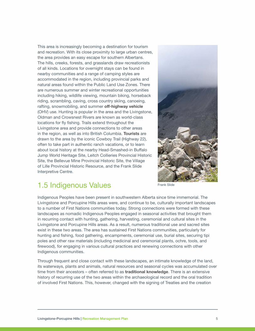
Frank Slide
This area is increasingly becoming a destination for tourism and recreation. With its close proximity to large urban centres, the area provides an easy escape for southern Albertans. The hills, creeks, forests, and grasslands draw recreationists of all kinds. Locations for overnight stays can be found in nearby communities and a range of camping styles are accommodated in the region, including provincial parks and natural areas found within the Public Land Use Zones. There are numerous summer and winter recreational opportunities including hiking, wildlife viewing, mountain biking, horseback riding, scrambling, caving, cross country skiing, canoeing, rafting, snowmobiling, and summer off-highway vehicle (OHV) use. Hunting is popular in the area and the Livingstone, Oldman and Crowsnest Rivers are known as world-class locations for fly fishing. Trails extend throughout the Livingstone area and provide connections to other areas in the region, as well as into British Columbia. Tourists are drawn to the area by the iconic Cowboy Trail (Highway 22), often to take part in authentic ranch vacations, or to learn about local history at the nearby Head-Smashed-in Buffalo Jump World Heritage Site, Leitch Collieries Provincial Historic Site, the Bellevue Mine Provincial Historic Site, the Village of Lille Provincial Historic Resource, and the Frank Slide Interpretive Centre.
1.5 Indigenous Values
Indigenous Peoples have been present in southwestern Alberta since time immemorial. The Livingstone and Porcupine Hills areas were, and continue to be, culturally important landscapes to a number of First Nations communities today. Strong connections were formed with these landscapes as nomadic Indigenous Peoples engaged in seasonal activities that brought them in recurring contact with hunting, gathering, harvesting, ceremonial and cultural sites in the Livingstone and Porcupine Hills areas. As a result, numerous traditional use and sacred sites exist in these two areas. The area has sustained First Nations communities, particularly for hunting and fishing, food gathering, encampments, ceremonial use, burial sites, securing tipi poles and other raw materials (including medicinal and ceremonial plants, ochre, tools, and firewood), for engaging in various cultural practices and renewing connections with other Indigenous communities.
Through frequent and close contact with these landscapes, an intimate knowledge of the land, its waterways, plants and animals, natural resources and seasonal cycles was accumulated over time from their ancestors – often referred to as traditional knowledge. There is an extensive history of recurring use of the two areas within the archaeological record and the oral tradition of involved First Nations. This, however, changed with the signing of Treaties and the creation
Livingstone-Porcupine Hills | Recreation Management Plan6
3 A pattern of movement from one resource-gathering area to another in a cycle that was followed each year.
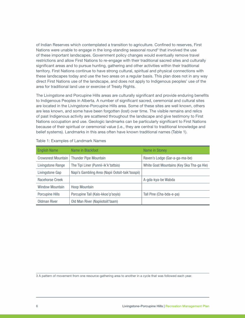
English Name Name in Blackfoot Name in Stoney
Crowsnest Mountain Thunder Pipe Mountain Raven’s Lodge (Gar-a-ga-ma-be)
Livingstone Range The Tipi Liner (Punnii-ik’k’tattsis) White Goat Mountains (Key Ska Tha-ga Hie)
Livingstone Gap Napi’s Gambling Area (Napii Ootsit-taik’tssspii)
Racehorse Creek A-gda-kya-be Wabda
Window Mountain Hoop Mountain
Porcupine Hills Porcupine Tail (Kais-kkoo’p’soyis) Tall Pine (Cha-bda-e-pa)
Oldman River Old Man River (Napiiotsiit’taam)
of Indian Reserves which contemplated a transition to agriculture. Confined to reserves, First Nations were unable to engage in the long-standing seasonal round3 that involved the use of these important landscapes. Government policy changes would eventually remove travel restrictions and allow First Nations to re-engage with their traditional sacred sites and culturally significant areas and to pursue hunting, gathering and other activities within their traditional territory. First Nations continue to have strong cultural, spiritual and physical connections with these landscapes today and use the two areas on a regular basis. This plan does not in any way direct First Nations use of the landscape, and does not apply to Indigenous peoples’ use of the area for traditional land use or exercise of Treaty Rights.
The Livingstone and Porcupine Hills areas are culturally significant and provide enduring benefits to Indigenous Peoples in Alberta. A number of significant sacred, ceremonial and cultural sites are located in the Livingstone-Porcupine Hills area. Some of these sites are well known, others are less known, and some have been forgotten (lost) over time. The visible remains and relics of past Indigenous activity are scattered throughout the landscape and give testimony to First Nations occupation and use. Geologic landmarks can be particularly significant to First Nations because of their spiritual or ceremonial value (i.e., they are central to traditional knowledge and belief systems). Landmarks in this area often have known traditional names (Table 1).
Table 1: Examples of Landmark Names

Livingstone-Porcupine Hills | Recreation Management Plan 7
2.0 RECREATION MANAGEMENT CONTEXT2.1 Legislative and Planning Context
Plan Authority
The Livingstone-Porcupine Hills Recreation Management Plan came into effect May 14, 2018. Under the Land-use Framework, the Government of Alberta has affirmed an enhanced Integrated Resource Management System that sets out a new approach for managing the province’s land and natural resources. Regional priorities, outcomes and direction are established through regional plans. The South Saskatchewan Regional Plan (SSRP) came into effect September 1, 2014 (amended February 2017) and the Government of Alberta committed to numerous strategies within southern Alberta, including issue-specific planning, such as recreation management planning. This Recreation Management Plan becomes effective in accordance with Section 13(5) of the Alberta Land Stewardship Act as an issue-specific sub-regional plan under the South Saskatchewan Regional Plan.
The Public Lands Act and the Public Lands Administration Regulation provide for the management and use of vacant public land and public land under disposition in Alberta. The Recreation Management Plan is further supported by a wide array of provincial legislation, regulations, provincial policy, directives, and codes of practice which are implemented through a full range of both regulatory and non-regulatory tools. One key tool is the Livingstone-Porcupine Hills Land Footprint Management Plan, which provides direction for the Livingstone-Porcupine Hills Recreation Management Plan by setting limits and thresholds for motorized access density including roads and trails.
The second key tool required to provide for activities in appropriate places and enable compliance efforts is a Public Land Use Zone. These are regulatory instruments that are established on Alberta public lands, under Public Land Administration Regulations, to provide those activities and any accompanying enforcement authority. Public Land Use Zones for the Livingstone-Porcupine Hills areas were established effective May 14, 2018.
The pre-existing Livingstone-Porcupine Hills Sub-Regional Integrated Resource Plan (1987) has been providing land use and resource management direction for the planning area. There are 42 provisions that are addressed by the Recreation Management Plan. The Integrated Resource Plan will remain in effect until all provisions have been reviewed for their relevance and incorporated as appropriate under the implementation strategies of sub-regional planning or issue-specific plans in the region.
Livingstone-Porcupine Hills | Recreation Management Plan8
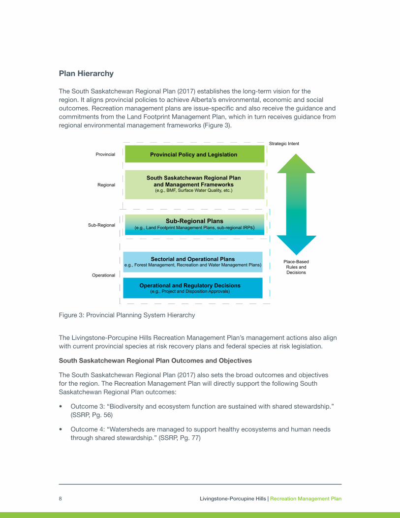
Plan Hierarchy
The South Saskatchewan Regional Plan (2017) establishes the long-term vision for the region. It aligns provincial policies to achieve Alberta’s environmental, economic and social outcomes. Recreation management plans are issue-specific and also receive the guidance and commitments from the Land Footprint Management Plan, which in turn receives guidance from regional environmental management frameworks (Figure 3).
The Livingstone-Porcupine Hills Recreation Management Plan’s management actions also align with current provincial species at risk recovery plans and federal species at risk legislation.
South Saskatchewan Regional Plan Outcomes and Objectives
The South Saskatchewan Regional Plan (2017) also sets the broad outcomes and objectives for the region. The Recreation Management Plan will directly support the following South Saskatchewan Regional Plan outcomes:
• Outcome 3: “Biodiversity and ecosystem function are sustained with shared stewardship.” (SSRP, Pg. 56)
• Outcome 4: “Watersheds are managed to support healthy ecosystems and human needs through shared stewardship.” (SSRP, Pg. 77)
Figure 3: Provincial Planning System Hierarchy
Provincial Policy and Legislation
South Saskatchewan Regional Planand Management Frameworks(e.g., BMF, Surface Water Quality, etc.)
Sub-Regional Plans(e.g., Land Footprint Management Plans, sub-regional IRPs)
Sectorial and Operational Planse.g., Forest Management, Recreation and Water Management Plans)
Operational and Regulatory Decisions(e.g., Project and Disposition Approvals)
Provincial
Regional
Sub-Regional
Operational
Strategic Intent
Place-BasedRules andDecisions

Livingstone-Porcupine Hills | Recreation Management Plan 9
• Outcome 6: “The quality of life of residents is enhanced through increased opportunities for outdoor recreation and the preservation and promotion of the regions unique cultural and natural heritage.” (SSRP, Pg. 91)
In addition, the Recreation Management Plan will contribute to:
• Outcome 1: “The region is positioned as a world-class, year-round, tourism destination.” (SSRP, Pg. 50)
The South Saskatchewan Regional Plan identifies biodiversity and healthy, functioning ecosystems as key priorities for sub-regional planning. Specifically, these are:
• headwaters protection,
• conservation of biodiversity and sensitive habitat, including connectivity,
• mitigation of wildfire risk, including public safety and ecosystem health, and,
• integrated and coordinated use of public land.
The outcomes, objectives and priorities of the Recreation Management Plan for Livingstone-Porcupine Hills align with the outcomes and objectives of the South Saskatchewan Regional Plan and apply them to the unique local values and landscapes of these areas.
Alignment with the Land Footprint Management Plan
In the Livingstone and Porcupine Hills, recreation use is one of the main contributors to human footprint. The Livingstone-Porcupine Hills Land Footprint Management Plan provides direction to this plan in managing two components of footprint: i) motorized access, and ii) spatial human footprint (Figure 3). Most notably, the direction received from the Land Footprint Management Plan relates to disturbance limits on motorized access, particularly on Open Motorized Access which means roads or trails, of any width or type, permitted for ongoing public use. There is also a disturbance limit on Near-stream Motorized Access which applies to all motorized access – including motorized trails – that occur on erodible soils within 100 metres of a watercourse.
The mandatory integrated land management practices outlined in the Land Footprint Management Plan include:
• Develop recreation management plan(s) with outcomes and objectives that align with the Eastern Slopes priorities in the South Saskatchewan Regional Plan and with the Footprint Plan. Recreation management planning will demonstrate the application of integrated land management, including the siting criteria identified in Section 2.3 of the Land Footprint Management Plan and also compatibility factors that consider the needs of other land users and adjacent land owners to public lands; coordinated access planning (and subsequent approval) of recreation and tourism activity will meet thresholds established in the Land Footprint Management Plan:
- Access corridors for motorized recreation are coordinated with other sectors and adhere to motorized access limits and are considered Open Motorized Access.

Livingstone-Porcupine Hills | Recreation Management Plan10
• Motorized camping nodes, staging areas, recreation infrastructure are assessed for their contribution to Spatial Human Footprint and managed to meet open motorized access targets of 0.4km/km2 within Zone 2 and 0.6km/km2 within Zone 3. Coordinated access planning and development of non-motorized recreation must also adhere to mandatory integrated land management, particularly siting criteria to minimize the effects of footprint on sensitive areas.
• Alberta Environment and Parks may close or restrict motorized and non-motorized access to protect ecological values, to ensure public safety, or for management purposes (e.g. during periods of heavy rainfall, thin snowpack for snowmobiles, or for wildfire risk or species management requirements).
• Minimize the impact of recreational motorized access to wildlife through key mountain passes in partnership with Parks and authorities in British Columbia.
Access coordination mechanisms:
Footprint management planning in the Livingstone-Porcupine Hills area requires a proactive and coordinated approach by the Government of Alberta. Access coordination is led by department land managers and disposition regulators and enables all sectors to manage motorized access to sustainable, long-term levels that are below the disturbance limits. The Land Footprint Management Plan provides the following guidance to access coordination efforts, including access provided in the Recreation Management Plan:
• The Land Footprint Management Plan requires that footprint be assessed as a condition of approval.
• Land managers and regulators must operate with a common objective to minimize footprint.
• Operational plans must understand the motorized needs of the respective activity and how it contributes to the overall motorized access levels in the sub region. The Land Footprint Management Plan allocates motorized access such that new industrial activity will have precedence over public motorized recreation.
• The Government of Alberta recognizes that the lack of certainty regarding a potential threat to the environment should not be used as a reason for not taking action to avert the risk of serious or irreversible harm to the environment.
Castle Provincial Park and Castle Wildland Provincial Park
In 2017, the Government established two parks in the Castle area, the Castle Provincial Park and the Castle Wilderness Provincial Park. These two parks are managed through the Castle Management Plan – Castle Provincial Park and Castle Wildland Provincial Park (draft 2018). The Castle parks are to be managed as world-class protected places that allow Albertans and visitors to experience this unique ecological area. As part of Alberta’s park system, recreation and tourism opportunities will include infrastructure for non-motorized trails, campgrounds

Livingstone-Porcupine Hills | Recreation Management Plan 11
and day use facilities. The Castle Provincial Park will provide Albertans and visitors the primary location for front-country nature-based experiences and also provide access to park services including educational and interpretive programs, information and visitor support. The Castle Wildlands Provincial Park will focus on low-impact backcountry and wilderness experiences including trails and backcountry huts.
On its southern border, the Livingstone Public Land Use Zone is directly adjacent to the Castle Provincial Park and the Castle Wildlands Provincial Park. The Recreation Management Plan will complement the direction set in the Castle Parks plan for outdoor recreation. The direction and management intent of the Castle Parks plan will be taken into consideration to ensure all Albertans and visitors to the region have a broad array of activities and recreation styles to choose from. Integrated planning will occur to ensure trail systems are designed with the management intent of all areas in mind, and to take advantage of the tremendous opportunity to develop and maintain interconnected trail networks that showcase the beauty and uniqueness of the region.
Recreation and Other Land Uses
A recreation system will be developed in the two Public Land Use Zones in future years. A designated system reduces risk for all land uses and users by ensuring everyone is aware of what activities are occurring and where, along with the ability to manage incompatible uses.
The South Saskatchewan Regional Plan recognizes the economic value of this land for multiple sectors and this plan supports maintaining the multi-use function of these Public Land Use Zones. The development and designation of recreation infrastructure will be done with consideration of compatibility between desired activities and existing land uses, including industrial, forestry and agricultural uses. These designations are done with the understanding that while public lands are working landscapes where resource extraction continues to provide a number of essential economic benefits to Albertans, recreation and tourism increasingly provide important economic benefits too. Designations for recreation infrastructure will not occur where the impacts of recreation on the commercial, industrial or agricultural use will cause unnecessary risk to public or disposition holders, nor will designations contravene any existing land use commitment. Within the working land context however, there is a need to protect and enhance recreation infrastructure and amenity values, and protect them from avoidable damage or loss so as to retain their economic and social value. While the Government of Alberta recognizes that some disposition holders may be effected by this plan, the government is committed to ensuring that these effects are mitigated. In particular, existing commitments in the regional plan to avoid conversion and maintain intact native grasslands and to continue the commitment to stocking rates currently in effect, will be upheld..
Potential impacts to the continued exercise of treaty rights, and to plant and animal communities supporting continued traditional land use, and protection of culturally important areas, should be considered when designating and/or developing recreation and tourism related infrastructure. Designation of new trails and development of recreation infrastructure will require assessment by Alberta Culture and Tourism to determine if historical resources are present and if the recreational activity may have impact to those resources.
Livingstone-Porcupine Hills | Recreation Management Plan12
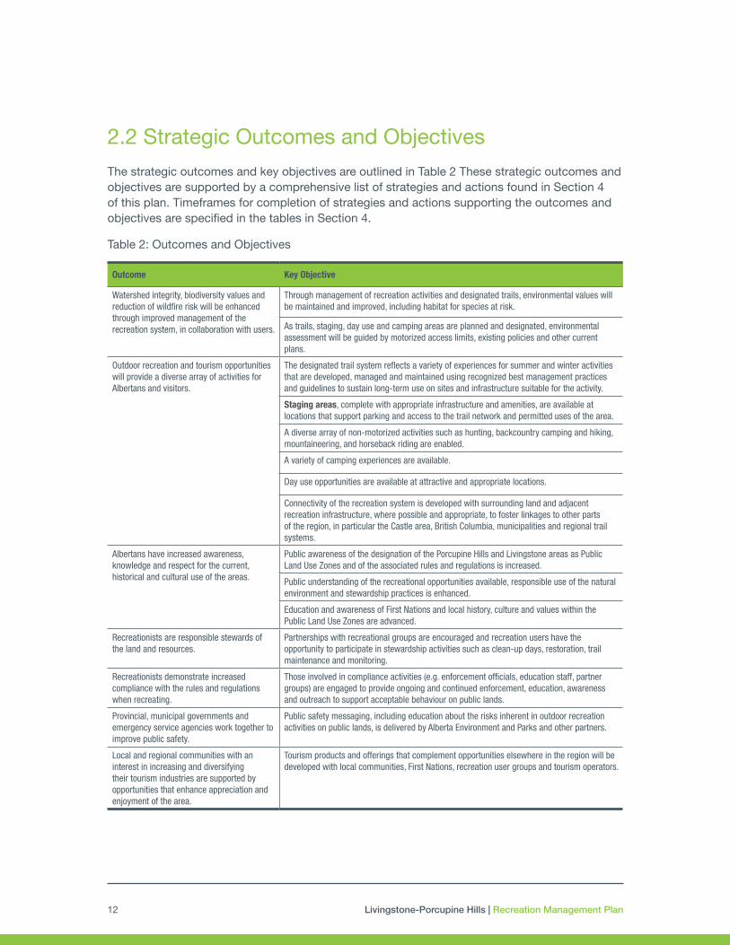
2.2 Strategic Outcomes and Objectives
The strategic outcomes and key objectives are outlined in Table 2 These strategic outcomes and objectives are supported by a comprehensive list of strategies and actions found in Section 4 of this plan. Timeframes for completion of strategies and actions supporting the outcomes and objectives are specified in the tables in Section 4.
Table 2: Outcomes and Objectives
Outcome Key Objective
Watershed integrity, biodiversity values and reduction of wildfire risk will be enhanced through improved management of the recreation system, in collaboration with users.
Through management of recreation activities and designated trails, environmental values will be maintained and improved, including habitat for species at risk.
As trails, staging, day use and camping areas are planned and designated, environmental assessment will be guided by motorized access limits, existing policies and other current plans.
Outdoor recreation and tourism opportunities will provide a diverse array of activities for Albertans and visitors.
The designated trail system reflects a variety of experiences for summer and winter activities that are developed, managed and maintained using recognized best management practices and guidelines to sustain long-term use on sites and infrastructure suitable for the activity.
Staging areas, complete with appropriate infrastructure and amenities, are available at locations that support parking and access to the trail network and permitted uses of the area.
A diverse array of non-motorized activities such as hunting, backcountry camping and hiking, mountaineering, and horseback riding are enabled.
A variety of camping experiences are available.
Day use opportunities are available at attractive and appropriate locations.
Connectivity of the recreation system is developed with surrounding land and adjacent recreation infrastructure, where possible and appropriate, to foster linkages to other parts of the region, in particular the Castle area, British Columbia, municipalities and regional trail systems.
Albertans have increased awareness, knowledge and respect for the current, historical and cultural use of the areas.
Public awareness of the designation of the Porcupine Hills and Livingstone areas as Public Land Use Zones and of the associated rules and regulations is increased.
Public understanding of the recreational opportunities available, responsible use of the natural environment and stewardship practices is enhanced.
Education and awareness of First Nations and local history, culture and values within the Public Land Use Zones are advanced.
Recreationists are responsible stewards of the land and resources.
Partnerships with recreational groups are encouraged and recreation users have the opportunity to participate in stewardship activities such as clean-up days, restoration, trail maintenance and monitoring.
Recreationists demonstrate increased compliance with the rules and regulations when recreating.
Those involved in compliance activities (e.g. enforcement officials, education staff, partner groups) are engaged to provide ongoing and continued enforcement, education, awareness and outreach to support acceptable behaviour on public lands.
Provincial, municipal governments and emergency service agencies work together to improve public safety.
Public safety messaging, including education about the risks inherent in outdoor recreation activities on public lands, is delivered by Alberta Environment and Parks and other partners.
Local and regional communities with an interest in increasing and diversifying their tourism industries are supported by opportunities that enhance appreciation and enjoyment of the area.
Tourism products and offerings that complement opportunities elsewhere in the region will be developed with local communities, First Nations, recreation user groups and tourism operators.

Livingstone-Porcupine Hills | Recreation Management Plan 13
2.3 Management Principles
Management Principles were created based on input from stakeholders and First Nations, cross-jurisdictional best practices, and staff expertise. They are to be considered and upheld in all aspects of planning, implementation and evaluation of outdoor recreation management within the Livingstone and Porcupine Hills Public Land Use Zones.
1. Outdoor recreation activities and the development of associated nature-based tourism opportunities is a significant land use in Porcupine Hills and Livingstone.
2. Sustainable best management practices that support biodiversity, ecological health and watershed integrity underlies the development of all outdoor recreation infrastructure, including trails, staging areas, day use areas and tourism developments.
3. Decisions on recreation land use are evidence-based. Indigenous ecological knowledge and ways of knowing are considered alongside western scientific perspectives in management decisions.
4. The “5 Es of management”4, engineering, education, enforcement, evaluation, and experience, are employed in the implementation of this plan. (Figure 4)
5. Recreation management is appropriately integrated with other land uses by land managers and impacts from and between recreation and other land uses will be managed. The Porcupine Hills and Livingstone areas exist within a broader landscape of public lands, First Nations lands, private lands, parks, and municipal lands. Respecting and cultivating the relationships across all lands and communities is necessary to strengthen their health and vitality.
6. Public recreation trails, day use and staging infrastructure are considered public resources and are not designated for long-term exclusive use.
7. Public safety within the designated trail and camping system is a shared responsibility.
5 “Es” of Recreation Management
Engineering – Designing and constructing the facilities to address environmental, economic or social interests and values.
Education – Informing participants about what is expected, important and interesting.
Enforcement – Ensuring compliance with rules and regulations.
Evaluation – Making sure actions are accomplishing goals and addressing issues.
Experience – Ensuring that the needs of the users are met in a way that creates a positive experience.
Figure 4. 5 “Es” of Recreation Management
4 Adapted from the NOHVCC Management Guidelines for OHV Recreation, 2006.

Livingstone-Porcupine Hills | Recreation Management Plan14
8. Activities and partnerships that enhance stewardship are encouraged and enabled.
9. Recreational use, management actions and management objectives are actively monitored and evaluated. A monitoring program will be designed and used to address emerging needs.

Livingstone-Porcupine Hills | Recreation Management Plan 15
3.0 ISSUES AND OPPORTUNITIES3.1 Issues
Key issues have been derived from conversations with a broad range of stakeholders, First Nations and experts within the Government of Alberta.
1. Environmental:
• Damage to watersheds (especially riparian areas), landscape degradation and scarring to forested areas and grasslands, including headwaters and areas containing sensitive species such as limber pine, and rough foothills fescue grasslands.
• Wildlife and wildlife habitat disturbance, including streams bearing westslope cutthroat trout, bull trout, grizzly bear habitat, and migration pathways of bighorn sheep, mountain goats, elk, and deer.
• Terrestrial and aquatic invasive species spreading along trails, camping and staging areas, and along waterways.
• Wildfire risk from recreational use.
• Soil erosion during rainfall and runoff events.
• Human waste and garbage.
2. Social:
• Increasing population and pursuit of leisure activities leading to more pressure from recreational activities on public land.
• Anticipated additional pressure from motorized recreation and random camping due to increase in activity and to changes in management intent in other regions and jurisdictions.
• Public resistance and opposition to changes to the status quo resulting from the creation of new protected areas, establishment of Public Land Use Zones, setting trail density limits, and the development of recreation plans.
• Disturbance and/or destruction of cultural and heritage sites (known and unknown).
• Illegal activities, including: exceeding the 14-day camping limit, littering, dumping of human waste, cutting of trees, etc.
• Public safety issues including: difficulty in undertaking evacuations as a result of recreational activities, improperly extinguished campfires, drinking and driving, unsafe operation of motorized vehicles, injuries from non-motorized activities, swift water rescues, irresponsible use of firearms, etc.
Livingstone-Porcupine Hills | Recreation Management Plan16
• Conflict between recreation use and landowners including: noise disturbances, wildlife displacement (onto private land), property damage, trespassing, and vandalism.
• Conflict between recreationists participating in incompatible recreation activities.
• Integrating recreation, as a new formal land use, with existing land uses and activities.
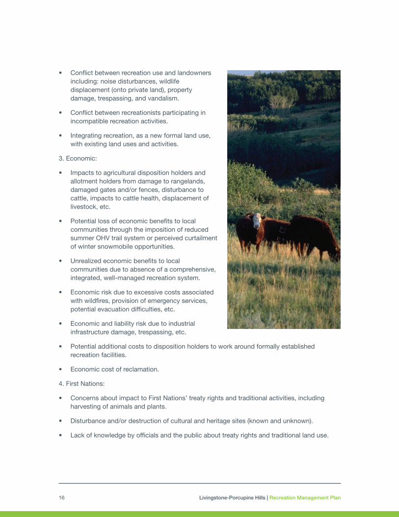
3. Economic:
• Impacts to agricultural disposition holders and allotment holders from damage to rangelands, damaged gates and/or fences, disturbance to cattle, impacts to cattle health, displacement of livestock, etc.
• Potential loss of economic benefits to local communities through the imposition of reduced summer OHV trail system or perceived curtailment of winter snowmobile opportunities.
• Unrealized economic benefits to local communities due to absence of a comprehensive, integrated, well-managed recreation system.
• Economic risk due to excessive costs associated with wildfires, provision of emergency services, potential evacuation difficulties, etc.
• Economic and liability risk due to industrial infrastructure damage, trespassing, etc.
• Potential additional costs to disposition holders to work around formally established recreation facilities.
• Economic cost of reclamation.
4. First Nations:
• Concerns about impact to First Nations’ treaty rights and traditional activities, including harvesting of animals and plants.
• Disturbance and/or destruction of cultural and heritage sites (known and unknown).
• Lack of knowledge by officials and the public about treaty rights and traditional land use.

Livingstone-Porcupine Hills | Recreation Management Plan 17
3.2 Opportunities
As well as issues raised by a broad range of stakeholders, First Nations and experts within the Government of Alberta, key opportunities were also identified. These include:
1. Environmental:
• There is opportunity to develop partnerships and share information so that Albertans and visitors can learn about the ecology and geology of the area, including information about species at risk, environmental stewardship, historical land use, etc.
• Enhanced management of public land use supports preservation of environmental goods and services: clean water, soil stability, ecosystem resiliency, carbon sequestration, landscape and plant biodiversity.
• The presence of rich natural resources that provide opportunities for nature-based tourism and nature-dependent recreation activities.
• The presence of spectacular landscapes that provide opportunities for people to discover Alberta’s natural heritage and ecological diversity.
2. Social:
• The Porcupine Hills are accessible through five main points and are centrally located to a large regional population.
• The highways and municipal roads through the Livingstone provides access to Wildland and Provincial Parks, and Natural Areas.
• Spectacular scenic byways and viewpoints can provide day use and educational opportunities.
• The Livingstone area offers a number of mixed-use recreational activities.
• There is opportunity to develop partnerships, information, and resources for Albertans and visitors to learn about ranching culture and local history.
• There is opportunity to develop partnerships, information, and resources for Albertans and visitors to learn about and participate in recreational stewardship, connect to nature, etc.
• Enhancing access to nature for all Albertans provides substantive mental and physical health benefits.

Livingstone-Porcupine Hills | Recreation Management Plan18
3. Economic:
• There is opportunity to partner with municipalities to leverage the area as an important hub for outdoor recreation with an already well established tourism market for snowmobilers, hiking, cross country skiing and mountain biking.
• There is opportunity to develop facilities and infrastructure to support nature-based tourism and increase all-season recreational activities to enhance visitation.
• Outdoor recreation and tourism can generate demand for more businesses to provide goods and services, creating employment, attracting investment, contributing to government revenues and enhancing the desirability of communities.
• The growth of tourism in the region can support economic diversification by supporting growth in other sectors such as transportation, retail, construction and agriculture.
4. First Nations:
• There is opportunity to develop partnerships, information, and resources for Albertans and visitors to learn about First Nations history, culture and current socio-cultural practices.
• There are opportunities to develop Indigenous-focused tourism.

Livingstone-Porcupine Hills | Recreation Management Plan 19
4.0 RECREATION MANAGEMENT DIRECTION – LIVINGSTONE AND PORCUPINE HILLSThe eight topics presented below outline the general management intent, strategies and actions that, as they are completed, will build the recreation system across the Livingstone and Porcupine Hills.
Each topic in this section contains two parts:
• Management Intent: Builds on the strategic intent of the plan and provides the direction for each management topic or theme. The management intent is supported by specific objectives, strategies and actions that describe the ways in which the Government of Alberta and its partners will meet the outcomes described in Section 2.2 (Table 3).
• Objectives, Action and Strategies: Recognizing that implementation will occur incrementally over a period of years, the strategies and actions support reaching or delivering upon the associated objective. These objectives, when achieved, will collectively result in reaching the desired outcomes.
Timeframes for all strategies and actions are provided to ensure timely implementation of this plan. All timeframes start from the date the plan is approved. They are generally defined for this section as:
• Short Term: one to three years
• Medium Term: four to seven years
• Long Term: seven to 10+ years
• Ongoing: Implemented immediately upon plan approval or short term and continuing forward
4.1 Recreation, Biodiversity and Ecosystem Function
Management Intent
The public use of landscapes, especially unmanaged use, can have significant impacts on watershed integrity and biodiversity. While the management of all recreation is to be carried out in a manner that supports sustainable use of public lands, several key shifts are required to ensure maintenance and improvement of environmental values over time within the Livingstone and Porcupine Hills areas. These include:

Livingstone-Porcupine Hills | Recreation Management Plan20
• Reducing human footprint to sustainable limits. While all recreational activities have a footprint, motorized vehicles have the greatest impact on wildlife, water quality and hydrology, livestock, adjacent landowners, and other use. The open motorized access limits, as described by the Land Footprint Management Plan, support ecosystem function, and also align with direction for species of concern, including grizzly bear, westslope cutthroat trout, white bark and limber pine, and native grasslands. Limits to motorized access and appropriate trail siting also reduces the spread of invasive species, addresses noise concerns, and relieves conflict among users.
• Designating motorized use. Impacts from unpredictable use by recreation users are significant for wildlife, particularly ungulate species and wide-roaming carnivores, as well as livestock. Designated trails allow wildlife and livestock to become accustomed to the patterns of human use, learn to avoid designated areas and generally decrease stress responses in wildlife populations and livestock.
• Construction of trail water course crossings. Bridges and culverts will eventually be constructed over all water bodies on designated trails. This will include building properly designed approaches and prioritizing investment in crossings within habitat for westslope cutthroat trout and bull trout. These measures will reduce sedimentation to waterbodies and limit impacts to fisheries populations.
• Development and implementation of standards and best practices: Requirements for location, design and use of recreation infrastructure will mitigate the impacts of recreation on sensitive areas, species of concern, wildlife corridors and other natural resource values. These include (for example):
- Shifting current camping away from riparian areas and meadows containing native or modified native grasslands, to less sensitive areas.
- Re-routing trails to reduce the number of water crossings and away from highly erodible soils.
- Timing restrictions to address sensitive periods for livestock and wildlife (e.g. calving seasons, ground nesting season) and wet time periods with high soil erosion potential.
- Avoiding high value wildlife corridors wherever feasible.
Species at Risk Recovery Plans
The Recreation Management Plan for the Livingstone and Porcupine Hills will be an important tool to enable action towards specific recovery measures in
Westslope cutthroat trout
Livingstone-Porcupine Hills | Recreation Management Plan 21
Species Recovery Plans, such as for westslope cutthroat trout, grizzly bear, limber pine, and other species at risk. Impacts to species at risk and appropriate mitigation measures must be considered when managing recreation activities.
Invasive Species Management
Controlling invasive species is a critical strategy for maintaining healthy ecosystems and biodiversity on the landscape. Recreation infrastructure system design, placement and maintenance, as well as partnerships and public education, will help manage invasive species, in particular invasive plants. All equipment for building and maintaining recreational infrastructure, and all recreational vehicles, and other equipment, such as fishing gear, trailers and footwear should follow best practices for preventing the spread of aquatic and terrestrial invasive species. Other plans and policies, including the Land Footprint Management Plan and species recovery plans, provide guidance and requirements for invasive species management.
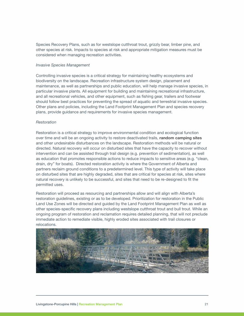
Restoration
Restoration is a critical strategy to improve environmental condition and ecological function over time and will be an ongoing activity to restore deactivated trails, random camping sites and other undesirable disturbances on the landscape. Restoration methods will be natural or directed. Natural recovery will occur on disturbed sites that have the capacity to recover without intervention and can be assisted through trail design (e.g. prevention of sedimentation), as well as education that promotes responsible actions to reduce impacts to sensitive areas (e.g. “clean, drain, dry” for boats). Directed restoration activity is where the Government of Alberta and partners reclaim ground conditions to a predetermined level. This type of activity will take place on disturbed sites that are highly degraded, sites that are critical for species at risk, sites where natural recovery is unlikely to be successful, and sites that need to be re-designed to fit the permitted uses.
Restoration will proceed as resourcing and partnerships allow and will align with Alberta’s restoration guidelines, existing or as to be developed. Prioritization for restoration in the Public Land Use Zones will be directed and guided by the Land Footprint Management Plan as well as other species-specific recovery plans including westslope cutthroat trout and bull trout. While an ongoing program of restoration and reclamation requires detailed planning, that will not preclude immediate action to remediate visible, highly eroded sites associated with trail closures or relocations.

Livingstone-Porcupine Hills | Recreation Management Plan22
Table 3: Recreation, Biodiversity and Ecosystem Function Strategies and Actions
Objective
Through management of recreation activities and designated trails, environmental values will be maintained and improved, including habitat for species at risk.
Strategy/Action Timeline Lead
Westslope Cutthroat Trout and Fish Habitat
a. Designated motorized trails that cross fish bearing water bodies will have a water course crossing. Priority will be for westslope cutthroat critical habitat.
b. Interim measures will be adopted in priority areas on designated motorized and non-motorized trails to mitigate sedimentation until crossings can be constructed, e.g. closing or rerouting crossings, placement of matting to prevent erosion, etc.
c. Non-motorized trails that are impacting fish habitats will be mitigated to reduce sedimentation to the waterbody.
d. Motorized access for angling purposes to sensitive westslope cutthroat trout populations may be restricted for conservation purposes.
Short Term and Ongoing
Alberta Environment and Parks (AEP), Operations Division
Strategy/Action Timeline Lead
Whitebark and Limber Pine
e. Design trails to avoid cutting down limber/whitebark pine.
f. Install education and interpretative signage at key trails/staging areas on whitebark and limber pine in coordination with species at risk recovery plans.
Short Term AEP, Operations Division
Native and Modified Native Grasslands
g. Siting of trails to minimize impacts to native and modified native grasslands. Trails through rough fescue will be left to a minimum distance possible and be placed where there are existing disturbances.
h. Camping areas will be assessed and prioritized to be moved or redesigned in such a manner to avoid impact to native and modified native grasslands wherever feasible.
i. Education and interpretative signage will be installed at key trails/staging areas around native grasslands coordination with species at risk recovery plans.
Short Term AEP, Operations Division
Wildlife
j. Designated trails will be designed to avoid critical wildlife habitat and wildlife corridors. If trails are located in important wildlife areas, appropriate mitigation will be completed or the trail will be closed. Appropriate mitigation includes siting in areas that minimize impact as well as seasonal, specific timing restrictions or minimize the length of trail through the area.
Short Term and Ongoing
AEP, Operations Division
Invasive Species
k. Engage Alberta Invasive Species Council for education and outreach and to work with user groups and the public, including potential to provide education and interpretative signage at key locations.
l. Use a risk management approach to target species of concern, avoid unintended consequence and to utilize resources in an effective and efficient manner.
m. Monitor trails/staging areas for the spread of invasive plants and remove/control when necessary or to comply with the Weed Control Act.
n. Collaborate with municipalities on invasive species to raise awareness (themed around the “Play, Clean, Go” messaging).
o. Explore potential funding or partnerships opportunities to install vehicle wash stations.
Medium Term and Ongoing
AEP, Operations Division, Agriculture and Forestry
Livingstone-Porcupine Hills | Recreation Management Plan 23
Objective
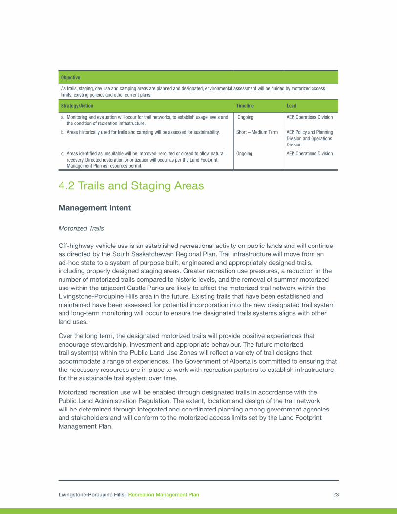
As trails, staging, day use and camping areas are planned and designated, environmental assessment will be guided by motorized access limits, existing policies and other current plans.
Strategy/Action Timeline Lead
a. Monitoring and evaluation will occur for trail networks, to establish usage levels and the condition of recreation infrastructure.
Ongoing AEP, Operations Division
b. Areas historically used for trails and camping will be assessed for sustainability. Short – Medium Term AEP, Policy and Planning Division and Operations Division
c. Areas identified as unsuitable will be improved, rerouted or closed to allow natural recovery. Directed restoration prioritization will occur as per the Land Footprint Management Plan as resources permit.
Ongoing AEP, Operations Division
4.2 Trails and Staging Areas
Management Intent
Motorized Trails
Off-highway vehicle use is an established recreational activity on public lands and will continue as directed by the South Saskatchewan Regional Plan. Trail infrastructure will move from an ad-hoc state to a system of purpose built, engineered and appropriately designed trails, including properly designed staging areas. Greater recreation use pressures, a reduction in the number of motorized trails compared to historic levels, and the removal of summer motorized use within the adjacent Castle Parks are likely to affect the motorized trail network within the Livingstone-Porcupine Hills area in the future. Existing trails that have been established and maintained have been assessed for potential incorporation into the new designated trail system and long-term monitoring will occur to ensure the designated trails systems aligns with other land uses.
Over the long term, the designated motorized trails will provide positive experiences that encourage stewardship, investment and appropriate behaviour. The future motorized trail system(s) within the Public Land Use Zones will reflect a variety of trail designs that accommodate a range of experiences. The Government of Alberta is committed to ensuring that the necessary resources are in place to work with recreation partners to establish infrastructure for the sustainable trail system over time.
Motorized recreation use will be enabled through designated trails in accordance with the Public Land Administration Regulation. The extent, location and design of the trail network will be determined through integrated and coordinated planning among government agencies and stakeholders and will conform to the motorized access limits set by the Land Footprint Management Plan.

Livingstone-Porcupine Hills | Recreation Management Plan24
Trail Classification for Motorized Use
Summer motorized trails will be classified by vehicle type in the short term (OHV and Single Track). As designated trails are assessed and upgraded as required, the designation will shift to a vehicle width based system. This system will use a combination of notice (through Public Land Use Zone maps) and signage, as well as physical barriers to only permit vehicles that meet the designated width. This system will be based on the current Alberta Recreation Corridors and Trails Classification System, or provincial policy that may be implemented in the future. Additional measures may be implemented with regards to trail classification and managing access of vehicle types.
Noise
Noise from motorized recreational activity can affect adjacent land owners, other recreational users, livestock and wildlife. To reduce site-specific noise impacts on neighboring landowners, the following mitigation measures will be considered: spatial buffers, motorized trail placement in locations that naturally reduce or muffle sound, timing restrictions, etc. (Table 4). It is recommended that provincial policy options are explored, such manufacturing standards for OHVs that lead to reduction of operating noise at the time of production, enhanced regulation around aftermarket modifications that increase noise emissions and standards to guide noise mitigation on public lands.
Buffers of a minimum of two kilometres between the location of existing private residences and designated motorized trails will be put in place with the objective of reducing noise impacts from motorized recreation. The Crowsnest Pass Recreation Management Unit trails will consider the location of private residences, but due to size of the area and proximity of the municipality, some smaller buffers may be required at specific locations to align with the intent of recreation management regarding proposed staging, camping and potential Public Land Recreation Areas.
Off-Road Capable Highway Vehicles (Trucks, 4x4s, Jeeps, SUVs, etc.)
The use of 4 wheeled on-highway vehicles for off-road activity is both a traditional way to access the backcountry and a recreational activity. However, these vehicles are

Livingstone-Porcupine Hills | Recreation Management Plan 25
challenging to manage off road due their overall size and power, that allows them to reach places smaller off highway vehicles cannot, with resulting environmental damage.
Extreme use trails, areas for bouldering or rock climbs, as well as technical trails with obstacles requiring specialized vehicle modification (e.g. snorkels, low pressure or other high traction tires) will not be designated nor will such use be permitted. On-highway vehicles will continue to have access to all publicly accessible roads in the region. The department will explore options for limited trail access within the Livingstone and Porcupine Hills to enable continued access to traditional land use areas for First Nations elders as well for access to recreational opportunities, where such trails can be engineered and maintained to be sustainable long term.
Single Track Trails for Motorbike Use
Single-track only trails are desired by motorbike riders who are seeking challenging trails, including narrow trails, winding paths, trail obstacles and/or steep inclines and declines.
Due to the small area of the Porcupine Hills, the designated motorized trail network will, in the future, permit both OHVs and single track vehicles on all designated motorized trails. It will also include a limited single track network. The system will be designed to avoid impacts to environmental values in particular native and modified native grasslands, limber pine, and westslope cutthroat trout. The design will also address impacts to adjacent landowners, forestry and grazing activities.
The Livingstone area can potentially support a more diverse range of single track options. These opportunities will need to be built and maintained with partners in the future to reflect the specialized needs and considerations of this activity. In addition to any designated single track specific trails that may be identified in the future, motorbike riders will have access to all other designated motorized trails during the summer period unless otherwise restricted.
Winter Trails
Snowmobiling in the Livingstone is a well-established and popular recreational activity. In the Porcupine Hills it occurs when there is sufficient snowpack.
Winter motorized use is generally seen as compatible with the overall resource values and outcomes for both areas. Management direction for winter snowmobile use include:

Livingstone-Porcupine Hills | Recreation Management Plan26
• Snow vehicles will be required to stay on designated trails or within designated random ride areas.
• Critical wildlife habitat, as represented by Key Wildlife and Biodiversity Zones dataset maintained by Alberta Environment and Parks, will be avoided by snow vehicle trails or may be subject to timing restrictions.
• Future snow vehicle trails and infrastructure within critical wildlife habitat for ungulates will require assessment by wildlife biologists and other experts to determine appropriate extent, time and location.
• Unless otherwise indicated by Public Land Use Zone maps, signs or notice, trails for snow vehicles will be permitted from December 1 – April 30.
• Partnerships for grooming trails, maintaining safety shelters and clearing winter staging areas will be formalized with trail groups and municipalities.
As funding and partnerships permit, options for warming huts may be explored in suitable locations. These structures can provide shelter along long interconnected trail systems or in backcountry locations for safety.
Snow and ice bridges are generally permissible within the Livingstone area for winter recreation trails where existing bridges are not in place. The use of snow bridges may be limited in specific locations if impacts to sensitive water bodies are occurring.
Non-Motorized Trails
Non-motorized recreational use of the Porcupine Hills and Livingstone is an important, long-standing use of the area. The region contains important travel routes for First Nations, and some of the earliest trails in the region were created by ranchers to move livestock. Trails are used for a variety of activities including: hiking, biking, horseback riding, snowshoeing and cross-country skiing. Mountain biking in particular is a growing sector that has a strong community and organized support. Non-motorized trails also offer important access for other activities including: hunting, fishing, mountaineering, berry picking, wildlife viewing, viewscape photography and backpacking. The overall management intent is to continue to enable non-motorized activity throughout Porcupine Hills and Livingstone except where land use commitments, public safety

Livingstone-Porcupine Hills | Recreation Management Plan 27
risks or sensitive environmental issues would prohibit such access.
Recreation trails on public lands exist as two types:
Unintentional - Existing Trails: are created as a result of industrial exploration, industrial access, cumulative trail use or other linear disturbance which receive public use.
Intentional - Designated Trails: are created when Environment and Parks issues a disposition for the trail, develops a sub-regional or recreation management plan and specifies the trails as designated, posts signs or notices in Public Land Use Zones and on vacant public land, approves notations for the purposes of a recreation management plan, or approves a disposition reservation.
Currently, there are only unintentional non-motorized trails in this area, however there is desire for designated non-motorized infrastructure (staging, amenities, trail development, water crossings etc.) in the future. The Department will be working with partners to designate specific high use non-motorized trails in the Public Land Use Zones starting in 2019.
Significant trails, including managed networks (e.g. hiking, skiing, biking), those that provide connectivity to staging areas, viewpoints, cultural or natural landscape features or are destination trails (e.g., Great Divide Trail), will receive appropriate designation. Heavily used designated trails will require improvements to an established trail standard. Supporting infrastructure, including staging areas, signage, or hut to hut systems may be established as funding and partnerships permit. Partners will be enabled to develop formalized trails where appropriate.
Equestrian use will continue within the Livingstone and Porcupine Hills Public Land Use Zones and is allowed on and off the designated trails unless otherwise indicated by sign or notice. Public trails may continue to be used by equestrian commercial operators, subject to the same rules and regulations as the public at large. Alberta Environment and Parks policy for the issuance of commercial trail riding permits will continue to be followed. Trails will not be available for long term exclusive commercial use. Privately developed trails under an appropriate disposition will allow for public access.

Livingstone-Porcupine Hills | Recreation Management Plan28
Mountain Biking
Mountain biking is a growing use within the region, with both approved trails and informal routes existing on public lands. The location of mountain bike trails, is important, with most mountain bikers preferring to ride within a relatively short distance from a well-developed and highly accessible staging area or community. The most popular mountain bike areas are currently located in or near the Municipality of Crowsnest Pass. Cooperation and coordination among the municipality, local trail groups and the Government of Alberta will be required to successfully and sustainably support this use. Separation of hiking, equestrian and mountain bike trails will be required in heavily used areas designed for specific users (e.g. people who downhill mountain bike).
A mountain bike strategy was previously developed for the Crowsnest Pass by interested parties. A dedicated mountain bike trail network (and skills park) already exists at the Pass Powderkeg. Mountain bikers are also using existing trails for mountain biking on public land that surrounds the municipality. As participation levels in mountain biking grows, the Government of Alberta, partners and stakeholders will explore options to locate, designate, build and maintain technical trails. These trail networks will be located in suitable areas within the Public Land Use Zones and will be built to sustainable best management practices. In particular, the government will work with trail groups to develop an “epic ride” as defined by the International Mountain Biking Association, which would connect the Castle parks and the Livingstone Public Land Use Zone.
The strategies and actions below support the identified objectives. These objectives, when achieved, collectively will result in reaching the desired outcomes described in Section 2.2 (Table 2).
5 As per BC’s Outdoor Access Guide and Access Management Areas for Alexander Creek, Corbin Creek and Chauncey Todhunter

Livingstone-Porcupine Hills | Recreation Management Plan 29
Objective
The designated trail system reflects a variety of experiences for summer and winter activities that are developed, managed and maintained using recognized best management practices and guidelines to sustain long-term use on sites and infrastructure suitable for the activity.
Strategy/Action Timeline Lead
General Trails Strategies and Actions
a. Ensure new trails are designed and classified following the Alberta Recreation Corridors and Trail Classification System and the Minimizing Risk and Liability best practices or future guidelines as may be developed by the province.
b. Establish partnerships with stakeholders for development, maintenance and/or monitoring of the trail system. Systems managed or maintained by local clubs will require authorization.
c. Establish buffers to minimize and avoid impacts to adjacent private landowners, including noise and trespass. Standard provincial guidelines will be developed for buffer specifications.
d. Work with stakeholders to develop and maintain an appropriate trail difficultly rating system.
e. Align timing restrictions of cross border trails with the timing restriction in BC. Alberta’s designated trails into BC will be signed and access limited at appropriate locations away from the BC border to limit illegal access during period of restriction5.
f. Employ seasonal (timing) restrictions imposed to mitigate disturbance to wildlife, be responsive to high fire risk and wet conditions, consider livestock entry into Forest Reserve allotments, or address noise considerations where required.
g. Build or maintain trail access to key cultural, historic and scenic features.
Ongoing
Ongoing
Ongoing
Medium-Long Term
Short Term
Short Term
Ongoing
AEP, Operations Division
AEP, Operations Division
AEP, Operations Division, Trail Groups
AEP, Operations Division, Policy and Planning Division
AEP, Operations Division, Trail Groups
AEP, Operations Division
AEP, Operations Division
AEP, Operations Division
Summer Motorized Trails Strategies and Actions
h. Complete inventory and assessment of existing motorized trails
i. Seek shared road use agreements with municipalities and industry disposition holders to accommodate OHV use on select municipal road segments and select disposition roads that connect designated OHV trails.
Short Term
Short Term
AEP, Operations Division
AEP, Operations Division
Winter Motorized Trails Strategies and Actions
j. Establish a winter designated trail network and random sledding areas.
k. Consider future random ride sledding areas for designation in consultation with local snowmobile groups.
l. Enable groups to groom specified snowmobile trails through an authorization. Restrictions may be placed on groomer size where bridge crossings are required.
m. Restrict use of groomed trails to vehicles meeting the definition of a snowmobile, as defined by the Motor Vehicle Safety Regulation CRC c1038 made pursuant to the Motor Vehicle Safety Act (1993, c.16).
n. Explore opportunities with land managers and disposition holders to enable winter use of municipal and other disposition roads for snow vehicle use, where those roads are not maintained for on-highway vehicle traffic in winter.
Short Term
Medium Term
Ongoing
Short Term
Ongoing
AEP, Operations Division
AEP, Operations Division, Snowmobile groups
AEP, Operations Division, Snowmobile groups
AEP, Operations Division
AEP, Operations Division
Table 4: Trails and Staging Strategies and Actions

Livingstone-Porcupine Hills | Recreation Management Plan30
Objective
Staging areas, complete with appropriate infrastructure and amenities, are available at locations that support parking and access to the trail network and permitted uses of the area.
Strategy/Action Timeline Lead
a. Work with partners to maintain year round access to key roads and staging areas.
b. Identify staging areas to support the designated trail systems and dispersed recreation use.
Long Term
Ongoing
AEP, Operations Division
AEP, Operations Division
Objective
Connectivity of the recreation system is developed with surrounding land and adjacent recreation infrastructure, where possible and appropriate, to foster linkages to other parts of the region, in particular the Castle area, British Columbia, municipalities and regional trail systems.
Strategy/Action Timeline Lead
a. Enable opportunities for interconnected and diverse multi-use trails systems for a full range of recreation activities that promote multi-day trips/tours which include or lead to or connect key attractions and communities.
b. Identify non-motorized trail networks that connect to the region’s parks and protected areas.
Long Term
Short Term
AEP, Alberta C&T, Municipalities
AEP
Strategy/Action Timeline Lead
Non-motorized Trails Strategies and Actions
o. Initiate inventory and assessment of existing non-motorized trails.
p. Designate non-motorized trails to ensure trails are recognized on the landscape and are built in the best locations.
q. Identify locations for a hut-to-hut concept that could be established by third parties to provide a diverse backcountry experience. Huts could facilitate hiking on long, interconnected trail systems or in popular backcountry climbing areas.
r. Explore options for technical mountain bike trails.
s. Work with user groups to enable grooming of identified trails for cross country skiing.
Medium Term
Short Term
Medium-Long Term
Medium Term
Ongoing
Non-motorized trail groups, AEP, Operations Division
AEP, Operations Division
AEP, Operations Division, Stakeholders and Parks Division
Mountain Bike Groups
AEP, Operations Division, Cross Country Ski Groups

Livingstone-Porcupine Hills | Recreation Management Plan 31
Backcountry Camping
Camping that typically requires some travel from highway, OHV trail or road access, which may involve hiking, boating, riding or being accompanied by pack animals and utilizes a tent, sleeping bag or tarp for sleeping.
Rustic Motorized Camping
Camping with a recreational vehicle (RV) or camping unit designed to be towed on or behind a motorized vehicle within a designated area with limited or no services or amenities.
Figure 6. Camping definitions
4.3 Camping
Backcountry Camping
Backcountry or tent camping will continue to be permitted throughout the two Public Land Use Zones unless there is a risk to public safety, environmentally sensitive areas requiring restrictions (e.g. wildlife corridors), incompatibility with adjacent activity, or existing dispositions issued under the Public Lands Act prohibit public access. Camping is generally not permitted on designated trails.
Motorized Camping
Motorized camping is managed to address the concerns associated with random motorized camping, lessen impacts to the environment and to promote desirable camping experiences.
Rustic Motorized Camping
Rustic motorized camping will occur in established designated locations (described to the side). Existing camping sites will be assessed for environmental concerns and if required, moved to more suitable locations over time. Restoration work will be undertaken where it is most needed, as sites are designated. Riparian areas, terrestrial critical habitat for threatened fish species like westslope cutthroat trout and bull trout and areas containing native grasslands, will be avoided and camping areas moved to less sensitive areas over time. Future rustic motorized camping areas will have a defined boundary and the Government of Alberta will conduct ongoing monitoring to assess use and sustainability of these sites.
Rustic Camping Zones – various sized camping zones that are near roads and or trails. Their length and size will vary, with some allowing campers to be more dispersed and some providing for group camping.
• Best practices for siting camping zones will be created and include consideration for setbacks from water and riparian areas, safe approaches, surfacing, and considerations for critical wildlife habitat and other sensitive areas.
• These sites will be non-serviced.

Livingstone-Porcupine Hills | Recreation Management Plan32
Figure 7: Rustic Motorized Camping Areas
Public Land Recreation Areas – small designated areas that serve as hubs for camping, trail access, day use and staging for non-motorized access. These areas are designated under the Public Lands Administration Regulation and have additional regulations to promote safe use.
• The proposed areas (see Figure 7 for concept locations) are located in existing high use areas, many of which were identified in South Saskatchewan Regional Plan.
• Fires are permitted only within facilities provided for such use within Public Land Recreation Areas, or as in accordance with Section 6 of the Forest and Prairie Protection Regulation.
• Garbage disposal, outhouses and information kiosks will be provided. The sites will be upgraded as needed to manage more intense use. Other amenities may be developed in collaboration with partners.
A phased approach to managing motorized camping will be used. While inventory, assessment and further engagement occurs, motorized camping will continue as is. As sites are identified, mapped and signed, they will be shared via Public Land Use Zones maps, kiosks and online.
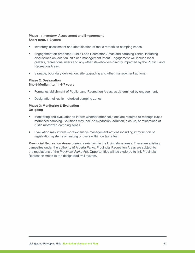
Livingstone-Porcupine Hills | Recreation Management Plan 33
Phase 1: Inventory, Assessment and Engagement Short term, 1-3 years
• Inventory, assessment and identification of rustic motorized camping zones.
• Engagement on proposed Public Land Recreation Areas and camping zones, including discussions on location, size and management intent. Engagement will include local grazers, recreational users and any other stakeholders directly impacted by the Public Land Recreation Areas.
• Signage, boundary delineation, site upgrading and other management actions.
Phase 2: Designation Short-Medium term, 4-7 years
• Formal establishment of Public Land Recreation Areas, as determined by engagement.
• Designation of rustic motorized camping zones.
Phase 3: Monitoring & Evaluation On-going
• Monitoring and evaluation to inform whether other solutions are required to manage rustic motorized camping. Solutions may include expansion, addition, closure, or relocations of rustic motorized camping zones.
• Evaluation may inform more extensive management actions including introduction of registration systems or limiting of users within certain sites.
Provincial Recreation Areas currently exist within the Livingstone areas. These are existing campsites under the authority of Alberta Parks. Provincial Recreation Areas are subject to the regulations of the Provincial Parks Act. Opportunities will be explored to link Provincial Recreation Areas to the designated trail system.
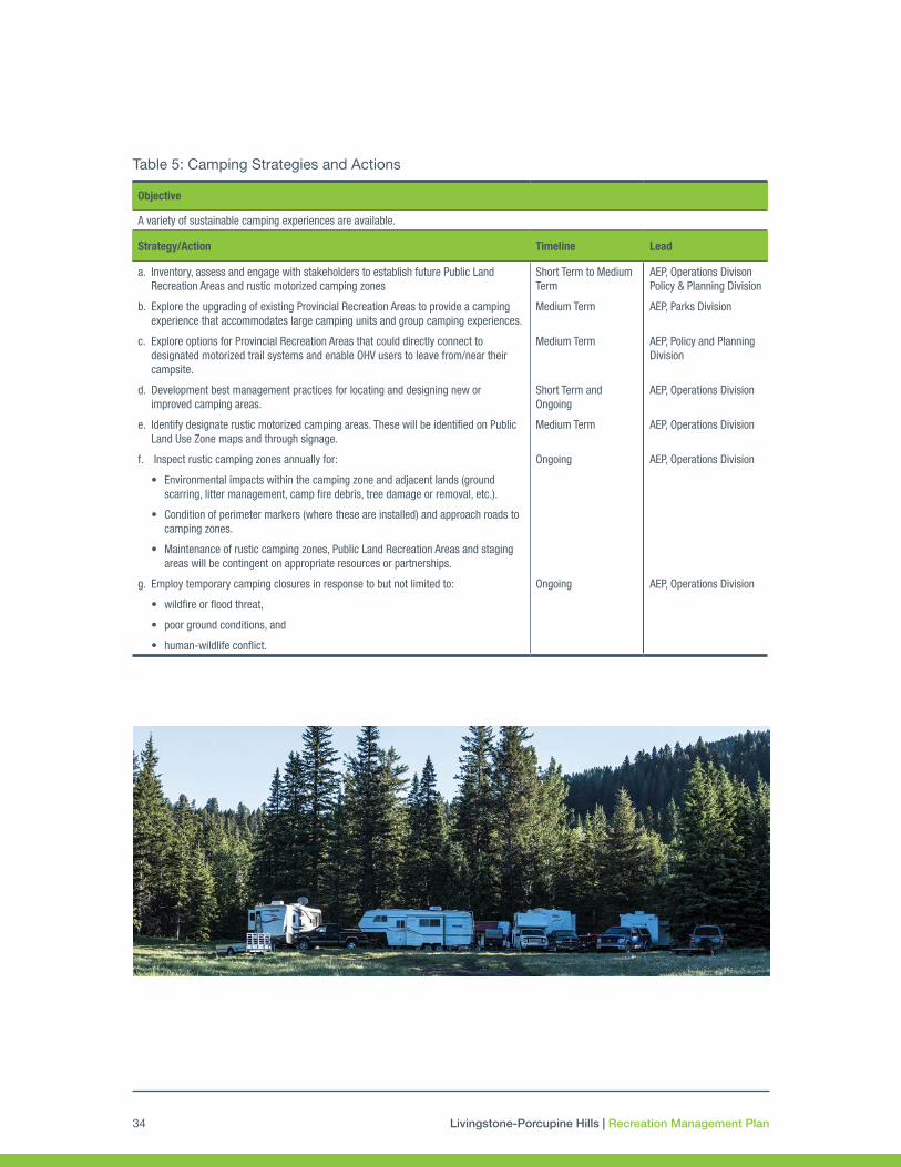
Livingstone-Porcupine Hills | Recreation Management Plan34
Objective
A variety of sustainable camping experiences are available.
Strategy/Action Timeline Lead
a. Inventory, assess and engage with stakeholders to establish future Public Land Recreation Areas and rustic motorized camping zones
b. Explore the upgrading of existing Provincial Recreation Areas to provide a camping experience that accommodates large camping units and group camping experiences.
c. Explore options for Provincial Recreation Areas that could directly connect to designated motorized trail systems and enable OHV users to leave from/near their campsite.
d. Development best management practices for locating and designing new or improved camping areas.
e. Identify designate rustic motorized camping areas. These will be identified on Public Land Use Zone maps and through signage.
f. Inspect rustic camping zones annually for:
• Environmental impacts within the camping zone and adjacent lands (ground scarring, litter management, camp fire debris, tree damage or removal, etc.).
• Condition of perimeter markers (where these are installed) and approach roads to camping zones.
• Maintenance of rustic camping zones, Public Land Recreation Areas and staging areas will be contingent on appropriate resources or partnerships.
g. Employ temporary camping closures in response to but not limited to:
• wildfire or flood threat,
• poor ground conditions, and
• human-wildlife conflict.
Short Term to Medium Term
Medium Term
Medium Term
Short Term and Ongoing
Medium Term
Ongoing
Ongoing
AEP, Operations Divison Policy & Planning Division
AEP, Parks Division
AEP, Policy and Planning Division
AEP, Operations Division
AEP, Operations Division
AEP, Operations Division
AEP, Operations Division
Table 5: Camping Strategies and Actions

Livingstone-Porcupine Hills | Recreation Management Plan 35
4.4 Nature-based Tourism, Scenic Areas and Viewpoints
Management Intent
Nature-based tourism is an important contributor to local and provincial economies, encompassing visitation that is undertaken largely or solely for the purpose of enjoying natural attractions and engaging in outdoor activities, whether for relaxation, discovery or adventure (e.g., camping, bird watching, trail riding, downhill skiing, hunting, mountain biking, motorized recreation). The South Saskatchewan Regional Plan defines the environmental priorities under which development must consider, including: headwater protection, conserving biodiversity, management of wildfire risk and integrated land management. These factors inform the location, extent and use of any nature-based tourism opportunities that may be provided. These priorities inform the location, extent and use of any nature-based tourism opportunities that may be provided. While visitation to these Public Land Use Zones should be encouraged, associated nature-based tourism and commercial recreation opportunities must fit within established thresholds for land disturbance and must also consider the resource values, desires of local communities and effects of proposed developments to the public lands outdoor recreation system.
In support of tourism within these Public Land Use Zones, the role of public lands management is to maintain, within a working landscape, the setting, important destinations, and infrastructure that facilitates a variety of positive outdoor recreation experiences. This includes commercial recreation and nature-based tourism experiences. In particular, the development of sustainable trails, staging areas, and supporting recreation infrastructure is needed to support the future growth of tourism opportunities. Recreation infrastructure, both current and future, within the Public Land Use Zones is available for use by tourism and commercial recreation operators under the same regulations and restrictions that apply to the general public. Tourism operators are not granted any preferential use of (or exclusive rights to) public recreation facilities, staging areas, trails, etc. Tourism operators can apply for authorizations for specific use for activities that are compatible with the land use in the Public Land Use Zones.
Outdoor recreation activities and nature-based tourism are major attractions for residents and non-residents. While limited commercial services are available north and south of Highway 3, visitor services and facilities are found in Municipality of Crowsnest Pass and the adjacent communities of Pincher Creek, Nanton, Longview and Claresholm. In addition to these important local communities, the designation of the Castle Provincial Park and Wildland Provincial Park creates new and unique opportunities for nature-based tourism. The Castle Region Tourism Strategy will explore support for tourism outside the recently created Castle parks. This area includes the Municipality of Crowsnest Pass and M.D. of Pincher Creek and south to the borders of the Waterton National Park. Alberta Environment and Parks staff will consider the different management intents, intended settings and requirements for supporting infrastructure when working with operators to determine the most appropriate location for their desired

Livingstone-Porcupine Hills | Recreation Management Plan36
development. Tourism operations on public lands should complement the attractions and opportunities available within the Castle parks.
Ensuring an adequate land base that maintains these high aesthetic qualities is necessary for tourism development and essential to providing certainty and security for future investment. There is a strong desire to ensure that land bases are managed for potential future commercial recreation and/or tourism use, including maintaining the features, setting, scenery, and access to recreation activities and opportunities.
Scenic Areas and Viewpoints
The Porcupine Hills and Livingstone area offers tremendous scenery. Previous plans, including the Eastern Slopes Policy (1984) recognized the high scenic and recreation values of the area that draw residents and visitors alike to visit these areas. Efforts will be made to locate trails and day use areas near viewpoints to maximize the visitor experience. However, topography, elevation, ground conditions and the presence of sensitive native vegetation are factors that ultimately determine whether viewpoints can be provided along trails. Recreation facilities will be situated in a manner that maintains scenic views.
Table 6: Nature-based Tourism, Scenic Areas and Viewpoints Strategies and Actions
4.5 Other Recreational Activities
Management Intent
Alberta’s public lands have long provided an array of recreation opportunities to Albertans and visitors including: hunting, fishing, target shooting, climbing and scrambling, kayaking and canoeing, snowshoeing, cross-country and backcountry skiing, hiking, mountain biking, caving, geo-caching, equestrian use, backpacking (i.e. backcountry camping), nature appreciation, photography, berry picking as well as other newer recreation pursuits such as zip-lining and via-ferrata. These activities are pursued by individuals and groups on their own as well as through
Objective
Tourism products and offerings that complement opportunities elsewhere in the region will be developed with local communities, First Nations, recreation user groups and tourism operators.
Strategy/Action Timeline Lead
a. Encourage surrounding communities with an interest in boosting outdoor recreation and nature-based tourism capacity to develop and implement tourism plans.
b. Investigate opportunities for identifying potential tourism development nodes in collaboration with all stakeholders, including local municipalities.
c. Identify potential commercial recreation opportunities and nature-based tourism experiences in collaboration with all stakeholders and First Nations.
Short-Medium Term
Short-Medium Term
Short Term
Culture & Tourism (C&T), Tourism Division
C&T, AEP
AEP, C&T

Livingstone-Porcupine Hills | Recreation Management Plan 37
commercial ventures and will continue in a similar way in the future. The Government of Alberta will work with stakeholders and partners to identify, build and maintain any infrastructure that might be needed to support these various recreation pursuits, including ensuring appropriate permissions or dispositions are in place.
Day Use
Specific sites within the two Public Land Use Zones have great potential for day use but are virtually undeveloped. The size and level of development offered in day use areas will vary, dependent on their location, popularity, site features and existing road access. The provision of day use opportunities would serve Albertans and visitors by providing them with:
• A scenic spot to enjoy public lands.
• Interpretive signage or kiosks that allow travelers to learn about the immediate area, the viewscape, the area’s local and natural history, dominant land uses (e.g. ranching, logging), or areas of cultural significance to First Nations. Interpretive information will be developed in collaboration with local communities and First Nations.
• The opportunity to explore and discover.
Potential sites to enable day use include, but are not limited to:
• Crowsnest Mountain (Livingstone)
• Townsite of Lille (Livingstone)
• Sharples Creek Road - East (Porcupine)
Special Events and Commercial Activities for Recreational Purposes
A special event is any organized event that requires special provisions or conditions that are not under the authority of an existing disposition. Events may range from local or family functions (e.g. wedding, family reunion) to large provincial, national and international events (e.g. rallies, international races). They may require use of public facilities or require additional amenities to be brought in (e.g. waste services, parking etc.).
Alberta Environment and Parks requires that special events for commercial purposes receive prior authorization. Commercial purpose is defined as having or intending to have an economic benefit and generally involves a fee or other reward in exchange for participation in the event. Authorizations follow established government policy and processes.
Both the Livingstone and Porcupine Hills areas are destinations for various commercial recreation and other organized special events. Events such as motorbike races, poker rallies, human endurance adventure races, and trail rides can significantly benefit the local economy and provide meaningful recreation and tourism experiences. These events may continue on

Livingstone-Porcupine Hills | Recreation Management Plan38
public land where they are compatible with the recreation management intent for the area, and with appropriate approval. Development of a standard provincial process specifically for special events on public land approvals is recommended.
Hunting and Fishing
Hunting and fishing will continue within the Livingstone and Porcupine Hills Public Land Use Zones in accordance with provincial hunting and fishing regulations. As per the Public Lands Administration Regulation, hunters and anglers will be required to stay on designated motorized trails when using motorized vehicles. The design of the designated motorized trails network will consider maintaining reasonable access to important hunting or fishing areas. According to the Public Land Administration Regulation Section 185(8), this does not apply to an individual who is exercising a right recognized and affirmed under Part II of the Constitution Act, 1982 or a right under Section 12 of the Transfer Agreement or is travelling to a location to exercise such a right.
Target Shooting
Target shooting includes the following: sport-based target shooting using firearms, trap and skeet shooting, and other types of skill based shooting done for purposes other than hunting. These activities have historically taken place on public land among areas with recreational and other activity. Subsequently, public safety has been identified as a concern. To prohibit dangerous activities such as target shooting in the Livingstone and Porcupine Hills Public Land Use Zones, Alberta Environment and Parks will post signs or notices prohibiting these activities. Further, Alberta Environment and Parks has the authority under the Public Lands Administration Regulation to prohibit dangerous activities near Public Land Recreations Areas, camping zones, designated staging and day use areas and designated trails. The safe use and discharge of a firearm can be conducted elsewhere within the Public Land Use Zones. All uses of firearms upon public land must comply with provincial and federal legislation.
Mountaineering/Rock & Ice Climbing/Via Ferrata
As public interest in mountaineering, rock and ice climbing, and via ferrata, grows in this area, the Government of Alberta will seek input from recreation users about sites and routes that may be of interest. If issues at popular climbing and scrambling sites arise, in consultation with First Nations and stakeholders, actions may be undertaken to ensure that increased use does not result in excessive impacts.
Water Access
Staging areas that provide access to larger tributaries for fisheries and water-based recreation such as canoeing, kayaking, rafting, will be designated to identify access points. This will be done in consultation with stakeholders and First Nations.

Livingstone-Porcupine Hills | Recreation Management Plan 39
Table 7: Other Recreational Activities Strategies and Actions
Objective
A diverse array of non-motorized activities, including non-trail based opportunities such as hunting, backcountry camping and hiking, mountaineering, and horseback riding are enabled.
Strategy/Action Timeline Lead
a. Working with users and commercial operators to identify and formalize water assess.
b. Ensure the designated trail system considers hunting and fishing access.
c. Explore options for designating access to popular areas for mountaineering, rock and ice climbing based on demand from the user community.
d. Identify areas where target shooting will not be permitted and include on Public Land Use Zone maps.
Short Term
Short Term
Long Term
Short Term
AEP, C&T
AEP, Operations Division
AEP, Operations Division
AEP, Operations Division
Objective
Day use opportunities are available at attractive and appropriate locations.
Strategy/Action Timeline Lead
a. Identify day use sites and upgrade if required to support intended use. Medium Term AEP, Operations Division
4.6 Education
Management Intent
Education and outreach programs will support, and align with, the management and decision-making plans for recreation and tourism experiences of the area. Educational activities are designed to support government, community, and First Nations by building collective capacity to manage the environment through enhanced awareness and understanding of sustainable recreation on public land. It is also intended to contribute to greater stewardship, protection of the environment, and enhanced recreational experiences.

Livingstone-Porcupine Hills | Recreation Management Plan40
Table 8: Education Strategies and Actions
Objective
Education and awareness of First Nations and local history, culture and values within the Public Land Use Zones are advanced.
Strategy/Action Timeline Lead
a. Reflect Indigenous history and culture in educational signage at staging areas, trail heads, viewpoints and areas of cultural significance.
b. Reflect local history of surrounding communities and current land use within the region in place names and educational signage at staging areas, trail heads and viewpoints.
c. Provide the public with information on First Nations’ treaty rights and traditional land use practices as it applies to access on public land.
Short-Medium Term
Short-Medium Term
Short-Medium Term
AEP, C&T
AEP, C&T
AEP, C&T
Objective
Public awareness of the designation of the Porcupine Hills and Livingstone areas as Public Land Use Zones and of the associated rules and regulations is increased.
Strategy/Action Timeline Lead
a. Provide information on best practices for recreation activities and recreating in a safe manner through social media campaigns, the Alberta Environment and Parks website, public service announcements, and utilize existing Government of Alberta educational campaigns for responsible recreation.
b. Develop integrated programming to equip enforcement, engagement and other staff with information and materials to engage and educate visitors on-site.
c. Plan and host ‘Respect the Land’ trailer events, education workshops, presentations and support stewardship events led by partners.
d. Create a smart phone app to accompany the Alberta Environment and Parks website to share information on the rules and regulations associated with the two Public Land Use Zones including communicating area closures.
Short Term
Short-Medium Term
Short Term
Short-Medium Term
AEP, Fish & Wildlife Enforcement Branch (FWEB)
AEP, FWEB, Strategy Division
AEP, Strategy Division
AEP
Objective
Public understanding of the recreational opportunities available, responsible use of the natural environment and stewardship practices is enhanced.
Strategy/Action Timeline Lead
a. Develop materials and messaging to be distributed and delivered by multiple partners, as well as by the Government of Alberta.
b. Establish and foster mutually beneficial partnerships that expand the delivery of land stewardship and responsible recreation education. Identify, manage and promote opportunities for partners to participate in planned recreational and environmental stewardship activities and events.
c. Develop interpretative signage at staging areas, trail heads and viewpoints to highlight the natural environment.
d. Support development of self-guiding/interpretive brochures/maps for specific trails that provide information on natural and cultural values.
Short Term
Ongoing
Short-Medium Term
Medium-Long Term
AEP, Strategy Division
AEP, Operations Division
AEP, Operations Division, Strategy Division
Partners, AEP, Strategy Division

Livingstone-Porcupine Hills | Recreation Management Plan 41
4.7 Compliance and Public Safety
Management Intent
Compliance
The authority for managing recreation activities on public land is mainly derived from the Public Lands Act and Public Land Administration Regulation. The Public Land Use Zone provides authority to enforce rules and regulations, including specific direction from a notice of an officer. All recreational users in the Livingstone and Porcupine Hills must comply with any conditions and restrictions that are identified and should report public lands infractions through existing programs (e.g. Report a Poacher program).
The Public Land Administration Regulation provides a list of actions and activities that are illegal, as does the Traffic Safety Act, the Off-highway Vehicle Regulation, and the Forest and Prairie Protection Act. Infractions that may be ticketed at the time of the offence are outlined in the Provincial Offences Procedures Act while other offences require a court summons. As new provincial enforcement guidelines, tools and instruments are approved; those pertaining to recreation regulations will be adopted. Enforcement responsibilities will be led by the Government of Alberta and include collaboration with other enforcement agencies. Where education and enforcement are not effective and consistent non-compliant behaviour persists, additional measures may be taken including temporary or permanent closures of areas for specific uses.
Public Safety
The recreation system will be designed, constructed, and maintained to provincial standards and guidelines. Education, enforcement and stewardship partnerships will be utilized to inform and encourage safe and responsible behaviours. However, it is important that users recognize these are wilderness areas, with little to no immediate emergency response available. Visitors to the area should be aware of the risks and have the appropriate skill level and equipment to undertake their chosen activity.
Recreation use is an important piece of emergency response planning. This type of planning clarifies the roles and responsibilities of the various agencies and governments that provide or support emergency responses. They must consider the full range of potential situations or hazards that may occur, not just recreation. Emergency response plans for the Public Land Use Zones, when prepared, will however ensure that potential recreation related emergency responses are considered.
The Wildfire Management Branch of Alberta Agriculture and Forestry implements various measures under the Forest and Prairie Protection Act to manage wildfire risk and safety. These measures include fire restrictions and fire bans, OHV bans, and in extreme fire hazard situations, forest reserve closures. Public lands may be closed due to other risks including flooding, storms, and human-wildlife conflicts. Any closures will be communicated broadly.

Livingstone-Porcupine Hills | Recreation Management Plan42
Objective
Public safety messaging, including education about the risks inherent in outdoor recreation activities on public lands, is delivered by Alberta, Environment and Parks and other partners
Strategy/Action Timeline Lead
a. Use signs and other media to communicate safety messages to recreational users.
b. Inform Albertans and visitors about the risks of recreating on public lands through education and outreach programs.
Ongoing
Short Term and Ongoing
AEP, Operations Division, Strategy Division
AEP, Strategy Division
Table 9: Compliance and Public Safety Strategies and Actions
Objective
Those involved in compliance activities (e.g. enforcement officials, education staff, partner groups) are engaged to provide ongoing and continued enforcement, education, awareness and outreach to support acceptable behaviour on public lands.
Strategy/Action Timeline Lead
a. Implement temporary closure of trails and areas, or restriction of certain activities to reduce wildfire risk, flood risk, wildlife-human conflict risk or other public safety matters.
b. Impose speed limits on designated OHV trails within Public Land Recreation Areas where warranted.
c. Make Indigenous cultural awareness training available to all provincial officers on public lands.
d. Implement provincial enforcement actions and priorities throughout the Public Land Use Zones (e.g. long weekend compliance campaigns, regulatory messaging.).
e. Compliance, engagement and other staff will engage with visitors on-site to provide information and/or materials.
Ongoing
Short Term
Short Term
Ongoing
Ongoing
AEP, Operations Division
AEP, Operations Division
AEP, Parks Division
GoA, Public Lands Enforcement Committee (PLEC)
AEP, Operations Division, Strategy Division
4.8 Partnerships
Management Intent
The success of recreation management in the two Public Land Use Zones will be dependent on partnerships. Recreation groups engaged in the development, management and/or stewardship of the recreation system often take significant pride in their investments, align themselves with best management practices for managing trail systems, and are responsible users (with the expectation that others will also demonstrate responsible behaviours). Local recreation groups and clubs have proven themselves to be positive partners with the Government of Alberta in the construction and maintenance of trail networks in the Livingstone and Porcupine Hills areas, investing significant time and resources. Other groups have focused on environmental stewardship including: reclamation and restoration projects for riparian areas and old trails, delivering education and outreach programming and messaging to support responsible and sustainable use of public lands, and monitoring to assist in evaluating the recreation system.

Livingstone-Porcupine Hills | Recreation Management Plan 43
Objective
Partnerships with recreational groups are encouraged and recreation users have the opportunity to participate in stewardship activities such as clean-up days, restoration, trail maintenance and monitoring.
Strategy/Action Timeline Lead
a. The Government of Alberta will establish multi-sector advisory group(s) to support the implementation of the Recreation Management Plan.
b. Stakeholder support and partnerships will be pursued to establish, maintain and monitor recreation infrastructure, education and outreach, and reclamation activities.
Short Term
Ongoing
AEP, Operations Division
AEP, Operations Division
Table 10: Partnerships Strategies and Actions
The Government of Alberta will continue to coordinate partnerships with volunteers and willing parties including: clubs, associations, stewardship groups, municipalities, First Nations, willing individuals, industry, disposition holders, landowners and interested organizations.
It is recognized that there is uncertainty around liability of trails and recreation infrastructure when either developed or maintained by trail groups and not-for-profit organizations. Improved processes for agreements with organizations will be pursued to clarify liability and role in risk management between the Government of Alberta and parties active in recreation infrastructure development and/or maintenance or stewardship activities on these public lands. It is also recommended that provincial policy be developed that provides clarity and certainty on the assumption of risk between the Government of Alberta, recreation users and the parties supporting recreation management.
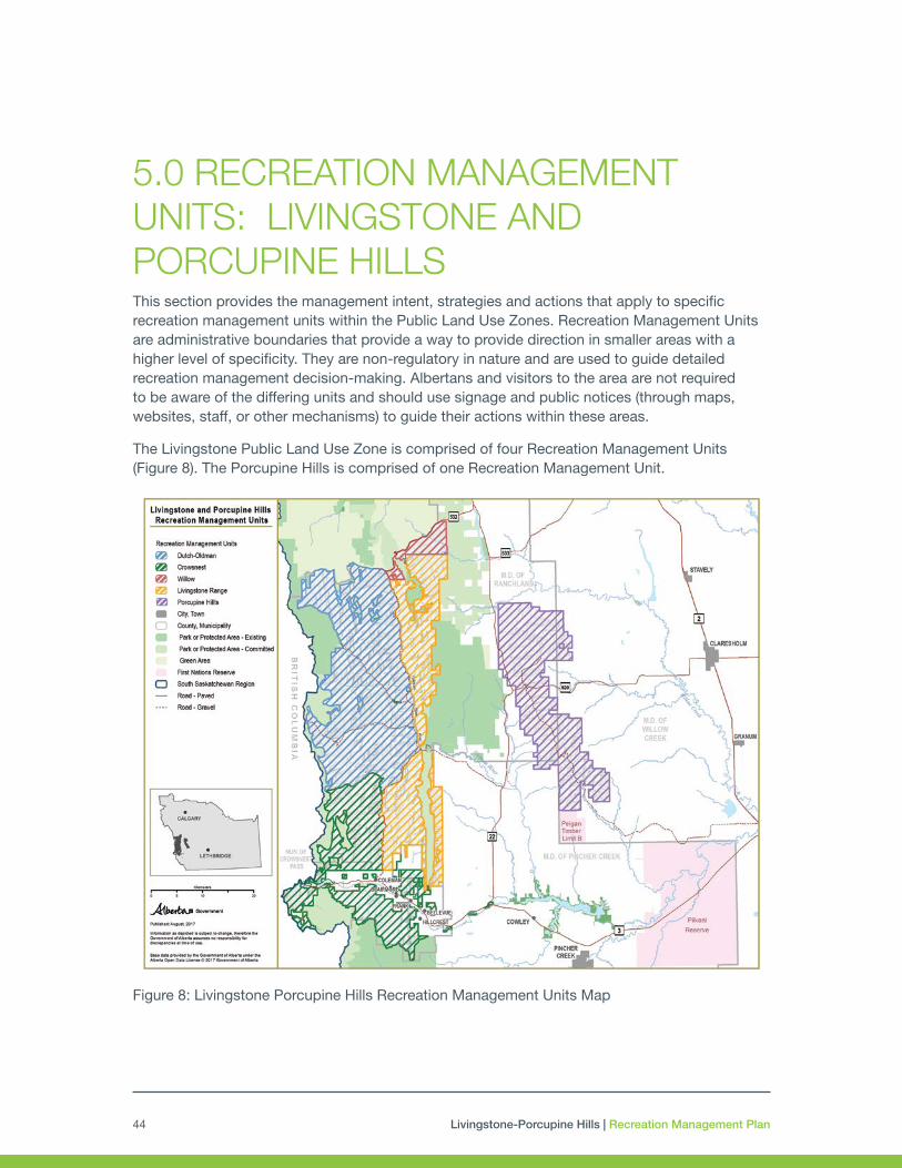
Livingstone-Porcupine Hills | Recreation Management Plan44
5.0 RECREATION MANAGEMENT UNITS: LIVINGSTONE AND PORCUPINE HILLS This section provides the management intent, strategies and actions that apply to specific recreation management units within the Public Land Use Zones. Recreation Management Units are administrative boundaries that provide a way to provide direction in smaller areas with a higher level of specificity. They are non-regulatory in nature and are used to guide detailed recreation management decision-making. Albertans and visitors to the area are not required to be aware of the differing units and should use signage and public notices (through maps, websites, staff, or other mechanisms) to guide their actions within these areas.
The Livingstone Public Land Use Zone is comprised of four Recreation Management Units (Figure 8). The Porcupine Hills is comprised of one Recreation Management Unit.
Figure 8: Livingstone Porcupine Hills Recreation Management Units Map

Livingstone-Porcupine Hills | Recreation Management Plan 45
Recreation Management Unit Summary
Each Recreation Management Unit is comprised of different values, management intent, desired settings and compatible activities. Table 11 summarizes the overall management direction of these areas. More detail can be found in Sections 5.1 and 5.2.
The recreation setting is representative of the spectrum of recreation opportunities possible within a given landscape based on the experience sought. While the affects of industry may change the overall setting of a specific location over time, generally, recreation in the Recreation Management Units will be managed to the following settings:
• Backcountry: Very low levels of infrastructure, largely natural surroundings (some industry or agriculture activity may be evident but only in isolated locations), no, or limited, services or amenities, expectation of fewer recreationists within the area
• Mid-Country: Some infrastructure developed; a variety of natural and modified surroundings; some services or amenities may be provided at high use locations; may encounter other recreationists
• Front-Country: Infrastructure developed to support high intensity use; surroundings may be modified or highly modified (e.g. roads, industrial uses, human settlement); some amenities or services are provided; likely to encounter other recreationists
Table 11: Recreation Setting and Activities by Recreation Management Unit
* Provision will be made for dedicated, engineered mountain biking trails in the Crowsnest RMU ^ Summer motorized activity will avoid the Continental Divide and proposed wildland parks, which will be focused on backcountry and non-motorized activities with the exception of designated trails that cross in to British Columbia. Long term management of the proposed wildland parks will be done as part of the Parks planning process. Note 1: Other recreational activities not listed in the matrix (i.e. hunting, fishing, climbing, scrambling, backcountry skiing, backcountry backpacking/camping, caving, geo-caching, nature appreciation, photography, canoeing, kayaking, tubing, picnicking, etc.) are permissible within a Recreation Management Unit unless restricted by applicable regulations, guidelines or conditions. Access for First Nations exercising treaty rights and traditional land uses and range allotment holders will be maintained in all Recreation Management Units.
Crowsnest RMU
Livingstone Range RMU
Oldman Dutch RMU
Willow Creek RMU
Porcupine Hills RMU
Recreation Setting Front-Country to Mid-Country
Backcountry Mid-Country to Backcountry
Mid-Country Mid-Country to Backcountry
Summer Motorized Trails e.g. quads, side by sides, dirt bikes, trucks, 4x4
Yes Limited Yes^ Yes Yes
Winter Motorized Trails Yes No Yes Yes No
Summer Non-Motorized Activities hiking, equestrian, mountain biking.
Yes* Yes Yes Yes Yes
Winter Non-Motorized Activities e.g. snowshoeing, skiing
Yes Yes Yes Yes Yes
Motorized Special Events Yes No Yes Yes Limited (no more than 2 per year)
Non-motorized and Other Special Eventse.g. endurance races, festivals
Yes No Yes Yes Yes
Backcountry Camping Yes Yes Yes Yes Yes
Rustic Motorized Camping(in designated areas)
Yes Limited Yes Yes Yes

Livingstone-Porcupine Hills | Recreation Management Plan46
5.1 Livingstone Recreation Management Units
Background
As shown in Figure 8, the Livingstone Public Land Use Zone occupies a large land base along the continental divide. It has experienced considerable recreational use in the past, which has grown stronger with each passing decade. The area is particularly popular among hunters, anglers, random campers and OHV enthusiasts (both summer trail riders and winter snowmobile users). Recreational access to every mountain valley is available due to established public and industry roads.
Snowmobiling, and use of other tracked vehicles, has grown substantially within the Livingstone Public Land Use Zone over the last 30 years, with Crowsnest Pass area being frequently voted one of the best riding areas in western Canada. For snowmobilers, the area provides:
• high snowfall
• long riding season
• variety of terrain on groomed and ungroomed trails
• convenient staging areas
• impressive scenery
• proximity to amenities and services needed by riders
In addition to the recreational values, the Livingstone Public Land Use Zone provides important habitat for key land and water-based species, including species at risk (e.g. westslope cutthroat trout, grizzly bear). The Public Land Use Zone is also an active working landscape with logging, oil and gas development, mining, and trapping underway. Grazing is another significant land use, with ranching being a primary income source for a large number of residents.
First Nations have a special connection to the Livingstone area. Several significant sites within the Livingstone are reflected in oral history, with First Nations exercising treaty rights, traditional land uses and cultural practices into present day. Management of recreation within Livingstone will respect the historical and cultural significance of the area and ongoing conversations with First Nations will help to ensure that effects to the Nations from public use are understood and mitigated appropriately.
Additionally, the Livingstone Public Land Use Zone is envisioned as capable of supporting year round commercial recreation and tourism opportunities of all types. Crowsnest Pass is an important hub and gateway for recreational activity on surrounding public lands. Growth of tourism and outdoor recreation related industries are desired by the community, and the surrounding public lands will play a pivotal role in providing the features, scenery, and setting, including the recreation infrastructure, that attracts visitors to the area.
Livingstone-Porcupine Hills | Recreation Management Plan 47
The potential of the Livingstone Public Land Use Zone as a destination for winter recreation and supporting non-motorized commercial recreation, such as hiking and trail riding, has been recognized and should be encouraged, along with continued motorized recreation during the summer.
Services for visitors within the Public Land Use Zone are very limited and servicing for infrastructure development (power, water, sewage), are not readily available. The focus of enhancements and new nature-based tourism development will be focused within the Crowsnest Recreation Management Unit that surrounds the municipality. As such, partnerships for recreational trail development, road sharing and other services that will enable tourism growth within the municipality are critical. Similarly, coordination with Alberta Transportation is necessary to ensure that future road upgrades, signage and pull-out areas support access to the Livingstone recreation system.
Recreation Opportunity Concept Maps
Figures 8 – 10 outline the intent to enhance the management of outdoor recreation in the planning area and are a representative of the current understanding of the desired future state at the time of plan approval. They should be referred to as information maps only representing concepts and strategic direction and are a summarized visual representation of the management intent and specific direction laid out within Sections 5.1 and 5.3. These maps are not regulatory nor legally binding in nature and the current year Public Land Use Zone Map (Section 5.4) must be consulted for designated trails and areas.

Livingstone-Porcupine Hills | Recreation Management Plan48
Figure 9: Livingstone Summer Recreation Opportunity Map - Motorized

Livingstone-Porcupine Hills | Recreation Management Plan 49
Figure 10: Livingstone Summer Recreation Opportunity Map – Non-Motorized

Livingstone-Porcupine Hills | Recreation Management Plan50
Figure 11: Livingstone Winter Recreation Opportunity Map
Livingstone-Porcupine Hills | Recreation Management Plan 51
5.1.1 Crowsnest Recreation Management Unit
Management Intent
The Crowsnest Recreation Management Unit has historically experienced heavy recreational use and will continue to provide a full range of four-season recreation activities and tourism experiences in the future. A significant feature of the Recreation Management Unit is that it includes the interface with the Municipality of Crowsnest Pass. Recreation users will have access to a range of amenities and services (many of which are pre-existing and located within the municipality) and, in the future, to a well-developed recreation infrastructure system on public land in the surrounding areas. Inter-connected trail systems will expand visitor experiences and connect communities, scenic or cultural sites, and tourism features. Natural, local, Indigenous, and other cultural and historical interpretation opportunities will be promoted. More specifically, the following will be pursued:
• Provide an assortment of four-season recreation opportunities in close proximity to the Highway 3 corridor and the Municipality of Crowsnest Pass.
• Concentrate recreation infrastructure and amenities within this Recreation Management Unit and design recreation facilities to withstand high intensities of use.
• Enable the development of appropriate nature-based tourism opportunities.
• Accommodate both motorized and non-motorized recreation activities through winter and summer while ensuring enough separation between conflicting uses.
• Formalize hiking trails to well-known destinations and features.
• Provide continued support for winter cross-country ski trail systems managed by partners.
• Provide a large variety of options for day trips and excursions.
• Provide recreation experiences for all ages and abilities.
• Enable opportunities for unique recreation activities (e.g., OHV obstacle and skill-testing area for new and experienced riders, adventure races) where appropriate.
Given the significant potential for expanded recreation opportunities, the Government of Alberta will work with the Municipality of Crowsnest Pass to explore developing an interconnected recreation infrastructure system that promotes economic diversification, environmental sustainability, and improves quality of life and experiences for residents and visitors. Several locations within this Recreation Management Unit are unsuitable for recreation development due to wildlife habitat sensitivities and will be avoided.

Livingstone-Porcupine Hills | Recreation Management Plan52
Connectivity
The Crowsnest Recreation Management Unit presents a unique opportunity in providing the setting for connected and diverse trails systems for both summer and winter use. This area contains four main staging and/or camping sites –including Atlas, McGillivray, Sartoris and York Creek. The Recreation Management Unit also contains numerous trail connections from the local municipalities into the Public Land Use Zone, desirable connections to the Castle Parks for winter and non-motorized trails, connections north into the adjacent Dutch-Oldman Recreation Management Unit, as well as trail connections to British Columbia. It also contains portions of the most significant hiking trail in the region – the Great Divide Trail. The Government of Alberta will encourage trail development that connects trail networks within the region.
5.1.2 Livingstone Range Recreation Management Unit
Management Intent
The area has high scenic values and draws a variety of non-motorized users including hikers, equestrian users, hunters and anglers. Water-based recreation along the Livingstone and Oldman Rivers is also popular. Given the area’s natural landscape and habitat values, the focus of this Recreation Management Unit will be on non-motorized backcountry recreation experiences. As fishing and hunting are popular in this area, provision will be made for a limited number of designated motorized trails to support these activities.
Few recreation facilities are anticipated within the area in the immediate future. Existing roads and staging areas will remain in place. If recreational demand and use grows in future years, an assessment on the need for staging areas and formalized non-motorized trails will be undertaken. Similarly, no formalized connectivity with the Bob Creek Wildland Provincial Park is currently envisioned. Non-motorized connections may be explored in the future. A limited number of rustic camping zones may be considered in the future to support non-motorized activities.
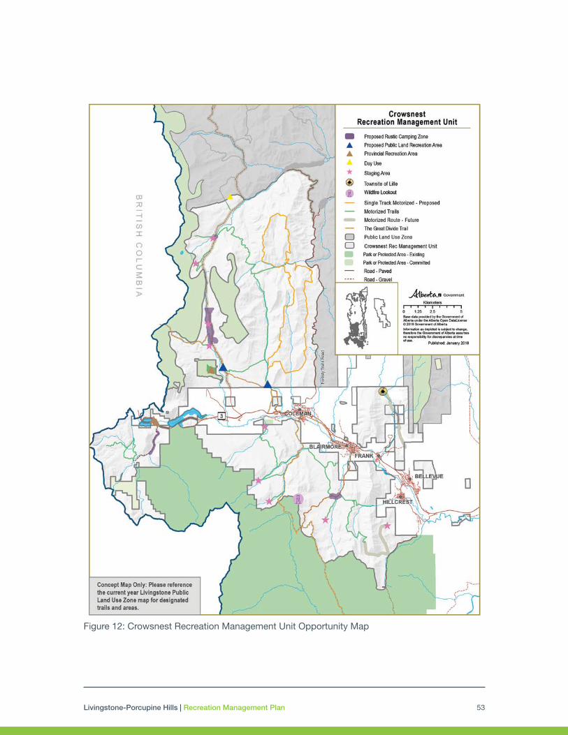
Livingstone-Porcupine Hills | Recreation Management Plan 53
Figure 12: Crowsnest Recreation Management Unit Opportunity Map

Livingstone-Porcupine Hills | Recreation Management Plan54
Figure 13: Livingstone Range Recreation Management Unit Opportunity Map

Livingstone-Porcupine Hills | Recreation Management Plan 55
5.1.3 Dutch-Oldman Recreation Management Unit
Management Intent
This Dutch-Oldman Recreation Management Unit is comprised of several watershed basins: Racehorse Creek, Dutch Creek, Hidden Creek, Upper Oldman River and other minor drainages. The overall management intent is to provide opportunities for rustic motorized camping and motorized recreation at designated locations and on designated trails (winter and summer) supported by necessary staging areas. Non-motorized forms of recreation can occur throughout the entirety of this Recreation Management Unit. Appropriate and compatible forms of nature-based tourism (e.g. guiding, outfitting) that utilize existing infrastructure could be accommodated. Staging areas for equestrian and hiking use will be provided, focused near the Beehive Natural Area.
The area offers important opportunities for motorized recreation that support a variety of skill levels for riders. As trails are upgraded to promote sustainability, providing a varying level of technical challenge within trail systems will be incorporated into detailed trail design. A limited amount of highly technical motorbike or single track trails may be designated. These single track trails will be situated on suitable terrain and with appropriate timing restrictions. Within the Hidden Creek drainage, recreation infrastructure will be reduced to address known resource concerns, including westslope cutthroat trout. No summer motorized trails will be designated in close proximity to Hidden Creek.
Improved opportunities for summer and winter OHV use and rustic motorized camping will be provided in the lower Racehorse, Dutch Creek, the Upper Oldman and remaining minor drainages. The focus of this activity will be in the central portion of the Recreation Management Unit with limited trails that connect to BC or allow for effective connectivity of the network along the western portion of the area. Motorized access will be routed away from the Crown of the Continent area unless providing connectivity to neighboring trail systems.
The west side of the Recreation Management Unit is important for snowmobilers, providing some of the highest quality snowmobile areas in the province, as well as connectivity to well-known snow areas in BC. Random ride areas and routes for snowmobilers have been identified. (Figure 13: Livingstone Winter Motorized Trails and Areas).
During summer use, the western portion immediately adjacent to the proposed High Rock Wildland Park will be focused towards non-motorized uses including backcountry hiking, hunting, fishing etc. Limited summer motorized trails will be included on the western portion to allow for staging areas for non-motorized activities.

Livingstone-Porcupine Hills | Recreation Management Plan56
Figure 14: Dutch–Oldman Recreation Management Unit Opportunity Map

Livingstone-Porcupine Hills | Recreation Management Plan 57
5.1.4 Willow Creek Recreation Management Unit
Management Intent
The Willow Creek Recreation Management Unit is a popular day use and camping area supporting a variety of recreation opportunities. Within a half-day’s driving distance from Calgary and communities to the south, the area provides year-round opportunities, including rustic motorized camping at designated camping zones. The area will allow continuation of motorized recreation using the designated trails.
Existing equestrian use will be supported by upgrading staging areas with specific amenities required for riders to access the surrounding land base. There is significant opportunity for enhanced hiking trails that lead around and into the Mount Livingstone Natural Area and Bob Creek Wildland Provincial Park, with staging and access originating within the Willow Recreation Management Unit. The potential for development of these trails will be explored with partners.
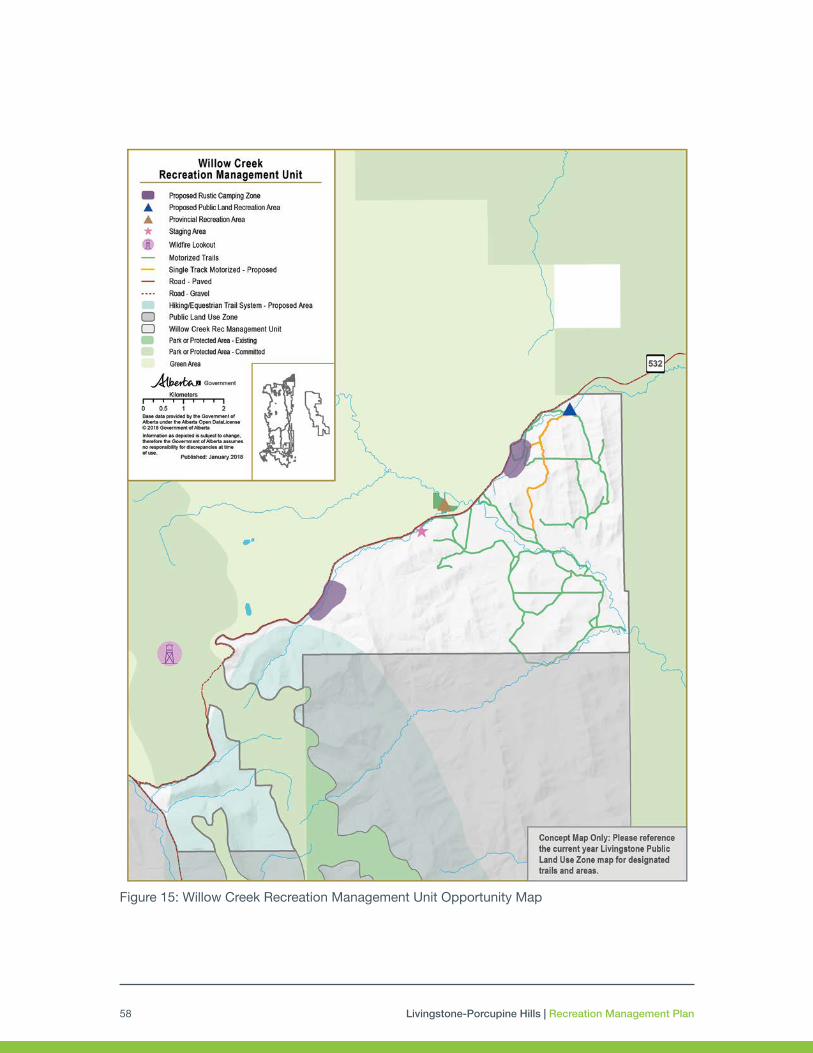
Livingstone-Porcupine Hills | Recreation Management Plan58
Figure 15: Willow Creek Recreation Management Unit Opportunity Map

Livingstone-Porcupine Hills | Recreation Management Plan 59
5.2 Porcupine Hills Recreation Management Unit
Background
Porcupine Hills provides a unique combination of vistas, varied topography and vegetation that makes the area attractive for a number of recreational activities. The southern areas are easily accessible from nearby Lethbridge, and major highways including Highway 22 and Highway 520 provide excellent transportation to the Public Land Use Zone. While most activity happens in the summer season due to unreliable and early melting snowpack, the area is enjoyed year round for day use and overnight activities. Hunting is a significant activity within the area. Scenic gravel roads also currently exist, including Skyline Road, Beaver Creek Road, and East and West Trout Creek Roads.
Portions of the Porcupine Hills have experienced heavy recreational use such as random camping and motorbiking. These activities have had a significant affect on the lands and require enhanced management including improved trail location design, reduction in motorized access as per the Land Footprint Management Plan, and compliance in order to remain sustainable for the long term. The Public Land Use Zone is surrounded by private landowners and is also used extensively for logging and ranching. Given the close proximity of private landowners around these public lands, there is a need to respect private property along the boundaries of the Public Land Use Zone. The area also contains a high amount of fescue grassland and springs, as well as provides important wildlife habitat for ungulates (mountain sheep, elk, deer, moose, etc.).
The Porcupine Hills are an important area for First Nations. The area is currently used by First Nations for exercising Treaty Rights, gathering of medicinal plants and other resources as well as containing sites of cultural or historical significance. Respect for First Nations traditional land use will be integrated in management decisions and ongoing conversations with area First Nations will help ensure that potential affects from the designated recreation infrastructure system are mitigated.
Management Intent
The overall management intent for the recreation system in the Porcupine Hills is to provide opportunities that take advantage of the high scenic values and interesting and unique terrain for formalized and dispersed non-motorized trails, day use as well as camping. The focus will be on providing a rustic and natural visitor experience, without significant modifications to the landscape. A designated motorized recreation trail system will provide experiences for OHV users, focusing on families, casual riders and shorter distance rides. Similarly, rustic motorized camping will be within designated zones and Public Land Recreation Areas.
North of Highway 520 in the Porcupine Hills, minimal motorized access (with appropriate staging) will be maintained to provide access for different types of recreation including hunting, day use, hiking and other dispersed recreation. The area south of Highway 520 will have a trail

Livingstone-Porcupine Hills | Recreation Management Plan60
network designated for higher density motorized use. The designated trail system will make use of existing trails where environmentally feasible to limit development of new infrastructure on undisturbed land, especially avoiding disturbance on native grasslands. Within the southernmost portions of the Porcupine Hills (Figure 18: Porcupine Hills Recreation Opportunity Map), a non-motorized zone is delineated. This zone prohibits designated recreational motorized access. Formalized trails may be established in the future for hiking and equestrian use. Staging areas that support access for non-motorized use will be established in the area near Beaver Creek.
Winter Motorized Trails
Porcupine Hills rarely has enough snowpack to permit the establishment of winter motorized trails. Should the snowpack be adequate, recreationists may use the designated summer trails in the Porcupine Hills for snowmobiling. Within the Porcupine Hills, snow and/or ice bridges are not feasible and existing bridges must be used.
Nature-based Tourism, Viewpoints and Scenic Features
Existing developed tourism opportunities are limited within the Porcupine Hills; however, the surrounding area currently promotes ranching heritage through commercial trail riding, working ranch vacations, and B & B lodging which celebrate the cowboy culture. These ventures are encouraged to continue to use the Porcupine Hills trails and staging areas to support their businesses. Additionally, opportunities may exist for Indigenous tourism. Tourism operations that align with the Recreation Management Plan, Land Footprint Management Plan, and South Saskatchewan Regional Plan will be encouraged to locate their activities to this area.
Special Events and Commercial Activities for Recreational Purposes
A variety of special events have occurred in this area in the past, including car rallies, motorbike events, and dog trials. Future applications for commercial special events must demonstrate alignment with this Plan, including assessing and mitigating for potential impacts to biodiversity, wildfire risk, and other land uses in the area. A maximum of two commercial special events per year may be permitted off the designated trail network in Porcupine Hills, including within the non-motorized zone. Approval may be subject to conditions such as timing restrictions, requirements for reclamation, approval of racecourse, and other conditions that the approval authority may deem necessary. Considerations for adjacent landowners will be required for all events.
Recreation Opportunity Concept Maps
Figure 15 indicates the strategic intent of enhancing the management of outdoor recreation in the planning area and are a representative of the current understanding of the desired future state at the time of plan approval. They should be referred to as information maps only representing concepts and strategic direction and are a summarized visual representation of the management intent and specific direction laid out within Sections 5.1 and 5.3. These maps are not regulatory nor legally binding in nature and the current year Public Land Use Zone Map (Section 5.4) must be consulted when recreating within the Public Land Use Zones.

Livingstone-Porcupine Hills | Recreation Management Plan 61
Figure 16: Porcupine Hills Recreation Opportunity Map

Livingstone-Porcupine Hills | Recreation Management Plan62
5.3 Recreation Management Unit Strategies and Actions
In addition to the overarching strategies and actions identified in Section 4, the following area-specific strategies and actions have been identified by stakeholders and Government of Alberta staff as important to enhancing or maintaining the outdoor recreation system into the future. These actions will be pursued subject to availability of partnerships and prioritization of resources.
Table 12: Recreation Management Unit Specific Strategies and Actions
Crowsnest Recreation Management Unit
Strategy/Action Timeline Lead
Trails and Staging Motorized
Establish a single track motorcycle area along the Forestry Trunk Road as shown in Figure 12. This network will be established in an area that is sustainable for heavy use and built in collaboration with users.
Develop and maintain a snowmobile trail connection between the Cataract Creek Public Land Use Zone and the Atlas area within the Livingstone as well as into the Crowsnest Pass.
Winter random riding areas will be identified for snowmobile use. Proposed areas include, but not limited to, Dean’s Peak and Window Mountain.
Development of family-oriented OHV riding areas around McGillivray Creek and Atlas areas to support youth, family, and new riders.
Maintain access to Tent Mountain
Short Term
Short Term and Ongoing
Short Term and Ongoing
Medium Term
Short Term
AEP, Operations Division
AEP, Operations Division and Snowmobile Groups
AEP, Operations Division
AEP, Operations Division
AEP, Operations Division
Trails and Staging Non-motorized
Identify non-motorized trail networks that connect the region’s parks and protected areas with the Livingstone Public Land Use Zone.
• Consider viability and desirability of enabling public access to the Ptolemy Caves.
• Maintain non-motorized access through Castle Park to the North York Creek plane crash site within Castle Provincial Park.
Designate the Great Divide Trail, Crowsnest Mountain, Window Mountain Lake and other trails in the area.
Designate popular summer hiking trails around the Crowsnest Pass to encourage wider use.
Explore options to develop and designate enhanced cross-country skiing, snowshoeing, skijoring or ski touring trails around the Crowsnest Pass; in particular, in and around the Alison/Chinook area.
Enable mountain bike clubs and other interested parties to develop and upgrade mountain bike trails in the Crowsnest Pass and other appropriate areas.
Short-Medium Term
Short-Medium Term
Short-Medium Term
Short-Medium Term
Ongoing
AEP, Operations Division and Parks Division
AEP Operations Division, Trail Groups
AEP, Operations Division
AEP, Operations Division, Trail Groups
Interested clubs and organizaitons

Livingstone-Porcupine Hills | Recreation Management Plan 63
Trails and Staging Strategy/Action Timeline Lead
Camping Explore option to establish Public Land Recreation Areas for enhanced management of high use camping and staging areas. For Crowsnest Recreation Management Unit, these may include Atlas and McGillivray Creek.
Short Term AEP, Policy and Planning Division
Dutch - Oldman Recreation Management Unit
Strategy/Action Timeline Lead
Trails and Staging Motorized
Explore placement with local user groups and Alberta Parks of a winter safety shelter between Racehorse Creek and Cataract Creek (to the north) along the designated snowmobile network within the Public Land Use Zone or within Honeymoon Provincial Recreation Area.
Maintain the existing Racehorse Creek Safety Shelter for snowmobilers use in partnership with the local clubs.
Develop and maintain a snowmobile trail connection between the Cataract Creek Public Land Use Zone and the Atlas area within the Livingstone.
Short-Medium Term
Ongoing
Ongoing
AEP Operations Division and/or Parks Division
Snowmobile Groups
AEP, Operations Division and Snowmobile Groups
Trails and Staging Non-motorized
Maintain non-motorized access to Window Mountain within the proposed High Rock Wildland Provincial Park including appropriate staging.
Formalize the Great Divide Trail to secure the route long term.
Upgrade staging and trails into the Beehive Natural Area for equestrian and hiking use.
Identify non-motorized trail networks that connect regional Parks and Protected Areas (i.e. Kananaskis Country), and with British Columbia.
Short Term
Short Term
Medium Term
Medium-Long Term
AEP, Operations Division. Parks Division
AEP, Operations Division
AEP, Operations Division
AEP, Operations Division
Camping Explore option to establish Public Land Recreation Areas for enhanced management of high use camping and staging areas. For Dutch-Oldman Recreation Management Unit, these may include Caesar’s Flats.
Short Term AEP, Policy and Planning Division
Livingstone Range
Strategy/Action Timeline Lead
Trails and Staging Motorized
Determine feasibility of upgrading motorized access along Daisy Creek to address environmental concerns, including trail rerouting, trail upgrading and bridge placement prior to permitting motorized access.
Short-Medium Term AEP, Operations Division
Trails and Staging Non-motorized
Designate non-motorized trails for access to the Livingstone Range and develop staging areas where appropriate.
Medium-Long Term Trail Groups
Other Recreation Activities
Monitor existing water recreation put in/take out sites; upgrade or close as required to maintain environmental values and promote positive experiences.
Long Term AEP, Operations Partners

Livingstone-Porcupine Hills | Recreation Management Plan64
Willow Creek
Strategy/Action Timeline Lead
Trails and Staging Non-motorized
Explore options for formalization and expansion of hiking and mountain biking trails into nearby areas.
As resources permit, upgrade existing staging areas in the Recreation Management Unit to support equestrian use. Enhanced amenities may include hitching rails, corral structures, etc.
Maintain access from Willow Creek to public lands and parks and protected areas to the north and south for hiking and equestrian use.
Medium Term
Medium Term
Short Term
AEP, Operations Division
AEP, Operations Division
AEP, Operations Division
Camping Explore option to establish Public Land Recreation Areas for enhanced management of high use camping and staging areas. For the Willow Creek Recreation Management Unit, these may include the area known as Stimson Creek.
Short Term AEP, Policy and Planning Division
Porcupine Hills
Strategy/Action Timeline Lead
Trails and Staging Motorized
Establish a motorized loop in the North Porcupine Hills to allow for hunting access, non-motorized staging and dispersed recreation.
Establish a limited designated summer OHV trail system focused on shorter rides.
Short Term
Short Term
AEP, Operations Division
AEP, Operations Division
Trails and Staging Non-motorized
Maintain recreational access to the Porcupine Hills as a destination for individuals, families and visitors for low intensity recreation use.
Look for opportunities for developing hiking, equestrian and mountain bike trails in the north Porcupine Hills, that are connected to the proposed staging and camping areas (e.g. the trail informally known as the ‘north ridge walk’).
Ongoing
Medium Term
AEP, Operations Division
AEP, Operations Division
Camping Explore option to establish Public Land Recreation Areas for enhanced management of high use camping and staging areas. For the Porcupine Hills Recreation Management Unit, these may include the Beaver Creek and Trout Creek.
Short Term AEP, Policy and Planning Division
Livingstone-Porcupine Hills | Recreation Management Plan 65
5.4 Public Land Use Zone Maps
Maps will be prepared that provide important information for recreational users within the Livingstone and Porcupine Hills Public Land Use Zones. Official Public Land Use Zone maps are primarily intended to identify the designated motorized trail network and supporting facilities (trailheads, staging areas, designated camping zones, areas with restrictions including target shooting, and public roads). These maps serve as notice of the designated motorized network and should be considered the authority for recreational users (as developed).
The Public Land Use Zone map will be available on Government of Alberta websites as well as through digital and hard copy distribution. In addition to maps, information about the recreation opportunities and user requirements will be shared through kiosks, signs, education materials, and smart phone applications (as developed). Information on temporary closures, fire bans or other messaging will also be shared through Alberta Environment and Parks website.
Summer Public Land Use Zone maps will be reviewed and updated before May 1 and winter maps will be reviewed and updated before November 1 of each year. They may also be updated to reflect changes to infrastructure or in response to other activities or changes to the landscape. The process for reviewing and updating the Public Land Use Zone map will be developed within a year of plan approval and will consider stakeholder and First Nations input.
As the mapping of key features and designation of trails is an integral part of recreation management planning, certain major changes, either individually or cumulatively, may prompt a fulsome review of this Plan, as indicated in Section 6.3. Should a proposed trail route, desired recreation opportunities or other recreation management activity differ from the Recreation Management Plan, Alberta Environment and Parks will determine if that action requires a partial or full review of the plan.

Livingstone-Porcupine Hills | Recreation Management Plan66
6.0 PERFORMANCE MANAGEMENTMeasuring performance enables monitoring, evaluation and reporting on the implementation progress as well as the effectiveness of the plan. This valuable information guides decision-making and supports continuous improvement towards achieving plan outcomes. A performance management system will outline how outcomes are realized through plan implementation, review and reporting. Consistently measuring performance helps better understand the impacts of plans and programs on people, the economy and the environment. Having a dedicated and systematic performance management system also enhances collaboration with partners and the overall delivery of services to Albertans.
6.1. Monitoring
Monitoring performance means monitoring whether strategies and actions have been applied, as well as the progress towards achieving the outcomes – the effectiveness of the plan overall. Alberta Environment and Parks, led by Policy and Planning Division, will track plan implementation annually.
Monitoring Plan Outcomes
Measuring progress towards outcomes entails longer-term monitoring and data collection as progress towards a specified end or desired condition could take years to be realized. A monitoring strategy will be developed within a year of plan approval by the Alberta Environment and Parks in collaboration with all agencies responsible for implementation and subject matter experts, including First Nations, local stakeholders and advisory groups.
A monitoring strategy will:
• define the purpose and scope of monitoring,
• identify relevant metrics to be monitored,
• specify sources and methods of data collection,
• set out a plan for future monitoring throughout Livingstone and Porcupine Hills (including timing), and
• clarify roles and responsibilities.
A performance metric framework will be populated to contain the specific details for each metric, including: relevance, data collection frequency or availability, reporting frequency, data sources and data storage. A standard performance metric framework is under development by Alberta Environment and Parks and will be used for the Livingstone-Porcupine Hills Recreation Management Plan monitoring strategy.

Livingstone-Porcupine Hills | Recreation Management Plan 67
Performance will be measured in the areas of experience, enforcement, education and sustainable engineering, as they relate to the desired environmental, social and economic conditions the Livingstone-Porcupine Hills Recreation Management Plan aims to achieve. Performance measures will be selected and finalized during plan implementation when the monitoring strategy is developed.
Experience – This provides information on the recreational users’ experience while engaged in activities within the Public Land Use Zones. A Recreation Use and Experience Survey may be used and include (but not limited to): information about demographics, user satisfaction with their experience and desired activities, and the infrastructure they use. A longitudinal survey completed every five years could provide the necessary information if organized and conducted on a regional scale.
Enforcement – This provides information about the degree to which users comply with any rules and regulations that are in effect within the Public Land Use Zones. One measure may be the number of tickets issued compared to the number of interactions. Positive changes in behaviours should result in fewer tickets and be reflected in the ratio of tickets to interactions, regardless of the number of officers on the ground. This data can be provided through annual reporting from the Alberta Ministry of Justice and Solicitor General.
Education – This provides information on how well informed recreational users are about opportunities and requirements within the Public Land Use Zones. One example of how to measure this is to have questions in the Recreation Use and Experience Survey that would measure the respondent’s level of awareness on key topics such as: rules and regulations, safety information (such as BearSmart), and other general information deemed important for recreationists to know. A longitudinal survey completed every five years by Alberta Environment and Parks could provide the necessary information if organized and conducted on a regional scale.
System Sustainability – This provides information on the status and condition of the recreation system relative to the protection of environmental, social, and economic values (e.g., trails, crossings, staging areas, etc. that will be retained and trails that will be retired) within the Public Land Use Zones. Examples of measures include: the number of kilometres of upgraded and maintained designated trails (both motorized and non-motorized), the number of recreation sites managed (trailheads, staging areas, rustic camping areas), the number of approved water-crossings built/maintained, and Indigenous sites and values protected. Resources necessary to accomplish these measures would also be tracked. This data would be collected annually from reporting completed by an advisory group or from land managers’ records.

Livingstone-Porcupine Hills | Recreation Management Plan68
Carrying Capacity
There are many performance measures and frameworks that have been used in other jurisdictions to help inform carrying capacity (recreational, infrastructure and environmental). Determining carrying capacity is a complex and resource intensive process. During the development of the monitoring strategy, measures that can provide the data, and be used to build a foundation for a future carrying capacity framework, will be identified and given a higher priority. Methods, such as a longitudinal survey on recreation use and experience, are proposed to obtain information about recreational use in high demand areas (e.g. staging areas, trails) and to develop a baseline. Over time, carrying capacity will be better defined and triggers and limits identified.
While approaches to carrying capacity are being developed, qualitative metrics will be applied to identify where carrying capacity may be exceeded and further management actions are required in order to limit damage and/or access. Some examples could include:
• Monitoring environmental degradation
• Monitoring user conflict between and within user group types
• Identification and retirement/reclamation of unusable trails or infrastructure
• Addressing public safety concerns
• Identifying facilities that are at capacity or over utilized consistently during a season
6.2 Evaluation
Evaluation is the systematic assessment of the design, implementation or results of a plan for reporting, learning, making adjustments to priorities, or decision-making. In order to assess the effectiveness of plan implementation, performance metric data and information needs to periodically undergo a rigorous analysis and interpretation to determine the extent to which the plan is achieving the intended outcomes. The efficiency with which resources are used and results or outputs achieved needs to also be examined. The relevance of the plan, in light of current priorities, also needs to be included as part of evaluation.
The tool for tracking data and information will be the performance metric framework, which will be critical for determining how effective the plan has been in achieving outcomes of the Recreation Management Plan as well as strategies and actions during the implmentation. Regular reporting on the Land Footprint Management Plan metrics will provide the data to determine whether the Recreation Management Plan (through trail designation and the reclamation of historic unnecessary or unsustainable trails) is meeting the motorized access limits in the Land Footprint Management Plan and other requirements related to recreation and footprint.

Livingstone-Porcupine Hills | Recreation Management Plan 69
6.3 Reporting and Plan Review
The results of evaluation and changes arising from implementation need to be shared broadly. Alberta Environment and Parks will use various mechanisms to communicate plan progress, including reports that speak directly to the plan, and communications that address more specific aspects of the plan. Reports will provide evidence that progress is being made towards achieving the outcomes and will adequately communicate progress on metrics.
At least once every 10 years following plan approval, a review will be undertaken which will include a thorough evaluation of plan effectiveness, efficiency, and relevance. This could result in the plan being amended, replaced, renewed, or repealed. Reporting on progress towards achieving strategic outcomes will be undertaken following the 10-year review.
Plan reviews can also be triggered by the ongoing review of the performance metrics. If the plan is meeting the expected strategies, no further action is required until the 10-year review. Should analysis of the performance metrics show that the plan is not meeting expected outcomes, a review of the poorly performing component may be conducted or a revision of the plan in its entirety can be initiated. Other considerations that might trigger a plan revision may include:
• Significant impacts to the planning area attributable to natural disturbances such as flood, wildfire, climate change effects, etc.
• Changes to the Public Land Use Zone maps are not in alignment with the plan.
• New government policy or statutory changes have significant implications for the plan.

Livingstone-Porcupine Hills | Recreation Management Plan70
7.0 APPENDICESAppendix A: Glossary of Terms
Acronyms:
AEP: The department of Alberta Environment and Parks
C&T: The department of Alberta Culture and Tourism
Terms:
Carrying Capacity1 – the ability of something to accommodate a level of use. There are three types:
Recreational2 - where the level of use of a trail or area exceeds what is socially acceptable in aspects such as crowding and conflict. The threshold for recreational carrying capacity is dependent on factors such as number of people, perception of type of location, personal crowding preference. For example, backcountry users might feel that seeing two or three people is reaching the threshold of capacity but front-country users might feel that seeing 15 or 20 people is reaching the threshold of capacity.
Infrastructure3 - where the amount and condition of facilities and/or infrastructure such as bathrooms, signs, and parking are able to meet the needs of users.
Environmental4 – determined by the threshold where the biophysical factors cannot withstand the level of use and creates changes to the ecosystem.
Commercial Purpose (see also Recreational Purpose) – means a use or activity undertaken.
(i) with an intention that the use or activity may produce an economic benefit, whether for the person or persons that undertake the use or activity or for a charity or other person, or
(ii) in connection with the business of the person or persons that undertake the use or activity.
Day Use Site – a site where travellers can stop to rest and relax, enjoy the area or engage in specific activities that are offered at that location. Day use sites are not available for overnight use.
1 Stankey et al. (1985). The limits of acceptable change system for wilderness planning (General technical report INT-76). Ogden: UT: USDA Forest Service. 2 Manning, R. E. (2007). Parks and carrying capacity: Commons without tragedy. Island Press, Washington. 3 Needham, M.D., Ceurvorst, R. L. and Tynon, J.F. (2013). “Toward an approach for measuring indicators of facility carrying capacity in outdoor recreation areas.” In Journal of Leisure Research, 45(3), 345-366. 4 Stankey et al. (1985). The limits of acceptable change system for wilderness planning (General technical report INT-76). Ogden: UT: USDA Forest Service.

Livingstone-Porcupine Hills | Recreation Management Plan 71
Designated Trail5 - means, through regional and sub-regional planning process or through a regional management plan, an area or linear disturbance (trail) identified for a specific activity or activities. Trails are mapped, signed, and maintained. Trails that are mapped through the Alberta Environment and Parks Public Land Use Zone maps are designated trails.
Disposition6 - means any instrument executed pursuant to this Act, the former Act, The Provincial Lands Act, RSA 1942 c62, or the Dominion Lands Act (Canada), RSC 1927 c113, whereby
1. any estate or interest in land of the Crown, or
2. any other right or privilege in respect of land of the Crown that is not an estate or interest in land, is or has been granted or conveyed by the Crown to any person, but does not include a grant.
Extreme Use Trails7 - specific trail uses that involve competition or an element of danger.
Green Area8 - the unsettled portion of the province, primarily forest lands not available for agricultural development other than grazing.
Indigenous Peoples – for the purposes of the present document, “Indigenous Peoples” means “aboriginal peoples of Canada” within the meaning of Section 35 of the Constitution Act, 1982. For the reasons stated in the South Saskatchewan Regional Plan (2014), the focus on conversation with the region’s Aboriginal peoples has been with First Nations. All First Nations in the planning area adhered to a Treaty, under which they hold treaty rights within the meaning of Section 35 of the Constitution Act, 1982.
Limit (Land Disturbance Limit) – a management threshold that establishes a maximum amount of land disturbance that may occur in a given area in order to prevent undesirable change in the condition of a given landscape. It can be described specific to types of disturbance, for example linear or non-linear footprint, and is based on an assessment of environmental, social and economic priorities in a given area. It may be used in focused areas where it is necessary to take active steps in footprint management to address one or more key drivers for the area in either a proactive or responsive manner. Examples include meeting federal requirements (e.g. caribou range plans), addressing key regional plan outcomes, to meet or respond to specific biodiversity management framework indicators.
Motorized Access - means access for any recreational activity that uses a motor vehicle as defined in the Traffic Safety Act as: (i) a vehicle propelled by any power other than muscular power, or (ii) a moped, but does not include a bicycle, a power bicycle, an aircraft, an implement of husbandry or a motor vehicle that runs only on rails.
Nature-based Tourism9 - tourism that is undertaken largely or solely for the purpose of enjoying natural attractions and engaging in outdoor activities, whether for relaxation, discovery or adventure (e.g., camping, bird watching, trail riding, downhill skiing, hunting, mountain biking, motorized recreation, etc.).
5 Draft - Trails Administration Procedure 6 The Public Lands Act (2000) Alberta Queens Printer (e)) 7 Government of Alberta. 2009. Alberta Recreation Corridor and Trails Classification System 8 Government of Alberta (2017) South Saskatchewan Regional Plan. 9 As defined within the South Saskatchewan Regional Plan

Livingstone-Porcupine Hills | Recreation Management Plan72
Near Stream Motorized Access - refers to Open or Restricted Motorized Access that falls within 100 m of a stream on highly erodible soils.
Objective - is a concrete statement describing what is to be achieved or accomplished. Objective statements provide direction for planning, for evaluating plans and for guiding projects and actions. Objectives should be written so that they can be evaluated at the conclusion of a project to determine if they were achieved. A well-worded objective will be Specific, Measurable, Attainable/Achievable, Realistic and Time-bound (SMART).
• Specific - the statement should indicate what should be accomplished. It should be phrased using action words like “design,” “sell,” “build,” “implement”.
• Measurable – the statement should clearly state what will be achieved and when it will be achieved. If you can measure the goal, you can determine if you have accomplished it. If the objective is accomplished, the project is a success.
• Acceptable – does everyone in the organization agree that the goal is necessary and desirable? Is the objective acceptable to managers and KEY stakeholders?
• Realistic – this means the goal can be accomplished, but it may be challenging. Is the goal/objective achievable?
• Time bound – an objective should specify a deadline and time horizon.
Off-highway Vehicle (OHV) - means a motor vehicle used for cross-country travel on land or water but does not include snow vehicles or boats.
Open Motorized Access - is general public access including permitted access for motorized recreation on designated trails, as well as established public/municipal roads and any industrial access that does not meet the criteria for Restricted Motorized Access.
Outcome10 - the likely or achieved short-term and medium-term effects of an intervention’s outputs Broad in perspective and scope.
Outdoor Recreation11 - all those things that a person or group chooses to do in an outdoors setting in order to make their leisure time more interesting, more enjoyable and more personally satisfying so as to enhance social functioning, assist in individual and community development and improve quality of life.
Performance Management - is a progressive method for measuring both plan performance and effectiveness that weaves throughout the entire planning process – it is not a stand-alone or external system.
Principles12 - the fundamental basis that clarifies institutional values and perspectives, serves as a guide for making decisions and taking action, and help to provide a common understanding and nomenclature for everyone involved in the planning and management process.
10 http://www.oecd.org/development/peer-reviews/2754804.pdf 11 Adapted from Recreation as defined within the South Saskatchewan Regional Plan 12 Adapted from Principles of Recreation Resource Planning. Society of Outdoor Recreation Professionals.

Livingstone-Porcupine Hills | Recreation Management Plan 73
Provincial Recreation Areas (PRAs) - established under the Provincial Parks Act, provincial recreation areas are managed to support outdoor recreation and tourism as the primary intent. They often provide access to lakes, rivers, reservoirs and adjacent Crown land. Provincial recreation areas support a range of outdoor activities in natural, modified and man-made settings.
Public Land (see also Green Area; Vacant Public Land) – “public land” means land of the Crown in right of Alberta; Public Lands Act.
Public Land Recreation Area (PLRA) – a delineated area on public land established under the Public Land Administration Regulation (PLAR) that is intended for recreational purposes including camping, staging or day use. Activities within a PLRA are regulated through the Public Land Administration Regulation.
Public Land Use Zones (PLUZs) - an area designated under the Public Lands Administration Regulation that enables the management of public activities on the landscape.
Random Camping Sites – are motorized camping areas which exist in a natural (unmaintained) state, that typically offer no amenities, and in which campers need to be self-sufficient. Random camping is an unregulated activity that has occurred at “random” dispersed locations throughout the Public Land Use Zones, wherever people are able to find or establish vehicle access, with virtually no restrictions or rules to govern this activity.
Recreation Infrastructure System – the entirety of all designated motorized trails, designated non-motorized trails, undesignated non-motorized trails, staging and day use areas, camping areas (zones, Public Land Recreation Areas, etc.) as well as any supporting infrastructure (such as water crossings and shelters) and amenities (such as information kiosks, and garbage facilities).
Recreational Purpose (see also Commercial Purpose) – means a use or activity, including without limitation the following, that is undertaken for a purpose other than a commercial purpose:
(i) hunting as defined in the Wildlife Act;
(ii) camping;
(iii) fishing;
(iv) boating;
(v) nature study, including viewing, drawing and photography;
(vi) staging for air travel including hang-gliding and hot-air ballooning, but not including air travel by aerodromes within the meaning of the Aeronautics Act (Canada);
(vii) human-powered travel, including hiking, swimming, underwater diving, snorkelling, skiing, snowshoeing, skating and sliding;

Livingstone-Porcupine Hills | Recreation Management Plan74
(viii) animal-powered travel, including dog-sledding, horseback riding, carting and tracking;
(ix) the use of any conveyance.
Restoration13 – the process of restoring site conditions as they were before the land disturbance.
Restricted Motorized Access - industrial or commercial access under disposition (primarily forestry, energy and mining, and grazing allotment holders) to access allocated resources.
Rustic Camping Zone – refers to a defined location (i.e., a designated area that is shown on a Public Land Use Zone map) where vehicle assisted (motorized) camping can occur. Camping zones are un-serviced and provide limited or no amenities (i.e., they offer a rustic camping experience).
Rustic Motorized Camping – camping with a recreational vehicle (RV) or camping unit that is designed to be carried on or towed behind a motorized vehicle within a designated area having limited or no services or amenities.
Snow Vehicle14 - a motor vehicle designed and equipped to be driven exclusively or chiefly on snow or ice or both.
Staging Area – may also be referred to as a trailhead, is an access point to a trail or trail system that is supported by public facilities which may include: vehicle (and trailer) parking area, OHV unloading ramp, signs, kiosk, garbage receptacles, toilets, hitching posts for horse, etc.
Threshold15 – “has the meaning given to it in a regional plan and may include a limit, target, trigger, range, measure, index or unit of measurement.”
Traditional Land Use16 – Alberta recognizes that First Nations may engage in customs or practices on the land that are not listed in Section 35 Treaty rights but are nonetheless important to First Nations (“traditional uses”). Traditional uses of land include burial grounds, gathering sites, and historical or ceremonial locations and do not refer to proprietary interest in the land. First Nations’ traditional use information can help greater inform Crown consultation and serve to avoid or mitigate adverse impacts. Alberta will consult with First Nations when traditional uses have the potential to be adversely impacted by land and natural resource management decisions.
Trail17 - a travel way established either through construction or use which is passable by at least one or more of the following : foot traffic, livestock, watercraft, bicycles, in-line skates, wheelchairs, cross-country skis, off-road recreation vehicles such as motorcycles, snowmobiles, ATVs, and 4-wheel drive vehicles.
13 Glossary of Reclamation and Remediation Terms Used in Alberta 7th Edition, 2002. 14 Public Lands Act: Public Lands Administration Regulations, 2011. 15 Alberta Land Stewardship Act, 2009. 16 Government of Alberta (2013). The Government of Alberta’s Policy on Consultation with First Nations on Land and Natural Resource Management. Edmonton, AB. 17 National Trails System, National Park Service, US Department of the Interior, retrieved www.nps.gov/nts/nts_faq.html

Livingstone-Porcupine Hills | Recreation Management Plan 75
Triggers - triggers are the basis for evaluating a changing condition, at which point a management response is initiated. Triggers may be developed to guide proactive and early management responses to avoid undesirable consequences. Exceedances of triggers or targets do not necessarily signal a real or meaningful change, but may provide an early opportunity to examine an indicator to determine what the trends are and what management response may be desired to mitigate foreseen negative impacts.
Tourist - a person who takes an overnight trip, or a same-day trip of more than 40 km (one-way) outside of their home community.
Vacant Public Land18 - means a vacant disposition area or other land that is under the administration of the Minister and that is not the subject of a formal disposition.
Vision19 - a “vision statement” is a picture of your planning area in the future; it is your inspiration and the framework for your strategic planning.
Visitors (see also Tourist) – a person who takes an overnight trip, or a same-day trip of more than 40 km (one-way) outside of their home community.
18 Public Lands Act: Public Lands Administration Regulations. (2011). 19 Defining and Incorporating Principles within Public Land Use Policy.

Livingstone-Porcupine Hills | Recreation Management Plan76
Appendix B: Planning and Public Engagement Process
The South Saskatchewan Regional Plan (pg. 136) outlines an integrated planning system in which key steps would enable an efficient and effective planning process for all sub-regional planning activities.
The Livingstone-Porcupine Hills Recreation Management Plan sets a standard for future sub-regional planning in the South Saskatchewan region – including recreation and footprint planning. The following graphic outlines the process in the development of the Livingstone-Porcupine Hills Recreation Management Plan.
Engagement Overview
In March 2015, the planning processes for the Livingstone-Porcupine Hills Land Footprint and Recreation Management Plans began. The initial planning stage engaged local users, stakeholders, municipalities and First Nations to:
• Identify key areas of interest,
• Look at management alternatives and techniques, establish a common language,
• Understand the multiple use landscape, and
• Develop relationships with stakeholders in the planning area.
Implementation Monitoring and
evaluation
Planning anddevelopment of
options
Assessment andanalysis
Gathering andconsolidating relevant
information
Ensure a foundation of information and knowledge (traditional, historical, and environmental) is gathered from the area; utilizing best practices and other jurisdictions planning experiences; building a baseline data set.
Use a range of analytical tools and approaches.
A combination of spatial datasets and tools (including Marxan modelling, ground suitability data, sensitive species mapping etc.) ground truthing, survey data, direct stakeholder feedback, traditional land use studies and staff expertise were pulled together to analyse current and future trends and to identify issues, and opportunities.
Consider the range of differing needs, pressures and perspectives; involve a range of participants; consider a range of regulatory and non-regulatory tools and approaches.
Planning involved extensive stakeholder and First Nations engagement to develop options and consider a variety of solutions.
Ensure delivery of commitments and actions using a collaborative approach with participants in the planning.
Implementation will be primarily be carried out by Alberta Environment and Park’s local Operations staff in partnership with other recreation user groups. Collaboration across Government ministries and regulators will be necessary to enhance motorized recreation opportunities while protecting environmental integrity through regulatory and policy changes.
Reporting on plan implementation, performance measurements, and adaptive management actions will provide evidence that progress is being made in achieving outcomes. Regular plan review will ensure that the provisions within this Plan are achieving the desired outcomes and align with overarching regional, sub-regional, and provincial plans and policies. Amendments will be made as required.

Livingstone-Porcupine Hills | Recreation Management Plan 77
During this initial planning stage, the Footprint and Recreation Project Teams worked cooperatively to engage stakeholders and build a foundation of area knowledge. A stakeholder list of over 800 was developed and over 48 meetings and workshops were held with stakeholders, landowners, industry and community partners; and over 20 meetings were held with Treaty 6 and Treaty 7 Nations including field and site visits to add to the traditional ecological knowledge necessary to respect First Nations Treaty and Aboriginal rights.
Initial conversations highlighted three areas of comment:
1. Planning and the Planning Process:
- Being authentically engaged and involved in the process.
- Building relationships and trust.
- Making connections to existing management plans, recovery plans, municipal plans, biodiversity management framework, etc.
- Transparency.
- Timely process and understanding what’s next; consistent across province.
- Understanding governance, approval processes for plans and activities, zoning that might be involved, etc.
- Questions about what the plans will look like, what they will do, how things may/will change for users and industry, what data is being used and being able to manage into the future.
2. Managing the Landscape:
- Managing the landscape so ecosystem function is maintained/intact – considering biodiversity, connectivity, adjacent land.
- Understanding how current activities are affecting adjacent landowners, wildlife, emergency services, etc.
- Looking at watersheds, forest management, grazing and industrial activities – current and proposed.
- Having enforcement staff on the landscape.

Livingstone-Porcupine Hills | Recreation Management Plan78
3. Stewardship and Cultural Identity:
- The importance of education in changing stewardship ethic and understanding the cultural and environmental significance of the area.
- Building capacity with the younger generations; education system and onsite youth activities.
- Having the ability to complete a full traditional land use study of the area – field work with elders, oral history and paper.
- A willingness to help with activities – education, trail work, monitoring, training.
- Understanding how Public Land Use Zones will affect recreation, traditional uses and access.
After the initial planning stage, the Footprint and Recreation Management Planning Project Teams branched off to focus attention on the planning scale/focus/needs to address assessment, analysis and preparation of the separate draft plans.
In May 2017, the Southwest Alberta Recreation Advisory Group (SARAG) was formed to review and provide recommendations on various components of a draft Recreation Management Plan. The advisory group was comprised of representatives from sectors including municipalities, equestrian, landowners, grazing, winter and summer motorized use, hunting and fishing, guides and outfitters, non-governmental organizations, and industry. The group had an advisory role to Alberta Environment and Parks who were responsible for decision-making. After the completion of the Recreation Management Plan public consultation process, the advisory group was disbanded. The Southwest Alberta Recreation Advisory Group met five times from June 2017 to August 2017. Stakeholder engagement will continue to support implementation of the plan. Stakeholder engagement will continue to support implementation of the plan.

Livingstone-Porcupine Hills | Recreation Management Plan 79
Appendix C: References
Baas, R and Burns, R., eds. 2016. Outdoor Recreation Planning. Urbana, IL: Sagamore Publishing, 314 p.
Canadian Parks and Recreation Association/Interprovincial Sport and Recreation Council. 2015. A Framework for Recreation in Canada - 2015 - Pathways to Wellbeing. Ottawa, ON: Canadian Recreation and Parks Association, 40 p. www.lin.ca
Crimmins, T.C. 2006. Management Guidelines for OHV Recreation. np.: National Off Highway Vehicle Conservation Council, 51 p.
Government of Alberta. 2018. Livingstone and Porcupine Hills Land Footprint Plan. Edmonton, AB: Environment and Parks, x p.
Government of Alberta. 2017 rev ed. Public lands Act: Public lands administration regulation: Alberta regulation 187/2011 with amendments up to and including Alberta regulation 57/2017. Queen’s Printer, Edmonton, AB: 208 p.
Government of Alberta. 2017. South Saskatchewan Regional Plan 2014-2014: Amended February 2017. Edmonton, AB: 207p. https://landuse.alberta.ca/LandUse%20Documents/South%20Saskatchewan%20Regional%20Plan%202014-2024%20-%20February%202017.pdf
Government of Alberta. 2016. Review process for commercial recreational tourism use on public land. Edmonton, AB: 12 p. http://aep.alberta.ca/forms-maps-services/directives/documents/ReviewCommercialRecTourismUse-Jul2016.pdf
Government of Alberta. 2015 rev ed. Measuring Performance: A Reference Guide. Alberta Treasury Board and Finance.
Government of Alberta. 2014. Alberta limber pine recovery plan: 2014-2019. Alberta Environment and Sustainable Resource Development, Alberta Species at Risk Recovery Plan No. 25, Edmonton, AB: 61 p.
Government of Alberta. 2014. Alberta whitebark pine recovery plan: 2013-2018. Alberta Environment and Sustainable Resource Development, Alberta Species at Risk Recovery Plan No. 34, Edmonton, AB, 63 p.
Government of Alberta. 2014 rev ed. Public Lands Act: Revised statutes of Alberta 2000: Chapter P-40. Queen’s Printer, Edmonton, AB: 108 p.
Government of Alberta. 2013 rev ed. Alberta Land Stewardship Act: Statutes of Alberta, 2009: Chapter A-26.8. Queen’s Printer, Edmonton, AB: 56 p.
Government of Alberta. 2013. Alberta westslope cutthroat trout recovery plan: 2012-2017. Alberta Environment and Sustainable Resource Development, Alberta Species at Risk Recovery Plan No. 28, Edmonton, AB: 77 p.

Livingstone-Porcupine Hills | Recreation Management Plan80
Government of Alberta. 2013 rev ed. Minimizing risk and liability: Best practices guide for trail stewards, operators, managers and owners. Recreation Services Branch, Alberta Tourism, Parks and Recreation, Edmonton, AB: 125 p.
Government of Alberta. 2013. Results-based Budgeting: Building Program Logic Models (PLM). Budget Development and Reporting Division, Alberta Treasury Board and Finance.
Government of Alberta. 2012. Bull trout conservation management plan: 2012-2017. Alberta Sustainable Resource development, Species at Risk Conservation Management Plan No. 8, Edmonton, AB: 90 p.
Government of Alberta. 2009. Alberta recreation corridor & trails classification system. Alberta Recreation Corridor and Trails Designation Program, Edmonton, AB: 53 p.
Government of Alberta. 2008. Alberta grizzly bear recovery plan: 2008-2013. Alberta Sustainable Resource Development, Fish and Wildlife Division, Alberta Species at Risk Recovery Plan No. 15, Edmonton, AB: 68 p.
Government of Alberta. 1987. Livingstone-Porcupine Hills sub-regional integrated resource plan. Alberta Forestry, Lands and Wildlife, Edmonton, AB: 162 p.http://aep.alberta.ca/land/landuse-planning/documents/LivingstonePorcupineHillsSubRegional-1987.pdf
Government of British Columbia. 2012. Guidelines and Best Practices for Planning, Design and Development of Summer Off-Highway Vehicle Trails: Draft. Victoria, BC: 32 p. http://www.bvquadriders.com/pdfs/G&BPs_for_Summer_OHV_Trails_May12.pdf
Government of British Columbia. 2012. Trails Strategy for British Columbia. Victoria, BC: Ministry of Forests, Lands and Natural Resource Operations, 20 p. http://www.sitesandtrailsbc.ca/documents/Trail-Strategy-for-BC_V6_Nov2012.pdf
Meyer, K., 2013. Designing Sustainable Off-highway Vehicle Trails: An Alaska Trail Manager’s Perspective. Missoula, MT: USDA Forest Service, Technology and Development Center, 311 p.
Switalski, T.A. and Jones, A. 2012. “Off-road vehicle best management practices for forestlands: A review of scientific literature and guidance for managers.” Journal of Conservation Planning vol 8 (2012), 12-24.
Other Inputs:
Alberta Environment and Parks. Porcupine Hills Recreation Management Planning Participant Notes and Comments from Sector Meetings and Workshops. November 2015-December 2016.
Alberta Environment and Parks. Porcupine Hills Recreation Management Planning Southwest Alberta Recreation Advisory Group (SARAG) Participant Notes and Comments. 2017.