little river springs state park unit management plan … river springs... · little river springs...
TRANSCRIPT

LITTLE RIVER SPRINGS STATE PARK
UNIT MANAGEMENT PLAN
APPROVED
STATE OF FLORIDA DEPARTMENT OF ENVIRONMENTAL PROTECTION
Division of Recreation and Parks
FEBRUARY 7, 2008
i
TABLE OF CONTENTS
INTRODUCTION.....................................................................................................................1
PURPOSE AND SCOPE OF PLAN .......................................................................................1
MANAGEMENT PROGRAM OVERVIEW ........................................................................4
Management Authority and Responsibility ........................................................................4
Park Goals and Objectives......................................................................................................5
Management Coordination ....................................................................................................9
Public Participation ...............................................................................................................10
Other Designations................................................................................................................10
RESOURCE MANAGEMENT COMPONENT
INTRODUCTION...................................................................................................................11
RESOURCE DESCRIPTION AND ASSESSMENT.........................................................11
Natural Resources .................................................................................................................11
Cultural Resources ................................................................................................................24
RESOURCE MANAGEMENT PROGRAM ......................................................................26
Special Management Considerations .................................................................................26
Management Needs and Problems .....................................................................................27
Management Objectives .......................................................................................................29
Management Measures For Natural Resources ................................................................33
Management Measures For Cultural Resources ...............................................................36
Research Needs......................................................................................................................37
Resource Management Schedule.........................................................................................37
Land Management Review ..................................................................................................37
ii
LAND USE COMPONENT
INTRODUCTION...................................................................................................................39
EXTERNAL CONDITIONS..................................................................................................39
Existing and Planned Use of Adjacent Lands ...................................................................39
PROPERTY ANALYSIS.........................................................................................................40
Recreation Resource Elements.............................................................................................41
Assessment of Use .................................................................................................................42
CONCEPTUAL LAND USE PLAN .....................................................................................44
Potential Uses and Proposed Facilities...............................................................................44
Facilities Development..........................................................................................................48
Existing Use and Optimum Carrying Capacity ................................................................49
Optimum Boundary ..............................................................................................................49
TABLE
TABLE 1 - Existing Use and Optimum Carrying Capacity...............................................50
LIST OF ADDENDA
ADDENDUM 1
References Cited ......................................................................................................... A 1 - 1
ADDENDUM 2
Soil Descriptions ......................................................................................................... A 2 - 1
ADDENDUM 3
Plant And Animal List ............................................................................................... A 3 - 1
iii
ADDENDUM 4
Designated Species List ............................................................................................. A 4 - 1
ADDENDUM 5
Florida Master Site File List of Cultural Sites ......................................................... A 5 - 1
ADDENDUM 6
Priority Schedule and Cost Estimates...................................................................... A 6 - 1
ADDITIONAL INFORMATION
FNAI Descriptions of Natural Communities ......................................................................1
DHR Cultural Management Procedures..............................................................................9
MAPS
Vicinity Map ...............................................................................................................................2
Reference Map............................................................................................................................3
Soils Map ...................................................................................................................................14
Natural Communities Map ....................................................................................................19
Base Map ...................................................................................................................................43
Conceptual Land Use Plan .....................................................................................................45
Optimum Boundary Map .......................................................................................................51
1
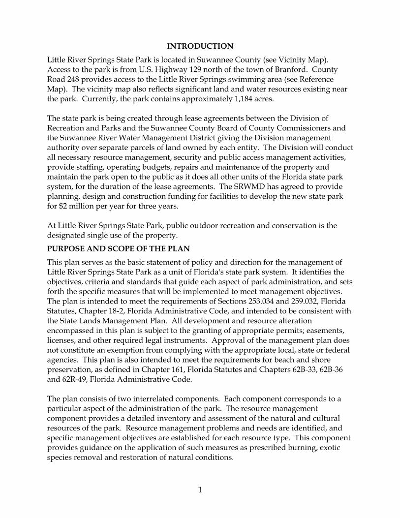
INTRODUCTION
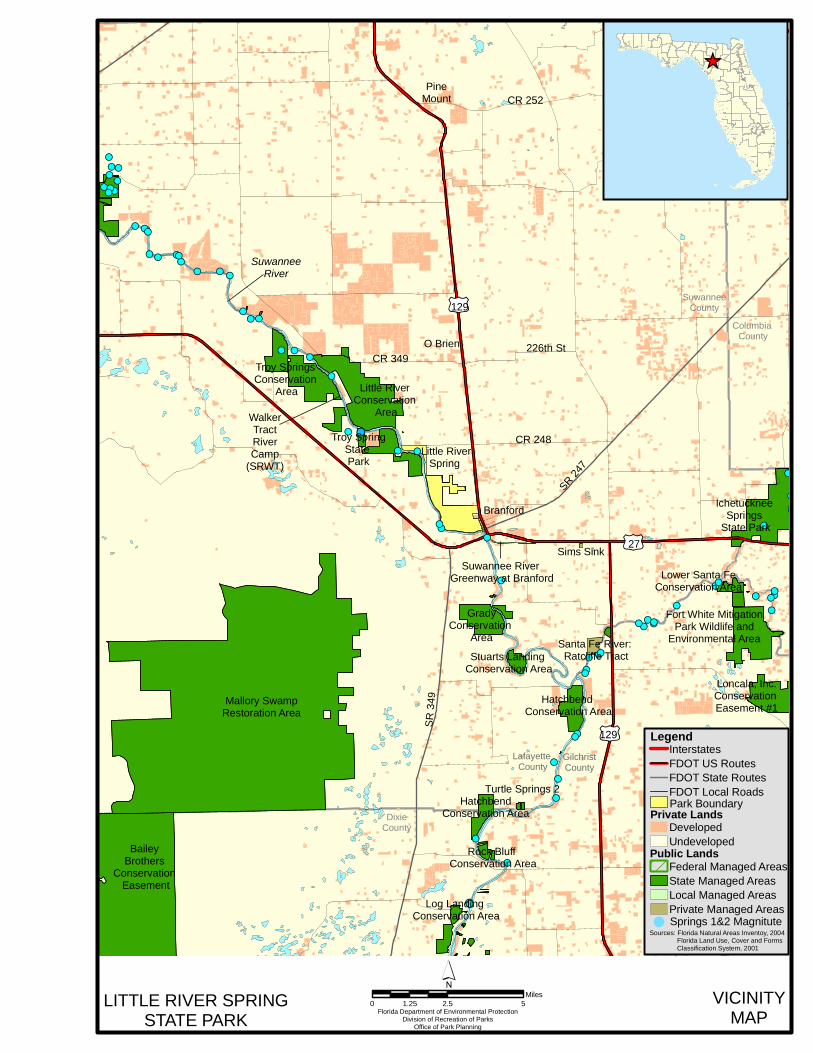
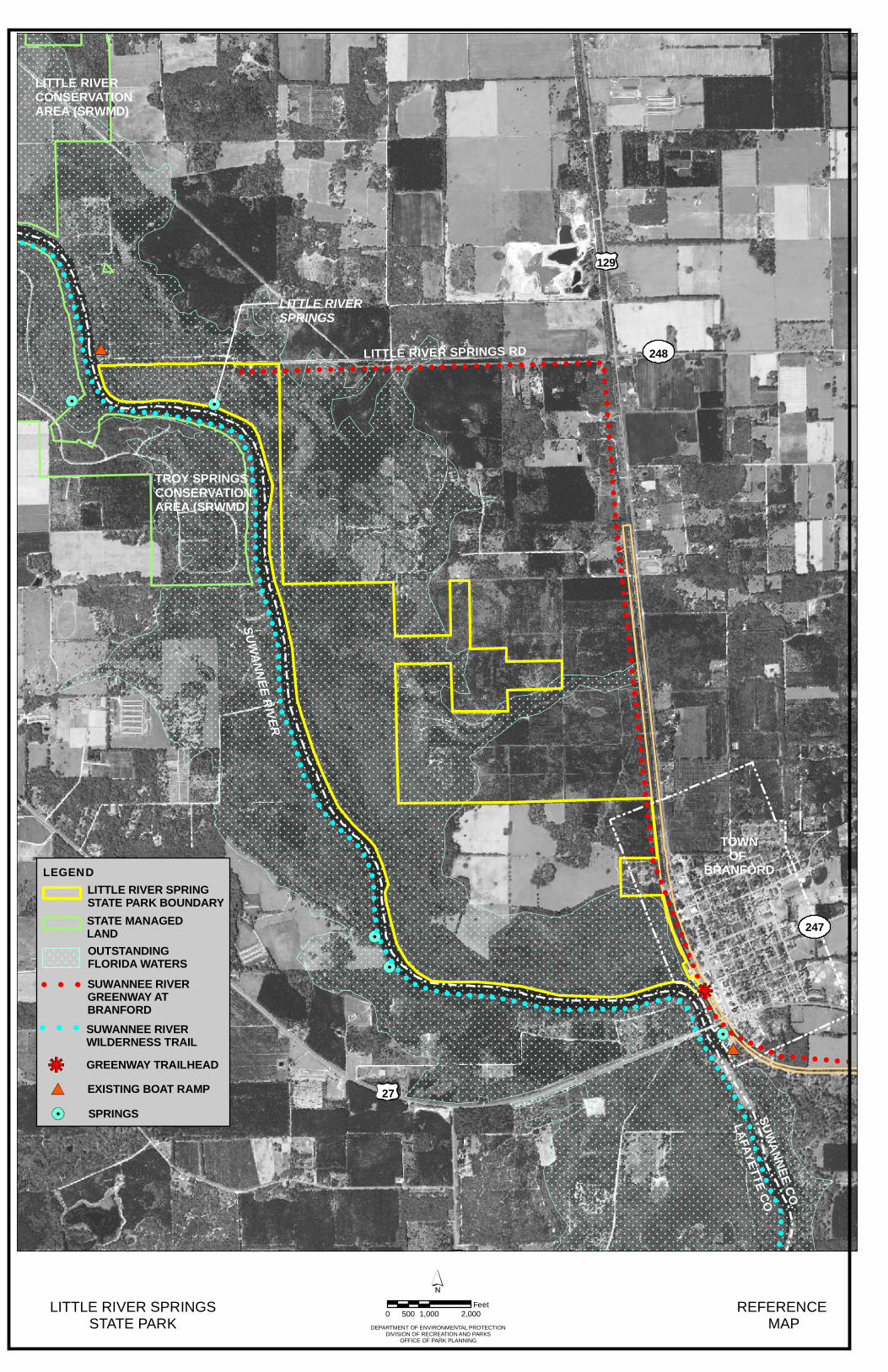
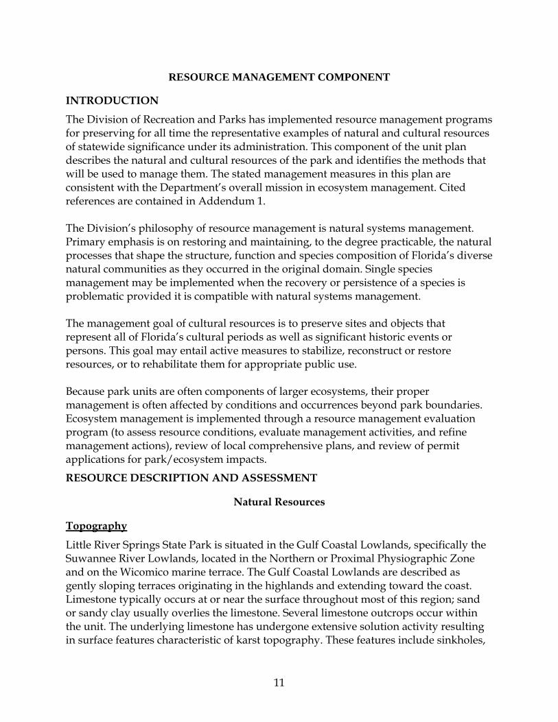
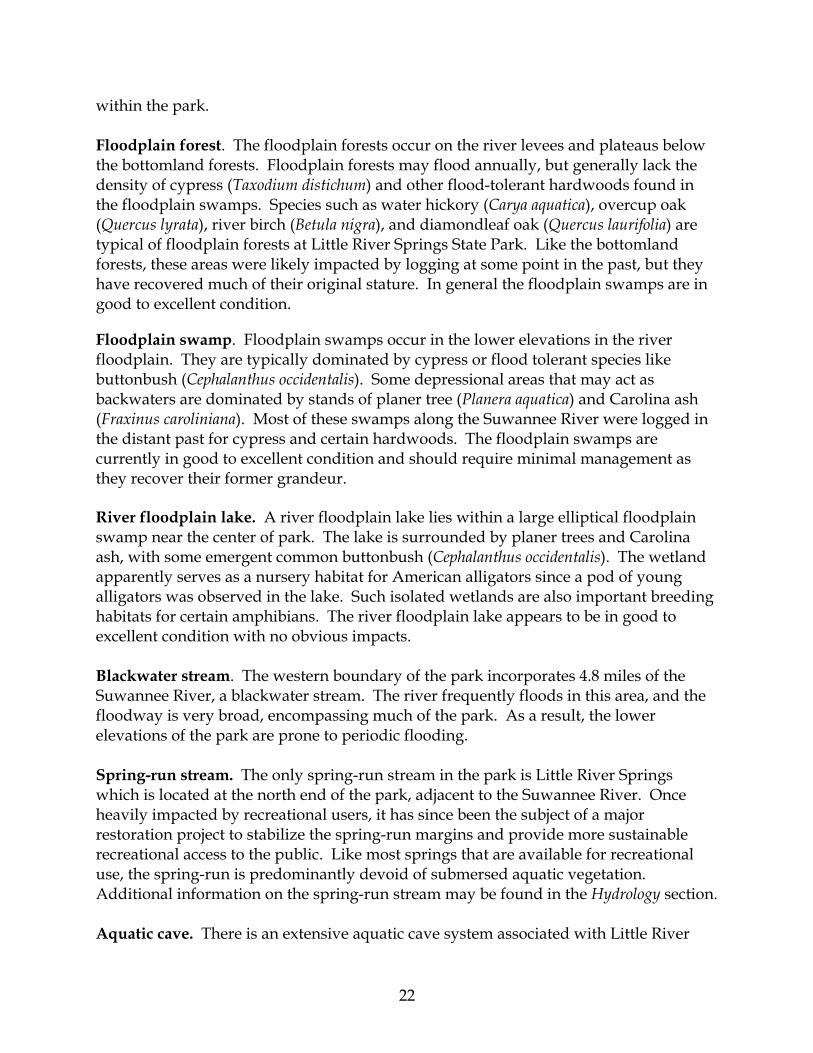
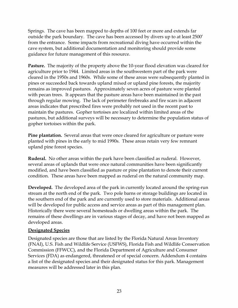
Little River Springs State Park is located in Suwannee County (see Vicinity Map). Access to the park is from U.S. Highway 129 north of the town of Branford. County Road 248 provides access to the Little River Springs swimming area (see Reference Map). The vicinity map also reflects significant land and water resources existing near the park. Currently, the park contains approximately 1,184 acres. The state park is being created through lease agreements between the Division of Recreation and Parks and the Suwannee County Board of County Commissioners and the Suwannee River Water Management District giving the Division management authority over separate parcels of land owned by each entity. The Division will conduct all necessary resource management, security and public access management activities, provide staffing, operating budgets, repairs and maintenance of the property and maintain the park open to the public as it does all other units of the Florida state park system, for the duration of the lease agreements. The SRWMD has agreed to provide planning, design and construction funding for facilities to develop the new state park for $2 million per year for three years. At Little River Springs State Park, public outdoor recreation and conservation is the designated single use of the property.
PURPOSE AND SCOPE OF THE PLAN
This plan serves as the basic statement of policy and direction for the management of Little River Springs State Park as a unit of Florida's state park system. It identifies the objectives, criteria and standards that guide each aspect of park administration, and sets forth the specific measures that will be implemented to meet management objectives. The plan is intended to meet the requirements of Sections 253.034 and 259.032, Florida Statutes, Chapter 18-2, Florida Administrative Code, and intended to be consistent with the State Lands Management Plan. All development and resource alteration encompassed in this plan is subject to the granting of appropriate permits; easements, licenses, and other required legal instruments. Approval of the management plan does not constitute an exemption from complying with the appropriate local, state or federal agencies. This plan is also intended to meet the requirements for beach and shore preservation, as defined in Chapter 161, Florida Statutes and Chapters 62B-33, 62B-36 and 62R-49, Florida Administrative Code. The plan consists of two interrelated components. Each component corresponds to a particular aspect of the administration of the park. The resource management component provides a detailed inventory and assessment of the natural and cultural resources of the park. Resource management problems and needs are identified, and specific management objectives are established for each resource type. This component provides guidance on the application of such measures as prescribed burning, exotic species removal and restoration of natural conditions.
#S
#S
#S
#S
#S#S
#S
#S
#S#S
#S#S
#S#S
#S#S
#S
#S
#S
#S
#S
#S
#S
#S#S
#S#S
#S
#S
#S
#S
#S
#S
#S
#S
#S
#S
#S
#S
#S#S
#S
#S
#S
#S
#S
#S
#S
#S
#S
#S
#S#S
#S
#S
#S#S
#S
#S
#S
#S
#S
#S
#S
#S
#S
#S#S
#S
#S
#S
#S#S
#S
#S
#S
#S
Little RiverSpring
GilchristCounty
£¤
£¤129
£¤
Mallory SwampRestoration Area
Bailey Brothers
Conservation Easement
Lafayette County
Ichetucknee Springs
State Park
CR 349
Little River Conservation
Area
Troy SpringsConservation
Area
GradyConservation
AreaFort White Mitigation
Park Wildlife andEnvironmental Area
Loncala, Inc.Conservation Easement #1Hatchbend
Conservation Area
WalkerTractRiverCamp
(SRWT)
Branford
HatchbendConservation Area
Columbia County
Log Landing Conservation Area
SuwanneeRiver
SuwanneeCounty
Stuarts Landing Conservation Area
Lower Santa FeConservation Area
CR 248
Santa Fe River: Ratcliffe Tract
Troy SpringState Park
SR 247
129
27
O Brien 226th St
Sims Sink
Rock Bluff Conservation Area
Suwannee River Greenway at Branford
SR 34
9
DixieCounty
Turtle Springs 2
PineMount CR 252
LITTLE RIVER SPRINGSTATE PARK
VICINITYMAPFlorida Department of Environmental Protection
Division of Recreation of ParksOffice of Park Planning
0 2.5 51.25Miles
´
_̂
Sources: Florida Natural Areas Inventoy, 2004 Florida Land Use, Cover and Forms Classification System, 2001
LegendInterstatesFDOT US RoutesFDOT State RoutesFDOT Local RoadsPark Boundary
Public Lands
Private Lands
Federal Managed AreasState Managed AreasLocal Managed AreasPrivate Managed Areas
DevelopedUndeveloped
Springs 1&2 Magnitute
TROY SPRINGS CONSERVATION AREA (SRWMD)
LITTLE RIVER CONSERVATION AREA (SRWMD)
TOWNOF
BRANFORD
LAFAYETTE CO.SUWANNEE CO.
SUWANNEE RIVER
LITTLE RIVERSPRINGS
248
129
247
27
349
LITTLE RIVER SPRINGS RD
DEPARTMENT OF ENVIRONMENTAL PROTECTIONDIVISION OF RECREATION AND PARKS
OFFICE OF PARK PLANNING
0 1,000 2,000500Feet REFERENCE
MAPLITTLE RIVER SPRINGS
STATE PARK
LEGEND
EXISTING BOAT RAMP
SUWANNEE RIVER WILDERNESS TRAIL
SUWANNEE RIVER GREENWAY AT BRANFORD
OUTSTANDING FLORIDA WATERS
STATE MANAGED LAND
SPRINGS
GREENWAY TRAILHEAD
LITTLE RIVER SPRING STATE PARK BOUNDARY
4
The land use component is the recreational resource allocation plan for the unit. Based on considerations such as access, population and adjacent land uses, an optimum allocation of the physical space of the park is made, locating use areas and proposing types of facilities and volume of use to be provided. In the development of this plan, the potential of the park to accommodate secondary management purposes (“multiple uses”) was analyzed. These secondary purposes were considered within the context of the Division’s statutory responsibilities and an analysis of the resource needs and values of the park. This analysis considered the park natural and cultural resources, management needs, aesthetic values, visitation and visitor experiences. For this park, it was determined that timber management for natural community restoration purposes could be accommodated in a manner that would be compatible and not interfere with the primary purpose of resource-based outdoor recreation and conservation. This compatible secondary management purpose is addressed in the Resource Management Component of the plan. Uses such as, water resource development projects, water supply projects, stormwater management projects, linear facilities and sustainable agriculture and forestry (other than those forest management activities specifically identified in this plan) are not consistent with this plan or the management purposes of the park and should be discouraged. The potential for generating revenue to enhance management was also analyzed. Visitor fees and charges are the principal source of revenue generated by the park. It was determined that timber management for natural community restoration purposes would be appropriate at this park as an additional source of revenue for land management since it is compatible with the park’s primary purpose of resource-based outdoor recreation and conservation. The use of private land managers to facilitate restoration and management of this unit was also analyzed. Decisions regarding this type of management (such as outsourcing, contracting with the private sector, use of volunteers, etc.) will be made on a case-by-case basis as necessity dictates.
MANAGEMENT PROGRAM OVERVIEW
Management Authority and Responsibility
In accordance with Chapter 258, Florida Statutes and Chapter 62D-2, Florida Administrative Code, the Division of Recreation and Parks (Division) is charged with the responsibility of developing and operating Florida's recreation and parks system. These are administered in accordance with the following policy:
It shall be the policy of the Division of Recreation and Parks to promote the state park system for the use, enjoyment, and benefit of the people of Florida and visitors; to acquire typical portions of the original domain of the state which will be accessible to all of the people, and of such character as to emblemize the state's natural values; conserve these natural values for all time; administer the development, use and maintenance of these lands and render such public service in so doing, in such a

5
manner as to enable the people of Florida and visitors to enjoy these values without depleting them; to contribute materially to the development of a strong mental, moral, and physical fiber in the people; to provide for perpetual preservation of historic sites and memorials of statewide significance and interpretation of their history to the people; to contribute to the tourist appeal of Florida.
The Trustees have also granted management authority of certain sovereign submerged lands to the Division under Management Agreement MA 68-086 (as amended January 19, 1988). The management area includes a 400-foot zone from the edge of mean high water where a park boundary borders sovereign submerged lands fronting beaches, bays, estuarine areas, rivers or streams. Where emergent wetland vegetation exists, the zone extends waterward 400 feet beyond the vegetation. The agreement is intended to provide additional protection to resources of the park and nearshore areas and to provide authority to manage activities that could adversely affect public recreational uses. Many operating procedures are standard system wide and are set by policy. These procedures are outlined in the Division’s Operations Manual (OM) that covers such areas as personnel management, uniforms and personal appearance, training, signs, communications, fiscal procedures, interpretation, concessions, camping regulations, resource management, law enforcement, protection, safety and maintenance. In the management of Little River Springs State Park, a balance is sought between the goals of maintaining and enhancing natural conditions and providing various recreational opportunities. Natural resource management activities are aimed at management of natural systems. Development in the park is directed toward providing public access to and within the park, and to providing recreational facilities, in a reasonable balance, that are both convenient and safe. Program emphasis is on interpretation on the park's natural, aesthetic and educational attributes.
Park Goals and Objectives
The following park goals and objectives express the Division’s long-term intent in managing the state park. At the beginning of the process to update this management plan, the Division reviewed the goals and objectives of the previous plan to determine if they remain meaningful and practical and should be included in the updated plan. This process ensures that the goals and objectives for the park remain relevant over time. Estimates are developed for the funding and staff resources needed to implement the management plan based on these goals, objectives and priority management activities. Funding priorities for all state park management and development activities are reviewed each year as part of the Division’s legislative budget process. The Division prepares an annual legislative budget request based on the priorities established for the entire state park system. The Division also aggressively pursues a wide range of other funds and staffing resources, such as grants, volunteers and partnerships with agencies, local governments and the private sector, for supplementing normal legislative appropriations to address unmet needs. The ability of the Division to implement the

6
specific goals, objectives and priority actions identified in this plan will be determined by the availability of funding resources for these purposes.
Natural Resources
1. Support efforts to decrease nitrate levels in the groundwater and spring discharge. A. Continue to cooperate with SRWMD and FDEP nitrate level monitoring
efforts and track the results of nitrate monitoring in the spring. B. Encourage research to investigate a probable correlation between increasing
nitrate levels and any adverse impacts observed in the spring. C. Identify the recharge area, or area of groundwater influence, for Little River
Springs, and determine point and non-point sources of nitrate pollution for the spring.
2. Seek funding for implementation of automated spring flow monitoring and data collection.
3. Identify and seek to resolve issues relating to outside development and existing and proposed park facilities that may negatively affect water resources within the park. A. Maintain viable contacts with water resource managers and permitting agents
in the SRWMD. When appropriate, provide technical comments pertaining to the issuance of consumptive water use permits and water preservation rule making which may affect the long-term protection of water resources within the park.
B. Assess existing portable restroom facilities regularly to ensure they are operating correctly. Employ the most advanced wastewater treatment possible in all future development of park facilities.
C. Seek to improve treatment of stormwater runoff in existing developed areas, and ensure that future development adequately addresses stormwater treatment. Design, build and maintain facilities in such a way as to minimize associated erosion.
D. Restrict development in the 100-year floodplain to the minimum necessary to meet recreational goals while providing adequate protection to floodplain areas and maintaining the natural floodway.
E. Permanent, traditional full-service rest room facilities will not be constructed within the 100-year floodplain. Portable rest room facilities will be removed whenever there is imminent danger of the Suwannee River flooding.
4. Establish and maintain prescribed fire program. A. A prescribed fire program will be established at the park to initiate restoration
of fire-adapted natural communities and to manage disturbed areas such as pastures and pine plantations.
B. Existing firebreaks will be inventoried and improved or extended as necessary to conduct prescribed fires in a safe and prudent manner.
C. Mechanical or chemical treatment of vegetation will be conducted when needed to allow the use of prescribed fire.
D. The park will be provided with fire equipment necessary to conduct prescribed burns according to Division standards.
7
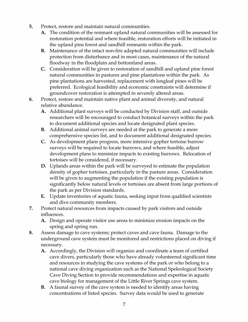
5. Protect, restore and maintain natural communities. A. The condition of the remnant upland natural communities will be assessed for
restoration potential and where feasible, restoration efforts will be initiated in the upland pine forest and sandhill remnants within the park.
B. Maintenance of the intact non-fire adapted natural communities will include protection from disturbance and in most cases, maintenance of the natural floodway in the floodplain and bottomland areas.
C. Consideration will be given to restoration of sandhill and upland pine forest natural communities in pastures and pine plantations within the park. As pine plantations are harvested, replacement with longleaf pines will be preferred. Ecological feasibility and economic constraints will determine if groundcover restoration is attempted in severely altered areas.
6. Protect, restore and maintain native plant and animal diversity, and natural relative abundance. A. Additional plant surveys will be conducted by Division staff, and outside
researchers will be encouraged to conduct botanical surveys within the park to document additional species and locate designated plant species.
B. Additional animal surveys are needed at the park to generate a more comprehensive species list, and to document additional designated species.
C. As development plans progress, more intensive gopher tortoise burrow surveys will be required to locate burrows, and where feasible, adjust development plans to minimize impacts to existing burrows. Relocation of tortoises will be considered, if necessary.
D. Uplands areas within the park will be surveyed to estimate the population density of gopher tortoises, particularly in the pasture areas. Consideration will be given to augmenting the population if the existing population is significantly below natural levels or tortoises are absent from large portions of the park as per Division standards.
E. Update inventories of aquatic fauna, seeking input from qualified scientists and dive community members.
7. Protect natural resources from impacts caused by park visitors and outside influences. A. Design and operate visitor use areas to minimize erosion impacts on the
spring and spring run. 8. Assess damage to cave systems; protect caves and cave fauna. Damage to the
underground cave system must be monitored and restrictions placed on diving if necessary. A. Accordingly, the Division will organize and coordinate a team of certified
cave divers, particularly those who have already volunteered significant time and resources in studying the cave systems of the park or who belong to a national cave diving organization such as the National Speleological Society Cave Diving Section to provide recommendations and expertise in aquatic cave biology for management of the Little River Springs cave system.
B. A faunal survey of the cave system is needed to identify areas having concentrations of listed species. Survey data would be used to generate

8
recommendations for the protection of troglobites, i.e. the setting aside of restricted areas and the determination of appropriate numbers of divers for the caves.
C. A check-in system will need to be devised to track daily cave use. Unauthorized access to the cave system by non-cave certified divers must be prevented for resource as well as safety concerns.
D. Design and implement a regular cave monitoring protocol to assess impacts to the aquatic cave system from park visitors. If necessary, take measures to stop and reverse, or mitigate significant impacts. The Division will actively seek the funding necessary to accomplish the baseline surveys and the follow-up monitoring. One potential source of funding is the Florida Springs Initiative.
E. An interpretive program should be initiated, working with the National Association of Cave Divers and the National Speleological Society Cave Diving Section to educate cave divers about cave preservation and proper behavior within caves. A series of guidelines should be promulgated and posted to identify detrimental activities that are forbidden, including, but not limited to, purposeful disturbance of the silt layers and the use of motorized diving scooters within the cave system.
9. Establish and maintain invasive exotic plant and animal species removal programs. A. The park will continue the exotic plant removal program instituted by the
SRWMD. Emphasis will be placed on control and removal of EPPC Category I species such as Japanese climbing fern (Lygodium japonicum) and Chinese tallowtree (Sapium sebiferum).
B. The park will need to establish a feral hog removal program. Control methods will be determined after an assessment of feral hog damage and population levels.
10. Protect park boundaries to improve resource management and avoid encroachment. A. Posting of the park boundary will be essential for protection of park
boundaries. Fencing will be necessary in most areas. B. An assessment of the park’s optimum boundary will be necessary to
determine any lands that should be added to the park to improve park operations and protect and enhance existing park lands.
Cultural Resources
1. Staff should pursue a comprehensive cultural resource survey and protect known resources. A. Conduct a comprehensive Phase I survey of the park to identify unknown and
known sites and their extent. B. Conduct a phase I survey of the undocumented historic structures. C. Develop written procedures for managing cultural resources.
2. Document concerns about the decline of historic structures. A. Develop and implement plans to stabilize the older tobacco barn if necessary. B. Request approval from DHR to document and remove the two ruins at 8SU

9
188, the turpentine cabin and the unknown structure at the tobacco barn site. 3. Determine if potential National Historic Register Sites qualify.
A. Pursue funding to determine if the archaeological site 8SU8 qualifies for listing on the National Register of Historic Places.
4. Develop interpretation of cultural resources. A. Implement interpretive methods for the park’s cultural resources. B. Implement a protection and monitoring plan for the cultural resources.
Recreational Goals
1. Provide quality resource based outdoor recreational and interpretive programs and facilities at the state park and support the Suwannee River Wilderness Trail HUB at Branford.
2. Continue operation of Little River Springs Park for day use public swimming, SCUBA diving, canoeing, kayaking, picnicking and fishing as established by the park's current operation by the Live Oak, Suwannee County Recreation Board.
3. Seek funding to expand recreational and interpretive opportunities through the improvement of programs and the development of new use areas and facilities, as outlined in this management plan. Facilities should include up to 60 sites for standard RV camping, restroom and camping platform facilities adjacent to the river (the River Camp), boat docking and canoe/kayak landing and storage facilities, vacation cabins, trails and trailhead facilities for hikers, bikers and equestrians, picnic facilities, interpretive kiosks and other park amenities.
Park Administration/Operations
1. Provide staff for park operations and natural resource management and protection.
Management Coordination
The park is managed in accordance with all applicable Florida Statutes and administrative rules. Agencies having a major or direct role in the management of the park are discussed in this plan. The Department of Agriculture and Consumer Services, Division of Forestry (DOF), assists Division staff in the development of wildfire emergency plans and provides the authorization required for prescribed burning. The Florida Fish and Wildlife Conservation Commission (FFWCC), assists staff in the enforcement of state laws pertaining to wildlife, freshwater fish and other aquatic life existing within park boundaries. In addition, the FFWCC aids the Division with wildlife management programs, including the development and management of Watchable Wildlife programs. The Department of State, Division of Historical Resources (DHR) assists staff to assure protection of archaeological and historical sites. The Department of Environmental Protection (DEP), Office of Coastal and Aquatic Managed Areas (CAMA) aids staff in aquatic preserves management programs. Close coordination in management of this park will be maintained by Division staff with staff of the Suwannee River Water Management District on issues related to the

10
District land under lease to the Division and to the management and coordination of activities on the Suwannee River Wilderness Trail. Likewise, Division staff will work closely with Suwannee County staff on issues related to the management and protection of resources on the County-owned land. Approximately 120 acres of the Suwannee County parcel was acquired in 1996 under a grant agreement between Suwannee County and the Florida Department of Community Affairs, Florida Communities Trust (FCT) grant program. Division staff has incorporated features of the County's management plan for the FCT parcel into this management plan for the state park, and have included FCT staff in the review cycle of this management plan. Division staff will assume the County's responsibilities for resource protection, monitoring and reporting as they are outlined in the Little River Springs Management Plan submitted by the County to the FCT in August 1996.
Public Participation
The Division provided an opportunity for public input by conducting a public workshop on Thursday, December 6, 2007 in the Branford.
Other Designations
Little River Springs State Park is not within an Area of Critical State Concern as defined in section 380.05, Florida Statutes and it is not under study for such designation. The park is a component of the Florida Greenways and Trails System. All waters within the unit have been designated as Outstanding Florida Waters, pursuant to Chapter 62-302 Florida Administrative Code. Surface waters in this unit are also classified as Class III waters by DEP. This unit is not adjacent to an aquatic preserve as designated under the Florida Aquatic Preserve Act of 1975 (section 258.35, Florida Statutes).
11
RESOURCE MANAGEMENT COMPONENT
INTRODUCTION
The Division of Recreation and Parks has implemented resource management programs for preserving for all time the representative examples of natural and cultural resources of statewide significance under its administration. This component of the unit plan describes the natural and cultural resources of the park and identifies the methods that will be used to manage them. The stated management measures in this plan are consistent with the Department’s overall mission in ecosystem management. Cited references are contained in Addendum 1. The Division’s philosophy of resource management is natural systems management. Primary emphasis is on restoring and maintaining, to the degree practicable, the natural processes that shape the structure, function and species composition of Florida’s diverse natural communities as they occurred in the original domain. Single species management may be implemented when the recovery or persistence of a species is problematic provided it is compatible with natural systems management. The management goal of cultural resources is to preserve sites and objects that represent all of Florida’s cultural periods as well as significant historic events or persons. This goal may entail active measures to stabilize, reconstruct or restore resources, or to rehabilitate them for appropriate public use. Because park units are often components of larger ecosystems, their proper management is often affected by conditions and occurrences beyond park boundaries. Ecosystem management is implemented through a resource management evaluation program (to assess resource conditions, evaluate management activities, and refine management actions), review of local comprehensive plans, and review of permit applications for park/ecosystem impacts.
RESOURCE DESCRIPTION AND ASSESSMENT
Natural Resources
Topography
Little River Springs State Park is situated in the Gulf Coastal Lowlands, specifically the Suwannee River Lowlands, located in the Northern or Proximal Physiographic Zone and on the Wicomico marine terrace. The Gulf Coastal Lowlands are described as gently sloping terraces originating in the highlands and extending toward the coast. Limestone typically occurs at or near the surface throughout most of this region; sand or sandy clay usually overlies the limestone. Several limestone outcrops occur within the unit. The underlying limestone has undergone extensive solution activity resulting in surface features characteristic of karst topography. These features include sinkholes,

12
springs, and depressions caused by the collapse of the upper layers of material into underlying solution voids and caverns. Elevations within the unit, according to U.S. Geological Survey quadrangle maps, range from 20 feet above mean sea level (msl) along the Suwannee River during normal water levels to just over 40 feet above msl in the uplands (see Topographic Map). Eighty-two percent of the unit lies within the 100-year floodplain as calculated by the Suwannee River Water Management District for this reach of the Suwannee River. About 72 Percent of the park is within the 10-year floodplain. Only a few alterations of the natural topography have occurred in the past. In several areas an old road or tramway that parallels the Suwannee River has been built up within the floodplain forests and swamps. Although this may have been located on a natural rise or levee within the floodplain, it has been culverted in places and modified to some degree. Limited modifications to the natural channels within the floodplain swamp have also been made at the southern end of the park. Several unimproved roads access the primary river levees from the uplands and pass through the floodplain areas perpendicular to the Suwannee River. Some sections of these roads have been raised within the floodplain and may affect the local hydrology.
Geology
Geologic strata underlying Little River Springs State Park include, from youngest to oldest: surficial marine deposits, Alachua Formation, Hawthorn Group, St. Marks Formation, Suwannee Limestone, Ocala Group, Avon Park Limestone, Lake City Limestone, Oldsmar Limestone, and Cedar Key Limestone (Crane, 1986). Limestone (probably Suwannee Limestone) is exposed at the surface, where upper deposits have eroded away. The upper surficial material contains Recent Age deposits mixed with Pleistocene Age sediments that were laid down as terraces by fluctuating sea levels during successive glacial periods. These Pleistocene deposits are mostly fine-grained sands, clayey at the surface, but coarser with increasing depth. Large pebbles of phosphate and quartz are commonly found at the base of the sand layer. The Recent and Pleistocene deposits may reach 30 feet in thickness. The Alachua Formation, of Miocene or Pliocene Age, consists of sandy clay and sand beds that are not as calcareous and phosphatic as similar beds in the underlying Hawthorn Group. Silicified pieces of the underlying limestone are generally incorporated in beds near the base of the formation. The Alachua Formation ranges to 150 feet in thickness. The Hawthorn Group, also of Miocene Age, contains sandy clay that is interbedded with hard phosphatic or dolomitic limestone layers and fine to coarse phosphatic sands. The color of the clay varies from dark green or black, to light green or gray. Hawthorn

13
Group deposits may reach a thickness of 150 feet. Suwannee Limestone consists of white to yellow-gray and pale orange limestone interbedded with dolomitic limestone and dolomite. The deposits are composed of varying amounts of echinoid and molluskan fragments, and foraminifera. This layer can be up to 190 feet thick. The Ocala Group, an Eocene deposit, actually consists of three limestone formations of similar character. In order of increasing age these are the Crystal River, Williston, and Inglis Formations. The limestone of the Ocala Group varies from a loose, porous, cream to white-colored coquina, composed of large foraminifera and shells, to a solution-riddled, echinoid-rich brown limestone. The deposit ranges in thickness from 150 to 250 feet. Avon Park Limestone consists of alternate layers of dark brown dolomite and chalky limestone, both of which may contain chert and gypsum. This formation varies from 170 to 270 feet in thickness. The Lake City Limestone, another Eocene formation, is composed of alternate layers of dark brown dolomite and chalky limestone, both of which may contain chert and gypsum. Gypsum and anhydrite may occur at the base of the formation. The Lake City Limestone reaches 500 feet in thickness. The last formation of Eocene Age is Oldsmar Limestone. The top half of the formation is a very porous, brown limestone with some gypsum and anhydrite, while the bottom half is a thick zone of dolomite with chert or anhydrite. Oldsmar Limestone ranges between 250 and 350 feet in thickness. The Cedar Keys Limestone is a Paleocene deposit. Its lower section has a dolomitic composition, while a distinct marker bed of clay occurs near the middle of the deposit. The greater part of the formation consists of gray, white or brown, dense to porous, fragmental limestone impregnated with gypsum and anhydrite. Red calcareous clay and purite may be present in some localities. This formation may be 400 to 450 feet in thickness.
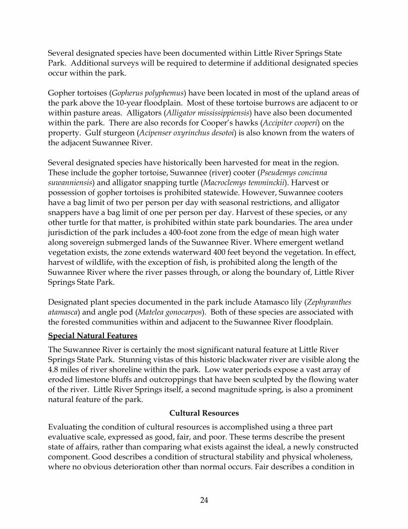
Soils
Eight soil types occur within Little River Springs State Park (see Soils Map) according to the Soil Survey for Suwannee County (Weatherspoon 2006). Addendum 2 contains complete descriptions of these soils. Most of the soils within the park are relatively stable and soil erosion is minimal; however, portions of the shoreline along the spring run suffered from significant erosion in the past due to recreational use. A major reconstruction and restoration of

7
7
74
74
10
7119
10
41
10
74
18
1174
7
LEGEND7-Bigbee-Garcon-Meggett complex, 0 to 5 percent slopes10-Blanton-Alpin complex, 0 to 5 percent slopes11-Bonneau-Blanton-Padlock complex, 0 to 5 percent slopes18-Oleta-Chiefland-Ichetucknee complex, 0 to 5 percent slopes19-Chiefland fine sand, occasionally flooded41-Fluvaquents-Meggett-Bigbee complex, frequently flooded71-Otela-Alpin-Chiefland complex, 0 to 5 percent slopes74-Surrency, Plummer, and Cantey soils, frequently floodedWater
LITTLE RIVER SPRINGSSTATE PARK SOILS
MAPFlorida Department of Environmental ProtectionDivision of Recreation and Parks
Office of Park Planning
0 1,000 2,000500Feet
´
15
the spring run has alleviated many of the erosion problems. A series of boardwalks and stairs allow public access. Some erosion is still occurring, particularly during low water periods. Monitoring of visitor use patterns will be necessary to determine future erosion control measures. Management activities will follow generally accepted best management practices to prevent additional soil erosion and conserve soil and water resources on site.
Minerals
Limestone outcroppings occur along the banks of the Suwannee River, but whether or not mineral deposits of commercial value exist in the area is unknown.
Hydrology
Little River Springs State Park is located in southwestern Suwannee County within Florida’s Gulf Coastal Lowlands physiographic region (White 1970) and stretches along the third reach (SRWMD 2005) of the Middle Suwannee River basin (Hornsby et al. 2002). The entire Suwannee River basin drains approximately 10,000 square miles in Florida and Georgia. Water in this system has an average flow of 7,100 million gallons per day (mgd) that ultimately discharges from the Suwannee River into the Gulf of Mexico. The Suwannee River is designated an Outstanding Florida Water. Average annual rainfall for this region approaches 60 inches a year (Fernald and Purdum 1998) Regionally within the Middle Suwannee River (MSR) basin, the upper Floridan aquifer is near the surface and is unconfined (Florida Geological Survey 1991). Numerous springs in the exposed limestone of the aquifer discharge into the Suwannee River and significantly augment its flow in this region. For example, within the MSR, groundwater is the source of nearly all inflow to the river (Pittman et al. 1997). Spring flow constitutes about half of the river’s discharge, and other groundwater sources account for the remaining amounts in this region. During flood stage, however, this cycle reverses and springs subsequently act as “siphons” or inflow points into the upper Floridan aquifer. Substantial nitrate loading and other related water quality issues have emerged from research associated with river and groundwater mixing along this reach of Suwannee River (Katz et al. 1999; Katz and Hornsby 1998; Berndt et al. 1998; Pittman et al. 1997). In addition to the Suwannee River, surface water bodies in the park include a spring and spring run stream, several sinkhole ponds, a floodplain lake, and intermittent blackwater streams. Little River Springs State Park is located between river miles 76 and 81 of the Suwannee River. The park encompasses 4.8 miles of river shoreline. The SRWMD has calculated the following flood elevations for this section of the river for 2, 10, and 100-year events. All data are expressed as feet above msl. Since a majority of the park lies at or below 29 feet msl (designated as flood stage), it is subject to frequent river flooding, often resulting in the inundation of much of the

16
Event
River Mile 2-year 10-year 100-year Flood of Record
76 24 33 37 38 77 24 33 38 40 78 25 34 38 40 79 25 34 39 40 80 26 34 39 41 81 26 35 40 42
property including Little River Springs on the north end of the park. Based upon historic river elevation data at the USGS Branford gage (#02320500), located at the southern end of the park, the river has reached or exceeded 29 feet above msl 12 times in the past 80 years. This indicates the park has a one in six chance of flooding in any given year (SRWMD website data). One interesting habitat feature of the park is a highly dynamic intermittent blackwater stream that bisects the topography of this region. A small portion of this ephemeral creek system crosses park property for about 1,000 feet before discharging into the Suwannee River. Potential water quality issues such as stormwater runoff, or agricultural fertilizers or pesticides could result from the direct connection of this creek to SR 129 and the rural areas surrounding the town of Branford. Little River Springs, which is a second magnitude spring vent, is another very prominent feature of the property (Scott et al. 2004). It is the only known spring in the park. The spring pool measures 108 ft north to south and 93 ft east to west. Limestone is exposed in the pool and spring water flows from a large boil that discharges to the Suwannee River through a 150-foot spring-run stream. An extensive cave system below the pool reaches depths of up to 125 ft (Wes Skiles pers. comm.). Preliminary investigations by divers and hydrologists have begun to unravel the underground intricacies of this cave system. Groundwater feeding Little River Springs appears to come from three sources, west from Lafayette County, east from Suwannee County and also an undefined deep-water source (Wes Skiles pers. comm.). One realistic spring inflow from the east source is located 6 miles northeast of the spring at a sinking stream called “Little River.” This stream was likely the feature that gave the spring its name. Several miles of cave exploration have been done in this east source: “Stick Sink Swallet,” and the “Register Cave” (Wes Skiles pers. comm.). The relationship of Stick Sink, Little River and Little River Springs appears very similar to the scenario at Rose Sink, Rose Creek, and its known spring discharge points into the Ichetucknee Springs Group. Dye tracer work in these east sources should be a future priority investigation to further understand specific groundwater connections to Little River Springs. During drought periods, the contribution of east source flow to Little River Springs appears to
17
decrease in significance (10-20 percent total discharge), whereas during periods of high discharge the reverse is true (total discharge of up to 60 percent). The deep-water source flow appears to be more consistent year round regardless of regional recharge (Wes Skiles pers. comm.). The SRWMD along with cooperating agencies such as the USGS, maintain the Water Assessment Regional Network (WARN) to monitor river, lake, and groundwater levels, river discharge, rainfall, and surface and groundwater quality conditions (Suwannee River Hydrologic Observatory 1997). They analyze basin-wide water trends in order to forecast future water quantity and quality conditions. Data from WARN supports decision making efforts of consumptive use permitting, water supply projects, watershed planning and management projects, and is used in the development of minimum flows and levels. Sporadic surfacewater quality data exists for Little River Springs as far back as 1976 (Various sources, District 2 files). Since 1998, SRWMD has collected monthly samples from Little River Springs for water chemistry and bimonthly discharge measurements (Hornsby et al. 2002). In 2000, the Florida Department of Environmental Protection enacted a statewide watershed management program (Integrated Water Resource Monitoring) as part of a process of implementing requirements of the 1999 Florida Watershed Restoration Act and Section 303(d) of the Federal Clean Water Act (Florida Department Environmental Protection 2005). This program is a comprehensive approach to monitoring Florida’s water resources based on natural hydrologic units. There are 52 hydrologic basins in Florida. This approach provides a framework for implementing Total Maximum Daily Load (TMDL) requirements for restoring and protecting water quality of a specific watershed. Including this watershed program, analysis of water monitoring data for the Suwannee River has a long history associated with understanding nutrient loading throughout the basin (Berndt et al. 1998; Hand et al. 1996; Kenner et al. 1991; Ham and Hatzell 1996). Traditionally increased nutrient loads in the Middle Suwannee River (Reach 3) have elicited much research over the years (Berndt et al., 1998, Fernald and Purdum, 1998). Significant trends concerning nitrate-nitrogen and phosphorus concentrations have been of primary concern (SRWMD data 1999-2003 in District 2 files; Ham and Hatzell 1996). There is a strong correlation between increased nutrients and periphyton growth in the Suwannee (Hornsby et al. 1999). Groundwater appears to be the largest contributor of the nutrient loading problem in the MSR (Hornsby et al. 1999). Groundwater resources may be vulnerable to degradation in the area of the park because here the Floridan aquifer is unconfined and runoff can freely enter the aquifer via countless sinkholes and karst windows. Because of the unconfined nature of the aquifer and the importance of spring inflow to the Suwannee River, the result of non-point sources such as fertilizers used in agriculture, stormwater runoff, and malfunctioning septic tanks, has been continuously deteriorated surfacewater quality in

18
the MSR (Katz et al. 1999; Katz and Hornsby 1998; Berndt et al. 1998; Pittman et al. 1997). Known records of nitrate-nitrogen levels in Little River Springs have ranged from 0.40 to 3.02 mg/L and an average of 1.24 mg/L (Various sources, District 2 files). Under the SRWMD rating system, water quality for the spring has been consistently reported as “fair” (SRWMD data 1999-2003 in District 2 files; Hornsby and Mattson 1997). Surfacewater quality analysis by FDEP of nearby springs in the MSR have been rated as “poor” and determined to not meet standards for Class III waters (Hand et al. 1996). It should be noted that the SRWMD and FDEP have based each of their rating systems on different scales (below, Hornsby et al. 1999).
Good Fair Poor FDEP < or = to 0.5 mg/L 0.5 to 1.0 mg/L > than 1 mg/L SRWMD < or = to 0.6 mg/L 0.6 to 1.8 mg/L > than 1.8 mg/L
Water resources within the park may be threatened by large-scale withdrawals from surface or groundwater systems hydraulically connected to systems within the park. The SRWMD is responsible for issuing water use permits in the region, and in doing so must ensure that proposed uses are in the public interest, which includes the conservation of fish and wildlife habitat and the protection of recreational values. Current trends in drought levels and increasing consumptive use of groundwater resources have created a strong concern among scientists of lowered water tables and decreased spring flows throughout the Suwannee River Basin. Given projected water supply needs for the area, the USGS predicts flows in springs throughout the state, including Little River Springs, will continue to decline (Sepulveda, 2002). The SRWMD is also responsible for prioritizing and establishing Minimum Flows and Levels (MFLs) for water bodies within its boundaries. The SRWMD is currently developing a MFL for the Middle Suwannee River with a completion deadline due by the end of 2008.
Natural Communities
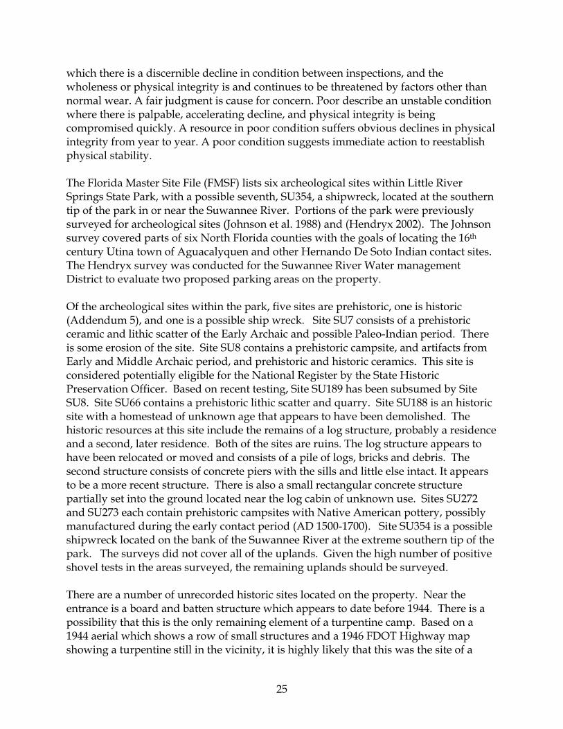
The system of classifying natural communities employed in this plan was developed by the Florida Natural Areas Inventory (FNAI). The premise of this system is that physical factors, such as climate, geology, soil, hydrology and fire frequency generally determine the species composition of an area, and that areas which are similar with respect to these factors will tend to have natural communities with similar species compositions. Obvious differences in species composition can occur, despite similar physical conditions. In other instances, physical factors are substantially different, yet the species compositions are quite similar. For example, coastal strand and scrub--two communities with similar species compositions--generally have quite different climatic environments, and these necessitate different management programs. The park contains 12 distinct natural communities (see Natural Communities Map) in

84
29
29
22
35
33
22
23
22
84
29
33
31
14
33
33
24
14
24
35
24
22
85
35
35
33
8522
57
50
18
LEGEND14 - Sandhill-57.92 ac.18 - Sinkhole-0.53 ac.22 - Upland Mixed Forest-207.16 ac.23 - Upland Pine Forest-57.66 ac.24 - Xeric Hammock-46.23 ac.29 - Bottomland Forest-253.16 ac.31 - Depression Marsh-0.16 ac.33 - Floodplain Forest-190.35 ac.35 - Floodplain Swamp-132.47 ac.50 - River Floodplain Lake-0.47 ac.57 - Spring-Run Stream-0.68 ac.84 - Ruderal-234.19 ac.85 - Developed-3.06 ac.
LITTLE RIVER SPRINGSSTATE PARK NATURAL COMMUNITIES
MAPFlorida Department of Environmental ProtectionDivision of Recreation and Parks
Office of Park Planning
0 1,000 2,000500Feet
´

20
addition to ruderal and developed areas. Park specific assessments of the existing natural communities are provided in the narrative below. A list of plants and animals occurring in the unit is contained in Addendum 3. Sandhill. The sandhill natural community occurs at higher elevations in the east central portion of the park. Characterized by well-drained soils, these areas have retained scattered remnant canopy tree species such as longleaf pine (Pinus palustris), turkey oak (Quercus laevis) and bluejack oak (Quercus incana). Although wiregrass also occurs in small amounts in these areas, most of the native groundcover is absent. In most of the sandhill areas, non-fire adapted hardwoods, like laurel oaks (Quercus laurifolia), have invaded due to extended periods of fire exclusion. Several gopher tortoise burrows were noted within the sandhill areas. Restoration of these areas will require extension replanting of native sandhill species. The sandhill areas are in general considered to be in poor condition due to the loss of the groundcover species. Most areas will also require extensive replanting with longleaf pines. Sinkhole. There are sinkholes of varying sizes and depths scattered through the park. Several located near the eastern boundary near former residences, have been impacted by debris dumping and exotic plants. While the debris has been removed and the exotic plant species have been controlled, the sinkholes bear the scars of previous disturbances. Sinkholes or shallow karst depressions also occur within the wooded areas within the cleared pastures. These have suffered from some degree of disturbance from the clearing of the original forests and the use of the land for agriculture and livestock grazing. The sinkholes in the best condition occur within the floodplain and bottomland communities. Like the surrounding forests, these sinkholes have suffered very few impacts. Upland Mixed Forest. The upland mixed forests occur upslope of the bottomland and floodplain forests, and host a wider diversity of plant species. Although dominated by hardwoods, some loblolly pines also occur within this community type. The examples in the best condition are located below the 100-year flood elevation. These stands are characterized by a closed canopy forest with a wide diversity of tree species. The upland mixed forests that are located at higher elevations may actually represent advanced successional areas that were once upland pine forest or sandhill. Most of these areas were heavily disturbed in the past, and may have once been converted to pasture or other agricultural uses. In some cases there are remnants of pine plantations that have been grown over with hardwoods. The upland mixed forests associated with the floodplain areas are in good to excellent condition, while those in the upland areas are much more impacted by agricultural pursuits. Some of these areas represent successional stages of disturbed natural communities and have relatively low species diversity. Such areas are considered to be in poor condition. Upland pine forest. This community type occurs on the higher elevations, nearly all of
21
it above the 100-year flood elevation. Once dominated by longleaf pine with a wiregrass and herbaceous groundcover, the upland pine forests were logged in the past and subjected to extended periods of fire exclusion. It is likely that some areas were grazed by livestock. Very few examples of the characteristic groundcover species remain. The tree canopy is dominated by fire intolerant hardwoods, such as laurel oak, Carolina laurelcherry (Prunus caroliniana), and sweetgum (Liquidambar styraciflua). Scattered sand post oaks (Quercus margaretta) remain to attest to the original nature of the community. The areas mapped as upland pine forest are considered to be in poor condition due to the lack of natural groundcover and the loss of the longleaf pine overstory. Xeric hammock. Several areas classified as xeric hammock occur on rises within the 10-year floodplain. These areas are characterized by an open overstory of sand live oaks (Quercus geminata) with an understory dominated by sparkleberry (Vaccinium arboreum), titi (Cyrilla racemiflora), highbush blueberry (Vaccinium corymbosum), and saw palmetto (Serenoa repens). These areas appear to be on better drained sandy soils that flood less frequently than the surrounding upland mixed forest and bottomland forest. While not exactly fitting the description of xeric hammock (FNAI/FDNR 1990), that classification seems closest to the community type in these areas. The xeric hammock in the southern end of the park was apparently disturbed in the past by logging and replanting of pines. While the other examples do not clearly show evidence of past disturbances, it is possible that this somewhat unique assemblage of plant species may be due in part to past disturbances. Bottomland forest. The bottomland forest community occurs on slightly higher ridges and plateaus above the floodplain forest and floodplain swamp communities. The distinctions between these communities are mainly determined by frequency of inundation by river flooding. Bottomland forest tends to have more species in common with upland mixed or upland hardwood forests than do the floodplain communities which flood more often. Typical canopy trees in the bottomland forests of Little River Springs State Park include American hornbeam (Carpinus caroliniana), live oak (Quercus virginiana), sweetgum, swamp chestnut oak (Quercus michauxii), and cedar elm (Ulmus crassifolia). The bottomland forests have undoubtedly suffered from logging activities in the past, but most areas have recovered in the intervening years. Some areas have also been impacted by feral hog rooting. For the most part the bottomland forests are in good to excellent condition. Depression marsh. A small ephemeral wetland, best characterized as a depression marsh, occurs near the eastern boundary of the park. Although it has undoubtedly been impacted by the clearing of the surrounding vegetation in the past, it maintains a natural aspect and certainly provides a type of aquatic habitat that is relatively rare
22
within the park. Floodplain forest. The floodplain forests occur on the river levees and plateaus below the bottomland forests. Floodplain forests may flood annually, but generally lack the density of cypress (Taxodium distichum) and other flood-tolerant hardwoods found in the floodplain swamps. Species such as water hickory (Carya aquatica), overcup oak (Quercus lyrata), river birch (Betula nigra), and diamondleaf oak (Quercus laurifolia) are typical of floodplain forests at Little River Springs State Park. Like the bottomland forests, these areas were likely impacted by logging at some point in the past, but they have recovered much of their original stature. In general the floodplain swamps are in good to excellent condition.
Floodplain swamp. Floodplain swamps occur in the lower elevations in the river floodplain. They are typically dominated by cypress or flood tolerant species like buttonbush (Cephalanthus occidentalis). Some depressional areas that may act as backwaters are dominated by stands of planer tree (Planera aquatica) and Carolina ash (Fraxinus caroliniana). Most of these swamps along the Suwannee River were logged in the distant past for cypress and certain hardwoods. The floodplain swamps are currently in good to excellent condition and should require minimal management as they recover their former grandeur. River floodplain lake. A river floodplain lake lies within a large elliptical floodplain swamp near the center of park. The lake is surrounded by planer trees and Carolina ash, with some emergent common buttonbush (Cephalanthus occidentalis). The wetland apparently serves as a nursery habitat for American alligators since a pod of young alligators was observed in the lake. Such isolated wetlands are also important breeding habitats for certain amphibians. The river floodplain lake appears to be in good to excellent condition with no obvious impacts. Blackwater stream. The western boundary of the park incorporates 4.8 miles of the Suwannee River, a blackwater stream. The river frequently floods in this area, and the floodway is very broad, encompassing much of the park. As a result, the lower elevations of the park are prone to periodic flooding. Spring-run stream. The only spring-run stream in the park is Little River Springs which is located at the north end of the park, adjacent to the Suwannee River. Once heavily impacted by recreational users, it has since been the subject of a major restoration project to stabilize the spring-run margins and provide more sustainable recreational access to the public. Like most springs that are available for recreational use, the spring-run is predominantly devoid of submersed aquatic vegetation. Additional information on the spring-run stream may be found in the Hydrology section. Aquatic cave. There is an extensive aquatic cave system associated with Little River
23
Springs. The cave has been mapped to depths of 100 feet or more and extends far outside the park boundary. The cave has been accessed by divers up to at least 2500’ from the entrance. Some impacts from recreational diving have occurred within the cave system, but additional documentation and monitoring should provide some guidance for future management of this resource. Pasture. The majority of the property above the 10-year flood elevation was cleared for agriculture prior to 1944. Limited areas in the southwestern part of the park were cleared in the 1950s and 1960s. While some of these areas were subsequently planted in pines or succeeded back towards upland mixed or upland pine forests, the majority remains as improved pastures. Approximately seven acres of pasture were planted with pecan trees. It appears that the pasture areas have been maintained in the past through regular mowing. The lack of perimeter firebreaks and fire scars in adjacent areas indicates that prescribed fires were probably not used in the recent past to maintain the pastures. Gopher tortoises are localized within limited areas of the pastures, but additional surveys will be necessary to determine the population status of gopher tortoises within the park. Pine plantation. Several areas that were once cleared for agriculture or pasture were planted with pines in the early to mid 1990s. These areas retain very few remnant upland pine forest species. Ruderal. No other areas within the park have been classified as ruderal. However, several areas of uplands that were once natural communities have been significantly modified, and have been classified as pasture or pine plantation to denote their current condition. These areas have been mapped as ruderal on the natural community map. Developed. The developed area of the park in currently located around the spring-run stream at the north end of the park. Two pole barns or storage buildings are located in the southern end of the park and are currently used to store materials. Additional areas will be developed for public access and service areas as part of this management plan. Historically there were several homesteads or dwelling areas within the park. The remains of these dwellings are in various stages of decay, and have not been mapped as developed areas.
Designated Species
Designated species are those that are listed by the Florida Natural Areas Inventory (FNAI), U.S. Fish and Wildlife Service (USFWS), Florida Fish and Wildlife Conservation Commission (FFWCC), and the Florida Department of Agriculture and Consumer Services (FDA) as endangered, threatened or of special concern. Addendum 4 contains a list of the designated species and their designated status for this park. Management measures will be addressed later in this plan.
24
Several designated species have been documented within Little River Springs State Park. Additional surveys will be required to determine if additional designated species occur within the park. Gopher tortoises (Gopherus polyphemus) have been located in most of the upland areas of the park above the 10-year floodplain. Most of these tortoise burrows are adjacent to or within pasture areas. Alligators (Alligator mississippiensis) have also been documented within the park. There are also records for Cooper’s hawks (Accipiter cooperi) on the property. Gulf sturgeon (Acipenser oxyrinchus desotoi) is also known from the waters of the adjacent Suwannee River. Several designated species have historically been harvested for meat in the region. These include the gopher tortoise, Suwannee (river) cooter (Pseudemys concinna suwanniensis) and alligator snapping turtle (Macroclemys temminckii). Harvest or possession of gopher tortoises is prohibited statewide. However, Suwannee cooters have a bag limit of two per person per day with seasonal restrictions, and alligator snappers have a bag limit of one per person per day. Harvest of these species, or any other turtle for that matter, is prohibited within state park boundaries. The area under jurisdiction of the park includes a 400-foot zone from the edge of mean high water along sovereign submerged lands of the Suwannee River. Where emergent wetland vegetation exists, the zone extends waterward 400 feet beyond the vegetation. In effect, harvest of wildlife, with the exception of fish, is prohibited along the length of the Suwannee River where the river passes through, or along the boundary of, Little River Springs State Park. Designated plant species documented in the park include Atamasco lily (Zephyranthes atamasca) and angle pod (Matelea gonocarpos). Both of these species are associated with the forested communities within and adjacent to the Suwannee River floodplain.
Special Natural Features
The Suwannee River is certainly the most significant natural feature at Little River Springs State Park. Stunning vistas of this historic blackwater river are visible along the 4.8 miles of river shoreline within the park. Low water periods expose a vast array of eroded limestone bluffs and outcroppings that have been sculpted by the flowing water of the river. Little River Springs itself, a second magnitude spring, is also a prominent natural feature of the park.
Cultural Resources
Evaluating the condition of cultural resources is accomplished using a three part evaluative scale, expressed as good, fair, and poor. These terms describe the present state of affairs, rather than comparing what exists against the ideal, a newly constructed component. Good describes a condition of structural stability and physical wholeness, where no obvious deterioration other than normal occurs. Fair describes a condition in
25
which there is a discernible decline in condition between inspections, and the wholeness or physical integrity is and continues to be threatened by factors other than normal wear. A fair judgment is cause for concern. Poor describe an unstable condition where there is palpable, accelerating decline, and physical integrity is being compromised quickly. A resource in poor condition suffers obvious declines in physical integrity from year to year. A poor condition suggests immediate action to reestablish physical stability. The Florida Master Site File (FMSF) lists six archeological sites within Little River Springs State Park, with a possible seventh, SU354, a shipwreck, located at the southern tip of the park in or near the Suwannee River. Portions of the park were previously surveyed for archeological sites (Johnson et al. 1988) and (Hendryx 2002). The Johnson survey covered parts of six North Florida counties with the goals of locating the 16th century Utina town of Aguacalyquen and other Hernando De Soto Indian contact sites. The Hendryx survey was conducted for the Suwannee River Water management District to evaluate two proposed parking areas on the property. Of the archeological sites within the park, five sites are prehistoric, one is historic (Addendum 5), and one is a possible ship wreck. Site SU7 consists of a prehistoric ceramic and lithic scatter of the Early Archaic and possible Paleo-Indian period. There is some erosion of the site. Site SU8 contains a prehistoric campsite, and artifacts from Early and Middle Archaic period, and prehistoric and historic ceramics. This site is considered potentially eligible for the National Register by the State Historic Preservation Officer. Based on recent testing, Site SU189 has been subsumed by Site SU8. Site SU66 contains a prehistoric lithic scatter and quarry. Site SU188 is an historic site with a homestead of unknown age that appears to have been demolished. The historic resources at this site include the remains of a log structure, probably a residence and a second, later residence. Both of the sites are ruins. The log structure appears to have been relocated or moved and consists of a pile of logs, bricks and debris. The second structure consists of concrete piers with the sills and little else intact. It appears to be a more recent structure. There is also a small rectangular concrete structure partially set into the ground located near the log cabin of unknown use. Sites SU272 and SU273 each contain prehistoric campsites with Native American pottery, possibly manufactured during the early contact period (AD 1500-1700). Site SU354 is a possible shipwreck located on the bank of the Suwannee River at the extreme southern tip of the park. The surveys did not cover all of the uplands. Given the high number of positive shovel tests in the areas surveyed, the remaining uplands should be surveyed. There are a number of unrecorded historic sites located on the property. Near the entrance is a board and batten structure which appears to date before 1944. There is a possibility that this is the only remaining element of a turpentine camp. Based on a 1944 aerial which shows a row of small structures and a 1946 FDOT Highway map showing a turpentine still in the vicinity, it is highly likely that this was the site of a

26
camp to house workers. If so, this is an important part of the history of the site. More research is needed to verify this information. The entire area around the cabin should be considered historic until testing can demonstrate that archaeological remains from the camp are no longer there. The soil is very disturbed from disking for planted pines. West of the cabin site is a concrete block storage building. According to the county tax records it was built in 1946. While considered historic based on the standard 50 year rule, this structure is not of historic significance and should not be treated as such. In the SE ¼ of the NE ¼ of Section 7 there is a complex of two tobacco barns and a board and batten building. Little is known of the history of the area. One tobacco barn is recent and of no significance. The other one, built of diagonal boards should be considered historic and can be preserved. The other structure appears to be either a store or a bunk house. It is a primitive structure in very poor condition. Finally, according to staff of the Water Management district at least four residential structures have been removed from the property. It is possible that these structures were old and may have been historic. The locations of these structures should be treated as significant archaeological sites until further research can be conducted.
RESOURCE MANAGEMENT PROGRAM
Special Management Considerations
Additional Considerations
The Division has management authority over a 400-foot zone from the edge of mean high water along the Suwannee River where it passes through or alongside the park. Where emergent wetland vegetation exists, the zone extends waterward 400 feet beyond the vegetation. Within this zone the park staff will enforce Division regulations. All wildlife within this zone, with the exception of fish, is protected from harvest, as stated in the Designated Species section, above. In addition, pre-cut timber harvesting (dead head logging) is prohibited within this zone. Little River Springs State Park contains two natural communities of special concern, the spring-run stream and the aquatic cave system. Both are relatively rare in the state, are sensitive to disturbance, and typically provide essential habitat for designated species. Because the springs and aquatic caves attract visitors from around the world, special attention should be given to protecting these sensitive natural features while providing reasonable public access. Restoration of the upland natural communities at Little River Springs State Park will be a difficult task considering the level of disturbance these communities have endured over the past century or more. The close proximity to the Suwannee River meant that the original old growth longleaf pine and cypress stands would have been cleared early

27
in the process of timbering the Suwannee Valley. Subsequent clearing of much of the groundcover and most of the remaining trees and shrubs in the uplands occurred prior to the 1940s. Livestock grazing in the remaining woodlots, and fire exclusion over many decades further altered the composition of the remaining vegetation. Very little native groundcover remains in the fire-adapted upland pine forests and sandhills. While the cypress trees have gradually regained their place in the floodplains, the longleaf pines did not regenerate due to ongoing agricultural activities. An upland restoration plan will be developed for Little River State Park in order to prioritize restoration efforts on a local and regional scale. Those areas with few remnant species and a disturbed or modified soil profile, such as the pasture areas, may be a low priority for restoration in comparison with other less damaged areas. The restoration of these areas will certainly hinge upon an active prescribed burn program for long term maintenance of restoration sites.
Management Needs and Problems
Natural Resources
1. Nitrate levels in the groundwater and spring discharge are elevated. A. Nitrate levels measured in the spring discharge are at increased levels in this
reach of the Suwannee River. B. Effects of elevated nitrates are observable in the spring-run; however, no
scientific evidence exists to conclusively link increasing nitrate levels with the adverse impacts observed.
C. Sources of the elevated nitrates in the spring remain unidentified. 2. Current spring flow monitoring efforts are manually conducted by SRWMD. An
automated flow monitoring system would provide consistent flow data on a more frequent basis.
3. Outside development and park facilities may negatively affect water resources within the park. A. Intensive, regional water withdrawals from the Floridan aquifer threaten
spring flows and river levels. The USGS predicts an overall reduction in flow from Little River Springs by the year 2020, given projected water withdrawal demands (Sepulveda 2002). Minimum flows and levels have not yet been established for the springs or the river, leaving them vulnerable to competition for the limited water resources in the region.
B. The existing portable restroom facilities within the Little River Springs day use area are located in flood-prone and geologically sensitive areas, creating a potential threat to water quality in the spring, spring-run, and Suwannee River.
C. Effects of stormwater runoff within the day use area are unknown. D. Future development of park facilities within the 100-year floodplain may
impact hydrology.
28
E. Potential park structure damage assessment during Suwannee River flooding is needed.
4. Natural communities within the park suffer from fire exclusion. A. A prescribed fire program is needed to manage fire-adapted natural
communities and certain disturbed areas. B. Perimeter firebreaks are incomplete or need improvement. C. Certain areas require treatment of vegetation prior to prescribe burning. D. The park will need equipment for conducting prescribed fires.
5. Many areas of the park are in need of natural community restoration. A. Upland pine forest and sandhills are in poor condition due to disturbance and
fire exclusion. B. Non-fire adapted communities should be protected from disturbance. C. Pastures and pine plantations require active management.
6. Additional information on native plants and animals are needed within the park to guide management. A. Further plant surveys are needed to develop a more comprehensive species
list. B. Additional animal surveys are needed to document native animal diversity. C. Gopher tortoises may be impacted by future development plans. D. Additional information is needed on gopher tortoise populations. E. Aquatic fauna inventories, which consist of limited recorded observations and
outdated species lists, are inadequate. 7. Spring-run natural community requires restoration and protection.
A. The spring-run community is the most fragile and unique natural area in the park. The spring-run is chronically vulnerable to substantial erosion caused by public use.
8. Degradation of cave systems may be occurring. A. It is likely that the cave systems are being degraded through overuse or
careless use by cave divers. The condition of its cave entrance and environs needs to be assessed as soon as possible.
B. The effects of divers on cave fauna throughout the Little River Springs system are as yet undetermined.
C. Carrying capacities for the cave system need to be established that are based on scientific evidence as well as on recreational standards.
D. Threats to the aquatic cave community include intentional and unintentional defacing of cave walls, removal of artifacts and fossils, and disturbance of cave biota. The Division should coordinate with certified cave divers and professional cave biologists to design and implement baseline surveys, establish subsequent monitoring programs, and develop visitor access standards.
E. Carrying capacities for the cave systems must be enforced to prevent further damage from overuse.
29
9. Exotic plant and animal species occur within the park. A. Exotic plants have been removed or treated in the past and require additional
surveys and treatments. B. Feral hogs occur within the park and have the potential to damage natural
areas. 10. The park boundary requires additional security and may need to be expanded.
A. The park boundary needs to be posted and additional fencing may be needed in certain areas.
B. The park’s optimum boundary needs to be determined.
Cultural Resources
1. The park has not had a comprehensive cultural resource survey. A. The six cultural recorded sites within the park are the result of two thematic
archaeological efforts. One was a large regional survey that focused on locating De Soto – Native American contact sites. The other was conducted to evaluate a proposed parking area.
B. There are at least two unrecorded historic sites at the park. In the middle of the park, there is a board and batten house in poor condition and an historic tobacco barn with cross siding. In the southeast corner of the park, a 1944 aerial photo shows about 20 cabins. Today one cabin remains standing.
C. The park has no written procedures for managing cultural resources. 2. Historic structures within the park are in a state of decline.
A. The historic house is in poor condition and the historic tobacco barn is in fair condition.
B. Of the approximately 20 cabins present in 1944, one remains standing today. It is in poor condition.
3. Potentially significant cultural sites exist within the park. A. One site has been determined to be potentially eligible for the National Register
by the State Historic Preservation Officer. 4. The park is in need of cultural resource interpretation and protection.
A. The historic structures and archaeological resources of the park need interpretation.
Management Objectives
The resources administered by the Division are divided into two principal categories: natural resources and cultural resources. The Division primary objective in natural resource management is to maintain and restore, to the extent possible, to the conditions that existed before the ecological disruptions caused by man. The objective for managing cultural resources is to protect these resources from human-related and natural threats. This will arrest deterioration and help preserve the cultural resources for future generations to enjoy.
Natural Resources
1. Support efforts to decrease nitrate levels in the groundwater and spring discharge.

30
A. Continue to cooperate with SRWMD and FDEP nitrate level monitoring efforts and track the results of nitrate monitoring in the spring.
B. Encourage research to investigate a probable correlation between increasing nitrate levels and any adverse impacts observed in the spring.
C. Identify the recharge area, or area of groundwater influence, for Little River Springs, and determine point and non-point sources of nitrate pollution for the spring.
2. Seek funding for implementation of automated spring flow monitoring and data collection.
3. Identify and seek to resolve issues relating to outside development and existing and proposed park facilities that may negatively affect water resources within the park. A. Maintain viable contacts with water resource managers and permitting agents
in the SRWMD. When appropriate, provide technical comments pertaining to the issuance of consumptive water use permits and water preservation rule making which may affect the long-term protection of water resources within the park.
B. Assess existing portable restroom facilities regularly to ensure they are operating correctly. Employ the most advanced wastewater treatment possible in all future development of park facilities.
C. Seek to improve treatment of stormwater runoff in existing developed areas, and ensure that future development adequately addresses stormwater treatment. Design, build and maintain facilities in such a way as to minimize associated erosion.
D. Restrict development in the 100-year floodplain to the minimum necessary to meet recreational goals while providing adequate protection to floodplain areas and maintaining the natural floodway.
E. Permanent, traditional full-service rest room facilities will not be constructed within the 100-year floodplain. Portable rest room facilities will be removed whenever there is imminent danger of the Suwannee River flooding.
4. Establish and maintain prescribed fire program. A. A prescribed fire program will be established at the park to initiate restoration
of fire-adapted natural communities and to manage disturbed areas such as pastures and pine plantations.
B. Existing firebreaks will be inventoried and improved or extended as necessary to conduct prescribed fires in a safe and prudent manner.
C. Mechanical or chemical treatment of vegetation will be conducted when needed to allow the use of prescribed fire.
D. The park will be provided with fire equipment necessary to conduct prescribed burns according to Division standards.
5. Protect, restore and maintain natural communities. A. The condition of the remnant upland natural communities will be assessed for
restoration potential and where feasible, restoration efforts will be initiated in

31
the upland pine forest and sandhill remnants within the park. B. Maintenance of the intact non-fire adapted natural communities will include
protection from disturbance and in most cases, maintenance of the natural floodway in the floodplain and bottomland areas.
C. Consideration will be given to restoration of sandhill and upland pine forest natural communities in pastures and pine plantations within the park. As pine plantations are harvested, replacement with longleaf pines will be preferred. Ecological feasibility and economic constraints will determine if groundcover restoration is attempted in severely altered areas.
6. Protect, restore and maintain native plant and animal diversity, and natural relative abundance. A. Additional plant surveys will be conducted by Division staff, and outside
researchers will be encouraged to conduct botanical surveys within the park to document additional species and locate designated plant species.
B. Additional animal surveys are needed at the park to generate a more comprehensive species list, and to document additional designated species.
C. As development plans progress, more intensive gopher tortoise burrow surveys will be required to locate burrows, and where feasible, adjust development plans to minimize impacts to existing burrows. Relocation of tortoises will be considered, if necessary.
D. Uplands areas within the park will be surveyed to estimate the population density of gopher tortoises, particularly in the pasture areas. Consideration will be given to augmenting the population if the existing population is significantly below natural levels or tortoises are absent from large portions of the park as per Division standards.
E. Update inventories of aquatic fauna, seeking input from qualified scientists and dive community members.
7. Protect natural resources from impacts caused by park visitors and outside influences. A. Design and operate visitor use areas to minimize erosion impacts on the
spring and spring run. 8. Assess damage to cave systems; protect caves and cave fauna. Damage to the
underground cave system must be monitored and restrictions placed on diving if necessary. A. Accordingly, the Division will organize and coordinate a team of certified
cave divers, particularly those who have already volunteered significant time and resources in studying the cave systems of the park or who belong to a national cave diving organization such as the National Speleological Society Cave Diving Section to provide recommendations and expertise in aquatic cave biology for management of the Little River Springs cave system.
B. A faunal survey of the cave system is needed to identify areas having concentrations of listed species. Survey data would be used to generate recommendations for the protection of troglobites, i.e. the setting aside of
32
restricted areas and the determination of appropriate numbers of divers for the caves.
C. A check-in system will need to be devised to track daily cave use. Unauthorized access to the cave system by non-cave certified divers must be prevented for resource as well as safety concerns.
D. Design and implement a regular cave monitoring protocol to assess impacts to the aquatic cave system from park visitors. If necessary, take measures to stop and reverse, or mitigate significant impacts. The Division will actively seek the funding necessary to accomplish the baseline surveys and the follow-up monitoring. One potential source of funding is the Florida Springs Initiative.
E. An interpretive program should be initiated, working with the National Association of Cave Divers and the National Speleological Society Cave Diving Section to educate cave divers about cave preservation and proper behavior within caves. A series of guidelines should be promulgated and posted to identify detrimental activities that are forbidden, including, but not limited to, purposeful disturbance of the silt layers and the use of motorized diving scooters within the cave system.
9. Establish and maintain invasive exotic plant and animal species removal programs. A. The park will continue the exotic plant removal program instituted by the
SRWMD. Emphasis will be placed on control and removal of EPPC Category I species such as Japanese climbing fern (Lygodium japonicum) and Chinese tallowtree (Sapium sebiferum).
B. The park will need to establish a feral hog removal program. Control methods will be determined after an assessment of feral hog damage and population levels.
10. Protect park boundaries to improve resource management and avoid encroachment. A. Posting of the park boundary will be essential for protection of park
boundaries. Fencing will be necessary in most areas. B. An assessment of the park’s optimum boundary will be necessary to
determine any lands that should be added to the park to improve park operations and protect and enhance existing park lands.
Cultural Resources
1. Staff should pursue a comprehensive cultural resource survey and protect known resources. A. Conduct a comprehensive Phase I survey of the park to identify unknown and
known sites and their extent. B. Conduct a phase I survey of the undocumented historic structures. C. Develop written procedures for managing cultural resources.
2. Document concerns about the decline of historic structures. A. Develop and implement plans to stabilize the older tobacco barn if necessary.
33
B. Request approval from DHR to document and remove the two ruins at 8SU 188, the turpentine cabin and the unknown structure at the tobacco barn site.
3. Determine if potential National Historic Register Sites qualify. A. Pursue funding to determine if the archaeological site 8SU8 qualifies for
listing on the National Register of Historic Places. 4. Develop interpretation of cultural resources.
A. Implement interpretive methods for the park’s cultural resources. B. Implement a protection and monitoring plan for the cultural resources.
Management Measures for Natural Resources
Hydrology
In order to protect water quality and preserve the natural discharge rates of Little River Springs, it will be essential to define the groundwater recharge area of the spring. Once that area has been established, potential sources of aquifer pollution must be identified and proposed land use changes in the region must be scrutinized. Prevention of future water supply and water quality issues at the park may well depend upon the diligence of staff and the public in reviewing activities in the spring’s recharge area that might significantly alter recharge rates or groundwater quality. Potential threats to the park’s water resources from land use and development outside the park will increase as the surrounding areas continue to develop. Staff review of permit requests to agencies such as the SRWMD will help in monitoring such threats. District biologists will address any proposed development that may cause adverse impacts to water resources within the park and will make appropriate comments pursuant to Chapter 120, Florida Statutes. Water quality threats to the spring and spring-run from stormwater runoff within the park will be clearly defined and addressed. Currently, runoff from impervious surfaces is captured in swales and shallow ditches and routed both to and away from the spring, spring-run and floodplain. Erosion regularly occurs in the swimming area, along the entire bank of the spring and spring run, and along the upstream and downstream banks of the river. Frequent flooding of these low-lying areas prevents significant growth of desirable bank vegetation. Access steps may help minimize foot traffic on the slopes of the spring. If erosion continues unchecked, the result will be chronic degradation of the spring run. Improving visitor access points to the water and allowing natural vegetation to recover along the shoreline will help to reduce human-induced erosion along the banks of the spring run. Division staff will continue to explore and implement measures that minimize erosion and visitor use impacts in high use areas.
Prescribed Burning
The objectives of prescribed burning are to create those conditions that are most natural for a particular community, and to maintain ecological diversity within the unit's natural communities. To meet these objectives, the park is partitioned into burn zones,
34
and burn prescriptions are implemented for each zone. The park burn plan is updated annually to meet current conditions. All prescribed burns are conducted with authorization from the Department of Agriculture and Consumer Services, Division of Forestry (DOF). Wildfire suppression activities will be coordinated between the Division and the DOF. A prescribed burn program will be developed for Little River Springs State Park as the park is funded, staffed, and developed. Restoration of upland pine forests and sandhills will depend upon prescribed fires. Management of disturbed areas, including pastures and pine plantations may also utilize prescribed burns to further management goals. Perimeter fire breaks are present around much of the state park boundary, but will require extensive preparation prior to burning. Many areas may also require mechanical preparation, including mowing and hardwood removal. The park will be broken up into manageable burn zones or resource management zones as the prescribed burn program is developed.
Designated Species Protection
The welfare of designated species is an important concern of the Division. In many cases, these species will benefit most from proper management of their natural communities. At times, however, additional management measures are needed because of the poor condition of some communities, or because of unusual circumstances that aggravate the particular problems of a species. To avoid duplication of efforts and conserve staff resources, the Division will consult and coordinate with appropriate federal, state and local agencies for management of designated species. Specifically, data collected by the FWC and USFWS as part of their ongoing research and monitoring programs will be reviewed periodically to inform management of decisions that may have an impact on designated species at the park. Additional surveys for designated species within the park are a high priority. Site specific surveys will be conducted prior to facilities development. Many designated species that might have once occurred in the upland pine forests and sandhills, may not remain on site due to the poor condition of these natural communities. The floodplain and bottomland communities are in much better shape, and may retain more rare species than the disturbed uplands. Additional information will be sought from knowledgeable cave divers to determine which troglobitic species are known from the Little River Springs cave system. Additional surveys of aquatic cave fauna will be pursued. An exception to this is the gopher tortoise which appears to thrive within or near pasture areas. More complete surveys will be needed of all open pastures, upland pine forests and sandhills before accurate population estimates can be made for gopher tortoises. If gopher tortoises are determined to be at sustainable levels, no augmentation of the population will be recommended. If it is determined that tortoises
35
populations are low or absent in areas with appropriate habitat, then augmentation will be considered in accordance with Division policies. Proper management of natural communities by restoring natural fire regimes and hydrological regimes should benefit the designated plant species that occur within the park. Again, additional surveys will be needed to locate additional populations, document additional species, and refine management methods to protect and perpetuate those species.
Exotic Species Control
Exotic species are those plants or animals that are not native to Florida, but were introduced because of human-related activities. Exotics have fewer natural enemies and may have a higher survival rate than do native species, as well. They may also harbor diseases or parasites that significantly affect non-resistant native species. Consequently, it is the strategy of the Division to remove exotic species from native natural communities. Several exotic plant species have already been documented within the park. Camphor trees (Cinnamomum camphora) are scattered within the margins of forested areas of the southern end of the park. Japanese climbing fern also occurs on site, and has already been treated by the SRWMD in 2006. Follow-up treatments will be required to control this particularly invasive species. The SRWMD has also treated other exotic plants on site, including an exotic bamboo species and wild taro (Colocasia esculenta). Other species documented on site include chinaberry (Melia azedarach), paper mulberry (Broussonetia papyriferia) and Chinese tallowtree. These species, and camphor trees, are primarily found along the eastern boundary near the former rail corridor. Hairy indigo (Indigofera hirsuta) and other exotic groundcovers are common in the pasture areas. Emphasis will be placed on EPPC Category I species, particularly those that may invade wetlands and floodplains. Armadillos and feral hogs are present in the park. Most of the evidence of feral hog damage is restricted to the floodplains and bottomland forest areas. An assessment of the feral hog damage will be done, and appropriate control measures will be implemented.
Problem Species
Problem species are defined as native species whose habits create specific management problems or concerns. Occasionally, problem species are also a designated species, such as alligators. The Division will consult and coordinate with appropriate federal, state and local agencies for management of designated species that are considered a threat or problem. At this time no problem animal species have been noted in the park. Several native

36
plant species, primarily non-fire adapted hardwoods including laurel and water oaks, sweetgums, laurelcherry and black cherry, have invaded disturbed upland pine forests and sandhills. Restoration of these natural community types will require the removal of these offsite hardwood species.
Management Measures for Cultural Resources
The management of cultural resources is often complicated because these resources are irreplaceable and extremely vulnerable to disturbances. The advice of historical and archaeological experts is required in this effort. Managers of state lands must coordinate any land clearing or ground disturbing activities with the Division to allow for review and comment on the proposed project. Recommendations may include, but are not limited to approval of the project as submitted, pre-testing of the project site by a certified archaeological monitor, cultural resource assessment survey by a qualified professional archaeologist, modifications to the proposed project to avoid or mitigate potential adverse effects. Projects such as additions, exterior alteration or related new construction regarding historic structures must also be submitted to the Division of Historical Resources for review and comment by the Division’s architects. Projects involving structures fifty years of age or older, must be submitted to this agency for a significance determination. In rare cases, structures under fifty years of age may be deemed historically significant. These must be evaluated on a case-by-case basis. Adverse impacts to significant sites, either archaeological sites or historic buildings, must be avoided. Furthermore, managers of state property should prepare for locating and evaluating historic resources, both archaeological sites and historic structures. • Conduct a comprehensive cultural resource survey and protect known resources.
-- Seek funding to conduct a phase I survey of the park including known but unrecorded historic house, tobacco barn and cabin structures.
-- Write and implement procedures to manage and protect cultural resources. • Stabilize or document standing historic structures.
-- Implement plans to stabilize historic structures. -- Photo-document historic structures. Fill out and submit a standing structures
form to the Division of Historic resources. -- Seek approval to remove the SU188 structures, the unknown structure at the
tobacco barn site and the turpentine cabin. • Evaluate the potential National Register Eligibiilty of SU8 before the initiation of
development planning at Little River Springs as well as the area in the vicinity of the proposed entry. -- Seek funding to conduct a Phase II survey on these two sites to determine
eligibility for listing in the National Historic Register.
37
• Interpret and protect the cultural resources. -- Interpret the historic and archeological resources of the site -- Implement a monitoring system to document further deterioration or
destruction of the cultural resources.
Research Needs
Natural Resources
Any research or other activity that involves the collection of plant or animal species on park property requires a collecting permit from the Department of Environmental Protection. Additional permits from the Florida Fish and Wildlife Conservation Commission, the Department of Agriculture and Consumer Services, or the U.S. Fish and Wildlife Service may also be required. 1. Define the recharge area and potential sources of nitrate pollution for Little River
Springs.Identify connections between karst features located outside the park and conduits and springs found within the park by pursuing dye tracer work or other scientific means.
2. Determine minimum flows and levels for Little River Springs. 3. Complete baseline inventories of flora and fauna in the park, including the spring
and cave systems.
Cultural Resources
1. Conduct a Phase I survey of cultural resources for the entire park. This will document any new sites and determine the extent of known and new sites.
2. Investigate the history of the cabin sites as seen in the 1944 aerial photo, the house and historic tobacco barn, and the log cabin site SU188.
Resource Management Schedule
A priority schedule for conducting all management activities that is based on the purposes for which these lands were acquired, and to enhance the resource values, is contained in Addendum 6. Cost estimates for conducting priority management activities are based on the most cost effective methods and recommendations currently available.
Land Management Review
In 1997 land management reviews were established under s. 259.036, Florida Statutes. The purpose of these reviews is to determine whether conservation, preservation and recreation lands titled in the name of the Board of Trustees of the Internal Improvement Trust Fund are being managed for the purposes for which they were acquired, and, managed in accordance with the adopted land management plan. The manager will consider the findings and recommendations of the land management review team in finalizing the required 10-year update of its management plan.

38
The lands that comprise Little River Springs State Park are titled to the Suwannee River Water Management District or to Suwannee County, and are not leased from the Board of Trustees of the Internal Improvement Trust Fund.
39
LAND USE COMPONENT
INTRODUCTION
Land use planning and park development decisions for the state park system are based on the dual responsibilities of the Division of Recreation and Parks. These responsibilities are to preserve representative examples of original natural Florida and its cultural resources, and to provide outdoor recreation opportunities for Florida's citizens and visitors. The general planning and design process begins with an analysis of the natural and cultural resources of the unit, and then proceeds through the creation of a conceptual land use plan that culminates in the actual design and construction of park facilities. Input to the plan is provided by experts in environmental sciences, cultural resources, park operation and management, through public workshops, and environmental groups. With this approach, the Division objective is to provide quality development for resource-based recreation throughout the state with a high level of sensitivity to the natural and cultural resources at each park. This component of the unit plan includes a brief inventory of the external conditions and the recreational potential of the unit. Existing uses, facilities, special conditions on use, and specific areas within the park that will be given special protection, are identified. The land use component then summarizes the current conceptual land use plan for the park, identifying the existing or proposed activities suited to the resource base of the park. Any new facilities needed to support the proposed activities are described and located in general terms.
EXTERNAL CONDITIONS
An assessment of the conditions that exist beyond the boundaries of the unit can identify any special development problems or opportunities that exist because of the unit's unique setting or environment. This also provides an opportunity to deal systematically with various planning issues such as location, regional demographics, adjacent land uses and park interaction with other facilities. Little River Springs State Park (LRSSP) is located within Suwannee County about 49 miles Northwest of Gainesville, Florida in the north central part of the state. The populations Suwannee County and the adjacent Lafayette County have grown 24.7 percent since 1995, and are projected to grow an additional 27.4 percent by 2020 (BEBR, University of Florida, 2002 and 2006). Nearly 489,000 people reside within 50 miles of the park, which includes the cities of Branford, Live Oak, Mayo, Lake City, Madison and Gainesville (Census, 2000).
Existing and Planned Use of Adjacent Lands
Most of LRSSP and adjacent lands are under the jurisdiction of Suwannee County
40
adjacent to the city limits of Branford. The area near the southeastern boundary of the park is under the jurisdiction of the incorporated Town of Branford. Suwannee County properties adjacent to LRSSP are zoned and identified in the future land use as agricultural, residential and commercial. Future land use identified in the Comprehensive Plan for the Town of Branford shows lands adjacent to the park designated as recreation, residential, public, commercial and industrial. Lands designated as residential parcels will provide low-density single family and mobile home units. Lands designated for recreation accommodate the Florida Greenways and Trails lands and the city’s parks. At this time, the city and county do not have plans for developments that could significantly impact LRSSP. Resource based recreation opportunities connecting to LRSSP include the Suwannee River Greenway at Branford, the Oleno to Ichetucknee Trail and the Suwannee River Wilderness Trail. The Suwannee River Greenway at Branford extends 12 miles from Little River Springs to the Ichetucknee River. The state park marks the trail's western terminus while the Ichetucknee River is located at the east end. The paved bicycle trail continues from the river and Ichetucknee Springs State Park through the town of Fort White to O’Leno State Park (Oleno-Ichetucknee Trail), providing a greenway connection from the Suwannee River for a distance of nearly 25 miles. The Suwannee River Wilderness Trail is a 170-mile paddling trail that runs from the Florida-Georgia line to the Gulf of Mexico. The trail has been planned and is under development by the Division of Recreation and Parks, the Suwannee River Water Management District, local cities and counties to provide a system of hubs and river camps spaced a day's travel apart from White Spring to the Town of Suwannee. The town of Branford and this state park serve as one of the trail hubs, from which visitors can explore the river and its surrounding area and obtain a range of goods and services. Stephen Foster Folk Culture Center State Park and the town of White Springs, The Spirit of the Suwannee Music Park, Suwannee River State Park, Dowling Park, Lafayette Blue Spring State Park, Fanning Spring State Park and the Town of Suwannee are the other public and private sector hubs servicing Suwannee River Wilderness Trail. Ivey Memorial Park is owned by the City of Branford. The city park is located south of U.S. Highway 27 from the southern most boundary of LRSSP. Ivey Memorial Park provides the public with two boat ramps and picnic shelters.
PROPERTY ANALYSIS
Effective planning requires a thorough understanding of the unit's natural and cultural resources. This section describes the resource characteristics and existing uses of the property. The unit's recreation resource elements are examined to identify the opportunities and constraints they present for recreational
41
development. Past and present uses are assessed for their effects on the property, compatibility with the site, and relation to the unit's classification.
Recreation Resource Elements
This section assesses the unit’s recreation resource elements those physical qualities that, either singly or in certain combinations, supports the various resource-based recreation activities. Breaking down the property into such elements provides a means for measuring the property's capability to support individual recreation activities. This process also analyzes the existing spatial factors that either favor or limit the provision of each activity.
Land Area
Little River Springs State Park is approximately 1,184 acres and is located along the north and east banks of the Suwannee River. Close to 78 percent of park’s lands fall within the 100-year floodplain and 72 percent within the 10-year floodplain of the river. Lands outside the floodplain support natural communities that include upland mixed forests, upland pines, xeric hammock, sandhill and ruderal areas of planted pine, pasture, and developed areas. In the mid 1990s, Suwannee County, in conjunction with the Florida Communities Trust (FCT), purchased approximately 120 acres as an addition to county-owned land to further protect Little River Springs and provide expanded outdoor recreation opportunities. The purchase included the spring run, 1.64 miles of river frontage and connected flood plain, and uplands. The County property is located north of and adjacent to approximately 1,025 acres being leased to the Division by the Suwannee River Water Management District (SRWMD).
Water Area
In addition to the Suwannee River, surface water bodies in the park include Little River Springs, a second magnitude spring vent, its associated perennial stream, a blackwater ephemeral stream, several sinkhole ponds and a floodplain lake.
Shoreline
The Suwannee River shoreline bordering 4.8 miles of the park is made up of sandy banks and limestone bluffs that rise from the river’s edge and are dynamic due to seasonal fluctuations in water levels, currents and turbidity. These hydrological impacts to the shoreline make development and water access difficult in most areas. Large live and fallen trees, root masses and riparian brush lining the banks provide some erosion protection and add visual interest to the rugged shoreline.
Natural Scenery
The Suwannee River is the park’s greatest visual asset. Additional areas of visual quality can be found on vistas of high pastureland and under the floodplain canopies that include several large pines and oaks with an understory of palmetto.

42
Significant Wildlife Habitat
The natural communities found in the area support an abundance of wildlife, as previously detailed in the Resource Management of the plan.
Natural Features
The floodplain of the river is the prevailing feature of the park. Points of interest within this feature include a large karst window located along an existing shoreline trail offering potential for geological and hydrological interpretation.
Archaeological and Historical Features
There are a number of recorded and unrecorded sites related to prehistoric and historic occupation of lands within the park boundary. Many of the prehistoric artifact scatters are located near Little River Springs and along the river. A homestead site is located within the interior of the park.
Assessment of Use
All legal boundaries, significant natural features, structures, facilities, roads and trails existing in the unit are delineated on the base map (see Base Map). Specific uses made of the unit are briefly described in the following sections.
Past Uses
During the 19th and 20th centuries, agricultural lands surrounding the town of Branford were timbered and produced crops, which included tobacco, peanuts, corn, watermelons and cattle. Tobacco barns on the northeastern portion of the property supported tobacco production in the past. The most recent use of the park's lands was for production of both timber and cattle.
Recreational Uses
Outdoor recreation is provided by Suwannee County at Little River Springs Park. Portable restrooms, paved parking, a kayak/canoe launch and universal access to the spring and the Suwannee River are currently provided to the public. Recreation activities include snorkeling, swimming, scuba diving and picnicking. Divers from all over the world visit the park to explore Little River Springs underwater caves. The Division will work with the diving community to continue safe diving recreation at the park.
Protected Zones
A protected zone is an area of high sensitivity or outstanding character from which most types of development are excluded as a protective measure. Generally, facilities requiring extensive land alteration or resulting in intensive resource use, such as parking lots, camping areas, shops or maintenance areas, are not permitted in protected zones. Facilities with minimal resource impacts, such as trails, interpretive signs and boardwalks are generally allowed. All decisions involving the use of protected zones are made on a case-by-case basis after careful site

US 129
CR 248
US 27
LITTLE RIVER SPRINGSSTATE PARK BASE
MAPFlorida Department of Environmental ProtectionDivision of Recreation and Parks
Office of Park Planning
´0 1,200 2,400600
Feet
LEGENDPark BoundaryUS HighwayCounty RoadPark Road PavedPark Road Unpaved
44
planning and analysis. At Little River Springs State Park lands below the designated floodway, except for the proposed river camp, docking area, and trail corridor and the developed spring/spring run swimming area have been designated as protected zones as delineated on the Conceptual Land Use Plan.
Existing Facilities
Recreation Facilities Little River Springs Swimming Area Paved parking (35 car) Stabilized parking (15 oversized) Kayak/canoe launch (1)
Boardwalk (161 lf.) Portable restrooms (2)
CONCEPTUAL LAND USE PLAN
The following narrative represents the current conceptual land use proposal for this park. As new information is provided regarding the environment of the park, cultural resources, recreational use, and as new land is acquired, the conceptual land use plan may be amended to address the new conditions (see Conceptual Land Use Plan). A detailed development plan for the park and a site plan for specific facilities will be developed based on this conceptual land use plan, as funding becomes available. During the development of the unit management plan, the Division assesses potential impacts of proposed uses on the resources of the property. Uses that could result in unacceptable impacts are not included in the conceptual land use plan. Potential impacts are more thoroughly identified and assessed through the site planning process once funding is available for the development project. At that stage, design elements, such as sewage disposal and stormwater management, and design constraints, such as designated species or cultural site locations, are more thoroughly investigated. Advanced wastewater treatment or best available technology systems are applied for on-site sewage disposal. Stormwater management systems are designed to minimize impervious surfaces to the greatest extent feasible, and all facilities are designed and constructed using best management practices to avoid impacts and to mitigate those that cannot be avoided. Federal, state and local permit and regulatory requirements are met by the final design of the projects. This includes the design of all new park facilities consistent with the universal access requirements of the Americans with Disabilities Act (ADA). After new facilities are constructed, the park staff monitors conditions to ensure that impacts remain within acceptable levels.
Potential Uses and Proposed Facilities
Resource based outdoor recreation developed by the Division at Little River

CABINS
BOARDWALK AND
TRAIL
DOCK
RIVER CAMP
TRAILHEAD ANDPICNIC AREA
CAMPINGRANGERSTATION
RESIDENCE AND SHOP
SHARED USETRAIL
SHARED USECONNECTOR TRAIL
BRANFORD GREENWAYTRAILHEAD
PARK ROAD
U.S. 129
NOTE: CURRENT PLANS CALL FOR NO NEW FACILITIESAT THE LITTLE RIVER SPRINGS PARCEL. FPS MANAGEMENT WILL CONTINUE PUBLIC ACCESS WITH EXISTING FACILITIES.
LITTLE RIVER SPRINGS
TO LITTLERIVER SPRINGS
NORTHERN TRAILHEAD
EQUESTRIAN PARKINGBOAT TRAILER PARKING
LITTLE RIVER SPRINGS ROAD
4229145360.15
LITTLE RIVER SPRINGSSTATE PARK
CONCEPTUAL LAND USE
PLAN
0 750 1,500 2,250 3,000375Feet
FL DEPARTMENT OF ENVIRONMENTAL PROTECTIONDIVISION OF RECREATION AND PARKS
OFFICE OF PARK PLANNING
LEGEND
PARK BOUNDARYPROTECTED AREA
PROP. EQUESTRIAN TRAIL
10 YEAR FLOOD100 YEAR FLOOD
PROP. BOARDWALKPROP. ROAD
PROP. SHARED USE TRAIL
46
Springs State Park will enhance nature study opportunities and provide visitors with opportunities for picnicking, hiking, biking and equestrian trail uses, riverbank fishing, canoeing, kayaking, boating, camping and cabin lodging, snorkeling, swimming and scuba diving. The park is part of the Suwannee River Wilderness Trail and will provide recreation facilities for the trail hub at Branford and for the Suwannee River Greenway at Branford. Little River Springs Swimming Area. An excellent renovation project funded by the SRWMD and the Florida Springs Initiative was implemented at Little River Springs Park in 2003, repairing damaged shorelines, providing universally accessible routes for visitors to the water and paving the parking area. Since the location is frequently flooded, portable toilets are installed as an alternative to a permanent restroom and on-site sewage disposal system. Initial plans by the Division of Recreation and Parks call for operation of this day use swimming area much as it has been operated by Suwannee County. No additional facilities are proposed at this time. Division staff will work to organize overflow-parking capacity to relieve congestion during peak days. However, expansion of the parking capacity at the spring is not recommended in order to maintain a reasonable recreational carrying capacity in the spring itself. As noted in the Resource Management Component, any future ground disturbing activity in the area surrounding Little River Springs must be preceded by appropriate archaeological research to avoid possible cultural resource impacts. Ranger Station. The main park entry to new development areas on the SRWMD land will be accessed directly from US-129, just north of Branford. A landscaped entry area with signage and flagpole, a ranger station, paved parking for staff and visitors and a paved park drive is recommended. An existing 1920 farmhouse adjacent to the highway will be documented, demolished and removed from the entry area. The proposed ranger station will be located approximately 600 ft. from the highway in order to accommodate a turnaround, stacking of vehicles, and transition landscaping. Again, investigation of the cultural resources in this area must be conducted, during both the design and construction phases of the development, to avoid impacts. Camping and Cabins. A camping area for 60 standard RV sites with sewer hookups, , a camper's bathhouse a sewage dump station and a playground is recommended for a location above the 100-year floodplain, west of the proposed ranger station off the main park drive (see conceptual Land Use Plan). Six cabins are planned for construction above of the 100-year floodplain just northwest of the camping area. The cabins will be available on a reservation basis to individual paddlers and tour groups on the Suwannee River Wilderness Trail as well as the public who arrive by automobile. Each cabin will provide parking. Two existing farm sheds near the proposed camping area will be evaluated for adaptation of one
47
for use as a recreation hall to provide a gathering space for campers and cabin patrons. Parking areas for 15 boat trailers and 15 vehicles with horse trailers are recommended for the convenience of the park’s overnight guests and equestrian trail users. The equestrian parking area should be fenced to contain horses during loading and unloading operations. The separate parking areas should be located along the park road near the park’s residences and maintenance area. River Camp. The Little River Springs State Park River Camp will provide a safe, convenient and enjoyable overnight stopping place for users of the Suwannee River Wilderness Trail while protecting the natural and cultural resources in this vicinity of the river corridor. Facilities for the river camp will include five elevated sleeping platforms with roofs and screen walls, each approximately 16' x 16' in size, accommodating up to six adult campers. A camper’s bathroom and a screened dining shelter will also be provided. A combination boardwalk and natural surface walkway will provide universal access from the river to the river camp and will connect the area to the upland portion of the park. An interpretive kiosk providing orientation and information on the Suwannee River Wilderness Trail, Little River Springs State Park and education regarding protection of the natural and cultural resources near the river camp will be located near the campers’ bathroom. Unobtrusive split rail fencing will be installed, as needed, to guide visitors away from steep slopes and any other areas near the river camp from which foot traffic should be excluded. A docking facility with slips for up to 15 boats and canoe/kayak launch facilities will be located on the Suwannee River, a short distance from the river camp. A kayak/canoe storage rack will be located nearby. Trails. A system of natural surface hiking/biking trails linking the Suwannee River Greenway at Branford and Little River Springs, and equestrian trails within the body of the park are recommended. A trailhead and picnic area is proposed south of the camping area with one medium and one small shelter, a small restroom, trailhead signage and parking. An equestrian trailhead is recommended east of the proposed shop area, as noted above. A smaller shared use trailhead is also recommended near the north park boundary off Little River Springs Road (SR-248) Trailhead signage and parking for up to 10 cars and 10 oversized vehicles/trailers are proposed for this area. Nature trails should provide visitors’ access to the natural communities of the park. Interpretive signs are proposed for overlooks at Little River Springs, the Suwannee River, karst windows and various other interests. Interpretive graphics should

48
introduce the karst geology of the park and the natural communities, wildlife and cultural resources present on the site. Benches should be provided at attractive locations as amenities. Observation platforms on the trail system should allow viewing and interpretation of the river shoreline and the series of sinkholes that reveal the karst geological features. Shop Area. Two staff residences, a maintenance shop, an equipment storage building, a flammable storage building and parking is recommended for the proposed residence/shop area located northeast of the camping area off the main park drive.
Facilities Development
Preliminary cost estimates for the following list of proposed facilities are provided in Addendum 6. These cost estimates are based on the most cost-effective construction standards available at this time. The preliminary estimates are provided to assist the Division in budgeting future park improvements, and may be revised as more information is collected through the planning and design processes. As part of the agreement creating the state park, the Suwannee River Water Management District has committed to $2 million in planning, design and construction funding for development at the park each year, for three years.
Recreation Facilities Camping Area Campsites (60) Bathhouse
Playground Dump station
Cabin Area Cabins (6) River Camp Area Camping platforms (5) Restroom Boat dock (15 slips) Picnic shelter (1 med.)
Picnic tables (6) Kayak/canoe launch Storage
Picnic Area Picnic shelters (1 med., 1 small) Picnic tables (23)
Restroom (1 small)
Trails Boardwalk Shared use trails (approx. 10 mi.) Equestrian trail (approx. 5 mi.) Interpretive signs (3)
Trail signs (6) Overlook (2) South Trailhead (30 cars)
49
North Trailhead (15 cars, 5 oversized/trailers)
Equestrian Trailhead (15 vehicles/trailers) Boat Trailer Parking (15 trailers)
Roads Roads, paved (1 mi.)
Support Facilities Entry Area Ranger station Shop Area Shop, 3-bay Residences (2) Flammable storage shed
Equipment storage (3-bay pole shelter) Utilities
Existing Use and Optimum Carrying Capacity
Carrying capacity is an estimate of the number of users a recreation resource or facility can accommodate and still provide a high quality recreational experience and preserve the natural values of the site. The carrying capacity of a unit is determined by identifying the land and water requirements for each recreation activity at the unit, and then applying these requirements to the unit's land and water base. Next, guidelines are applied which estimate the physical capacity of the unit's natural communities to withstand recreational uses without significant degradation. This analysis identifies a range within which the carrying capacity most appropriate to the specific activity, the activity site and the unit's classification is selected (see Table 1). The optimum carrying capacity for this park is a preliminary estimate of the number of users the unit could accommodate after the current conceptual development program has been implemented. When developed, the proposed new facilities would approximately increase the unit's carrying capacity as shown in Table 1.
Optimum Boundary
As additional needs are identified through park use, development, research, and as adjacent land uses change on private properties, modification of the unit's optimum boundary may occur for the enhancement of natural and cultural resources, recreational values and management efficiency. Identification of lands on the optimum boundary map is solely for planning purposes and not for regulatory purposes. A property’s identification on the optimum boundary map is not for use by any party or other government body to reduce or restrict the lawful right of private landowners. Identification on the map
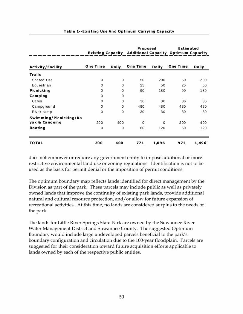
50
Activity/Facility One T im e Daily O ne Time Daily One Time Daily
Tra ils Sha red Use 0 0 50 200 50 200 Eques trian 0 0 25 50 25 50Pic nicking 0 0 90 180 90 180Camping 0 0 Cabin 0 0 36 36 36 36 Campground 0 0 480 480 480 480 R ive r camp 0 0 30 30 30 30
Swimm ing/Pic nicking/Kayak & Ca no eing 200 400 0 0 200 400Bo ating 0 0 60 120 60 120
TO TAL 200 400 771 1,096 971 1,496
Proposed Additio nal Ca pacityE xisting Capac ity
E stim ated Optim um Capacity
T able 1--E xis ting Us e And Optimum Carrying Capacity
does not empower or require any government entity to impose additional or more restrictive environmental land use or zoning regulations. Identification is not to be used as the basis for permit denial or the imposition of permit conditions. The optimum boundary map reflects lands identified for direct management by the Division as part of the park. These parcels may include public as well as privately owned lands that improve the continuity of existing park lands, provide additional natural and cultural resource protection, and/or allow for future expansion of recreational activities. At this time, no lands are considered surplus to the needs of the park. The lands for Little River Springs State Park are owned by the Suwannee River Water Management District and Suwannee County. The suggested Optimum Boundary would include large undeveloped parcels beneficial to the park’s boundary configuration and circulation due to the 100-year floodplain. Parcels are suggested for their consideration toward future acquisition efforts applicable to lands owned by each of the respective public entities.

LITTLE RIVER SPRINGSSTATE PARK Florida Department of Environmental Protection
Division of Recreation and ParksOffice of Park Planning
´0 1,500 3,000750
Feet
OPTIMUM BOUNDARY MAP
LEGENDPark BoundaryOptimum Boundary

52

Addendum 1—References Cited

Little River Springs State Park References Cited
A 1 - 1
Berndt M. P., H.H. Hatzell, C.A. Crandall, M.Tutora, J.R. Pittman, E. T. Oaksford. 1998. Water Quality in the Georgia-Florida Coastal Plain, Georgia, and Florida, 1992-96. A contribution of the National Water Quality Assessment (NWQA) Program.
Bureau of Economic and Business Research (BEBR), University of Florida. 2002.
Florida Statistical Abstract 2002. Gainesville, Florida. Bureau of Economic and Business Research (BEBR), University of Florida. 2006.
Florida Statistical Abstract 2006. Gainesville, Florida. Copeland, R., S. Upchurch, K. Summers, T. Janicki, P. Hansard, M. Paulic, G.
Maddox, J. Silvanima, P. Craig. 1999. Overview of the Florida Department of Environmental Protection’s Integrated Water Resource Monitoring Efforts and the Design Plan of the Status Network. Florida Department of Environmental Protection. 43pp.
Crane, J.J. 1986. An Investigation of the Geology, Hydrogeology, and
Hydrochemistry of the Lower Suwannee River Basin, Report of Investigation No. 96, Bureau of Geology, Division of Resource Management, Florida Department of Natural Resources, Tallahassee. 205 pp.
Fernald E. A., and E.D. Purdum 1998. Water Resources Atlas of Florida. Florida State
University, Institute of Science and Public Affairs. Florida Geological Survey. 1991. Florida's Ground Water Quality Monitoring
Program, Hydrogeological Framework, edited by T.M. Scott, J.M. Lloyd, and G.L. Maddox. 97 pp.
Florida Department Environmental Protection, 2001. Basin Status Report for the
Suwannee River (including Aucilla, Coastal, Suwannee and Waccasassa Basins in Florida). Technical Report 193pp
Florida Department Environmental Protection, 2005. Elements of Florida’s Water
Monitoring and Assessment Program. Technical Report 113pp. Florida Natural Areas Inventory and the Florida Department of Natural Resources,
1990. Guide to the Natural Communities of Florida. Tallahassee, FL. 111 pp. Ham, L.K., and H. H. Hatzell. 1996. Analysis of Nutrients in the Surface Waters of the
Georgia-Florida Coastal Plain Study Unit, 1970-91: U.S. Geological Survey Water-Resources Investigations Report 96-4037. 67pp.

Little River Springs State Park References Cited
A 1 - 2
Hand, J., J. Col and L. Lord. 1996. 1996 Water Quality Assessment for the State of Florida Technical Appendix Northeast Florida. Bureau of Surface Water Management, Florida Department of Environmental Protection, 95 pp.
Hendryx, G. S. 2002. An Intensive Cultural Resource Assessment Survey of a
Proposed Parking Area at Little River Springs, Suwannee County, Florida. An Addendum to: An Intensive Cultural Resource Assessment Survey of Proposed Impacts at Little River Springs, Suwannee County, Florida. Environmental Services, Inc. Report of Investigations No. 331A EJ02334.01 For Suwannee River Water Management District. Dec, 2002.
Hornsby D. and R. Ceryak. 1998. Springs of the Suwannee River Basin in Florida.
Suwannee River Water Management District Technical Report WR-99-02. 178 pp.
Hornsby, D., R. Mattson, and T. Mirti. 1999. Surfacewater Quality and Biological
Annual Report 1999. Suwannee River Water Management District Technical Report WR-00-04. 152 pp.
Hornsby, D., R. Mattson, and T. Mirti. 2001. Surfacewater Quality and Biological
Annual Report 2001. Suwannee River Water Management District Technical Report WR-01-02-04. 14 pp.
Hornsby, D., R. Mattson, and T. Mirti. 2002. Surfacewater Quality and Biological
Annual Report 2002. Suwannee River Water Management District Technical Report WR-02-03. 42 pp.
Johnson, K. W., Nelson, B. C., and K. A. Terry. 1988. The Search for Early Spanish-
Indian Sites in North Florida. Archeological Survey of Portions of Columbia, Suwannee, Union and Adjacent Counties. Season II. Miscellaneous Project Report Number 38, Depart. Anthropology, FL Museum of Natural History, Gainesville, FL. Oct 31, 1988.
Katz, B., D. Hornsby, J. F. Bohlke, and M. F. Mokray. 1999. Sources and Chronology
of Nitrate Contamination in Spring Waters, Suwannee River Basin, Florida. U.S. Geological Survey Water-Resources Investigations Report 99-4252. 54pp.
Katz B. D. and D. Hornsby. 1998. A Preliminary Assessment of Sources of Nitrate in
Springwaters, Suwannee River Basin, Florida. U.S. Geological Survey Open-File Report 98-69. 23pp.

Little River Springs State Park References Cited
A 1 - 3
Kenner, S.J., S. Singh, K. Coates, W.C. Huber, J.P. Heany. 1991. Review and Development of Water Quality Criteria for the Suwannee River. Interim Report to SRWMD. Contract 89/90-93. 243pp.
Pittman, J. R. H. H. Hatzell, and E. T. Oaksford. 1997. Spring Contributions to Water
Quantity and Nitrate Loads in the Suwannee River during Base Flow in July 1995. U.S. Geological Survey Water-Resources Investigations Report 97-4152. 12pp.
Scott, T.M., G.H. Means, R.P.Meegan, R.C. Means, S.B. Upchurch, R.E. Copeland, J.
Jones, T. Roberts, and A. Willet. 2004. Springs of Florida. Florida Geological Survey Bulletin No. 66. 377pp.
Sepulveda, N. 2002. Simulation of Ground-Water Flow in the Intermediate and
Floridan Aquifer Systems in Peninsular Florida. U.S. Geological Survey Water-Resources Investigations Report 02-4009. 138pp.
Skiles, W. 2007. Personal Communication. Suwannee River Hydrologic Observatory. 1997. The Suwannee River: A Coastal
Plain Watershed in Transition. A prospectus from the website http://suwanneeho.ifas.ufl.edu/ .
Suwannee River Water Management District (SRWMD) 2005. Minimum Flows and
Levels Establishment for Lower Suwannee River, & Estuary, Fanning and Manatee Springs. Final Technical Report October 2005.
Weatherspoon, R.L. 2006. Soil Survey of Suwannee County, Florida. USDA, NRCS. 435pp. White, W. A. 1970. The geomorphology of the Florida peninsula. Fla. Bur. Geol.
Bull. No. 51.

Little River Springs State Park References Cited
A 1 - 4

Addendum 2—Soils Descriptions

Little River Springs State Park Soils Descriptions
A 2 - 1
(7) Bigbee-Garcon-Meggett complex, occasionally flooded - This soil complex is composed of Bigbee and similar soils (40 percent), Garcon and similar soils (30 percent), and Meggett and similar soils (20 percent). Also included in this mapping unit are smaller areas of Chipley soils (5 percent) and Blanton soils (5 percent). The Bigbee component is present on stream terraces on marine terraces of the North Central Florida Ridge. The soil originates from sandy marine sediments. This soil occurs on a 0 to 2 percent slope. Typically, the surface layer is brown fine sand to a depth of 9 inches. The substratum, to a depth of 20 inches is yellowish brown fine sand; 20 to 36 inches is brownish yellow fine sand; 36 to 55 inches is brown fine sand; and 55 to 80 inches is light gray sand. This soil is excessively drained with rapid permeability. The depth of seasonal water saturation is 42 to 72 inches. This soil is occasionally flooded and does not pond. The available water capacity is very low. The Garcon component is present on rises on marine terraces of the North Central Florida Ridge. The soil originates from sandy and loamy marine sediments. This soil occurs on a 0 to 2 percent slope. Typically, the surface layer is dark gray fine sand to a depth of 7 inches. The upper part of the subsurface layer, which extends to 19 inches, is brown fine sand and from 19 to 26 inches is very pale brown fine sand. The subsoil from 26 to 40 inches is brownish yellow sandy clay loam that has strong brown and light brownish gray mottles; 40 to 51 inches is light brownish gray sandy loam that has brownish yellow mottles; 51 to 60 inches is very pale brown loamy fine sand that has brownish yellow mottles. The substratum from 60 to 80 inches is very pale brown fine sand that has light gray mottles. This soil is somewhat poorly drained with moderate permeability. The depth of seasonal water saturation is 18 to 36 inches. This soil is occasionally flooded and does not pond. The available water capacity is low. The Meggett component is present on depressions on flood plains on marine terraces of the North Central Florida Ridge. The soil originates from clayey marine and fluvial sediments on a 0 to 2 percent slope. Typically, the surface layer is very dark brown fine sand to a depth of 4 inches. The subsurface, to 11 inches is light brownish gray fine sand that has brown, pale brown, and grayish brown mottles. The subsoil, which extends to 31 inches is light brownish gray sandy clay that has red and strong brown mottles; 31 to 40 inches is mottled yellowish brown and gray sandy clay; and 40 to 80 inches is light gray sandy clay loam that has brownish yellow mottles. This soil is poorly drained with slow permeability. The depth of seasonal water saturation is 0 to 12 inches. This soil occasionally floods and ponds. The available water capacity is high.
Little River Springs State Park Soils Descriptions
A 2 - 2
(10) Blanton-Alpin complex, 0 to 5 percent slopes, occasionally flooded - This soil complex is composed of Blanton and similar soils (45 percent) and Alpin and similar soils (38 percent). Also included in this mapping unit are smaller areas of Chipley soils (7 percent), Albany soils (5 percent), and Foxworth soils (5 percent). The Blanton component is present on ridges on stream terraces on marine terraces of the North Central Florida Ridge. The soil originates from sandy and loamy marine sediments. This soil occurs on a 0 to 5 percent slope. Typically, the surface layer is dark gray fine sand to a depth of 5 inches. The subsurface layer, to a depth of 13 inches is light olive brown fine sand; 13 to 27 inches is light yellowish brown fine sand; 27 to 36 inches is pale yellow fine sand; and 36 to 41 inches; light gray fine sand. The subsoil to a depth of 48 inches is pale brown sandy loam that has light brownish gray mottles; 48 to 67 inches is mottled yellowish red, yellowish brown, and light brownish gray sandy clay loam; 67 to 74 inches is gray sandy clay loam that has yellowish brown and light olive brown mottles; and 74 to 80 inches is gray sandy clay loam that has red mottles. The soil is moderately well drained with moderately slow permeability. The depth of seasonal water saturation is 42 to 72 inches. This soil is occasionally flooded and does not pond. The available water capacity is very low. The Alpin component is present on ridges on stream terraces on marine terraces of the North Central Florida Ridge. The soil originates from sandy marine deposits. This soil occurs on a 0 to 5 percent slope. Typically, the surface layer is grayish brown fine sand to a depth of 6 inches. The subsurface layer, from 6 to 20 inches is brown fine sand; 20 to 44 inches is yellow fine sand that has very pale brown stripping; and 44 to 65 inches is light yellowish brown fine sand that has very dark grayish brown mottles. The subsoil, which extends to a depth of 80 inches is stratified very pale brown fine sand and yellowish brown loamy fine sand. This soil is excessively drained with moderately rapid permeability. The depth of seasonal water saturation is more than 6 feet. This soil is occasionally flooded and does not pond. The available water capacity is very low. (11) Bonneau-Blanton-Padlock complex, 0 to 5 percent slopes - This soil complex is composed of Bonneau and similar soils (40 percent), Blanton and similar soils (30 percent), and Padlock and similar soils (20 percent). Also included in this mapping unit are smaller areas of Alpin soils (5 percent) and Chiplay soils (5 percent). The Bonneau component is present on ridges on marine terraces of the North Central Florida Ridge. The soil originates from marine sediments. This soil occurs on a 0 to 5 percent slope. Typically, the surface layer is grayish brown fine sand to a depth of 7 inches. The subsurface layer from 7 to 15 inches is yellowish brown fine sand that has light yellowish brown stripping; and from 15 to 27 inches is brownish yellow fine sand.
Little River Springs State Park Soils Descriptions
A 2 - 3
The subsoil from 27 to 36 inches is yellowish brown fine sandy loam; 36 to 58 inches is mottled grayish brown, yellowish red, very pale brown, pale brown, and strong brown sandy clay loam; 58 to 74 inches is mottled grayish brown, gray, and very pale brown sandy clay loam; and 74 to 80 inches is mottled gray and pink sandy clay loam. This soil is well drained with moderate permeability. The depth of seasonal water saturation is 42 to 60 inches. This soil does not flood or pond. The available water capacity is low. The Blanton component is present on ridges on marine terraces of the North Central Florida Ridge. The soil originates from sandy and loamy marine sediments. This soil occurs on a 0 to 5 percent slope. Typically, the surface layer is dark gray fine sand to a depth of 5 inches. The subsurface layer, from 5 to 13 inches is light olive brown fine sand; 13 to 27 inches is light yellowish brown fine sand; 27 to 36 inches is pale yellow fine sand; and 36 to 41 inches is light gray fine sand. The subsoil, from 41 to 48 inches is pale brown sandy loam that has light brownish gray mottles; 48 to 67 inches is mottled yellowish red, yellowish brown, and light brownish gray sandy clay loam; 67 to 74 inches is gray sandy clay loam that has yellowish brown and light olive brown mottles; and 74 to 80 inches is gray sandy clay loam that has red mottles. This soil is moderately well drained with moderately slow permeability. The depth of seasonal water saturation is 42 to 72 inches. This soil does not flood or pond. The available water capacity is very low. The Padlock component is present on depressions on knolls on marine terraces of the North Central Florida Ridge. The soil originates from clayey marine deposits. This soil occurs on a 2 to 5 percent slope. Typically, the surface layer is very dark grayish brown fine sand to a depth of 5 inches. The subsoil, from 5 to 13 inches is yellowish red sandy clay; 13 to 17 inches is strong brown sandy clay that has dark yellowish brown and yellowish brown mottles; 17 to 22 inches is dark yellowish brown sandy clay that has yellowish brown and pale brown mottles; 22 to 51 inches is light brownish gray sandy clay that has strong brown, dark brown, and light gray mottles; 51 to 63 inches is light brownish gray sandy clay that has strong brown and dark brown mottles; and 63 to 80 inches is light gray sandy clay that has dark brown and strong brown mottles. This soil is moderately well drained with slow permeability. The depth of seasonal water saturation is 18 to 36 inches. This soil does not flood or pond. The available water capacity is high. (18) Otela-Chiefland-Ichetucknee complex, 0 to 5 percent slopes - This soil complex is composed of Otela and similar soils (42 percent), Chiefland and similar soils (30 percent), and Ichetucknee and similar soils (18 percent). Also included in this mapping unit are smaller areas of Pedro Variant soils (5 percent) and Blanton soils (5 percent).
Little River Springs State Park Soils Descriptions
A 2 - 4
The Otela component is present on rises on marine terraces of the North Central Florida Ridge. The soil originates from sandy and loamy marine sediments over limestone. This soil occurs on a 0 to 5 percent slope. Typically, the surface layer is dark grayish brown fine sand to a depth of 6 inches. The subsurface layer, from 6 to 21 inches is brown fine sand; 21 to 31 inches is pale brown fine sand that has dark brown and brownish yellow mottles; 31 to 40 inches is very pale brown fine sand that has dark brown mottles; and 40 to 60 inches is yellowish brown fine sand. The subsoil, from 60 to 65 inches is yellowish brown sandy loam that has dark brown mottles; 65 to 75 inches is yellowish brown sandy loam that has white and dark brown mottles; 75 to 80 inches is light gray sandy clay loam that has yellowish brown mottles. This soil is moderately well drained with slow permeability. The depth of seasonal water saturation is 48 to 72 inches. This soil does not flood or pond. The available water capacity is low. The Chiefland component is present on ridges on knolls on karst marine terraces of the North Central Florida Ridge. The soil originates from sandy and loamy marine deposits over limestone. This soil occurs on a 0 to 5 percent slope. Typically, the surface layer is brown fine sand to a depth of 8 inches. The subsurface layer, to a depth of 33 inches, is pale brown fine sand that has brownish yellow and brown splotches and streaks. The subsoil, extending to a depth of 39 inches, is strong brown fine sandy loam. The substratum, from 39 to 80 inches is very pale brown, soft limestone bedrock. This soil is moderately well drained with moderate permeability. The depth of seasonal water saturation is more than 6 feet. This soil does not flood or pond. The available water capacity is very low. The Ichetucknee component is present on depressions knolls on karst marine terraces of the North Central Florida Ridge. The soil originates from sandy and clayey marine deposits over limestone. This soil occurs on a 0 to 5 percent slope. Typically, the surface layer is gray fine sand to a depth of 5 inches. The subsurface layer is light gray fine sand to a depth of 13 inches. The subsoil, from 13 to 39 inches is pale brown clay that has gray, brownish yellow, and red mottles; and 39 to 55 inches is yellowish red clay. The substratum is very pale brown, soft and hard limestone to a depth of 80 inches. This soil is somewhat poorly drained with very slow permeability. The depth of seasonal water saturation is 18 to 36 inches. This soil does not flood or pond. The available water capacity is high. (19) Chiefland fine sand, occasionally flooded - This soil is composed of Chiefland and similar soils (85 percent). Also included in this mapping unit are smaller areas of Otela

Little River Springs State Park Soils Descriptions
A 2 - 5
soils (10 percent) and Ichetucknee soils (5 percent). The Chiefland fine sand is present on knolls on karst marine terraces of the North Central Florida Ridge. The soil originates from sandy and loamy marine deposits over limestone. This soil occurs on a 0 to 2 percent slope. Typically, the surface layer is brown fine sand to a depth of 8 inches. The subsurface layer is pale brown fine sand that has brownish yellow and brown splotches and streaks to a depth of 33 inches. The subsoil is strong brown fine sandy loam to a depth of 39 inches. The substratum is very pale brown, soft limestone bedrock extending to a depth of 80 inches. This soil is moderately well drained with moderate permeability. The depth of seasonal water saturation is more than 6 feet. This soil is occasionally flooded and does not pond. The available water capacity is very low. (41) Fluvaquents-Meggett-Bigbee complex, frequently flooded - This soil complex is composed of Fluvaquents and similar soils (40 percent), Meggett and similar soils (30 percent), and Bigbee and similar soils (20 percent). Also included in this mapping unit are smaller areas of Chipley soils (5 percent) and Blanton soils (5 percent). The Fluvaquents component is present on Depressions on flood plains on marine terraces of the North Central Florida Ridge. The soil originates from marine deposits and alluvium. This soil occurs on a 0 to 2 percent slope. Typically, the surface layer is very dark brown mucky fine sand to a depth of 6 inches. The subsurface layer is light brownish gray sandy clay loam to a depth of 11 inches. The subsoil, to 31 inches is light brownish gray fine sand and to 40 inches is mottled gray and yellowish brown sandy clay loam. The substratum is white sandy clay loam to a depth of 80 inches. This soil is poorly drained with unreported permeability. The depth of seasonal water saturation is 0 to 6 inches. This soil frequently floods and ponds. The available water capacity is not rated. The Meggett component is present on depressions on flood plains on marine terraces of the North Central Florida Ridge. The soil originates from clayey marine and fluvial sediments. This soil occurs on a 0 to 2 percent slope. Typically, the surface layer is very dark brown fine sand to a depth of 4 inches. The subsurface, to 11 inches is light brownish gray fine sand that has brown, pale brown, and grayish brown mottles. The subsoil, from 11 to 31 inches is light brownish gray sandy clay that has red and strong brown mottles; 31 to 40 inches is mottled yellowish brown and gray sandy clay; and 40 to 80 inches is light gray sandy clay loam that has brownish yellow mottles. This soil is poorly drained with slow permeability. The depth of seasonal water saturation is 0 to 12 inches. This soil is frequently floods and ponds. The available water capacity is low.
Little River Springs State Park Soils Descriptions
A 2 - 6
The Bigbee component is present on stream terraces on marine terraces of the North Central Florida Ridge. The soil originates from sandy marine sediments. This soil occurs on a 0 to 2 percent slope. Typically, the surface layer is brown fine sand to a depth of 9 inches. The substratum, to a depth of 20 inches is yellowish brown fine sand; 20 to 36 inches is brownish yellow fine sand; 36 to 55 inches is brown fine sand; and 55 to 80 inches is light gray sand. This soil is excessively drained with rapid permeability. The depth of seasonal water saturation is 42 to 72 inches. This soil is occasionally flooded and does not pond. The available water capacity is very low. (71) Otela-Alpin-Chiefland complex, 0 to 5 percent slopes - This soil complex is composed of Otela and similar soils (42 percent), Alpin and similar soils (35 percent), and Chiefland and similar soils (20 percent). Also included in this mapping unit are smaller areas of Albany soils (3 percent). The Otela component is present on knolls on marine terraces of the North Central Florida Ridge. The soil originates from sandy and loamy marine sediments over limestone. This soil occurs on a 0 to 5 percent slope. Typically, the surface layer is dark grayish brown fine sand to a depth of 6 inches. The subsurface layer, from 6 to 21 inches is brown fine sand; 21 to 31 inches is pale brown fine sand that has dark brown and brownish yellow mottles; 31 to 40 inches is very pale brown fine sand that has dark brown mottles; and 40 to 60 inches is yellowish brown fine sand. The subsoil, from 60 to 65 inches is yellowish brown sandy loam that has dark brown mottles; 65 to 75 inches is yellowish brown sandy loam that has white and dark brown mottles; 75 to 80 inches is light gray sandy clay loam that has yellowish brown mottles. This soil is moderately well drained with slow permeability. The depth of seasonal water saturation is 48 to 72 inches. This soil does not flood or pond. The available water capacity is low. The Alpin component is present on ridges on marine terraces of the North Central Florida Ridge. The soil originates from sandy marine deposits. This soil occurs on a 0 to 5 percent slope. Typically, the surface layer is grayish brown fine sand to a depth of 6 inches. The subsurface layer, from 6 to 20 inches is brown fine sand; 20 to 44 inches is yellow fine sand that has very pale brown stripping; and 44 to 65 inches is light yellowish brown fine sand that has very dark grayish brown mottles. The subsoil, which extends to a depth of 80 inches, is stratified very pale brown fine sand and yellowish brown loamy fine sand. This soil is excessively drained with moderately rapid permeability. The depth of seasonal water saturation is more than 6 feet. This soil does not flood or pond. The
Little River Springs State Park Soils Descriptions
A 2 - 7
available water capacity is very low. The Chiefland component is present on ridges on karst marine terraces of the North Central Florida Ridge. The soil originates from sandy and loamy marine deposits over limestone. This soil occurs on a 0 to 5 percent slope. Typically, the surface layer is brown fine sand to a depth of 8 inches. The subsurface layer, to a depth of 33 inches, is pale brown fine sand that has brownish yellow and brown splotches and streaks. The subsoil, from 33 to 39 inches is strong brown fine sandy loam. The substratum, from 39 to 80 inches is very pale brown, soft limestone bedrock. This soil is moderately well drained with moderate permeability. The depth of seasonal water saturation is more than 6 feet. This soil does not flood or pond. The available water capacity is very low. (74) Surrency, Plummer, and Cantey soils, frequently flooded - This soil complex is composed of Surrency and similar soils (35 percent), Plummer and similar soils (30 percent), and Cantey and similar soils (25 percent). Also included in this mapping unit are smaller areas of Fluvaquents (5 percent) and Osier soils (5 percent). The Surrency component is present on flats on flood plains on marine terraces of the North Central Florida Ridge. The soil originates from marine and fluvial sediments. This soil occurs on a 0 to 1 percent slope. Typically, the surface layer is black fine sand to a depth of 8 inches and very dark gray fine sand from 8 to 16 inches. The subsurface layer, to a depth of 38 inches, is gray fine sand. The subsoil, to a depth of 80 inches, is grayish brown sandy clay loam that has white sand coatings and yellowish brown mottles. This soil is very poorly drained with moderately slow permeability. The depth of seasonal water saturation is 0 to 6 inches. This soil frequently floods and ponds. The available water capacity is low. The Plummer component is present on flats on flood plains on marine terraces of the North Central Florida Ridge. The soil originates from sandy and loamy marine deposits. This soil occurs on a 0 to 1 percent slope. Typically, the surface layer is black fine sand to a depth of 7 inches. The subsurface layer, from 7 to 14 inches is grayish brown fine sand; 14 to 22 inches is gray fine sand; and 22 to 55 inches is light gray fine sand that has yellowish brown mottles. The subsoil, which extends to a depth of 80 inches, is gray sandy clay loam that has yellowish brown mottles and white coatings. This soil is poorly drained with moderate permeability. The depth of seasonal water saturation is 0 to 12 inches. This soil frequently floods and ponds. The available water capacity is low.

Little River Springs State Park Soils Descriptions
A 2 - 8
The Cantey component is present on flats on flood plains on marine terraces of the North Central Florida Ridge. The soil originates from unconsolidated clayey sediments. This soil occurs on a 0 to 1 percent slope. Typically, the surface layer is very dark gray and gray sandy loam to a depth of 9 inches. The subsurface layer, which extends to a depth of 19 inches, is light brownish gray sandy loam that has strong brown and gray mottles. The subsoil, from 19 to 26 inches is light brownish gray sandy clay that has strong brown mottles; 26 to 37 inches is gray sandy clay that has red and yellowish brown mottles; and 37 to 80 inches is gray sandy clay that has brownish yellow, strong brown, and light brownish gray mottles. This soil is poorly drained with slow permeability. The depth of seasonal water saturation is 0 to 12 inches. This soil frequently floods and ponds. The available water capacity is high.

Addendum 3—Plant And Animal List

Little River Springs State Park Plants
Primary Habitat Codes Common Name Scientific Name (for designated species)
* Non-native Species A 3 - 1
PTERIDOPHYTES
Ebony spleenwort ...........................Asplenium platyneron ................................................... Japanese climbing fern *.................Lygodium japonicum ..................................................... Royal fern .........................................Osmunda regalis var. spectabilis ..................................
GYMNOSPERMS
Red cedar..........................................Juniperus virginiana ...................................................... Slash pine .........................................Pinus elliottii ................................................................. Longleaf pine ...................................Pinus palustris............................................................... Loblolly pine ....................................Pinus taeda..................................................................... Bald-cypress .....................................Taxodium distichum ......................................................
ANGIOSPERMS
Monocots Wiregrass..........................................Aristida stricta var. beyrichiana ................................... White yam * .....................................Dioscorea alata ............................................................... Bahiagrass *......................................Paspalum notatum......................................................... Bluestem palm .................................Sabal minor .................................................................... Cabbage palm .................................Sabal palmetto................................................................ Saw palmetto ...................................Serenoa repens ............................................................... Saw greenbrier ................................Smilax bona-nox ............................................................ Cat greenbrier ..................................Smilax glauca................................................................. Spanish moss ...................................Tillandsia usneoides....................................................... Adam's needle .................................Yucca filamentosa .......................................................... Atamasco lily ...................................Zephyranthes atamasca..........................................29, 31, 33
Dicots Red maple .......................................Acer rubrum .................................................................. Mimosa *...........................................Albizia julibrissin .......................................................... False indigobush .............................Amorpha fruticosa ......................................................... Peppervine .......................................Ampelopsis arborea ........................................................ Eastern bluestar ...............................Amsonia tabernaemontana ............................................ Devil's walkingstick........................Aralia spinosa ................................................................ Swamp milkweed ...........................Asclepias perennis.......................................................... Butterflyweed ..................................Asclepias tuberosa.......................................................... Slimleaf pawpaw.............................Asimina angustifolia...................................................... Woolly pawpaw ..............................Asimina incana .............................................................. White wild indigo ...........................Baptisia alba ...................................................................
Little River Springs State Park Plants
Primary Habitat Codes Common Name Scientific Name (for designated species)
* Non-native Species A 3 - 2
River birch........................................Betula nigra ................................................................... Crossvine .........................................Bignonia capreolata........................................................ Paper mulberry * .............................Broussonetia papyrifera ................................................. American beautyberry....................Callicarpa americana ..................................................... Trumpet creeper..............................Campsis radicans ........................................................... American hornbeam .......................Carpinus caroliniana ..................................................... Water hickory .................................Carya aquatica ............................................................... Pignut hickory ................................Carya glabra................................................................... Spadeleaf ..........................................Centella asiatica ............................................................. common buttonbush ......................Cephalanthus occidentalis ............................................. White fringetree...............................Chionanthus virginicus ................................................. Camphortree * .................................Cinnamomum camphora................................................ Tread-softly......................................Cnidoscolus stimulosus ................................................. Flowering dogwood .......................Cornus florida ................................................................ Parsley hawthorn ............................Crataegus marshallii ...................................................... Titi .....................................................Cyrilla racemiflora ......................................................... Common persimmon......................Diospyros virginiana ..................................................... Yankeeweed.....................................Eupatorium compositifolium ......................................... Eastern swampprivet......................Forestiera acuminata...................................................... Pop ash ............................................Fraxinus caroliniana...................................................... Yellow jessamine.............................Gelsemium sempervirens ............................................... Water locust .....................................Gleditsia aquatica........................................................... St. Andrew's-cross...........................Hypericum hypericoides ................................................ Possumhaw......................................Ilex decidua .................................................................... American holly ...............................Ilex opaca........................................................................ Hairy indigo * ..................................Indigofera hirsuta .......................................................... Glossy privet * .................................Ligustrum lucidum........................................................ Sweetgum ........................................Liquidambar styraciflua................................................. Coral honeysuckle...........................Lonicera sempervirens ................................................... Southern magnolia .........................Magnolia grandiflora ..................................................... Angle pod.........................................Matelea gonocarpos.................................................... 9, 33 Chinaberry *.....................................Melia azedarach ............................................................. Wax myrtle ......................................Myrica cerifera............................................................... Heavenly bamboo * ........................Nandina domestica ........................................................ Blackgum..........................................Nyssa sylvatica .............................................................. Virginia creeper ..............................Parthenocissus quinquefolia .......................................... American pokeweed.......................Phytolacca americana..................................................... Waterelm ..........................................Planera aquatica............................................................. Chicasaw plum................................Prunus angustifolia ....................................................... Carolina laurelcherry......................Prunus caroliniana ........................................................ Black cherry ....................................Prunus serotina .............................................................
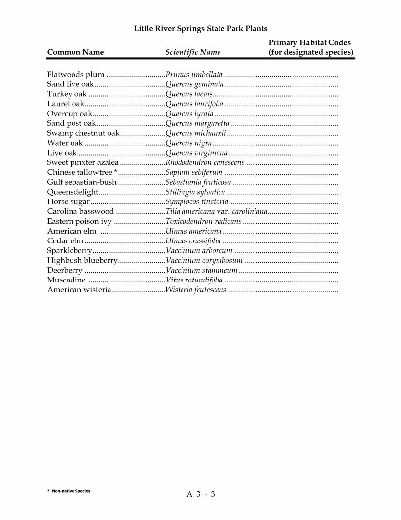
Little River Springs State Park Plants
Primary Habitat Codes Common Name Scientific Name (for designated species)
* Non-native Species A 3 - 3
Flatwoods plum ..............................Prunus umbellata .......................................................... Sand live oak....................................Quercus geminata.......................................................... Turkey oak .......................................Quercus laevis................................................................ Laurel oak.........................................Quercus laurifolia .......................................................... Overcup oak.....................................Quercus lyrata ............................................................... Sand post oak...................................Quercus margaretta ....................................................... Swamp chestnut oak.......................Quercus michauxii......................................................... Water oak .........................................Quercus nigra ................................................................ Live oak ............................................Quercus virginiana........................................................ Sweet pinxter azalea .......................Rhododendron canescens ............................................... Chinese tallowtree * ........................Sapium sebiferum .......................................................... Gulf sebastian-bush ........................Sebastiania fruticosa ...................................................... Queensdelight..................................Stillingia sylvatica ......................................................... Horse sugar......................................Symplocos tinctoria ....................................................... Carolina basswood .........................Tilia americana var. caroliniana.................................... Eastern poison ivy ..........................Toxicodendron radicans................................................. American elm .................................Ulmus americana ........................................................... Cedar elm .........................................Ulmus crassifolia ........................................................... Sparkleberry.....................................Vaccinium arboreum ..................................................... Highbush blueberry........................Vaccinium corymbosum ................................................ Deerberry .........................................Vaccinium stamineum................................................... Muscadine .......................................Vitus rotundifolia .......................................................... American wisteria ...........................Wisteria frutescens ........................................................

Little River Springs State Park Plants
Primary Habitat Codes Common Name Scientific Name (for designated species)
* Non-native Species A 3 - 4

Little River Springs State Park Animals
Primary Habitat Codes Common Name Scientific Name (for all species)
* Non-native Species A 3 - 5
INVERTEBRATES
Horace's skipper..............................Erynnis horatius .......................................................MTC Sleepy orange...................................Eurema nicippe ..........................................................MTC Common buckeye ...........................Junonia coenia............................................................MTC Eastern tiger swallowtail................Papilio glaucus ..........................................................MTC Cloudless sulphur ...........................Phoebis sennae ...........................................................MTC American lady .................................Vanessa virginiensis ..................................................MTC
FISH
Gulf sturgeon ....................................Acipenser oxyrinchus desotoi ........................................ 55
AMPHIBIANS
Southern toad ..................................Bufo terrestris ............................................................MTC Green treefrog..................................Hyla cinerea ..............................................................MTC Southern leopard frog ....................Rana sphenocephala ...............................................31, 33, 50
REPTILES
Crocodilians American alligator ..........................Alligator mississippiensis ............................................ 55 Turtles Gopher tortoise................................Gopherus polyphemus ................................. 14, 23, Pasture Alligator snapping turtle ...............Macrochelys temminckii .............................................. 55 Suwannee cooter .............................Pseudemys concinna suwanniensis ............................. 55 Yellow-bellied slider.......................Trachemys scripta scripta ............................................ 55 Lizards Green anole ......................................Anolis carolinensis ....................................................MTC Six-lined racerunner ......................Cnemidophorus sexlineatus ......................................... 14 Broad-head skink ............................Eumeces laticeps ....................................................18, 22, 29 Ground skink...................................Scincella lateralis ...................................................18, 22, 29
BIRDS
Ducks and Geese Wood Duck ......................................Aix sponsa................................................................. 50, 55

Little River Springs State Park Animals
Primary Habitat Codes Common Name Scientific Name (for all species)
* Non-native Species A 3 - 6
Vultures Turkey Vulture ................................Cathartes aura ...........................................................MTC Black Vulture ...................................Coragyps atratus........................................................MTC
Accipiters Red-tailed Hawk .............................Buteo jamaicensis .............................................. 14, Pasture Red-shouldered Hawk ...................Buteo lineatus ............................................................MTC
Doves Mourning Dove ...............................Zenaida macroura ............................................. 84, Pasture
Owls Barred Owl.......................................Strix varia ..............................................................29, 33, 35
Kingfishers Belted Kingfisher.............................Ceryle alcyon................................................................ 55
Woodpeckers Common Flicker..............................Colaptes auratus ......................................................Pasture Pileated Woodpecker......................Dryocopus pileatus .................................................. 22, 23 Red-bellied Woodpecker................Melanerpes carolinus ................................................MTC
Flycatchers and Kingbirds Great Crested Flycatcher................Myiarchus crinitus ....................................................MTC Acadian Flycatcher .........................Empidonax virescens ............................................29, 33, 35 Eastern Phoebe ................................Sayornis phoebe............................................ 14, 23, Pasture
Vireos Red-eyed Vireo................................Vireo olivaceus .......................................................22, 29, 33
Corvids American Crow ...............................Corvus brachyrhynchos .............................................MTC Blue jay .............................................Cyanocitta cristata ....................................................MTC
Parids Tufted Titmouse ..............................Baeolophus bicolor .....................................................MTC
Wrens Carolina Wren .................................Thryothorus ludovicianus..........................................MTC
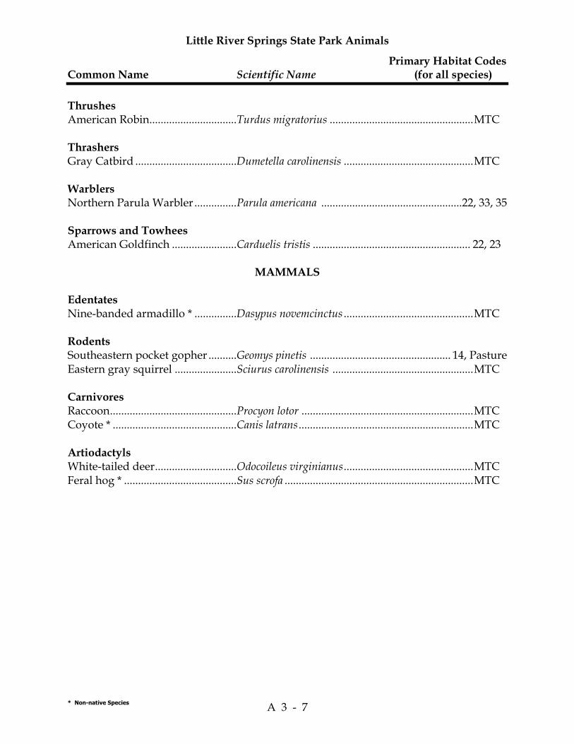
Little River Springs State Park Animals
Primary Habitat Codes Common Name Scientific Name (for all species)
* Non-native Species A 3 - 7
Thrushes American Robin...............................Turdus migratorius ...................................................MTC
Thrashers Gray Catbird ....................................Dumetella carolinensis ..............................................MTC
Warblers Northern Parula Warbler ...............Parula americana ..................................................22, 33, 35
Sparrows and Towhees American Goldfinch .......................Carduelis tristis ........................................................ 22, 23
MAMMALS
Edentates Nine-banded armadillo * ...............Dasypus novemcinctus ..............................................MTC
Rodents Southeastern pocket gopher ..........Geomys pinetis .................................................. 14, Pasture Eastern gray squirrel ......................Sciurus carolinensis ..................................................MTC
Carnivores Raccoon.............................................Procyon lotor .............................................................MTC Coyote * ............................................Canis latrans ..............................................................MTC
Artiodactyls White-tailed deer.............................Odocoileus virginianus..............................................MTC Feral hog * ........................................Sus scrofa ...................................................................MTC

Little River Springs State Park Animals
Primary Habitat Codes Common Name Scientific Name (for all species)
* Non-native Species A 3 - 8

Natural Community Habitat Codes
9
Terrestrial 1. Beach Dune 2. Bluff 3. Coastal Berm 4. Coastal Rock Barren 5. Coastal Strand 6. Dry Prairie 7. Maritime Hammock 8. Mesic Flatwoods 9. Mesic Hammock 10. Coastal Grasslands 11. Pine Rockland 12. Prairie Hammock 13. Rockland Hammock 14. Sandhill 15. Scrub 16. Scrubby Flatwoods 17. Shell Mound 18. Sinkhole 19. Slope Forest 20. Upland Glade 21. Upland Hardwood Forest 22. Upland Mixed Forest 23. Upland Pine Forest 24. Xeric Hammock Palustrine 25. Basin Marsh 26. Basin Swamp 27. Baygall 28. Bog 29. Bottomland Forest 30. Coastal Interdunal Swale 31. Depression Marsh 32. Dome 33. Floodplain Forest 34. Floodplain Marsh 35. Floodplain Swamp 36. Freshwater Tidal Swamp 37. Hydric Hammock 38. Marl Prairie 39. Seepage Slope 40. Slough 41. Strand Swamp 42. Swale 43. Wet Flatwoods 44. Wet Prairie
Lacustrine 45. Clastic Upland Lake 46. Coastal Dune Lake 47. Coastal Rockland Lake 48. Flatwood/Prairie Lake 49. Marsh Lake 50. River Floodplain Lake 51. Sandhill Upland Lake 52. Sinkhole Lake 53. Swamp Lake Riverine 54. Alluvial Stream 55. Blackwater Stream 56. Seepage Stream 57. Spring-Run Stream Estuarine 58. Estuarine Algal Bed 59. Estuarine Composite Substrate 60. Estuarine Consolidated Substrate 61. Estuarine Coral Reef 62. Estuarine Grass Bed 63. Estuarine Mollusk Reef 64. Estuarine Octocoral Bed 65. Estuarine Sponge Bed 66. Estuarine Tidal Marsh 67. Estuarine Tidal Swamp 68. Estuarine Unconsolidated Substrate 69. Estuarine Worm Reef Marine 70. Marine Algal Bed 71. Marine Composite Substrate 72. Marine Consolidated Substrate 73. Marine Coral Reef 74. Marine Grass Bed 75. Marine Mollusk Reef 76. Marine Octocoral Bed 77. Marine Sponge Bed 78. Marine Tidal Marsh 79. Marine Tidal Swamp 80. Marine Unconsolidated Substrate 81. Marine Worm Reef Subterranean 82. Aquatic Cave 83. Terrestral Cave Miscellaneous 84. Ruderal 85. Developed

Natural Community Habitat Codes
10

Addendum 4—Designated Species List


Rank Explanations For FNAI Global Rank,FNAI State Rank,Federal Status,And State Status
A 4 - 1
The Nature Conservancy and the Natural Heritage Program Network (of which FNAI is a part) define an element as any exemplary or rare component of the natural environment,such as a species,natural community,bird rookery,spring,sinkhole,cave,or other ecological feature. An element occurrence (EO) is a single extant habitat that sustains or otherwise contributes to the survival of a population or a distinct,self-sustaining example of a particular element. Using a ranking system developed by The Nature Conservancy and the Natural Heritage Program Network,the Florida Natural Areas Inventory assigns two ranks to each element. The global rank is based on an element's worldwide status; the state rank is based on the status of the element in Florida. Element ranks are based on many factors,the most important ones being estimated number of Element occurrences,estimated abundance (number of individuals for species; area for natural communities),range,estimated adequately protected EOs,relative threat of destruction,and ecological fragility. Federal and State status information is from the U.S. Fish and Wildlife Service; and the Florida Game and Freshwater Fish Commission (animals),and the Florida Department of Agriculture and Consumer Services (plants),respectively.
FNAI GLOBAL RANK DEFINITIONS G1 = Critically imperiled globally because of extreme rarity (5 or fewer occurrences or less than 1000
individuals) or because of extreme vulnerability to extinction due to some natural or man-made factor.
G2 = Imperiled globally because of rarity (6 to 20 occurrences or less than 3000 individuals) or because of vulnerability to extinction due to some natural or man-made factor.
G3 = Either very rare and local throughout its range (21-100 occurrences or less than 10,000 individuals) or found locally in a restricted range or vulnerable to extinction of other factors.
G4 = apparently secure globally (may be rare in parts of range) G5 = demonstrably secure globally GH = of historical occurrence throughout its range,may be rediscovered (e.g.,ivory-billed woodpecker) GX = believed to be extinct throughout range GXC = extirpated from the wild but still known from captivity or cultivation G#? = tentative rank (e.g.,G2?) G#G# = range of rank; insufficient data to assign specific global rank (e.g.,G2G3) G#T# = rank of a taxonomic subgroup such as a subspecies or variety; the G portion of the rank refers to
the entire species and the T portion refers to the specific subgroup; numbers have same definition as above (e.g.,G3T1)
G#Q = rank of questionable species - ranked as species but questionable whether it is species or subspecies; numbers have same definition as above (e.g.,G2Q)
G#T#Q = same as above,but validity as subspecies or variety is questioned. GU = due to lack of information,no rank or range can be assigned (e.g.,GUT2). G? = not yet ranked (temporary) S1 = Critically imperiled in Florida because of extreme rarity (5 or fewer occurrences or less than 1000
individuals) or because of extreme vulnerability to extinction due to some natural or man-made factor.
S2 = Imperiled in Florida because of rarity (6 to 20 occurrences or less than 3000 individuals) or because of vulnerability to extinction due to some natural or man-made factor.
S3 = Either very rare and local throughout its range (21-100 occurrences or less than 10,000 individuals) or found locally in a restricted range or vulnerable to extinction of other factors.
S4 = apparently secure in Florida (may be rare in parts of range) S5 = demonstrably secure in Florida SH = of historical occurrence throughout its range,may be rediscovered (e.g.,ivory-billed woodpecker) SX = believed to be extinct throughout range SA = accidental in Florida,i.e.,not part of the established biota SE = an exotic species established in Florida may be native elsewhere in North America SN = regularly occurring,but widely and unreliably distributed; sites for conservation hard to determine SU = due to lack of information,no rank or range can be assigned (e.g.,SUT2). S? = not yet ranked (temporary)
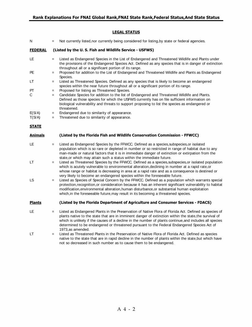
Rank Explanations For FNAI Global Rank,FNAI State Rank,Federal Status,And State Status
A 4 - 2
LEGAL STATUS N = Not currently listed,nor currently being considered for listing,by state or federal agencies. FEDERAL (Listed by the U. S. Fish and Wildlife Service - USFWS) LE = Listed as Endangered Species in the List of Endangered and Threatened Wildlife and Plants under
the provisions of the Endangered Species Act. Defined as any species that is in danger of extinction throughout all or a significant portion of its range.
PE = Proposed for addition to the List of Endangered and Threatened Wildlife and Plants as Endangered Species.
LT = Listed as Threatened Species. Defined as any species that is likely to become an endangered species within the near future throughout all or a significant portion of its range.
PT = Proposed for listing as Threatened Species. C = Candidate Species for addition to the list of Endangered and Threatened Wildlife and Plants.
Defined as those species for which the USFWS currently has on file sufficient information on biological vulnerability and threats to support proposing to list the species as endangered or threatened.
E(S/A) = Endangered due to similarity of appearance. T(S/A) = Threatened due to similarity of appearance. STATE Animals (Listed by the Florida Fish and Wildlife Conservation Commission - FFWCC) LE = Listed as Endangered Species by the FFWCC. Defined as a species,subspecies,or isolated
population which is so rare or depleted in number or so restricted in range of habitat due to any man-made or natural factors that it is in immediate danger of extinction or extirpation from the state,or which may attain such a status within the immediate future.
LT = Listed as Threatened Species by the FFWCC. Defined as a species,subspecies,or isolated population which is acutely vulnerable to environmental alteration,declining in number at a rapid rate,or whose range or habitat is decreasing in area at a rapid rate and as a consequence is destined or very likely to become an endangered species within the foreseeable future.
LS = Listed as Species of Special Concern by the FFWCC. Defined as a population which warrants special protection,recognition,or consideration because it has an inherent significant vulnerability to habitat modification,environmental alteration,human disturbance,or substantial human exploitation which,in the foreseeable future,may result in its becoming a threatened species.
Plants (Listed by the Florida Department of Agriculture and Consumer Services - FDACS) LE = Listed as Endangered Plants in the Preservation of Native Flora of Florida Act. Defined as species of
plants native to the state that are in imminent danger of extinction within the state,the survival of which is unlikely if the causes of a decline in the number of plants continue,and includes all species determined to be endangered or threatened pursuant to the Federal Endangered Species Act of 1973,as amended.
LT = Listed as Threatened Plants in the Preservation of Native Flora of Florida Act. Defined as species native to the state that are in rapid decline in the number of plants within the state,but which have not so decreased in such number as to cause them to be endangered.

Little River Springs State Park Designated Species—Plants
Common Name/ Designated Species Status Scientific Name FDACS USFWS FNAI
A 4 - 3
Angle pod Matelea gonocarpos LT LT Atamasco lily Zephyranthes atamasca LT LT

Little River Springs State Park Designated Species—Plants
Common Name/ Designated Species Status Scientific Name FDACS USFWS FNAI
A 4 - 4

Little River Springs State Park Designated Species—Animals
Common Name/ Designated Species Status Scientific Name FFWCC USFWS FNAI
A 4 - 5
FISH Gulf sturgeon Acipenser oxyrinchus desotoi LS LT G3T2, S2
REPTILES American alligator Alligator mississippiensis LS T(S/A) G5, S4 Gopher tortoise Gopherus polyphemus LT G3, S3 Alligator snapping turtle Macroclemys temminckii LS G3G4, S3 Suwannee cooter Pseudemys concinna suwanniensis LS G5T3, S3
BIRDS Cooper’s Hawk Accipiter cooperii G5, S3

Little River Springs State Park Designated Species—Animals
Common Name/ Designated Species Status Scientific Name FFWCC USFWS FNAI
A 4 - 6

Addendum 5—Florida Master Site File List of Cultural Sites

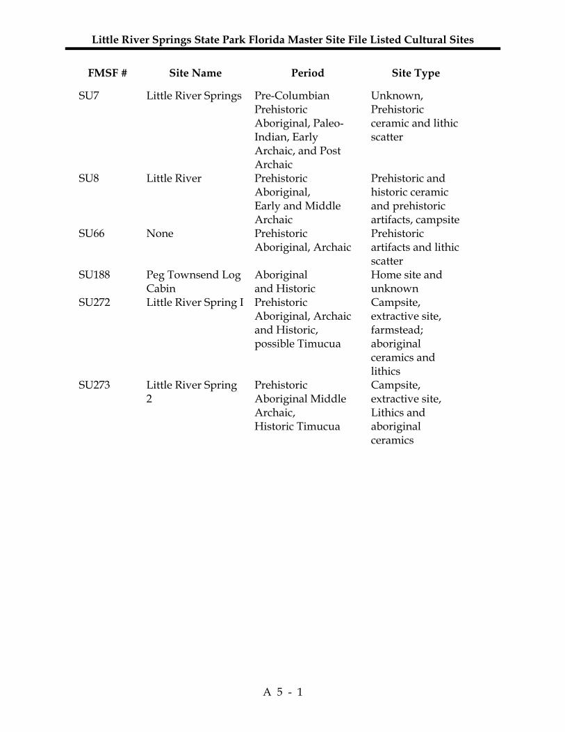
Little River Springs State Park Florida Master Site File Listed Cultural Sites
A 5 - 1
FMSF # Site Name Period Site Type
SU7 Little River Springs Pre-Columbian Prehistoric Aboriginal, Paleo-Indian, Early Archaic, and Post Archaic
Unknown, Prehistoric ceramic and lithic scatter
SU8 Little River Prehistoric Aboriginal, Early and Middle Archaic
Prehistoric and historic ceramic and prehistoric artifacts, campsite
SU66 None Prehistoric Aboriginal, Archaic
Prehistoric artifacts and lithic scatter
SU188 Peg Townsend Log Cabin
Aboriginal and Historic
Home site and unknown
SU272 Little River Spring I Prehistoric Aboriginal, Archaic and Historic, possible Timucua
Campsite, extractive site, farmstead; aboriginal ceramics and lithics
SU273 Little River Spring 2
Prehistoric Aboriginal Middle Archaic, Historic Timucua
Campsite, extractive site, Lithics and aboriginal ceramics

Little River Springs State Park Florida Master Site File Listed Cultural Sites
A 5 - 2

Addendum 6—Priority Schedule And Cost Estimates

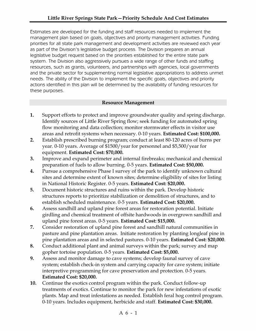
Little River Springs State Park—Priority Schedule And Cost Estimates
A 6 - 1
Estimates are developed for the funding and staff resources needed to implement the management plan based on goals, objectives and priority management activities. Funding priorities for all state park management and development activities are reviewed each year as part of the Division’s legislative budget process. The Division prepares an annual legislative budget request based on the priorities established for the entire state park system. The Division also aggressively pursues a wide range of other funds and staffing resources, such as grants, volunteers, and partnerships with agencies, local governments and the private sector for supplementing normal legislative appropriations to address unmet needs. The ability of the Division to implement the specific goals, objectives and priority actions identified in this plan will be determined by the availability of funding resources for these purposes.
Resource Management 1. Support efforts to protect and improve groundwater quality and spring discharge.
Identify sources of Little River Spring flow; seek funding for automated spring flow monitoring and data collection; monitor stormwater effects in visitor use areas and retrofit systems when necessary. 0-10 years. Estimated Cost: $100,000.
2. Establish prescribed burning program; conduct at least 80-120 acres of burns per year. 0-10 years. Average of $1500/year for personnel and $5,500/year for equipment. Estimated Cost: $70,000.
3. Improve and expand perimeter and internal firebreaks; mechanical and chemical preparation of fuels to allow burning. 0-5 years. Estimated Cost: $50,000.
4. Pursue a comprehensive Phase I survey of the park to identify unknown cultural sites and determine extent of known sites; determine eligibility of sites for listing in National Historic Register. 0-5 years. Estimated Cost: $20,000.
5. Document historic structures and ruins within the park. Develop historic structures reports to prioritize stabilization or demolition of structures, and to establish scheduled maintenance. 0-5 years. Estimated Cost: $20,000.
6. Assess sandhill and upland pine forest areas for restoration potential. Initiate girdling and chemical treatment of offsite hardwoods in overgrown sandhill and upland pine forest areas. 0-5 years. Estimated Cost: $15,000.
7. Consider restoration of upland pine forest and sandhill natural communities in pasture and pine plantation areas. Initiate restoration by planting longleaf pine in pine plantation areas and in selected pastures. 0-10 years. Estimated Cost: $20,000.
8. Conduct additional plant and animal surveys within the park; survey and map gopher tortoise population. 0-5 years. Estimated Cost: $5,000.
9. Assess and monitor damage to cave systems; develop faunal survey of cave system; establish check-in system and carrying capacity for cave system; initiate interpretive programming for cave preservation and protection. 0-5 years. Estimated Cost: $20,000.
10. Continue the exotics control program within the park. Conduct follow-up treatments of exotics. Continue to monitor the park for new infestations of exotic plants. Map and treat infestations as needed. Establish feral hog control program. 0-10 years. Includes equipment, herbicide and staff. Estimated Cost: $30,000.
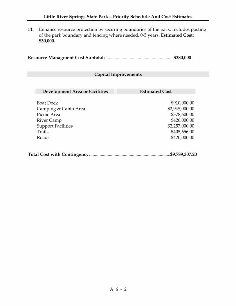
Little River Springs State Park—Priority Schedule And Cost Estimates
A 6 - 2
11. Enhance resource protection by securing boundaries of the park. Includes posting of the park boundary and fencing where needed. 0-5 years. Estimated Cost: $30,000.
Resource Managment Cost Subtotal: ...........................................................$380,000
Capital Improvements
Development Area or Facilities Estimated Cost Boat Dock $910,000.00 Camping & Cabin Area $2,945,000.00 Picnic Area $378,600.00River Camp $420,000.00Support Facilities $2,257,000.00 Trails $405,656.00Roads $420,000.00
Total Cost with Contingency: .....................................................................$9,789,307.20
Additional Information
FNAI Descriptions
DHR Cultural Management Statement


Descriptions Of Natural Communities Developed By FNAI
1
This summary presents the hierarchical classification and brief descriptions of 82 Natural Communities developed by Florida Natural Areas Inventory and identified as collectively constituting the original, natural biological associations of Florida.
A Natural Community is defined as a distinct and recurring assemblage of populations of plants, animals, fungi and microorganisms naturally associated with each other and their physical environment. For more complete descriptions, see Guide to the Natural Communities of Florida, available from Florida Department of Natural Resources.
The levels of the hierarchy are:
Natural Community Category - defined by hydrology and vegetation.
Natural Community Groups - defined by landform, substrate, and vegetation.
Natural Community Type - defined by landform and substrate; soil moisture condition; climate; fire; and characteristic vegetation.
TERRESTRIAL COMMUNITIES
XERIC UPLANDS COASTAL UPLANDS
MESIC UPLANDS ROCKLANDS
MESIC FLATLANDS
PALUSTRINE COMMUNITIES
WET FLATLANDS SEEPAGE WETLANDS
FLOODPLAIN WETLANDS BASIN WETLANDS
LACUSTRINE COMMUNITIES
RIVERINE COMMUNITIES
SUBTERRANEAN COMMUNITIES
MARINE/ESTUARINE COMMUNITIES
Definitions of Terms Used in Natural Community Descriptions
TERRESTRIAL - Upland habitats dominated by plants which are not adapted to anaerobic soil conditions imposed by saturation or inundation for more than 10% of the growing season.
XERIC UPLANDS - very dry, deep, well-drained hills of sand with xeric-adapted vegetation.
Sandhill - upland with deep sand substrate; xeric; temperate; frequent fire (2-5 years); longleaf pine and/or turkey oak with wiregrass understory.
Scrub - old dune with deep fine sand substrate; xeric; temperate or subtropical; occasional or rare fire (20 - 80 years); sand pine and/or scrub oaks and/or rosemary and lichens.
Xeric Hammock - upland with deep sand substrate; xeric-mesic; temperate or subtropical; rare or no fire; live oak and/or sand live oak and/or laurel oak and/or other oaks, sparkleberry, saw palmetto.
COASTAL UPLANDS - substrate and vegetation influenced primarily by such coastal (maritime) processes as erosion, deposition, salt spray, and storms.
Beach Dune - active coastal dune with sand substrate; xeric; temperate or subtropical; occasional or rare fire; sea oats and/or mixed salt-spray tolerant grasses and herbs.
Coastal Berm - old bar or storm debris with sand/shell substrate; xeric-mesic; subtropical or temperate; rare or no fire; buttonwood, mangroves, and/or mixed halophytic herbs and/or shrubs and trees.
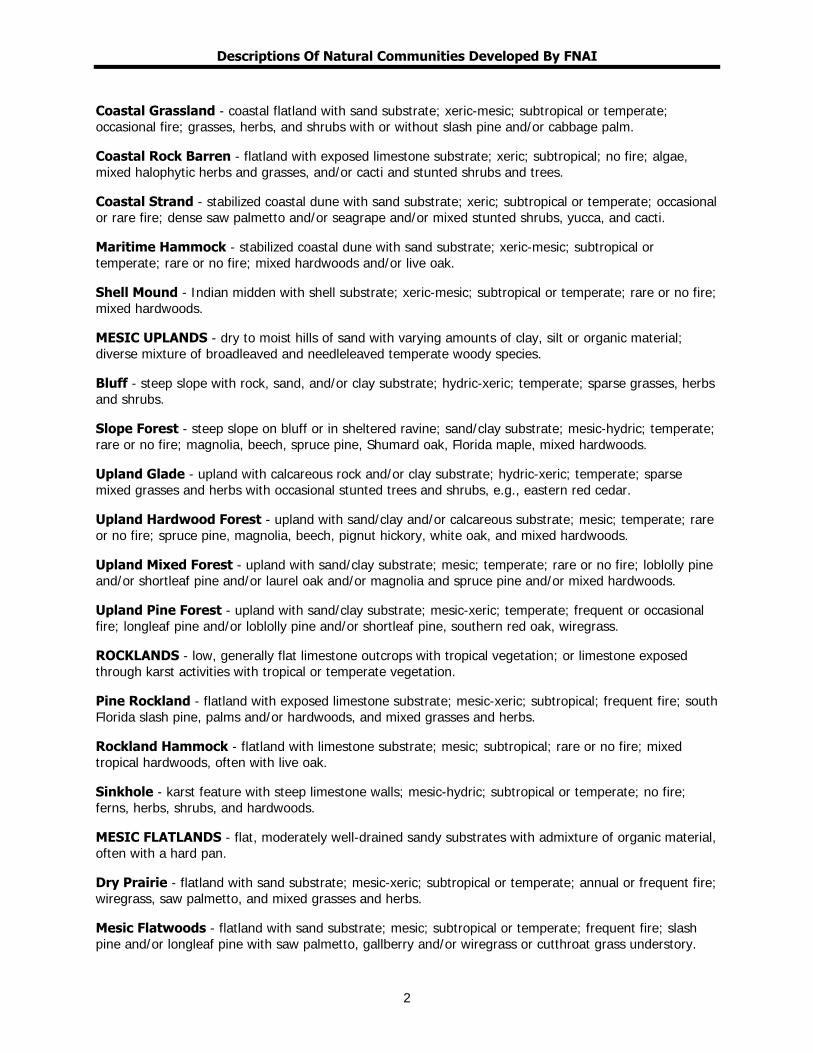
Descriptions Of Natural Communities Developed By FNAI
2
Coastal Grassland - coastal flatland with sand substrate; xeric-mesic; subtropical or temperate; occasional fire; grasses, herbs, and shrubs with or without slash pine and/or cabbage palm.
Coastal Rock Barren - flatland with exposed limestone substrate; xeric; subtropical; no fire; algae, mixed halophytic herbs and grasses, and/or cacti and stunted shrubs and trees.
Coastal Strand - stabilized coastal dune with sand substrate; xeric; subtropical or temperate; occasional or rare fire; dense saw palmetto and/or seagrape and/or mixed stunted shrubs, yucca, and cacti.
Maritime Hammock - stabilized coastal dune with sand substrate; xeric-mesic; subtropical or temperate; rare or no fire; mixed hardwoods and/or live oak.
Shell Mound - Indian midden with shell substrate; xeric-mesic; subtropical or temperate; rare or no fire; mixed hardwoods.
MESIC UPLANDS - dry to moist hills of sand with varying amounts of clay, silt or organic material; diverse mixture of broadleaved and needleleaved temperate woody species.
Bluff - steep slope with rock, sand, and/or clay substrate; hydric-xeric; temperate; sparse grasses, herbs and shrubs.
Slope Forest - steep slope on bluff or in sheltered ravine; sand/clay substrate; mesic-hydric; temperate; rare or no fire; magnolia, beech, spruce pine, Shumard oak, Florida maple, mixed hardwoods.
Upland Glade - upland with calcareous rock and/or clay substrate; hydric-xeric; temperate; sparse mixed grasses and herbs with occasional stunted trees and shrubs, e.g., eastern red cedar.
Upland Hardwood Forest - upland with sand/clay and/or calcareous substrate; mesic; temperate; rare or no fire; spruce pine, magnolia, beech, pignut hickory, white oak, and mixed hardwoods.
Upland Mixed Forest - upland with sand/clay substrate; mesic; temperate; rare or no fire; loblolly pine and/or shortleaf pine and/or laurel oak and/or magnolia and spruce pine and/or mixed hardwoods.
Upland Pine Forest - upland with sand/clay substrate; mesic-xeric; temperate; frequent or occasional fire; longleaf pine and/or loblolly pine and/or shortleaf pine, southern red oak, wiregrass.
ROCKLANDS - low, generally flat limestone outcrops with tropical vegetation; or limestone exposed through karst activities with tropical or temperate vegetation.
Pine Rockland - flatland with exposed limestone substrate; mesic-xeric; subtropical; frequent fire; south Florida slash pine, palms and/or hardwoods, and mixed grasses and herbs.
Rockland Hammock - flatland with limestone substrate; mesic; subtropical; rare or no fire; mixed tropical hardwoods, often with live oak.
Sinkhole - karst feature with steep limestone walls; mesic-hydric; subtropical or temperate; no fire; ferns, herbs, shrubs, and hardwoods.
MESIC FLATLANDS - flat, moderately well-drained sandy substrates with admixture of organic material, often with a hard pan.
Dry Prairie - flatland with sand substrate; mesic-xeric; subtropical or temperate; annual or frequent fire; wiregrass, saw palmetto, and mixed grasses and herbs.
Mesic Flatwoods - flatland with sand substrate; mesic; subtropical or temperate; frequent fire; slash pine and/or longleaf pine with saw palmetto, gallberry and/or wiregrass or cutthroat grass understory.
Descriptions Of Natural Communities Developed By FNAI
3
Prairie Hammock - flatland with sand/organic soil over marl or limestone substrate; mesic; subtropical; occasional or rare fire; live oak and/or cabbage palm.
Scrubby Flatwoods - flatland with sand substrate; xeric-mesic; subtropical or temperate; occasional fire; longleaf pine or slash pine with scrub oaks and wiregrass understory.
PALUSTRINE - Wetlands dominated by plants adapted to anaerobic substrate conditions imposed by substrate saturation or inundation during 10% or more of the growing season. Includes non-tidal wetlands; tidal wetlands with ocean derived salinities less than 0.5 ppt and dominance by salt-intolerant species; small (less than 8 ha), shallow (less than 2 m deep at low water) water bodies without wave-formed or bedrock shoreline; and inland brackish or saline wetlands.
WET FLATLANDS - flat, poorly drained sand, marl or limestone substrates.
Hydric Hammock - lowland with sand/clay/organic soil, often over limestone; mesic-hydric; subtropical or temperate; rare or no fire; water oak, cabbage palm, red cedar, red maple, bays, hackberry, hornbeam, blackgum, needle palm, and mixed hardwoods.
Marl Prairie - flatland with marl over limestone substrate; seasonally inundated; tropical; frequent to no fire; sawgrass, spikerush, and/or mixed grasses, sometimes with dwarf cypress.
Wet Flatwoods - flatland with sand substrate; seasonally inundated; subtropical or temperate; frequent fire; vegetation characterized by slash pine or pond pine and/or cabbage palm with mixed grasses and herbs.
Wet Prairie - flatland with sand substrate; seasonally inundated; subtropical or temperate; annual or frequent fire; maidencane, beakrush, spikerush, wiregrass, pitcher plants, St. John's wort, mixed herbs.
SEEPAGE WETLANDS - sloped or flat sands or peat with high moisture levels maintained by downslope seepage; wetland and mesic woody and/or herbaceous vegetation.
Baygall - wetland with peat substrate at base of slope; maintained by downslope seepage, usually saturated and occasionally inundated; subtropical or temperate; rare or no fire; bays and/or dahoon holly and/or red maple and/or mixed hardwoods.
Seepage Slope - wetland on or at base of slope with organic/sand substrate; maintained by downslope seepage, usually saturated but rarely inundated; subtropical or temperate; frequent or occasional fire; sphagnum moss, mixed grasses and herbs or mixed hydrophytic shrubs.
FLOODPLAIN WETLANDS - flat, alluvial sand or peat substrates associated with flowing water courses and subjected to flooding but not permanent inundation; wetland or mesic woody and herbaceous vegetation.
Bottomland Forest - flatland with sand/clay/organic substrate; occasionally inundated; temperate; rare or no fire; water oak, red maple, beech, magnolia, tuliptree, sweetgum, bays, cabbage palm, and mixed hardwoods.
Floodplain Forest - floodplain with alluvial substrate of sand, silt, clay or organic soil; seasonally inundated; temperate; rare or no fire; diamondleaf oak, overcup oak, water oak, swamp chestnut oak, blue palmetto, cane, and mixed hardwoods.
Floodplain Marsh - floodplain with organic/sand/alluvial substrate; seasonally inundated; subtropical; frequent or occasional fire; maidencane, pickerelweed, sagittaria spp., buttonbush, and mixed emergents.
Floodplain Swamp - floodplain with organic/alluvial substrate; usually inundated; subtropical or temperate; rare or no fire; vegetation characterized by cypress, tupelo, black gum, and/or pop ash.
Descriptions Of Natural Communities Developed By FNAI
4
Freshwater Tidal Swamp - river mouth wetland, organic soil with extensive root mat; inundated with freshwater in response to tidal cycles; rare or no fire; cypress, bays, cabbage palm, gums and/or cedars.
Slough - broad, shallow channel with peat over mineral substrate; seasonally inundated, flowing water; subtropical; occasional or rare fire; pop ash and/or pond apple or water lily.
Strand Swamp - broad, shallow channel with peat over mineral substrate; seasonally inundated, flowing water; subtropical; occasional or rare fire; cypress and/or willow.
Swale - broad, shallow channel with sand/peat substrate; seasonally inundated, flowing water; subtropical or temperate; frequent or occasional fire; sawgrass, maidencane, pickerelweed, and/or mixed emergents.
BASIN WETLANDS - shallow, closed basin with outlet usually only in time of high water; peat or sand substrate, usually inundated; wetland woody and/or herbaceous vegetation.
Basin Marsh - large basin with peat substrate; seasonally inundated; temperate or subtropical; frequent fire; sawgrass and/or cattail and/or buttonbush and/or mixed emergents.
Basin Swamp - large basin with peat substrate; seasonally inundated, still water; subtropical or temperate; occasional or rare fire; vegetation characterized by cypress, blackgum, bays and/or mixed hardwoods.
Bog - wetland on deep peat substrate; moisture held by sphagnum mosses, soil usually saturated, occasionally inundated; subtropical or temperate; rare fire; sphagnum moss and titi and/or bays and/or dahoon holly, and/or mixed hydrophytic shrubs.
Coastal Interdunal Swale - long narrow depression wetlands in sand/peat-sand substrate; seasonally inundated, fresh to brackish, still water; temperate; rare fire; graminoids and mixed wetland forbs.
Depression Marsh - small rounded depression in sand substrate with peat accumulating toward center; seasonally inundated, still water; subtropical or temperate; frequent or occasional fire; maidencane, fire flag, pickerelweed, and mixed emergents, may be in concentric bands.
Dome Swamp - rounded depression in sand/limestone substrate with peat accumulating toward center; seasonally inundated, still water; subtropical or temperate; occasional or rare fire; cypress, blackgum, or bays, often tallest in center.
LACUSTRINE - Non-flowing wetlands of natural depressions lacking persistent emergent vegetation except around the perimeter.
Clastic Upland Lake - generally irregular basin in clay uplands; predominantly with inflows, frequently without surface outflow; clay or organic substrate; colored, acidic, soft water with low mineral content (sodium, chloride, sulfate); oligo-mesotrophic to eutrophic.
Coastal Dune Lake - basin or lagoon influenced by recent coastal processes; predominantly sand substrate with some organic matter; salinity variable among and within lakes, and subject to saltwater intrusion and storm surges; slightly acidic, hard water with high mineral content (sodium, chloride).
Coastal Rockland Lake - shallow basin influence by recent coastal processes; predominantly barren oolitic or Miami limestone substrate; salinity variable among and within lakes, and subject to saltwater intrusion, storm surges and evaporation (because of shallowness); slightly alkaline, hard water with high mineral content (sodium, chloride).
Flatwoods/Prairie Lake - generally shallow basin in flatlands with high water table; frequently with a

Descriptions Of Natural Communities Developed By FNAI
5
broad littoral zone; still water or flow-through; sand or peat substrate; variable water chemistry, but characteristically colored to clear, acidic to slightly alkaline, soft to moderately hard water with moderate mineral content (sodium, chloride, sulfate); oligo-mesotrophic to eutrophic.
Marsh lake - generally shallow, open water area within wide expanses of freshwater marsh; still water or flow-through; peat, sand or clay substrate; occurs in most physiographic regions; variable water chemistry, but characteristically highly colored, acidic, soft water with moderate mineral content (sodium, chloride, sulfate); oligo-mesotrophic to eutrophic.
River Floodplain Lake - meander scar, backwater, or larger flow-through body within major river floodplains; sand, alluvial or organic substrate; colored, alkaline or slightly acidic, hard or moderately hard water with high mineral content (sulfate, sodium, chloride, calcium, magnesium); mesotrophic to eutrophic.
Sandhill Upland Lake - generally rounded solution depression in deep sandy uplands or sandy uplands shallowly underlain by limestone; predominantly without surface inflows/outflows; typically sand substrate with organic accumulations toward middle; clear, acidic moderately soft water with varying mineral content; ultra-oligotrophic to mesotrophic.
Sinkhole Lake - typically deep, funnel-shaped depression in limestone base; occurs in most physiographic regions; predominantly without surface inflows/outflows, but frequently with connection to the aquifer; clear, alkaline, hard water with high mineral content (calcium, bicarbonate, magnesium).
Swamp Lake - generally shallow, open water area within basin swamps; still water or flow-through; peat, sand or clay substrate; occurs in most physiographic regions; variable water chemistry, but characteristically highly colored, acidic, soft water with moderate mineral content (sodium, chloride, sulfate); oligo-mesotrophic to eutrophic.
RIVERINE - Natural, flowing waters from their source to the downstream limits of tidal influence and bounded by channel banks.
Alluvial Stream - lower perennial or intermittent/seasonal watercourse characterized by turbid water with suspended silt, clay, sand and small gravel; generally with a distinct, sediment-derived (alluvial) floodplain and a sandy, elevated natural levee just inland from the bank.
Blackwater Stream - perennial or intermittent/seasonal watercourse characterized by tea-colored water with a high content of particulate and dissolved organic matter derived from drainage through swamps and marshes; generally lacking an alluvial floodplain.
Seepage Stream - upper perennial or intermittent/seasonal watercourse characterized by clear to lightly colored water derived from shallow groundwater seepage.
Spring-run Stream - perennial watercourse with deep aquifer headwaters and characterized by clear water, circumneutral pH and, frequently, a solid limestone bottom.
SUBTERRANEAN - Twilight, middle and deep zones of natural chambers overlain by the earth's crust and characterized by climatic stability and assemblages of trogloxenic, troglophilic, and troglobitic organisms.
Aquatic Cave - cavernicolous area permanently or periodically submerged; often characterized by troglobitic crustaceans and salamanders; includes high energy systems which receive large quantities of organic detritus and low energy systems.
Terrestrial Cave - cavernicolous area lacking standing water; often characterized by bats, such as Myotis spp., and other terrestrial vertebrates and invertebrates; includes interstitial areas above standing
Descriptions Of Natural Communities Developed By FNAI
6
water such as fissures in the ceiling of caves.
MARINE/ESTUARINE (The distinction between the Marine and Estuarine Natural Communities is often subtle, and the natural communities types found under these two community categories have the same descriptions. For these reasons they have been grouped together.) - Subtidal, intertidal and supratidal zones of the sea, landward to the point at which seawater becomes significantly diluted with freshwater inflow from the land.
Consolidated Substrate - expansive subtidal, intertidal and supratidal area composed primarily of nonliving compacted or coherent and relatively hard, naturally formed mass of mineral matter (e.g., coquina limerock and relic reefs); octocorals, sponges, stony corals, nondrift macrophytic algae, blue-green mat-forming algae and seagrasses sparse, if present.
Unconsolidated Substrate - expansive subtidal, intertidal and supratidal area composed primarily of loose mineral matter (e.g., coralgal, gravel, marl, mud, sand and shell); octocorals, sponges, stony corals, nondrift macrophytic algae, blue-green mat-forming algae and seagrasses sparse, if present.
Octocoral Bed - expansive subtidal area occupied primarily by living sessile organisms of the Class Anthozoa, Subclass Octocorallia (e.g., soft corals, horny corals, sea fans, sea whips, and sea pens); sponges, stony corals, nondrift macrophytic algae and seagrasses spares, if present.
Sponge Bed - expansive subtidal area occupied primarily by living sessile organisms of the Phylum Porifera (e.g., sheepswool sponge, Florida loggerhead sponge and branching candle sponge); octocorals, stony corals, nondrift macrophytic algae and seagrasses sparse, if present.
Coral Reef - expansive subtidal area with elevational gradient or relief and occupied primarily by living sessile organisms of the Class Hydrozoa (e.g., fire corals and hydrocorals) and Class Anthozoa, Subclass Zoantharia (e.g., stony corals and black corals); includes deepwater bank reefs, fringing barrier reefs, outer bank reefs and patch reefs, some of which may contain distinct zones of assorted macrophytes, octocorals, & sponges.
Mollusk Reef - substantial subtidal or intertidal area with relief from concentrations of sessile organisms of the Phylum Mollusca, Class Bivalvia (e.g., molluscs, oysters, & worm shells); octocorals, sponges, stony corals, macrophytic algae and seagrasses sparse, if present.
Worm Reef - substantial subtidal or intertidal area with relief from concentrations of sessile, tubicolous organisms of the Phylum Annelida, Class Polychaeta (e.g., chaetopterids and sabellarids); octocorals, sponges, stony corals, macrophytic algae and seagrasses sparse, if present.
Algal Bed - expansive subtidal, intertidal or supratidal area, occupied primarily by attached thallophytic or mat-forming prokaryotic algae (e.g, halimeda, blue-green algae); octocorals, sponges, stony corals and seagrasses sparse, if present.
Grass Bed - expansive subtidal or intertidal area, occupied primarily by rooted vascular macrophytes, (e.g., shoal grass, halophila, widgeon grass, manatee grass and turtle grass); may include various epiphytes and epifauna; octocorals, sponges, stony corals, and attached macrophytic algae sparse, if present.
Composite Substrate - expansive subtidal, intertidal, or supratidal area, occupied primarily by Natural Community elements from more than one Natural Community category (e.g., Grass Bed and Algal Bed species; Octocoral and Algal Bed species); includes both patchy and evenly distributed occurrences.
Tidal Marsh - expansive intertidal or supratidal area occupied primarily by rooted, emergent vascular macrophytes (e.g., cord grass, needlerush, saw grass, saltwort, saltgrass and glasswort); may include various epiphytes and epifauna.

Descriptions Of Natural Communities Developed By FNAI
7
Tidal Swamp - expansive intertidal and supratidal area occupied primarily by woody vascular macrophytes (e.g., black mangrove, buttonwood, red mangrove, and white mangrove); may include various epiphytes and epifauna.

Descriptions Of Natural Communities Developed By FNAI
8
DEFINITIONS OF TERMS Terrestrial and Palustrine Natural Communities
Physiography Upland - high area in region with significant topographic relief; generally undulating Lowland - low area in region with or without significant topographic relief; generally flat to gently sloping Flatland - generally level area in region without significant topographic relief; flat to gently sloping Basin - large, relatively level lowland with slopes confined to the perimeter or isolated interior locations Depression - small depression with sloping sides, deepest in center and progressively shallower towards the perimeter Floodplain - lowland adjacent to a stream; topography influenced by recent fluvial processes Bottomland - lowland not on active floodplain; sand/clay/organic substrate
Hydrology occasionally inundated - surface water present only after heavy rains and/or during flood stages seasonally inundated - surface water present during wet season and flood periods usually inundated - surface water present except during droughts
Climatic Affinity of the Flora tropical - community generally occurs in practically frost-free areas subtropical - community generally occurs in areas that experience occasional frost, but where freezing temperatures are not frequent enough to cause true winter dormancy temperate - community generally occurs in areas that freeze often enough that vegetation goes into winter dormancy
Fire annual fire - burns about every 1-2 years frequent fire - burns about every 3-7 years occasional fire - burns about every 8-25 years rare fire - burns about every 26-100 years no fire - community develops only when site goes more than 100 years without burning
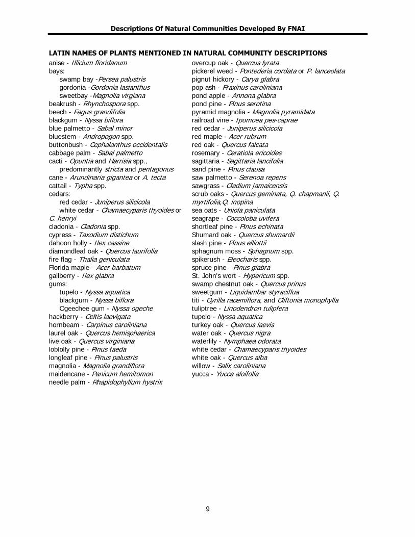
Descriptions Of Natural Communities Developed By FNAI
9
LATIN NAMES OF PLANTS MENTIONED IN NATURAL COMMUNITY DESCRIPTIONS anise - Illicium floridanum bays: swamp bay -Persea palustris gordonia -Gordonia lasianthus sweetbay -Magnolia virgiana beakrush - Rhynchospora spp. beech - Fagus grandifolia blackgum - Nyssa biflora blue palmetto - Sabal minor bluestem - Andropogon spp. buttonbush - Cephalanthus occidentalis cabbage palm - Sabal palmetto cacti - Opuntia and Harrisia spp., predominantly stricta and pentagonus cane - Arundinaria gigantea or A. tecta cattail - Typha spp. cedars: red cedar - Juniperus silicicola white cedar - Chamaecyparis thyoides or C. henryi cladonia - Cladonia spp. cypress - Taxodium distichum dahoon holly - Ilex cassine diamondleaf oak - Quercus laurifolia fire flag - Thalia geniculata Florida maple - Acer barbatum gallberry - Ilex glabra gums: tupelo - Nyssa aquatica blackgum - Nyssa biflora Ogeechee gum - Nyssa ogeche hackberry - Celtis laevigata hornbeam - Carpinus caroliniana laurel oak - Quercus hemisphaerica live oak - Quercus virginiana loblolly pine - Pinus taeda longleaf pine - Pinus palustris magnolia - Magnolia grandiflora maidencane - Panicum hemitomon needle palm - Rhapidophyllum hystrix
overcup oak - Quercus lyrata pickerel weed - Pontederia cordata or P. lanceolata pignut hickory - Carya glabra pop ash - Fraxinus caroliniana pond apple - Annona glabra pond pine - Pinus serotina pyramid magnolia - Magnolia pyramidata railroad vine - Ipomoea pes-caprae red cedar - Juniperus silicicola red maple - Acer rubrum red oak - Quercus falcata rosemary - Ceratiola ericoides sagittaria - Sagittaria lancifolia sand pine - Pinus clausa saw palmetto - Serenoa repens sawgrass - Cladium jamaicensis scrub oaks - Quercus geminata, Q. chapmanii, Q. myrtifolia,Q. inopina sea oats - Uniola paniculata seagrape - Coccoloba uvifera shortleaf pine - Pinus echinata Shumard oak - Quercus shumardii slash pine - Pinus elliottii sphagnum moss - Sphagnum spp. spikerush - Eleocharis spp. spruce pine - Pinus glabra St. John's wort - Hypericum spp. swamp chestnut oak - Quercus prinus sweetgum - Liquidambar styraciflua titi - Cyrilla racemiflora, and Cliftonia monophylla tuliptree - Liriodendron tulipfera tupelo - Nyssa aquatica turkey oak - Quercus laevis water oak - Quercus nigra waterlily - Nymphaea odorata white cedar - Chamaecyparis thyoides white oak - Quercus alba willow - Salix caroliniana yucca - Yucca aloifolia

Descriptions Of Natural Communities Developed By FNAI
10
Management Procedures for Archaeological and Historical Sites and Properties on State-Owned or Controlled Properties (revised February 2007)
11
These procedures apply to state agencies, local governments, and non-profits that manage state-owned properties.
A. General Discussion Historic resources are both archaeological sites and historic structures. Per Chapter 267, Florida Statutes, ‘Historic property’ or ‘historic resource’ means any prehistoric district, site, building, object, or other real or personal property of historical, architectural, or archaeological value, and folklife resources. These properties or resources may include, but are not limited to, monuments, memorials, Indian habitations, ceremonial sites, abandoned settlements, sunken or abandoned ships, engineering works, treasure trove, artifacts, or other objects with intrinsic historical or archaeological value, or any part thereof, relating to the history, government, and culture of the state.” B. Agency Responsibilities Per State Policy relative to historic properties, state agencies of the executive branch must allow the Division of Historical Resources (Division) the opportunity to comment on any undertakings, whether these undertakings directly involve the state agency, i.e., land management responsibilities, or the state agency has indirect jurisdiction, i.e. permitting authority, grants, etc. No state funds should be expended on the undertaking until the Division has the opportunity to review and comment on the project, permit, grant, etc. State agencies shall preserve the historic resources which are owned or controlled by the agency. Regarding proposed demolition or substantial alterations of historic properties, consultation with the Division must occur, and alternatives to demolition must be considered. State agencies must consult with Division to establish a program to location, inventory and evaluate all historic properties under ownership or controlled by the agency. C. Statutory Authority Statutory Authority and more in depth information can be found in the following: Chapter 253, F.S. – State Lands Chapter 267, F.S. – Historical Resources Chapter 872, F.S. – Offenses Concerning Dead Bodies and Graves Other helpful citations and references: Chapter 1A-32, F.A.C. – Archaeological Research Other helpful citations and references: Chapter 1A-44, F.A.C. – Procedures for Reporting and Determining Jurisdiction Over Unmarked Human Burials Chapter 1A-46, F.A C. – Archaeological and Historical Report Standards and Guidelines The Secretary of the Interior’s Standards for Rehabilitation and Guidelines for Rehabilitating Historic Buildings
Management Procedures For Archaeological And Historical Sites And Properties On State-Owned Or Controlled Lands (Revised August, 1995)
12
D. Management Implementation Even though the Division sits on the Acquisition and Restoration Council and approves land management plans, these plans are conceptual. Specific information regarding individual projects must be submitted to the Division for review and recommendations. Managers of state lands must coordinate any land clearing or ground disturbing activities with the Division to allow for review and comment on the proposed project. Recommendations may include, but are not limited to: approval of the project as submitted, pre-testing of the project site by a certified archaeological monitor, cultural resource assessment survey by a qualified professional archaeologist, modifications to the proposed project to avoid or mitigate potential adverse effects. Projects such as additions, exterior alteration, or related new construction regarding historic structures must also be submitted to the Division of Historical Resources for review and comment by the Division’s architects. Projects involving structures fifty years of age or older, must be submitted to this agency for a significance determination. In rare cases, structures under fifty years of age may be deemed historically significant. These must be evaluated on a case by case basis. Adverse impacts to significant sites, either archaeological sites or historic buildings, must be avoided. Furthermore, managers of state property should make preparations for locating and evaluating historic resources, both archaeological sites and historic structures. E. Minimum Review Documentation Requirements In order to have a proposed project reviewed by the Division, the following information, at a minimum, must be submitted for comments and recommendations. Project Description – A detailed description of the proposed project including all related activities. For land clearing or ground disturbing activities, the depth and extent of the disturbance, use of heavy equipment, location of lay down yard, etc. For historic structures, specific details regarding rehabilitation, demolition, etc. Project Location – The exact location of the project indicated on a USGS Quadrangle map, is preferable. A management base map may be acceptable. Aerial photos indicating the exact project area as supplemental information are helpful. Photographs – Photographs of the project area are always useful. Photographs of structures are required. Description of Project Area – Note the acreage of the project, describe the present condition of project area, and any past land uses or disturbances. Description of Structures – Describe the condition and setting of each building within project area if approximately fifty years of age or older. Recorded Archaeological Sites or Historic Structures – Provide Florida Master Site File numbers for all recorded historic resources within or adjacent to the project area. This information should be in the current management plan; however, it can be obtained by contacting the Florida Master Site File at (850) 245-6440 or Suncom 205-6440.
Management Procedures For Archaeological And Historical Sites And Properties On State-Owned Or Controlled Lands (Revised August, 1995)
13
Questions relating to the treatment of archaeological and historic resources on state lands should be directed to:
Susan M. Harp Historic Preservation Planner
Division of Historical Resources Bureau of Historic Preservation Compliance and Review Section
R. A. Gray Building 500 South Bronough Street
Tallahassee, FL 32399-0250
Phone:(850) 245-6333 Suncom: 205-6333 Fax: (850) 245-6438

14