literature review for maritime isr modelingcradpdf.drdc-rddc.gc.ca/pdfs/unc199/p800978_a1b.pdf ·...
TRANSCRIPT

Literature review for maritime ISR modeling
John Brennan, Senior Solution Architect CAE Inc. Prepared by: CAE Inc. 1135 Innovation Dr., Ottawa, Ont., K2K 3G7 Contractor's Document Number: 5733-001 Version 01 Contract Project Manager: Damon Gamble PWGSC Contract Number: W7714-083663/001/SV, Task #179 CSA: Peter Dobias, Team Leader, Maritime Forces Pacific, Operational Research Team, 250-363-2814 The scientific or technical validity of this Contract Report is entirely the responsibility of the Contractor and the contents do not necessarily have the approval or endorsement of the Department of National Defence of Canada.
Contract Report DRDC-RDDC-2015-C014 February 2015

© Her Majesty the Queen in Right of Canada (Department of National Defence), 2015
© Sa Majesté la Reine en droit du Canada (Ministère de la Défense nationale), 2015

CAE Inc.1135 Innovation Dr.
Ottawa, Ont., K2K 3G7 CanadaTelephone: 613-247-0342
Fax: 613-271-0963
DRDC CORA TASK #179LITERATURE REVIEW FORMARITIME ISR MODELLING
FOR
DR. PETER DOBIAS
Team LeaderMARPAC N02 Operational Research
Victoria, BC
0 9 F e b r u a r y 2 0 1 5
Document No. 5733-001 Version 01
© Her Majesty the Queen in Right of Canada (2015)
© Sa Majesté la Reine en droit du Canada, (2015)


DRDC CORA Task #179Literature Review for
Maritime ISR Modelling
09 February 2015 – iii – 5733-001 Version 01
R E V I S I O N H I S T O R Y
Revision Reason for Change Origin Date
Version 01 Initial document issued 09 February 2015

DRDC CORA Task #179Literature Review for
Maritime ISR Modelling
09 February 2015 – iv – 5733-001 Version 01
T A B L E O F C O N T E N T S
1 INTRODUCTION..................................................................................................... 1 1.1 Background .......................................................................................................... 1 1.2 Objective .............................................................................................................. 1 1.3 Scope ................................................................................................................... 1 1.4 Outline .................................................................................................................. 2
2 ESTABLISHING THE CONTEXT ........................................................................... 3 2.1 Modelling .............................................................................................................. 3 2.2 ISR Defined .......................................................................................................... 3 2.3 Maritime Domain ISR Described .......................................................................... 6 2.4 An ISR Conceptual Model .................................................................................... 6 2.5 The Maritime Domain Target Set.......................................................................... 9
3 MODELLING ISR.................................................................................................. 12 3.1 General Aspects of ISR Modelling...................................................................... 12 3.2 Fidelity as Related to ISR Modelling................................................................... 14 3.3 Characteristics and Attributes of ISR Models ..................................................... 15 3.4 Approaches and Methodologies for ISR Modelling............................................. 21 3.4.1 Purpose Driven Approaches ............................................................................ 22 3.4.2 Addressing Uncertainty.................................................................................... 24 3.5 Sensor Coverage Analyses ................................................................................ 27 3.5.1 General Coverage Aspects.............................................................................. 27 3.5.2 Sensing and Detection Modelling .................................................................... 29 3.5.3 STK Coverage Description .............................................................................. 30
4 ISR TOOLS AND CAPABILITIES ........................................................................ 33 4.1 Tools and Capabilities Discovered ..................................................................... 33 4.1.1 System Tool Kit (STK) ..................................................................................... 33 4.1.2 System Effectiveness Analysis Simulation (SEAS).......................................... 34 4.1.3 Virtual ISR Evaluation Environment (VIEE) ..................................................... 36 4.1.4 Map Aware Non-uniform Automata (MANA) .................................................... 37 4.1.5 C4ISR Analytic Performance Evaluation (CAPE) ............................................ 40 4.1.6 Valuing Persistent ISR Resources (VPR) System ........................................... 41 4.1.7 Dynamic Course of Action Decision (DCOAD) Tool......................................... 42 4.1.8 Joint Theater Level Simulation (JTLS)............................................................. 42 4.1.9 Naval Simulation System (NSS) ...................................................................... 45 4.1.10 Joint Platform Allocation Tool (JPAT) .............................................................. 46 4.1.11 Joint Dynamic Allocation of Fires and Sensors (JDAFS) ................................. 46 4.1.12 Larus Technologies.......................................................................................... 47 4.1.13 Fusion Oriented C4ISR Utility Simulation (FOCUS)......................................... 49 4.2 Other Potential Information Sources................................................................... 50

DRDC CORA Task #179Literature Review for
Maritime ISR Modelling
09 February 2015 – v – 5733-001 Version 01
4.2.1 DRDC Atlantic and Canadian Forces Maritime Warfare Centre (CFMWC) ..... 50 4.2.2 Canadian Forces Warfare Centre (CFWC) ...................................................... 50 4.2.3 Center for Naval Analysis (CNA) Corporation.................................................. 50 4.2.4 MITRE.............................................................................................................. 51 4.2.5 Interdepartmental Marine Security Working Group (IMSWG) .......................... 51 4.2.6 Naval Postgraduate School (NPS)................................................................... 51 4.2.7 Institute for Defense Analyses (IDA) ................................................................ 52
5 DISCUSSION & SUMMARY................................................................................. 53 5.1 Discussion .......................................................................................................... 53 5.2 Summary ............................................................................................................ 55
6 ACRONYMS AND ABBREVIATIONS.................................................................. 56
7 REFERENCES...................................................................................................... 59

DRDC CORA Task #179Literature Review for
Maritime ISR Modelling
09 February 2015 – vi – 5733-001 Version 01
L I S T O F F I G U R E S
Figure 2-1: Intelligence Cycle.......................................................................................... 5 Figure 2-2: Generic ISR Process .................................................................................... 5 Figure 2-3: ISR Tactical Level Actions ............................................................................ 6 Figure 2-4: High Level View of ISR ................................................................................. 7 Figure 2-5: ISR Conceptual Model - Operational View.................................................... 8 Figure 2-6: ISR Conceptual Model - Systems & Functional View.................................... 9 Figure 3-1: General Characteristics & Attributes ........................................................... 17 Figure 3-2: Relevant C2 Methods & Tools .................................................................... 20 Figure 3-3: Electromagnetic Spectrum []........................................................................ 27 Figure 3-4: Field of View VS Field of Regard [] .............................................................. 28 Figure 4-1: VIEE Architecture [] ..................................................................................... 37
L I S T O F T A B L E S
Table 2-1: Maritime Domain Target Set Taxonomy......................................................... 9 Table 2-2: Maritime Domain Target Characteristics ...................................................... 10 Table 3-1: ISR Constraints ............................................................................................ 14 Table 3-2: Characteristic & Attribute Details.................................................................. 18 Table 3-3: Relevant Challenges in Representing C2 Systems [] ................................... 20 Table 3-4: Method & Tool Selection Criteria [] ............................................................... 21 Table 4-1: STK Information ........................................................................................... 33 Table 4-2: SEAS Information......................................................................................... 34 Table 4-3: VIEE Information .......................................................................................... 36 Table 4-4 MANA Information......................................................................................... 37 Table 4-5: JTLS Information.......................................................................................... 42 Table 6-1 Acronyms and Abbreviations......................................................................... 56

DRDC CORA Task #179Literature Review for
Maritime ISR Modelling
09 February 2015 – vii – 5733-001 Version 01
E X E C U T I V E S U M M A R Y
The Defence Research and Development Canada (DRDC) Centre for Operational Research and Analysis (CORA) Operational Research Team has a requirement to develop intelligence, surveillance and reconnaissance (ISR) modelling capability. As part of the capability development process the team identified a need to document the existing state-of-the-art in capabilities and methodologies relevant to ISR modelling.
A task was issued to CAE Canada, the objective of which was to conduct a comprehensive survey of available literature dealing with ISR modelling in the context of coastal maritime domain awareness. The results of the survey and literature review are contained in this report.
In an effort to provide context for the reader, the first two sections of this report provide background information, as well as definitions and descriptions of the modelling and ISR domains. This result is the presentation of an ISR conceptual model upon which subsequent information and discussion can be grounded. The conceptual model consists of two main views:an Operational View and a Systems & Functional View.
The next section of the report provides a comprehensive review of the literature and information that was found. The main areas of focus include the relevant characteristics and attributes of ISR models, as well as the approaches and methodologies that were identified. There are also specific discussions on fidelity as related to ISR modelling and the subject of sensor coverage analysis.
The fourth section of this report contains several sub-sections, each of which contains information on specific ISR modelling tools and capabilities that were found during the investigations and reviews. Although efforts were made to contact several organizations and vendors, not all were responsive; therefore, this section also contains information on other potential information sources for further follow-up.
Finally, this report contains a high-level discussion that places the information reviewed during this task into context, providing some thoughts and ideas for further reflection.

DRDC CORA Task #179Literature Review for
Maritime ISR Modelling
09 February 2015 1 5733-001 Version 01
1 INTRODUCTION
This document is the Final Report developed for the project entitled “Literature Review for Maritime ISR Modeling”. This report was completed by CAE Canada under Task #179 for contract #W7714-083663/001/SV to Defence Research Development Canada (DRDC) Centre for Operational Research and Analysis (CORA).
1.1 Background
The DRDC CORA Operational Research Team has a requirement to develop intelligence, surveillance and reconnaissance (ISR) modelling capability. As part of the capability development process the team identified a need to document the existing state-of-the-art in capabilities and methodologies relevant to ISR modelling.
1.2 Objective
The objective of this activity was to conduct a comprehensive survey of available literature dealing with ISR modelling in the context of coastal maritime domain awareness. The following statements were used as a guideline to focus the research:
a) Identify existing models, simulations or tools available within Canada or allied nations, including information regarding the item’s characteristics and uses;
b) Identify any analyses of sensor coverage performed using a variety of land, sea, air and space assets;
c) Identify mathematical methodologies dealing with probability of detection and/or identification that are used to assess sensor performance, with a particular focus on models that use Bayesian statistics and/or non-normal distributions; and
d) Identify examples of ISR modelling capabilities in the maritime / coastal environment.
1.3 Scope
The work conducted under this task is focused on modelling capabilities of two key aspects ofISR: data collection (sensing) and data use (processing). Although there are many sub-areas within these two key aspects, this work maintained primary focus on the ISR level and delved into other specific focus areas (such as data fusion) only when necessary to support a complete description or explanation of ISR items.
The work was also focused on the maritime / coastal environment; however, this focus did not constrain the research conducted. Literature and information related to ISR modelling within other domains (land and air for example) was considered on the assumption that fundamental approaches and methodologies have the potential for reuse and applicability across several domains.

DRDC CORA Task #179Literature Review for
Maritime ISR Modelling
09 February 2015 2 5733-001 Version 01
1.4 Outline
This document contains the following sections:
a) Section 1 – Introduction: a brief description of the background, objective and scope of this work.
b) Section 2 – Establishing the Context: definitions and descriptions of modelling and ISR including formulation of a fit-for-purpose conceptual model, as well as a description of the maritime domain awareness target set.
c) Section 3 – Modelling ISR: a comprehensive review of the literature and information found related to ISR modelling approaches and methodologies, including a discussion on fidelity and characteristics / attributes.
d) Section 4 – ISR Tools and Capabilities: a review of the tools and capabilities found during the course of the work.
e) Section 5 – Discussion and Summary: a discussion and summary of all information reviewed during the course of this work.
f) Section 6 – Acronyms and Abbreviations: a list of acronyms and abbreviations used in the report.
g) Section 7 – References: a list of all information sources that are referenced in this report.

DRDC CORA Task #179Literature Review for
Maritime ISR Modelling
09 February 2015 3 5733-001 Version 01
2 ESTABLISHING THE CONTEXT
This section of the report contains definitions and descriptions of modelling and ISR including formulation of a fit-for-purpose conceptual model. It also includes a description of the maritime domain awareness target set.
2.1 Modelling
In general, a model is a representation of some aspect of the real or imagined world for a specified purpose. The Defence community typically defines a model as, “A physical, mathematical, or otherwise logical representation of a system, entity, phenomenon, or process.”[1]
An important concept associated with modelling and simulation is that of abstraction. In the process of creating a model, any aspects of the real or imagined world that are not relevant to the purpose at hand should be abstracted out. For example, in a strategic level (campaign) model of a theatre of battle, the functioning of the hydraulic systems on individual aircraft are not of importance or relevance to modelling the flow of warfare activities over an extended period of time. Therefore, the hydraulic systems would not be represented explicitly in the model.
Documenting and validating the assumptions that are made during model construction are important aspects of modelling. Continuing the example above, a couple of assumptions could be seen as possible in context. First, the assumption is made that the functioning of hydraulic systems are not relevant to warfare activities. However, one could argue that aircraft serviceability rates are rather important to operations; therefore, another (quantitative) assumption could be made in the model to account for aircraft serviceability and availability rates.
On the subject of reuse, which has received considerable attention over the past two or more decades, one must be cognizant of the original intended purpose of a model when considering reuse of an existing asset. The primary reason is due to the abstractions and assumptions that would have been made (as discussed above). In any instance of reuse, one must carefully assess the original purpose and the new purpose together to ensure there is alignment of abstractions and assumptions. This will help in identifying any gaps that might exist, whichwould need to be addressed.
2.2 ISR Defined
The US DoD Joint Publication 1-02 (JP 1-02) Dictionary of Military and Associated Terms (8 November 2010 amended through 15 November 2014) [2] provides the following definitions:
ISR: “An activity that synchronizes and integrates the planning and operation of sensors, assets, and processing, exploitation and dissemination systems in direct support of current and future operations.”

DRDC CORA Task #179Literature Review for
Maritime ISR Modelling
09 February 2015 4 5733-001 Version 01
Intelligence: “The product resulting from the collection, processing, integration, evaluation, analysis, and interpretation of available information concerning foreign nations, hostile or potentially hostile forces or elements, or areas of actual or potential operations.”
Surveillance: “The systematic observation of aerospace, surface, or subsurface areas, places, persons, or things, by visual, aural, electronic, photographic, or other means.”
Reconnaissance: “A mission undertaken to obtain, by visual observation or other detection methods, information about the activities and resources an enemy or adversary, or to secure data concerning the meteorological, hydrographic, or geographic characteristics of a particular area.”
In 2006, the National Academies Press published a book entitled “C4ISR for Future Naval Strike Groups.” [3] In this book the authors indicate that ISR systems are characterized by four key attributes:
Coverage;
Persistence;
Precision; and
Communications latency.
The book goes on to state that these characteristics are often driven by mission cycle time –that is, the time required to find, fix, track, target, engage and assess. As such, mission cycle time has a key role to play in defining ISR architectures and requirements.
The ISR process is a complex system of systems wherein the individual systems range in size from hand-held devices to orbiting satellites [4]. Brown & Schulz [5] describe an Intelligence Cycle methodology that contains the elements depicted in Figure 2-1.

DRDC CORA Task #179Literature Review for
Maritime ISR Modelling
09 February 2015 5 5733-001 Version 01
Planning & Direction
Collection
Processing & Exploitation
Analysis & Production
Dissemination & Integration
Evaluation & Feedback
Figure 2-1: Intelligence Cycle
This definition of the Intelligence Cycle is very similar to a process defining ISR that was seen in several items of literature; the process (TCPED) consists of five steps as depicted in Figure 2-2.
Task
Collect
Process
ExploitDisseminate
Figure 2-2: Generic ISR Process

DRDC CORA Task #179Literature Review for
Maritime ISR Modelling
09 February 2015 6 5733-001 Version 01
At the tactical action level, the tasks associated with ISR that must be executed in a timely, effective and economical manner are those depicted in Figure 2-3. [6]
Detect Classify Identify Track
Figure 2-3: ISR Tactical Level Actions
Based on this information one can conclude that ISR activities serve the purpose of Commandand Control (C2) from which one can propose that examination of methods and tools that suit C2 assessment are relevant to this study. This becomes applicable later in this report (Section 3.3) wherein the characteristics and attributes of ISR modelling are addressed.
2.3 Maritime Domain ISR Described
In addition to defining and describing the purpose (modelling) and the context (ISR) it is also important to clearly identify the domain associated with the objective of this task.
The US DoD JP 1-02 provides the following definitions:
Maritime Domain: “The oceans, seas, bays, estuaries, islands, coastal areas, and the airspace above these, including the littorals.”
Littoral: “The littoral comprises two segments of operational environment: 1. Seaward: the area from the open ocean to the shore, which must be controlled to support operations ashore. 2. Landward: the area inland from the shore that can be supported and defended directly from the sea.”
Maritime Domain Awareness: “The effective understanding of anything associated with the maritime domain that could impact the security, safety, economy, or environment of a nation.”
Therefore, Maritime Domain ISR can be defined as the synchronizing and integrating activity in direct support of operations that are conducted in the areas listed under the definition of Maritime Domain.
2.4 An ISR Conceptual Model
In the domain of modelling and simulation, a Conceptual Model is traditionally considered as an implementation independent view of the fit-for-purpose representation of the real or imagined world. The North Atlantic Treaty Organization (NATO) MSG-058 report [7] describes a Conceptual Model as:

DRDC CORA Task #179Literature Review for
Maritime ISR Modelling
09 February 2015 7 5733-001 Version 01
“A frame of reference for simulation development by documenting important entities/concepts, their properties, and their key actions and interactions. That is, a conceptual model should bridge between the requirements and simulation design.”
It also states that, “A conceptual model is a model that abstractly represents a referent,” a referent being the aspect of the real or imagined world being modelled.
Based on the ISR definitions in Section 2.2, in conjunction with the concepts presented in Figure 2-1 and Figure 2-2, the diagram in Figure 2-4 depicts a high level process and activity view of ISR.
Figure 2-4: High Level View of ISR
The concept is that a-priori intelligence and campaign objectives lead to a surveillance plan resulting from planning and direction activities. The surveillance plan is then used to generate reconnaissance missions that are intended to collect data. The data that is eventually collected is then processed, analyzed and disseminated for follow-on evaluation. The objective of these activities is to provide an update to the intelligence picture to inform further decision-making,thus closing the loop.
Having established a high level view of the subject at hand, one can now move on to formulating a conceptual model of the specific aspects associated with the objectives of this task. In the context of ISR, from an operational perspective, the associated concepts, entities, actions and interactions are depicted in Figure 2-5.

DRDC CORA Task #179Literature Review for
Maritime ISR Modelling
09 February 2015 8 5733-001 Version 01
Sensors TargetsPlatforms
Dynamics
Communications
The Environment
Operators
Dynamics
Emitters
Data / InformationFusion
Recognized Maritime Picture
Sensors and targets “interact” according to
capabilities and “emissions”, respectively.
Comms systems provide data and information to
fusion engines
Fused information generates the RMP
Sensors provide data to comms systems
Figure 2-5: ISR Conceptual Model - Operational View
As a next level of detail, specific properties and characteristics of the entities and concepts are defined from a systems and functional perspective. The result is depicted in Figure 2-6.

DRDC CORA Task #179Literature Review for
Maritime ISR Modelling
09 February 2015 9 5733-001 Version 01
Platforms
AirSurfaceSub-SurfaceSpace
Sensors
Visual
RF
Electro-OpticalInfraredRadarESM
Acoustic
CommunicationsData Link
Voice
Dynamics6-DOF
3-DOF
OperatorsProcedures
Human Factors
Figure 2-6: ISR Conceptual Model - Systems & Functional View
2.5 The Maritime Domain Target Set
An aspect of maritime domain ISR that is key to the operations, and hence important to any efforts in modelling the domain, is the target set. The maritime domain is vast and it plays host to a wide variety of numerous platforms both on the surface and beneath the waves.Furthermore, the numerous differences among target types mean that the dynamics associated with the targets (such as route, speed and timings) will vary widely resulting in a variety of perceived target behaviours based on observations.
For the purpose of the objectives associated with this task, categories and types of maritime domain targets were identified based on the author’s past experience operating in the maritime environment aboard the Royal Canadian Air Force’s CP-140 Aurora Maritime Patrol Aircraft, as well as general information observed across the literature reviewed under this task. A maritime domain target set taxonomy was generated and is provided in Table 2-1.
Table 2-1: Maritime Domain Target Set Taxonomy
Category Type
Military Vessels
• Surfaceo Combatanto Intelligence Collectiono Support & Logisticso Unmanned

DRDC CORA Task #179Literature Review for
Maritime ISR Modelling
09 February 2015 10 5733-001 Version 01
Category Type
• Subsurfaceo Ballistic Missileo Guided Missileo Attack
Science & Research Vessels• Surface• Subsurface
Commercial Vessels
• Cargo Vessels• Tankers• Fishing Vessels• Cruise Ships• Ferries
Pleasure Craft
• General• Sporting• Fishing• Sailboats
In considering the different types of platforms in the target set, one must also give some thought to the properties or characteristics of the vessels that would be observed on the ocean. Table 2-2 lists characteristics of interest when observing targets within the maritime domain.
Table 2-2: Maritime Domain Target Characteristics
Characteristic Description
Target Size Length and beam of the target can provide clues useful to establishing intent
Dynamics Target movement (steady, erratic, stationary) can provide useful clues
Location / Relative Location Point origin, route history, projected destination, proximity to other targets
Emissions Radio, radar, light or other emissions can provide useful clues
While on the subject of maritime domain target characteristics, it is appropriate to point out that members of FKIE Germany (http://www.fkie.fraunhofer.de/en.html) presented a relevant paper at the 2011 NATO Sensors and Electronics Panel (SET) Specialists Meeting on autonomous sensing and multi-sensor integration [8]. The subject of the paper was “Knowledge-Aided Multi-Sensor Maritime Traffic Surveillance”, a specific aspect of which was modelling kinematic constraints on vessels using a Navigational Field concept. The approach was to take external,

DRDC CORA Task #179Literature Review for
Maritime ISR Modelling
09 February 2015 11 5733-001 Version 01
knowledge-based information and formulate a mathematical model that is used in operational maritime target tracking systems. Relating this to the area of interest under this task, there might be some merit in investigating this concept further to see if the approach and mechanism couldbe used to “drive” models of maritime traffic in a more intelligent manner within a simulation.
DRDC CORA Task #179Literature Review for
Maritime ISR Modelling
09 February 2015 12 5733-001 Version 01
3 MODELLING ISR
This chapter of the report contains the majority of the information resulting from the search through literature on ISR and ISR modelling. The chapter begins with a brief description of fidelity as related to ISR modelling (Section 3.1), which is complemented by a presentation of the fidelity aspects (Section 3.2) as well as the characteristics and attributes that are relevant to ISR models (Section 3.3). Section 3.4 contains a summary of the approaches and methodologies for ISR modelling that were found during the literature review and through other search methods. The final section (Section 3.5) provides a focused discussion on sensor coverage analyses due to the high importance of this activity in ISR modelling and the specific inclusion of this subject in the Technical Authority’s Statement of Work.
3.1 General Aspects of ISR Modelling
An ISR capability includes a system of systems (SoS) and evaluating such a SoS can be very challenging particularly when assessing means of optimizing the mix and use of the ISR assets.As per the following quote, evaluation approaches need to be methodical and iterative to ensure individual system impacts can be discerned in context of the larger SoS.
“M&S is needed that can ingest all of the relevant data from the system, assess the environment associated with insurgency operations, assess the immediate threat, and then fuse and maximize inputs from other systems operating under the same parameters to identify the best mix of assets at the strategic, operational, and tactical levels. The results from SoS evaluation should inform the community of not only the capability of the enterprise to engage and be successful, but how best to distribute the capabilities for the greatest overall operational effect.” [9]
As with any capability, an ISR capability also includes people and processes; these must be considered as well when looking to generate or acquire a modelling and simulation capability for maritime domain ISR.
The processes that should be considered for modelling include those associated with the intelligence cycle methodology (Figure 2-1) and the ISR process (Figure 2-2).
From a “people” perspective one must consider the relative importance of modelling the cognitive aspects associated with elements of the intelligence cycle such as Processing, Analysis and Dissemination.
One of the primary aspects of ISR modelling is the ability to model sensing; this is associated with the Collection portion of the ISR process (Figure 2-2). Information collection is the more tangible aspect of ISR and it is fundamental to most defence and security scenarios (missions).In his book on Engineering Principles of Combat Modeling and Distributed Simulation [10]
Andreas Tolk devotes an entire chapter to modelling sensing. The fundamental premise of Tolk’s explanations is based on two representational concepts: that of ground truth and that of perception. In other words, in simulation one must be able to represent two different

DRDC CORA Task #179Literature Review for
Maritime ISR Modelling
09 February 2015 13 5733-001 Version 01
perspectives of reality – one that is “all knowing” and one that is biased towards the capabilities and limitations of a particular “side” (in the sense of force or alliance).
In sensing (and modelling sensing) one must ask fundamental questions such as:
What could I see or observe in the environment? The answer to this question is dependent primarily on line of sight.
What can I see (which involves a level of certainty or confidence)? The answer to this question is dependent primarily on obscurants and interferences in context of sensor performance.
Tolk goes on to identify that different types of sensors typically produce different types of information. For instance, a simple radar system will provide location of a contact (through simple echo-location). More sophisticated radar systems can provide target velocity (moving target indicators or MTIs) or type of target (imaging radars). Similar constructs exist for sensors that operate in other spectra such as electro-optical, infrared and acoustic.
In all cases, various pieces of information gained from sensors must be merged to produce the perception of the environment (whether real or simulated). Furthermore, detection depends on three key factors, which must be taken into consideration when designing and developing a model:
The sensor’s ability to detect a property;
The target exposing that property; and
The background (environment) not masking the property.
Another key aspect of the ISR domain is the element of uncertainty. There is uncertainty associated with the actions that will be taken (behaviour) by the targets of interest, be they adversaries or otherwise. There will also be uncertainty associated with the interaction between the targets of interest and the systems used to search for, identify and track these targets, including environmental effects. These elements are related primarily to the Task and Collect phases of ISR; when combined and progressed further along the ISR process, additional uncertainties arise, namely uncertainties associated with the Process and Exploit phases wherein questions arise regarding validity and correlation of the data received from multiple sensing systems searching a single area of interest. All of these uncertainties combine into a resultant uncertainty associated with the information that is disseminated to the various individuals and agencies that need it to support decision making.
The fields of mathematics and science associated with operations research have established approaches and methods for addressing and representing these uncertainties. As indicated by Tolk [11] probabilistic models have become the standard way of representing uncertainty at the lower levels of what is known as the Joint Directors of Laboratories (JDL) Data Fusion Model.Tolk also indicates that “for the higher levels, more complex patterns of knowledge must be taken into account” [12]; these knowledge patterns must address aspects such as varying information sources and incomplete inputs. Information on how to deal with uncertainty in the

DRDC CORA Task #179Literature Review for
Maritime ISR Modelling
09 February 2015 14 5733-001 Version 01
realm of modelling ISR is addressed later in this report in Section 3.4 where approaches and methodologies for ISR modelling are presented.
Levitt et al. [13] identify several real-world constraints applicable to the ISR domain, all of which should at least be considered in any effort to generate and/or use an ISR modelling capability.The constraints, which were listed against four main groups of ISR-related objects, are presented in Table 3-1.
Table 3-1: ISR Constraints
Constraint Platforms SensorSystems
Processor Systems
Communication Systems
Number (of) X X X X
Manoeuvre X
Endurance X X X X
Environment X X X X
Susceptibility X X X X
False Alarms X
Range X X
Ability X
Processing Throughput X
Reasoning Capacity X
Errors X
Data Throughput X
Time Delay X
3.2 Fidelity as Related to ISR Modelling
Fidelity in simulation, and the degree of fidelity required, has long been a point of research, discussion and debate in many venues. In the context of Modelling and Simulation (M&S),fidelity can be defined as:
“The degree to which the representation within a simulation is similar to a real-world object, feature, or condition in a measurable or perceived manner. The accuracy of the representation when compared to the real world.” [14]

DRDC CORA Task #179Literature Review for
Maritime ISR Modelling
09 February 2015 15 5733-001 Version 01
The aspects of a simulation that need fidelity considerations to be raised and the specific fidelity requirements depend highly on the intended purpose of the simulation, primarily the intended or desired outcome. This could include a specific proficiency benchmark in a training context or a detailed cost-effectiveness comparison in a procurement analysis decision support activity.
Fidelity can be viewed from several different perspectives including physical (size, shape, position), functional (behavioural), psychological (cognitive), tactile (sensation and feedback),and visual. In the context of ISR modelling, one can argue that the primary aspects of fidelity are physical, functional and cognitive in nature:
Physical – for consideration and representations of the environment (ocean, atmosphere, terrain and features) as well as the sensor platforms and target platforms.
Functional – from two different perspectives:
o System Functional – for consideration and representations of platforms, sensors and information systems.
o Process Functional – for consideration and representations of data and information flow based on automated algorithms and/or business processes (i.e. how the data and information are handled once it is collected).
Cognitive – for consideration and representations of human interpretation of the information and intelligence generated for supporting decision making.
In general, one cannot state that certain aspects of fidelity at specific levels are required for all applications in maritime domain ISR (or any other domain) that need an M&S solution. Each objective (whether training, procurement, engineering or otherwise) must be assessed in context of the intended use to generate a statement of the desired or required levels of fidelity. It is important to note that, for application domains that demand or require highly complex simulation solutions that may be composed of several components, not all components will necessarily require the same level of fidelity. Some components may need high fidelity while other components may serve their purpose with medium to low fidelity representations.Regardless of the application domain, a sponsor’s best interest is better served by a deliberate assessment of the fidelity needs in context of the required or desired outcomes. Fidelity assessment will prove to be time well spent in terms of longer term cost and effort expenditure.
3.3 Characteristics and Attributes of ISR Models
This section of the report builds upon the information presented thus far to identify the key characteristics and attributes of ISR models from various perspectives.
Based on the information, descriptions, and general aspects of ISR modelling covered thus far, one can begin to deduce the key characteristics and attributes that should be considered when looking to implement an ISR modelling capability. Whether the capability is to be procured from existing commercial vendors or generated from scratch using in-house or contracted design and development services, the characteristics and attributes will be the same for a given application domain and intended purpose. What may change is the ability to address all of the

DRDC CORA Task #179Literature Review for
Maritime ISR Modelling
09 February 2015 16 5733-001 Version 01
characteristics and attributes depending on factors such as funding available, access to the required skills and time.
Given due attention, a good source of information for identifying characteristics and attributes is the Conceptual Model. This is a key reason why the conceptual modelling activity is seen as very important to the overall modelling and simulation process. Based on the conceptual models presented in Figure 2-5 and Figure 2-6, a map of the general characteristics and attributes of ISR models is presented in Figure 3-1 in the form of physical, functional and cognitive modelling abilities.

DRDC CORA Task #179Literature Review for
Maritime ISR Modelling
09 February 2015 17 5733-001 Version 01
Characteristics & Attributes
Physical
The world environment
Geography
Atmosphere
Ocean
Platform Entities
Spacecraft
Aircraft
Vessels
Functional
Sensors & Interactions
Search, Detect, Track & Identify
Generate Recognized
Picture
Cognitive
Information Sharing
Information Analysis
Information Fusion
ISR Process & Decision Support
Figure 3-1: General Characteristics & Attributes
Each of the characteristics and attributes are described in more detail in Table 3-2. Note that the details provided represent a “super-set” of characteristics and are not necessarily required to be present in a single model or even a single type of model for ISR.

DRDC CORA Task #179Literature Review for
Maritime ISR Modelling
09 February 2015 18 5733-001 Version 01
Table 3-2: Characteristic & Attribute Details
Characteristic / Attribute Description
The World Environment
Model geographic relief (terrain) for visual and computational purposes including terrain masking of sensors.
Model atmospheric properties for computing impact on sensor performance such as humidity on infrared and particulate on radar scattering.
Model ocean properties for computing impact on sensor performance such as radar surface scatter and underwater acoustic propagation.
Platform Entities
Model spacecraft orbital mechanics for visualizing and computing space-based sensor locations relative to other objects.
Model aircraft position over time for visualizing and computing air-based sensor locations relative to other objects.
Model vessel position over time for visualizing and computing air-based sensor and target locations relative to other objects.
Sensors & Interactions
Model the sensor engineering specifications (e.g. radar peak power) for computing sensor performance.
Model sensor footprint coverage (e.g. field of view, field of regard) for computing sensor effectiveness.
Model the effect that environmental factors have on sensor performance for computing sensor effectiveness.
Model the effect that countermeasures (e.g. jamming) have on sensor performance for computing sensor effectiveness.
Search, Detect, Track & Identify
Model sensor movement through time and space to represent search activity and to support coverage analysis for computing mission effectiveness.
Model sensor probability of detection taking into account sensor performance, target signature (e.g. RF, IR, acoustic) and environmental factors.
Model sensor ability to maintain track on target, once detected, for computing sensor effectiveness.
Model sensor ability to provide target identifying information for computing sensor effectiveness.
Generate Recognized Picture
Model system ability to assemble information into a consolidated view to support representing situational awareness.
Information Sharing Model system ability to transmit and receive (communicate) data and

DRDC CORA Task #179Literature Review for
Maritime ISR Modelling
09 February 2015 19 5733-001 Version 01
Characteristic / Attribute Description
information with cooperating entities.
Model communication system specifications (e.g. throughput) for computing performance.
Model the effect that environmental factors have on transmitter / receiver performance for computing system effectiveness.
Information Analysis Model system and operator ability to assess and draw conclusions from the data and information obtained from sensors.
Information Fusion Model system and operator ability to compare and correlate data and information collected from sensors.
ISR Process & Decision Support
Model operator and commander abilities to assess and process data and information, and to make decisions in context of mission objectives.
As it is defined in Section 2.2, one can begin to see close relationships between ISR and C2 in the operating environment; in fact, for those who are familiar with military operations, there is a logical interdependence between C2 and ISR. Therefore, one can look to methods, tools and criteria associated with C2 for ideas and guidance on representing and assessing ISR. This connection is being made because the NATO Code of Best Practice (COBP) for C2 Assessment [15] provides some rather useful information on characteristics, methods, tools and criteria.
From a general, high-level perspective, some of the recommended methods and tools for representing C2 are those typically associated with operations research, mathematics and information science (Figure 3-2).

DRDC CORA Task #179Literature Review for
Maritime ISR Modelling
09 February 2015 20 5733-001 Version 01
C2 Methods & Tools
Game Theory
Multi-Criteria
Decision Analysis
Bayesian Networks
Heuristic Searches
Genetic Algorithms
Figure 3-2: Relevant C2 Methods & Tools
The NATO COBP also identifies particular challenges associated with representing C2 systems that translate across to the ISR domain. These challenges are identified in Table 3-3.
Table 3-3: Relevant Challenges in Representing C2 Systems [16]
Challenge Description
1. Human Behaviour Representation
The need for “light-weight” fast running tools applicable to a broad range of scenarios that are still suitable for the task
2. Homogeneous VS Federated Models
Incorporate all aspects in a single main model or decompose the problem space into separate supporting and supported models –each approach will have “pros and cons” depending on the specific context and application
3. Stochastic VS Deterministic Models
Whether or not variability in output is needed or desired will be a key deciding factor; deterministic models typically run faster while stochastic models typically provide more insight
4. Representing the AdversaryAs the number and nature of adversaries continues to grow, along with the range of possible scenarios, the corresponding challenges in modelling increase
5. Verification and Validation The variability in the C2 (and ISR) environment, particularly due to human aspects, make verification and validation very challenging
6. Dealing with Uncertainty Related to Challenges 1 and 2, addressing and representing

DRDC CORA Task #179Literature Review for
Maritime ISR Modelling
09 February 2015 21 5733-001 Version 01
Challenge Description
uncertainty brings unique challenges that require innovative approaches (more details in Section 3.4.2)
A final piece of information within the NATO COBP that is useful to consider in the context of ISR modelling, is the list of criteria identified as relevant to selecting methods and tools for C2 assessment. The list of criteria contained in the NATO COBP is transcribed into Table 3-4.
Table 3-4: Method & Tool Selection Criteria [17]
Criterion Description
Functional Criteria
Resolution The level of detail in entity representation (platform, unit, force)
Completeness The scope or extent to which tool can address analysis issues
Functionality The extent to which tool represents full range of functions
Explicitness The ability of the tool to represent specific entities
Measure of Merit Generation The ability of tool to generate required measures
Verification & Validation Whether the tool has been verified and validated
Performance Criteria
Responsiveness Time lapse between input and output
Simplicity Ease of use
Preparation / Use Time Time required to prepare and use the tool
Data Availability Ease in acquiring or generating data required to use the tool
Interoperability The ability of tool to interoperate with other tools or systems
Resource Requirements The amount of time, personnel and funds required
Credibility The extent to which users have accepted results from the tool
3.4 Approaches and Methodologies for ISR Modelling
As with any modelling activity, in modelling ISR one must identify the purpose (or purposes) for which the model is being developed. Is the model intended to be used in support of a procurement program – perhaps to examine system performance in a series of trade studies to inform the acquisition team? Maybe a test and evaluation team has decided to use simulation to

DRDC CORA Task #179Literature Review for
Maritime ISR Modelling
09 February 2015 22 5733-001 Version 01
support the trials of a system under development as a means of saving program costs and increasing the safety factor. The purpose may be simple for a small, focused effort; however, it could equally be highly complex and multi-faceted for larger programs that have multiple components and phases in a system of systems context. In cases like the latter, there could be conflicting requirements that drive a need for several different models or simulations that get used in isolation or in combination with other models. Whatever the case may be, a clearly identified purpose is very important because the purpose will drive assumptions and the abstraction process early on in the model conceptualization, design and specification phases.
3.4.1 Purpose Driven Approaches
ISR can be considered a capability because it comprises people, processes and technologies; a typically common reason for modelling a capability is to assess its effectiveness. In the case of ISR, “effectiveness” can have different meanings depending on one’s role and perspective. Asensor operator or engineer would likely describe effectiveness in terms of sensor performance characteristics as related to functions such as detection and tracking. A force commander would likely describe effectiveness in terms of information value in supporting operational decisions.Different yet would be the perspective held by a member of material acquisition staff wherein cost, reliability and maintainability would be key characteristics associated with effectiveness.
In light of these thoughts and in context of this task, it was prudent for CAE to discuss and identify the purposes associated with the objectives driving the literature review. The task Technical Authority indicated that the main focus of this effort was in context of support to operations and Command & Control (C2). He also indicated that there have been recent interests expressed related to acquisition of ISR capability; therefore, any information from an ISR capability procurement perspective would be welcomed but is not of primary importance.
In the context of support to operations and C2 an underlying objective of employing an ISR modelling capability would be one of measuring value; however, even in this somewhat focused context, the notion of value can take different forms. Is value interpreted as a measure of enemy attrition or is value seen as own force protection? Is value something a little less quantifiable such as freedom to manoeuvre and access to specific geo-locations or is it the obtaining of data and information that leads to knowledge, awareness and understanding? These different interpretations of value, which derive from purpose(s), are likely to be best served by different modelling approaches.
Several items in the literature provide indication that there are two general (high-level) approaches to modelling that can be associated with representing the ISR environment:
A detailed physics and engineering based approach wherein sensors, systems (sub-systems) and interfaces are modelled in detail; and
A more general, value-oriented approach wherein the human interpretation of aspects of the ISR environment take primacy while systems, sub-systems and interfaces are modelled in a general manner.

DRDC CORA Task #179Literature Review for
Maritime ISR Modelling
09 February 2015 23 5733-001 Version 01
Each of these general modelling approaches has its role to play in varying contexts and circumstances. The choice as to which approach is more suitable is dependent on the purpose and objectives of the effort at hand.
A series of papers and presentations generated by DRDC Ottawa between 2008 and 2013 [18],
[19], [20], [21] reports on an evaluation approach and associated decision support tool that were produced specifically to address end-to-end evaluations of ISR system architectures. The evaluation approach is based on the Analytical Hierarchical Process (AHP), which uses a pair-wise comparison of options based on weighted figures of merit (FOM) that are established through consultation with subject matter experts. The weighted FOMs are established through the AHP wherein Subject Matter Experts (SMEs) identify the (relative) priority value of the individual measures based on their perspectives; the FOMs are rolled-up to provide an overall measure of ISR effectiveness.
Tolk [22] identifies a “recent shift in the way systems are being conceptualized” in particular through the use of intelligent agents to represent entity behaviour. In his thesis on the use of integrated architectures to support agent based simulation, Zinn [23] identifies that “recent work in operations analysis of information driven combat is showing that agent based simulation technology is needed to understand the military value of Command, Control, Communications, Computers, Intelligence, [Surveillance,] and Reconnaissance (C4ISR).” Similarly, Liang [24]
states that often times complex and detailed models are not necessary; simple models are able to facilitate rapid execution, which allows the analyst to tap the inherent power of executing large numbers of runs to provide insights on outcomes for varying inputs.
In their paper on Valuing Persistent ISR (PISR) Resources (VPR), Levitt et al. [25] present a method for allocating PISR assets to maximize the ability to detect and report conditions of interest. One of the primary elements to modelling the problem space is to define what the authors call Conditions of Interest (COI) – essentially observable events whose occurrence warrants immediate attention. Identification of COIs give rise to factors that are important to decision makers, which can be used to derive measures of effectiveness, which in turn lead to definition of weighted components of an objective function. The objective function is important to evaluating the options that will be explored and all of these artefacts are useful for determining the functional aspects that are necessary for the ISR model to be useful. The approach to modelling probability of detection was based on a Bayesian network (BN) that took into account interactions with the environment, the likelihood that an incident would occur and the effect the environment has on detection ability of the PISR assets. The method for optimizing the value of the PISR resources was based on control theory whereby the system gains a “pay-off” (known as the Incident Value) for detections in a context where incident occurrence is uncertain. The optimization model was developed in two phases: the first phase focused on small, highly constrained problems thus allowing optimal solutions to be generated in short run times using commercial software such as MPL, AMPL and CPLEX; the second phase increased the problem size, relaxed constraints and incorporated additional complexities thus requiring the adoption of alternative heuristic approaches to generate optimal solutions.

DRDC CORA Task #179Literature Review for
Maritime ISR Modelling
09 February 2015 24 5733-001 Version 01
3.4.2 Addressing Uncertainty
The concept of uncertainty in the realm of ISR was described earlier in this report. This section identifies approaches that are deemed suitable for dealing with uncertainties as relevant to modelling ISR.
In Averill Law’s book [26] the following is provided:
“A simulation model’s performance measures depend on the choice of input probability distributions and their associated parameters. When we choose the distributions to use for a simulation model, we generally don’t know with absolute certainty whether these are the correct distributions to use, and this lack of complete knowledge results in what we might call model uncertainty.”
“After determining one or more probability distributions that might fit our observed data … we must now closely examine these distributions to see how well they represent the true underlying distribution for our data. If several of these distributions are ‘representative,’ we must also determine which distribution provides the best fit. In general, none of our fitted distributions will probably be exactly correct. What we are really trying to do is to determine a distribution that is accurate enough for the intended purposes of the model.”
These quotes identify some of the key challenges concerning the aspects of uncertaintyassociated with the modelling process itself – hence Law’s use of the term “model uncertainty” in the first quote above. This type of uncertainty is typically addressed through verification and validation processes and activities; often, this is done in an iterative fashion whereby the initial model is put to the test with an initial set of validation data. Any inconsistencies that are noted are then provided as input to another design and development cycle wherein the model is modified and subjected to further tests. Depending on the type of model and the application domain, the level of model certainty achievable is highly dependent on the amount and quality of real-world data against which the model can be tested. In the case of a domain area such as ISR, this can be a significant challenge since real-world data is often scarce at best and thenature of the domain dynamic and highly complex) does not necessarily lend itself to repeatability.
Beyond what Averill Law identifies as model uncertainty is the characteristic of uncertainty associated with the real-world domain of ISR itself. This type of uncertainty has several different sources, each of which may have one or more tangible and intangible associated factors that may be taken into account. Examples include:
What course of action will the enemy or target of interest take? This element of uncertainty could be influenced by enemy objectives, past events (recent and historical), political biases, environmental factors and assets available.
What will the weather be like and what effect will the weather have on ISR sensors, systems and platforms?

DRDC CORA Task #179Literature Review for
Maritime ISR Modelling
09 February 2015 25 5733-001 Version 01
What is the experience level of the commander and staff? This characteristic and element of uncertainty can lead to additional uncertainties such as the quality of information processing as well as the nature of and speed with which decisions are made.
These are but a few of the factors that could be considered when looking to formulate a model of the ISR domain.
One approach for dealing with uncertainty that has recently come to the fore is the use of BNs.In simple terms, one can interpret a Bayesian approach as using conditional probabilities and leveraging a priori knowledge, to invoke reasoning from evidence to hypothesis. According to Tolk [27], a BN “consists of a directed acyclic graph and a set of local distributions”; the graph represents dependence relationships between attributes (qualitative characteristics) while the distributions represent the intensity of those dependencies (quantitative characteristics). BNs can be useful for many aspects of modelling in a defence and security context such as generating the probability distributions used to represent (simulate) the behaviours of entities.
A limitation of BNs is that they are used to address an isolated problem – i.e. an individual entity. This fails to take into consideration potentially important dynamics resulting from interactions amongst multiple entities. The use of a BN approach for a typical ISR problem that involves multiple entities would require the use of several BNs. This is the concept that gave rise to Multiple Entity BNs (MEBNs) [28]. The MEBN approach is supported by recent research conducted by Dr. Rommel Carvalho in the area of probabilistic ontologies wherein he demonstrated the use of MEBNs to develop a probabilistic ontology capable of reasoning with a large amount of evidence in support of generating situational awareness [29], [30].
Tolk [31] provides the following information as characterizing MEBNs:
MEBNs represent the domain space as a collection of interrelated entities through a set of repeatable patterns that are known as MEBN Fragments (MFrags);
An MFrag provides a template that can be instantiated several times for a given scenario (situation); the collection of these resulting MFrags into a composed BN is known as a Situation-Specific BN (SSBN); and
A set of well-defined MFrags form a MEBN Theory.
A key element of distinction between BNs and MEBNs is provided by Tolk:
A BN involves the application of domain knowledge directly to solve a specific problem whereas the creation of a MEBN requires one to think at a slightly higher level to identify and express repeatable patterns of domain knowledge.
In considering and looking for examples of Bayesian approaches to modelling, thought was given to how this affects a model. In Tolk’s book [32], he describes a simple, clear example of how a Bayesian (conditional probability) approach substantially alters the result compared to that obtained using a frequentist approach (see Chapter 8 pp 138-140). Therefore, the choice of approach (assumption essentially) will influence the input probability distribution and hence can

DRDC CORA Task #179Literature Review for
Maritime ISR Modelling
09 February 2015 26 5733-001 Version 01
have a significant effect on the perceived detection performance of a sensor through the detection model used.
Tolk provides the following comments regarding probabilistic representations in the domain of defence related modelling and simulation:
There is a clear trend toward employing advanced probabilistic representations evidenced by increasing prevalence of distributed simulations, decision support systems and predictive analysis;
Probabilistic ontologies can support uncertainty representation and reasoning in models, as well as the complex kinds of knowledge needed to support stochastic simulation of entity behaviour;
A new generation of expressive probabilistic languages has recently emerged (e.g. Probabilistic Ontology Language – PR-OWL) allowing much richer representations; and
Probabilistic ontologies have the potential to support a powerful uncertainty representation and management capability for distributed stochastic combat simulations.
According to Bladon et al. [33] Bayesian probability theory is seen as a natural choice for modelling the situation assessment process because it provides a consistent mathematical framework for representing and manipulating uncertainty and it allows prior knowledge to be used in inference. The report also identifies internal research and development work conducted by BAE Systems (known as the Shared Situational Awareness (SSA) experiment). The aim of the experiment was to assess potential advantages from use of a BN based decision support system in naval operations. The system was to operate in an advisory or assisting capacity rather than fully automated. The SSA System was but one component of a larger integrated solution based on the IEEE 1278 Distributed Interactive Simulation (DIS) standard. Scenarios were generated using MAK’s VR Forces computer generated forces (CGF) application. A split symbology approach was used whereby the Military Standard 2525B symbol had two sides: oneside displayed current track status within the system; the other side displayed the SSA recommended track status based on BN processing. The only independent variable in the experiment was whether or not the BN decision support system (SSA) was used. The results of the experiment were as follows:
14% reduction in time to respond to threats;
Slight increase in time required to correctly identify allegiance;
14.5% increase in number of tracks correctly classified; and
An overwhelming positive response from a subjective measure perspective.
DRDC CORA Task #179Literature Review for
Maritime ISR Modelling
09 February 2015 27 5733-001 Version 01
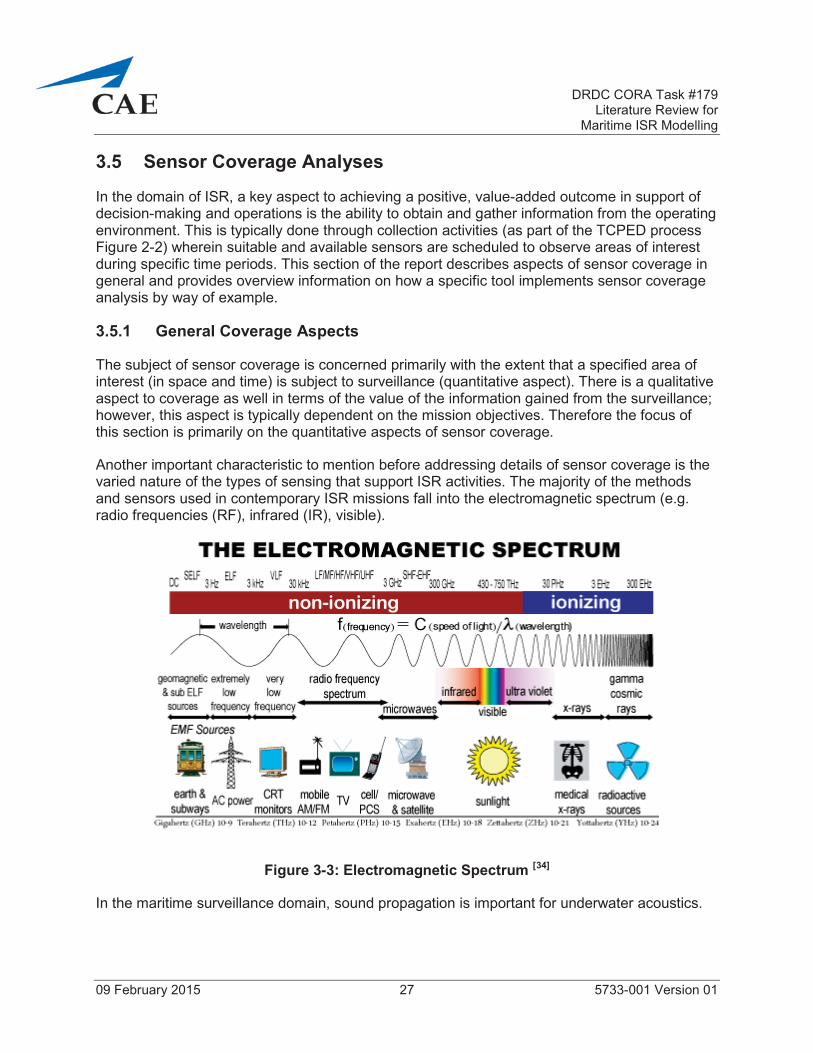
3.5 Sensor Coverage Analyses
In the domain of ISR, a key aspect to achieving a positive, value-added outcome in support of decision-making and operations is the ability to obtain and gather information from the operating environment. This is typically done through collection activities (as part of the TCPED processFigure 2-2) wherein suitable and available sensors are scheduled to observe areas of interest during specific time periods. This section of the report describes aspects of sensor coverage in general and provides overview information on how a specific tool implements sensor coverage analysis by way of example.
3.5.1 General Coverage Aspects
The subject of sensor coverage is concerned primarily with the extent that a specified area of interest (in space and time) is subject to surveillance (quantitative aspect). There is a qualitative aspect to coverage as well in terms of the value of the information gained from the surveillance;however, this aspect is typically dependent on the mission objectives. Therefore the focus of this section is primarily on the quantitative aspects of sensor coverage.
Another important characteristic to mention before addressing details of sensor coverage is the varied nature of the types of sensing that support ISR activities. The majority of the methods and sensors used in contemporary ISR missions fall into the electromagnetic spectrum (e.g. radio frequencies (RF), infrared (IR), visible).
Figure 3-3: Electromagnetic Spectrum [34]
In the maritime surveillance domain, sound propagation is important for underwater acoustics.

DRDC CORA Task #179Literature Review for
Maritime ISR Modelling
09 February 2015 28 5733-001 Version 01
Irrespective of the source being sensed, relevant metrics of interest associated with sensor collection activities include:
Amount (or percent) of the area covered;
Time required to completely cover the area of interest;
Number of assets used / required to cover the area of interest;
Duration of coverage by location;
Gaps in coverage by location and duration; and
Revisit time by location when gaps exist.
In context of the fundamental problem associated with the surveillance and reconnaissance aspects of ISR, the fundamental characteristic of the solution is one of geometry; that is, sensor coverage analysis is fundamentally a geometry problem. Although there are several other factors that come into play for a comprehensive analysis, the geometry aspects are core to any calculations. With this in mind, the key (operationally oriented) parameters associated with sensor coverage analyses include:
Sensor characteristics such as:
o Field of View (FOV) and Field of Regard (FOR): for some sensors, such as an omni-directional antenna, the FOV and FOR are equal; however, for most visual, IR and radar sensors, the FOV is an instantaneous measure whereas the FOR is the definition of the full extents through which the FOV can be positioned (Figure 3-4).
Figure 3-4: Field of View VS Field of Regard [35]
o Scan Rate: for a gimbal-mounted sensor (such as a radar antenna or an electro-optical turret) the angular rate at which the FOV can be moved through the FOR; for radar sensors this is typically expressed in rotations per minute (RPM) or degrees per second.
o Detection Range: the maximum distance from the sensing location at which an emitting characteristic of interest (radar return, electronic emission, temperature differential, contrast ratio) stands out reliably from the background environment noise.

DRDC CORA Task #179Literature Review for
Maritime ISR Modelling
09 February 2015 29 5733-001 Version 01
Platform characteristics such as:
o Operating Altitude: the height above the terrain or mean sea level at which the sensor host platform operates; in some instances, for terrestrial-based platforms such as ships, the height of a mast mounted sensor becomes important due to the height of the mast.
o Operating Speeds: the speed at which the sensor host platform moves over or around the earth.
o Climb, Descent and Turn Rates: the rate at which the sensor host platform is able to change its direction of travel; climb and descent rates are typically expressed in feet per minute (or meters per second) while turn rates are typically expressed in degrees per second or minute.
o Endurance: the maximum amount of time a sensor host platform is able to remain available for a specific reconnaissance activity (e.g. a patrol).
3.5.2 Sensing and Detection Modelling
An important aspect of sensor coverage analysis is taking into consideration the sensing and detecting abilities of the assets being used to support ISR objectives. Tolk describes a set of options that are typically considered for modelling sensing. The choice of which approach to use will depend on several factors including purpose as well as the resources and time available for implementing the model [36].
Perfect sensing – global (all sensors can see everything in the synthetic world – no limitations)
Perfect sensing within sensor coverage areas (sensors can see everything within their defined field of view)
Filtered sensing within sensor coverage areas (sensor, target and environment attributes and interactions are taken into account)
Report-driven sensing (takes into account reliability of source and time-late of information)
Additional details on specific approaches and methods for calculating sensor coverage are contained in subsequent sections of this report as per the information that was available.
In his book focused on combat modelling, Strickland [37] dedicates an entire chapter to detection modelling. He identifies an approach to detection modelling whereby specific pairing of sensors and targets forms the foundation. The implementation of this type of approach usually takes theform of look-up tables wherein the entry arguments can include range to target and aspect (sensor-to-target geometry). The values of detection (probability) will often take the following elements into consideration:
Sensor characteristics, which can be derived from manufacturer specifications or operational tests and evaluations;

DRDC CORA Task #179Literature Review for
Maritime ISR Modelling
09 February 2015 30 5733-001 Version 01
Target characteristics such as material composition and operational profile; and
Environment characteristics such as terrain, atmospheric conditions and ocean characteristics.
Strickland addresses elements a little further along in the TCPED process and states that target acquisition is usually modelled as a probabilistic event on condition that certain physical preconditions are met (line of sight, range, and geometry satisfied) and that detection actually occurs. The author of this report has past experience with the JANUS system and, although it is a somewhat dated application, it operates on the principles described above and has proven effective, in cases, as an operations analysis and research tool.
Based on several items of literature, personal experience and common sense, one can conclude that line of sight (LOS) modelling is fundamental to sensor coverage and detection analyses and that the method/approach chosen for LOS calculation can have a significant effect on the outcome and performance of an ISR model. For example, on-the-fly calculations are computationally intense but have the potential to offer a high degree of detail and fidelity towards a deterministic solution. Alternatively, more computationally efficient methods can be realized through the use of look-up tables that are generated by pre-processing of data within higher fidelity, physics-based models, although this may not be appropriate for all applications or all phenomena.
Perhaps one final aspect to take into consideration when considering the subject of sensor coverage analysis is the notion of risk. Most defence and security scenarios have, as a main aspect or characteristic, an element of risk acceptance or risk tolerance. Therefore, through association, one can suggest that sensor coverage analysis has, at its root, a direct relationship to risk – unless one is fortunate enough to have 100% continuous coverage with the highest degree of probability for detection and identification, which is highly unlikely. Most sensor coverage analysis problems are time-space-position-capability problems; depending on the domain of operation of the sensor platforms, some of these factors are more controllable than others. For example, it is very costly to reposition space-based assets, so the main factors become relatively fixed for a given orbital asset; however, many of the asset risk problems are not as relevant because it takes highly sophisticated technologies and capabilities to counter a space-based asset.
Another risk-related characteristic of sensor coverage analyses includes identification of the “adversary” from an ISR mission or campaign perspective. Is the adversary traditional (i.e. anopposing force) or is the main adversary that faces an ISR capability one of cost, time or someother non-combat-oriented characteristic. Essentially, the question becomes one of what is the primary constraint; quite often this will drive the approach to analyzing and solving the coverage problem.
3.5.3 STK Coverage Description
The System Tool Kit (STK) produced and sold by Analytical Graphics Incorporated (AGI) is a popular and highly used tool in domains such as ISR. More information on STK in general is included in the next main section of the report (which covers several tools and capabilities) but for the purposes of this section of the report a generalized description of how STK addresses

DRDC CORA Task #179Literature Review for
Maritime ISR Modelling
09 February 2015 31 5733-001 Version 01
coverage analysis is included. The intent is not to impart any bias towards STK; rather, the author has past experience using STK and hence understands the general inherent mechanisms for STK sensor coverage analysis and detailed information is readily accessible through the AGI public website [38] under the top-level subject of Analysis Modules. There is also a description of the STK Coverage Module. [39]
Coverage analysis is a means by which one can calculate the quantitative and qualitative aspects of intervisibility between two objects or an object and a location (point, area or volume) on or above the surface of the earth. Coverage analysis covers a broad spectrum of complexity, the extremes of which are characterized by the following examples:
Simple coverage analysis between to point-mass objects based on straight-forward line of sight (simple geometry) computations that take into account only the curvature of the earth ellipsoid model (i.e. no detailed terrain modelling involved). In STK parlance this type of scenario is more along the lines of a simple Access calculation.
Complex coverage analysis between a group of objects (such as a constellation of satellites) that host a suite of complex sensors working together to view an extended volume of space on and above the surface of the earth. The computations can take into account a detailed set of factors and constraints that impede access including the terrain, atmospheric interferences, sensor performance limitations, and other temporal and spatial limitations (of which there are more than 80 in STK).
STK Coverage calculations are facilitated by the creation of two types of objects, which represent the fundamental aspects of performing coverage analysis.
Coverage Definition Object: this object defines the area/volume for coverage, the objects providing coverage (platforms & sensors), the time period of interest, and the access calculations to be included. The area or volume is assigned (manually or automatically) a set of grid points which is used as the basis (from a spatial geometry perspective) for the access and coverage computations.
Figure of Merit Object: this object, of which one or more can be assigned to a Coverage Definition Object, provides a means for defining the measure that will be used to evaluate the quality of coverage. The user needs to set basic parameters including the evaluationmethod, measurement options and satisfaction criteria. Figure of Merit types include:
o Coverage Time;
o N Asset Coverage (number of assets available simultaneously during coverage);
o Number of Accesses;
o Response Time;
o Access Duration;
o Age of Data;

DRDC CORA Task #179Literature Review for
Maritime ISR Modelling
09 February 2015 32 5733-001 Version 01
o Number of Gaps;
o Revisit Time; and
o Time Average Gap.

DRDC CORA Task #179Literature Review for
Maritime ISR Modelling
09 February 2015 33 5733-001 Version 01
4 ISR TOOLS AND CAPABILITIES
Much like there are many different approaches to modelling the ISR space, there have been many different tools developed to facilitate representation, assessment and analysis. In his paper on C4ISR assessment [40] Dr. Starr provides guidance and advice that implies the use of multiple tools in an iterative fashion is a sound approach to a comprehensive assessment and analysis of the C4ISR problem space.
The evidence and information found during the review for this work supports this guidance.Among the tools found and reviewed, no single tool addresses all aspects of the ISR domain space; each tool has its area of focus (emphasis) based on the original sponsor and intended application (recall the fundamental definition of a model).
This part of the report contains information on ISR modelling tools and capabilities that were found during the course of work on this task. There is also a section that identifies other potential sources of information that DRDC CORA may choose to follow up on.
4.1 Tools and Capabilities Discovered
This section of the report contains several sub-sections, each of which provides information on an ISR-relevant tool or capability. The level of detail of the information for each item varies based on what was available in the public domain or what could be obtained direct from source if a point of contact was responsive to queries submitted. Where sufficient information was available, the description is preceded by a table that contains general information about the tool or capability.
4.1.1 System Tool Kit (STK)
Table 4-1: STK Information
System Tool Kit (STK)
Responsible / Owning Agency Analytical Graphics Inc. (AGI), USA
Origin Year / Latest Update 1989 / Current and on-going
Availability Commercial with some export limitations
Cost Varies depending on options selected
Website www.agi.com
Key Characteristics Physics / engineering based, visualization of complex systems and situations
Host System Requirements Windows OS, 2 + GHs CPU, 3+ GB RAM, High-end GPU, NIC

DRDC CORA Task #179Literature Review for
Maritime ISR Modelling
09 February 2015 34 5733-001 Version 01
The System Tool Kit (STK) is the flagship product of Analytical Graphics Inc. (AGI); STK is a physics / engineering level modelling environment used by engineers, analysts and developers to model complex systems commensurate with the defence and security operating environment.One of the primary strengths of STK is its ability to model and visualize, in great detail, dynamic data sets in four dimensions (three dimensional space and time) from the depths of the ocean to the far reaches of space. In STK users are able to model vehicle platforms (satellites, aircraft, ships, vehicles), sensors, communications systems and links, environmental effects, terrain and features, and interactions amongst all of these objects. In addition, with the purchase of specialized add-on modules, users and analysts are able to invoke functions and features that facilitate detailed analysis in the following noteworthy areas:
Communications systems including antenna design (including multi-beam), interference analysis, and link budget analysis (STK Communications);
Radar systems with the ability to define and incorporate radar cross sections of targets (STKRadar);
Coverage of objects, locations, areas and volumes that can take into consideration a variety of pre-configured and user-definable constraints to support computations for several figures of merit depending on the objectives (STK Coverage); and
Complex, highly accurate, time-based mission analysis for aircraft operations leveraging airframe-specific deterministic models (Aircraft Mission Modeler).
In addition to its inherent capabilities, STK is based on an open architecture making it highly extensible and interoperable with custom models and other applications respectively. The AGI website highlights specifically the use of STK for modelling ISR missions, and provides several links to video examples, literature, case studies, white papers and webinars [41].
4.1.2 System Effectiveness Analysis Simulation (SEAS)
Table 4-2: SEAS Information
System Effectiveness Analysis Simulation (SEAS)
Responsible / Owning Agency US Air Force Space & Missile Systems Center / ExoAnalytic Solutions
Origin Year / Latest Update 1992 / Version 3.9 in 2011
Availability Free for US government use including contractors with valid need
Cost Unknown
Website www.teamseas.com
Key Characteristics Agent-based, model complex adaptive systems, 3D visualization
Host System Requirements Windows, Core i7, 4 GB RAM, 5 GB space, 2 + monitors

DRDC CORA Task #179Literature Review for
Maritime ISR Modelling
09 February 2015 35 5733-001 Version 01
The System Effectiveness Analysis Simulation (SEAS) is a constructive simulation tool that enables mission-level military utility analysis primarily in support of acquisition decisions [42].SEAS offers agent-based modelling in a physics-based battlespace, thus combining two of the important aspects described earlier in this report.
The vision for SEAS began in 1992 and version 1 was released in 1994. SEAS was accepted into USAF Standard Analysis Toolkit (AFSAT) in 1999. CAE submitted a request for information to ExoAnalytic Solutions through their website but there has been no response to date.
A RAND report from 2001 entitled Assessing the Value of Information Superiority for GroundForces – Proof of Concept [43], contains a documented briefing on the use of SEAS, which includes considerable detail on SEAS itself and a Correlation of Forces and Means (COFM) model that was implemented within SEAS.
The many appealing features of SEAS include:
Ability to model overhead ISR systems as well as individual battlefield entities;
Ability to incorporate theatre-wide geography;
Simultaneous representation of multiple missions in a theatre context;
Semi-independent autonomous agents; and
Ability to run on a PC platform relatively quickly.
Another RAND report [44] entitled “A RAND Analysis Tool for Intelligence, Surveillance, andReconnaissance: The Collections Operations Model (COM)” introduces COM as it was written for SEAS. The COM is an agent based construct comprised of a suite of modules and libraries that address many aspects of an ISR scenario or environment such as behaviour models, operations models, asset models and the environment.
In 2005 the Aerospace Corporation conducted an ISR investigation using SEAS [45]. The objective was to analyze the military utility of space, air, ground and sea assets. The SEAS system was deemed to be well suited for representing camouflage, concealment and deception methods as well as the concepts of operations for friendly and enemy forces. Key features of the use of SEAS in support of this investigation included:
An object-oriented paradigm;
Use of a Monte Carlo approach to combat simulation; and
Incorporation of autonomous agent behaviours.

DRDC CORA Task #179Literature Review for
Maritime ISR Modelling
09 February 2015 36 5733-001 Version 01
4.1.3 Virtual ISR Evaluation Environment (VIEE)
Table 4-3: VIEE Information
Virtual ISR Evaluation Environment (VIEE)
Responsible / Owning Agency DRDC Ottawa
Origin Year / Latest Update ~ 2008 / ~2013
Availability Government of Canada / DRDC
Cost Not applicable
Website None available
Key Characteristics SOA approach, federated systems, government owned
Host System Requirements Windows, Core i7, 4 GB RAM, 5 GB space, 2 + monitors
The Virtual ISR Evaluation Environment (VIEE) was designed and developed by DRDC Ottawa in collaboration with DRDC CORA. The high-level design approach to the VIEE had four main elements:
Model the systems;
Build the scenarios;
Use exploitation tools to process systems data; and
Use assessment tools to evaluate mission performance.
The underlying architecture is based on service oriented architecture (SOA) approaches wherein there are three main components:
The VIEE Client;
Web Services; and
Modelling & Simulation.
A series of four papers describe and discuss the evaluation approach as well as the design and development of VIEE.
The first paper (NATO MP-SET-130-28 (2008) [46]) provides the basis (approach andmethodology) for evaluating ISR system architectures, which results in the calculation of an overall Measure of ISR Effectiveness (MOIE);

DRDC CORA Task #179Literature Review for
Maritime ISR Modelling
09 February 2015 37 5733-001 Version 01
The second paper (NATO MP-MSG-082-12 (2010) [47]) describes the VIEE design andarchitecture, and provides an example application to space-based surveillance of maritime approaches;
The third paper (Summer Simulation Conference 2010 [48]), jointly written by DRDC Ottawa and Larus Technologies, describes the VIEE design and architecture; and
The fourth paper (International Symposium on the AHP 2013 [49]) describes detail associated with the latest evaluation approach and process associated with the VIEE.
The VIEE architecture is depicted in Figure 4-1.
Figure 4-1: VIEE Architecture [50]
4.1.4 Map Aware Non-uniform Automata (MANA)
Table 4-4 MANA Information
Map Aware Non-uniform Automata (MANA)
Responsible / Owning Agency Defence Technology Agency (DTA), New Zealand (Government)
Origin Year / Latest Update 1999 / Version 4, 2007 / Version 5.0 (V) – status unknown
Availability Government-to-government such as TTCP
Cost Unknown / Not applicable
Website No website specifically for MANA

DRDC CORA Task #179Literature Review for
Maritime ISR Modelling
09 February 2015 38 5733-001 Version 01
Map Aware Non-uniform Automata (MANA)
Key Characteristics Agent-based,
Host System Requirements None formally identified
The following information was extracted from the MANA Version 4 User Manual [51].
MANA is an agent-based distillation model developed by DTA New Zealand; MANA falls within a general class of agent based models, which have entities that are controlled by decision-making algorithms rather than the modeller/user determining behaviour in advance.The distillation aspect reflects the intention to model the essence of a problem rather than specific, discrete aspects.
The creators of MANA identify the challenges that physics-based models have when faced with trying to help analysts assess the value of “intangible aspects such as situational awareness (SA), C2, and the informational edge provided by enhanced sensors”.
MANA was custom designed to model complex adaptive systems for combat situations using cellular automaton approaches; a unique aspect of MANA is the incorporation of a “memory map” which fulfills the functions of providing shared situational awareness and guidance for entities around the environment.
An underlying concept is that physics-based mathematical equations alone cannot predict the unfolding of every-day events with a high degree of certainty mainly because of the varying aspects of nature (the environment and human); as is stated in the manual: “human nature is mathematically intangible”.
The deterministic nature of many, highly detailed physics-based models has the opposite result of what most would expect in that the portrayed behaviours of entities end up being much less intelligent-like than what one would experience in real life.
MANA addresses two key concepts:
o Entity behaviour is a critical analysis component; and
o Physics-based models do not provide the value needed for assessing force mix andeffectiveness.
MANA is not, in itself, a silver bullet; it is not inherently intelligent. Use of the tool requires careful thought during scenario development.
The essence of MANA’s design was to maximize the range of possible outcomes explored;this is characteristic of complex adaptive systems.
Limitations of MANA emerge when looking at the details. MANA is meant to be used from a statistical perspective rather than a discrete, absolute perspective; much can be learned

DRDC CORA Task #179Literature Review for
Maritime ISR Modelling
09 February 2015 39 5733-001 Version 01
from looking at trends across large numbers of runs, as well as outliers (best and worst cases) for assessing strengths and vulnerabilities.
Automaton models generally produce results that tend to align well with real world experiences; most results are similar to the mean, but there are occasional, very noteworthy differences.
Characteristics of MANA include:
o Overall behaviour of the modelled system emerges as a result of many local interactions;
o Inherent inclusion of feedback processes, which typically is not present in other types of models;
o The system being modelled cannot be analyzed by decomposing into simple independent parts; and
o Non-linear interactions giving way to adaptation.
Real-word situations that are a focus of MANA include:
o Importance of sensors and optimizing their use;
o Influence of situational awareness on decision making; and
o Adapting plans as the situation evolves.
Key concepts of exploration for which MANA was designed:
o Situational awareness;
o Communications (between groups of entities);
o Use of terrain features (e.g. roads and concealment);
o Waypoints; and
o Event-driven personality changes (e.g. exchange of fire).
MANA was used by Liang to complete work in support of a thesis entitled “The Use of Agent Based Simulation for Cooperative Sensing of the Battlefield.” [52] MANA was used to support the study of cooperative sensing for ISR purposes. The following are some noteworthy aspects.
MANA can be referred to as an agent-based, scenario exploring model wherein entities are controlled by internal decision-making algorithms.

DRDC CORA Task #179Literature Review for
Maritime ISR Modelling
09 February 2015 40 5733-001 Version 01
MANA is considered a distillation model in that it models the essence of a problem rather than every aspect in detail; this way, the model is able to run faster to provide for rapid, repeatable concept exploration.
MANA was designed to analyze the value of situation awareness, C2 and the informational edge – something that is limited in highly detailed physics-based models.
MANA was also used by a cohort team at the Naval Post-graduate School (NPS) for its team project (NPS Cohort 20 Team Bravo, 2014) [53] focused on a Distributed Air Wing concept,which included ISR as one of the critical capabilities. The work in this project used a variety of modelling approaches and tools including IDEF0 (a function modelling method designed to model the decisions, actions and activities of an organization or system [54]), Monte Carlo simulation, integer linear programming, and MANA. Following are elements of this work worth noting.
MANA was used to generate a stochastic, discrete event simulation of the ISR concept of operation; specific desirable attributes of MANA related to the team’s work included:
o MANA provides capability to model several different entities that can operate both individually and in squads;
o MANA has the ability to model sensors – specifically both detection and identification ranges;
o MANA can model communication links where entities can provide situational awareness to other entities; and
o MANA is capable of modelling weapons, specifically the probability of hit.
Results from the analysis using MANA were compared to a straight-forward search theory analytic model; the output was deemed useful in context of informing procurement and employment decision making.
The NPS team project report is extensive (in excess of 300 pages) and was supported by a large team of personnel from the United States Navy and Singapore.
4.1.5 C4ISR Analytic Performance Evaluation (CAPE)
CAPE is a methodology that has its origins in the 1980s when MITRE was developing a collection of techniques for modelling system performance. The name CAPE was coined in 1997 to denote the modelling methodology being used by MITRE analysts in C4ISR studies.
MITRE published an extensive paper on the CAPE architecture in March 2000 [55]. A CAPE webinar by Henry Neimeier in October 2008 [56] identifies, as an element of the CAPE Concept that it should “execute on a portable in less than 5 minutes” to provide “real time decision support”. From the same webinar, CAPE is indicated as having the following characteristics:

DRDC CORA Task #179Literature Review for
Maritime ISR Modelling
09 February 2015 41 5733-001 Version 01
Simulates simply (fixed time step whereby inputs for next time step are outputs from previous);
Represents uncertain environments using probability distributions; and
Simple analytic calculations (no random number generation or sampling)
CAPE was implemented in Analytica™ on a personal computer and makes use of analytic queuing as an alternative to discrete event simulation. The last slide of the webinar [57] lists 15 application examples of CAPE.
4.1.6 Valuing Persistent ISR Resources (VPR) System
George Mason University and NPS developed a prototype system to support a study on generating a methodology for allocating persistent ISR assets in order to maximize the ability to detect and report [58]. Elements of the approaches and methods used are described earlier in this report.
The VPR prototype system consisted of the following:
MS Excel and ArcGIS for input control and pre-processing of input data such as asset quantities, COIs values, operating bases, terrain type, distances, the threat and line of sight indicators;
MS Excel for additional pre-processing of the full input data set to generate an expected assignment value table for location adjusted COIs, the threat and terrain-adjusted detection probabilities ;
A MPL / CPLEX Solver for optimizing asset assignments and calculating the constrained expected PISR value;
MS Excel for tabulating the MPL / CPLEX output, calculating PISR and coverage ratios, and generating asset-location assignment pairs; and
ArcGIS for map based display and visualization of all aspects.
Based on experiments that were conducted, the methodology and prototype system implemented are deemed suitable and practical for problems of reasonable size:
To deploy existing assets;
To prioritize acquisition of additional assets;
For rapid modification of allocations to support agile deployment; and
For rapid procurement to meet changing conditions.

DRDC CORA Task #179Literature Review for
Maritime ISR Modelling
09 February 2015 42 5733-001 Version 01
4.1.7 Dynamic Course of Action Decision (DCOAD) Tool
The DCOAD tool was developed through a combined effort between BAE Systems and the USAF Air Force Research Laboratory (AFRL) with the objective of generating a predictive battlespace awareness capability for time sensitive targeting (TST) [59].
DCOAD works at the target level and generates battlespace predictions for presentation in the form of probabilistic maps. The predictions that are generated fall into one of four categories:
TST Occurrence;
Strike Coverage;
Composite Models; and
ISR Coverage.
In the ISR Coverage category, instantaneous sensor coverage is a circular footprint for all ISR assets and sensor performance includes the effect of terrain by way of a constant calculated using a logistic curve function.
From a software architecture perspective, DCOAD is open in that it allows estimators (algorithms) to be developed and plugged-in. This provides a means for rapid estimation update when used in operational environments.
Practical, easy to interpret and unique probabilistic overlays were developed to facilitate visualization of predictive battlespace awareness.
DCOAD also incorporates a novel approach to terrain masking calculations in support of ISRestimations. This approach uses a terrain variability parameter and the concept that target acquisition and tracking are more difficult in more variable terrain. Based on this approach, a heuristic was derived to vary the probability of ISR coverage based on terrain variability in the scenario area. The result is the ability to compute output in near real-time; however, it is important to note that at the time of the referenced report, the heuristic was not developed with empirical data nor had it been validated.
4.1.8 Joint Theater Level Simulation (JTLS)
Table 4-5: JTLS Information
Joint Theater Level Simulation (JTLS)
Responsible / Owning Agency Rolands and Associates
Origin Year / Latest Update 1983 / Current version 4.1.7 / Version 5.0 anticipated June 2015
Availability Commercial

DRDC CORA Task #179Literature Review for
Maritime ISR Modelling
09 February 2015 43 5733-001 Version 01
Joint Theater Level Simulation (JTLS)
Cost Rough order of magnitude price is $600,000
Website http://www.rolands.com/jtls/j_over.html
Key Characteristics Mainly aggregate, operational level modelling; unit awareness intelligence modelling
Host System Requirements Information available at: http://www.rolands.com/jtls/j_equip.html
The information provided on JTLS is sourced from a combination of the JTLS website [60] and an email received direct from the company president on 15 January 2015.
JTLS is a sophisticated operational level system that models several aspects of multi-sided air, land and sea operations. JTLS began development in 1983 and received initial fundingthrough various US Army based initiatives. JTLS has grown to become one of the premiere operational level modelling systems in the world today. JTLS is currently used by more than 20 nations and international organizations world-wide.
JTLS runs on Commercial off the Shelf (COTS) hardware. It has some COTS software dependencies depending on the specific end-user needs and configuration. JTLS is well document (20 manuals and user guides).
An important feature is the ability for JTLS to be interfaced with real-world C2 systems.
The following is the ISR-specific content of the email received directly from Rolands (underline emphasis provided by the author of this report based on context and objectives):
I cannot say that we have ever done a specific scenario for ISR, but JTLS has a full ISR module that is used in almost every exercise that is conducted with JTLS. Specifically, the following is represented:
In JTLS we have the following assets that can collect intelligence information:
o Satellite - Imagery, IR, and ELINT [Electronic Intelligence] - this is a national level asset and is not owned by the theater commander within JTLS. This means that the JTLS controller decides where and when the satellites cover the area. JTLS comes with an orbital mechanics program in which you place Two-Line Entry (TLE) data for one or more satellites and it computes when the satellite is over the game board. In JTLS 5.0 (which is under development), the model tracks the satellite throughout its full orbit -since JTLS 5.0 has gone global and no longer has a game board.
o Air breathing assets - these are considered theater assets and the air staff needs to decide where these assets will fly as part of the daily Air Tasking Order [ATO]. More about this later in this e-mail.

DRDC CORA Task #179Literature Review for
Maritime ISR Modelling
09 February 2015 44 5733-001 Version 01
o Targets - Radars and sonars are specifically represented also. This is primarily used for naval collection, but also is used to represent land-based assets such as an airbase's air search radar. Any unit in the game can be given a sensor target. This may be a radar or a sonar, but it could also represent the bridge lookout and would then be given a sensor of imagery. Any sensor site target can detect anything that falls within its circular area of coverage. Types of sensors are: surface search, air search, counter-battery radars, ELINT, sonars, and passive sonars.
o Unit awareness intelligence. Each unit in the game is aware of what is happening around it. Although we do not specifically model unit patrol, there is a database parameter indicating how far this awareness "Bubble" extends beyond the unit footprint. As a database parameter, it is up to the scenario builder how large or small this awareness bubble is.
o Special Operation Force (SOF) Recon Teams. JTLS fully supports the emplacement and recovery of SOF teams and while out on patrol in either a covert or non-covert nature, they collect intelligence. This human collected intelligence is saved until the team is assigned to report. The modeled team holds a list of Essential Elements of Information (EEI) for which they will break radio silence and immediately report what they are seeing - such as a SCUD launcher preparing or in a prepared to fire mode.
No matter what collects the information, the database indicates the types of delays on getting this information to an intelligence collection center. When it arrives, the user is informed and the information provided to real-world systems. JTLS models the fusion of this information and it is time based. The time required to fuse is contained in the database.
Going back to the air breathers. An Air Tasking Order (ATO) tells a reconnaissance asset where to fly but not where to look. The user can set up the scenario in such a way so the mission looks where ever it wants or you can make the exercise audience play the full intelligence collection requirement and have the commander outline what type of information he wants and have the exercise audience create a real world daily collection deck. Once a collection deck is created and entered into the model, again you have an exercise design choice. You can assign each collection deck items to a specific mission or satellite or you can have the model assign them in a reasonable manner for you.
We play partial detections based on the collection capabilities of each asset. There are four levels of detection represented:
o Localization - location only - ship at this location
o Classification - basic type of object - large container ship
o Recognition - detailed type of object – liquid natural gas (LNG) container ship
o Identification - exact object name = The Kobayashi Maru LNG container ship

DRDC CORA Task #179Literature Review for
Maritime ISR Modelling
09 February 2015 45 5733-001 Version 01
The ability to go from one detection level to another depends on the sensor characteristics and how close the collector is to the object being detected. This is both in distance and altitude (slant distance).
Concerning a scenario with Naval ISR. Again, we have never had a specific scenario that concentrated only on the Navy, but the following specific naval ISR capabilities are used within ever joint, coalition exercise that we run. Naval ships have sensor targets and Link-16 capability. They detect things and report according to the four detection levels discussed above. We automatically generate a full and correct Link-16 surface picture and air picture.
4.1.9 Naval Simulation System (NSS)
The following information on NSS was taken mainly from a series of pages at the Metron Scientific Solutions website [61]; other specific sources of information are indicated as appropriate.
NSS does force-on-force modelling at the individual platform, weapon, sensor and C3 system level.
NSS is capable of representing C4ISR (among other aspects) for multiple players at varying levels of resolution.
The OASiS Division (Operational Analysis and Simulation Sciences) of Metron Scientific Solutions developed NSS [62].
o The Division works directly with Office of the Chief of Naval Operations (CNO) and the Space and Naval Warfare Command (SPAWAR).
o They provide on-site operational support to Commander of the Pacific Fleet (COMPACFLT) and Navy Warfare Development Command (NWDC) in assessing alternative courses of action for fleet operational contingency plans employing NSS.
There is a larger suite of tools known as the NSS Toolkit – two specific components of interest are:
o TIGER (Target Input Generation Estimator)
A general purpose track management tool which calculates a sequence of detection events
Provides time-phased input data to PUMA to generate realistic data flows to support a range of ISR analyses
o PUMA (PED Utilization Model and Analyzer)
PED = Process, Exploit, Disseminate
A discrete event model that allows examination of the PED process

DRDC CORA Task #179Literature Review for
Maritime ISR Modelling
09 February 2015 46 5733-001 Version 01
Platform specific data flows derived from OPNAV N2N6 technical baselines
Accounts for communications bandwidth limitations and incorporates work force, exploitation times and operator/tool performance
4.1.10 Joint Platform Allocation Tool (JPAT)
The following information on JPAT was taken from a NPS thesis [63]; the title of the thesis was “Robust Optimization in Operational Risk: A Study of the Joint Platform Allocation Tool”.
JPAT was developed for the US Army, through a combined effort by Training and Doctrine Command Analysis Center (TRADOC) and NPS, to support decision making in resource management, procurement and operational employment of ISR assets. JPAT is a mathematical model implemented in the Generic Algebraic Modeling System (GAMS) and is “currently used to evaluate the strategic implications of cost, sensor performance, mission requirements, and production timelines to produce optimal procurement and assignment schedule of aerial reconnaissance and surveillance assets.”
As per a Department of the Army memorandum from 20 November 2012 [64] JPAT was designated the winner of the Army Modeling and Simulation Award in the category of Analysis.
Very little additional information was available on JPAT in the public domain other than twoNPS theses, even at the US Army TRADOC website.
4.1.11 Joint Dynamic Allocation of Fires and Sensors (JDAFS)
The following information on JDAFS is sourced from a NPS thesis [65].
JDAFS is a tool that was developed by US Army TRADOC based on an earlier version of the tool known as DAFS, which was originally developed by TRADOC Analysis Center Monterey, NPS for use in scenario-based, exploratory analysis, primarily in support of the US Army’s Future Combat System. JDAFS enables analysis of many scenarios and factors to explore Joint ISR missions through low resolution discrete event simulation. The JDAFS framework is programmed in JAVA and incorporates functionality of Simkit, a collection of JAVA libraries that support implementation of event graphs, created by Dr. Arnold Buss of the Modeling, Virtual Environments and Simulation (MOVES) Institute at NPS.
Event graphs are deemed uniquely suited to describe and implement types of movement, sensing and weapon effects interaction for low resolution simulation. A primary advantage of event graphs, when compared to a time stepped approach, is improved model run time.
When provided with a scenario and a mix of ISR platforms, JDAFS optimizes a flight schedule and executes the missions. To accomplish this it considers the following elements:
o Low resolution airframe operational parameters (not flight characteristics)
o Sensor payload capabilities

DRDC CORA Task #179Literature Review for
Maritime ISR Modelling
09 February 2015 47 5733-001 Version 01
o Base and mission area locations
o Line of sight inputs
JDAFS inputs consist of an Extensible Markup Language (XML) file that is generated from an Access database of parameters. The main items of output in the form of tables include:
o Acquisition (target)
o Coverage / Coverage by Type / Coverage Delay
o Killer-Victim Scoreboard
o Mission Assignment
o Run Information
o Schedule
Freye’s thesis report contains unclassified data for several platforms (maximum altitude, speed and endurance) and sensors that were used for the study – the platform information source is indicated as a variety of open source references while the sensor performance parameters (range) appear to be arbitrary.
JDAFS is capable of running on standalone laptop or desktop platforms but this is only considered practical for fewer than hundreds of simulations.
o The NPS student used a cluster of 12 PCs (note that JDAFS was not designed to run on clusters meaning modifications were required to make this work)
o 274 runs took 4 hours of processing
o 2740 runs took 60 hours of processing
Very little additional information was available on JDAFS in the public domain beyond studies that have been done by educational and research institutions, even at the US Army TRADOC website.
4.1.12 Larus Technologies
The following information was received from the President of Larus Technologies, George Di Nardo, on 15 December 2014.
Company Overview
Larus Technologies Corporation is a wholly-owned Canadian engineering and software development company. Larus is Ottawa-based with three core business areas, Decision Support Systems using Predicative Data Analytics, Software Engineering Consulting, primarily

DRDC CORA Task #179Literature Review for
Maritime ISR Modelling
09 February 2015 48 5733-001 Version 01
in the public security and defence sector, and Research and Engineering, focusing on innovations in computational intelligence, behavioural analytics and data fusion. Larus Technologies is known for its expertise in developing solutions and advanced systems for multi-sensor data collection, aggregation, display, exploitation and fusion.
Larus has developed extensive capabilities in developing defence/security applications, intelligent systems and engineering simulations. Larus has unique technical and research expertise in defence/security applications, intelligent systems and engineering simulations and an excellent reputation with clients and technology partners including Canadian Forces, DRDC, Canadian Space Agency, NATO, Inmarsat International and others.
Simulation and Modelling
Larus has developed expertise in the use and development of various third-party and in-house developed simulation and modelling tools and software. These include the DRDC-Ottawa SIMLAB Simulation software system, the ONESAF and JSAF constructive simulators, the AGI System Tool Kit (STK) software application and the Larus Scenario Tool (LST). For DRDC Ottawa Larus Technologies was involved in the development of advanced Measures of Effectiveness (MOE) and Measures of Performance (MOP) for the evaluation of ISR Structures with baseline sensors augmented by Space Based Radar Ground MTI (GMTI) sensors using the DRDC SIMLAB facility. As part of the study Larus personnel extended SIMLAB to support new sensor models and capabilities. The study examined the Kill Cycle within a simulated ISR structure. The study was documented in a DRDC Technical Memorandum: R. Jessami-Zargani & Moufid Harb, “Experimentation of the Role and Effectiveness of Space Based Radar (SBR) in Intelligence, Surveillance and Reconnaissance (ISR) Architecture”, TM 2007-291 Report, November 2007. Larus has, by working with different simulation technologies, developed extensive in-house capability in Distributed Interactive Simulation (DIS) and High Level Architecture (HLA) for real-time distributed simulations and has developed gateways and interfaces to interface HLA based simulators with DIS, and specifically for the DRDC SIMLAB simulation system.
In support of an awarded Defence Industrial Research Project (DIRP) for Maritime Domain Awareness Analytics, Larus Technologies further developed its in-house LST simulation and modelling capabilities to enable the testing and verification of its analytic engine in the C4ISR domain. The internally developed, LST provides a framework and functionality for simulation in a number of domains and is able to interface with other DIS based constructive simulators. LST has been extended to support the modelling and simulation of different platforms and sensors, with variable resolution, for both batch and real-time distributed processing. The LST is component drive providing flexibility and easier development and integration of sensor and platform models, and their behaviours, enabling LST to be tailored for specific simulation requirements.
The LST has been developed and currently supports:
Automatic Identification System (AIS) transmitters and receivers, both terrestrial and space based

DRDC CORA Task #179Literature Review for
Maritime ISR Modelling
09 February 2015 49 5733-001 Version 01
AIS interjection of anomalous behaviours into live streams (AIS Spoofing, Dark targets, etc) as National Marine Electronics Association (NMEA) messages
RADAR sensor models, surface, air and space based. Specifically developed models for the Raytheon High Frequency Surface Wave Radar (HFSWR)
RADAR sensor models are able to output Standardization Agreement (STANAG) 4607 and NMEA compliant messages to excite downstream exploitation system and inject anomalous behaviours into live streams
Platform models and behaviours, surface, air and space
Interfaces and interacts with the One Semi-Automated Forces (ONESAF) constructive simulation tool
Supports distributed simulation through DIS
As an AGI Technology partner, Larus has developed a radar model extension allowing STK to generate STANAG 4607 format compliant radar detections. This extension was developed to support all STK radar classes and platforms and extends the STK radar models to provide more realistic radar detections. This extension is a Larus owned product and available through the AGI marketplace.
4.1.13 Fusion Oriented C4ISR Utility Simulation (FOCUS)
The Fusion Oriented C4ISR Utility Simulation (FOCUS) is a tool created by the United States Army Material Systems Analysis Activity (AMSAA) for ISR studies. FOCUS “models C4ISR processes, sensor scanning and performance, terrain, weather, environmental features, man-made features, battlespace factors, improvised explosive devices (IEDs) and organizational elements to simulate performance in an operational context.” [66] FOCUS uses physics-based approaches, including radio frequency range equations, for modelling probability of detection.
The United States Army Task Force ODIN in Afghanistan made use of FOCUS to support operations. FOCUS is also used extensively by the Army Test and Evaluation Command (ATEC).
A somewhat unique or innovative feature of FOCUS is that it incorporates a mode of gaming.This allows user to account for Processing, Exploitation and Dissemination (PED) processes.Users of FOCUS have reported that the tool more closely matches reality by facilitating the investigation of questions that a decision maker may have about effectiveness of a system-of-systems.

DRDC CORA Task #179Literature Review for
Maritime ISR Modelling
09 February 2015 50 5733-001 Version 01
4.2 Other Potential Information Sources
In addition to the tools and capabilities identified above, CAE found other agencies and vendors for which indication was found that an ISR modelling capability or product existed. A query was submitted to these agencies and vendors either through email or via on-line forms but minimal or no responses were provided during the course of this work. This information is provided in the event DRDC wishes to follow-up on any of these potential sources of information.
4.2.1 DRDC Atlantic and Canadian Forces Maritime Warfare Centre (CFMWC)
CAE contacted the Maritime Information Warfare Concepts and Plans group of DRDC Atlantic as well as the Maritime Modelling and Simulation Coordination Office within CFMWC, asking for information on any activities being done related to ISR modelling. The purpose and scope of CORA Task 179 was explained to provide context and justification. CAE added to the query by indicating that activities involving the Ship Air Defence Model (SADM) and ODIN (an underwater warfare modelling package) might be applicable.
DRDC Atlantic indicated that CFMWC representatives would be better suited to provide information related to SADM and ODIN. There was no further indication from DRDC Atlantic regarding specific ISR modelling activities, tools or capabilities – simply some general information regarding integration and federation of tactical level systems not related to ISR.DRDC Atlantic did comment that they suspect any CGF tool that has gone to a full three-dimensional earth centred view would like have (or soon have) the ability to model satellites.
CFMWC indicated that their current main focus is on engagement modelling and providing support to Coalition Attack Guidance Experiments (CAGE) that are run through Canadian Forces Warfare Centre (CFWC) in Shirley’s Bay. They also indicated that they were too heavily engaged in currently mandated work to provide additional information related to this request.
4.2.2 Canadian Forces Warfare Centre (CFWC)
CAE contacted the Warfare Centre Sciences (WCS) Team Leader and the JointExperimentation and Training Team (JETT) Branch Head at CFWC, asking for information on any activities being done related to ISR modelling. The purpose and scope of CORA Task 179 was explained to provide context and justification. A response was received indicating that time was not readily available to be spent on this request due to higher priority engagements. Further response was not received.
Through other work, CAE believes that some of the experimentation activities conducted within CFWC may have relevance to the domain of ISR and ISR modelling.
4.2.3 Center for Naval Analysis (CNA) Corporation
During early discussions, the Task TA indicated that CNA may prove to be a valuable source of information. CAE conducted an initial investigation of CNA through their website (www.cna.org)and for any associated documentation or literature. CAE then sent an email to the general inquiries email address ([email protected]) and to Mr. Stephen Broyhill ([email protected]) who

DRDC CORA Task #179Literature Review for
Maritime ISR Modelling
09 February 2015 51 5733-001 Version 01
was listed as the Business Development point of contact. CAE provided a general description of the objectives of Task 179 and pointed out that the Advanced Technology & Systems Analysis (ASTA) Team of CNA made mention of work in the area of intelligence, information and networks on their web page.
Mr. Broyhill responded the same day indicating that he would forward my inquiry to Mr. Keith Costa, Vice President of the ASTA Division. No further communication was received from CNA.
4.2.4 MITRE
MITRE is well known as a credible source of information in many areas related to defence and security. During review of some of the literature found for this task, the author of this reportcame across the name Russell Richards associated with some ISR research. Further searching generated little more than a LinkedIn profile. After achieving contact with Mr. Richards through LinkedIn, he sent an email direct to CAE.
Mr. Richards indicated that he was indeed involved with ISR modelling and analysis while he was at MITRE but that it was quite some time ago and his “memory is pretty fuzzy since” he has been retired since 2008. Nonetheless, Mr. Richards did identify Mr. Roy Evans ([email protected]) as the best person to contact regarding C4ISR modelling and analysis, if Mr. Evans is still at MITRE. CAE was not able to follow up on contacting Mr. Evans due to time constraints and deadlines.
4.2.5 Interdepartmental Marine Security Working Group (IMSWG)
The author of this report thought it worthwhile to investigate if there wold be any relevant information in the domain of Canadian Public Safety and Security (PS&S). CAE does a significant amount of work in support of PS&S, and through internal connections the author of this report was able to establish a potentially relevant initial point of contact. A member of CAE had previously done work with the IMSWG and he contacted the former IMSWG team lead, Mr.Allan Bartley. A prompt reply was received from Mr. Bartley who informed us that the IMSWG Secretariat was now being led by Mr. Ray Clark ([email protected]) and Mr. Bartley was kind enough to include Mr. Clark on his email reply. Mr. Clark did not reply to the email sent by Mr.Bartley and CAE did not have an opportunity to pursue any follow-up with Mr. Clark during the course of this work.
It may prove worthwhile for DRDC to follow-up with IMSWG through an interdepartmental request or otherwise. Some additional high level information may be available through https://www.tc.gc.ca/eng/marinesecurity/partnerships-285.htm.
4.2.6 Naval Postgraduate School (NPS)
The United States Navy NPS was identified early-on in this work as a highly probable source of very relevant information. Indeed, CAE was able to find several sources of literature on the topic of ISR modelling that originate in NPS. Nonetheless, CAE thought it worthwhile to make contact directly with a current staff member of NPS in an attempt to obtain up-to-date information on the subject.

DRDC CORA Task #179Literature Review for
Maritime ISR Modelling
09 February 2015 52 5733-001 Version 01
A current colleague of the author of this report is a graduate of NPS; this individual was the source of contact information for the former Director of the MOVES Institute at NPS(www.movesinstitute.org), a Commander (USN retired) Joe Sullivan. CAE contacted Mr.Sullivan and provided the context and objectives of Task 179. Mr. Sullivan indicated that he was no longer the Director MOVES but he did identify his successor and included him on his email reply: one Dr. Imre Balogh ([email protected]). Dr. Balogh did not respond to the original email or a follow-up email sent by CAE direct to Dr. Balogh.
4.2.7 Institute for Defense Analyses (IDA)
During one of the general searches for ISR and ISR modelling information, the author of this report came across the Systems and Analyses Center of IDA where their website (https://www.ida.org/en/SAC/ExploreSACResearch/2/RACEvaluatingISR.aspx) indicated the existence of research and analytical capabilities for evaluating ISR issues. An information request was sent to a general information contact email address, but no reply was received.There is potential value in investigating IDA further as one of the top-level topics on their website is “Analyses of Airborne ISR Force Mix”.

DRDC CORA Task #179Literature Review for
Maritime ISR Modelling
09 February 2015 53 5733-001 Version 01
5 DISCUSSION & SUMMARY
This section of the report provides some discussion on the material covered in this report in the form of points of reflection as well as a summary of the work that was accomplished.
5.1 Discussion
The focus of this task had two main components: the operational domain, which was ISR related to coastal maritime domain awareness; and, the modelling of that domain.
As was seen in the definitions provided for ISR and its individual components (Section 2.2), the realm of ISR itself is multidimensional and vast. ISR has the potential to cover the full spectrum of warfare as well as touching or involving several different agencies from many branches of government. The assets that support ISR objectives span a broad spectrum: an ISR asset can be a multi-billion dollar space-based surveillance constellation; it can be an individual’s eyesand ears; or, it can be many things in between. The information relevant to ISR objectives could be from months or years of data collection over a vast geographical area or it could be intelligence as simple as a spoken phrase from a key individual.
Equally complex is the domain of modelling and simulation. In fact, some consider the M&S domain to involve complexities above and beyond the domain of study (whether ISR or otherwise). A main reason for this is that critical decisions must be made regarding the relevancy of characteristics and aspects of the study domain to the objectives being supported by the model or simulation. This is why it is important that any efforts to design, develop or use M&S should always involve experts from both the domain of study as well as M&S experts.
Recall that a model is a fit-for-purpose representation and hence will inherently have missing elements (gaps) when compared to the real world referent. One may ask: “Why not just use the real world system as the ‘model’ so that the highest assurances of completeness and accuracy can be made?” Typically, this approach would be cost or resource prohibitive. However, quite often, as is the case for ISR, the real world domain is so complex that simplification (through abstraction) is necessary to facilitate study of the aspects that are important to the objectives at hand. Indeed it was seen in the presentation of information related to Bayesian approaches as well as the MANA modelling tool that sometimes significant simplification, when applied appropriately, can open the door to insight that is much deeper than if one had created a highly detailed, high fidelity model of the system or capability under study.
Earlier in this report, the view was presented that ISR is a capability and that a true capability consists of people, processes and tools or technologies. Without any one of these elements the required or intended capability will at best break down or simply cease to exist. Therefore, in any efforts to model an ISR capability for a particular objective, one must, at least in the first instance, consider all three elements (people, processes and tools or technologies) even if two of the three are eventually considered irrelevant for the modelling purpose at hand.
One could argue that in the domain of ISR, many people would default to focusing on the tools or technologies element of the full capability as an immediate reaction to a query or investigation regarding simulation of the domain. This is not necessarily surprising in this day

DRDC CORA Task #179Literature Review for
Maritime ISR Modelling
09 February 2015 54 5733-001 Version 01
and age of increased emphasis on technologies and how they can (potentially) improve the effectiveness and efficiency of operations. It is reasonable to anticipate that the average personwould not immediately assume that an ISR capability has a cognitive aspect as well as a dependency on a set of processes in order to be considered successful.
The information and evidence gathered and reviewed during the course of this work supports these statements. Although the majority of the information related to modelling approaches and tools for ISR was focused on technology aspects (such as platforms and sensors), there were examples that demonstrated a need for consideration of the “softer” aspects of ISR. In fact, the agencies and organizations that were primarily concerned with the human and process aspects of ISR, adopted approaches that significantly simplified the modelling of technical aspects in order to best support their objectives. In such cases, platform and sensor performance characteristics were reduced to simple probability distributions in favour of focusing more effort on decision-making algorithms and model performance to facilitate Monte Carlo simulation approaches for generating statistically oriented results.
A parallel can be drawn between some of the ideas related to focus and emphasis in the ISR domain and the domain of interoperability as related to networked, distributed simulation.Current distributed simulation for training in military contexts has its origins in efforts put forth by the Defense Advanced Research Projects Agency (DARPA), industry and the US Army in 1981[67]. Since then, the majority of research, development and implementation effort has focused onthe technical and syntactic aspects of ensuring disparate and distributed simulation systems could be integrated. Relatively little emphasis was put on ensuring alignment amongst purposes, concepts and semantics of the various agencies and systems. Several items in the ISR modelling literature that were reviewed during this work provided a similar sentiment in that most effort and emphasis seems to have been on developing representations of the systems and sensors associated with ISR. Only relatively recently have both of these domains acknowledged that a balancing activity is needed whereby an increase in effort on the non-technical aspects is required. In the case of distributed simulation, more effort is needed in developing awareness, approaches and techniques to ensure alignment exits from conceptual, practical and semantic perspectives. In the world of ISR modelling, recently there has been increased interest in modelling the characteristics related to the value of information and how the data and information that is gathered gets processed, exploited and disseminated.
Another important aspect to discuss that also has similarities to the domain of M&S for military training is the suggestion that the ISR modelling requirements of defence and security organizations cannot be satisfied by a single model or simulation.
From a fundamental perspective, the following logic is presented. One of the strongest supporting elements for this suggestion is the broadly accepted definition of a model: a representation for a purpose. The purposes for which an individual or agency may study the domain of ISR through M&S abound: concept development, acquisition, manufacturing, training, operations and disposal. Therefore, the output or product from a model developed to support one specific focused activity has a high potential of missing aspects or characteristics that would be important to another specific focused activity. For example, an ISR model supporting a procurement program is likely to favour a cost characteristic over a human-machine interface characteristic. However, the human-machine interface is likely to be more important to an ISR training simulation, whereas cost is less important because of the potentially high cost of

DRDC CORA Task #179Literature Review for
Maritime ISR Modelling
09 February 2015 55 5733-001 Version 01
training with the operational system. The bottom-line argument is that there is high probability that a single model or simulation will not meet all of the ISR modelling requirements for an organization, thus resulting in the need to consider acquisition of a suite of M&S tools that cover the broad spectrum of requirements. Essentially, an organization must be willing to consider,investigate and invest in several options to achieve highest success.
5.2 Summary
This task was given the mandate to investigate literature and information available related to ISR modelling in support of DRDC CORA MARPAC Operational Research Team objectives. In an effort to provide context through a building-block approach, this report began by defining and describing the domains of modelling, ISR and the relevant maritime environs. The remainder of the report took the information that was gathered and reviewed during the investigation of the literature and summarized it into two main parts: a chapter on modelling ISR; and, a chapter on ISR tools and capabilities.
The chapter on modelling ISR covered general aspects followed by sections on fidelity, characteristics, attributes, approaches and methodologies as related to ISR modelling. There was also a section specifically focused on sensor coverage analysis due to its significance incontext of support to operational activities.
The chapter on ISR tools and capabilities contains two main sections: a section on the tools and capabilities for which some detailed information was available; and, a section that identifies other potential information sources that were not fully responsive during the time allotted for the conduct of this task.
The final chapter of this report contains a high-level discussion that places the information reviewed during this task into context, providing some thoughts and ideas for further reflection.

DRDC CORA Task #179Literature Review for
Maritime ISR Modelling
09 February 2015 56 5733-001 Version 01
6 ACRONYMS AND ABBREVIATIONS
Table 6-1 Acronyms and Abbreviations
Acronym DefinitionAFRL Air Force Research LaboratoryAFSAT USAF Standard Analysis ToolkitAGI Analytical Graphics Inc.AHP Analytical Hierarchical ProcessAIS Automatic Identification SystemAMSAA Army Material Systems Analysis ActivityASTA Advanced Technology & Systems AnalysisATEC Army Test and Evaluation Command ATO Air Tasking OrderBN Bayesian NetworkC2 Command and Control
C4ISR Command, Control, Communication, Computers, Intelligence, Surveillance and Reconnaissance
CAGE Coalition Attack Guidance ExperimentsCAPE C4ISR Analytic Performance EvaluationCFMWC Canadian Forces Maritime Warfare CentreCFWC Canadian Forces Warfare CentreCGF Computer Generated ForcesCNA Center for Naval AnalysisCNO Chief of Naval OperationsCOBP Code of Best PracticeCOFM Correlation of Forces and MeansCOI Condition of InterestCOM Collections Operations ModelCOMPACFLT Commander Pacific FleetCORA Centre for Operational Research and AnalysisCOTS Commercial off the ShelfDARPA Defense Advanced Research Projects AgencyDCOAD Dynamic Course of Action DecisionDIRP Defence Industrial Research ProjectDIS Distributed Interactive SimulationDRDC Defence Research and Development CanadaDTA Defence Technology AgencyEEI Essential Elements of InformationELINT Electronic Intelligence

DRDC CORA Task #179Literature Review for
Maritime ISR Modelling
09 February 2015 57 5733-001 Version 01
Acronym DefinitionFOCUS Fusion Oriented C4ISR Utility SimulationFOM Figure of MeritFOR Field of RegardFOV Field of ViewGAMS Generic Algebraic Modeling SystemGMTI Ground MTIHFSWR High Frequency Surface Wave RadarHLA High Level ArchitectureIDA Institute for Defense AnalysisIED Improvised Explosive DeviceIMSWG Interdepartmental Marine Security Working GroupIR InfraredISR Intelligence Surveillance and ReconnaissanceJDAFS Joint Dynamic Allocation of Fires and SensorsJDL Joint Directors of LaboratoriesJETT Joint Experimentation and Training TeamJPAT Joint Platform Allocation ToolJTLS Joint Theater Level SimulationLNG Liquid Natural GasLOS Line of SightLST Larus Scenario ToolM&S Modelling and SimulationMANA Map Aware Non-uniform AutomataMEBN Multiple Entity BNMFrag MEBN FragmentMOVES Modeling, Virtual Environment and SimulationMTI Moving Target IndicatorNATO North Atlantic Treaty OrganizationNMEA National Marine Electronics AssociationNPS Naval Post-graduate SchoolNSS Naval Simulation SystemNWDC Navy Warfare Development CommandOASiS Operational Analysis and Simulation SciencesONESAF One Semi-Automated ForcesPED Process, Exploit, DisseminatePISR Persistent ISRPR-OWL Probabilistic Ontology Language

DRDC CORA Task #179Literature Review for
Maritime ISR Modelling
09 February 2015 58 5733-001 Version 01
Acronym DefinitionPS&S Public Safety and SecurityPUMA PED Utilization Model and AnalyzerRF Radio FrequencyRPM Rotations per MinuteSA Situational AwarenessSADM Ship Air Defence ModelSBR Space Based RadarSEAS System Effectiveness Analysis SimulationSET Sensors and Electronics PanelSME Subject Matter ExpertSOF Special Operation ForceSoS System of SystemsSPAWAR Space and Naval Warfare CommandSSA Shared Situational AwarenessSSBN Situation-Specific BNSTANAG Standardization AgreementSTK System Tool KitTCPED Task Collect Process Exploit DisseminateTIGER Target Input Generation EstimatorTLE Two Line EntryTRADOC Training and Doctrine Command Analysis CenterTST Time Sensitive TargetingUSAF United States Air ForceVIEE Virtual ISR Evaluation EnvironmentVPR Valuing Persistent ISRWCS Warfare Centre SciencesXML Extensible Markup Language

DRDC CORA Task #179Literature Review for
Maritime ISR Modelling
09 February 2015 59 5733-001 Version 01
7 REFERENCES
1 The US DoD Modeling and Simulation Glossary, October 1, 2011 found at: http://www.acqnotes.com/Attachments/DoD%20M&S%20Glossary%201%20Oct%2011.pdf accessed on 8 December 2014
2 US DoD JP 1-02 found at: http://www.dtic.mil/doctrine/new_pubs/jp1_02.pdf accessed on 8 December 2014
3 http://www.nap.edu/catalog/11605/c4isr-for-future-naval-strike-groups accessed on 10 December 2014
4 Brown & Schulz, The Effectiveness of the Joint Multi-Mission Electro-Optical System on Littoral Maritime ISR Operations, Naval Post-graduate School, 2009
5 Ibid
6 Ibid
7 North Atlantic Treaty Organization, Conceptual Modeling (CM) for Military Modeling and Simulation (M&S), Final Report of MSG-058, July 2012
8 Battistello & Ulmke, Knowledge-Aided Multi-Sensor Maritime Traffic Surveillance, NATO SET-176-03, 2011
9 Thomas, Capshaw & Franken, A Framework for System of Systems Evaluation Within an Airborne ISR Environment, found at www.dtic.mil/cgi-bin/GetTRDoc?AD=ADA529315 accessed on 28 November 2014
10 Tolk, Engineering Principles of Combat Modeling and Distributed Simulation, 2012
11 Ibid
12 Ibid
13 Levitt, Leister, Woodman, Askvig, Laskey & Hayes-Roth, Valuing Persistent ISR Resources, found at http://faculty.nps.edu/fahayesr/docs/Levitt,et%20al,%20Valuing%20PISR%20Resources.pdf accessed on 23 December 2014
14 Ibid [1]
15 NATO Code of Best Practice for C2 Assessment, US Department of Defense Command and Control Research Program, 2002
16 Ibid
17 Ibid
18 Jassemi-Zargani, Fong, Bourdon & Harb, From Modelling to Utility: End-to-End Evaluation of ISR System Architectures, NATO MP-SET-130-28, 2008

DRDC CORA Task #179Literature Review for
Maritime ISR Modelling
09 February 2015 60 5733-001 Version 01
19 Jassemi-Zargani, Bourdon & Fong, Developing Measures of Performance to Evaluate Military Utility Using a Multi-Sensor ISR Simulation, NATO MP-MSG-082-12, 2010
20 Jassemi-Zargani, Robbins, Helleur, Bourdon, Kashyap & Campbell, Virtual ISR Evaluation Environment, Summer Simulation Conference, 2010
21 Jassemi-Zargani & Kashyap, Assessing Systems of Systems’ Performance Using a Hierarchical Evaluation Process, International Symposium on the Analytical Hierarchy Process, 2013
22 Ibid [10]
23 http://syseng.omg.org/UML-AF%20Standardization/Zinn_ArchitecturesThesis_UD.pdf accessed on 2 December 2014
24 Liang, The Use of Agent Based Simulation for Cooperative Sensing of the Battlefield, found at www.dtic.mil/dtic/tr/fulltext/u2/a443319.pdf accessed on 13 January 2015
25 Ibid [13]
26 Law, Simulation, Modeling & Analysis, 4th Edition, McGraw-Hill, 2007
27 Ibid [10]
28 Ibid
29 Carvalho, Modelling a Probabilistic Ontology for Maritime Domain Awareness, https://www.youtube.com/watch?v=wcZL0MKR0G4 accessed on 23 December 2014
30 Carvalho, PhD Defense – Probabilistic Ontology Representation and Modeling Methodology, https://www.youtube.com/watch?v=Zl5rmag6BqY accessed on 23 December 2014
31 Ibid [10]
32 Ibid
33 Bladon, Day, Hughes & Stanley, High-Level Fusion Using Bayesian Networks: Applications in Command and Control, NATO MP-IST-055-04, 2006
34 Image courtesy of http://researchcooperative.org/photo/electromagnetic-spectrum accessed on 2 February 2015
35 Image courtesy of http://opticalengineering.spiedigitallibrary.org/article.aspx?articleid=1670859accessed on 2 February 2015
36 Ibid [10]
37 Strickland, Using Math to Defeat the Enemy: Combat Modeling for Simulation, 2011
38 http://www.agi.com/resources/help/online/stk/10.1/
39 http://www.agi.com/products/stk/modules/default.aspx/id/stk-coverage

DRDC CORA Task #179Literature Review for
Maritime ISR Modelling
09 February 2015 61 5733-001 Version 01
40 Starr, C4ISR Assessment: Past, Present and Future, The Mitre Corporation, 2003, found at www.dodccrp.org/events/8th_ICCRTS/pdf/059.pdf accessed on 19 Dec 2014
41 http://www.agi.com/solutions/ISR-missions/default.aspx
42 Current information on SEAS taken from www.teamseas.com originally accessed on 2 December 2014
43 http://www.rand.org/content/dam/rand/pubs/documented_briefings/2007/DB339.pdf accessed on 31 January 2015
44 Menthe & Sullivan, A RAND Analysis Tool for ISR: The Collections Operations Model, 2008, found at http://www.rand.org/content/dam/rand/pubs/technical_reports/2008/RAND_TR557.pdf accessed on 1 December 2014
45 Investigation of CONOPS for ISR and Weapon Systems in Missions against Targets Employing Deceptive Tactics, Aerospace Corporation, 2005, found at http://www.dtic.mil/cgi-bin/GetTRDoc?Location=U2&doc=GetTRDoc.pdf&AD=ADA447834 accessed on 11 December 2014
46 Ibid [18]
47 Ibid [19]
48 Ibid [20]
49 Ibid [21]
50 Ibid [19]
51 McIntosh, Galligan, Anderson & Lauren, MANA (Map Aware Non-uniform Automata) Version 4 User Manual, DTA Technical Note 2007/3 NR 1465, Defence Technology Agency, New Zealand, 2007
52 Ibid [24]
53 Found at: http://calhoun.nps.edu/bitstream/handle/10945/42717/14Jun_SE_Cohort_20_Team_Bravo.pdf?sequence=1 accessed on 9 January 2015
54 From http://www.idef.com/idef0.htm accessed on 15 January 2015
55 See https://www.mitre.org/sites/default/files/pdf/kuskey_architecture.pdf
56 See http://wiki.lumina.com/images/2/2b/Cape.ppt
57 Ibid
58 Ibid [13]
59 BAE Systems, Dynamic Course of Action Decision Tool, AFRL-IF-RS-TR-2006-12, found at www.dtic.mil/cgi-bin/GetTRDoc?AD=ADA444711 accessed on 11 December 2014

DRDC CORA Task #179Literature Review for
Maritime ISR Modelling
09 February 2015 62 5733-001 Version 01
60 http://www.rolands.com/jtls/j_over.html accessed on 15 January 2015
61 www.metsci.com accessed on 8 January 2015
62 See http://www.metsci.com/Division/OASiS/Simulation-Products
63 Nesbitt, Robust Optimization in Operational Risk: A Study of the Joint Platform Allocation Tool, 2014, found at http://calhoun.nps.edu/bitstream/handle/10945/43063/14Jun_Nesbitt_Jesse.pdf?sequence=1accessed on 11 December 2014
64 Found at: http://www.ms.army.mil/about/awards/FY12%20Winners%20Memo%20-%20Signed.pdfaccessed on 15 January 2015
65 Freye, Design of Experiment and Analysis for the Joint Dynamic Allocation of Fires and Sensors (JDAFS) Simulation, 2007, found at http://edocs.nps.edu/npspubs/scholarly/theses/2007/Jun/07Jun_Freye.pdf accessed on 11 December 2014
66 Military Intelligence Professional Bulletin (MIPB), PB 34-11-3, July-September 2011 found at: https://www.fas.org/irp/agency/army/mipb/2011_03.pdf accessed on 24 Nov 2014
67 See, for example, information on SIMNET at http://en.wikipedia.org/wiki/SIMNET andhttp://www.dtic.mil/dtic/tr/fulltext/u2/a294786.pdf