linking taiwan s subcritical hsuehshan range topography...
TRANSCRIPT

Linking Taiwan’s subcritical Hsuehshan Range topographyand foreland basin architecture
T. Wilcox,1 K. Mueller,1 P. Upton,2 Y. G. Chen,3 S. T. Huang,4 B. J. Yanites,5
and G. Tucker1
Received 3 November 2010; revised 6 April 2011; accepted 11 May 2011; published 20 August 2011.
[1] The contemporary presence of the Puli Topographic Embayment within theTaiwanese thrust belt provides insight into processes that initiate and maintain a subcriticalstate in a thin‐skinned compressive wedge. Orogen‐scale analyses of Taiwan havesucceeded in describing the processes and interactions that affect overall development ofthe thrust belt; however, relatively little is known about which processes or boundaryconditions control first‐order organization of strain at intermediate scales within theorogenic wedge. We investigate spatial and temporal scales of variation in the overalltopographic and structural architecture of a critical wedge and explore the boundaryconditions that affect very rapid shortening and erosion at intermediate scales on the orderof 101 kilometers and 104–105 years. Causal links between the structural and synorogenicstratigraphic architecture of the foreland basin and coincidence of the Puli TopographicEmbayment provide a valuable case study of the effects of changing boundary conditions(e.g., variable erodibility or strength of rocks along strike) controlling the evolution ofcritically tapered thin‐skinned orogens. Deeper incision of river networks into a thickersequence of unconsolidated synorogenic sediments in the central western foreland mayaffect the onset of a topographically subcritical state.
Citation: Wilcox, T., K. Mueller, P. Upton, Y. G. Chen, S. T. Huang, B. J. Yanites, and G. Tucker (2011), Linking Taiwan’ssubcritical Hsuehshan Range topography and foreland basin architecture, Tectonics, 30, TC4011, doi:10.1029/2010TC002825.
1. Introduction
[2] Taiwan has been described as an ideal natural labo-ratory for tectonics studies where its limited size, consistentsubtropical climate, well defined stratigraphy and denselyinstrumented thrust belt provide high‐precision observationsof critical wedge mechanics and kinematics [Suppe, 1980;Liu et al., 2001; Carena et al., 2002; Fuller et al., 2006].Rapid and voluminous material flux results from ∼82 mm/yrof oblique plate convergence [Yu et al., 1997; Chang et al.,2003] and high annual precipitation occurs as a result ofmultiple typhoon landfalls on an annual basis [Galewsky etal., 2006]. In addition to typhoons, strong ground motionsproduced by large earthquakes trigger many large landslidesthat facilitate massive and rapid sediment transport by rivernetworks incising the island [Galewsky et al., 2006; Lin etal., 2006; Yanites et al., 2010]. Rapid removal of material
in central western Taiwan also results from the easily erodednature of strata deformed in the thrust belt. These range frompoorly indurated Quaternary sediments in the foreland andwestern foothills to Tertiary clastic sediments and theirweakly metamorphosed equivalents in the Hsuehshan range[Chen et al., 2001]. In short, Taiwan is one of the mostrapidly deforming and eroding places on Earth (Figure 1).Strain in thrust belts is coupled with the rate and magnitudeof erosion occurring at their subaerial surface. In turn, ero-sion is strongly dependent on spatial and temporal variationin local and regional climate and rock strength [Dadson etal., 2003; Dahlen and Suppe, 1988; England and Molnar,1990; Hilley and Strecker, 2004; Koons et al., 2003; Roeet al., 2006; Willett, 1999].[3] Orogen‐scale analyses of Taiwan have succeeded in
describing the processes and interactions that affect overalldevelopment of the thrust belt, but few studies have directlyassessed how variations in erosion or rheology may affectthe organization of strain at intermediate scales within theorogenic wedge [Upton et al., 2009a]. We use this oppor-tunity to investigate variation in the overall topographicform of a critical wedge and explore the boundary condi-tions that affect strain and erosion at intermediate scales onthe order of 101 kilometers and 104–105 years. These reflectthe scale of observed changes in topography and the ages ofyoung sediments deposited in wedge‐top basins within theorogen. While numerous recent studies have defined the
1Department of Geological Sciences, University of Colorado atBoulder, Boulder, Colorado, USA.
2GNS Science, Dunedin, New Zealand.3Department of Geosciences, National Taiwan University, Taipei,
Taiwan.4CPC Corporation, Taiwan, Miaoli, Taiwan.5Department of Geological Sciences, University of Michigan, Ann
Arbor, Michigan, USA.
Copyright 2011 by the American Geophysical Union.0278‐7407/11/2010TC002825
TECTONICS, VOL. 30, TC4011, doi:10.1029/2010TC002825, 2011
TC4011 1 of 13

effects of variable erosion across thrust belts [Berger et al.,2008; Meigs et al., 2008; Thiede et al., 2004; Wobus et al.,2003], less is known about how thrust belts respond alongtheir length to focused erosion [Upton et al., 2009a]. Wepurposely confined our study to the central western regionof the Island where the thrust belt absorbs purely NW‐SEdirected convergence within an established arc/continentcollision.
1.1. Puli Topographic Embayment
[4] A striking variation in the otherwise consistentlytapered shape of the western Taiwanese thrust belt is a regionof relatively lower elevation we refer to as the Puli Topo-graphic Embayment (PTE) (Figures 2 and 3). The PTE en-compasses a chain of small wedge‐top basins infilled withyoung fluviolacustrine sediments, including Puli, Yuchi,Sun‐Moon Lake and Toushe (Figure 4). Previously recog-nized as an anomalous portion of the thrust belt[Deffontaines et al., 1994; Lu and Malavieille, 1994;Mueller et al., 2001; Lin and Watts, 2002; Powell, 2003;Yanites et al., 2010], the PTE covers about a quarter of thewestern thrust belt. It is characterized by lower averageelevation and relief relative to adjacent regions to the northand south [Mueller et al., 2002; Powell et al., 2002; Wilcoxet al., 2007]. Importantly, active compressive deformationwithin the topographically lower region ∼50 km inboardfrom the leading edge of the thrust belt suggests shorteningcurrently occurs across the entire extent of the PTE, furtherinboard from the active thrust front than in other adjacentregions of the thrust belt [Mueller et al., 2006; Powell,2003].[5] Given the presence of deformed late Pleistocene flu-
violacustrine sediments above active thrust sheets in thePTE, and their spatial correlation with a very thick sequenceof readily eroded synorogenic sediments in the foreland, wehypothesize the embayment originated as a structurallydammed piggyback basin above eroded thrust sheets. Thismodel differs from previous studies of the PTE that argue itformed as a pull‐apart basin [Lu and Malavieille, 1994; Luet al., 2002] or as the result of indentation by the Peikangbasement high [Mouthereau et al., 1999; Simoes andAvouac, 2006] (Figure 1). The argument that the Puli andother adjacent basins formed as a result of normal faulting isbased on the distribution and orientations of strike slip shear
Figure 1. Tectonic setting and hillshade topography ofTaiwan. Tectonic terranes of Taiwan include the CoastalPlain (CP), western foothills (WFH), Hsuehshan range(HSR), Central range (CR), Longitudinal valley (LV), andCoastal range (CoR). Also shown is Alishan (AS).
Figure 2. Swath topography of transects S1 and S2, vertically exaggerated for clarity. Minimum, max-imum, and mean elevations are for 10 × 100 km areas shown in inset. Linear best fit slopes of meantopography are shown by a1, a2, and a3. Cross hatching is region of anomalously low surface slope,and diagonal ruling is region of anomalously high surface slope. PTE, Puli Topographic Embayment.
WILCOX ET AL.: TAIWAN’S SUBCRITICAL TOPOGRAPHY TC4011TC4011
2 of 13

zones within the Hsuehshan range identified by Lu andMalavieille [1994] and Mouthereau et al. [1999]. Addi-tionally, the formation of pull‐apart basins is kinematicallyconsistent with their arguments for shear deformation.Geologic maps of Puli and the surrounding region publishedby Taiwan’s Central Geological Survey do not show normalfaults bounding any of the piggyback basins there.Numerous folds consistent with the overall contraction ofthe orogen are present throughout the PTE and Hsuehshanrange and recent shallow seismic reflection studies withinPuli show the floor of the basin is similarly folded. Alter-natively, the hypothesis that the PTE results from indenta-tion of the wedge by a structural high in the foreland basin isbased on the modern position of the Peikang high andinference of its relative position to the PTE in the past[Simoes and Avouac, 2006], as well as the strength of theforeland and mapping of the spatial extent of the Peikanghigh [Mouthereau et al., 2002; Mouthereau and Petit,2003]. This hypothesis depends on assumptions of theshape and extent of the foreland that has already beenaccreted into the belt (which cannot be easily reconstructed)as well as interpretations of the shape of the Peikang high,which vary throughout the literature and do not appear to beclearly defined by any specific single physical characteristicsuch as depth to cover/basement contact.[6] A detailed discussion of the depositional and erosional
history within the PTE is beyond the scope of this paper,however the embayment is characterized by the following.[7] 1. The PTE is a region of low elevation and low relief,
compared to regions adjacent to the north and south, lyingwell within the established thrust belt.[8] 2. Thrust sheets at the leading edge of the proto‐PTE
would have been covered by a thicker section of synoro-genic strata, up to twice the thickness present to the northand south. These strata are still present in frontal thrustsheets.
[9] 3. Active shortening at shallow levels within thewedge (0–5 km) at the latitude of the PTE occurs furtherinboard from the leading edge of the belt than along theAlishan range to the south [Mouthereau and Petit, 2003].[10] 4. River networks transporting sediment out of the
PTE cross multiple fault‐related folds, suggesting depositionof latest Pleistocene sediments within the PTE may berelated to an increase in slip rate on one or more of thosefaults (out of sequence).
1.2. Critical Wedges
[11] Critical coulomb wedge theory is successful indescribing the overall shape of submarine accretionaryprisms and subaerial eroding thrust wedges like Taiwan[Davis et al., 1983]. The shape of any critical coulombwedge is controlled by the physical conditions that existduring the formation of the orogen, including the strength ofthe material in the wedge and pore fluid pressuresthroughout the wedge and at its basal decollement [Davis etal., 1983]. Surface erosion has a very strong control over theinternal organization of strain in critical wedges, by focusingstrain into areas that exhibit a “subcritical” taper, e.g., wherethe balanced internal mechanics of the wedge have beenupset due to a lowering of the land surface through erosion[Konstantinovskaia and Malavieille, 2005; Berger et al.,2008; Meigs et al., 2008; Mosar, 1999].[12] We argue such a marked variation in the topographic
form of the orogen, and therefore its subaerial taper, in-dicates a change in one or more of the boundary conditionsthat control rock uplift and erosion in the region. In thisstudy, we address the following questions.[13] 1. What conditions initiate the formation of and allow
for the persistence of a subcritical state in an otherwisecritically tapered wedge?[14] 2. At what spatial and temporal scales can the
response of the strain field to a change in boundary condi-
Figure 3. (a) Topographic profile and (b) foreland stratigraphic profile, both vertically exaggerated forclarity. Black topography is from 40 m DEM, and hatched gray area is moving 5 km window smoothedtopography. (c) Taper is based on measurements 20–30 km inboard of the thin‐skinned thrust front.Locations shown in inset. Here 5a, 5b, and 5c denote locations of cross sections in Figure 5.Depths at contacts are constrained by balanced cross sections; locations are noted with dots. PKH andKYH denote locations of Peikang and Kuanyin basement highs, shown in Figure 4.
WILCOX ET AL.: TAIWAN’S SUBCRITICAL TOPOGRAPHY TC4011TC4011
3 of 13
tions affecting the thrust belt be recognized in the land-scape?[15] 3. How does the erodibility of newly accreted thrust
sheets control wedge taper and what role does foreland basinarchitecture play in that process?
2. Topography and Taper of Western Taiwan
[16] In order to characterize the differences in topographybetween the PTE and the consistently tapered Alishan rangeimmediately south of the PTE, we compare 10 km × 100 kmswaths of topographic data for each of these two regions.Swaths are oriented parallel to shortening direction andextend from the eastern Longitudinal Valley, which marksthe boundary between the wedge and its structural backstop,to the western foreland. Calculations of wedge taper (sum-ming of the basal and subaerial slope measurements) along
the central western foothills are based on a 10 km wideswath of measurements from 13 balanced serial cross sec-tions, 20–30 km inboard of the thin‐skinned deformationfront. Within the PTE, taper measurements were extended to40 km inboard of the thin‐skinned deformation front.[17] Topography throughout the PTE, compared to the
Alishan range immediately to the south, is characterized byconsistently lower elevation and relief (Figure 2). Extrapo-lation from a linear best fit of the average elevation values ofthe swath data, shows that the Alishan has a constant ∼3°surface slope, consistent with published characteristic sub-aerial taper angles for Taiwan from Davis et al. [1983]. Incomparison, the ∼1.5° average slope that exists from theforeland to the interior of the Hsuehshan range across thePTE is significantly lower, leading us to wonder whether itrepresents a region currently at a subcritical state. Within thePTE itself, over a distance of ∼15 km, the topographic slope
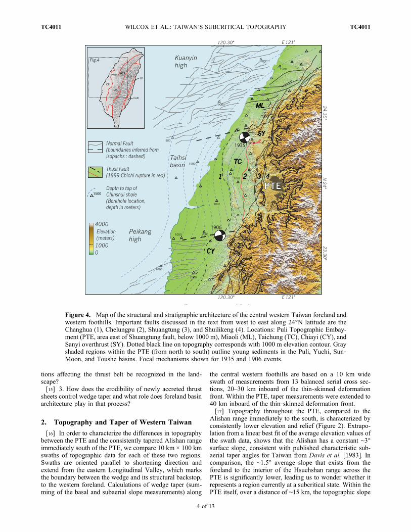
Figure 4. Map of the structural and stratigraphic architecture of the central western Taiwan foreland andwestern foothills. Important faults discussed in the text from west to east along 24°N latitude are theChanghua (1), Chelungpu (2), Shuangtung (3), and Shuilikeng (4). Locations: Puli Topographic Embay-ment (PTE, area east of Shuangtung fault, below 1000 m), Miaoli (ML), Taichung (TC), Chiayi (CY), andSanyi overthrust (SY). Dotted black line on topography corresponds with 1000 m elevation contour. Grayshaded regions within the PTE (from north to south) outline young sediments in the Puli, Yuchi, Sun‐Moon, and Toushe basins. Focal mechanisms shown for 1935 and 1906 events.
WILCOX ET AL.: TAIWAN’S SUBCRITICAL TOPOGRAPHY TC4011TC4011
4 of 13
is inclined ∼1–2 degrees to the east, which in the conventionof Taiwan’s wedge would be considered a negative taper(Figure 2). As a natural result of this lower surface slopewithin the PTE, the slope from the eastern margin of thePTE to the drainage divide at the crest of the orogen isanomalously steep, ∼9.5°.[18] Wedge taper calculated along the western foothills of
Taiwan varies depending on whether one uses the deeperMain Taiwan Detachment (MTD) or the more shallow thin‐skinned base of thrusting along the western foothills as thebasal surface of the critical wedge. Given the existing con-straints on the deeper MTD and apparently consistent dipand depth along strike of the distribution of seismicity[Carena et al., 2010], we use the better constrained shal-lower base of thin‐skinned thrusting measured from bal-anced cross sections throughout the foreland and westernfoothills. Calculated tapers for the Miaoli and Chiayi regionsare similar, with average values of ∼10–11 degrees forMiaoli and ∼13 degrees for Chiayi. In contrast, the PTEexhibits average values of ∼5 degrees, less than half thetaper of adjacent regions (Figure 3c). The changes in taperalong the western thrust belt, from the Hsuehshan range,across the PTE and into the Alishan range are spatiallyconsistent with other structural, stratigraphic and physio-graphic boundaries identified in this study. The difference intaper at this distance inboard from the thrust front (20–30 km) is primarily related to the relatively flat dip of thedecollement below the PTE, as first presented by Yue et al.[2005]. The dip of the decollement below Miaoli andChiayi are approximately −7 and −10 degrees, respectively,compared to approximately −1 below the PTE. Within thePTE, where the greater extent of cross sections allow us tocalculate taper further inboard than to the north or south, wesee a surprising result where due to the easterly averageaspect of surface slope and the continued low dip of the basalsurface of the shallow wedge, the taper we calculate isactually negative (∼−2 to −3 degrees), from 30 to 40 kminboard of the thrust front. This is an unexpected and unusualobservation within a critically tapered wedge, allowing us toclassify this region as subcritical, especially considering thatthe shallow wedge deforms above recorded overpressuredhorizons, in purely hydrostatically pressured rocks [Yue,2007].[19] Variation of the depth and geometry of the Main
Taiwan Detachment was also considered as an explanationfor the change in taper, but the relatively few availableconstraints on this deeper decollement level suggest that itexhibits a fairly consistent depth and dip along strike belowthe western foothills, varying on the order of 1 km or lessover distances of ∼50 km or more [Mouthereau and Petit,2003; Carena et al., 2010]. The use of relocated seismic-ity to accurately define the Main Taiwan Detachment hasbeen questioned by several authors [Simoes et al., 2007;Mouthereau et al., 2009] and so we calculated our de-terminations of wedge taper from balanced cross sections ofthe overriding thin‐skinned wedge.
3. Foreland and Western Thrust BeltArchitecture: Stratigraphy and Structure
[20] We consider the structural architecture and thick-nesses of synorogenic sediments throughout the central
western foreland and western foothills based on boreholemeasurements, seismic reflection data, published geologicmaps and 23 balanced cross sections located throughout theforeland and western foothills, made available to us by theChinese Petroleum Corporation (CPC). Seven of these crosssections have previously been published by Yang et al.[2007]. This paper reproduces only three representativecross sections for the north, central and south regions of ourstudy area, in accordance with permission given by theCPC. Additionally, we support our work with findings frompreviously published works.[21] The Chinese Continental Margin (CCM) supports the
western foreland of Taiwan, and has been well described interms of its depositional history and flexural response toorogenic loading [Lin and Watts, 2002; Mouthereau andPetit, 2003]. Synorogenic strata deposited in the westernforeland over the last six million years record the initialmigration of the foreland flexural bulge (evidenced by theflexural unconformity at the base of the Kueichulin For-mation: ∼6 ma) and subsequent approach and rapid erosionof the orogen (Chinshui Formation: ∼4 ma; Cholan For-mation: 3.1–1.1 ma; Toukoshan Formation: 1.1–0 ma) asthe thrust belt advances into the foreland basin [Chen et al.,2001; Lin et al., 2003].[22] The central western thrust belt of Taiwan deforms a
sequence of Tertiary to Quaternary strata, divided for ourpurposes into preorogenic and synorogenic groups, separatedby the flexural unconformity at the base of the KueichulinFormation. Miocene and older preorogenic stratigraphicunits have undergone an earlier history of extension alongthe CCM [Mouthereau and Lacombe, 2006; Mouthereauet al., 2002; Lin et al., 2003]. The architecture of the pas-sive margin includes a pair of salient basement highs, buriedby variable thicknesses of preorogenic and synorogenicsediments [Byrne and Liu, 2002; Mouthereau et al., 2002].Miocene extension of the passive margin is marked bynortheast‐southwest trending normal fault arrays that boundthese two structural highs, now located offshore in the fore-land basin west of the Taiwan thrust belt [Mouthereau et al.,2002; Lacombe et al., 2003]. The Kuanyin and Peikangbasement highs are located northwest of the Taichung basinand west of Chiayi, respectively, buttressing the precollisionalTaihsi basin (Figure 4).
3.1. Miocene‐Pliocene Synorogenic Stratigraphy
[23] While the eastern portion of the early Taihsi exten-sional basin has been removed by erosion after its accretioninto the advancing thrust belt, the western part of the basin iswell defined in the modern foreland of western Taiwan.Previous work mapping isopachs and structural stylesthroughout the foreland delineate three distinct regions ofwithin our study area that lie adjacent to, and correspondwith, distinct topographic regions in the thrust belt, includingthe northern Hsuehshan, PTE and northern Alishan regions[Mouthereau et al., 2002]. Measured along‐strike differ-ences in the thickness of the Kueichulin formation are rel-atively small and on the order of hundreds of meters, and weinterpret thickness changes within these sediments as growthstrata related to slip on foreland normal faults (Figure 3).Kueichulin growth strata bounded by extensional faults in theforeland are overlain by a thin sequence of early Plioceneshale of the Chinshui Formation, which does not vary in
WILCOX ET AL.: TAIWAN’S SUBCRITICAL TOPOGRAPHY TC4011TC4011
5 of 13

thickness appreciably from north to south along the CCM.These strata indicate that extension of the continental shelfhad ceased by the early Pliocene, marking the transition in theforeland from an extensional to a compressive setting. Thephysical characteristics of the Chinshui Shale are consistentwith it being deposited in the distal foreland of the ap-proaching orogenic wedge. This shale is a primary decolle-ment level for thin‐skinned deformation in central Taiwan.
3.2. Late Pliocene–Quaternary Synorogenic Sediments
[24] Spanning from late Pliocene to Quaternary time,flexural loading in the foreland of the encroaching thrustbelt is recorded by the upward coarsening sequence of theCholan and Toukoshan formations. The 3.1–1.1 Ma Cholanformation is largely uniform in thickness from north to southalong the strike of the Taiwanese foreland, except where itthickens over the shelf break south of the Peikang High(from ∼2000 m to almost 3500 m over a distance of 100 km(Figure 3). The geometry of the Cholan age foreland basin iswell constrained from boreholes and seismic reflectionprofiles and is interpreted as the distal to intermediate por-tion of the foreland basin during the earlier stages of thedevelopment of the Taiwanese thrust belt [Yu and Chou,2001; Lin and Watts, 2002].[25] The Toukoshan formation is the youngest major
synorogenic deposit in central western Taiwan, apart fromQuaternary terraces and fluviolacustrine sediments preservedin wedge‐top basins. The Toukoshan formation includes twocoarsening upward members (the Hsiangshan sandstone andHuoyenshan conglomerate) that are interpreted as signalingthe approach of the leading edge of the thrust belt during thelast ∼1.1 Ma [Chen et al., 2001]. Unlike older stratigraphicunits, the thickness of Toukoshan in seismic reflectionprofiles and boreholes varies by up to a factor of 3 fromnorth to south along the foreland in central Taiwan[Mouthereau et al., 2002]. Previous work [Mouthereau etal., 1999] and cross sections made available to us by theCPC indicate that the thickness of the Toukoshan formationincreases abruptly within the 60 km wide Taichung basinlocated immediately west of the PTE (Figures 3 and 4). Thethickness of Toukoshan formation measured on a NNE‐SSW trending strike‐parallel profile increases from a mini-mum of ∼1000 m near the Kuanyin basement high to over3500 m within 50 km in the central Taiwanese foreland.These strata thin again across the Peikang basement highbefore increasing in thickness over the shelf edge of theCCM to the south. Notably, these marked variations inthickness occur at the same locations as underlying arrays ofolder Miocene normal faults bounding basement highs(Figures 3 and 4). The abrupt change in thickness in thesynorogenic Toukoshan formation here suggests that olderinherited structures may affect accommodation space in theforeland, driven by compressively reactivated deformationand loading of the thrust belt.
3.3. Extensional Structures in the Foreland
[26] Previous works [Mouthereau et al., 2002; Lin et al.,2003; Mouthereau and Lacombe, 2006] identify inversionof Miocene extensional faults as younger oblique thrust andstrike slip faults in both the modern foreland basin and withinthe thrust belt itself. While not obvious in all availableseismic reflection profiles at scales of individual reflectors,
measurement of thickness changes in both extensional andcompressional growth strata at longer intervals support arecent history (1.1 Ma to present) of minor shortening tens ofkilometers into the foreland, west of the leading edge of thethin‐skinned thrust belt.[27] Evidence for normal sense displacement on these faults
is recorded by variable thicknesses within the Kueichulin andolder preorogenic formations that have subsequently beenincorporated and deformed in thrusts and folds within thewestern part of the Hsuehshan range. The origin of thesefaults as extensional structures is well defined by stratigraphiccutoff angles and thickness changes in adjacent fault boundedblocks between the Shuangtung and Shuilikeng thrusts. In thispart of the thrust belt, block bounding normal faults that cutacross thrust sheets trend similarly to faults imaged in off-shore seismic reflection profiles (Figure 4). We interpret theseas the continuation of fault arrays evident in the foreland, dueto their modern position and kinematic compatibility with thedirection of thrust shortening. Some of the fault‐boundedblocks retain a continuous Miocene stratigraphic record,while others contain disconformities, interpreted as a recordof early migration of the flexural forebulge as the thrust beltapproached from the east [Yu and Chou, 2001]. These faultsare typically oriented at a high angle to the strike of thrustsheets and act as tear faults during shortening [Lin, 2005].Strike slip focal mechanisms determined for two historic largeearthquakes, attributed to slip on the Meishan fault in 1906and the Tuntzuchiao fault in 1935, are oriented parallel toother Miocene age normal faults mapped by the CPC [Lin,2005; Shyu et al., 2005]. This suggests that those faults inparticular may act as the main structural boundaries betweenthe Miaoli, Taichung and Chiayi regions.[28] Previous work has suggested that differences in
structural style along the foreland and western foothills ofTaiwan can be attributed to variations in the strength ofbasement rocks that support the foreland basin [Mouthereauand Petit, 2003]. Miocene age normal faults in the Miaoliand Chiayi regions also affect subsequent thin‐skinnedcompressive strain north and south of the PTE [Suppe, 1986;Mouthereau et al., 2002]. In particular, the northern end ofthe Chelungpu fault and Sanyi overthrust presents a wellstudied example of the interactions between advancing thin‐skinned deformation that overlies preexisting structures inthe foreland basement [Yue et al., 2005; Yue, 2007].[29] In contrast to normal faults adjacent to the Miaoli and
Chiayi regions, normal faults in the Taichung region arescarce and generally not favorably oriented for reactivationas oblique or strike‐slip faults. The relatively few faults thatare present instead act to localize structural ramps wheredecollement horizons are offset by these faults [Mouthereauet al., 1999; Lee and Chan, 2007].
4. Thrust Belt Development and ForelandProperties
[30] Discrete arrays of Miocene age normal faults parti-tion the foreland of central Taiwan into three regions thathave experienced radically different subsidence historiessince 1.1 Ma, as evidenced by the thickness of Quaternarysediments in each region (Figures 3, 4, and 5). From northto south these regions are (1) the Kuanyin High, which
WILCOX ET AL.: TAIWAN’S SUBCRITICAL TOPOGRAPHY TC4011TC4011
6 of 13
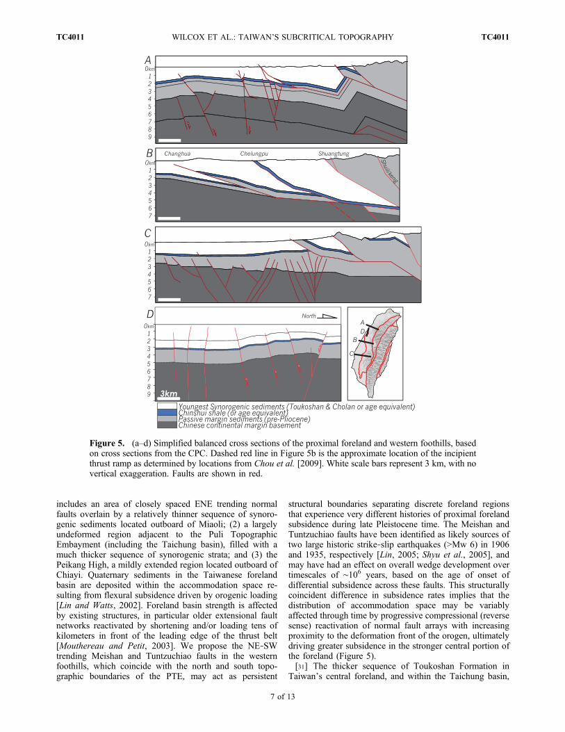
includes an area of closely spaced ENE trending normalfaults overlain by a relatively thinner sequence of synoro-genic sediments located outboard of Miaoli; (2) a largelyundeformed region adjacent to the Puli TopographicEmbayment (including the Taichung basin), filled with amuch thicker sequence of synorogenic strata; and (3) thePeikang High, a mildly extended region located outboard ofChiayi. Quaternary sediments in the Taiwanese forelandbasin are deposited within the accommodation space re-sulting from flexural subsidence driven by orogenic loading[Lin and Watts, 2002]. Foreland basin strength is affectedby existing structures, in particular older extensional faultnetworks reactivated by shortening and/or loading tens ofkilometers in front of the leading edge of the thrust belt[Mouthereau and Petit, 2003]. We propose the NE‐SWtrending Meishan and Tuntzuchiao faults in the westernfoothills, which coincide with the north and south topo-graphic boundaries of the PTE, may act as persistent
structural boundaries separating discrete foreland regionsthat experience very different histories of proximal forelandsubsidence during late Pleistocene time. The Meishan andTuntzuchiao faults have been identified as likely sources oftwo large historic strike‐slip earthquakes (>Mw 6) in 1906and 1935, respectively [Lin, 2005; Shyu et al., 2005], andmay have had an effect on overall wedge development overtimescales of ∼106 years, based on the age of onset ofdifferential subsidence across these faults. This structurallycoincident difference in subsidence rates implies that thedistribution of accommodation space may be variablyaffected through time by progressive compressional (reversesense) reactivation of normal fault arrays with increasingproximity to the deformation front of the orogen, ultimatelydriving greater subsidence in the stronger central portion ofthe foreland (Figure 5).[31] The thicker sequence of Toukoshan Formation in
Taiwan’s central foreland, and within the Taichung basin,
Figure 5. (a–d) Simplified balanced cross sections of the proximal foreland and western foothills, basedon cross sections from the CPC. Dashed red line in Figure 5b is the approximate location of the incipientthrust ramp as determined by locations from Chou et al. [2009]. White scale bars represent 3 km, with novertical exaggeration. Faults are shown in red.
WILCOX ET AL.: TAIWAN’S SUBCRITICAL TOPOGRAPHY TC4011TC4011
7 of 13
lies immediately west of the PTE. The margins of the area ofincreased fill, where Toukoshan thickens from ∼1500 m toover 3300 m in as little as 20 km, are coincident with thenorthern and southern boundaries of the PTE, as defined bythe 2000 m elevation contour of the orogen (Figure 3)[Wilcox et al., 2007]. This close spatial correlation ofstructural boundaries with changes in topography, taper andlate Pleistocene stratigraphic thickness suggests that therheology and/or erodibility of synorogenic strata accretedinto the adjacent thrust belt may exert a primary controlaffecting wedge development [Upton et al., 2009b].[32] While the effects of uneven erosion on wedge
development in Taiwan has been explored by Upton et al.[2009b], our work is aimed at understanding how andwhy a subcritical state (as defined above) was initiated andis currently preserved in the PTE. We argue that the thicksection of synorogenic sediments outboard of the PTE thatcapped thrust sheets accreted into the belt were more deeplyincised to the level of older preorogenic strata below. Thisthicker central sequence sets an initial rheological templatethat controls thin‐skinned wedge development over time-scales of at least 104–105 years. A corollary follows that thesequence of thicker young synorogenic strata is weaker andmore susceptible to erosion than older rocks, which isexplored in section 5 on numerical modeling.
5. Modeling Critical Wedges With VariableMaterial Properties
[33] The recognition of along‐strike variations in thematerial properties of the foreland and associated impacts onlong‐term development of wedge topography, taper andstrain organization highlight the need to better understandhow critical wedges respond along their length to differ-ences in material properties (rheology) and rates of surficialprocesses (erosion). This section explores mechanical con-ditions that collectively contribute to a subcritical regionwithin a thin‐skinned orogenic wedge, which we compare tothe PTE in Taiwan. Although foreland basement strength isaffected by the presence of Miocene normal fault arrays[Mouthereau and Petit, 2003] our exploration of wedgebehavior focuses solely on the internal kinematics of a thin‐skinned thrust belt, rather than any processes occurringbelow the thin‐skinned decollement.
5.1. Modeling Methods
[34] For this study, we build on previously publishedmodels of a generic fold and thrust belt of similar dimen-sions to Taiwan [Upton et al., 2009b]. Our geometryconsists of an elastic slab, representing the basement of thewestern foreland, beneath an elastoplastic Mohr‐Coulombwedge, representing passive margin sediments deformed inwestern Taiwan (Figure 6a). These are separated by aninterface along which frictional slip can occur but acrosswhich no material exchange occurs. The three‐dimensionalnumerical region extends 220 km parallel to convergence(= x) by 250 km perpendicular to convergence (= y) by18 km vertically (= z). The eastern edge of the modelconsists of an elastic block simulating a rigid indentor, suchas a colliding volcanic arc, that does not deform internallyto a significant extent.
[35] Models were developed using the numerical codeFLAC3D version 3.1 (Itasca, 2006), which we have modifiedto accommodate local erosion. FLAC3D utilizes a modifiedLagrangian finite difference technique and its use for solv-ing geological problems is well established. The methodsused have been described previously [see Upton et al., 2003;Johnson et al., 2004; Upton et al., 2009a, 2009b].
5.2. Model Runs
[36] We present four models: model 0, a reference model,with no variation along strike, identical to model 0 of Uptonet al. [2009b] (Figure 6b); model 1, a model with a region oflower density, weaker material in the outboard wedge,similar to model 2 of Upton et al. [2009b]; model 2, a modelwith a region of enhanced erosion within the front of thewedge (3 mm/yr compared to a background of 1 mm/yr);and model 3, a model which combines the conditions of 1and 2 above.[37] All models use the same velocity boundary condi-
tion: the elastic indentor acting as the backstop of thewedge moves over the decollement interface at 20 mm/yr(Figure 6a). Throughout the discussion of the models, thespatial frame of reference is analogous to that of the westernTaiwanese thrust belt; the wedge verges west and “inboard”refers to positions toward the backstop to the east, while“outboard” refers to positions toward the foreland to thewest. The models were run to approximately 9% strain,which is the limit of the model grid before numerical in-stabilities begin [Upton et al., 2009b]. Erosion is imposedon the top surface of the model as a boundary condition,whereby material is removed from the model by lowering ofthe top surface. An erosion rate of 1 mm/yr is imposed onthe western part of the model orogen while 1.3 mm/yr isimposed on the eastern part, simulating a mild orographiceffect from the central uplift zone in the model. The juxta-position of focused rapid erosion against a low backgrounderosion rate is meant to represent the condition of a thickersection of easily erodible cover material next to harder olderrocks, which have already been exposed. Given the lowshortening rates (relative to Taiwan), limited strain andimposed boundary conditions of erosion, the values wedetermine from our models are best considered qualitativelyin terms of effects on kinematic behavior observed withinthe model wedge. We note that increasing shortening rate toa value similar to what is observed in Taiwan would merelydecrease the model run times, since the models are limitedby the total strain they can accommodate.
5.3. Model Results
5.3.1. Model 1[38] As shown previously, material variations within the
wedge affect the form of the wedge [Upton et al., 2009b].Rock uplift and strain are focused into weaker material,which creates a narrow ridge at the inboard edge of theweaker material, and subsequently decreasing the magni-tudes of rock uplift and strain within the adjacent region ofstronger material to the east (Figure 6c). When compared tothe reference model, there is a decrease in elevation inboardof the region of weaker material, creating a topographicembayment that is deeper than the embayment resultingfrom erosion alone (model 2). The along‐strike extent of the
WILCOX ET AL.: TAIWAN’S SUBCRITICAL TOPOGRAPHY TC4011TC4011
8 of 13

resulting embayment is roughly equivalent to the width ofthe region of weaker material ahead of it.5.3.2. Model 2[39] Variation of the erosion rate within the front of the
wedge has a broad effect on wedge kinematics, well outsidethe extent of focused erosion. In fact, the impact of a
focused increase in erosion rate on wedge kinematics canextend across the entire width of the wedge (Figure 6d). Wenote measurable differences from the reference model inelevation and magnitude of both rock uplift and strain thatextend from the foreland across the wedge to the backstop.This is a result of removing mass from the orogen that
Figure 6. (a) FLAC3D model setup, (b) reference wedge, and (c, d, e) model results. Differences areachieved by subtracting a given model result from the reference model.
WILCOX ET AL.: TAIWAN’S SUBCRITICAL TOPOGRAPHY TC4011TC4011
9 of 13

would otherwise (e.g., in the reference model) contribute tothe internal stability of the critical wedge. By removing thismass the internal balance of the critical wedge is disturbedand rock uplift is focused into the region of higher erosionrate. As a result, rock uplift and strain are reduced bothinboard and outboard of the rapidly eroding region, in effectbalancing the overall strain budget of the wedge. As with theprevious model, a decrease in rock uplift and strain inboardof the region of higher erosion creates a topographicembayment roughly equivalent in scale to the along‐strikeextent of the increase in erosion rate.5.3.3. Model 3[40] This model combines variation in material properties
and focused erosion from models 1 and 2. This combinationmost closely represents the conditions of western Taiwan,where thick synorogenic sediments are rapidly incised abovefrontal thrust ramps. Because the effects on topography,rock uplift and strain are largely similar for both the indi-vidual preceding models, we see the combination of thoseeffects is mostly constructive in this model (Figure 6e). Therelief of the resulting topographic embayment is greater thanin model 1 or 2, and is predicted to be at least 1000 m. Thealong‐strike scale of the embayment is again roughly equalto the size of the regions of weak material and high erosionrate. Clear differences relative to the reference model intopography, rock uplift and strain are observed across theentire width of the wedge, similar to model 2.
6. Discussion
[41] Subcritical portions of rapidly eroding thrust wedgeshave been identified in a number of compressive orogensaround the world. Most notably these include glaciatedregions undergoing rapid and spatially limited erosion, suchas within the St Elias orogen in Alaska [Berger et al., 2008;Meigs et al., 2008]. Additionally, sharp orographic pre-cipitation gradients driven by the Indian Ocean monsoonhave been cited as driving accelerated erosion inboard ofthe leading edge of the Himalayas [Thiede et al., 2004;Wobus et al., 2003]. In contrast, extraordinarily high ratesof fluvial erosion have been associated with the develop-ment of a crustal aneurysm in the Eastern Syntaxis of theHimalaya [Zeitler et al., 2001] on a scale comparable to thedimensions of the PTE. High rates of exhumation occursome 100 km from the active thrust front in the Himalaya[Thiede et al., 2004; Wobus et al., 2003], and at about 50–70 km in the St Elias Orogen [Berger et al., 2008; Meigset al., 2008]. We note that the location of these increasesin rock uplift rate and erosion rate are set by the atmosphericconditions of the orogens in which they occur; that is, theyare controlled by climate, as opposed to stratigraphicarchitecture which acts as the primary control on variationsin erosion rate in western Taiwan. The results of our modelssuggest that focused erosion may exert a stronger andbroader influence on the organization of strain across theentire width of an active orogenic wedge than a change inmaterial properties at the leading edge of the orogen. Evenwithout considering changes in decollement geometry orvariations in the strength of the foreland basement, we seethat the combination of rapid erosion and a thick section ofrelatively weak material near the front of the wedge predicts
a significant topographic embayment inboard of the changein boundary conditions, on the order of the scale of the PTE.[42] The subcritical portion of the Taiwanese thrust belt
formed at spatial scales of tens of kilometers, and this scaleis likely controlled by the spacing of individual thrustswithin the orogen [Upton et al., 2009b] and by the spacingof preexisting normal fault arrays in the foreland. Thisscaling is analogous to the observations of relative scale inour models, where the spatial scale of variations in forelandconditions controls the along‐strike extent of variations intopography and strain within the wedge.[43] Precipitation in Taiwan is characterized by very large
rainfall events associated with large typhoons, which arecapable of delivering more than a meter of rainfall over aperiod of 24 h [Galewsky et al., 2006]. While precipitationincreases with elevation in western Taiwan, rainfall alongthe Foothills Belt and Hsuehshan range is essentially similaralong the length of the thrust belt and is in fact contempo-rarily lower in the PTE itself [Galewsky et al., 2006].Contemporary erosion rates within the PTE are actuallyquite low, whereas the incision of stream channel networks(and related removal of mass) is focused outboard of thePTE within the active foothills of the orogen [Dadson et al.,2003]. These sediments are transported to the forelandwhere variably thick (∼2–5 km) sections of synorogenicstrata have yet to be accreted at the front of the orogen.[44] We posit that rapid incision into exposed sections of
Toukoshan and Cholan formations in active thrust sheets islikely related to their unconsolidated nature and negligiblediagenetic history during burial within the foreland basin[Chen et al., 2001]. The primary control on incision of rivernetworks and focusing of erosion into the proto‐PTE islikely related to the variable thickness of synorogenic stratathat cap active thrust sheets in the foreland. Removing therelatively thinner sequences of Pleistocene sediments thatcapped thrust sheets north and south of the proto‐PTE resultsin relatively earlier exposure of the harder and less erodibleMiocene and Oligocene rocks in the northern Hsuehshanand northern Alishan ranges. River networks would thusnaturally focus and more deeply incise the thicker sectionof synorogenic sediment capping thrust sheets within theproto‐PTE (Figure 7). As observed in our models, the for-mation of a topographic embayment is predicted inboard ofa region undergoing focused rapid erosion, due to the dis-turbance of the internal mass balance of the critical wedgeand subsequent reorganization of strain.[45] The coincidence of mapped locations of abrupt
changes in thickness of late Pleistocene synorogenic fill,lower average topography within the PTE and the locationsof at least three recent (1906–1999) large earthquakes(>Mw 6) that occurred along topographic and structuralboundaries of the embayment can be attributed to the variablestructural architecture and contemporary kinematics of thecentral Taiwan foreland. This suggests that the history ofsubsidence in the foreland controls both denudation andreorganization of strain in the thrust belt, such that a sub-critical state is initiated and maintained at timescales of up to106 years. We propose that variable subsidence of the fore-land basin, controlled by the orientations and spatial dis-tributions of reactivated older structures, has a profoundinfluence on the distribution of strain within the eroding
WILCOX ET AL.: TAIWAN’S SUBCRITICAL TOPOGRAPHY TC4011TC4011
10 of 13

portion of the thrust belt. Potentially this influence could beobserved across the entire width of the orogenic wedge.
7. Summary
[46] The contemporary presence of a region of anoma-lously low topography within the Taiwanese thrust beltprovides insight into the processes that initiate and maintaina subcritical condition in a thin‐skinned compressive wedge.The causal links between the foreland structural architecture,synorogenic stratigraphic architecture and presence of thePuli Topographic Embayment provides a valuable casestudy of the effects of changing boundary conditions con-trolling the evolution of critical thin‐skinned orogens.Moreover, the preexisting structural architecture within theforeland appears to strongly influence subsidence behavior,resulting in abrupt and localized differences in the thicknessof foreland basin fill. Deeper incision of river networks intothe thicker sequence of unconsolidated fill in the centralwestern foreland may then focus erosion within the proto‐PTE, initiating the onset of a subcritical state. The onset offocused erosion related to the PTE is unknown. However,estimates based on the thickness of Toukoshan strata, res-toration of slip along the Chelungpu and Shuangtung thrustsand an assumption of ∼45 mm/yr of shortening across theentire foothills belt suggest the PTE may have been initiatedbetween ∼700 and 500 Ka. This suggests that a subcriticalstate may exist within the western Taiwanese thrust belt fora significant fraction of its total development.
[47] Acknowledgments. We would like to acknowledge the ChinesePetroleum Company, Wen‐Rong Chi, and Kenn‐Ming Yang for access totheir data and many helpful discussions. John Suppe and Tony Watts werealso immensely helpful in offering comments and enlightening discussion.This paper also benefited from the constructive reviews of FredericMouthereau and Bruce Shyu. We would additionally like to thank Ling‐Ho Chung, Po‐Nong Lee, and Shao‐Yi Huang for logistical support inthe field. This research was funded by NSF grant EAR‐0510971.
ReferencesBerger, A. L., et al. (2008), Quaternary tectonic response to intensified gla-cial erosion in an orogenic wedge, Nat. Geosci. , 1 , 793–799,doi:10.1038/ngeo334.
Byrne, T. B., and C.‐S. Liu (2002), Introduction to the geology and geo-physics of Taiwan, in Geology and Geophysics of an Arc‐ContinentCollision, Taiwan, edited by T. B. Byrne and C.‐S. Liu, Spec. Pap.Geol. Soc. Am., 358, v–viii.
Carena, S., J. Suppe, and H. Kao (2002), Active detachment of Taiwanilluminated by small earthquakes and its control of first‐order topogra-phy, Geology, 30, 935–938, doi:10.1130/0091-7613(2002)030<0935:ADOTIB>2.0.CO;2.
Carena, S., J. Suppe, and Y.‐M. Wu (2010), Lithospheric structure ofTaiwan from seismicity and crustal tomography, Geol. Soc. Am. Abstr.Programs, 42(5), 78.
Chang, C. P., T. Y. Chang, J. Angelier, H. Kao, J. C. Lee, and S. B. Yu(2003), Strain and stress field in Taiwan oblique convergent system:Constraints from GPS observation and tectonic data, Earth Planet. Sci.Lett., 214, 115–127, doi:10.1016/S0012-821X(03)00360-1.
Chen, W.‐S., K. D. Ridgway, C. S. Horng, Y. G. Chen, K. S. Shea, andM. G. Yeh (2001), Stratigraphic architecture, magnetostratigraphy, andincised‐valley systems of the Pliocene‐Pleistocene collisional marineforeland basin of Taiwan, Geol. Soc. Am. Bull., 113, 1249–1271,doi:10.1130/0016-7606(2001)113<1249:SAMAIV>2.0.CO;2.
Chou, C., J. Suppe, S. Carena, and S. Huang (2009), Advances in 3Dimaging of the geometry of the Chi‐Chi earthquake thrust system inwestern Taiwan, Eos Trans AGU, 90(52), Fall Meet. Suppl., AbstractT33B‐1896.
Dadson, S. J., et al. (2003), Links between erosion, runoff variability andseismicity in the Taiwan orogen, Nature, 426(6967), 648–651,doi:10.1038/nature02150.
Dahlen, F. A., and J. Suppe (1988), Mechanics, growth, and erosion ofmountain belts, in Processes in Continental Lithospheric Deformation,edited by S. P. Clark, B. C. Burchfiel, and J. Suppe, Spec. Pap. Geol.Soc. Am., 218, 161–178.
Davis, D., J. Suppe, and F. A. Dahlen (1983), Mechanics of fold‐and‐thrustbelts and accretionary wedges, J. Geophys. Res., 88, 1153–1172,doi:10.1029/JB088iB02p01153.
Deffontaines, B., J.‐C. Lee, J. Angelier, J. Carvalho, and J.‐P. Rudant(1994), New geomorphic data on the active Taiwan orogen: A multi-source approach, J. Geophys. Res., 99, 20,243–20,266, doi:10.1029/94JB00733.
England, P. C., and P. Molnar (1990), Surface uplift, uplift of rocks, andexhumation of rocks, Geology, 18, 1173–1177, doi:10.1130/0091-7613(1990)018<1173:SUUORA>2.3.CO;2.
Fuller, C. W., S. D. Willett, D. Fisher, and C. Y. Lu (2006), A thermome-chanical wedge model of Taiwan constrained by fission‐track thermo-chronometry, Tectonophysics , 425 , 1–24, doi:10.1016/j.tecto.2006.05.018.
Galewsky, J., C. P. Stark, S. Dadson, C.‐C. Wu, A. H. Sobel, and M.‐J.Horng (2006), Tropical cyclone triggering of sediment discharge inTaiwan, J. Geophys. Res., 111, F03014, doi:10.1029/2005JF000428.
Hilley, G. E., and M. R. Strecker (2004), Steady state erosion of criticalCoulomb wedges with applications to Taiwan and the Himalaya, J. Geo-phys. Res., 109, B01411, doi:10.1029/2002JB002284.
Johnson, S. E., R. H. Vernon, and P. Upton (2004), Foliation developmentand progressive strain‐rate partitioning in the crystallizing carapace of
Figure 7. Schematic block diagrams of land surface evolution, controlled by distribution of thicknessesof easily eroded synorogenic sediments. Early stage: foreland template is set by varying subsidence alongstrike, with thicker sequence of easily erodible sediment in central region. Intermediate stage: material isaccreted into wedge initiating rock uplift. As rocks are brought above local base level, different rheologiesrespond to river incision at different rates and drainages are reorganized. Proto‐Puli: all synorogenic sed-iment is flushed from uplifted region into the foreland basin. Beginning at the intermediate stage, focusederosion should start to affect topographic growth and strain organization (see Figure 6 and section 6).Dashed line represents local base level, and textured blue lines represent rivers.
WILCOX ET AL.: TAIWAN’S SUBCRITICAL TOPOGRAPHY TC4011TC4011
11 of 13
a tonalite pluton: Microstructural evidence and numerical modeling,J. Struct. Geol., 26, 1845–1865.
Konstantinovskaia, E., and J. Malavieille (2005), Erosion and exhumationin accretionary orogens: Experimental and geological approaches, Geo-chem. Geophys. Geosyst., 6, Q02006, doi:10.1029/2004GC000794.
Koons, P. O., R. J. Norris, D. Craw, and A. F. Cooper (2003), Influence ofexhumation on the structural evolution of transpressional plate bound-aries: An example from the Southern Alps, New Zealand, Geology, 31,3–6, doi:10.1130/0091-7613(2003)031<0003:IOEOTS>2.0.CO;2.
Lacombe, O., F. Mouthereau, J. Angelier, H.‐T. Chu, and J.‐C. Lee (2003),Frontal belt curvature and oblique ramp development at an obliquely col-lided irregular margin: Geometry and kinematics of the NW Taiwan fold‐thrust belt, Tectonics, 22(3), 1025, doi:10.1029/2002TC001436.
Lee, J.‐C., and Y.‐C. Chan (2007), Structure of the 1999 Chi‐Chi earth-quake rupture and interaction of thrust faults in the active fold belt ofwestern Taiwan, J. Asian Earth Sci., 31, 226–239, doi:10.1016/j.jseaes.2006.07.024.
Lin, A. T., and A. B. Watts (2002), Origin of the West Taiwan basin byorogenic loading and flexure of a rifted continental margin, J. Geophys.Res., 107(B9), 2185, doi:10.1029/2001JB000669.
Lin, A. T., A. B. Watts, and S. P. Hesselbo (2003), Cenozoic stratigraphyand subsidence history of the South China Sea margin in the Taiwanregion, Basin Res., 15, 453–478, doi:10.1046/j.1365-2117.2003.00215.x.
Lin, C. W., S. H. Liu, S. Y. Lee, and C. C. Liu (2006), Impacts of theChi‐Chi earthquake on subsequent rainfall‐induced landslides in centralTaiwan, Eng. Geol. Amsterdam, 86, 87–101, doi:10.1016/j.enggeo.2006.02.010.
Lin, Y. N. (2005), Surface deformation and seismogenic structure model ofthe 1935 Hsinchu‐Taichung earthquake (Mgr = 7.1), in Miaoli, north-western Taiwan, M.Sc. thesis, 92 pp., Natl. Taiwan Univ., Taipei.
Liu, T. K., S. Hsieh, Y. G. Chen, and W. S. Chen (2001), Thermo‐kinematic evolution of the Taiwan oblique‐collision mountain beltas revealed by zircon fission track dating, Earth Planet. Sci. Lett.,186, 45–56, doi:10.1016/S0012-821X(01)00232-1.
Lu, C.‐Y., and J. Malavieille (1994), Oblique convergence, indentation androtation tectonics in the Taiwan Mountain Belt: Insights from experimen-tal modeling, Earth Planet. Sci. Lett., 121, 477–494, doi:10.1016/0012-821X(94)90085-X.
Lu, C.‐Y., H.‐T. Chu, J.‐C. Lee, Y.‐C. Chan, K.‐J. Chang, and F.Mouthereau(2002), The 1999 Chi‐Chi Taiwan earthquake and basement impact thrustkinematics, West. Pac. Earth Sci., 2(2), 181–190.
Meigs, A., S. Johnston, J. Garver, and J. Spotila (2008), Crustal‐scalestructural architecture, shortening, and exhumation of an active, erodingorogenic wedge (Chugach, St Elias range, southern Alaska), Tectonics,27, TC4003, doi:10.1029/2007TC002168.
Mosar, J. (1999), Present‐day and future tectonic underplating in the westernSwiss Alps: Reconciliation of basement/wrench‐faulting and décollementfolding of the Jura andMolasse basin in the Alpine foreland, Earth Planet.Sci. Lett., 173, 143–155, doi:10.1016/S0012-821X(99)00238-1.
Mouthereau, F., and O. Lacombe (2006), Inversion of the Paleogene con-tinental margin and thick‐skinned deformation in the western foreland ofTaiwan, J. Struct. Geol., 28, 1977–1993, doi:10.1016/j.jsg.2006.08.007.
Mouthereau, F., and C. Petit (2003), Rheology and strength of the Eurasiancontinental lithosphere in the foreland of the Taiwan collision belt: Con-straints from seismicity, flexure, and structural styles, J. Geophys. Res.,108(B11), 2512, doi:10.1029/2002JB002098.
Mouthereau, F., O. Lacombe, B. Deffontaines, J. Angelier, H. T. Chu, andC. T. Lee (1999), Quaternary transfer faulting and belt front deformationat Pakuashan (western Taiwan), Tectonics, 18(2), 215–230.
Mouthereau, F., B. Deffontaines, O. Lacombe, and J. Angleier (2002),Variations along the strike of the Taiwan thrust belt: Basement controlof structural style, wedge geometry, and kinematics, in Geology andGeophysics of an Arc‐Continent Collision, Taiwan, edited by T. B.Byrne and C.‐S. Liu, Spec. Pap. Geol. Soc. Am., 358, 35–58.
Mouthereau, F., C. Fillon, and K.‐F. Ma (2009), Distribution of strain ratesin the Taiwan orogenic wedge, Earth Planet. Sci. Lett., 284, 361–385,doi:10.1016/j.epsl.2009.05.005.
Mueller, K. J., Y. Chen, and G. Kier (2001), Erosion‐induced backsteppingand reactivation of the Chelungpu thrust: Implications for patterns ofmodern strain release in west‐central Taiwan, Eos Trans. AGU, 82(47),Fall Meet. Suppl., Abstract T32A‐0878.
Mueller, K., Y. Chen, and L. Powell (2002), Modern strain and structuralarchitecture of the central Taiwanese orogen: Evidence for active back-stepping in response to erosion?, Eos Trans. AGU, 83(47), Fall Meet.Suppl., Abstract T61B‐1279.
Mueller, K., T. Wilcox, and Y. Chen (2006), Subcritical thrust wedgedevelopment in west‐central Taiwan in response to rapid erosion of sy-norogenic sediments, Eos Trans. AGU, 87(52), Fall Meet. Suppl.,Abstract T11A‐0433.
Powell, L. K. (2003), Feedback between erosion and fault reactivation inthe Puli Basin: Hsüehshan Belt of central Taiwan, M.S. thesis, 61 pp.,Univ. of Colo. at Boulder, Boulder.
Powell, L., K. Mueller, and Y. Chen (2002), Geomorphic constraints onpatterns of shortening and erosion in the Puli Basin: Hinterland of thecentral Taiwan Thrust Belt, Eos Trans. AGU, 83(47), Fall Meet. Suppl.,Abstract T61B‐1270.
Roe, G. H., D. B. Stolar, and S. D. Willett (2006), Response of a steady‐state critical wedge orogen to changes in climate and tectonic forcing, inTectonics, Climate, and Landscape Evolution, Spec. Pap. Geol. Soc. Am.,398, 227–239.
Shyu, J. B. H., K. Sieh, Y.‐G. Chen, and C.‐S. Liu (2005), Neotectonicarchitecture of Taiwan and its implications for future large earthquakes,J. Geophys. Res., 110, B08402, doi:10.1029/2004JB003251.
Simoes, M., and J. P. Avouac (2006), Investigating the kinematics ofmountain building in Taiwan from the spatiotemporal evolution of theforeland basin and western foothills, J. Geophys. Res., 111, B10401,doi:10.1029/2005JB004209.
Simoes, M., J. P. Avouac, Y.‐G. Chen, A. K. Singhvi, C.‐Y. Wang,M. Jaiswal, Y.‐C. Chan, and S. Bernard (2007), Kinematic analysisof the Pakuashan fault tip fold, west central Taiwan: Shortening rateand age of folding inception, J. Geophys. Res., 112, B03S14,doi:10.1029/2005JB004198.
Suppe, J. (1980), Imbricated structure of western foothills belt, south‐centralTaiwan, Pet. Geol. Taiwan, 17, 1–16.
Suppe, J. (1986), Reactivated normal faults in the western Taiwan fold‐and‐thrust belt, Mem. Geol. Soc. China, 7, 187–200.
Thiede, R. C., B. Bookhagen, J. R. Arrowsmith, E. R. Sobel, and M. R.Strecker (2004), Climatic control on rapid exhumation along the southernHimalayan front, Earth Planet. Sci. Lett., 222, 791–806, doi:10.1016/j.epsl.2004.03.015.
Upton, P., P. O. Koons, and D. Eberhart‐Phillips (2003), Extension andpartitioning in an oblique subduction zone, New Zealand: Constraintsfrom three‐dimensional numerical modeling, Tectonics, 22(6), 1068,doi:10.1029/2002TC001431.
Upton, P., P. O. Koons, D. Craw, C. M. Henderson, and R. Enlow (2009a),Along‐strike differences in the Southern Alps of New Zealand: Conse-quences of inherited variation in rheology, Tectonics, 28, TC2007,doi:10.1029/2008TC002353.
Upton, P., K. Mueller, and Y.‐G. Chen (2009b), Three‐dimensionalnumerical models with varied material properties and erosion rates:Implications for the mechanics and kinematics of compressive wedges,J. Geophys. Res., 114, B04408, doi:10.1029/2008JB005708.
Wilcox, T., K. Meuller, and Y. Chen (2007), Systematic variations insynorogenic fill architecture and fault offsets along strike across thePuli Topographic Embayment: Quaternary strain gradients in the centralwestern foothills and Taiwanese foreland basin, Eos Trans. AGU, 88(52), Fall Meet. Suppl., Abstract T32C‐07.
Willett, S. D. (1999), Orogeny and orography: The effect of erosion on thestructure of mountain belts, J. Geophys. Res., 104(B12), 28,957–28,981,doi:10.1029/1999JB900248.
Wobus, C. W., K. V. Hodges, and K. X. Whipple (2003), Has focuseddenudation sustained active thrusting at the Himalayan topographicfront?, Geology, 31, 861–864, doi:10.1130/G19730.1.
Yang, K.‐M., S.‐T. Huang, J.‐C. Wu, H.‐H. Ting, W.‐W. Mei, M. Lee,H.‐H. Hsu, and C.‐J. Lee (2007), 3D geometry of the ChelungpuThrust System in central Taiwan: Its implications for active tectonics,Terr . A tmos . Ocean . Sc i . , 18 (2 ) , 143–181 , do i :10 .3319 /TAO.2007.18.2.143(TCDP).
Yanites, B. J., G. E. Tucker, K. J. Mueller, Y.‐G. Chen, T. Wilcox,S.‐Y. Huang, and K.‐W. Shi (2010), Incision and channel morphologyacross active structures along the Peikang River, central Taiwan: Impli-cations for the importance of channel width, Geol. Soc. Am. Bull., 122,1192–1208.
Yu, H. S., and Y. W. Chou (2001), Characteristics and development of theflexural forebulge and basal unconformity of western Taiwan ForelandBasin, Tectonophysics, 333, 277–291, doi:10.1016/S0040-1951(00)00279-1.
Yu, S. B., H. Y. Chen, and L. C. Kuo (1997), Velocity field of GPS stationsin the Taiwan area, Tectonophysics, 274, 41–59, doi:10.1016/S0040-1951(96)00297-1.
Yue, L. F. (2007), Active structural growth in central Taiwan in relation-ship to large earthquakes and pore‐fluid pressures, Ph.D. dissertation,272 pp., Princeton University, Princeton, N. J.
Yue, L. F., J. Suppe, and J. H. Hung (2005), Structural geology of a classicthrust belt earthquake: The 1999 Chi‐Chi earthquake Taiwan (M−w =7.6), J. Struct. Geol., 27, 2058–2083, doi:10.1016/j.jsg.2005.05.020.
WILCOX ET AL.: TAIWAN’S SUBCRITICAL TOPOGRAPHY TC4011TC4011
12 of 13

Zeitler, P. K., et al. (2001), Erosion, Himalayan geodynamics and the geo-morphology of metamorphism, GSA Today, 11, 4–8, doi:10.1130/1052-5173(2001)011<0004:EHGATG>2.0.CO;2.
Y. G. Chen, Department of Geosciences, National Taiwan University, 1,Section 4, Roosevelt Road, Taipei, 10617, Taiwan.S. T. Huang, CPC Corporation, Taiwan, 1 Ta Yuan, Wen Fa Road, Wen
Sheng, Miaoli, 36042, Taiwan.
K. Mueller, G. Tucker, and T. Wilcox, Department of GeologicalSciences, University of Colorado at Boulder, 2200 Colorado Ave.,Boulder, CO 80309, USA. ([email protected])P. Upton, GNS Science, PO Box 3036, Lower Hut 5040, Dunedin 9054,
New Zealand.B. J. Yanites, Department of Geological Sciences, University of
Michigan, 1100 N. University Ave., Ann Arbor, MI 48109, USA.
WILCOX ET AL.: TAIWAN’S SUBCRITICAL TOPOGRAPHY TC4011TC4011
13 of 13