liberty state park - ny sea grant | welcome€¦ · during world war 1, ... liberty state park...
TRANSCRIPT
Liberty State Park
Harbor Estuary Program Restoration Site:
Site: Liberty State Park Interior
Watershed: Hudson River, NJ
Protection Status: Salt marsh and buffer restoration
planned, needs funding
Acreage: 150
Project Summary: Wetland & Buffer Enhancements
Contact: Greg Remaud, NY/NJ Baykeeper
Contact Phone: (732) 291-0176
Website: www.nynjbaykeeper.org
HEP Website: www.harborestuary.org
Email Corrections or Updates to [email protected]
Source: NY/NJ Harbor Estuary Program, 2003

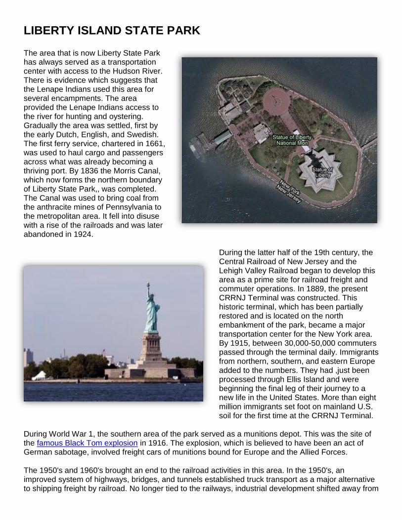
LIBERTY ISLAND STATE PARK
On the New York Harbor, less than 2,000 feet from the Statue of Liberty, Liberty State Park has served a vital role in the development of New Jersey's metropolitan region and the history of the nation.
During the 19th and early 20th centuries the area that is now Liberty State Park was a major waterfront industrial area with an extensive freight and passenger transportation network. This network became the lifeline of New York City and the harbor area. The heart of this transportation network was the Central Railroad of New Jersey Terminal (CRRNJ), located in the northern portion of the park. The CRRNJ Terminal stands with the Statue of Liberty and Ellis Island to unfold one of this nation's most dramatic stories: the immigration of northern, southern, and eastern Europeans into the United States. After being greeted by the Statue of Liberty and processed at Ellis Island, these immigrants purchased tickets and boarded trains, at the CRRNJ Terminal, that took them to their new homes throughout the United States. The Terminal served these immigrants as the gateway to the realization of their hopes and dreams of a new life in America.
Today, Liberty State Park continues to serve a vital role in the New York Harbor area. As the railroads and industry declined, the land was abandoned and became a desolate dump site. With the development of Liberty State Park came a renaissance of the waterfront. Land with decaying buildings, overgrown tracks and piles of debris was transformed into a modern urban state park. The park was formerly opened on Flag Day, June 14, 1976, as New Jersey's bicentennial gift to the nation. Most of this 1,122 acre park is open space with approximately 300 acres developed for public recreation.
Source: Liberty State Park Official Website URL: http://www.libertystatepark.org/
LIBERTY ISLAND STATE PARK
The area that is now Liberty State Park has always served as a transportation center with access to the Hudson River. There is evidence which suggests that the Lenape Indians used this area for several encampments. The area provided the Lenape Indians access to the river for hunting and oystering. Gradually the area was settled, first by the early Dutch, English, and Swedish. The first ferry service, chartered in 1661, was used to haul cargo and passengers across what was already becoming a thriving port. By 1836 the Morris Canal, which now forms the northern boundary of Liberty State Park,, was completed. The Canal was used to bring coal from the anthracite mines of Pennsylvania to the metropolitan area. It fell into disuse with a rise of the railroads and was later abandoned in 1924.
During the latter half of the 19th century, the Central Railroad of New Jersey and the Lehigh Valley Railroad began to develop this area as a prime site for railroad freight and commuter operations. In 1889, the present CRRNJ Terminal was constructed. This historic terminal, which has been partially restored and is located on the north embankment of the park, became a major transportation center for the New York area. By 1915, between 30,000-50,000 commuters passed through the terminal daily. Immigrants from northern, southern, and eastern Europe added to the numbers. They had ,just been processed through Ellis Island and were beginning the final leg of their journey to a new life in the United States. More than eight million immigrants set foot on mainland U.S. soil for the first time at the CRRNJ Terminal.
During World War 1, the southern area of the park served as a munitions depot. This was the site of the famous Black Tom explosion in 1916. The explosion, which is believed to have been an act of German sabotage, involved freight cars of munitions bound for Europe and the Allied Forces.
The 1950's and 1960's brought an end to the railroad activities in this area. In the 1950's, an improved system of highways, bridges, and tunnels established truck transport as a major alternative to shipping freight by railroad. No longer tied to the railways, industrial development shifted away from
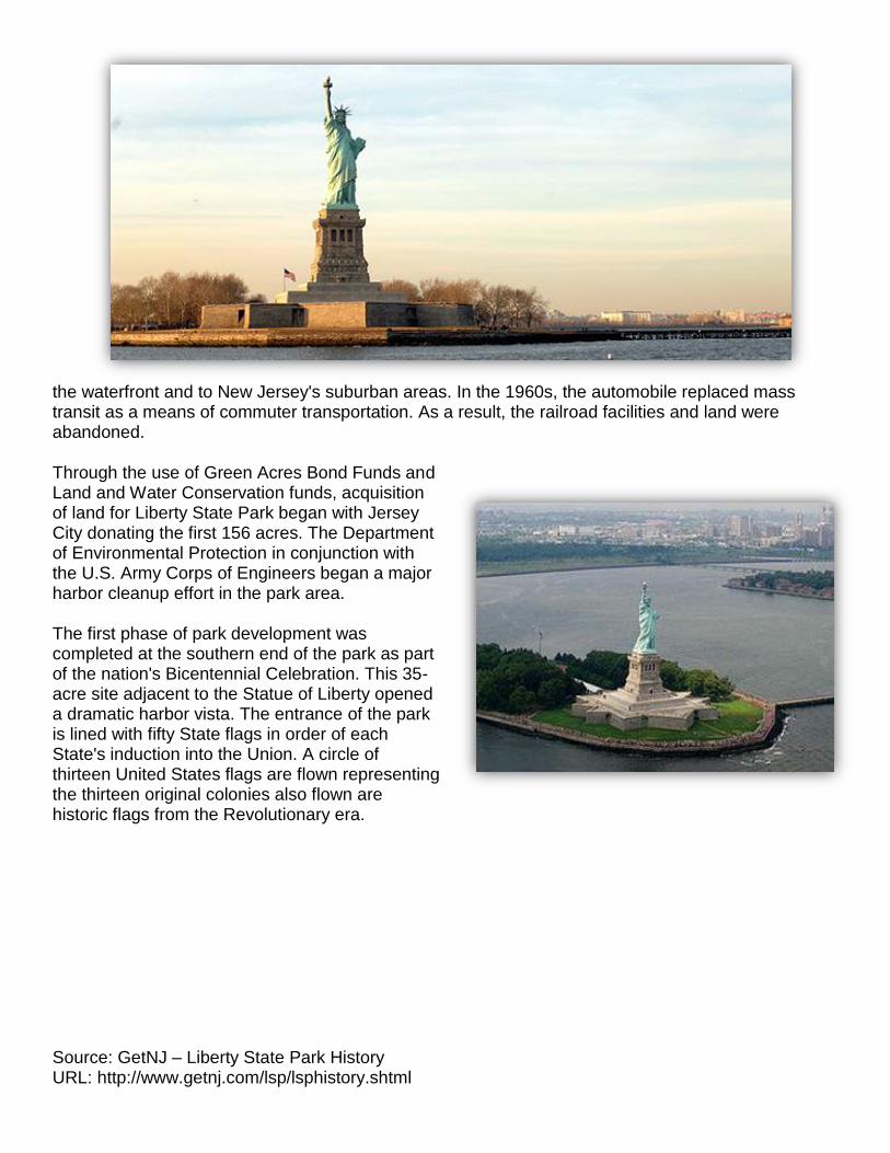
the waterfront and to New Jersey's suburban areas. In the 1960s, the automobile replaced mass transit as a means of commuter transportation. As a result, the railroad facilities and land were abandoned.
Through the use of Green Acres Bond Funds and Land and Water Conservation funds, acquisition of land for Liberty State Park began with Jersey City donating the first 156 acres. The Department of Environmental Protection in conjunction with the U.S. Army Corps of Engineers began a major harbor cleanup effort in the park area.
The first phase of park development was completed at the southern end of the park as part of the nation's Bicentennial Celebration. This 35-acre site adjacent to the Statue of Liberty opened a dramatic harbor vista. The entrance of the park is lined with fifty State flags in order of each State's induction into the Union. A circle of thirteen United States flags are flown representing the thirteen original colonies also flown are historic flags from the Revolutionary era.
Source: GetNJ – Liberty State Park History URL: http://www.getnj.com/lsp/lsphistory.shtml
U.S. ARMY CORPS OF ENGINEERS – NEW YORK DISTRICT 26 FEDERAL PLAZA, NEW YORK, NY 10278-0090
WWW.NAN.USACE.ARMY.MIL
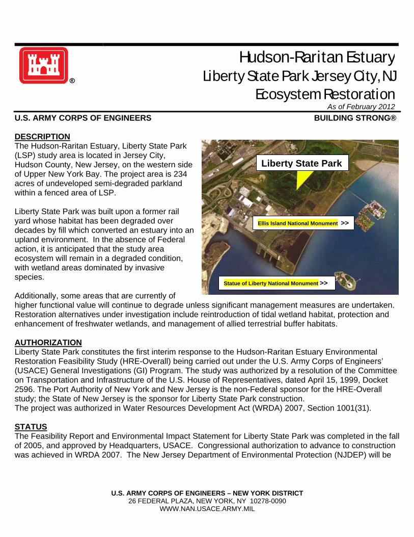
Hudson-Raritan Estuary Liberty State Park Jersey City, NJ
Ecosystem Restoration As of February 2012
U.S. ARMY CORPS OF ENGINEERS BUILDING STRONG® DESCRIPTION The Hudson-Raritan Estuary, Liberty State Park (LSP) study area is located in Jersey City, Hudson County, New Jersey, on the western side of Upper New York Bay. The project area is 234 acres of undeveloped semi-degraded parkland within a fenced area of LSP. Liberty State Park was built upon a former rail yard whose habitat has been degraded over decades by fill which converted an estuary into an upland environment. In the absence of Federal action, it is anticipated that the study area ecosystem will remain in a degraded condition, with wetland areas dominated by invasive species. Additionally, some areas that are currently of higher functional value will continue to degrade unless significant management measures are undertaken. Restoration alternatives under investigation include reintroduction of tidal wetland habitat, protection and enhancement of freshwater wetlands, and management of allied terrestrial buffer habitats. AUTHORIZATION Liberty State Park constitutes the first interim response to the Hudson-Raritan Estuary Environmental Restoration Feasibility Study (HRE-Overall) being carried out under the U.S. Army Corps of Engineers’ (USACE) General Investigations (GI) Program. The study was authorized by a resolution of the Committee on Transportation and Infrastructure of the U.S. House of Representatives, dated April 15, 1999, Docket 2596. The Port Authority of New York and New Jersey is the non-Federal sponsor for the HRE-Overall study; the State of New Jersey is the sponsor for Liberty State Park construction. The project was authorized in Water Resources Development Act (WRDA) 2007, Section 1001(31). STATUS The Feasibility Report and Environmental Impact Statement for Liberty State Park was completed in the fall of 2005, and approved by Headquarters, USACE. Congressional authorization to advance to construction was achieved in WRDA 2007. The New Jersey Department of Environmental Protection (NJDEP) will be
Liberty State Park
Statue of Liberty National Monument >>
Ellis Island National Monument >>

U.S. ARMY CORPS OF ENGINEERS – NEW YORK DISTRICT 26 FEDERAL PLAZA, NEW YORK, NY 10278-0090
WWW.NAN.USACE.ARMY.MIL
the non-Federal sponsor for the project, and has advanced the Pre-construction and Engineering Design (PED) phase for the freshwater wetlands through the USACE Interagency and International Services (IIS) Program. Contingent upon funding, construction could begin at Liberty State Park at any time. COST Estimated Federal Cost (65%) $20,800,000 Estimated Non-Federal Cost (35%) $11,200,000 Total $32,000,000 CONTACT Lisa Baron, Project Manager, E-mail: [email protected], tel: (917) 790-8306. CONGRESSIONAL INFORMATION NJ U.S. Sen. Robert Menendez NJ U.S. Sen. Frank R. Lautenberg NJ-13 Rep. Albio Sires
waterbody. There are about 450 such relief points along the shores of New York City, and CSOs from these discharge locations can impact water quality in the surrounding receiving waters.
So, how is the NYC Department of Environmental Protect ion (NYCDEP) preventing the discharge of the untreated wastewater to the Harbor Estuary during a rain event? Since the 1950s the City recognized that CSOs had an impact on water quality and began preliminary planning for CSO controls. In 1972 the first CSO retention tank designed to store excess flow for later treatment began operation
The Tidal ExchangeNewsletter of the New York ~ New Jersey Harbor Estuary Program
AUTUMN 2005THIS ISSUE__________
HARBOR ESTUARY NEWS
CONTENTS
1Combined Sewer Overflows
What's Happenning in New York City
Stephane Gibbons and Cathy Yuhas
2Liberty State Park 234-Acre Interior:
Restoring an Urban Oasis HEP Priority Restoration
Site HUR3Greg Remaud
6The Center for
Maritime Systems at Stevens Institute of Technology
Castle Point on Hudson, Hoboken, New JerseyDr. Michael S. Bruno
8Species ProfileSand Shrimp
Crangon septemspinosaKatie McCrone
Why does New York Ci ty need to aba te their combined sewer
overflows? In this city of 8 million people spread across 200,000 acres, 14 water pollution control plants (WPCPs) are designed to treat up to 1.8 billion gallons of dry weather flow per day - collected by more than 6,000 miles of sewers - with the ability to treat twice this flow during wet weather. However, during a rain event of about one-tenth of an inch, the collection system cannot convey the entire volume of both the stormwater and the sanitary flow to the WPCPs. The excess is therefore discharged as Combined Sewer Overflows (CSOs) into a receiving
Combined Sewer OverflowsWhat’s Happening in New York CityStephane Gibbons and Cathy Yuhas
A CSO outfall in the Bowery Bay drainage area. Photo courtesy of Dennis Scannell, Hydroqual, Inc.
(continued on page 4)
New York – New JerseyHarbor Estuary Program
DirectorRobert NymanUS EPA, Region II
Outreach CoordinatorLaura BartovicsNew York Sea Grant
Technical SpecialistCathy YuhasNew Jersey Sea Grant
Program AssociateJoel BanslabenNew England Interstate Water Pollution Control Commission
The Tidal Exchange – Autumn 2005
EditorsLaura Bartovics, NYSGJeff Myers, NYS DECKerry Kirk Pflugh, NJ DEPRobert Nyman, EPA HEP OfficeCathy Yuhas, NJSGJoel Banslaben, NEIWPCC
The Tidal Exchange is a publication of the New York – New Jersey Harbor Estuary Program (HEP), a partnership of federal, state and local governments, scientists and citizens working together to protect and restore the natural resources of the estuary. The purpose of the newsletter is to promote an informative dialog on issues related to the Harbor Estuary Program.
The HEP is sponsored by the States of New York and New Jersey and the US Environmental Protection Agency. The HEP Management Committee consists of representatives from the US EPA, NJ DEP, NYS DEC, NY and NJ local governments, US ACE, US DOI, NOAA, Port Authority of NY & NJ, Interstate Environmental Commission, NJ Harbor Dischargers Group, NYS DOS, Science & Technical Advisory Committee and Citizens Advisory Committee.
The Tidal Exchange is produced and printed by New York Sea Grant (NYSG) under a cooperative agreement with the US EPA (#CE982247-01). The viewpoints expressed here do not necessarily represent those of NYSG, US EPA or the HEP Management Committee, nor does mention of trade names, commercial products or causes constitute endorsement or recommendation for use.
Printed on 100% Post-consumerRecycled Paper Processed Chlorine-free
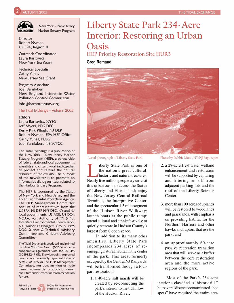
Liberty State Park is one of the nation’s great cultural, historic and natural treasures.
Nearly five million people a year visit this urban oasis to access the Statue of Liberty and Ellis Island; enjoy the New Jersey Central Railroad Terminal, the Interpretive Center, and the spectacular 1.5 mile segment of the Hudson River Walkway; launch boats at the public ramp; attend cultural and ethnic festivals; or quietly recreate in Hudson County’s largest formal open space.
In addition to its many other amenities, Liberty State Park encompasses 234 acres of re-emerging natural habitat in the center of the park. This area, formerly occupied by the Central NJ Railyards, will be transformed through a four-part restoration:
1. a 40-acre salt marsh will be created by re-connecting the park’s interior to the tidal flow of the Hudson River;
2. a 28-acre freshwater wetland enhancement and restoration will be supported by capturing and filtering run-off from adjacent parking lots and the roof of the Liberty Science Center;
3. more than 100 acres of uplands will be restored to woodlands and grasslands, with emphasis on providing habitat for the Northern Harriers and other hawks and raptors that use the park; and
4. an approximately 60-acre passive recreation transition area that will serve as a buffer between the core restoration area and the more active regions of the park.
Most of the Park’s 234-acre interior is classified as “historic fill,” but several discreet contaminated “hot spots” have required the entire area
AUTUMN 2005 THE TIDAL EXCHANGE2
Liberty State Park 234-Acre Interior: Restoring an Urban Oasis HEP Priority Restoration Site HUR3Greg Remaud
Aerial photograph of Liberty State Park Photo by Debbie Mans, NY/NJ Baykeeper
initiative, this restoration project is getting off the drawing table. Commissioner Campbell, bucking industry lobbyists, has resuscitated a nearly dead program that makes polluters pay for their environmental damages beyond just the cost of clean up. Ten million dollars in NRD settlement funds were directed to Liberty State Park by the Commissioner and former NJDEP Senior Policy Advisor, Marc Matsil,
to be fenced off. The contaminated soil will be removed and entombed during the restoration, allowing all 234 acres to be opened for public access.
A New Era at Liberty State Park
This restoration is part of the new era at Liberty State Park formally ushered in with the creation of a Public Advisory Committee through a 2003 NJ Department of Environmental Protection (NJDEP) Policy Directive. The Committee is chaired by Frank Gallagher (NJDEP Parks and Forestry) and includes leaders like Sam Pesin (The Friends of Liberty State Park), Emlyn Koster and Connie Clamen (Liberty Science Center), NY/NJ Baykeeper and NJ Audubon Society. The Committee has made an extraordinary effort to integrate and link the Park’s many amenities while preserving and restoring its natural features.
Feasibility Study Makes Funding Possible
US Representative Robert Menendez secured $5.2 million for the United States Army Corps of Engineers (USACE) Hudson-Raritan Estuary Ecosystem Restoration Study that emphasized Liberty State Park as a top priority. This, along with the local match provided by the Port Authority of NY & NJ, made the completion of the Feasibility Study possible.
The Feasibility Study produced good news. First, the restoration conceptual plan was indeed sound and implementable. And, within the realm of large-scale restoration plans, the project was found to be cost effective and affordable. In other words, it meant that the Advisory Committee and project partners would now have to figure out how to come up with $30 million to complete this grand green vision.
Thanks to NJDEP Commissioner Bradley Campbell’s progressive Natural Resource Damages (NRD)
THE TIDAL EXCHANGE AUTUMN 2005 3
because the interior restoration addresses an environmental injury similar to NRD damages in a locally impacted area.
In addition, NY/NJ Baykeeper partnered with the NJDEP Parks and Forestry to gain an additional $1.5 million from the New Jersey Freshwater Wetland Mitigation Council. In a short time partners have accumulated $11.5 million, ready to
(continued on page 7)
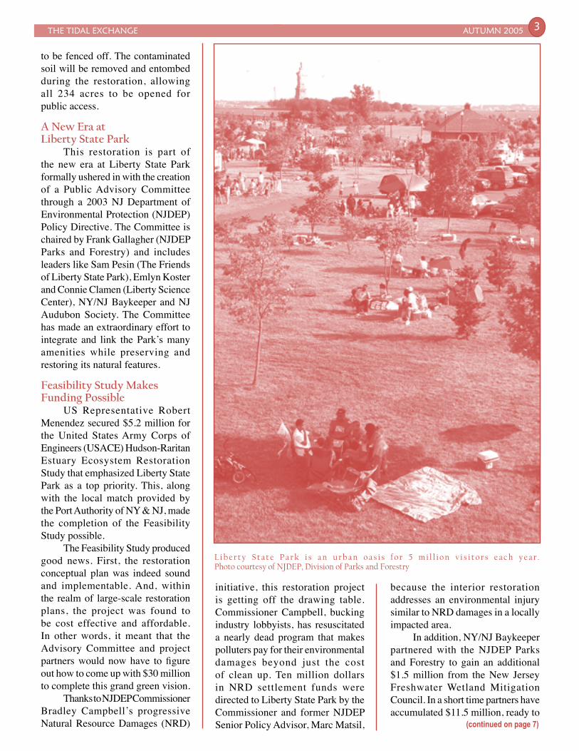
L i b e r t y S t a t e P a r k i s a n u r b a n o a s i s f o r 5 m i l l i o n v i s i t o r s e a c h y e a r . Photo courtesy of NJDEP, Division of Parks and Forestry
AUTUMN 2005 THE TIDAL EXCHANGE4
2004 Administrative CSO Consent Order (2004 Consent Order), which requires the City to adopt a more comprehensive watershed-based approach, and to incorporate existing facility plans and other system improvements into the waterbody/watershed-based long-term CSO control plans (LTCPs). This new approach considers other potential water pollution control initiatives, such as;
• Evaluating cost-effective ways to control CSOs when evaluating upgrades to a WPCP or pump station;
• Providing additional facilities at the Hunts Point, Newtown Creek, 26th Ward, and Jamaica
at Spring Creek in Brooklyn. That same year the Federal Clean Water Act, which required 85% removal of conventional pollutants for all plant discharges, gave unprecedented funding for pollution control plants to achieve secondary treatment at new and existing plants. However, little or no funds were earmarked for the CSO problem. Nonetheless, in 1975 a “208 Study” was initiated and concluded that CSOs had no significant impact on the open waters but had significantly impacted the tributaries.
The City was divided into eight planning areas: the East River, Jamaica Bay, Inner and Outer Harbors, Flushing Bay, Paerdegat Basin, Newtown Creek, and the Jamaica tributaries. In 1980 the Regulator Improvement Project (RIP) began, followed in 1984 by the Flushing Bay CSO Facility Planning project. From the mid-1980s through the 1990s DEP continued the complex issues of CSO planning and conducted numerous City-wide floatable investigations and implemented a number of controls. The City developed its Nine Minimum Control Program and undertook other water quality improvement projects like storm water permitting studies and wastewater treatment upgrades. However, in 1988 the New York State Department of Environmental Conservation (NYS DEC) issued SPDES permits which required the City to address the CSO problem. In 1992, the City was found to be in violation of the 1988 SPDES permit and as a result entered into the 1992 Consent Order for failure to meet the deadlines imposed for initiating and completing the facility plans.
The CSO abatement program resulting from the 1992 Consent Order focused on engineered solutions for CSO abatement, including retention facilities, WPCP and collection system improvements, and floatables control. In 2004 NYS DEC and NYCDEP renegotiated and issued the
Combined Sewer Overflows(from page 1)
WPCPs in order to treat more flow at the treatment plant;
• Enlarging the Gowanus Canal and Avenue V Pumping Stations to direct more combined sewage into the interceptors and away from the local receiving waters, and
• Providing centralized treatment of CSOs.
The 2004 Consent Order also includes other cost-effective methods that will improve water quality, such as;
• Use of flushing tunnels;
• Sewer cleaning;
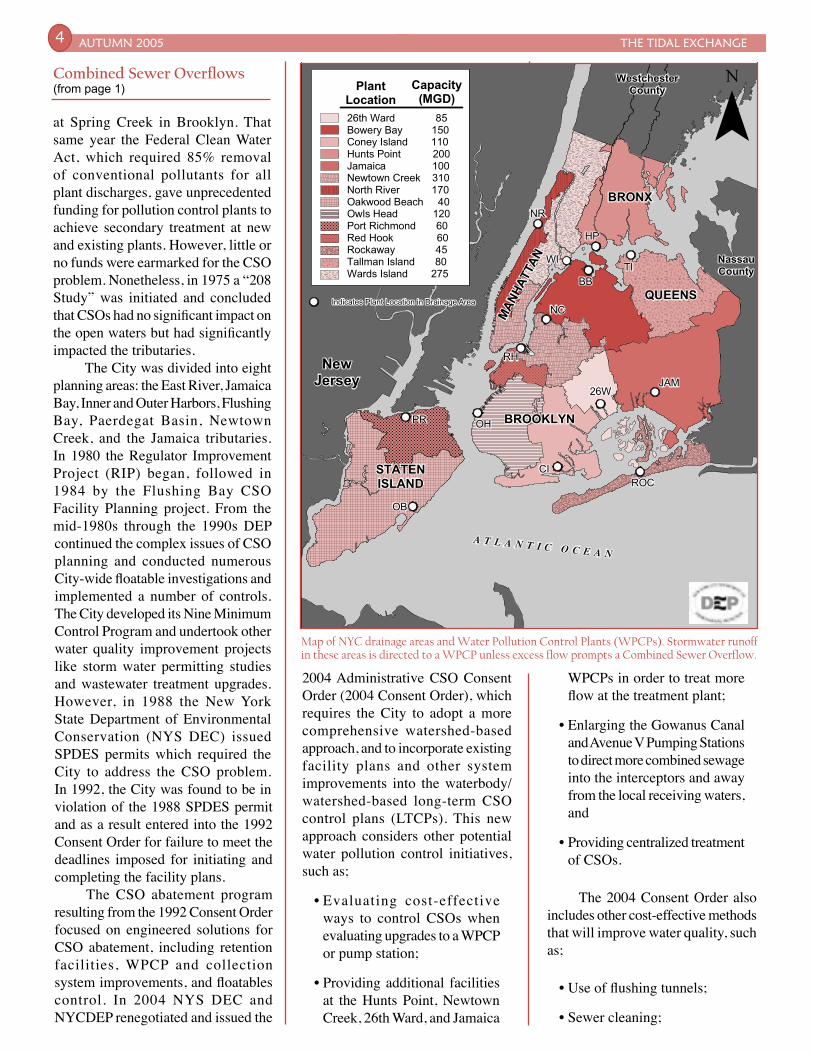
Map of NYC drainage areas and Water Pollution Control Plants (WPCPs). Stormwater runoff in these areas is directed to a WPCP unless excess flow prompts a Combined Sewer Overflow.
PR
OB
CI
OH
RH
NC
BBTI
HP
WI
NR
26W
ROC
JAM
BRONX
QUEENS
BROOKLYN
STATENISLAND
A T L A N T I C O C E A N
NewJersey
WestchesterCounty
NassauCounty
MANHATTAN
PR
OB
CI
OH
RH
NC
BBTI
HP
WI
NR
26W
ROC
JAM
BRONX
QUEENS
BROOKLYN
STATENISLAND
A T L A N T I C O C E A N
NewJersey
WestchesterCounty
NassauCounty
MANHATTAN
Indicates Plant Location in Drainage Area
26th Ward 85Bowery Bay 150Coney Island 110Hunts Point 200Jamaica 100Newtown Creek 310North River 170Oakwood Beach 40Owls Head 120Port Richmond 60Red Hook 60Rockaway 45Tallman Island 80Wards Island 275
PlantLocation
Capacity(MGD)
goals in as flexible and cost-effective a manner as possible.
The Policy – developed through negotiations among municipal organizations, environmental groups, and State agencies – contains four fundamental principles to ensure that CSO controls are cost-effective and meet local environmental objectives. These principals include:
• Clear levels of control to meet health and environmental objectives;
• Flexibility to consider the site-specific nature of CSOs and find the most cost-effective way to control them;
• Phased implementation of CSO controls to accommodate a communi ty’s f inanc ia l capability;
• Review and revision of water quality standards during the development of CSO control plans to reflect the site-specific wet weather impacts of CSOs.
THE TIDAL EXCHANGE AUTUMN 2005 5
• In-stream aeration;
• Sewer separation in large areas of southeastern Queens;
• F loa t ab le s con ta inmen t booms;
• Skimmer boats, and
• Catch basin modifications to allow for hooding of remaining unimproved catch basins.
The 2004 Consent Order consists of 30 different project components versus the 8 retention facilities projects in the 1992 Consent Order.
Benefits of the projects in the 2004 Consent Order include:
• An increase in the amount of wet weather flow being treated, from an estimated level of 70.2% (1992 Consent Order) to an estimated level of 73.0% (2004 Consent Order);
• A reduction of untreated CSO discharges, from an estimated level of 32.4 billion gallons a year (1992 Consent Order) to an estimated level of 27.25 billion gallons a year (2004 Consent Order);
• A d d e d e n v i r o n m e n t a l benefits;
• Improved water quality, and
• Consistency with the current EPA policy on long-term CSO control.
The 2004 Consent Order also includes a City-wide LTCP that will be completed by 2017. The LTCP is being developed to meet the fishable and swimmable goals of the Clean Water Act through attainment of waterbody use classifications and corresponding water quality standards. Key Components of the LTCP include:
• Conducting drainage basin specific waterbody/watershed facility plans;
• Designing and constructing facilities that will meet the designated standard and/or recommending alternative uses for that waterbody;
• Recommending structural measures such as in-line storage, storage tanks, wet weather optimization, and regulator improvements that will facilitate use attainment, and
• Compiling all of the completed drainage basin facility plans into a comprehensive City-wide LTCP.
Combined Sewer Overflow discharges have been identified as a national compliance priority. As such a national CSO Control Policy was put in place in 1994 to address the CSO problem. The Policy provides guidance on how communities with combined sewer systems can meet Clean Water Act
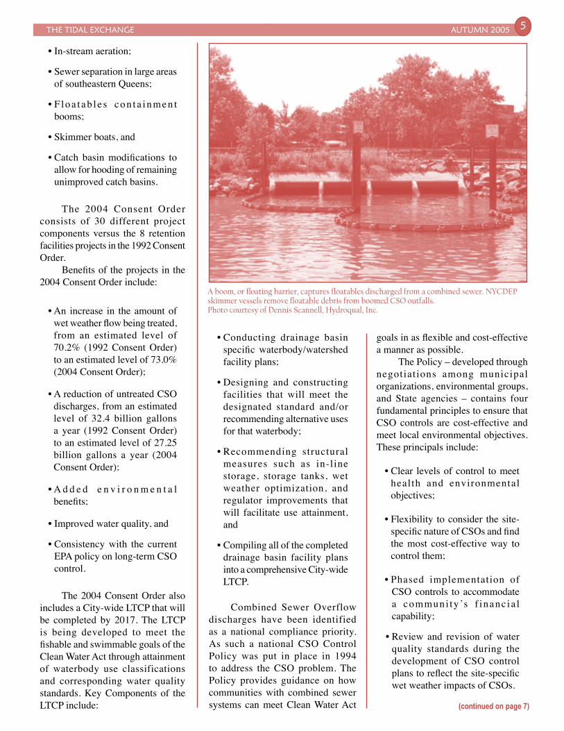
A boom, or floating barrier, captures floatables discharged from a combined sewer. NYCDEP skimmer vessels remove floatable debris from boomed CSO outfalls. Photo courtesy of Dennis Scannell, Hydroqual, Inc.
(continued on page 7)

Stevens Institute of Technology’s involvement in maritime issues dates to the founding family,
who among other achievements pioneered advances in steamship and propeller design in the early 1800’s
AUTUMN 2005 THE TIDAL EXCHANGE6
and built the Yacht America, famous for initiating the America’s Cup competition in 1851. This nautical tradition continued with the founding in 1935 of the Davidson Laboratory, still one of the world’s leading facilities for naval architecture research. It is worthwhile to note that the Laboratory’s renowned towing tank complex is presently undergoing a major renovation that will expand the existing tank to 320 feet long, 16 feet wide and 8 feet deep. When combined with improved instrumentation, glass walls for viewing and photography, and public access improvements, the facility will further enhance the Laboratory’s contributions to fundamental and applied research in ship design, hydrodynamics and ocean engineering.
The Center for Maritime Systems includes the Davidson Laboratory as well as several new computing and field facilities that together provide significant capabilities for research and education in areas of importance to the New York – New Jersey Harbor Estuary community. Of perhaps most significance is the New York Harbor Observation and Prediction System (NYHOPS), a real-time observation and forecasting system that provides continuous information regarding present ocean and weather conditions at points throughout the Harbor - from Sandy Hook Bay north to the George Washington Bridge, along with locations in the East River and Newark Bay (see Figure 1). Computer forecasts of conditions out to 48 hours are also provided, via the ongoing efforts of Stevens Professor Alan F. Blumberg, developer of the widely-used ocean forecasting model known as the Princeton Ocean Model. The real-time data and model forecasts are disseminated to the public via the Internet at
http://onr.dl.stevens-tech.edu/webnyhos3/.
The Center for Maritime Systems is employing the NYHOPS observations and predictions in
The Center for Maritime Systems at Stevens Institute of TechnologyCastle Point on Hudson, Hoboken, New JerseyDr. Michael S. Bruno
Figure 1: Location of sensors in the NYHOPS network. "Partner" sensors are owned and maintained by NOAA/NOS, Rutgers University and The River Project.
*
BLACK = STEVENSORANGE = PARTNERS
THE TIDAL EXCHANGE AUTUMN 2005 7
numerous studies of the physics of the Estuary, including studies of the circulation and sediment transport within the Kills and Newark Bay, and the influence of the built environment on local climate and estuary dynamics. Other engineering investigations that make use of these resources include continuing work in support of safe navigation and the mitigation of shoreline impacts from high-speed vessel traffic. As a consequence of the capabilities and expertise gained over many years of working for and with various members of the maritime community in the Harbor – including NOAA, US Coast Guard, Sandy Hook Pilots, The Port Authority of NY & NJ, NJDOT, NJDEP, NYCDEP, and others – the
be matched 2:1 by the USACE and other sources.
Utilizing State funding, the USACE is now poised to complete the design phase of the project in 2006. This will provide the technical specifications for the restoration. At that time, USACE should provide matching funds for full project implementation from either the Water Resources Development Act or the excessive Feasibility Study budget. Alternatively, NJDEP could team with other partners or move ahead independently with a phased restoration over a longer period of time.
What Could Have Been, What Will Be
As this community vision moves forward, it is important to note that the first step toward this restoration was site preservation. It was not so long ago, during the tenure of the Liberty State Park Development Corporation, that the interior of the park was under tremendous pressure for commercial development including a golf course and water park.
NYCDEP initiated a Use and Standards Attainment (USA) program in 1998 to evaluate the effectiveness of engineering efforts to bring the City into compliance with the regulatory requirements of the national CSO Control Policy. The City’s USA program uses the US Environmental Protection Agency (EPA) Watershed Approach Framework. (i.e., looks at other sources of pollution besides CSOs); relies on stakeholder involvement; considers the actual and potential use of a waterbody and its Water Quality Standards; and serves as a technical resource for potential waterbody-specific Use Attainability Analysis. There are 26 open water and tributary USA project areas in the Harbor Estuary. This work is now being folded into the LTCP development.
Modeling of CSO impacts on water quality, through use of the System-wide Eutrophication Model (SWEM) and other NYC Tributary CSO Models, is a significant component of the USA effort. The CSO Models in turn have led to the By-Pass Model, which predicts the impacts of unanticipated discharges. Both the Long Island Sound Study and NY-NJ Harbor Estuary Program (HEP) have adopted SWEM. HEP is currently utilizing SWEM and the CSO Tributary Models to evaluate Total Maximum Daily Loads (TMDLs) for pathogens, toxics, and nutrients. v
Stephane Gibbons is an Executive Project Manager with NYCDEP’s Bureau of Engineering, Design & Construction, Division of Water Quality Improvement.
Cathy Yuhas is the Technical Specialist for the NY-NJ Harbor Estuary Program and a NJ Sea Grant Extension Agent with the New Jersey Marine Sciences Consortium.
Combined Sewer Overflows(from page 5)
Instead, unparalleled urban environmental education and wildlife viewing will take place along selected nature paths within the core restoration area, with passive recreation in the surrounding transition area.
“The restoration of the Interior of Liberty State Park will be among the nation’s greatest urban natural restorations,” states Congressman Robert Menendez. “It will bring to bear the vision of the late Morris Pesin, and create an urban oasis on one of the most densely populated areas in the country. I’m honored to work with the Baykeeper and all the partners to make Liberty State Park greener for all of the public.” v
Greg Remaud, Preservation Director, NY/NJ Baykeeper, has served as President of the Liberty State Park Conservancy for the past five years and sits on the LSP Public Advisory Committee. The Baykeeper’s mission is to protect, preserve, and restore the ecological integrity and productivity of the Hudson-Raritan Estuary. For more than a decade it has played a lead role in preserving and restoring Liberty State Park’s natural resources.
Center for Maritime Systems is well equipped to respond to the pressing needs of the community. The inclusion of undergraduate and graduate students in these challenging projects further enhances the program’s impact by training the next generation of Harbor scientists and engineers. v
Dr. Michael S. Bruno is Director of the Center for Maritime Systems and Professor of Ocean Engineering at Stevens Institute of Technology. His research and teaching interests include ocean observation systems, coastal ocean dynamics, maritime security, and estuary and ocean water quality. He is the author of more than 80 technical publications in various aspects of the field.
Liberty State Park(from page 3)
AUTUMN 2005 THE TIDAL EXCHANGE8
Would you like to change your address or add someone to
our mailing list?
Provide changes or additions be-low, cut out or copy this section (include mailing label to the right so we can find you in our records) and mail to the Harbor Estuary Program Office, 290 Broadway, 24th Floor, New York, NY, 10007.________________________________
________________________________
________________________________
________________________________
First-Class MailPostage & Fees PaidEPAPermit No. G-35
www.harborestuary.org
290 Broadway, 24th FloorNew York, New York 10007
New York - New JerseyHarbor Estuary Program
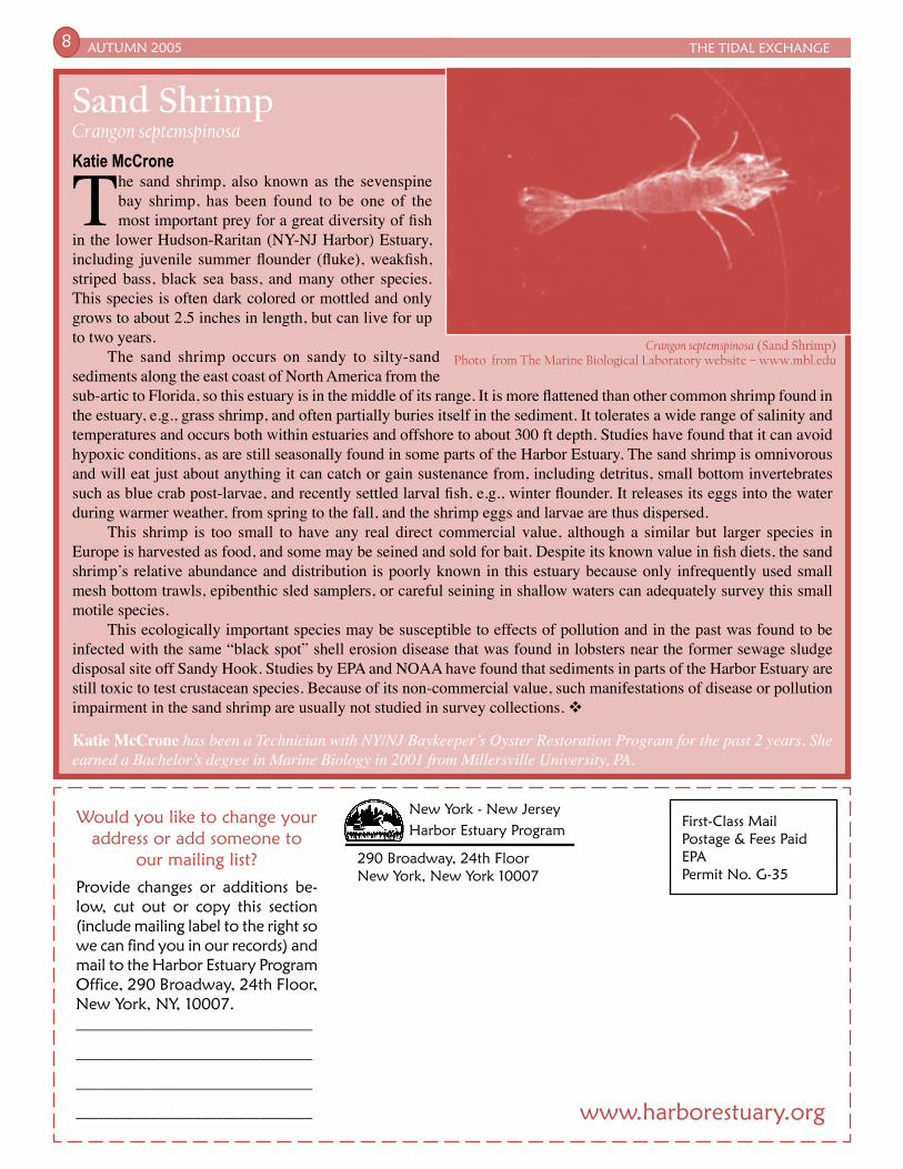
Sand ShrimpCrangon septemspinosaKatie McCrone
The sand shrimp, also known as the sevenspine bay shrimp, has been found to be one of the most important prey for a great diversity of fish
in the lower Hudson-Raritan (NY-NJ Harbor) Estuary, including juvenile summer flounder (fluke), weakfish, striped bass, black sea bass, and many other species. This species is often dark colored or mottled and only grows to about 2.5 inches in length, but can live for up to two years.
The sand shrimp occurs on sandy to silty-sand sediments along the east coast of North America from the sub-artic to Florida, so this estuary is in the middle of its range. It is more flattened than other common shrimp found in the estuary, e.g., grass shrimp, and often partially buries itself in the sediment. It tolerates a wide range of salinity and temperatures and occurs both within estuaries and offshore to about 300 ft depth. Studies have found that it can avoid hypoxic conditions, as are still seasonally found in some parts of the Harbor Estuary. The sand shrimp is omnivorous and will eat just about anything it can catch or gain sustenance from, including detritus, small bottom invertebrates such as blue crab post-larvae, and recently settled larval fish, e.g., winter flounder. It releases its eggs into the water during warmer weather, from spring to the fall, and the shrimp eggs and larvae are thus dispersed.
This shrimp is too small to have any real direct commercial value, although a similar but larger species in Europe is harvested as food, and some may be seined and sold for bait. Despite its known value in fish diets, the sand shrimp’s relative abundance and distribution is poorly known in this estuary because only infrequently used small mesh bottom trawls, epibenthic sled samplers, or careful seining in shallow waters can adequately survey this small motile species.
This ecologically important species may be susceptible to effects of pollution and in the past was found to be infected with the same “black spot” shell erosion disease that was found in lobsters near the former sewage sludge disposal site off Sandy Hook. Studies by EPA and NOAA have found that sediments in parts of the Harbor Estuary are still toxic to test crustacean species. Because of its non-commercial value, such manifestations of disease or pollution impairment in the sand shrimp are usually not studied in survey collections. v
Katie McCrone has been a Technician with NY/NJ Baykeeper’s Oyster Restoration Program for the past 2 years. She earned a Bachelor’s degree in Marine Biology in 2001 from Millersville University, PA.
Crangon septemspinosa (Sand Shrimp) Photo from The Marine Biological Laboratory website – www.mbl.edu