lfs annual report vol 42 - lundy field society€¦ · sa4: includes a stone (ntas 10 1 ,121 ) at...
TRANSCRIPT

Rep. Lundy Field Soc 42
THE MEGALITHIC ASTRONOMY OF LUNDY: EVIDENCE FOR THE REMAINS OF A SOLAR CALENDAR
By
R. W. E. FARRAH
South Light, Lundy, GPO Bidcford, North Devon, EX39 2L Y or
4 Railway Cottages, Long Marton, Appleby, Cumbria CA 16 6BY
INTRODUCTION Many will be familiar with the Midsummer Solstice (Sol =sun, stice = stand, the
sun' s "standstill" ) alignment at Stonehenge in which the sun ri ses above the hee l stone, an outlier to the north-east, when viewed from the centre of the circle. Others will know of Newgrange in the Boyne Valley, Ireland, a chambered passage grave aligned to the winter solstice sunrise when the sun 's rays enter the monument through the aperture of a roof box (Patrick 1974). In addition to these well-known monuments, many other megalithic remains in Britain, Ireland and Europe also have astronomical alignments. These are usually found to be significant points in the cycle of the sun and moon, but there is also evidence that the brighter stars were used. The study of thi s subject is given the name Archaeoastronomy.
THE CYCLE OF THE SUN There are two solstices during the year, a summer solstice and a winter solstice. At
the summer solstice the sun reaches its maximum northerly position along the horizon where it rises in the north-east and sets in the north-west . At the winter so lstice the sun has reached its most southerly position, where it rises in the south-east and sets in the south-west (see fig. 1 which gives these positions for the latitude of Stonehenge which is the same as that of Lundy).
The sun can set only withip. !his arc of !he horizon
N
s
The sun can rise only within this arc of the horizon
Fig. 1: The limiting directions of sunrise and sunset for a site with the latitude of Stonehenge (after Wood 1980).
55

N
s
Fig. 2: The celestial sphere (after Wood 1980).
The midpoints between the midsummer sunrise (MSSR) and the midwinter sunrise (MWSR) in the east, and between the midsummer sunset (MSSS) and the midwinter sunset (MWSS) in the west are the points of the equinox. This is when the sun is half-way along the horizon between its risings in the east and its settings in the west. The solstitial positions of the sun diffs: r according to latitude. On Lundy daylight on midsummer's day lasts sixteen and a half hours; the north of Britain, however, has an extra hour of daylight.
The first stage in the process of checking an alignment is to calculate the declination of the sun (ie. the angular distance of a celestial body from the celestial equator) . For this the latitude of a site together with the azimuth and horizon height (altitude) are required. The azimuth is a compass bearing taken from true north; an azimuth of 90 degrees is due east. The horizon height is important because this effects the time it takes a celestial body to app·ear on the horizon. The sea horizon is zero degrees; any land mass above this will effect its appearance time. The higher the horizon's altitude, the longer it will take to appear.
Fig. 2 shows the path of the sun on the celestial sphere during the course of a year. At the spring equinox the sun is at the position marked by the letter W, crossing the celestial equator as it moves from south to north. At the same time its declination changes from a negative to a positive va lue. From March to June the sun 's declination increases to a maximum value of 23.5 degrees and its position at the summer solst ice is represented by the point X. The path traced out on the celestial sphere by the sun during the remainder of the year is the curve YZW. On this representation WXYZ is the plane of the ea rth' s orbit, and it is tilted to the plane of the equator by the angle of the ecl iptic E.
56
In this paper I have assumed that the megalithic culture on Lundy reflects a knowledge of events happening at Stonehenge and other mainland sites and that megalithic science came to Lundy at a later date because of the island's geographical isolation. But the reverse.could be true, with Lundy a prototype of mainland meg11lithic culture. The effect of the island 's isolation on the community could have led to an introspection which the busier mainland communities would lack. This coupled with the excellent visual horizon for observing the sun's yearly cycle could have led independently to the beginnings of a megalithic science. As Renfrew has suggested ( 1971 ), "because people were more isolated on an island and turned in on themselves, if religious beliefs developed, and social beliefs developed, there was an opportunity for them to feed on each other and to develop more intensively" . There is evidence for this in many cases, for example Malta, Easter Island and, closer to home, Orkney. Although its physical remains are slight by comparison, the same could apply on Lundy.
EVIDENCE FOR MEGALITHIC ASTRONOMY ON LUNDY An historic landscape survey of Lundy currently being undertaken by the National
Trust is designed to produce a measured survey of all upstanding archaeological features on the island (Thackray 1989; Claris and Thackray 1990). I have used their fieldwork and specifically the National Tmst Archaeological Survey for its description of the stones and any add itional points of interest concerning their localities. (For a background to the research conducted and described in this paper, cf. Farrah 1992.)
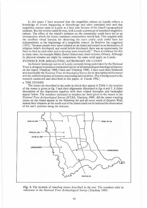
a THE STONES The stones are described in the order in which they appear in Table l ; the location
of the stones is given in fig. 3 and their al ignments illustrated in figs 4 and 5. A fulle r description of the alignments together with their related foresights and backsights appear below. The numbers indicated in brackets are those given to the stones in the National Trust Archaeological Survey (NTAS, Thackray 1989). All the major standing stones on the island appear in the following list and all occur south of Quarter Wall; indeed their situation at the south end of the island could not be bettered for observation of the sun's position along the horizon.
Fig. 3: The location of standing stones described in the text. The numbers refer to references in the National Tmst Archaeological Survey (Thackray 1989).
57

For the purpose of this paper, alignments are defined as follows: an ideal alignment consists of two markers, a foresight and a backsight, the backsight being where the observer usually stands to view the alignment. At single slab si tes where no foresight exists, the alignment is taken from the orientation indicated by the direction of the axis of the stone, the axis being defined as the narrower width as opposed to the broadface. If a stone does not have a clearly defined axis then a reasonab le alignment cannot be deduced. The stones occur with in such alignments as follows:
S tone Al ignment (SA) I : Includes a standing stone (NTAS 10 I ,099) on Ackland 's Moor a short distance north-east of the Old Light (fig. 6a). It is a triangular slab of weathered granite 1.4m high by 1. 2m wide at the base and 0.23m across at the top . The stone is earthfast and a slight bank runs between this stone and another (NTAS 101 , 100) to the north. No sati sfactory explanation has been found for the p lacing of these stones. They could as easily be cattle rubbing stones or old field boundary markers, as having any ritual purpose.
SA2: Includes a standing stone (NTAS 101 , 100) on Ackland 's Moor about lOOm north ofNTAS 10 I ,099. It is a massive boulder which is not earthfast , being fixed in position by small stones. It is unweathered, measures I. Sm high by 1.42m wide and 0. 75m across the axi s. It stands at the south-west end of a line of stones demarcating one side of the runway of the old airfie ld .
SA3: Includes a standing stone unrecorded in the NTAS and located at the northern end of the Tent F ield in direct line between Beacon Hill and Castle Hill. It is now prone but was standing until recently (as shown in a photograph by A.] .Dollar, 1930) and the hole in which it stood is clearly visible . It has dimensions of 1.4m high , 2m wide and an axis measuring O.Sm. The stone has cup-like marks on its on ly visible surface.
SA4: Includes a stone (NTAS 10 1 ,121 ) at the south-west corner of the Tent Field which is now prone. The NTAS suggests thi s could be a cattle rubbing stone, an isolated remnant of a former field boundary or evidence of rituali stic pract ice (Thackray 1989,97). It is 2.28m high and is pillar-shaped with sides of 0. 7m and a possible axi s of 05m. ·
SAS: I ncludes a standing stone unrecorded in the NTAS. It is located a short di stance from Friar's Garden approximately halfway across West Side Field just to the side of the cliff path. This stone is not ea rthfast and packing stones can be seen at its base. It is now leaning at an acute angle. It is 1.4m high , 1. 2m wide and measures 0.54m across the ax is (fig. 6b).
SA6: Includes stones NTAS 101,099 and NTAS 101 , 100 and cu lminates in a cairn (NTAS 10 I ,094) to the north. The cairn is a grass-covered stony mound which measures 8m across and is set on a high point to the north of Ackland' s Moor. Exactly halfway between NTAS I 0 I, I 00 and cai rn NTAS I 0 I ,094 is another cairn-like mound with two stones now prone. To the west of cairn (NTAS I 0 I ,094) is a large flat-bottomed stone.
SA7: Includes a stone (NTAS 10 1, 141 ) in Brick Field. It is located north of the boundary of Brick and Tillage Fields about 30m in from the eastern edge of the field. The stone is carthfast and cou ld be the only remaining one of several large, upright stones which were extant in 1932 and were considered by Dollar to be menhirs. I t has a height of 1.6m, is I. Sm wide and has an axis of 0.29m.
SA8: Includes stone NTAS 101 , 121 described in SA4 (above) and a stone unrecorded and described in SA3.
b THE ALIGNMENTS The alignments related to the stones described in the preceding sect ion arc now
described. All the result s arc based on original fie ldwork comprising observations and photographs. The fieldwork connected with the calculated declinations was carried out with the instruction of Gerald Hawkins. True azimuths were deri ved by app lying the variation corrected to the measured magnetic bearings and the values assessed by Hawkins using the " Stonehenge" programme which appears as an appendix to Mi11ds1eps 10 1he Cos111os (Hawkins 1983).
~8

358"
,\\I~ CAIRN
;.,,,' SS1324H78
210· ----+--+--+---go·
SS531453 229,..
I
59"
~ SA-4•
SA4b
SAS
Fig. 4: Details of stone alignments described in the text.
59

In the case of SAl and SA2 (fig.4 ) it was suspected that the ax is of stone NTAS 101,099 in SA I was orientated towards MSSR after taking a bearing with a prismatic compass. The sun indeed rose from its sea horizon along the axis of the stone as it did along the axis of stone NTAS 101 , 100 in SA2, lOOm to the north . These two stones appear related; when standing at one it is natural to look at the other. The NT AS suggests that, " no sat isfactory explanation has been found for the placing of these stones" (Thackray 1989, 75); their deliberate alignment with MSSR is one possibility although it must be stressed that no foresight or backsight exists for stone NT AS 101,099 (fig. 6a). There is the poss ibility that the building of the Old Light on Beacon Hill has disturbed evidence; this wi ll be discussed further below. A further possibility is the significance of the bearing of 56 degrees along the axis to the north-east which hits the back-marker for stone NTAS 101 , 14 1 in SA7. However, the distance, approximately 650m, does not seem to be practical and one stone cannot be seen from the other although Thorn has suggested that a sigh tline over such a di stance is poss ible wit h one or two observers standing in between (personal communication). Standing stone NTAS 101 , 100 in SA2 does have a fores ight c.200m along its axis of 59 degrees which can clearly be seen on the island horizon. The stone is now broken into three pieces although the base is still in situ. Why, therefore, two stones connected with the same MSSR? The answer could be that SA2 is an improvement on SA l, a poss ibility born out by the stones themselves . Stone NT AS I 0 I ,099 is weathered and looks the older of the two. SA2 was made to the near horizon for better observation while SA I would have had problems with horizon conditions, for example fog and mist.
The next standing stone, unrecorded in the NTAS, is in SA3 (fig. 5) and was first identified by Langham (1975). When the survey stakes were initially placed to mark the alignment, it was shown to run to the right of Castle Hill looking south. Again there is no accurate fores ight or backsight on Beacon Hill and the azimuth was calculated from the centre of the hill as seen from the standing stone. It appears to be more accurately aligned in the MSSS direction on Beacon Hill. Beacon Hill is a significant geographical feature, the presence of which appears to dominate the former three alignments. The fact that SA3 is so accurate could help substantiate the point that a poss ible backsight for SAl was destroyed during construction of the Old Light. The name Beacon Hill is thought to derive from a former fire beacon, poss ibly of medieval origin, and could have been associated with the di splay of ancient coastal lights. It is also worth mentioning the tradition of beacon fires connected with both solstices which still take place in some parts of Britain, Ireland and more widely across Europe. The Reverend Donald McQueen, writing in Ireland in 1782, desc ribed how, during the night before midsummer morning, the country was lit up for miles by fires " in honour of the Sun" (Hadingham 1975, 182).
The next three examples, SA4a, SA4b and SAS (fig. 4), are all equinox alignments. SA4a and SA4b are both concerned with the standing stone in the south-west corner of the Tent Field (NTAS I 0 I , 121 ). This stone is now prone and, on the assumption that standing stones often fall flat-face, a magnetic bearing of 180 degrees was taken along the centre of the stone's length (SA4a) suggesting azimuths of 90 degrees and 270 degrees, which are very close to equinox. The azimuth of 90 degrees aligns with a distant mainlant foresight, (NGR SS53!453), the highest point visible from Lundy, situated c.2km south of Il fracombe on the North D evon coast. It is a di stinctive geographical feature with the appearance of a class ic notch foresight; it is 23 miles di stant at a height of 229m. The calculated declination for this marker was +3.6 degrees, a discrepancy which may be"explained by the fact that the sun at the equinox is moving along the horizon at its fastest and is therefore diffi cult to mark accurately. The alignment had therefore been taken to the nearest significant feature to the equinox on the hori zon. However, during the autumn months a previously overlooked stone (SA4b) was found lying prone in the shadow of a drystone wa ll. This is about half the height of the larger stone and about 4. Sm away. It has a tapered end which cou ld be the base of the stone. Magnetic bearings were taken on all poss ible azimuths. The bearing from base to base gives a very accurate declination of -0.4; all the others have no astronomical significance. It would be interesting if archaeologica l work was able to confirm that the bases are in fact the ends
60

13'
352.50' I '\ ~ .....
-:;,"' I
SI>.T SA8
SA3
Fig. 5: Details of stone alignments described in the text.
61

of the stones wh ich stood in the ground; certainly the astronomical ev idence suggests they were .
SAS marks the equinox sunset (fig. 6b). The axis of the stone is orientated giving a magnetic bearing of 277 degrees forward (±4 degrees) and 97 degrees reve rse (±4 degrees), a declination of +0.2 in the forward direction over looking the sea hori zon. The magnetic bearing was taken on the equinox sunset as observed; this is the only stone on which this procedure was carried out. There is no foresight or backsight evident for thi s alignment and this is the reason for the ±4 degrees error. A further stone on this alignment servives at the edge of the Friar's Garden, the southern half of which is cut by the alignment. This is almost buried but forms a mound which is plainly visible.
The last three stone alignments, SA6, SA 7 and SA8, have no clear astronomical significance; curiously, however, they all give similar declinations. While carrying out the fie ldwork connected with these alignments it appeared that they were not aligned to the more common astronomical events in the calendar. SA6 (fig. 4), with stone NTAS 099 in the foreground and cairn NTAS 094 in the far distance on island horizon, is wellknown and described by Gardner ( 1972,27) who suggests that, "the monoliths probably define the boundary of ploughland as a slight lyncher follows the line". The alignment comprises, from north to south, a cai rn (NTAS 094), a cairn-like mound with two stones clearly visible but prone at NGR SS 13254460 located exactly half-way between cairn 094 and stone NT AS 100, and lastly stone NTAS 099 at the southerly end. Both stones 099 and I 00 have been previously described and shown to be aligned along their axis to MSSR. When the survey stakes were erected the line was shown to pass between the two stones on the cairn-like mound, a feature not recorded by the NTAS.
SA 7 includes the impress ive Brick Field standing stone (fig. 5). This is the only one of all the Lundy stones which does not seem to have an astronomical alignment and, as Dollar has observed, is one of several which were ex tant in 1932 and were considered by him to be menhirs (Thackray 1989, 121). The alignment is marked by a weathered and broken stone at NGR SS 13824480 50. 3m to the north which lies directly on bearing 56 degrees in SA l.
The final alignment, SA8, includes the stone mentioned in SA3 at the north end of Tent Field and stone TT AS 121 in the south-west corner (fig . 5). The axis of the stone at the north end of Tent Field would have been orientated in the direction of stone NT AS 121 when it was standing. The hole in which it stood is still visib le and gives a clear indication of this orientation.
All of the last three alignments give similar declinations (Table I ) . Of the three, SA6 north of Beacon Hill, could have functioned as a meridian line providing information which would have been of much practical use in an island environment. Standing at the northern cairn looking south, using the cairn as the apex of an approximate isosceles triangle, with the other base angles at SA I and Beacon Hill, magnetic bearings g ive readings of SA6 = 178.5 degrees, Beacon Hill= 188 degrees and the sun at meridan = 184 degrees. Both SA6 and Beacon Hill viewed from the cairn appear as di stinctive terrestrial features making the observation of the sun's meridian easy and precise; the di stance between SAl and Beacon Hill is 80m. The cairn (NT AS I 0 1,094) in the opposite direction to the north , wou ld have provided a di stinctive feature on the island horizon against a clear night sky and could have been used to watch the sequence of stars rising .and se tting, thus acting as timekeepers. As Thom has pointed out, there is a complete sequence marking the early morning hours at midwinter thus providing· a method of knowing the time (Thom 1967, I 05 and 123). These meridian observations and star sequences would also have provided the community in their island environment with time and direction aids for the purposes of navigation on their sea voyages.
CONCLUSION The evidence is strong fo r a solar calendar existing on Lundy and the distribution of
the stones can be shown to be related to their own astronomical alignments. These show an accuracy which points to astronomical observations rather than the approximate alignments of ritual use. There is a good example of the latter in an alignment of cairn
62

a.
b.
Fig. 6: a. Stone (NTAS 101 ,099) in SAl, aligned on the midsummer solstice sunri se above sea horizon; b. Stone (unrecorded in the NTAS) in SAS, aligned on the equinox sunset. (Photographs by the author. )
63

Table I. ORIENTATION OF LUNDY STONES
Stone National Declination Align- Grid M agnetic Azimuth Skyline on Object ment Reference Bearing E ofN Elevat ion Skyline
1327.4435 56° 50.1 0 +23.5 midsummer sunrise
236° 230.1 2.25 -21.7 midwinter sunset?
2 1326.4445 59° 53.1 I +22.9 midsummer sunri se
239° 233.1 0 -22.3 midwinter sunset ?
3 1360.4400 312° 306.1 2.5 +23.6 midsummer sunset
132° 126.1 0.25 -21.9 midwinter sunrise?
4a 1367.4375 90.25 ° 84.35 0.5 +3.6 equinox sunrise
270° 264.1 2.5 -1.9 equinox sunset?
4b 1367 .4375 96.5° 90.6 0.5 -0.4 equinox sunrise
276.5° 270.6 2.5 +2.1 equinox sunset?
5 1322.4406 277 ° 271.1 0.0 +0.2 equinox sunset 970 91.1 1.0 -0.2 equinox sunrise?
6 1324.4476 358.5° 352.1 0.5 +38.4
178.5° 172.1 0.0 -39.0
7 1380.4475 J3 0 7.1 0.0 +37.9
193° 187.1 1.5 -37.3
8 1360.4400 352.5° 346.6 1.5 +38.7
172.5° 166.6 0.25 -37.9
circles on Middle Park which are orientated roughly SW-NE.
Of the nine alignments investigated, six can be shown to have solar alignments and of the remaining three which share the same approximate declinations, the alignment on Ackland's Moor is poss ibly meridian . Of the six standing stones only one, the Brick Field stone (SA 7), is not involved in a solar alignment . SA6 and SA8 are the same, but the latter two contain stones which have astronomical alignments in other d irections. SA6 has stones NTAS 101 ,099 and 101,100, both shown to be orientated towards MSSR; SA6 is also, I believe, a strong candidate for practical use as a meridian line. SA8 concerns the stone in Tent Field, the same stone which is in SA3 and aligned with MSSS on Beacon Hill .
ADDENDUM As the article goes to press I have been persuaded to include details of a new stone
found on Acklands Moor. The axis of this stone indicates an orientation to the Midwinter sunset thus providing the miss ing link in the calendar. The stone at NGR SS 13094459 measures 0.85m high by 1.5m wide and 0.28m across the axis; it is similarly located -as the Equinox sunse t stone, being on the western edge of the island plateau. The stone is leaning at an acute angle due to soil erosion on its southern side at the base. A survey of the stone gave a magnetic bearing of 223° along the axis, giving an azimuth of 227.6°, which indicates a decl ination for the sun of -25° on the sea horizon.
ACKNOWLEDGEMENTS First and foremost to Professor GeraldS. Hawkins for his planning and instruction
in the fieldwork involved and for the calculated declinations; without hi s help the foregoing article would not have resulted. To Dr A.S.Thom for hi s encouragement and provision of useful information. Tony Langham, Lundy archivist and author, for his
64

long standing interest and continued help. To fellow lighthouse keeper John Nelson who was called unceremoniously from his bed at 0400 hrs to cover my watch while I took all the important photographs. Carolyn Thackray for her compiled report, The Nacional Trust Archaeological Survey, Lundy Island. To the Oxford University Press for permission to use the diagrams from Sun, M oon and Standing Stones by John Edwin Wood (figs I and 2). To Jane Wilson of the information department at Trinity House. To John Puddy for the loan of island survey equipment. To Chris Bray for the typing. To John Schofield for producing figs 3-5, and lastly to John Alford for photographic equipment strong enough for the Lundy sea breezes during star trail photography.
A shorter version of this paper will be published simultaneously in the journal A rchaeoasrronomy, supplement to the Journal for r he Hiscmy of A scronmny. It is published and distributed throughout the world by Science History Publications Ltd ., Halfpenny Furze, Mill Lane, Chalfont St. Gile~, Buckinghamshire HPI 4NR.
REFERENCES Claris, P.D. and Thackray, D .W.R. 1990. Historic Landscape Survey of Lundy 1990: First Interim Report. Annual Reporc of che Lundy Field Society. 41 , 26-33.
Farrah, R.W.E. 1992. The Megalithic Astronomy of Lundy. Lundy Field Society Ne2vs Leccer 22, 23.
Gardner, K. 1972. Lundy: An Archaeological Field Guide. Landmark Trust.
Hadingham, E. 1975,. Circles and Scanding Stones. William Heinemann Ltd.
Hawkins, G .S. 1983. Mindsceps co cite Cosmos. New York: Souvenir Press.
Langham, A.F. 1975. The standing stones of Lundy. Unpublished notes , 20. 9.1975.
Patrick, J.D. 1974. Midwinter sunrise at Newgrange. Nacure 249, 517-519.
Renfrew, A.C. 1971. Spoken communication in BBC's Chronicle programme, The Tree That Puts the Clocl? Back.
Thackray, C. 1989. The National Trust Archaeological Survey, Lundy Island, Devon. Privately circulated (two volumes).
Thorn, A. 1967. M ega/ichic Sices in Bricain. Oxford.
Wood, J.E. 1980. Sun, Moon and Standing Stones. Oxford Univers ity Press.
65