levi noble: geologist - usgs noble: geologist his life and contributions to understanding the...
TRANSCRIPT

Levi Noble: Geologist His Life and Contributions to Understanding the Geology of Death Valley, the Grand Canyon, and the San Andreas Fault
by Lauren A. Wright and Bennie W. Troxel
Open-File Report 02-422
2002
This report is preliminary and has not been reviewed for conformity with U.S. Geological Survey editorial stnadards or with the North American Stratigraphic Code. Any use of trade, firm, or product names is for descriptive purposes only and does not imply endorsement by the U.S. Government.
U.S. DEPARTMENT OF THE INTERIOR U.S. GEOLOGICAL SURVEY

U.S. Department of the Interior
U.S. Geological Survey
LEVI NOBLE: GEOLOGIST
His Life and Contributions to Understanding the Geology of Death Valley, the Grand Canyon,
and the San Andreas Fault
U.S. Geological Survey Open-File Report 02-422
2002

by
Lauren A. Wright, 500 E. Marylyn Ave., E69, State College, PA 16801 Bennie W. Troxel, 2961 Redwood Road, Napa, CA 94558
U.S. Geological Survey Open-File Report 02-422
This is a much expanded version of a paper published in the Proceedings of the Third Death Valley Conference on History and Prehistory, 1992, James Pisarowicz, editor.
This report is preliminary and has not been reviewed for conformity with U.S. Geological Survey editorial standards or with the North American Stratigraphic Code. Any use of trade, product or firm names is for descriptive purposes only and does not imply endorsement by the U.S. government.
Copies of this report can be purchased from: U.S. Geological Survey Branch of Information Services Box 25286 Denver, Colorado 80225

LEVI NOBLE: GEOLOGIST His Life and Contributions to Understanding
the Geology of Death Valley, the Grand Canyon,
and the San Andreas Fault
The Man and His Accomplishments
Of the many men and women who enriched the human history of the Death Valley region during the 1900s, Levi Fatzinger Noble is the most remembered naturalist. In his field investigations, which began in 1917 and continued off and on for 45 years, he observed and accurately recorded most of the major geologic features of this fascinating part of the Earth’s crust. He is thus frequently called the pioneer geologist of Death Valley.
He also is remembered for his studies of Precambrian and Paleozoic rocks of the Grand Canyon and as the first to prepare a detailed geologic map of a large part of Grand Canyon National Park. In addition, he engaged in a long-term investigation of a fifty-mile segment of the San Andreas fault. In so doing he be-came the first to cite evidence for many miles of horizontal displacement along this major structural feature of western North America.
His entire career was spent as a member of the United States Geological Survey. Upon retirement, he received the Interior Department's gold medal for distinguished service.
For these geological accomplishments and also for the life-style shared with his loving wife Dorothy, Levi Noble has become a legendary figure. Although a distinguished scientist and semi-reclusive in the latter part of his life, he possessed an endearing quality that caused virtually everyone who knew him, or even knew of him, to refer to him simply as Levi, both in and out of his presence. In what follows we, too, call him Levi where appropriate.
Levi was about 5' 8" and slender. He was uncomfortable in the presence of large groups. But from early youth he seems to have consistently lived with the respect of those around him. With persons he knew well, he was relaxed and outgoing, projecting a quiet and graceful assurance that commanded the attention of his listeners.
We are fortunate to have been in frequent touch with the Nobles from 1949 until his death in 1964 and then with Dorothy until her death in 1967. Following
Levi’s passing, Dorothy entrusted us with most of Levi’s professional effects, including his field note-books and maps, several hundred photographs, original manuscripts and correspondence. Our presentation here is partly a synthesis gleaned from these sources and from his publications. But, more importantly, we also endeavor to convey our impressions of Levi as a human being who shared his life with Dorothy.
His Ancestry and the Early Years
Levi Noble was born in 1882 into a prominent and wealthy family of Auburn, New York. He possessed a genealogy of paternal Nobles and maternal Fatzingers with roots in England, mainly in the vicinity of London and Oxford. He was a seventh generation descendant of Thomas and Harriet Noble who migrated from England to Massachusetts in 1653. The intervening generations remained northeasterners and engaged in various professions, mostly law, religion, business and politics. His grandfather, Henry Dutton Noble (1818-1868), was born in Watertown, Connecticut, and graduated from Trinity College, Hartford, in 1841. He studied divinity at the General Theological Seminary in New
Levi Fatzinger Noble, age 1½ years.
3

York City. He was successively Rector of St. Paul’s Episcopal Church in Brookfield, Connecticut, founder and headmaster of a school for boys, also in Brookfield, and Rector of St. Marks Church in Bridgeport.
Levi and his brother Dutton were the sons of Henry and Mary Noble. Levi’s father was a railroad attorney in Auburn, New York, and president of the Auburn Trust Company. Levi’s mother, the former Mary Fatzinger, had London-based forbearers who seem to have lived their lives at the same cultural level as his father’s ancestors. Given a genealogy of such socially involved per-sons, his intense interest in natural history and his preference to live in a very private manner are somewhat surprising.
Henry Dutton Noble, Levi’s father.
Henry Noble and his family resided in a three-story Victorian mansion on Auburn’s main street. As a child, Levi seems to have spent his early life securely and happily, in a caring environment. We know relatively little of his childhood, but we detected in his reflections that, as a child, he was naturally inquisitive about earth-
The Noble mansion in Auburn, New York. Levi Noble's boyhood home and his summer retreat in later years.
related things. A photograph taken when he was a year-and-a-half old shows him grasping a bucket of sand in one hand and a small shovel in the other. On the back is a hand-written notation, obviously his mother’s, stating that he played with them “all the time.”
In his adulthood, Levi and his wife Dorothy tried to maintain the Auburn residence and its furnishings as they were in Levi’s boyhood. For the rest of his life, his bedroom remained furnished like it was when he was a child, his small gloves resting on a stand beside his bed.
He often recalled that he was not always well behaved. He would cite as an example the times when, as a very young boy, he purloined coins from the collection plate of the Episcopalian church to which his family was traditionally joined. He mentioned this waywardness rather frequently, but whether this implied remorse, boyish pride or both was not clear.
Levi was especially close to his brother Dutton who was younger than him by five years. They both attended public school in Auburn, graduated from St. Paul’s School in Concord, New Hampshire and obtained bachelor’s degrees from Yale. Dutton, however, in the Noble family tradition, followed a successful career in law. Upon graduating from Harvard Law School in 1910, he remained in Auburn to become a senior partner of a law firm, vice president and trustee of the Auburn Savings Bank, a vestryman and warden of St. Peter’s Episcopal Church, a director of the Seymore Library Association, and president of the Oswego Country Club.
Levi’s Yale Doctoral Thesis, the Grand Canyon, and His Early Employment with the
U.S. Geological Survey
Levi received his bachelor’s degree, Phi Beta Kappa, in 1904 and his doctorate in 1909, both from Yale University. At Yale he broke from family tradition by beginning his long career as a naturalist. Evidence that he excelled as a graduate student in geology is contained in an inscription on the flyleaf of the first printing of the classic text, “The Earth and its Rhythms,” by
Levi in his youth. Probably his Yale graduation photo of 1904.
4
Charles Schuchert and Clara M. Levine, Appleton, 1927 — an obviously treasured volume in the Noble’s library. It reads: To the graduate student, now a leading geologist, who gave me the only 100% class examina-tion. Yours truly, Charles Schuchert, New Haven, Conn., Nov. 3, 1927.
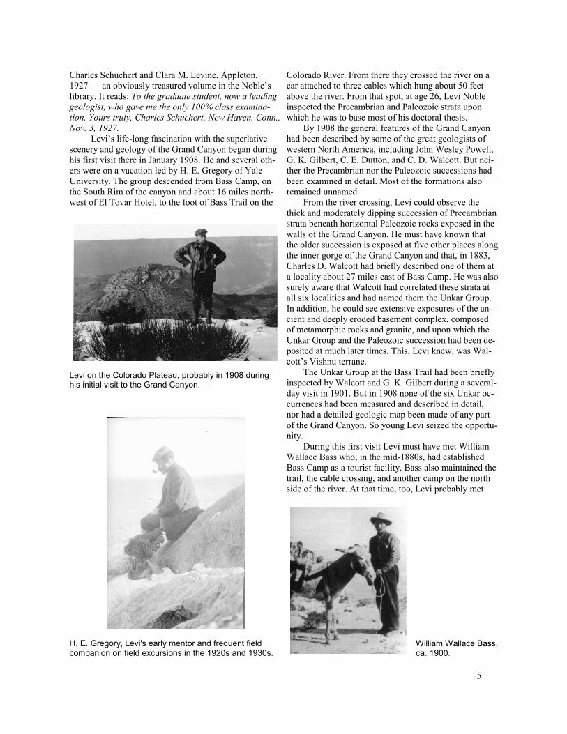
Levi’s life-long fascination with the superlative scenery and geology of the Grand Canyon began during his first visit there in January 1908. He and several others were on a vacation led by H. E. Gregory of Yale University. The group descended from Bass Camp, on the South Rim of the canyon and about 16 miles north-west of El Tovar Hotel, to the foot of Bass Trail on the
Levi on the Colorado Plateau, probably in 1908 during his initial visit to the Grand Canyon.
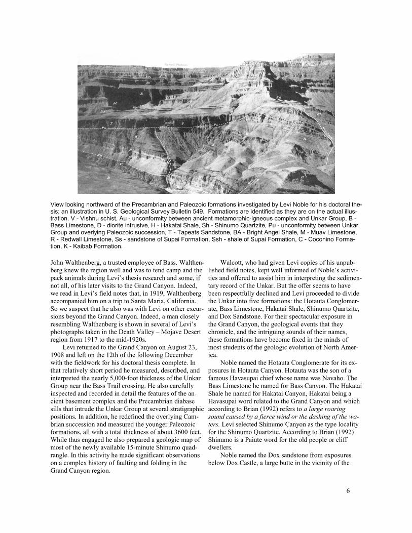
H. E. Gregory, Levi's early mentor and frequent field companion on field excursions in the 1920s and 1930s.
Colorado River. From there they crossed the river on a car attached to three cables which hung about 50 feet above the river. From that spot, at age 26, Levi Noble inspected the Precambrian and Paleozoic strata upon which he was to base most of his doctoral thesis.
By 1908 the general features of the Grand Canyon had been described by some of the great geologists of western North America, including John Wesley Powell, G. K. Gilbert, C. E. Dutton, and C. D. Walcott. But neither the Precambrian nor the Paleozoic successions had been examined in detail. Most of the formations also remained unnamed.
From the river crossing, Levi could observe the thick and moderately dipping succession of Precambrian strata beneath horizontal Paleozoic rocks exposed in the walls of the Grand Canyon. He must have known that the older succession is exposed at five other places along the inner gorge of the Grand Canyon and that, in 1883, Charles D. Walcott had briefly described one of them at a locality about 27 miles east of Bass Camp. He was also surely aware that Walcott had correlated these strata at all six localities and had named them the Unkar Group. In addition, he could see extensive exposures of the ancient and deeply eroded basement complex, composed of metamorphic rocks and granite, and upon which the Unkar Group and the Paleozoic succession had been de-posited at much later times. This, Levi knew, was Walcott’s Vishnu terrane.
The Unkar Group at the Bass Trail had been briefly inspected by Walcott and G. K. Gilbert during a several-day visit in 1901. But in 1908 none of the six Unkar occurrences had been measured and described in detail, nor had a detailed geologic map been made of any part of the Grand Canyon. So young Levi seized the opportunity.
During this first visit Levi must have met William Wallace Bass who, in the mid-1880s, had established Bass Camp as a tourist facility. Bass also maintained the trail, the cable crossing, and another camp on the north side of the river. At that time, too, Levi probably met
William Wallace Bass, ca. 1900.
5
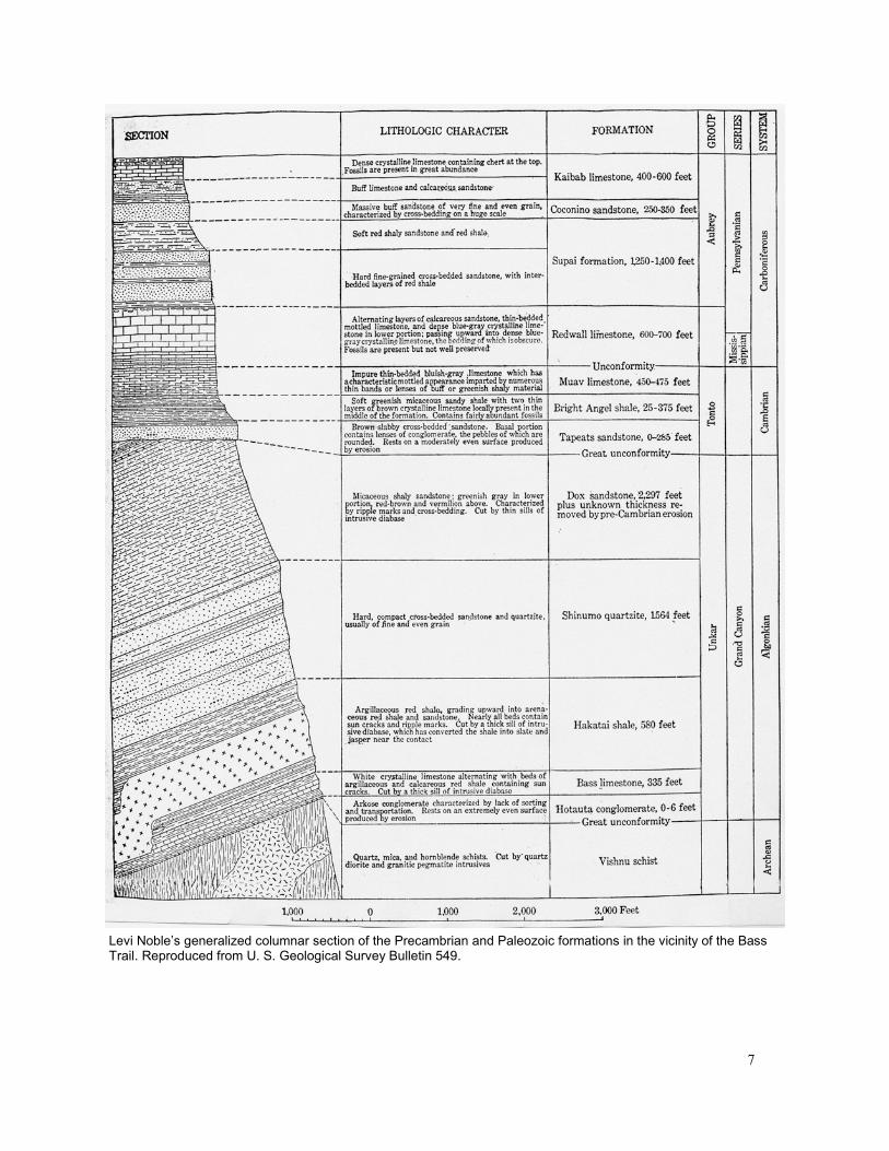
View looking northward of the Precambrian and Paleozoic formations investigated by Levi Noble for his doctoral thesis; an illustration in U. S. Geological Survey Bulletin 549. Formations are identified as they are on the actual illustration. V - Vishnu schist, Au - unconformity between ancient metamorphic-igneous complex and Unkar Group, B -Bass Limestone, D - diorite intrusive, H - Hakatai Shale, Sh - Shinumo Quartzite, Pu - unconformity between Unkar Group and overlying Paleozoic succession, T - Tapeats Sandstone, BA - Bright Angel Shale, M - Muav Limestone, R - Redwall Limestone, Ss - sandstone of Supai Formation, Ssh - shale of Supai Formation, C - Coconino Formation, K - Kaibab Formation.
John Walthenberg, a trusted employee of Bass. Walthenberg knew the region well and was to tend camp and the pack animals during Levi’s thesis research and some, if not all, of his later visits to the Grand Canyon. Indeed, we read in Levi’s field notes that, in 1919, Walthenberg accompanied him on a trip to Santa Maria, California. So we suspect that he also was with Levi on other excursions beyond the Grand Canyon. Indeed, a man closely resembling Walthenberg is shown in several of Levi’s photographs taken in the Death Valley – Mojave Desert region from 1917 to the mid-1920s.
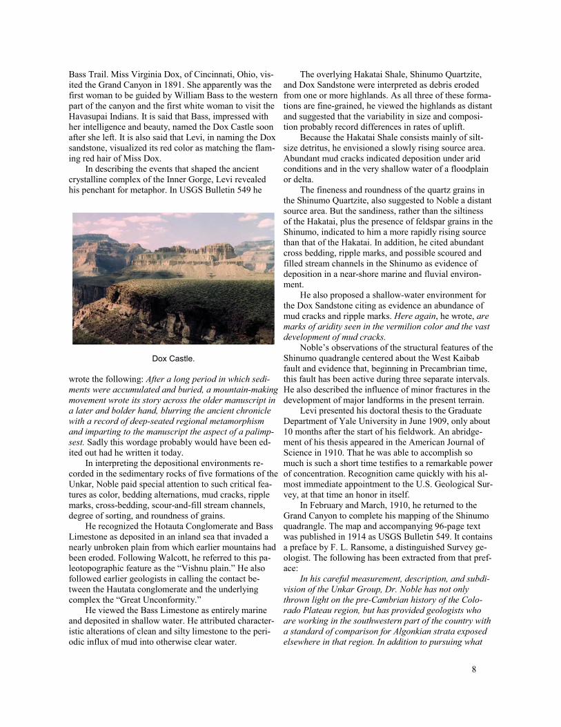
Levi returned to the Grand Canyon on August 23, 1908 and left on the 12th of the following December with the fieldwork for his doctoral thesis complete. In that relatively short period he measured, described, and interpreted the nearly 5,000-foot thickness of the Unkar Group near the Bass Trail crossing. He also carefully inspected and recorded in detail the features of the ancient basement complex and the Precambrian diabase sills that intrude the Unkar Group at several stratigraphic positions. In addition, he redefined the overlying Cambrian succession and measured the younger Paleozoic formations, all with a total thickness of about 3600 feet. While thus engaged he also prepared a geologic map of most of the newly available 15-minute Shinumo quadrangle. In this activity he made significant observations on a complex history of faulting and folding in the Grand Canyon region.
Walcott, who had given Levi copies of his unpublished field notes, kept well informed of Noble’s activities and offered to assist him in interpreting the sedimentary record of the Unkar. But the offer seems to have been respectfully declined and Levi proceeded to divide the Unkar into five formations: the Hotauta Conglomerate, Bass Limestone, Hakatai Shale, Shinumo Quartzite, and Dox Sandstone. For their spectacular exposure in the Grand Canyon, the geological events that they chronicle, and the intriguing sounds of their names, these formations have become fixed in the minds of most students of the geologic evolution of North America.
Noble named the Hotauta Conglomerate for its exposures in Hotauta Canyon. Hotauta was the son of a famous Havasupai chief whose name was Navaho. The Bass Limestone he named for Bass Canyon. The Hakatai Shale he named for Hakatai Canyon, Hakatai being a Havasupai word related to the Grand Canyon and which according to Brian (1992) refers to a large roaring sound caused by a fierce wind or the dashing of the wa-ters. Levi selected Shinumo Canyon as the type locality for the Shinumo Quartzite. According to Brian (1992) Shinumo is a Paiute word for the old people or cliff dwellers.
Noble named the Dox sandstone from exposures below Dox Castle, a large butte in the vicinity of the
6
Levi Noble’s generalized columnar section of the Precambrian and Paleozoic formations in the vicinity of the Bass Trail. Reproduced from U. S. Geological Survey Bulletin 549.
7
Bass Trail. Miss Virginia Dox, of Cincinnati, Ohio, visited the Grand Canyon in 1891. She apparently was the first woman to be guided by William Bass to the western part of the canyon and the first white woman to visit the Havasupai Indians. It is said that Bass, impressed with her intelligence and beauty, named the Dox Castle soon after she left. It is also said that Levi, in naming the Dox sandstone, visualized its red color as matching the flaming red hair of Miss Dox.
In describing the events that shaped the ancient crystalline complex of the Inner Gorge, Levi revealed his penchant for metaphor. In USGS Bulletin 549 he
Dox Castle.
wrote the following: After a long period in which sedi-ments were accumulated and buried, a mountain-making movement wrote its story across the older manuscript in a later and bolder hand, blurring the ancient chronicle with a record of deep-seated regional metamorphism and imparting to the manuscript the aspect of a palimp-sest. Sadly this wordage probably would have been edited out had he written it today.
In interpreting the depositional environments re-corded in the sedimentary rocks of five formations of the Unkar, Noble paid special attention to such critical features as color, bedding alternations, mud cracks, ripple marks, cross-bedding, scour-and-fill stream channels, degree of sorting, and roundness of grains.
He recognized the Hotauta Conglomerate and Bass Limestone as deposited in an inland sea that invaded a nearly unbroken plain from which earlier mountains had been eroded. Following Walcott, he referred to this paleotopographic feature as the “Vishnu plain.” He also followed earlier geologists in calling the contact be-tween the Hautata conglomerate and the underlying complex the “Great Unconformity.”
He viewed the Bass Limestone as entirely marine and deposited in shallow water. He attributed characteristic alterations of clean and silty limestone to the periodic influx of mud into otherwise clear water.
The overlying Hakatai Shale, Shinumo Quartzite, and Dox Sandstone were interpreted as debris eroded from one or more highlands. As all three of these formations are fine-grained, he viewed the highlands as distant and suggested that the variability in size and composition probably record differences in rates of uplift.
Because the Hakatai Shale consists mainly of silt-size detritus, he envisioned a slowly rising source area. Abundant mud cracks indicated deposition under arid conditions and in the very shallow water of a floodplain or delta.
The fineness and roundness of the quartz grains in the Shinumo Quartzite, also suggested to Noble a distant source area. But the sandiness, rather than the siltiness of the Hakatai, plus the presence of feldspar grains in the Shinumo, indicated to him a more rapidly rising source than that of the Hakatai. In addition, he cited abundant cross bedding, ripple marks, and possible scoured and filled stream channels in the Shinumo as evidence of deposition in a near-shore marine and fluvial environment.
He also proposed a shallow-water environment for the Dox Sandstone citing as evidence an abundance of mud cracks and ripple marks. Here again, he wrote, are marks of aridity seen in the vermilion color and the vast development of mud cracks.
Noble’s observations of the structural features of the Shinumo quadrangle centered about the West Kaibab fault and evidence that, beginning in Precambrian time, this fault has been active during three separate intervals. He also described the influence of minor fractures in the development of major landforms in the present terrain.
Levi presented his doctoral thesis to the Graduate Department of Yale University in June 1909, only about 10 months after the start of his fieldwork. An abridgement of his thesis appeared in the American Journal of Science in 1910. That he was able to accomplish so much is such a short time testifies to a remarkable power of concentration. Recognition came quickly with his almost immediate appointment to the U.S. Geological Survey, at that time an honor in itself.
In February and March, 1910, he returned to the Grand Canyon to complete his mapping of the Shinumo quadrangle. The map and accompanying 96-page text was published in 1914 as USGS Bulletin 549. It contains a preface by F. L. Ransome, a distinguished Survey geologist. The following has been extracted from that preface:
In his careful measurement, description, and subdi-vision of the Unkar Group, Dr. Noble has not only thrown light on the pre-Cambrian history of the Colo-rado Plateau region, but has provided geologists who are working in the southwestern part of the country with a standard of comparison for Algonkian strata exposed elsewhere in that region. In addition to pursuing what
8

may be considered the main purpose of the investiga-tion, Dr. Noble has added much to our knowledge of the general geology and erosional history of the Shinumo quadrangle — that is, of the western part of the Kaibab division of the Grand Canyon — and the map which ac-companies this bulletin represents the first geologic mapping done in the canyon that attains the accuracy and detail set for the Geologic Atlas of the United States. By describing examples additional to those previ-ously known he has shown the prevalence and structural importance of pre-Cambrian faults and the recurrence of movement in post-Paleozoic time along these ancient fractures. He also has called attention to the influence of minor joints and of fractures not associated with notice-able displacement in guiding the forces of erosion and in determining topographic form.
Although the bulletin contains considerable lithologic and stratigraphic material that will scarcely interest those who are not geologists, Dr. Noble has very properly remembered that the people as a whole have unusual claims to consideration in any publication deal-ing with the Grand Canyon, and has skillfully supplied as a setting to his more strictly scientific work much vivid description and lucid explanation which will help all those who take more than a transient and superficial interest in what they see to understand one of the im-pressive and significant of the inanimate works of na-ture.
Noble’s Later Investigations of the Paleozoic Formations of the Grand Canyon
Levi returned to the Grand Canyon in 1914, 1916, and 1920 to continue his investigations of the Paleozoic formations. Although these formations had been de-scribed in a general way by earlier workers, including Walcott in 1890, Dutton in 1910, and Noble himself in 1914, none of the earlier descriptions met his standards for the kind of accuracy which would be, in his words, adequate as a standard for close and accurate compari-son and correlation of the formations from place to place in the canyon or for a detailed comparison for Paleozoic rocks exposed elsewhere in Arizona.
Noble was concerned primarily with a foot-by-foot measurement of the entire Paleozoic section where ex-posed along the Bass Trail. He presented his detailed formal description of this section in ten pages at the be-ginning of U.S. Geological Survey Professional Paper 131-B and then devoted most of the remaining 37 pages of the text to an elaboration of this description including the character of the strata, their subdivisions, fossil con-tent, and the unconformities. He also provided a graphic portrayal of the stratigraphy of the Bass Trail section as a plate in this publication. In these presentations he was
careful to acknowledge the work of his predecessors, particularly the assistance and data given him by Walcott.
Noble’s special interest in the Cambrian and Devonian formations continued and led him to document their lateral variability within the Grand Canyon and to map their exposures beyond his published geologic map of the Shinumo quadrangle into the Bright Angel and Vishnu quadrangles. He accomplished these objectives in March and April of 1914 at age 32. Accompanied by John Walthenberg as packer and guide, he followed the part of the Tonto Trail that connects Garnet Canyon on the west with Red Canyon on the east. This trail is con-fined to the Tonto Platform which lies above the vertical cliffs of the Tapeats Sandstone and is cut in the less resistant strata of the overlying Bright Angel Shale. Garnet and Red Canyon are about 30 miles apart, but the connecting segment of the trail, which winds in and out of the side canyons, is about 100 miles long.
Noble and Walthenberg camped for more than one night at each of 16 localities along the Tonto Trail. At six of them, including the crossing of the Bass Trail, Noble measured detailed columnar sections of the Cambrian and Devonian strata. The six sections were presented on a plate, also in Professional Paper 131-B, on which lateral changes in thickness and lithology are faithfully shown. On this plate he also connected his sections with the more generalized columnar section measured by Walcott at the head of Nankoweap Valley, about 15 miles north of Red Canyon. Walcott had published this section in 1890 in the Tenth Annual Report of the U.S. Geological Survey.
Stratigraphic columnar section of the Cambrian and Devonian formations of the Grand Canyon as exposed near the Bass Trail and measured by Levi on visits from 1914 to 1920; an illustration in U.S. Geological Survey Professional Paper 131-B.
9
Levi’s detailed stratigraphic descriptions and interpretations are recognized today as the first application of modern stratigraphic techniques to the formations ex-posed in the Grand Canyon. They have continued to be useful to later workers.
Edwin D. McKee, a distinguished geologist and career investigator of the stratigraphy of the Grand Canyon wrote Noble in 1941 saying I have looked forward with pleasure to meeting you for a good many years… I have always treated your papers on the Grand Canyon as a sort of Bible and use them very often. McKee, and C. D. Resser, in a paper published in 1945, observe that Noble’s work was so complete that it has made unneces-sary the spending of much time in reexamining sections during the present investigation and his methods have served as a model in recent studies of sedimentary stratigraphy.
From his early publications it is also obvious that Levi, as a young man, had acquired an emotional attachment for, as well as a scientific interest in, the landscapes and rock formations that lay before him. At age 29, recalling his initial viewing of the Grand Canyon, he described this experience as casting a spell from which the observer is never entirely free.
The First Close Examination of the Rock Units of the Inner Gorge
While crossing side canyons along the Tonto Trail, Noble observed that a number of them provided access to the Inner Gorge (also known as the Granite Gorge) of the Grand Canyon and thus to the ancient complex of metamorphic and igneous rocks that underlie the Unkar Group. In 1914 very little was known of the nature and distribution on the rock units that comprise the complex which at that time was vaguely assigned an Archean age. An investigation of them had not been included in the planning of the traverse. Nor was there time to engage in a thorough investigation of them during this traverse. But Noble characteristically seized the opportunity to do what could be done and descended to the Colorado River along eight of the tributaries. There he collected 67 representative samples of the complex from 20 localities.
Following the completion of the traverse along the Tonto Trail, Levi shipped his specimens to USGS laboratories in Washington D.C. and arranged for petrologist Fred Hunter to inspect thin sections of them. Noble and Hunter published their observations in 1916 as USGS Professional Paper 98-I. It contains Hunter’s detailed descriptions, Noble’s division of the rocks into eight groups according to predominant rock type, and Noble’s observations of the distribution of each within the gorge.
In the wordage of this paper we find further evidence of Noble’s expressiveness. He describes the Tapeats cliff as wonderfully persistent and as the chief obstacle that bars the way to the Archean rocks. He also observes that descending into it (the Granite Gorge) the traveler leaves the wide outer canyon, whose walls are carved in horizontal Paleozoic strata and enters into what is geologically and scenically another world…The change in scenery is no less abrupt than the change in geologic structure. The sides of the Granite Gorge, carved in Archean rocks, descend to the river in steep, bare slopes whose surface is jagged and chaotic in the extreme.
The Marriage
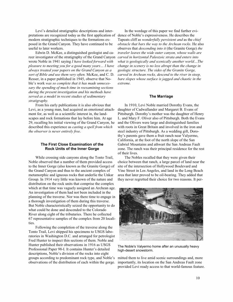
In 1910, Levi Noble married Dorothy Evans, the daughter of Cadwallander and Margaret B. Evans of Pittsburgh. Dorothy’s mother was the daughter of Henry L. and Mary F. Oliver also of Pittsburgh. Both the Evans and the Olivers were large and distinguished families with roots in Great Britain and involved in the iron and steel industry of Pittsburgh. As a wedding gift, Dorothy’s parents gave them a fruit ranch near Valyermo, California, at the foot of the north slope of the San Gabriel Mountains and athwart the San Andreas Fault zone. The ranch was their principal residence for the rest of their lives.
The Nobles recalled that they were given their choice between that ranch, a large parcel of land near the site of the intersection of Hollywood Boulevard and Vine Street in Los Angeles, and land in the Long Beach area that later proved to be oil-bearing. They added that they never regretted their choice for two reasons. It per-
The Noble's Valyermo home after an unusually heavy high-desert snowstorm.
mitted them to live amid scenic surroundings and, more importantly, its location on the San Andreas Fault zone provided Levi ready access to that world-famous feature.
10

A B
C D
E F
G H I
About four years after their marriage in 1910, the Nobles visited Levi's thesis area and camped in the Inner Gorge of the Grand Canyon. Accompanied by John Walthenberg and several mules, they enjoyed the best of camping equipment and much food. From these photos one can sense Levi's serenity and Dorothy's aplomb in a carefully organized shared experience. A. Dorothy and John Walthenberg fetching the mules. B. William Bass and John Walthenberg loading the mules. C. Dorothy, apparently in rain gear riding toward the rim. D. Dorothy and John Walthenberg eating lunch en route. E. Pack train negotiating the cliffs. F. Reassembling on the north side of the Colorado River. G. Dorothy at ease in camp. H. Levi in relaxing gear and inspecting a flower in the presence of Walthenberg. I. Levi at ease in field clothes.
11

Although the Nobles were favored with an independent income, derived from both of their families and much more than adequate to their basic needs, they chose to live modestly and privately. Their six-room frame home, for example, lay nearly hidden among the trees of the ranch and was accessible only by a narrow dirt road. A small building, a few hundred yards from the ranch house, served as Levi’s study. He delighted in showing visitors that it was built on the ground rupture produced by the great Fort Tejon earthquake of 1857. One sensed that he secretly wished to ride out another dislocation along the same rupture.
In keeping with their chosen lifestyle, they also elected to operate the ranch at a profit. So during harvest season they increased the income from the ranch by maintaining a fruit stand on the highway through Valyermo. Dorothy was commonly its sole attendant. Also “to make ends meet” Dorothy served as the Valyermo postmaster from 1914 to 1930. Indeed, a person unfamiliar with their secure financial status, and listening to their everyday concerns, could easily assume that they depended solely on these modest resources.
Fruit stand at the Valyermo Ranch. Dorothy, its sole attendant, stands in the entranceway.
There were clear signs of elegance, however, in their surroundings and annual activities. We observed as evidence their summertime retreat to Levi’s ancestral Victorian home in Auburn. There they would temporarily live in the genteel style long characteristic of wealthy residents of upstate New York. In their later years, they owned two Jaguars, a sedan in Valyermo and a sports car stored in Auburn for their summer use. During their brief and occasional visits to Los Angeles they would stay in the finest hotels and order meals through room service.
Their wardrobes, although generally understated, consisted mainly of items made to their own specifications by Brooks Brothers, New York. Even Levi’s field clothes were made to order. One of his favorites was a
The Jaguar.
yellow shirt with red polka dots. He also loved to dress in the manner of Sherlock Holmes, his favorite fictional detective. In his fieldwork, he sometimes donned that long cape and a double-billed cap, justifiably claiming that they offered him warmth, freedom of movement and protection from the sun.
Levi in his Sherlock Holmes attire.
The Nobles did not attend church regularly. This was true at least during their wintertime months in Valyermo without a nearby Episcopalian edifice. But a well-worn Book of Common Prayer lay always at their Valyermo bedside. We also learned that, at age 17, Levi received a gift of the New Testament, in the original Greek, which he apparently cherished. They also possessed an Evans Bible with a complete family register dating from 1843.
His Professional Life
Given the freedom of an independent income, for most of his career, Levi Noble was able to assume nearly full control of his day-to-day activities as well as his long-term professional objectives. Although officially a member of the United States Geological Survey, almost from the day that he received his doctorate, he
12
was, within broad limits, permitted to select his own projects and to pursue them at his own pace. For this privilege he insisted that he receive only a token salary.
Levi obviously felt that he was more than repaid through the professional freedom that he enjoyed and also through his close association with a group of distinguished Survey colleagues, including “Mendy” (W. C. Mendenhall), “Chester” (C. R. Longwell), “Tom” (T. B. Nolan), “Jim” (James Gilluly), and “Bill” (W. H. Brad-ley). But foremost among them, in Levi’s estimation, was Henry G. Ferguson, who pioneered much of the geology of the central Great Basin. He was Noble’s life-time friend and confidant. To Levi, and to numerous others, he was simply “Fergy.” Levi affectionately referred to a younger group of Survey geologists as “the boys.” These included Charles B. Hunt, Charles A. Anderson, and Charles S. Denny. Levi and Dorothy also were visited many times by his friend and early mentor H. E. Gregory.
enjoyed by wealthy families in the northern Atlantic states to the ownership of the fruit ranch in the high desert of southern California. Early in this period they adjusted to life in a modest six-room home. Apparently by mutual agreement, Dorothy became the manager of the ranch, overseeing the ranch hands in their various duties and directing the business side of this new undertaking. Then, too, in their new surroundings, they began to be regularly visited by relatives and friends from their earlier years and by Dorothy’s nephew who owned the ad-joining ranch. At that time they also must have resolved to maintain the Noble family mansion in Auburn and to spend their summer months there.
Levi, as a professional geologist, had unfulfilled commitments to his Grand Canyon program. The map-ping of the Shinumo quadrangle remained incomplete, as did his investigation of the Paleozoic formations ex-
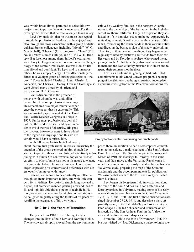
Levi’s discomfort in the presence of persons with whom he was unfamiliar caused him to avoid professional meetings. He remembered as a major traumatic experience the one paper that he gave orally. This was an invited paper presented at the Third Pan-Pacific Science Congress in Tokyo in 1927. Unlike most professionals, Levi did not feel the need to be seen and heard in order to avoid the risk of obscurity. His genuine shyness, however, seems to have added to the legend and mystique and this we are certain would have surprised him. Dorothy Noble, center, overseeing her ranch hands.
With fellow geologists he talked mostly about their mutual professional interests. Invariably the posed there. In addition he had a self-imposed commit-attention of the group centered on him, though Levi ment to investigate a major segment of the San Andreas seemed to prefer otherwise and listened attentively in his Fault. His return to the Grand Canyon in February and dialog with others. On controversial topics he listened carefully to others, but it was not in his nature to engage in arguments. Indeed, he seemed incapable of feeling anger, expressing his concerns and differences with others openly, but never with rancor.
Instead Levi seemed to be constantly in reflective thought on items important to him, and with little concern for trivialities. He spoke in simple language and in a quiet, but animated manner, pausing now and then to fill and light his ubiquitous pipe or to rekindle it. Humor, however, came naturally into his conversations as he delighted in gently citing the foibles of his peers or recalling the escapades of his own youth.
1910-1917, the Years of Transition
The years from 1910 to 1917 brought major changes into the lives of both Levi and Dorothy Noble. The newlyweds abruptly moved from the environments
March of 1910, his marriage to Dorothy in the same year, and their move to the Valyermo Ranch came in rapid succession. We can easily visualize him in his new Valyermo study, preparing the map of the Shinumo quadrangle and the accompanying text for publication. We assume that much of the text was simply extracted from his thesis.
Levi began his long-term field investigation along the trace of the San Andreas Fault soon after he and Dorothy arrived in Valyermo, making some of his early observations between his visits to the Grand Canyon in 1914, 1916, and 1920. The first of these observations are dated November 27-28, 1914, and describe a visit, apparently alone, to the Palmdale-Tejon Pass area. A year later, at age 33, he led Schuchert and Ransome on an inspection of the San Andreas Fault in the Valyermo area and the formations it displaces there.
From the 12th to the 25th of November, 1916, Noble was visited by N.A. Dickensen, a paleontologist spe-
13
cializing in the Eocene formations of California. He was there apparently at Noble’s invitation. The notations and sketches are mostly Dickensen’s and refer to the nature and distribution of Cenozoic sedimentary formations along the fault-bounded north side of the San Gabriel Mountains. Obviously Noble knew of the key localities beforehand and assumed that their observations would be helpful in his attempts to reconstruct displacements along the San Andreas Fault. Dickensen returned for two other visits, one for 6 days in March and April, 1917, and the other in July and August of the same year.
The Nitrate Program, Noble's Introduction to Death Valley
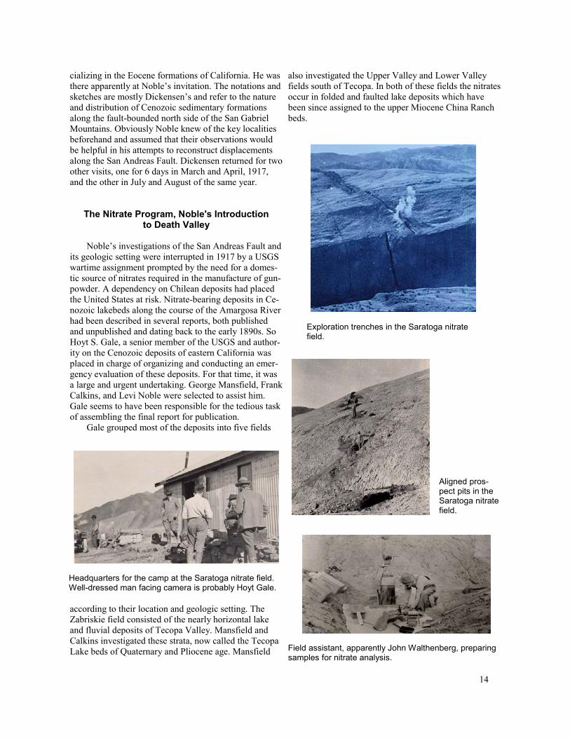
Noble’s investigations of the San Andreas Fault and its geologic setting were interrupted in 1917 by a USGS wartime assignment prompted by the need for a domes-tic source of nitrates required in the manufacture of gun-powder. A dependency on Chilean deposits had placed the United States at risk. Nitrate-bearing deposits in Cenozoic lakebeds along the course of the Amargosa River had been described in several reports, both published and unpublished and dating back to the early 1890s. So Hoyt S. Gale, a senior member of the USGS and authority on the Cenozoic deposits of eastern California was placed in charge of organizing and conducting an emergency evaluation of these deposits. For that time, it was a large and urgent undertaking. George Mansfield, Frank Calkins, and Levi Noble were selected to assist him. Gale seems to have been responsible for the tedious task of assembling the final report for publication.
Gale grouped most of the deposits into five fields
Headquarters for the camp at the Saratoga nitrate field. Well-dressed man facing camera is probably Hoyt Gale.
according to their location and geologic setting. The Zabriskie field consisted of the nearly horizontal lake and fluvial deposits of Tecopa Valley. Mansfield and Calkins investigated these strata, now called the Tecopa Lake beds of Quaternary and Pliocene age. Mansfield
also investigated the Upper Valley and Lower Valley fields south of Tecopa. In both of these fields the nitrates occur in folded and faulted lake deposits which have been since assigned to the upper Miocene China Ranch beds.
Exploration trenches in the Saratoga nitrate field.
Aligned prospect pits in the Saratoga nitrate field.
Field assistant, apparently John Walthenberg, preparing samples for nitrate analysis.
14

The nitrate-bearing lake beds of the Saratoga and Confidence fields form parts of two elongate clusters of hills distributed, nearly end-to-end, along the length of southern Death Valley. The beds are Pliocene and Pleistocene. Each occurrence is involved in the Southern Death Valley fault zone and is thus folded and faulted, in contrast with the nearly horizontal Tecopa Lake beds of essentially the same age. Calkins headed the exploration of the Confidence field. Noble’s responsibility was for the Saratoga field. Interestingly, after Levi’s death— and unaware that the hills that contain the Saratoga field are where he began his geological investigations in the Death Valley region—we have referred to them as the Noble Hills. The name is now commonly used.
Crews of miners, analysts, and geologists operating out of hastily constructed camps explored the nitrate de-posits in each of the fields. Thousands of samples were collected, at first from long trenches, later from prospect pits. As the project proceeded, the nitrate was shown to be persistently concentrated within a foot of the surface in a deposit known as caliche. The tonnage at any one locality was thus much too small to be profitably mined.
Apparently excluded from the initial exploration plan were nitrate-bearing lake beds on claims in the vicinity of Shoshone owned by a Mr. Ratliff and associates. Noble evaluated these claims from October 13 to 25, 1918, we assume under instruction from Gale. In the files in our possession this is the first record of Levi’s presence in Shoshone which was to be his Death Valley field headquarters for the rest of his life. Photographs in the Noble’s collection show a makeshift lodging composed of a canvas cover in a decaying adobe dwelling.
Crumbling adobe house in the vicinity of Shoshone. Levi and Dorothy apparently camped here from October 13 to 25, 1918, during his inspection of nearby nitrate claims. This may have been their first visit to Shoshone. Photo is dated October 22, 1918. These walls were incorporated in a later structure and still stand.
Levi’s report was submitted on November 4. Four months later Noble received a letter from Gale, dated
March 7, 1919. It reads in part, Dear Noble: I am send-ing at this rather late date the carbon copy of the Amar-gosa nitrate report… Now I realize that I have not time to go over this carefully enough, and as you should see and have a chance to revise it before it goes to the edi-tor, I am forwarding this copy to you with the request that you make occasion to put it into shape as soon as you can… I suggest that where necessary you simply abstract a page, making your own new copy with same numbering and substitute it for the abstracted page… I am sorry that I did not take a larger part in the work that I had some part in for so long , but I seemed to have my hands full elsewhere…Yours with warm regard, Hoyt S. Gale.
This was probably the last direct order that Levi Noble, now 37 years old, received from a Survey superior. We can only guess at his immediate reaction. We do know that he responded dutifully and that the report was published in 1922 as USGS Bulletin 724, authored by L. F. Noble, G. R. Mansfield and others. The parts written by Levi flow in his characteristic style and clearly convey an early attachment to the Death Valley terrain. For example he observes that A few conspicuous features mark the South Death Valley and Amargosa region in an unusual way. Perhaps the most striking is the utter bar-renness of the rock mountain walls and the distinctness with which the dull reds, browns, and other characteris-tic colors of these rocks show even at great distances in the clear air. The gorge of Amargosa River below Te-copa is one of the weird features of this desolate region, being carved in fantastic forms through peculiarly var-ied volcanic flow rocks, conglomeratic breccias, and the so-called lakebed sediments.
In another place he describes the Black Mountains as follows: The most precipitous slopes in the region are those of the Black Mountains, along the northeast mar-gin of the valley northeast of Confidence. Here in places the mountains rise more than 5000 feet above the valley in a distance of 2 miles and are so intricately dissected that, when viewed from a distance in the late afternoon, the corrugations on their slopes resemble the wrinkles on a withered apple.
Further along he observes that The topographic fea-tures just described — steep slopes at most places along the valley margin, and gentler slopes in the higher por-tions of the bordering mountains — suggests that South Death Valley owes its origin to faulting. Apparently the Death Valley trough is a long, narrow block of the earth’s crust that has been depressed along one or more faults, but the structure is complex, because the moun-tains bordering the valley are themselves crustal blocks that have been elevated, tilted, and rotated in various directions, and the movements have not taken place in a single period of time.
15

The Noble’s Shoshone Connection and Their Enduring Friendships with
Members of the Fairbanks-Brown Family
During the nitrate program, probably in 1918 when Levi was examining the Ratliff claims, the Nobles began an attachment to the community of Shoshone and its in-habitants. At that time the Shoshone town site was owned by Borax Consolidated Ltd., which operated the Tonopah and Tidewater Railroad, and was being man-aged by Ralph J. “Dad” Fairbanks as a watering and boarding stop.
From the end of the nitrate program in 1918 until the beginning of his major Death Valley project in 1931, Shoshone provided accommodations for Levi and his associates on numerous excursions into the Death Valley region. In 1931 Shoshone became Levi’s Death Valley field headquarters and also the Noble’s third home. From then and into the late 1940s they rented a small cabin, made of railroad ties, which they called Whiffle-tree Hall. Also during much of that time the Nobles made Shoshone their official voting residence as they, being dedicated Republications, good-naturedly endeavored to offset the strongly Democratic majority of the other residents.
Levi resting outside of Wiffletree Hall, the Noble's Shoshone residence in the 1930s.
Voting day in Shoshone in the early 1940s. Celestia Brown, facing, and now of age, has just voted Democratic. Dorothy Noble, right, will counter as a Re-publican.
In Shoshone, the Nobles found lasting friends particularly in Charles and Stella Brown and their four children Bernice, Charles, George, and Celestia. Charles and Stella became permanent residents of Shoshone in 1920. Their earlier years were deeply rooted in the Death Val-ley region. Stella was the daughter of Ralph, J. “Dad” Fairbanks and his wife, Celestia. Charles had worked in the mines and served as Deputy Sheriff. In 1942, he acquired title to the land and buildings of Shoshone from the Pacific Coast Borax Company, and this property has remained in the Brown family since then.
Charlie and Stella Brown and their four children in the early 1930s. From left to right:: Celestia, George, Stella, Bernice, Charles Jr., and Charlie. The store building is now the Shoshone Museum.
During the 1930s, when Levi was most actively en-gaged in his Death Valley work, the Nobles strengthened their attachment to Shoshone and also their friend-ship with Charles “Charlie” and Stella Brown. Although very different in their backgrounds and lifestyles, the Nobles and Browns shared a fondness for the desert and desert living. During the 1930s and 1940s, Levi and Dorothy observed the four Brown children pass from childhood to adulthood.
Charlie served 16 years as an Inyo County Commissioner and 20 years as State Senator for Inyo, Mono, and Alpine Counties. During his tenure as Senator he be-came one of the most influential men in the California Legislature. In the later years he chaired both the Senate Finance Committee and the Ways and Means Commit-tee. It was said that any legislative bill that wasn’t in Charlie’s shirt pocket had no chance.
Charlie Brown was a big man, broad, and 6' 4" tall. So he and the much smaller Levi were an arresting sight when they walked together in Shoshone, perhaps heading for the Crowbar where they would good-humoredly insult each other and recall past events and experiences.
16

View looking southeastward from the area of the Valyermo Ranch, showing trace of San Andreas Fault. Sketch by P. B. King, a distinguished member of the U.S. Geological Survey, accompanies Noble's geologic map of the Valyermo Quadrangle.
But Charlie clearly knew almost nothing of Levi’s life as a geologist and Levi could never really relate to Char-lie’s political life.
Mapping and Interpreting the San Andreas Fault in the 1920s
During the early 1920s, with his obligations to the nitrate program complete, Levi Noble continued his field investigations of the San Andreas Fault zone and worked toward the publication of a reconnaissance map of a 50-mile segment extending from the vicinity of Soledad Pass on the west to Cajon Pass on the east. Although this map was not published until 1954, he presented summaries of his findings and interpretations in several earlier reports.
The first of these was published in 1927 as part of the Carnegie Institute of Washington Yearbook No. 25. It contains the first printed statement that the San Andreas Fault may have displaced the crust laterally for many miles and is thus a landmark paper. In it Noble observes, Scarcely anywhere in the fault zone are the rocks on the opposite sides of the master fault similar. This relation is particularly marked in the pre-Tertiary rocks. For example, in a stretch 50 miles long extending from a point 6 miles southeast of Rock Creek to the Crafton Hills east of Redlands the fault is bordered con-tinuously on the south by the series of pre-Cambrian schists already described, whereas the rocks north of the fault are Mesozoic granites and pre-Cambrian gneisses. These relations show...that the movements along the fault have been of very great magnitude. Later in this paper Noble states that, The distribution of certain Terti-ary rock masses along the master fault affords a sugges-tion that a horizontal shift of many miles has taken place along the rift. He then proceeds to describe these features but adds, with typical modesty and caution that, the evidence just cited, however, is not convincing, and is
certainly not definite enough to amount to proof. Although his evidence concerning the offset of Tertiary formations did later prove questionable, his prescience in sensing very large horizontal displacement has been repeatedly demonstrated by other geologists observing other features along the full 700-mile length of the San Andreas Fault.
Other Activities from 1917 to 1930
Levi’s geologic activities in this interval extended well beyond the San Andreas Fault and the bordering San Gabriel Mountains. From 1921 to 1924, he visited
The Model T Ford touring car used by Levi during the nitrate project and on most or all of his geologic excursions in the 1920s. The man in the photo appears to be John Walthenberg.
and described a number of borate deposits in southern California and southern Nevada. Included among them was a newly discovered deposit, now known as the Gerstley deposit, near Shoshone. His was also the first description of the much larger borate deposit near Kramer in western San Bernardino County.
From his field notebooks of that period, we observe that Levi made numerous excursions, with widely rang-
17
ing objectives, into the southwestern part of the Great Basin, the Mojave Desert and the Colorado Plateau. On most of these excursions he was accompanied by one or more distinguished geologists among whom were W. M. Davis, H. G. Ferguson, H. S. Gale, H. E. Gregory, C. R. Longwell, G. R. Mansfield, and W. C. Mendenhall. His friend and mentor H. E. Gregory, however, was his most frequent companion. On most of these excursions and with characteristic thoroughness Levi logged the exact mileage between major points of interest. He also commonly listed the purchases of gasoline and the exact cost of his meals.
Recorded in the notebooks are descriptions and interpretations of features which Noble did not include in his publications and which a number of us later workers believed we were observing and interpreting for the first time. These early notations await a transcriber and a means of distribution to geologic historians. Also, as we read these notebooks, we could easily visualize how Levi was mentally registering major features in the Death Valley terrain in preparation for his later, more intensive investigation of the Death Valley region.
We have extracted from the notebooks the following brief accounts of the trips that seemed to be of special importance to Levi Noble.
September 15-18, 1919 Noble and Gregory drove in Noble’s Ford field auto to St. Thomas, Nevada, on the Virgin River. On some of this trip they apparently were accompanied by Chester Longwell who was then preparing a geologic map of much of south-central Nevada. Near St. Thomas, they inspected salt and gypsum deposits which they assumed to be Pliocene in age and de-scribed as resembling those in the Salt Basin adjacent to the Avawatz Mountains. In drawing upon their knowledge of the Paleozoic and Mesozoic formations of the Colorado Plateau, they made a number of widely ranging observations on the stratigraphy of the surrounding region.
May 1-11, 1921 Apparently as a USGS project, Noble and Hoyt Gale visited borate deposits at the southwest border of the Muddy Mountains, Clark County, Nevada. A brief description of their findings was published as USGS Bulletin 735-B. In it Noble praises Chester Longwell’s unpublished map of the Muddy Mountains. He also interprets the borates as de-posited by hot springs near the shore of a Tertiary lake. In the notebook Noble records that en route to Valyermo they also visited the borate deposits of the Furnace Creek area.
July and August, 1922 Noble and Gregory completed a geological traverse extending from Mojave, California, to the confluence of the Colorado and San Juan Rivers in southeastern Utah. Noble was then 40 years old and 14 years had passed since Gregory had introduced him to the Unkar Group at the foot of the
Bass Trail. His USGS Professional Paper 131-B on the Paleozoic rocks of the Grand Canyon was published or in press. Gregory had authored USGS Professional Pa-per 93, Geology of the Navaho Country, which had been published in 1917. This publication was devoted largely to the cover of Mesozoic sedimentary rocks exposed on the plateau into which the Grand Canyon has been eroded.
Apparently Noble was intent on learning more of the general geology of the southern part of the Great Basin and was also adding to his understanding of the stratigraphy of the Coconino Sandstone and Kaibab Limestone at the rim of the Grand Canyon. Gregory seemed to wish to supplement his knowledge of the Mesozoic cover rocks. They also must have wished to share their respective geologic findings.
In a brief paper published in the American Journal of Science they describe the western part of this journey as following the topographic trough Noble had described in the nitrate report and which extends from the southern part of Searles Lake basin eastward to the northern piedmont of the Avawatz Mountains and the southern end of Death Valley. They also recognized it as marking the eastward extension of the Garlock Fault which, 13 years earlier, had been identified and named by F. L. Hess from exposures to the west of Searles Lake basin. In noting the difference between the basin-and-range topography north of this fault and the region of shapeless de-pressions and irregular mountain ranges to the south, they suggested that the Leach Trough may be considered the natural northern boundary of Mojave Desert.
It is difficult to imagine them traveling through the Death Valley area in mid-summer, over primitive roads and in the vehicle shown on page 17 or one like it. On the other hand, it is easy to imagine Noble’s growing desire to map and interpret the geological features they were observing.
They also observed at the mouth of Rhodes Wash, in the eastern escarpment of Death Valley, beds of very coarse pre-Tertiary breccia, mostly quartzite. This may well be the first written mention of features that Noble was later to include in his “Amargosa chaos.”
In passing eastward, across the Amargosa and Pahrump Valleys to the Las Vegas Valley, they were impressed with how completely the sandstone-bearing formations of the Colorado Plateau are exposed on the east side of the Spring Mountains and thus well within the Basin and Range province. They were equally impressed with the absence of these formations west of the Spring Mountains. So they speculated that a mountainous area of non-deposition occupied the more westerly region in Mesozoic time.
They observed that the eastern boundary of the Basin and Range province in the region of the Virgin Mountains is marked by a great west-sloping alluvial fan
18

and attributed the absence of large alluvial fans on the Colorado Plateau to the fact that the Mesozoic formations of the Plateau characteristically weather to small particles that form neither talus nor gravels.
On their traverse of the Colorado Plateau, Noble and Gregory paid special attention to the younger of the Paleozoic formations exposed in the Grand Canyon and the older of the Mesozoic formations exposed on the Plateau. In so doing they both shared and extended their knowledge of the regional stratigraphy of these formations.
February 10-16, 1924 Noble and Gregory returned to Death Valley spending nights in Johannesburg, Ballarat, Hidden Spring, and Riggs. They visited the epsomite deposit west of Wingate Pass and noted the absence of shorelines at the elevation of the pass. They observed that the talc deposit in the Silurian Hills was “of replacement origin.”
August 31 to September 7, 1924 Noble, Longwell, and Hewett traversed the Spring Mountains on the first part of this trip and were impressed with the thickness of the Devonian, Mississippian, and Pennsylvanian strata and with the “great thrusts” exposed there. They later observed the Tertiary beds near Tecopa Pass (the China Ranch beds of later workers) and compared them with the Horse Spring beds of Longwell. They also observed the “great fault” (now called the Furnace Creek Fault) that separates Tertiary strata in Furnace Creek Wash from the bordering Paleozoic rocks of the Grapevine Mountains (now called the southern Funeral Mountains).
November 11-16, 1924 Noble, Mendenhall, and Hewett joined in an excursion from Valyermo to Sara-toga Spring, Goodsprings, the McCullough Range, Shoshone, Leach Lake, Granite Wells, and back to Valyermo. Their observations and discussions included the weathering of granite in an arid climate. In what clearly is another early reference to features that Noble was to later include in his Amargosa chaos, Noble states Far-ther up the wash, toward Bradbury Well, the rocks are a mess of crushed limestone (breccia), greenstone and gneiss. They observed various features of the Cambrian strata exposed near Jean, Nevada. Hewett described to them the very thick succession of Precambrian sedimentary rocks he had seen in the Kingston Range and also the pluton of quartz monzonite that intrudes it.
February 10-15, 1925 Noble and Gregory again returned to the Leach Trough via Barstow, Indian Spring, and Leach Point and thence on successive nights camped out at Mormon Point, Wingate Pass, and Panamint Valley. They sketched the manganese deposits at Owl Spring and observed their regional setting in the carbonate rocks and granite of the southern part of the Owlshead Mountains.
In the vicinity of Ashford Mill southeast of Mormon Point they made numerous widely ranging observations
of features in the bedrock of the Black Mountains front and in the flanking Cenozoic sedimentary and volcanic units. They were especially attracted by the apparently wave-cut benches in basalt on the feature now known as Shoreline Butte. They concluded that “this hill needs more study.”
March 18-25, 1925 Noble conducted William Morris Davis on a tour that included Owens Valley, Death Valley, and Panamint Valley. Davis was a distinguished geomorphologist who specialized in desert land-forms. They discussed and sketched various features ex-posed on and near of the escarpments that bound the Black Mountains and the Panamint Mountains on the west and described the escarpments as little eroded fault scarps. They sketched the wineglass canyons and other features that, indeed, identify the Black Mountains front as a gigantic fault scarp (see p. 20). During a traverse of central Death Valley, Noble also sketched the shorelines cut on Shoreline Hill and Mormon Point and drew what is probably the earliest representation of the Badwater “turtleback.” They also sketched the graben in the alluvial fan that issues from Wildrose Canyon on the west side of the Panamints.
November 21-28, 1925 Noble and Mansfield toured the industrial mineral deposits of the Mojave Desert-Death Valley region, Mansfield’s interest being primarily in this field. En route they visited the newly established chemical plant at Searles Lake, potash prospects bordering Fish Lake Valley, and the borate mine and a volcanic ash deposit near Shoshone.
October 8-13, 1930 Mendenhall and Ferguson accompanied Noble to Shoshone from where on successive days they visited Bennett’s Well, Badwater and Ashford Mill, returning to Valyermo via Walker Pass, Tehachapi and Mojave. Their recorded observations are concerned mainly with Cenozoic sedimentary and volcanic rocks in and around Shoshone, including the tilting of the Tecopa Lake beds.
Death Valley in Earnest
In October 1931, Levi, now 48, began his study of the general geology of the Death Valley region. In various ways this undertaking was more demanding than his investigations of the San Andreas Fault and his mapping of the Shinumo quadrangle of the Grand Canyon. His field headquarters in Shoshone were nearly 200 miles from Valyermo. In the early years, much of the road be-tween Valyermo and Shoshone was gravel. In addition, Levi had committed himself to investigating the geology of an area of about 8000 square miles covering parts of the Ballarat, Furnace Creek, Searles Lake, and Avawatz Mountains one-degree topographic maps. Moreover, in many ways, the geology of this region is more complex
19

Sketches drawn by Levi in March 1925 while viewing the Black Mountains front with William Morris Davis, a leading authority on the evolution of desert landforms. Noble was 43; Davis was 75. On March 21, they camped at Bennett's Well on the west side of Death Valley. From there and from other points in central Death Val-ley they discussed and sketched various topographic features that identify the western flank of the Black Mountains as a gigantic fault scarp. They also observed and sketched the benches that Noble had previously ascribed to the presence of a Pleistocene lake in Death Valley. Davis, 10 years beyond his retirement from Harvard University, apparently was rein-forcing Levi’s earlier observations and interpretations and also providing additional insights. In Levi’s field note-book are carefully written summaries of Davis' widely ranging comments on the evolution of arid landscapes. In 1930 Davis accepted a Distinguished Visiting Professorship at the California Institute of Technology which he held until his death in 1934. A secluded garden plot on the Caltech campus is maintained in his memory.
A. The wineglass canyons of the Black Mountains, the abrupt steepening at the base of the escarpment, and the horizontal bodies of conglomerate that cling to mountain front are recorded here probably for the first time. Davis has called to Noble's attention the open V valleys at the head of each of the major canyons and interprets them as existing on a subdued landscape before the formation of the scarp. They both seem puzzled by the absence of an alluvial fan at the mouth of the canyon on the far left and speculate that the canyon may be on a recently down-dropped block. The horizontal bodies of conglomerate have since been shown to be cemented by tufa deposited during a standstill of Pleistocene Lake Manly.
B. Here is probably the earliest portrayal of the Badwater turtleback surface. It was drawn 29 years before Curry described it in detail. Clearly shown are the upper and lower plates of the Badwater turtleback fault and the topographic break between the upper and the lower, steeper part of the exposed fault surface.
C. This sketch of the Black Mountains escarpment at Mormon Point includes what is probably the first rendering of the horizontal topographic rises that Levi and most later observers have viewed as wave-cut along the shore of a Pleistocene lake. Although the lower rises have been recently interpreted as fault scarps (Knott, 2001) the strongest and uppermost rise continues to be viewed as bounding a lake-related bench. The smooth west face of the mountain front is now recognized as the west side of the Mormon Point turtleback surface.
A.
B.
C.
20

This sketch by Levi of his "basalt hill," now known as Shoreline Butte, is another of the sketches drawn on his traverse of Death Valley with William Morris Davis in 1925. This one and the sketch of the Mormon Point area are probably the first illustrations to show evidence for the existence of a Pleistocene lake in Death Valley. The notations indicate that Noble was already concerned with the matching shorelines along the length of the valley. He had also observed this hill a month earlier in the company of H. E. Gregory and had written in his field notebook "this hill needs more field work.” This observation continues true today.
than that of the north slope of the San Gabriel Mountains to the T&T. They would disembark in Shoshone the next and adjoining fault-bounded ridges and much more com- morning, rested and relaxed, following a traverse of the plex than the geology of the Grand Canyon. spectacular canyon of the Amargosa River. We are rea-
He dramatically and almost mystically expressed sonably certain that, should the Nobles and the T&T be the latter comparison in his classic paper entitled Struc- with us today, Levi and Dorothy would prefer that leitural Features of the Virgin Spring Area published in surely mode of access to Shoshone to traveling the 1941 in the Bulletin of the Geological Society of Amer- faster, but traffic-ridden, Interstate 15. ica. In the introduction he states that, The fantastic dis- Also in the 1920s and 1930s, the Death Valley re-order of the rock masses that form the precipitous moun- gion contained numerous active mines with access roads tain ranges bordering Death Valley imparts a quality of maintained well enough for use by the automobiles of strangeness to the scenery that is felt by even the casual that day. With the closing of the mines, many of the acvisitor. It is a strangeness perhaps equal in degree to cess roads are now unusable, even to modern field vehithat which the visitor feels at the Grand Canyon, but it is cles. Others have been closed by federal regulations. of a wholly opposite kind. The scenery of the Grand Thus Levi Noble was able to drive to many localities Canyon has an orderly strangeness that is the expres- that can now be reached only on foot or by helicopter or sion of a rock structure whose order and simplicity are horseback. Moreover, from the meticulously written logs unequaled elsewhere. The scenery of the Death Valley in his field notebooks, we know that he was familiar region is the expression of a rock structure so chaoti- with virtually all of the roads, most of them unimproved, cally disordered that even its general nature was but of the western Mojave Desert and the southern Great recently recognized. Basin.
During the 1930s, the Death Valley region itself was more accessible to Levi Noble than he would have found it today, in spite of the paved highways and the The Beloved Model A availability of 4-wheel drive vehicles. One reason for this apparent paradox was the existence of the Tonopah Early photographs show that, prior to 1931, the and Tidewater Railroad and the fact that it provided pas- USGS provided Levi with one or more Model T Fords senger service from Los Angeles to various points on its as field vehicles. He then acquired the use of a Model A right of way between Ludlow, California, and Beatty, Ford coupe which he kept, maintained and cherished for Nevada. Thus the Nobles described how, in the evening, the rest of his days, even beyond his retirement. His justhey would board a sleeping car attached to a Santa Fe tification for this attachment was practical, as well as train knowing that while they dined and slept the car sentimental. It was mechanically simple, had good clear-would be carried to Ludlow where it would be switched ance and was geared to negotiate virtually all of the back
21

roads in the Death Valley region. During the 1930s Levi is known to have frequently driven into the field with a bottle of wine in his knapsack. It is said, on his return, he drove with considerably more élan than on his drive in. But we have observed that all of his field notes are characteristically lucid and written in a steady hand.
The Model A and Levi’s proprietary feeling for it became legendary within the Survey. He kept it in immaculate condition and appearance. Following Levi’s death in 1965, Parke D. Snavely, Jr., the Survey’s Chief of the Pacific Coast Branch for Regional Geology from
Levi’s annotated photo of the Model A at Jupiter Hill on the east side of the Kingston Range.
Parke Snavely and the Model A at the beginning of its trip to the USGS headquarters in Reston, Virginia.
1960 to 1966, arranged for the transportation of the Model A to the foyer of Survey headquarters in Reston, Virginia, where it was placed on display along with a life-size model of a moon buggy. Snavely’s plan, how-ever, was not easily executed. Upon arriving at the Valyermo ranch to reclaim the famous vehicle, he found that the four wheels were secured inside of the Valyermo residence and suspected that this was Dorothy’s insurance against removal of the vehicle by thieves or other persons perhaps with USGS connections. We later learned that she was simply protecting the tires from the weather. She finally and sadly relinquished it, but only after she was shown that it appeared on a USGS property list and was reassured that Levi’s Survey col
leagues felt that it should be displayed in a place of honor where everyone could admire it. Even then, Dorothy is said to have sought and received verification from Survey headquarters that it was indeed Survey property.
Recording the Complex Geology of the Death Valley Terrain
Levi’s first six field seasons, from 1931 to 1937, were devoted to a geological reconnaissance of about 5000 square miles including all of the Furnace Creek and Avawatz one-degree sheets and adjacent parts of the Ballarat and Searles Lake sheets. In his effort to accurately record the geological features of this very large region, Levi Noble was faced with major obstacles. Foremost among these were the absence of suitable base maps and the complexity of the geologic features to be recorded. Only the one-degree topographic sheets with a scale of 1:250,000 were available to him. Many of the faults that should be plotted were so closely spaced that they could not be shown at that scale. Consequently he plotted only the major faults and relied heavily on field notes, field sketches and photographs to document his observations.
Moreover, nearly all of his fieldwork was completed before the advent of radiometric techniques for the dating of igneous and metamorphic rocks. So he knew only the relative ages of many of the rock units on his geologic maps. He also shared a few misconceptions with other geologists of his time. Among these was the assumption that low-angle faults must necessarily be thrust faults.
In the course of his field work, Noble’s attention was first drawn to areas where the geology is particularly complex. He tended to show the general features of these areas on the topographic base maps and to record the unmappable features by means of the sketches, notes, and photographs. His sketches and notes are pre-served in many notebooks, but appear on his field maps as well. In recalling the appearance of these well-annotated maps, one of his Survey contemporaries, in only a semi-complimentary mood, described them as “covered by a gray haze.” On Levi’s original field maps, these areas of special attention are separated by unmapped areas which were of less interest to him. These maps were thus viewed by a contemporary geologist as possessing a “polka-dot,” incomplete appearance. We later found that, with a little assistance, he could fill in those blank areas with relative ease.
During his field seasons in the Death Valley region Noble took most of the hundreds of photographs that Dorothy gave us following his death. On many of them he meticulously labeled the significant geologic features that were too intricate to show on the existing topog-
22
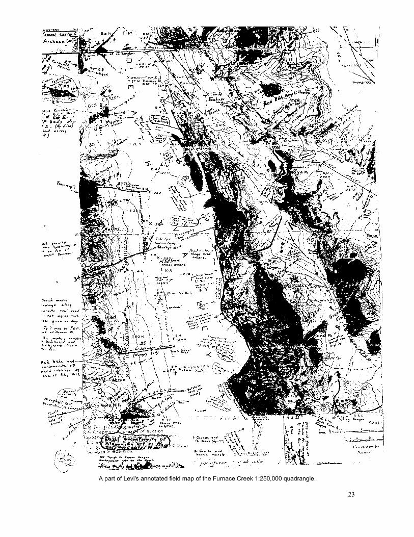
A part of Levi's annotated field map of the Furnace Creek 1:250,000 quadrangle.
23
raphic maps. Others are arranged in sweeping panoramic views, so that, today, with one of these composites in hand, one can stand approximately where he stood, and sense the challenge he felt in understanding the features before him.
Assistants Curry and Thayer
During the latter half of the 1930s Noble was assisted by younger geologists, H. Donald Curry and Tho-mas P. Thayer. In the early 1930s, Curry and Thayer had been fellow graduate students at Cal Tech. Each contributed to the Death Valley project in somewhat different ways, although each provided Noble with a map covering about 100 square miles.
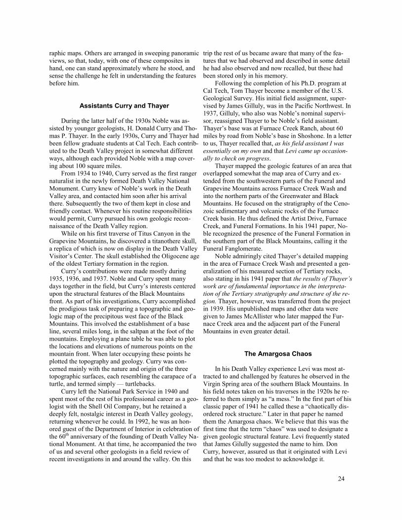
From 1934 to 1940, Curry served as the first ranger naturalist in the newly formed Death Valley National Monument. Curry knew of Noble’s work in the Death Valley area, and contacted him soon after his arrival there. Subsequently the two of them kept in close and friendly contact. Whenever his routine responsibilities would permit, Curry pursued his own geologic reconnaissance of the Death Valley region.
While on his first traverse of Titus Canyon in the Grapevine Mountains, he discovered a titanothere skull, a replica of which is now on display in the Death Valley Visitor’s Center. The skull established the Oligocene age of the oldest Tertiary formation in the region.
Curry’s contributions were made mostly during 1935, 1936, and 1937. Noble and Curry spent many days together in the field, but Curry’s interests centered upon the structural features of the Black Mountains front. As part of his investigations, Curry accomplished the prodigious task of preparing a topographic and geologic map of the precipitous west face of the Black Mountains. This involved the establishment of a base line, several miles long, in the saltpan at the foot of the mountains. Employing a plane table he was able to plot the locations and elevations of numerous points on the mountain front. When later occupying these points he plotted the topography and geology. Curry was concerned mainly with the nature and origin of the three topographic surfaces, each resembling the carapace of a turtle, and termed simply — turtlebacks.
Curry left the National Park Service in 1940 and spent most of the rest of his professional career as a geologist with the Shell Oil Company, but he retained a deeply felt, nostalgic interest in Death Valley geology, returning whenever he could. In 1992, he was an honored guest of the Department of Interior in celebration of the 60th anniversary of the founding of Death Valley National Monument. At that time, he accompanied the two of us and several other geologists in a field review of recent investigations in and around the valley. On this
trip the rest of us became aware that many of the features that we had observed and described in some detail he had also observed and now recalled, but these had been stored only in his memory.
Following the completion of his Ph.D. program at Cal Tech, Tom Thayer become a member of the U.S. Geological Survey. His initial field assignment, super-vised by James Gilluly, was in the Pacific Northwest. In 1937, Gilluly, who also was Noble’s nominal supervisor, reassigned Thayer to be Noble’s field assistant. Thayer’s base was at Furnace Creek Ranch, about 60 miles by road from Noble’s base in Shoshone. In a letter to us, Thayer recalled that, as his field assistant I was essentially on my own and that Levi came up occasion-ally to check on progress.
Thayer mapped the geologic features of an area that overlapped somewhat the map area of Curry and ex-tended from the southwestern parts of the Funeral and Grapevine Mountains across Furnace Creek Wash and into the northern parts of the Greenwater and Black Mountains. He focused on the stratigraphy of the Cenozoic sedimentary and volcanic rocks of the Furnace Creek basin. He thus defined the Artist Drive, Furnace Creek, and Funeral Formations. In his 1941 paper, Noble recognized the presence of the Funeral Formation in the southern part of the Black Mountains, calling it the Funeral Fanglomerate.
Noble admiringly cited Thayer’s detailed mapping in the area of Furnace Creek Wash and presented a generalization of his measured section of Tertiary rocks, also stating in his 1941 paper that the results of Thayer’s work are of fundamental importance in the interpreta-tion of the Tertiary stratigraphy and structure of the re-gion. Thayer, however, was transferred from the project in 1939. His unpublished maps and other data were given to James McAllister who later mapped the Furnace Creek area and the adjacent part of the Funeral Mountains in even greater detail.
The Amargosa Chaos
In his Death Valley experience Levi was most attracted to and challenged by features he observed in the Virgin Spring area of the southern Black Mountains. In his field notes taken on his traverses in the 1920s he referred to them simply as “a mess.” In the first part of his classic paper of 1941 he called these a “chaotically disordered rock structure.” Later in that paper he named them the Amargosa chaos. We believe that this was the first time that the term “chaos” was used to designate a given geologic structural feature. Levi frequently stated that James Gilully suggested the name to him. Don Curry, however, assured us that it originated with Levi and that he was too modest to acknowledge it.
24
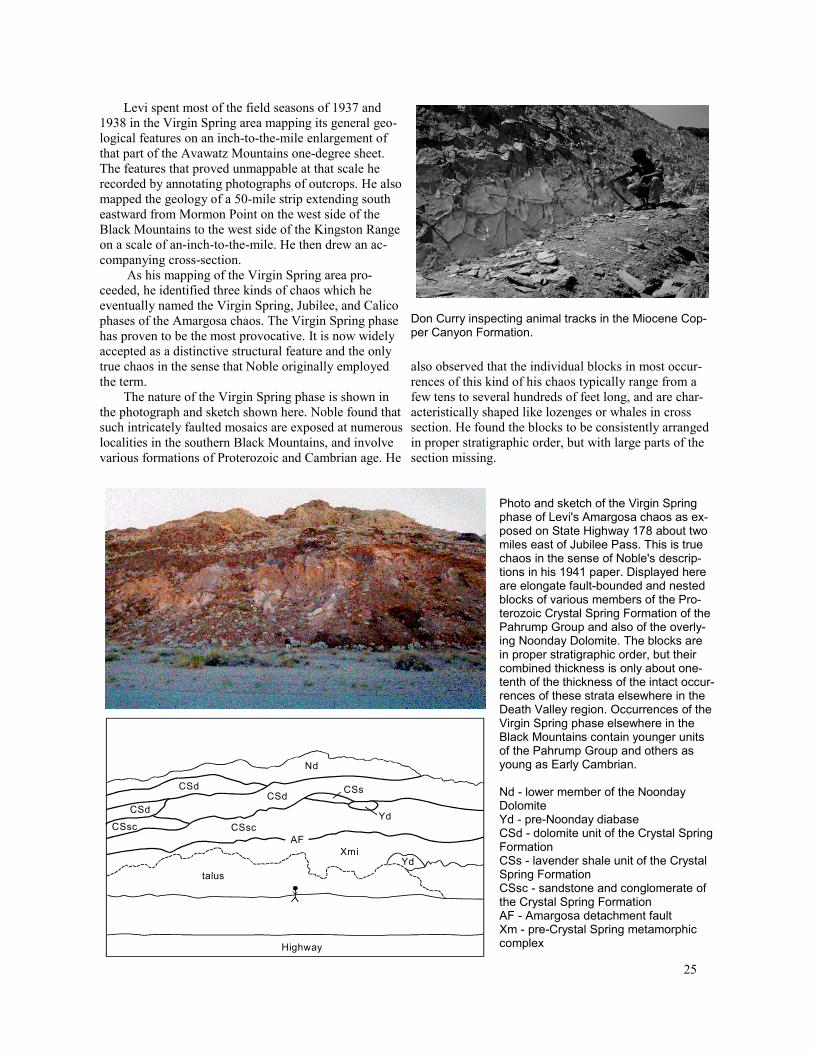
Levi spent most of the field seasons of 1937 and 1938 in the Virgin Spring area mapping its general geological features on an inch-to-the-mile enlargement of that part of the Avawatz Mountains one-degree sheet. The features that proved unmappable at that scale he recorded by annotating photographs of outcrops. He also mapped the geology of a 50-mile strip extending south eastward from Mormon Point on the west side of the Black Mountains to the west side of the Kingston Range on a scale of an-inch-to-the-mile. He then drew an accompanying cross-section.
As his mapping of the Virgin Spring area proceeded, he identified three kinds of chaos which he eventually named the Virgin Spring, Jubilee, and Calico phases of the Amargosa chaos. The Virgin Spring phase has proven to be the most provocative. It is now widely accepted as a distinctive structural feature and the only true chaos in the sense that Noble originally employed the term.
The nature of the Virgin Spring phase is shown in the photograph and sketch shown here. Noble found that such intricately faulted mosaics are exposed at numerous localities in the southern Black Mountains, and involve various formations of Proterozoic and Cambrian age. He
Don Curry inspecting animal tracks in the Miocene Cop-per Canyon Formation.
also observed that the individual blocks in most occurrences of this kind of his chaos typically range from a few tens to several hundreds of feet long, and are characteristically shaped like lozenges or whales in cross section. He found the blocks to be consistently arranged in proper stratigraphic order, but with large parts of the section missing.
Nd
CSs
Yd
Yd CSsc
talus
Highway
CSd CSd
CSsc
CSd
AF Xmi
Photo and sketch of the Virgin Spring phase of Levi's Amargosa chaos as ex-posed on State Highway 178 about twomiles east of Jubilee Pass. This is truechaos in the sense of Noble's descriptions in his 1941 paper. Displayed here are elongate fault-bounded and nestedblocks of various members of the Proterozoic Crystal Spring Formation of thePahrump Group and also of the overlying Noonday Dolomite. The blocks arein proper stratigraphic order, but theircombined thickness is only about one-tenth of the thickness of the intact occurrences of these strata elsewhere in theDeath Valley region. Occurrences of theVirgin Spring phase elsewhere in theBlack Mountains contain younger unitsof the Pahrump Group and others asyoung as Early Cambrian.
Nd - lower member of the Noonday DolomiteYd - pre-Noonday diabaseCSd - dolomite unit of the Crystal Spring FormationCSs - lavender shale unit of the Crystal Spring Formation CSsc - sandstone and conglomerate ofthe Crystal Spring FormationAF - Amargosa detachment faultXm - pre-Crystal Spring metamorphiccomplex
25

He observed that the Virgin Spring phase of his chaos is everywhere underlain by a much older and in-tact complex composed of metamorphic rocks and sub-ordinate bodies of granite and that the chaos and complex are everywhere separated by a low-angle fault. He observed, too, that the occurrences of his Virgin Spring chaos and the underlying complex are separated from one another by still later, high-angle faults and concluded that that these occurrences were once joined forming a single, continuous chaotic structural feature above the same fault. In his 1941 paper, he named this fault the Amargosa thrust.
In his mapping of the Virgin Spring area, Levi distinguished the Jubilee phase of his chaos from the other two mainly because it contains bodies of Tertiary sedimentary rocks and fragmented bodies of Tertiary granite as well as fragmented bodies of older formations. He also observed that, where present, this assemblage ordinarily overlies the Virgin Spring phase and rests upon the Precambrian complex at a few localities.
Noble found his Jubilee phase to be particularly well developed at Rainbow Mountain, about 30 miles southeast of the Virgin Spring area. Because at that time he had tentatively related the Jubilee assemblage to the fault beneath the Virgin Spring phase, he was inclined to project that fault southeastward as far as Rainbow Mountain. Consequently, in the 1941 paper, he tentatively concluded that his Amargosa thrust extended to that locality and beyond.
Noble distinguished his Calico phase from the other two mainly because it consists almost entirely of Tertiary volcanic rocks. He named it for the contrasting colors of the rock units and also for the intricacy of the faults that offset them. In the 1941 paper, however, he acknowledged that in some places the “faulting is not entirely chaotic.” He also observed that this phase, like the Jubilee phase, ordinarily overlies the Virgin Spring phase.
Putting the Chaos and its Interpretation into Words
As the years of the thirties passed, Levi published only one paper. This appeared in 1934 and was a summary of observations made during the first two years of his reconnaissance mapping. It was devoted mainly to descriptions of the various geological formations of the Death Valley region and included very little on the structural features of the region.
His silence must have seemed strange to his friends and colleagues who could recall how easily and quickly he prepared his manuscripts on the Grand Canyon, the nitrate and borate deposits of California and Nevada, and the San Andreas Fault. The reason seems clear,
however; he was simply unsure of how to represent and interpret those extraordinary structural features of the Death Valley region as a whole and the Virgin Spring area specifically.
Nevertheless, his work with the chaos had attracted the attention of his geological colleagues who visited him frequently. Foremost among them were his long-time friends Ferguson, Gilluly, Hewett, and Longwell all of whom shared his interest in the geologic evolution of the Great Basin and wished to relate his work to theirs.
His USGS overseers became concerned, however, that Levi’s manuscript might never appear. So D. F. Hewett was dispatched from Survey headquarters in Washington D.C. to Valyermo so that he might encourage Noble to produce it. Foster, as he was familiarly known, was selected for this chore partly because he had worked contemporaneously with Noble in the adjacent region on the east. He was, however, known to be some-what impatient. Whatever passed between the two of them, Foster returned to Washington empty handed, leaving a distressed Levi in Valyermo.
The assignment was then given to Henry Ferguson, the amiable Fergy and long-time friend of Levi, and it worked. They spent many days together at Valyermo and in the field discussing the geology and the organization of the paper. Ferguson’s mission was simply to en-courage the hesitant Levi to come forward with his field data and with his interpretations and to assist Levi in assembling a coherent manuscript. In our meetings with Noble in the 1950s, however, he frequently recalled that the major interpretations in the forthcoming publication grew out of his conversations with Ferguson.
Given the complexity of the geology of the chaos-bearing terrane in the area of Virgin Spring Canyon, Noble also had been faced with the problem of how best to represent the chaos on a geologic map. He finally decided to show these features simplistically, devoid of structural and stratigraphic detail and merely occupying areas on his maps. He then chose to show the complexity of the chaos through carefully worded descriptions, sketches and the thoroughly annotated photographs of key outcrops. Probably at this stage Noble and Ferguson agreed that the chaos was divisible into the three phases.
Indeed it seems to have been at this stage, and in conference with Ferguson, that Noble interpreted the Virgin Spring phase of the chaos as the lower part of the upper plate of a regional low-angle fault which they named the “Amargosa thrust.” In addition, they viewed the two overlying phases as parts of the same upper plate.
Noble then apparently reflected on how extensively these or similar features are exposed in the Death Valley region. In the latter part of the 1941 paper, he notes that he has observed them at a number of widely ranging localities, including other parts of the Black Mountains,
26
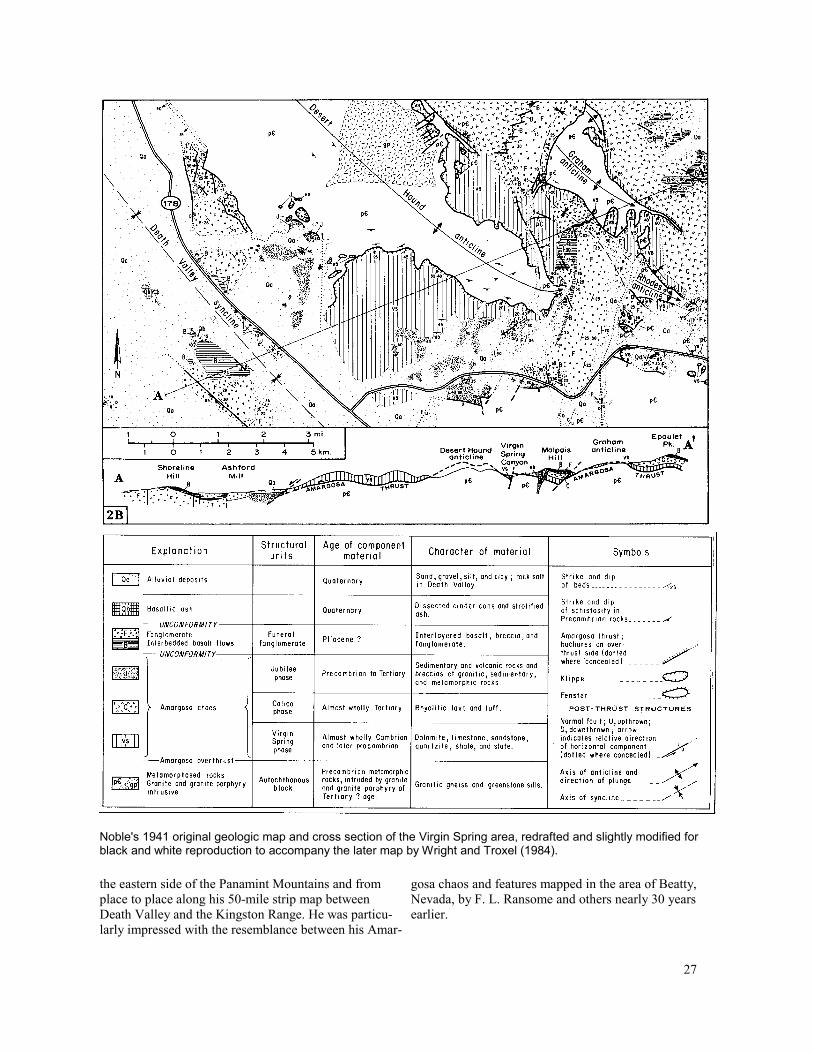
Noble's 1941 original geologic map and cross section of the Virgin Spring area, redrafted and slightly modified for black and white reproduction to accompany the later map by Wright and Troxel (1984).
the eastern side of the Panamint Mountains and from gosa chaos and features mapped in the area of Beatty,place to place along his 50-mile strip map between Nevada, by F. L. Ransome and others nearly 30 yearsDeath Valley and the Kingston Range. He was particu- earlier. larly impressed with the resemblance between his Amar-
27

The completed paper entitled “Structural features of the Virgin Spring area, Death Valley, California,” appeared in the July 1941 issue of the Bulletin of the Geological Society of America. It was quickly recognized as a major contribution to structural geology both for the spectacular nature of the chaos and the thoroughness and clarity of his descriptions and interpretations. In Levi’s files, we found scores of letters from geologists of his day, many of them distinguished, thanking him for sending a reprint and congratulating him on its content and clarity. Everyone apparently accepted his interpretations as logical. Levi, however, remained skeptical that his Amargosa “thrust” was regional in extent and even whether it was a true thrust fault. In conversations with us he frequently opined that Fergy may have led him to interpret the chaos prematurely.
World War II and the Nobles’ Sojourn in Washington D.C.
During the early 1940s, Levi Noble again assumed war-time responsibilities as he and Dorothy took temporary residence in Washington D.C. He served with the Military Geology unit of the U.S. Geological Survey on a project for the Military Intelligence Division of the Corps of Engineers. His job was to evaluate Russian, Japanese, and Chinese terrains for military operations. As he had studied the languages of these three countries simply out of interest, he needed only to refresh his knowledge of them in order to read the available literature and interpret existing geologic and topographic maps without the aid of an interpreter. During those years he seems to have been no recluse, and later en-joyed telling of his big-city experiences and of his association with distinguished USGS members of that time. In a moment of candor he even told us of a brief roman-tic interlude with his attractive instructor of Russian. He also told us that he later confessed to Dorothy and that she forgave him.
The Pearland and Valyermo Quadrangles
Following the Nobles’ return from Washington, Levi resumed his investigation of the San Andreas and related faults along the north side of the San Gabriel Mountains. Nearly 30 years had passed since he had first proposed the large-scale horizontal displacement. Mean-while this interpretation had become widely accepted. Indeed, Mason Hill and Thomas Dibblee, in another landmark paper published in 1953, speculated that as much as 350 miles of displacement could have occurred along a more northerly segment of the fault should it have been active since the end of Jurassic time.
Levi first turned to his mapping of the geology of the Pearland and Valyermo quadrangles each on a scale of 1:24,000. Each also lay across the San Andreas Fault zone and were easy access from the Valyermo Ranch. He and Dorothy must not have lived in Washington continuously during the war years as credits on the two quadrangles indicate that his fieldwork was pursued from 1940 to 1952. On the Pearland quadrangle he incorporated the mapping of Louis Gazin, which was done in 1931 and 1932. The Pearland and Valyermo quadrangles were published in 1953 and 1954, respectively, and were accompanied by lengthy explanatory texts. In this manner Levi was able to document features that were not included in his earlier papers or had been described in only a general way. Levi remained characteristically cautious on the matching of Tertiary deposits on opposite sides of the main fault.
Our Early Years with Levi Noble; His Contributions to Bulletin 170
Our association with Levi began in 1948 when Lauren Wright, then an employee of the California Division of Mines and Geology, met him on a field trip led by Robert Wallace. Wallace’s doctoral program at Cal Tech had included the mapping of a 16-mile segment of the San Andreas Fault zone lying immediately northwest of the Pearland quadrangle. Noble had intently followed Wallace’s progress and complimented him before an interested audience. As a footnote, Bob Wallace subsequently inherited Levi’s role as the preeminent scholar of the San Andreas Fault. He, too, became a member of the U.S. Geological Survey, and in 1990 edited USGS Professional Paper 1515 devoted to this feature.
Wright had first learned of Levi Noble and his Death Valley investigations in a Cal Tech structural geology seminar conducted by J. P. Buwalda in 1942. The class had read Noble’s 1941 paper on the Amargosa chaos and was scheduled to discuss it. Buwalda, who knew Noble, had invited him to attend. He warned us, however, of Noble’s shyness among strangers. So he doubted that Noble would appear, and he didn’t. But Wright clearly remembers visualizing himself as a participant in the deciphering of the geology of that fantastic region and wondering if that could happen.
Wright’s 1948 meeting with Noble led to a discussion of Wright’s own ongoing doctoral research which, in line with his earlier wish, involved an investigation of the geologic setting and origin of the commercial talc deposits of the Death Valley region.
As this endeavor was compatible with the functions of the California Division of Mines and Geology, he was able to pursue the research while employed by the State of California.
28

A reduction of part of the 1954 map by Noble and Wright. Compare with Noble’s field map on page 23.
Following their initial meeting, Noble and Wright conferred frequently both in Valyermo and in the field. Their discussions were first concerned with the geologic setting of the talc deposits and then led to considerations of the stratigraphy and structural geology of the Death Valley region. These discussions apparently helped re-kindle Levi’s Death Valley interests, especially in view of his lingering concerns with his previous interpretations of the origin of the three phases of his Amargosa chaos and the existence of a thrust fault of regional ex-tent.
Their first meeting was fortunate for still another reason, as, soon thereafter, Wright became engaged in assisting Richard H. Jahns, of Cal Tech, in assembling and editing the massive compendium “Geology of Southern California.” Jahns had arranged with Olaf Jenkins, Chief of the California Division of Mines and Geology, to publish this volume to coincide with the 1954 national meeting of the Geological Society of America in Los Angeles. To meet the 1954 deadline, scores of invited contributions had to be promptly edited and pre-pared for publication. Jenkins was at first overwhelmed and incredulous but then became an enthusiastic participant. The volume appeared, on time, as CDMG Bulletin 170.
Jahns was aware that Noble’s geologic map of the 50-mile segment of the San Andreas Fault and adjacent features remained to be published. He also was aware that most of Noble’s mapping in the Death Valley region was also unpublished. So Jahns and Jenkins, knowing of Wright’s association with Noble, delegated him to seek Noble’s participation in each of these projects. Mean-while Jenkins placed his drafting department at Noble’s immediate disposal.
Levi, now age 72, quickly agreed to prepare for publication the map of the San Andreas Fault and an accompanying text. He conditionally agreed to the Death Valley contribution provided that Wright would assist him in a geologic reconnaissance aimed at filling in the blank spaces on parts of his field maps of the Furnace Creek and Avawatz Mountains one-degree sheets. He also volunteered to redraw and revise the cross section of the 1941 paper. So with the facilities and staff of the CDMG at his disposal, Noble completed both the San Andreas Fault and the Death Valley projects well within the deadline. They were Noble’s final publications.
A comparison of the 1954 regional map of Death Valley with more modern maps of the region will show that Noble recorded virtually all of the major geological features. On it, for example, the Furnace Creek strike-
29
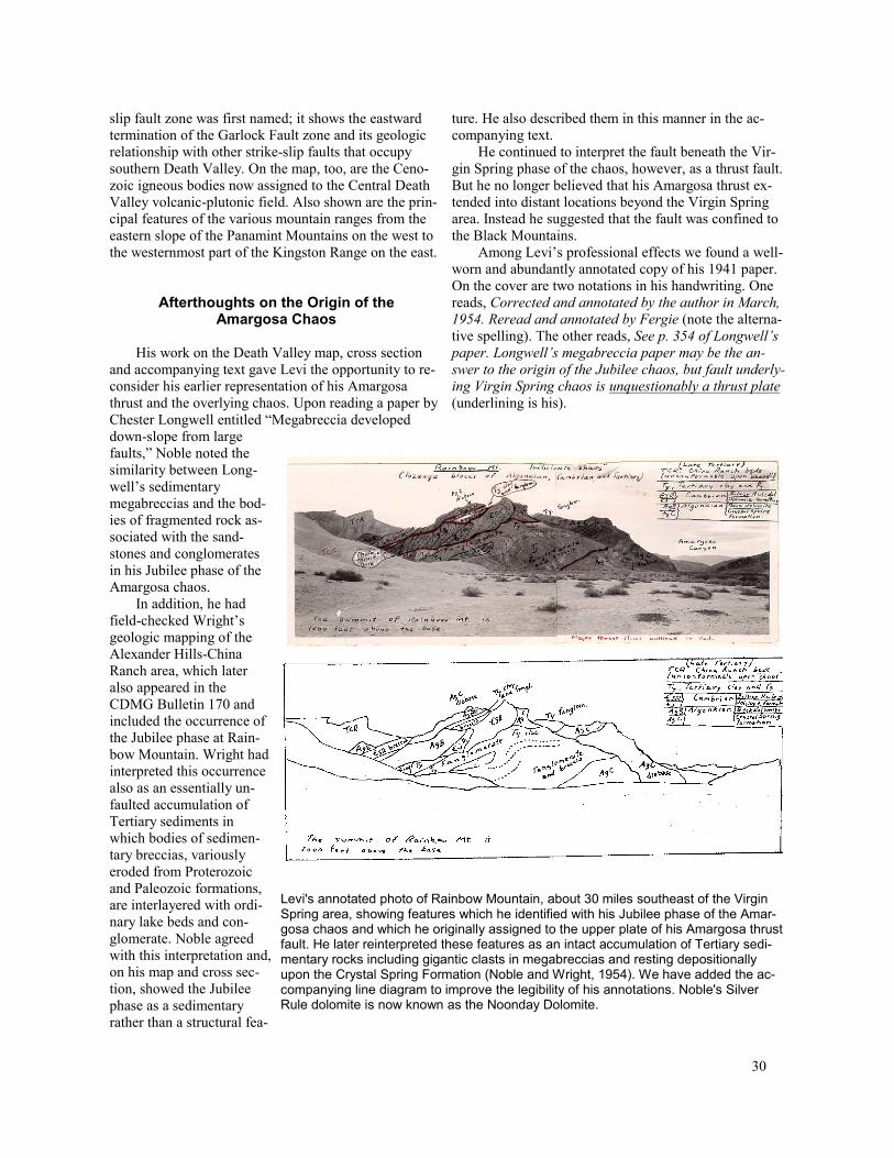
slip fault zone was first named; it shows the eastward termination of the Garlock Fault zone and its geologic relationship with other strike-slip faults that occupy southern Death Valley. On the map, too, are the Cenozoic igneous bodies now assigned to the Central Death Valley volcanic-plutonic field. Also shown are the principal features of the various mountain ranges from the eastern slope of the Panamint Mountains on the west to the westernmost part of the Kingston Range on the east.
Afterthoughts on the Origin of the Amargosa Chaos
His work on the Death Valley map, cross section and accompanying text gave Levi the opportunity to re-consider his earlier representation of his Amargosa thrust and the overlying chaos. Upon reading a paper by Chester Longwell entitled “Megabreccia developed
ture. He also described them in this manner in the accompanying text.
He continued to interpret the fault beneath the Virgin Spring phase of the chaos, however, as a thrust fault. But he no longer believed that his Amargosa thrust ex-tended into distant locations beyond the Virgin Spring area. Instead he suggested that the fault was confined to the Black Mountains.
Among Levi’s professional effects we found a well-worn and abundantly annotated copy of his 1941 paper. On the cover are two notations in his handwriting. One reads, Corrected and annotated by the author in March, 1954. Reread and annotated by Fergie (note the alternative spelling). The other reads, See p. 354 of Longwell’s paper. Longwell’s megabreccia paper may be the an-swer to the origin of the Jubilee chaos, but fault underly-ing Virgin Spring chaos is unquestionably a thrust plate (underlining is his).
down-slope from large faults,” Noble noted the similarity between Long-well’s sedimentary megabreccias and the bodies of fragmented rock associated with the sand-stones and conglomerates in his Jubilee phase of the Amargosa chaos.
In addition, he had field-checked Wright’s geologic mapping of the Alexander Hills-China Ranch area, which later also appeared in the CDMG Bulletin 170 and included the occurrence of the Jubilee phase at Rain-bow Mountain. Wright had interpreted this occurrence also as an essentially unfaulted accumulation of Tertiary sediments in which bodies of sedimentary breccias, variously eroded from Proterozoic and Paleozoic formations, are interlayered with ordinary lake beds and conglomerate. Noble agreed with this interpretation and, on his map and cross section, showed the Jubilee phase as a sedimentary rather than a structural fea-
Levi's annotated photo of Rainbow Mountain, about 30 miles southeast of the Virgin Spring area, showing features which he identified with his Jubilee phase of the Amargosa chaos and which he originally assigned to the upper plate of his Amargosa thrust fault. He later reinterpreted these features as an intact accumulation of Tertiary sedimentary rocks including gigantic clasts in megabreccias and resting depositionally upon the Crystal Spring Formation (Noble and Wright, 1954). We have added the accompanying line diagram to improve the legibility of his annotations. Noble's Silver Rule dolomite is now known as the Noonday Dolomite.
30

A person, unaware that the annotations in the body of the paper were mostly Levi’s, could easily assume that an anonymous and rather severe critic wrote them. For example, upon rereading his original description of the chaos, Levi states, Description is oversimplified and partly conjecture to which Ferguson replies, All geology is partly conjecture.
In numerous places where the Jubilee and Calico phases of his chaos are described, Levi has penciled out the term “thrust” either eliminating the word entirely from a given sentence or substituting such terms as surface of movement, advancing sheet, faulted over, and pushed away. Upon this tendency to separate these two phases of Noble’s chaos from his Amargosa thrust, Ferguson comments, I am not sure I agree with you in your elimination of the word “thrust.” Movement on a thrust may be...(illegible word)...or be largely or even entirely due to gravity. Some Swiss geologists consider the great alpine thrusts gravitational. I think I missed out in not emphasizing the gravitational factor in the Pilot Moun-tains. In this observation Ferguson seems close to interpreting Noble’s Amargosa thrust as a low-angle normal fault.
The final paragraph in Noble’s 1941 paper reads, It is thus evident that the Amargosa thrust and chaos, or structural features similar to them, are present at many places within a northwest trending belt, at least 150 miles long, and in places at least 75 miles wide, which borders and includes the Death Valley trough. The Vir-gin Spring area lies very nearly in the central part of the belt. To this statement, 13 years later, Noble writes on the margin of the annotated reprint, Ambiguous. Don't believe movement was anything like 75 miles.
In the late 1950s, Levi continued to question his earlier interpretations. In an unpublished field trip guide he wrote, In the Virgin Spring paper I assumed that the Virgin Spring chaos, Jubilee rocks, and Calico rocks formed a composite thrust plate of Pliocene age. This hypothesis doesn’t look so good right now, but it still remains to be completely knocked out.
In our conversations with Levi in the late 1950s he frequently recalled his 1954 brainstorming sessions with Ferguson. He especially recalled their semi-serious discussions of the origin of the Tertiary conglomerates and sandstones in the Jubilee phase of the chaos. They speculated that at least some of these sediments could have been eroded from an advancing thrust sheet and then buried as the sheet moved over them. They mused that these sediments might be analogous to a litter of newly born piglets who died as the mother sow rolled over them. So the two friends also mused that such a deposit could be called “necrogenite.” We have seen this term, however, only in their written communications.
Additional Memories of Levi and Dorothy in their Later Years
In 1952, at about the time that Levi submitted his two contributions to the editors of Bulletin 170, Bennie Troxel joined Wright in the Los Angeles office of the California Division of Mines and Geology. Troxel had just completed his Master’s degree at University of California, Los Angeles, and was keenly interested in Basin and Range geology. Our first joint contribution consisted of a geologic guide to the western part of the Mojave Desert and the Death Valley region for the CDMG Bulletin 170. It was to be used on a field trip planned for the GSA meeting and led by Bob Sharp of California Institute of Technology. In it we drew heavily on information provided by Levi Noble in his two contributions.
Soon after Troxel’s arrival Wright introduced him to Levi, and he began to join the two of us on long weekends in the southern Death Valley region, especially to visit localities where Levi had recognized the chaos. These were more than pleasure trips to Levi as he frequently expressed his dissatisfaction with his earlier interpretations and wished to re-inspect key exposures of the chaos.
Levi conferring with younger geologists involved in the Death Valley field trip for the 1954 national meeting of the Geological Society of America in Los Angeles; Dick Jahns standing, Bob Sharp left, Bennie Troxel center.
During the early to mid 1950s, the access roads into the backcountry of the Death Valley region remained in reasonably good condition so that even a sedan could be driven to numerous localities that are now inaccessible to wheeled vehicles for various reasons. Moreover, it was now possible to map the chaos of the Virgin Spring area in moderate detail on a 4-times enlargement of the new Confidence Hills 15-minute quadrangle. So he encouraged us to do this. In accepting, we naturally felt both honored and privileged.
Levi, in his early to mid 70s, was becoming some-what frail. We would drive to a locality that he remembered well and contained features that he believed to be
31
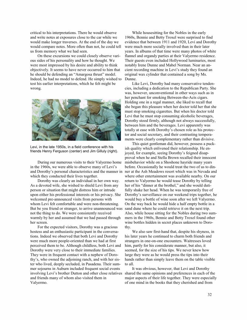
critical to his interpretations. There he would observe and write notes at exposures close to the car while we would make longer traverses. At the end of the day we would compare notes. More often than not, he could tell us from memory what we had seen.
On these excursions we could closely observe various sides of his personality and how he thought. We were most impressed by his desire and ability to think objectively. It seems to have never occurred to him that he should be defending an “Amargosa thrust” model. Indeed, he had no model to defend. He simply wished to test his earlier interpretations, which he felt might be wrong.
Levi, in the late 1950s, in a field conference with his friends Henry Ferguson (center) and Jim Gilluly (right).
During our numerous visits to their Valyermo home in the 1960s, we were able to observe many of Levi’s and Dorothy’s personal characteristics and the manner in which they conducted their lives together.
Dorothy was clearly an individual in her own way. As a devoted wife, she wished to shield Levi from any person or situation that might distress him or intrude upon either his professional interests or his privacy. She welcomed pre-announced visits from persons with whom Levi felt comfortable and were non-threatening. But be you friend or stranger, to arrive unannounced was not the thing to do. We were consistently received warmly by her and assumed that we had passed through her screen.
For the expected visitors, Dorothy was a gracious hostess and an enthusiastic participant in the conversations. Indeed we observed that both Levi and Dorothy were much more people-oriented than we had at first perceived them to be. Although childless, both Levi and Dorothy were very close to their immediate families. They were in frequent contact with a nephew of Dorothy’s, who owned the adjoining ranch, and with her sister who lived, deeply secluded, in Pasadena. Their summer sojourns in Auburn included frequent social events involving Levi’s brother Dutton and other close relatives and friends many of whom also visited them in Valyermo.
While housesitting for the Nobles in the early 1960s, Bennie and Betty Troxel were surprised to find evidence that between 1911 and 1920, Levi and Dorothy were much more socially involved than in their later years. In albums of that time were many photos of white flannel and organdy parties at their Valyermo residence. Their guests even included Hollywood luminaries, most notably Irene Dunne and Mabel Norman. Near an ancient recording machine in Levi’s study they found an original wax cylinder that contained a song by Ms. Dunne.
Like Levi, Dorothy had many conservative tendencies, including a dedication to the Republican Party. She was, however, unconventional in other ways such as in her penchant for smoking Between-the-Acts cigars. Holding one in a regal manner, she liked to recall that she began this pleasure when her doctor told her that she must stop smoking cigarettes. But when his doctor told Levi that he must stop consuming alcoholic beverages, Dorothy stood firmly, although not always successfully, between him and the beverages. Levi apparently was totally at ease with Dorothy’s chosen role as his protector and social secretary, and their contrasting temperaments were clearly complementary rather than divisive.
This quiet gentleman did, however, possess a puckish quality which enlivened their relationship. He en-joyed, for example, seeing Dorothy’s feigned disapproval when he and Stella Brown recalled their innocent misbehavior while on a Shoshone hayride many years before. Occasionally he would treat the two of us to dinner at the Ash Meadows resort which was in Nevada and where other entertainment was available nearby. On our return to Valyermo he would tease Dorothy by telling her of his “dinner at the brothel,” and she would dutifully shake her head. When he was temporarily free of Dorothy’s surveillance on our weekend trips together, he would buy a bottle of wine soon after we left Valyermo. On the way back he would hide a half empty bottle in a sand dune where he could retrieve it on the next trip. Also, while house sitting for the Nobles during two summers in the 1960s, Bennie and Betty Troxel found other wine bottles hidden in secret places unknown to Dorothy.
We also saw first-hand that, despite his shyness, in his later years he continued to charm both friends and strangers in one-on-one encounters. Waitresses loved him, partly for his considerate manner, but also, it seemed, for the size of his tips. We never knew how large they were as he would press the tips into their hands rather than simply leave them on the table visible to all.
It was obvious, however, that Levi and Dorothy shared the same opinions and preferences in each of the major aspects of their life together. They were especially of one mind in the books that they cherished and from
32
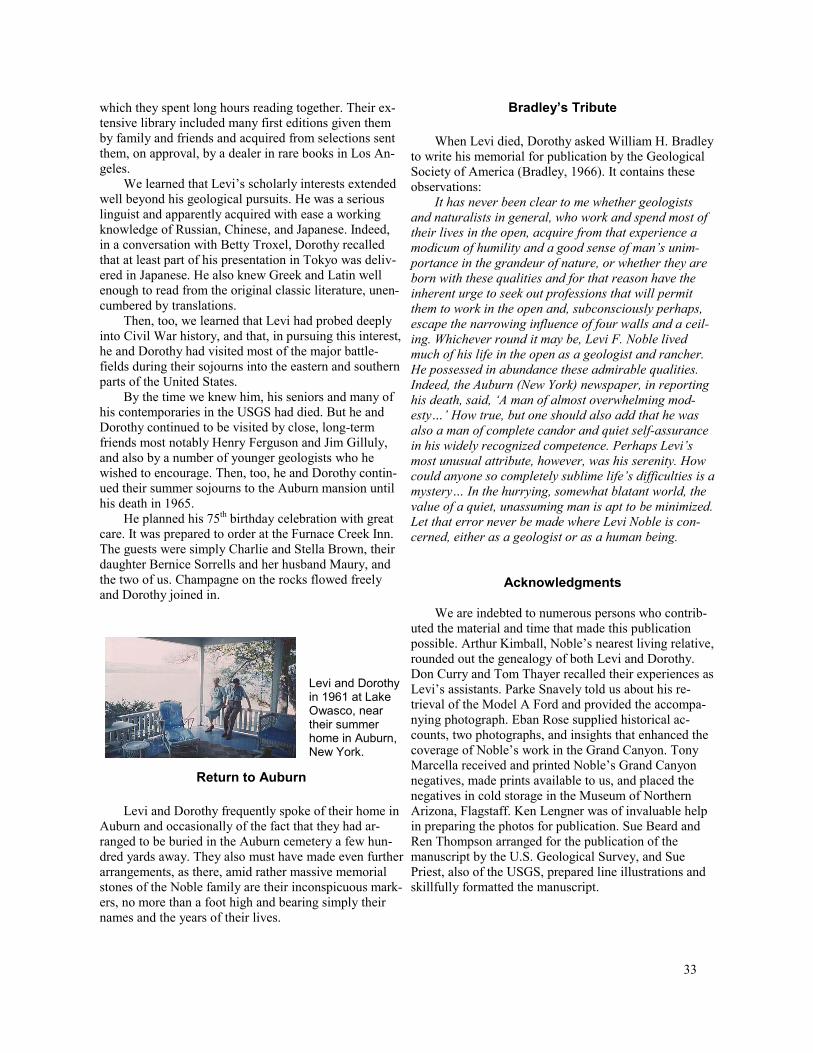
which they spent long hours reading together. Their extensive library included many first editions given them by family and friends and acquired from selections sent them, on approval, by a dealer in rare books in Los Angeles.
We learned that Levi’s scholarly interests extended well beyond his geological pursuits. He was a serious linguist and apparently acquired with ease a working knowledge of Russian, Chinese, and Japanese. Indeed, in a conversation with Betty Troxel, Dorothy recalled that at least part of his presentation in Tokyo was delivered in Japanese. He also knew Greek and Latin well enough to read from the original classic literature, unencumbered by translations.
Then, too, we learned that Levi had probed deeply into Civil War history, and that, in pursuing this interest, he and Dorothy had visited most of the major battle-fields during their sojourns into the eastern and southern parts of the United States.
By the time we knew him, his seniors and many of his contemporaries in the USGS had died. But he and Dorothy continued to be visited by close, long-term friends most notably Henry Ferguson and Jim Gilluly, and also by a number of younger geologists who he wished to encourage. Then, too, he and Dorothy continued their summer sojourns to the Auburn mansion until his death in 1965.
He planned his 75th birthday celebration with great care. It was prepared to order at the Furnace Creek Inn. The guests were simply Charlie and Stella Brown, their daughter Bernice Sorrells and her husband Maury, and the two of us. Champagne on the rocks flowed freely and Dorothy joined in.
Levi and Dorothy in 1961 at Lake Owasco, near their summer home in Auburn, New York.
Return to Auburn
Levi and Dorothy frequently spoke of their home in Auburn and occasionally of the fact that they had arranged to be buried in the Auburn cemetery a few hundred yards away. They also must have made even further arrangements, as there, amid rather massive memorial stones of the Noble family are their inconspicuous markers, no more than a foot high and bearing simply their names and the years of their lives.
Bradley’s Tribute
When Levi died, Dorothy asked William H. Bradley to write his memorial for publication by the Geological Society of America (Bradley, 1966). It contains these observations:
It has never been clear to me whether geologists and naturalists in general, who work and spend most of their lives in the open, acquire from that experience a modicum of humility and a good sense of man’s unim-portance in the grandeur of nature, or whether they are born with these qualities and for that reason have the inherent urge to seek out professions that will permit them to work in the open and, subconsciously perhaps, escape the narrowing influence of four walls and a ceil-ing. Whichever round it may be, Levi F. Noble lived much of his life in the open as a geologist and rancher. He possessed in abundance these admirable qualities. Indeed, the Auburn (New York) newspaper, in reporting his death, said, ‘A man of almost overwhelming mod-esty…’ How true, but one should also add that he was also a man of complete candor and quiet self-assurance in his widely recognized competence. Perhaps Levi’s most unusual attribute, however, was his serenity. How could anyone so completely sublime life’s difficulties is a mystery… In the hurrying, somewhat blatant world, the value of a quiet, unassuming man is apt to be minimized. Let that error never be made where Levi Noble is con-cerned, either as a geologist or as a human being.
Acknowledgments
We are indebted to numerous persons who contributed the material and time that made this publication possible. Arthur Kimball, Noble’s nearest living relative, rounded out the genealogy of both Levi and Dorothy. Don Curry and Tom Thayer recalled their experiences as Levi’s assistants. Parke Snavely told us about his retrieval of the Model A Ford and provided the accompanying photograph. Eban Rose supplied historical accounts, two photographs, and insights that enhanced the coverage of Noble’s work in the Grand Canyon. Tony Marcella received and printed Noble’s Grand Canyon negatives, made prints available to us, and placed the negatives in cold storage in the Museum of Northern Arizona, Flagstaff. Ken Lengner was of invaluable help in preparing the photos for publication. Sue Beard and Ren Thompson arranged for the publication of the manuscript by the U.S. Geological Survey, and Sue Priest, also of the USGS, prepared line illustrations and skillfully formatted the manuscript.
33

Addenda
A. Following Levi’s death in the summer of 1965, we continued to map the chaos in various localities in the southern Death Valley region. In 1973 we published our interpretation of the Virgin Spring phase of the chaos as a product of extreme crustal extension, and of the underlying fault as a low-angle normal fault. We later completed our mapping of the northern half of the Confidence Hills quadrangle. It was published in 1984 as Map Sheet 34 of the California Division of Mines and Geology. Through this map and in the accompanying text we elaborated upon these interpretations. The entire Death Valley region is now widely recognized as re-cording large-scale Late Cenozoic extension. Had Levi Noble survived until these later years, we feel he would have agreed. Moreover, if these interpretations are correct, it seems clear that Levi provided the geological profession of his time with the first detailed description of what is now also known as an extensional detachment surface.
B. Noble neglected, perhaps intentionally, to pro-vide a concise definition of the term “chaos.” But the following definition, based on Levi’s published descriptions, appears in “Glossary of Geology, 4th edition” published by the American Geological Institute, 1997: A structural term proposed by Noble (1941, p. 963-977) for a gigantic breccia associated with thrusting, consist-ing of a mass of large and small blocks of irregular shape with very little fine-grained material, in a state of semi-disorder. Type example: the Amargosa chaos, a widespread deposit in the Death Valley area of Califor-nia, consisting of an extremely complex mosaic of enor-mous, tightly packed, often unshattered, but internally coherent, random blocks and masses of formations of different ages occupying a definite zone above a major thrust fault. The blocks range in size from pods a meter in diameter to blocks more than 800 m in length.
This description seems to refer to the features of Levi’s Virgin Spring phase of his Amargosa chaos although the blocks within it are not random. Noble clearly recognized the distinction between it and the Jubilee and Calico phases in his later years. But this definition also is inaccurate because (1) as stated above, the chaos is now widely interpreted as an extensional feature; (2) the blocks that compose it are derived from stratigraphic successions and are arranged in proper stratigraphic order; and (3) the blocks are nested, elongate and ordinarily parallel with the underlying fault. In addition, the thickness the resulting mosaic of fault-bounded blocks is only a small fraction of the thickness of the original stratigraphic succession.
We suggest the following definition: A structural term for a mosaic of fault-bounded, commonly gigantic
blocks derived from a stratigraphic succession, and arranged in proper stratigraphic order, but occupying only a small fraction of the thickness of the original succession. In the Death Valley region, where L. F. Noble coined the term, chaos is widely viewed as a product of extreme crustal extension.
C. Whether or not Levi viewed his Amargosa thrust as a product of crustal compression remains unclear. In the early part of the 1900s it was almost axiomatic that low-angle faults were assumed to be thrust faults and to record crustal compression. Nowhere in the 1941 paper did he specifically identify his Amargosa thrust with contemporaneous crustal shortening as ex-pressed by folding or the transport of older over younger rocks. He did, however, describe his Amargosa thrust as broadly folded following the horizontal displacement. Ferguson’s suggestion, in their exchange of annotations in 1954 — that the Amargosa thrust may have been gravity driven — also suggests that the two of them had found no evidence of contemporaneous shortening in the underlying crust. Indeed, the term “thrust” continues to be imprecisely defined. In the 4th edition of the Glossary of Geology, American Geological Institute, we find the following definition: (a) An overriding movement of one crustal unit over another as in thrust-faulting. (b) thrust fault.
D. We present here the contents of a letter, ad-dressed to Levi Noble, which we found posthumously in Levi’s files. It is signed “F. Dodge” and written long-hand on Rockefeller Center letterhead. The writer was obviously a contemporary of Levi’s, a fellow Yale alum-nus and a valued friend of the Nobles’. We suspect he may also have been a relative of Dorothy. The lampoon will be best understood by readers familiar with the geological features described in Levi’s 1941 paper on the Virgin Spring area. But more than anything else the letter conveys the warmth and self-deprecating, gentle humor that passed between Levi and his close friends.
I have just finished reading a bulletin of the Geo-logical Society of America entitled “Structural Features of the Virgin Spring Area, Death Valley, California,” by Levi F. Noble.
Well, as a treatise on a geological subject, it is of course only a minor contribution, as Gregory used to say, ‘replete with error.’ For instance, Noble’s remarks on clay gouge are obviously indefensible, as is his the-ory of the nature of the core of the Panamint Mountains. Then, his interpretation of the post-Funeral faulting of the area, particularly as to the Jubilee fault, is glaringly unsound. Moreover, in 1929, I myself found in the Amargosa chaos several blocks of Murphy’s Telescope Peak group of pre-Cambrian rocks occurring in the Panamint Range, which Noble seems to have missed.
34
But perhaps they were removed since I was there. I will give him the benefit of the doubt. Finally many of his other deductions in the field of mountain making and dynamic geology are at least open to serious question.
So much for geology. But let us look at the paper in another light. What a movie scenario it would make! What a drama of Sturm und Drang! There is in it all the tragedy, the bitterness, the hopelessness of a Russian novel, filled with reverse faults, plunging anticlines, in-truding dikes, denudation, mashing and other deformi-ties and disorders. The work is written in a style so sim-ple, yet in a language so charged with stark horror in spite of its simplicity that I hope that much of the origi-nal text will be retained to lend color to the cinema ver-sion.
Certain passages stand out — simple English yet terrible in its elemental dreadfulness. Listen, for in-stance, to the description of the dikes of quartz latite porphyry on page 963. I quote: ‘the feldspar phenocrysts have cores of sanidine and rims of albite.’ Why! The blood runs cold at the thought. Even though we are told that the albite is secondary and the cause of the albitization is unknown, nevertheless the sense of horror remains with us to the end.
And on page 967, he says that the Cambrian Johnnie formation (I quote): ‘is part of a sequence of competent and incompetent beds ideally adapted to fold-ing.’ Simple, yet withal how seething with tragedy! A folding bed is of itself an instrument of torture, but what diseased mind could conceive of the horror implicit in an incompetent bed? The brain reels at the thought!
On page 982 (I quote): ‘ Some of the breccia grades laterally from large masses of fractured rock through finer textured breccia to unstratified fanglomerate to stratified fanglomerate.’ Heavens! Gertrude Stein could do no better, if you know what I mean. I don’t and I don’t believe Noble did either. Was it not William James who spoke of the “horror of the meaningless?”
I will leave the scenario and the casting to others more competent, but a few of the principal characters should be pointed out. Amargosa J. Pressure had three daughters: Virgin, Jubilee, and Calico, thrusting, disor-ganized viragos, conceived in chaos by his wife Orogeny at the time of the great Miocene overthrust. The three girls were not, as Noble correctly says (as he occasion-ally does), out of the same litter, but were created some time apart, as is shown by their superposition. Aside, however, from some differences in color and composi-tion, which give rise to the assumption that they may have had different mothers, they all have the same de-moniacal, uncontrolled character. Confused, distorted, impossible to map, their faces a bizarre mosaic of het-erogeneous materials, fractured minutely throughout, they are in reality Cyclopean breccias overlaid with ero-sional unconformity. Nice gals!
Virgin remained in contact with both her sisters, but Calico, though she is seen frequently with Virgin, re-mained on the outs with Jubilee, and is found for the most part, lurking in the hinterland of the Graham anti-cline.
Their days of youth were short, however. Their rela-tionships, as well as their characters, became disturbed through folding and faulting and, with the dawn of the Pliocene (according to Noble’s rather vague guess) they disappeared. Their mortician was called the Funeral Fanglomerate (the pun is Noble’s, not mine), and later they were reburied under the basaltic ash, rock salt, and alluvia of the Quaternary age. Then the world knew them no more, not even from their outcrops, until Noble of Valyermo brought them again to the notice of a palpi-tating world.
But enough of the Overthrust girls. The outstanding character of the story is not any of the Amargosa family. It is the fateful figure of Fanny Glomerate, the woman of mystery. Whence did she come? From the Funeral Mountains, as Noble naively suggests? From the Epsom Salts Works, the hideout of our old friend Maggie Sulph? Perhaps she came from the San Andreas rift (this, of course, is meaningless but is merely inserted to give Noble another plug). No one really knows or cares.
Who was her father? Noble timidly votes for Papa Pliocene. Too late. Could it be old Miocene? Obviously not. But in a Bulletin of the Geological Society of Amer-ica (vol. 15, pp. 901-2), H. Dodge, a mere amateur, be-lieves him to be old man Mesozoic himself, who had many sedimentary offspring in his later Cretaceous or reptilian years. Dodge is probably right, as usual.
Fanny outcrops in many places throughout the story, near Gregory Peak, on the Confidence Hills anti-cline, in far-off Bradbury klippe, and, low character that she is, is even found nesting in the Malpais Hill syncline. Whenever she appears in the plot she is a figure of mys-tery, of instability, of lies, of deceptions.
She has all the bad traits. Unconformable, poorly consolidated, in beds with basalts (whoever he is), torn by faults (though I admit most of them are normal), often coarse, she glides through the pages of the book like a malign fate. Sometimes she lies on the Amargosa chaos. Sometimes she lies on the pre-Cambrian gneiss. But — mark her well — she always lies. She is a very Proteus, fickle and changeable, sometimes stratified, sometimes unstratified. Sometimes she lies exposed. Sometimes, in her more modest moments, she lies, (I quote from Noble) 'covered with a thin veneer of Quaternary alluvia.’ Sometimes she is black, sometimes red, sometimes grey or buff, according to her mood. Her primary character-istic, however, which may be mere laziness but which may be more venial — she is always well bedded.
There are plenty of villains in this drama of the chaos. But throughout the ages the story has lacked—a
35

hero. It remained for Noble of South Street, Auburn, New Haven, Valyermo, and points west, plodding under pith helmet through the salt flats and alkali dust of the Death Valley syncline or slinking stealthily into Mother Wood’s saloon for a couple of quartz or quartzites, to lay bare the secrets of this geological epic and become himself the hero of the Amargosa Overthrust. I thank you.
References
Bradley, W. H., 1966, Memorial to Levi Fatzinger Noble (1882-1965): Geological Society of America Bulletin, v. 77, p. 49-52.
Brian, Nancy, 1992, River to run: Earthquest Press, Flagstaff, Ariz., 176 p.
Curry, H. D. 1954, Turtlebacks of the central Black Mountains, Death Valley, California, in Jahns, R. H., ed., Geology of Southern California: California Division of Mines Bulletin 170, chapter IV, p. 53-59.
Gregory, H. E., and Noble, L. F., 1923, Notes on a geological traverse from Mohave, California to the mouth of the San Juan River, Utah: American Journal of Science, v. 5, p. 229-238.
Hess, F. L., 1909, Gold mining in the Randsburg quadrangle, California: U.S. Geological Survey Bulletin 439, part I, p. 25.
Hewett, D. F., 1931, Geology and ore deposits of the Goodsprings quadrangle, Nevada: U.S. Geological Survey Professional Paper 162, 172 p.
Hewett, D. F., 1956, Geology and mineral resources of the Ivanpah quadrangle, Nevada-California: U.S. Geological Survey Professional Paper 275, 172 p.
Hill, M. L., and Dibblee, T. W., 1953, San Andreas, Garlock, and Big Pine Faults, California: A study of the character, history, and tectonic significance of their displacements: Geological Society of America Bulletin, v.64, p. 443-458.
Jackson, J. A., ed., 1997, Glossary of Geologic Terms: 4th edition, American Geological Institute, p. 108.
Knott, J. R., 2001, Field trip guide for day C, central Death Valley, Stop C1.6: in Machette, M. N., John-son, M. L., and Slate, J. L., eds., Quaternary and late Pliocene geology of the Death Valley region: Recent observations on tectonics, stratigraphy, and lake cycles (Guidebook for the 2001 Pacific Cell — Friends of the Pleistocene field trip), U.S. Geological Survey Open-File Report 01-51, p. C99.
Longwell, C. R., 1951, Megabreccia developed downslope from large faults: American Journal of Science, v. 249, p. 343-355.
McAllister, J. F., 1970, Geologic map and sections of the Furnace Creek borate area, Death Valley, Cali
fornia: California Division of Mines and Geology Map Sheet 14.
McAllister, J. F., 1973, Geologic map and sections of the Amargosa Valley borate area – southeast continuation of the Furnace Creek area, Inyo County, California: U.S. Geological Survey Miscellaneous Investigations Map I-782.
Noble, L. F., 1910, Contributions to the geology of the Grand Canyon, Arizona – The geology of the Shinumo area: American Journal of Science, 4th
ser., v. 29, p. 369-386. ____, 1911, The Grand Canyon of the Colorado: Sci
ence, v. 34, p. 378-380. ____, 1914, The Shinumo quadrangle, Grand Canyon
district, Arizona: U.S. Geological Survey Bulletin 549, 100 p.
____, 1918, Geologic history of the Bright Angel quadrangle, Arizona: Text on back of topographic sheet, Bright Angel quadrangle, Arizona (Coconino County): U.S. Geological Survey.
____, 1922a, A section of the Paleozoic formations of the Grand Canyon at Bass Trail: U.S. Geological Survey Professional Paper 131-B, p. 23-73.
____, 1922b, Colemanite in Clark County, Nevada: U.S. Geological Survey Bulletin 735, p. 23-39.
____, 1926a, Borate deposits in the Kramer district, Kern County, California: U.S. Geological Survey Bulletin 785, p. 45-61.
____, 1926b, Note on a colemanite deposit near Shoshone, California, with a sketch of the geology of a part of the Amargosa Valley: U.S. Geological Survey Bulletin 785, p. 63-73.
____, 1927, The San Andreas rift and some other active faults in the desert region of southeastern California: Report on the advisory committee in seismology, Carnegie Institute of Washington, Yearbook 25, 1925-1926, p. 415-428.
____, 1928a, The San Andreas rift in a part of southern California: Third Pan-Pacific Science Congress, Tokyo, 1926, Proceedings, p. 394-400.
____, 1928b, A section of the Kaibab limestone in Kaibab Gulch, Utah: U.S. Geological Survey Professional Paper 150, p. 41-60.
____, 1931, Nitrate deposits in southeastern California, with notes on deposits in southeastern Arizona and southwestern New Mexico: U.S. Geological Survey Bulletin 820, 108 p.
____, 1932, The San Andreas rift in the desert region of southern California: Carnegie Institute of Washing-ton, Yearbook 31, p. 355-363.
____, 1933, Excursion to the San Andreas Fault and Cajon Pass, in Gale, H. S., ed., Southern California: 16th International Geological Congress, Guidebook 15, 68 p.
36

____, 1941, Structural features of the Virgin Spring area, Death Valley, California: Geological Society of America Bulletin, v. 52, p. 941-1000.
____, 1953, Geology of the Pearland quadrangle, California: U.S. Geological Survey, Geologic Quadrangle Map GQ 24.
____, 1954a, Geology of the Valyermo quadrangle, California: U.S. Geological Survey Geologic Quadrangle Map GQ 50.
____, 1954b, The San Andreas Fault zone from Soledad Pass to Cajon Pass, California, in Jahns, R. H., ed., Geology of Southern California: California Division of Mines Bulletin 170, chapter IV, p. 37-48.
Noble, L. F., and Hunter, J. F., 1916, A reconnaissance of the Archean complex of the Granite Gorge, Grand Canyon, Arizona: U.S. Geological Survey Professional Paper 98-I, p. 95-113.
Noble, L. F., Mansfield, G. R., and others, 1922, Nitrate deposits in the Amargosa region, southeastern California: U.S. Geological Survey Bulletin 724, 99 p.
Noble, L. F., and Wright, L. A., 1954, Geology of the central and southern Death Valley region, California, in Jahns, R. H., ed., Geology of Southern California: California Division of Mines Bulletin 170, chapter II, p. 143-160.
Ransome, F. L., Emmons, W. H., and Garry, G. H., 1910, Geology and ore deposits of the Bullfrog district, Nevada: U.S. Geological Survey Bulletin 407, 130 p.
Walcott, C. D., 1883, Pre-Carboniferous strata in the Grand Canyon of the Colorado, Arizona: American Journal of Science, 3rd series, v. 26, p. 437-442.
Walcott, C. D., 1894, Pre-Cambrian igneous rocks of the Unkar terrane, Grand Canyon of the Colorado, Arizona, with notes on the petrographic character of the lavas by J. P. Iddings, U.S. Geological Survey Fourteenth Annual Report, part 2, p. 497-519, 520-524.
Wallace, R. E., 1949, Structure of a portion of the San Andreas rift in southern California: Geological Society of America Bulletin, v. 60, p. 781-806.
Wallace, R. E. ed., 1990, The San Andreas Fault system, California: U.S. Geological Survey Professional Paper 1515, 283 p.
Wright, L. A., 1954, Geology of the Alexander Hills area, Inyo and San Bernardino Counties, in Jahns, R. H., ed., Geology of Southern California: California Division of Mines Bulletin 170, Map Sheet 17.
____, 1974, Geology of the southeast quarter of the Tecopa quadrangle, Inyo County, California: California Division of Mines and Geology Map Sheet 20.
Wright, L. A., and Troxel, B. W., 1954, Geologic guide no. 1, Western Mojave Desert and Death Valley region, in Jahns, R. H., ed., Geology of Southern California: California Division of Mines Bulletin 170, 50 p.
____, 1973, Shallow-fault interpretation of Basin and Range structure, in DeJong, K. A. and Scholten, R., eds., Gravity and Tectonics: New York, John Wiley and Sons, Inc., p. 397-407.
____, 1984, Geology of the northern half of the Confidence Hills 15-minute quadrangle, Death Valley region, eastern California: California Division of Mines and Geology Map Sheet 34.
____, 1992, Levi Noble, pioneer geologist of the Death Valley region, in Pisarowicz, J., ed., Proceedings Third Death Valley Conference on History and Pre-history, p. 143-157.
____, 1999, Levi Noble’s Death Valley, a 58-year perspective, in Moores, E. M., Sloan, D., and Stout, D. L., eds., Classic Cordilleran concepts: A view from California: Geological Society of America Special Paper 338, p. 399-411.
37
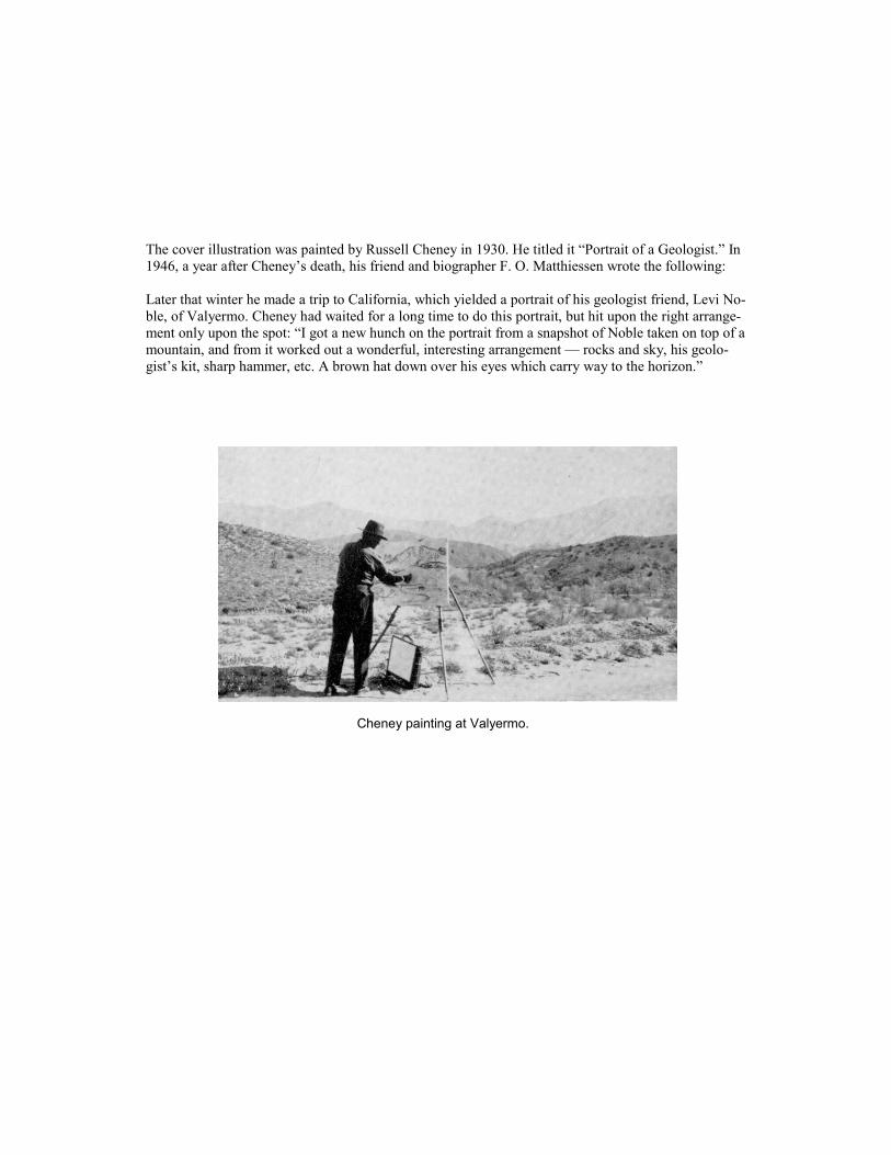
The cover illustration was painted by Russell Cheney in 1930. He titled it “Portrait of a Geologist.” In 1946, a year after Cheney’s death, his friend and biographer F. O. Matthiessen wrote the following:
Later that winter he made a trip to California, which yielded a portrait of his geologist friend, Levi Noble, of Valyermo. Cheney had waited for a long time to do this portrait, but hit upon the right arrangement only upon the spot: “I got a new hunch on the portrait from a snapshot of Noble taken on top of a mountain, and from it worked out a wonderful, interesting arrangement — rocks and sky, his geologist’s kit, sharp hammer, etc. A brown hat down over his eyes which carry way to the horizon.”
Cheney painting at Valyermo.