leica gb 2004 report enmetrology.leica-geosystems.com/en/...annualreport... · the corporate...
TRANSCRIPT

Annual ReportFiscal Year 2005
- when it has to be right
A Year of Success

Three-Year Overview
EBITDA(Continuing)
Net income(Continuing)
Sales by divisionSales(Continuing)
Sales in CHF million
Currency-adjusted sales growth in %
Sales growth in %
EBITDA in CHF million
EBITDA of sales in %
In CHF million
FY03 FY04 FY05 FY03 FY04 FY05 FY03 FY04 FY05
773
689
650
0
900
750
600
450
300
150
0 128
99
80
0
120
100
80
60
40
20
0
515
–14
60
50
40
30
20
10
0
10
20
16.6
12.3
14.3
12.26.0–2.0
7.915.5
–8.8
Surveying & Engineering 64%
GIS & Mapping 12%
Metrology 9%
Consumer Products 8%
High-Definition Surveying 4%Special Products 3%
Profit & lossUnless otherwise stated amounts for Continuing Operations in CHF million/Year ended March 31 2005 2004 2003Sales 773.2 689.1 650.3Year-on-Year Growth 12.2% 6.0% (8.8%)Currency-Adjusted Growth 15.5% 7.9% (2.0%)Gross-Profit 409.9 352.6 336.3Gross-Profit Margin 53.0% 51.2% 51.7%Total Operating Expenses (338.7) (324.8) (326.5)Earnings before Interest and Taxes (EBIT) 71.6 29.5 7.3EBIT Margin 9.3% 4.3% 1.1%Net Income/(Loss) – Continuing Operations 50.6 5.2 (13.7)Depreciation of Fixed Assets 18.8 18.0 21.1IAS 38 Amortization 37.6 34.4 31.1Goodwill Amortization1 – 16.9 21.9EBITDA 128.1 98.7 80.3EBITDA Margin 16.6% 14.3% 12.3%Adjusted EBITDA2 102.3 60.4 39.1Adjusted EBITDA Margin 13.2% 8.8% 6.0%Net Income from Discontinued Operations – 0.4 35.6Total Net Income 50.6 5.6 21.9Basic EPS (in CHF) 22.27 2.54 9.80Fully Diluted EPS (in CHF) 21.57 2.48 9.78
Balance sheet & cash flowNet Working Capital 127.9 121.1 112.1Net Working Capital/Sales 15.8% 16.4% 16.0%Total Assets 697.4 683.6 683.1Net Debt3 107.7 152.0 154.0Net Equity 369.2 319.0 313.6Debt/Equity 29% 48% 49%Cash Flow from Operating Activities 93.8 59.7 59.1Tangible Capital Expenditures (24.0) (16.0) (19.6)Intangible Capital Expenditures (28.8) (39.2) (40.9)Total Employees 2,398 2,461 2,388
1 Goodwill amortization was discontinued in fiscal year 20052 Calculated as EBITDA less the amount of internally generated and
capitalized development costs during the period
3 Net debt is calculated as total debt, net of cash and unamortized debt issue costs

1Contents
Contents
Annual Report
Summary 2Highlights Fiscal Year 2005 4Leica Geosystems Profile 5Letter to Shareholders 6Corporate Management 8
Summary 10The Road Ahead 12Leadership through Innovation 14Understanding Customers’ Needs 16Quality Assurance 19
Summary 20Statement of Responsibility 22Commitment to Sustainable Development 23Reducing our Environmental Footprint 26Social Commitment 27
Summary 28Divisional Overview 30Surveying & Engineering 32High-Definition Surveying (HDS) 34GIS & Mapping 36Consumer Products 38Metrology 40Special Products 42
Leica Geosystems Worldwide 43Company Contact Information 44
Definition of Key Terms 46
Words in italic are explained in glossary.
The corporate governance report and the financial results may be
found in the “Corporate Governance and Financial Report” attached
to this volume.
A Year of Success
The Way Forward
Corporate Responsibility
Operating Divisions
Locations
Glossary

New products
drive growth
The flood of new
products continued
again this year,
contributing to sales
growth of above
12%. Over 50% of
total turnover was
generated from prod-
ucts less than one
year on the market.
When it has
to be right
The company
launched its new
corporate identity
campaign during the
year, capturing the
essence of Leica
Geosystems’ promise
to all stakeholders –
Trust Leica Geo-
systems when it has
to be right!
Significant increase
in profitability
With a robust sales
growth, an improved
gross margin, and
restrained increases
in operating costs,
profitability in-
creased significantly
in fiscal year 2005.
A Year of Succ
2
First dividend to
shareholders to be
proposed
With record net
earnings, and a pos-
itive outlook for the
future, Leica Geo-
systems will propose
its first-ever dividend
payment to share-
holders at the An-
nual General Meeting
on July 6, 2005.
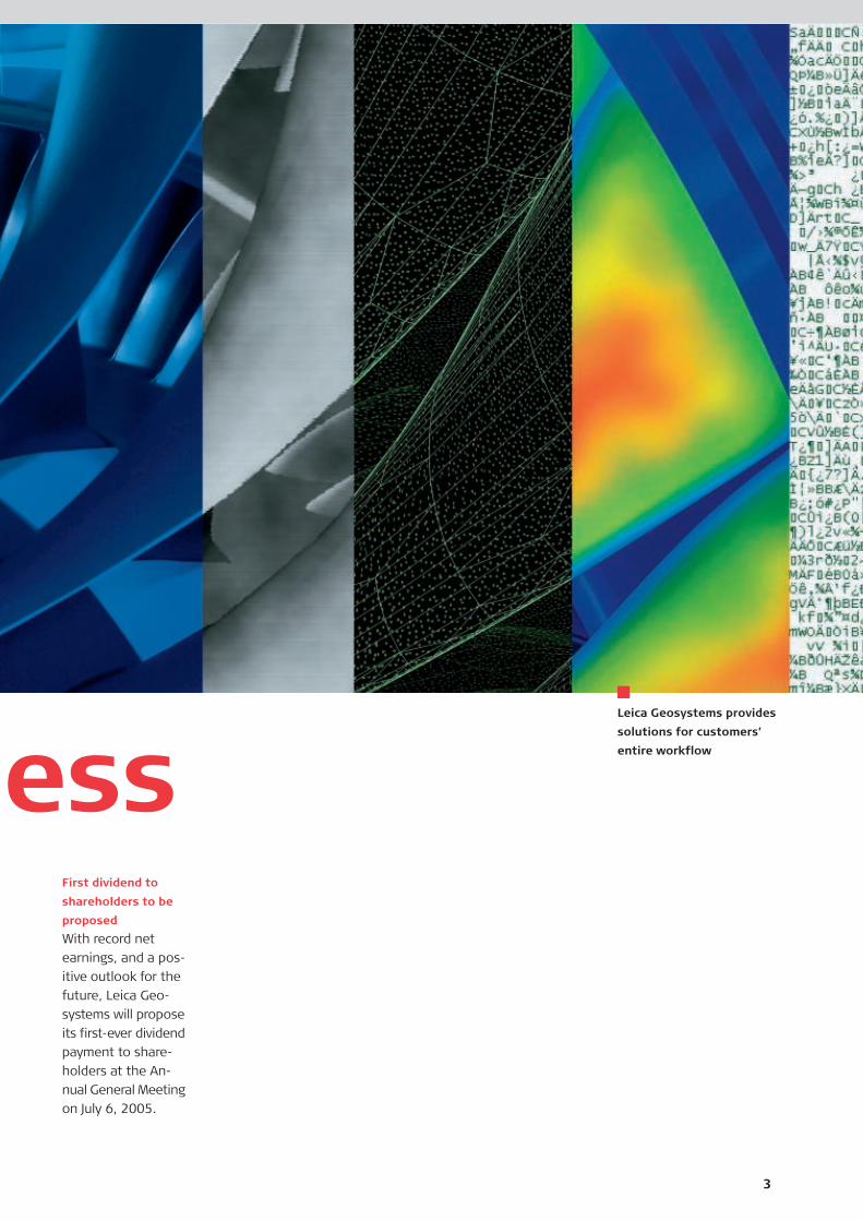
essLeica Geosystems provides
solutions for customers’
entire workflow
3
4Leica GeosystemsAnnual Report
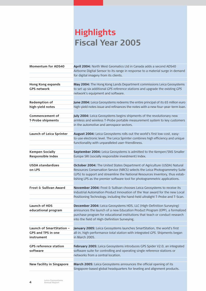
Highlights Fiscal Year 2005
Momentum for ADS40
Hong Kong expands GPS network
Redemption of high-yield notes
Commencement of T-Probe shipments
Launch of Leica Sprinter
Kempen Socially Responsible Index
USDA standardizes on LPS
Frost & Sullivan Award
Launch of HDS educational program
Launch of SmartStation –GPS and TPS in oneinstrument
GPS reference stationsoftware
New facility in Singapore
April 2004: North West Geomatics Ltd in Canada adds a second ADS40
Airborne Digital Sensor to its range in response to a material surge in demand
for digital imagery from its clients.
May 2004: The Hong Kong Lands Department commissions Leica Geosystems
to set up six additional GPS reference stations and upgrade the existing GPS
network’s equipment and software.
June 2004: Leica Geosystems redeems the entire principal of its 65 million euro
high-yield notes issue and refinances the notes with a new four-year-term loan.
July 2004: Leica Geosystems begins shipments of the revolutionary new
armless and wireless T-Probe portable measurement system to key customers
in the automotive and aerospace sectors.
August 2004: Leica Geosystems rolls out the world’s first low-cost, easy-
to-use electronic level. The Leica Sprinter combines high efficiency and unique
functionality with unparalleled user-friendliness.
September 2004: Leica Geosystems is admitted to the Kempen/SNS Smaller
Europe SRI (socially responsible investment) Index.
October 2004: The United States Department of Agriculture (USDA) Natural
Resources Conservation Service (NRCS) selects the Leica Photogrammetry Suite
(LPS) to support and streamline the National Resources Inventory, thus estab-
lishing LPS as the premier software tool for photogrammetric applications.
November 2004: Frost & Sullivan chooses Leica Geosystems to receive its
Industrial Automation Product Innovation of the Year award for the new Local
Positioning Technology, including the hand-held ultralight T-Probe and T-Scan.
December 2004: Leica Geosystems HDS, LLC (High-Definition Surveying)
announces the launch of a new Education Product Program (EPP), a formalized
purchase program for educational institutions that teach or conduct research
into the field of High-Definition Surveying.
January 2005: Leica Geosystems launches SmartStation, the world’s first
all-in, high-performance total station with integrated GPS. Shipments began
in March 2005.
February 2005: Leica Geosystems introduces GPS Spider V2.0, an integrated
software suite for controlling and operating single reference stations or
networks from a central location.
March 2005: Leica Geosystems announces the official opening of its
Singapore-based global headquarters for leveling and alignment products.

5A Year of Success
Who We Are and What We Do
Leica Geosystems – when it has to be right People who build houses or bridges, make maps
and design aircraft need measurements they can
rely on. With almost 200 years’ experience in
pioneering solutions to measure the world, Leica
Geosystems is best known for a broad range of
products that capture and analyze spatial data
easily and accurately, generate models quickly,
and are capable of presenting spatial information
in 3-D. People who use our products every day
trust them for their dependability, the value they
deliver, and our superior customer support.
Taking cutting-edge solutions to the worldBased in Heerbrugg, Switzerland, Leica Geo-
systems is a genuinely global company, with
tens of thousands of customers supported
by more than 2,300 employees in 21 countries
and hundreds of partners located in more than
120 countries around the world. In the course
of its history, Leica Geosystems has grown from
modest origins into the world’s leader in sur-
veying innovation.
Pushing forward the barriers with total solutionsLeica Geosystems is a total-solution provider,
working to supply our customers with systems
that address their needs precisely,
all the way through from presale
advisory services to after-sales
support. Many of our solutions
feature cutting-edge approaches,
such as digital imaging and laser
scanning, but whatever the technology, they are
ultimately designed to enable our customers
to do their jobs faster and more efficiently than
before.
The leading position we hold in our industry is
based on a solid foundation of qualities which,
taken together, give us a unique position in the
world of geospatial systems. These are:
Service: We deliver outstanding service where
and when it matters. Our customers trust us
to keep their equipment up and running at all
times.
Innovation: We have a long history of firsts,
including the theodolite, the aerial camera
and the world’s first total station with inte-
grated GPS – the SmartStation.
Precision and accuracy: We lead the field
in facilitating the capture of precise spatial
information that can be measured repeatedly
and consistently to specification.
Broad solution range: We offer the widest
choice of solutions for high-precision data
capture, fast modeling, easy analysis, and full
3-D visualization and presentation of spatial
information.
Reputation: The Leica brand is synonymous
with high precision, excellent quality and re-
liability, as well as first-class customer service
and organization.
Quality: Leica Geosystems products are
renowned for their dependability in the field.
Product applicationsLeica Geosystems products and solutions are
widely used in:
Surveying, engineering and construction
Civil and structural engineering
Public and private infrastructure projects
Asset and facilities management
Aerospace, automotive and general industries
Mining and exploration
Agriculture and forestry
Mapping
Urban planning and cadastral applications
Disaster management
Our solutions in actionSome of the more impressive examples of our
solutions in action include:
The use of Leica Geosystems’ equipment and
software solutions in the planning and con-
struction of the world’s highest bridge in the
south of France.
Quality control during the construction of
NASA’s space station, the Airbus A380 and
Renault’s F1 racing car, provided by Leica
Geosystems’ laser trackers and photogram-
metry.
The use of Leica Geosystems’ GPS technology,
photogrammetry, total stations and machine
guidance systems to ensure completion of
Hong Kong’s Chek Lap Kok Airport in record
time.
We give our cus-
tomers the tools
they need to do the
job quickly, precisely
and reliably.

6Leica GeosystemsAnnual Report
Letter toShareholders
When it has to be right. This simple phrase is
packed with relevance for our company. At the
heart of the statement is trust; trust in Leica
Geosystems by our customers, employees, busi-
ness and community partners, and investors.
When it has to be right also means commitment.
Commitment to providing our customers with
the right products, services and solutions, so
they can succeed in critical missions, meet tight
schedules and enhance productivity. In this year’s
Annual Report, we will highlight key elements
of this commitment, ranging from product inno-
vation through to our customer care program.
A record yearThe financial success of this year, a record
achievement in many respects, was made possi-
ble by the careful groundwork laid several years
before. With significant investments in research
and development, we now offer one of the most
comprehensive baskets of products and solutions
in our industry. In our current portfolio, customers
have the choice of solutions that span the geo-
spatial imaging chain – from sensors that capture
data in varying degrees of density, through
to software solutions and service offerings that
enable customers to work with up to terabytes
of spatial data.
During the year, we again launched many new
products onto the market, including the Smart-
Station in March 2005. The SmartStation is a
milestone in the surveying industry, and is an
extension of our successful System 1200 family,
which was a material contributor to our business
growth this year. Other products include the
new Local Positioning Technology products from
Metrology, an expanded offering of construction-
oriented products, GPS reference station soft-
ware, and new machine automation solutions,
particularly in the mining sector.
Expanding our customer baseWe continued to gain the trust of many new
customers during the year. This is evidenced by
local-currency growth in several of our businesses
at multiples of historical market growth rates.
In Surveying & Engineering, growth in our high-
end TPS and GPS businesses was particularly
strong, further supported by solid demand for
our low-cost leveling and alignment products.
Our move of the leveling and alignment business
unit to a new facility in Singapore should enable
us to make deeper inroads in Asia, a key growth
region for Leica Geosystems.
Geographically, we continue to hold a leading
market position in Europe, where we recorded
sales growth of 10% this year. We see further
opportunities in Europe, particularly in the
emerging markets of the east, which will com-
plement our solid presence in Western Europe.
Our strongest growth regions this year, however,
were the Americas and Asia Pacific, where we
realized top-line growth rates approaching 30%
in local currency. Growth in these regions was
bolstered by a combination of a strong product
offering and intense marketing initiatives. Apart
from this, new organizational structures added
the local management expertise needed in these
markets. We expect to see continued strong
growth in both regions in the upcoming year.
Our expanding presence in China, led by a dedi-
cated member of management reporting to the
CEO, underscores our commitment to this region.
Outstanding sustainability ratingsResponsible corporate citizenship is part of an
ensemble of values held by Leica Geosystems.
In last year’s Annual Report, we presented our
first comprehensive Corporate Responsibility re-
port. We plan to prepare such a report once every
two years, with an update in alternate years.
In this year’s Annual Report, an update year, we
present several interesting examples of how so-
lutions from Leica Geosystems contribute to our
global sustainability efforts. We also summarize
achievements and opportunities in this area.
We are pleased to report that many international
rating organizations with a focus on sustainable
business practices awarded Leica Geosystems
ratings above our industry average this year, and
numerous sustainable investment funds have
now included our shares in their investment port-
folios.

7A Year of Success
Heerbrugg, June 9, 2005
Mr. Mario Fontana Mr. Hans HessChairman of the President and
Board of Directors Chief Executive Officer
Strong results lead to first dividendSuccess in our markets this year led to a record
financial result. Sales in Swiss francs were CHF
773.2 million, a growth of 12.2% in Swiss francs,
and 15.5% in local currencies. Growth in the
top line as well as the gross margin gave us the
means to make additional investments in re-
search and development and product-marketing
programs, and still increase our earnings by a
multiple of the growth in sales. Our EBITDA
margin increased to 16.6% of sales, and our ad-
justed EBITDA (which removes capitalized R&D
expenditures) rose to 13.2%. The positive ben-
efits of no goodwill amortization, falling debt
levels, lower interest rates, and a beneficial tax
structure supported the growth in operational
earnings, giving rise to net income of CHF 50.6
million, the highest level in our company’s
history.
With this performance, and our growth expec-
tations for the future, we will propose to pay the
first dividend to shareholders since the initial
public offering in 2000 of CHF 4 per share. This
proposal will be put forward to shareholders
at the Annual General Meeting on July 6, 2005.
Solid outlook for 2006Looking ahead to fiscal year 2006, we expect to
have another solid year of sales growth. Earn-
ings should also continue to grow above the rate
of sales.
In closing, we would like to thank all of our stake-
holders for your continued interest in Leica
Geosystems. We look forward to another exciting
year and know that when it has to be right, you
will place your trust in Leica Geosystems.

8Leica GeosystemsAnnual Report
Our Mission and Values
Mission
When it has to be right, customers can
trust Leica Geosystems to provide innova-
tive solutions and services for the capture,
modeling and visualization of 3-D spatial
information.
Values
Our company is guided by the six funda-
mental values that comprise our Code of
Conduct.
Customer orientation
Commitment to quality
Open and constructive communication
Integrity and trust
Innovation
Entrepreneurial spirit
These values are intrinsic to our daily
activities and reflected in the way we:
Serve our customers
Produce and deliver our products
Communicate internally and externally
Remain responsive and competitive
through innovation
Strive to maintain our entrepreneurial
spirit as we grow, and lastly
Conduct ourselves as suppliers, employ-
ees, and corporate citizens
Leica Geosystems can justly claim to be a global
company. Apart from the international scale
of our operations, the Corporate Management
Team is made up of individuals of diverse national
origins, which guarantees a cosmopolitan,
interdisciplinary approach to our business. The
Corporate Management Team, comprising four
corporate officers and five divisional presidents,
hails from Europe, Asia and the Americas — not
coincidentally the most strategically important
regions for the company’s operations.
Technical degrees are the most common aca-
demic background in the team. Three members
of the team hold advanced engineering degrees,
as well as one doctorate in Astronomy. The
remaining members hold degrees in Human Re-
ExperiencedLeadership
Corporate Management
From left to right:
Eric Poll, Corporate VP Strategic Marketing,
Walter Mittelholzer, President Metrology
division, Aad van Vliet, Chief Human Resources
Officer, Klaus Brammertz, President Consumer
Products division, Christian Leu, Chief Finan-
cial Officer, Erwin Frei, President HDS division
(resigned as of May 10, 2005), Hans Hess,President and Chief Executive Officer,
Robert Morris, President GIS & Mapping divi-
sion, Clement Woon, President Surveying &
Engineering division

9A Year of Success
sources, Finance and Business Administration,
Social Science and Forestry. Four individuals on
the team have MBAs.
The industrial experience of the team comple-
ments their varied educational backgrounds.
Several members of the team have spent a sig-
nificant amount of their professional careers
in our industry. Complimenting those with direct
industry experience, other team members con-
tribute their experience in the consumer products,
pharmaceutical, chemical and computer indus-
tries. During their respective careers, members
of Corporate Management have worked in a
broad array of disciplines, gaining experience in
product development, product management,
in-field surveying and mapping, corporate fi-
nance, business development, marketing and
sales, and human resources.
The Corporate Management Team, whose mem-
bers have been with the company for an average
of 10 years, has jointly seen Leica Geosystems
through the challenges and accomplishments
of the recent past. The team, together with the
Board of Directors, has been responsible for
achieving a successful turnaround in our opera-
tions over the past few years.
Corporate Management is assisted in its work
by the 120 members of Senior Management, who
are located in 21 countries around the world.

10
TheWay ForwaLeveling and Align-
ment unit gets new
home in Singapore
Leica Geosystems
opened a new
facility in Singapore
where it will head-
quarter its Leveling
and Alignment
business unit, part
of the Surveying &
Engineering division.
Innovation has a
tradition at Leica
Geosystems
Leica Geosystems
is synonymous with
Swiss precision,
quality and reliability,
but it also stands
for considerable
innovative power.
The SmartStation is
a perfect example.
Spatial information
goes digital
Today, Leica Geo-
systems enables
spatial information
to be captured,
stored and accessed
in digital form, thus
catching the interest
of many exciting
new partners.

11
rdStreamlining
our customers’
workflow
Leica Geosystems
offers scaleable, cus-
tomizable solutions
that enable custom-
ers to automate
processes through-
out the Geospatial
Imaging Chain and
thereby improve
overall efficiency.
Customer care
initiative is king
Leica Geosystems’
customer care ini-
tiative gets off the
ground this year,
leveraging the com-
pany’s reputation
for outstanding
customer service to
further increase
customer loyalty in
the future.
Leica Geosystems’ solutions
transform reality into geo-
metrically accurate drawings
12Leica GeosystemsAnnual Report
The Road Ahead
The spatial information industry is attractive and
dynamic. It provides individuals, enterprises and
governments with information about objects; it
tells us where and what they are, how they look
and when they change. Spatial information is
no longer the exclusive domain of professionals,
such as surveyors, engineers and city planners.
Many of us use it everyday in our car navigation
systems or for location-based services. The
increasing use of spatial information in an ex-
panding array of applications is what makes our
business so exciting. And Leica Geosystems is
equipped to play a major role.
The changing face of our marketSo, what are the trends that will fundamentally
change our industry? One of them is increasing
digitization. The confinement of spatial infor-
mation to maps and plans is history.
Today, this information is required
in digital form, so that it can be
stored in databases, processed and
shared over the Internet. This, in
turn, makes it available for many
new applications, and is one of
the reasons why new players such
as Google, Microsoft, Oracle and other large IT
companies have entered the industry. Leica Geo-
systems is working with many of these com-
panies and, again, is well positioned to explore
the potential of this new digital world.
Another salient feature of today’s industry is
the burgeoning need for spatial information that
is accurate and up to date. For today’s consumer,
the idea of using an obsolete map in a navigation
system is unthinkable. Leica Geosystems’ GPS
technologies can pinpoint any position on the
surface of the earth to an accuracy of a centi-
meter, while the company’s laser technologies
can determine the height of a building with milli-
meter accuracy in seconds.
However, perhaps the most exciting development
in our industry is the trend toward the fourth
dimension. Consumers increasingly expect 3-D
spatial information, preferring it to complicated
2-D maps and plans. Apart from an object’s
location and appearance, many users now need
to understand how it changes over time: in other
words, the fourth dimension. Private and pub-
lic enterprises have a real interest in knowing
whether the structure of a tunnel or a dam has
changed and if it is still safe. Or understanding
the development of cities and villages and their
impact on the environment. Leica Geosystems
offers the solutions needed for these tasks.
Our strategy for shareholder valueLeica Geosystems creates value for its share-
holders through profitable internal and external
growth. However, apart from continuing to offer
the widest range of technologies in the industry
for capturing spatial reality, Leica Geosystems
is now increasingly supplying state-of-the-art
software to process and model this information-
rich data. Leica Geosystems already supplies
solutions for applications such as building infra-
structure (roads, railroads, tunnels, bridges and
houses) as well as other key segments in land
surveying, architecture, mapping, and mining. As
we expand in these areas, the role of software
will be increasingly important.
Strategic partnerships, too, will be essential if
we are to offer attractive solutions for entire
workflows of targeted segments. In the future,
we will continue to focus on promising market
segments and dynamic geographic regions that
offer profitable, above-average growth. At the
same time, we will continue to offer a wide variety
of distinctive, customer-oriented services on a
global basis.
Leica Geosystems is in an excellent position to
capitalize on the emerging trends in our industry.
The opportunities are compelling, but require
focus to be effective. Our strategy is a measured
one, which leverages the strength of our existing
portfolio of sensors and software solutions,
as well as strategic partnerships and selected
acquisitions, to develop and expand into new
vertical market segments and service offerings.
The increasing use
of digital informa-
tion has transformed
the face of the
industry and eman-
cipated more and
more users.

13The Way Forward
After 34 years in the city state, Leica Geosys-
tems AG finally established a company-owned
operation in Singapore. Its name:
Leica Geosystems Technologies Pte
Ltd. Prior to this, Leica Geosystems
and Leica Microsystems (based
in Wetzlar, Germany) held a 50/50
interest in a business that Leica
Geosystems has now sold off. Leica
Geosystems Technologies is part of the Survey-
ing & Engineering division, which in turn belongs
to Leica Geosystems AG.
Key activitiesDuring the second half of calendar 2004, the
Surveying & Engineering division was subdivided
into four business units, and the Leveling and
Alignment unit set up in Singapore. Leveling
and Alignment is responsible for the running of
Leica Geosystems Technologies in Singapore
and maintains a research and development unit
in Grand Rapids, Michigan, USA. The new com-
Leica GeosystemsTechnologies Pte Ltd:A Company-Owned Base in Singapore
pany’s range of operations will have a wide-
reaching scope. These include its functions as:
The main competence center for research and
development into digital and optical leveling
and laser products
The global headquarters for product engineer-
ing and design
A global base for driving worldwide sales
together with the marketing of digital and
optical leveling and laser products
The main assembly plant for leveling and
alignment products, such as optical levels,
digital levels, rotating lasers and pipe lasers
An assembly plant for other surveying and
engineering products, including Terrestrial
Positioning Systems (TPS) and accessories
A main sourcing center for the Surveying &
Engineering division’s activities in Asia
A logistics center for the management of
worldwide distribution and the customization
of products manufactured in Singapore
Plant and productsThe new facility covers a total area of 50,000
sq. ft. and is located at Singapore’s Woodlands
East Industrial Estate, headquarters for the
Asia Pacific operations of many multinationals.
The cost of setting up the plant ran to some
SGD 6 million, with an additional SGD 6 million
planned for research and development each
year. This business unit currently employs some
150 people worldwide, with over 100 of them
based in Singapore. There are plans to ramp up
the Singapore workforce to 140 over the next
two years.
Since going onstream, Leica Geosystems Tech-
nologies in Singapore has developed, engineered
and manufactured a number of exciting and
innovative products for the global market, one
of the more notable being the Leica Sprinter,
holder of numerous patents and the world’s first
affordable and easy-to-use electronic level. The
Singapore operation is backed up by the Re-
search and Development Unit in Grand Rapids,
Michigan, USA. This unit recently developed the
Leica Rugby 300 SG Grade Laser and the Rugby
400 DG Dual Grade Laser, both of which are
used primarily in the construction industry and
manufactured at the new facility in Singapore.
Leica Geosystems Technologies Pte Ltd, Singapore,
officially opened its doors on March 31, 2005
From its Singapore
base, Leica Geo-
systems Technolo-
gies is ideally placed
to serve the Asia
Pacific region.
14Leica GeosystemsAnnual Report
Leadershipthrough Innovation
The technologies and the competence to get it rightLeica Geosystems has a clearly defined mission:
to be the world’s leading provider of innovative
solutions for capturing, modeling, analyzing and
visualizing spatial data. Strategic acquisitions
and continuous product development have created
a comprehensive technology and product port-
folio that gives our company a unique position
in our industry.
Over the years, the company has developed
a number of technologies and software appli-
cations that are now core to our products and
solutions. These include, among
others, EDM (Electronic Distance
Measurement), high-precision angle
measurement, GPS technology,
3-D laser scanning and point-cloud
analysis. Far-reaching software
expertise, coupled with extensive
research and development, are es-
sential if the company is to continue generating
innovative, market-leading products.
Leica Geosystems’ innovation efforts aim at one
single goal: to understand and support customer
workflow. This has resulted in a product portfolio,
a service offering and a comprehensive range of
solution packages that are unique to the market.
An industry pioneer: where innovation has a tradition Leica Geosystems is synonymous with Swiss
precision, quality and reliability; but it also stands
for considerable innovative power.
Our corporate culture is defined by innovation
and a constant focus on increasing customers’
productivity. Contributing towards this are some
of the world’s most highly qualified specialists
and multidisciplinary engineers. A core team of
experts at our Corporate Technology Center in
Heerbrugg fosters and supervises cross-divisional
developments. We also conduct focused research
and development activities in other locations,
the United States, Singapore and Australia. Our
multidisciplinary and multinational R&D team
includes mathematicians, physicists, and geo-
scientists. The company also cultivates a long-
standing relationship with the Swiss Federal
Institute of Technology as well as many other
research centers around the world.
Leica Geosystems holds more than 1,000 pat-
ents and has a full product pipeline. The number
of innovations is at an all-time high, demonstrat-
ed by the fact that 50% of our current year’s
revenue was generated by products less than a
year old.
Leica Geosystems has consistently been at the
forefront of technological development in our
industry. Our development efforts are focused on
improving productivity: whether it is enhancing
the speed, quality and precision of instruments
to increase surveying effectiveness, leveraging
new technologies to capture and analyze larger
amounts of spatial information, or devising ways
of handling large quantities of spatial data effec-
tively. In the 1980s, the use of lasers made its
way into the industry. In the 1990s it was GPS.
More recently, laser scanning appeared on the
scene. The latest developments include the move
to the fourth dimension and the digitization of
geographic information.
The digital revolutionToday’s laser scanners capture and present
accurate, as-built information that can be pro-
cessed instantaneously on a PC. Projects are
completed faster, output is more precise. De-
ferring calculations to a later date is simple and
unproblematic. Three-dimensional
computer models are created in
virtual reality, featuring all the com-
plexities of “the real thing.” They
are comprehensively tested in
simulations, before anyone even
reaches for a tool. Computer modeling creates
a virtual world that permits developers to move
at will within the model and subject it to com-
prehensive testing and simulation.
Creating simulations that show how well a
building will blend into its environment, how an
aircraft will perform in flight, how a new city
overpass will affect the flow of traffic or how
At Leica Geosystems,
we have a history
of pushing forward
the boundaries of
science and technol-
ogy for geographical
applications.
Digitization has ex-
pedited and simpli-
fied the development
process like nothing
else before it.

15The Way Forward
Realizing a Dream – the SmartStation
fauna and flora will develop over time: such
tasks, to name just a few examples, are now
easier to perform than ever before.
Point-cloud generation, aerial photographs,
simulations and similar applications in the digital
realm represent terabytes of data. Leica Geo-
systems is changing to meet its customers’ needs
as more and more clients demand all-inclusive
hardware, software and services solutions.
Today, some 80% of our company’s turnover
comes from equipment sales. However, it is
estimated that in the next few years, software
and related services will account for up to 35%
of sales. The company is moving in that direc-
tion even now with products like Cyclone, the
point-cloud process and data management soft-
ware, the Leica Photogrammetry Suite for geo-
spatial imaging and SpiderNET, the GPS network
controller. The software required to process
large amounts of data is created in cooperation
with data storage and database specialists,
such as Oracle.
Brisbane Machine Automation Business
Leica Geosystems’ investments in the Asia Pacific
region included a move to new premises at
Dutton Park, Brisbane, Australia, in March 2005.
Following the acquisition of Tritronics and the
expansion of activities for machine automation
and site-monitoring systems for mining and
construction, existing facilities were no longer
adequate. The move has also provided an op-
portunity for Australia-based sales and support
personnel who work for other divisions or oper-
ating units of Leica Geosystems to be colocated.
The new premises provide a stimulating environ-
ment for R&D projects in mine and construction
machine automation systems, as well as a de-
monstration and training center for a wider range
of Leica Geosystems products.
Making the SmartStation concept
a reality was a long-time dream for Dr. Craig Hill,
who began a doctorate in 1993 focusing on the
integration of GPS and TPS technologies in a single
instrument. Dr. Hill believes the new development,
which is simple to use and provides an affordable
entry point to RTK GPS technology, will materially
improve surveyors’ efficiency.
SmartStation represents a significant opportunity
to encourage the use of RTK GPS by professionals
who until now have avoided the technology. Fur-
thermore, SmartStation ensures that the System
1200 family holds an unequalled market position
because TPS1200 is the only total station incorpo-
rating GPS technology. This unique feature, coupled
with TPS1200’s many other leading attributes,
should continue to be a compelling reason for ex-
isting, as well as new, customers to choose Leica
Geosystems’ surveying instruments.
For Dr. Hill, who was honored to play a key role in
the development of SmartStation, completion of the
project meant that a long-held vision had finally
become a reality.
Dr. Craig Hill, Director of
Survey Applications,
Business Unit Surveying

reference the image to obtain accurate coordi-
nates, measure it to extract specific data, analyze
the data to discover relationships between image
features, and present the data in a format that
will enable good decision making. In the industry,
we call this workflow the Geospatial-Imaging
Chain.
Empowering customers for greater independenceThere used to be a significant gap between sur-
veying and mapping, but in recent years, this has
become noticeably smaller. Leica Geosystems
is working to create products that fuse technol-
ogies from different disciplines within the geo-
spatial industry and achieve data interoperability.
Such products empower customers to execute
processes themselves which they have tradition-
ally outsourced and enable different systems
to share information. The emergence of products
that service all the links within the Geospatial-
Imaging Chain is significantly bridging the gap
between disciplines and, at the same time, sim-
plifying workflows.
While the use of geospatial information has
grown organically in enterprise environments,
there is always a risk of hindrances to pro-
ductivity, as organizations find themselves in a
juggling act, trying to figure out how
to share data. Data interoperability
is a necessity in all project workflows
that employ more than one hard-
ware or software solution. If we are
to streamline production, we need
to integrate workflows and achieve data inter-
operability between systems. Only by doing this
can we push production to its highest attain-
able level while maintaining the necessary high
standards of accuracy.
Boosting efficiency and decision makingTo streamline the geospatial-imaging workflow,
organizations can take advantage of Leica Geo-
systems’ scaleable, customizable imaging and
software solutions. These tools automate the
Geospatial-Imaging Chain from beginning to end,
with the result that projects can be completed
more efficiently and cost-effectively, and with
higher precision. The ensuing improvement
in workflow furnishes decision makers with the
information they need to reach decisions more
quickly and accurately, and makes a significant
contribution to overall project success.
UnderstandingCustomers’Needs
Although different organizations make use of
geospatial information in many different ways,
as determined by their own specific needs, their
ultimate objective is always the same: to have
the data required to make better-
informed decisions. In order to fa-
cilitate the decision-making process,
some users need maps or topo-
graphical models, while for others
the ideal solution is a fly-through,
3-D scene. And although the crea-
tion of these products and services is driven
by a wide variety of needs, the genesis of each
and every one is the same: geospatial imaging.
A clear relationship exists between the many
individual activities that constitute a project,
from data capture, spatial referencing, measuring
and analysis through to presentation. Ideally,
each step will flow smoothly into the next. Each
component in the process should likewise blend
seamlessly with the others in pursuit of the pro-
ject’s objectives: to capture the required image,
16Leica GeosystemsAnnual Report
Wendy Watson, Vice President
of Product Management & Mar-
keting, GIS & Mapping division
By bringing different
disciplines closer
together, we are
giving customers
more freedom.
Geospatial imaging
describes our
customers’ work-
flow and defines
our approach to the
industry.

17The Way Forward
The Customer Care Program
Dave Koster, Vice President of Customer
Support and Service, Metrology division
in new ideas. And there’s been a general in-
crease in awareness within the company of the
importance of customer care.
How do Leica Geosystems customers notice the difference?Next to customer care products that really fit
our customers’ needs, and the faster service we
provide, the general attitude towards service
has received more attention in various parts of
our company. The way we answer the phone
or how we offer assistance makes all the differ-
ence. Whenever we overachieve our customers’
expectations, their loyalty will increase. That’s
a basic mindset, and we’re working on making
this even better.
What else do you have in the pipeline?The next step is to standardize the look and feel
of our customer care, so whether the customer
owns a DISTO™, a GPS instrument or an HDS
scanner, the service contracts, support calls and
invoices are always the same. We’re also look-
ing at further improvement of our customer ser-
vices, making them as convenient as possible.
By giving our customers the after-sales care they
deserve, we believe we can really make a differ-
ence!
Leica Geosystems recently launched a Customer
Care Initiative. In the interview below, Dave
Koster, Vice President of Customer Support and
Service of the Metrology division, explains what
the project is all about and provides a rundown
of progress so far.
What is the aim of the Customer CareInitiative?Dave Koster: Mainly to increase customer loyalty
by boosting after-sales satisfaction. If we can
help our customers get the most out of the in-
struments they buy from us over the product’s
entire life cycle, they will be more loyal. That in
turn helps us to grow and stand out in today’s
markets. We see it as a major opportunity.
Who is involved in the program?It’s a corporate project involving service and
support managers from various divisions as well
as a controller and a human resources con-
sultant. But the drive to get things done comes
from the divisions. Ultimately, everyone will
play a part.
What are the key elements of the customer care program?We are targeting our efforts on six key areas:
Defining a clear after-sales strategy valid
across the entire company.
Strengthening service and support manage-
ment in the various divisions.
Creating a clearly defined, comprehensive
service and support portfolio.
Benefiting from information and knowledge
management internally and with key or con-
tract customers.
Further expanding the possibilities of remote
access services.
Finally, developing ideas to enhance cus-
tomers’ productivity using our applications
expertise.
Can you tell us how the project has been progressing?We make much better use of synergies between
regions and divisions, and have employed a
number of customer care professionals to bring

18Leica GeosystemsAnnual Report
Customer Needs andSatisfaction Survey 2004
The customers and noncustomer groups that
participated in the survey included civil structural-
engineering surveyors, cadastral surveyors, land
surveyors, aerospace and automotive manufac-
turers, industrial measurement, GIS and spatial-
mapping specialists, mining and exploration,
education institutions and universities, research
organizations and architects, builders and real-
estate professionals.
As in the 2002 survey, Leica Geosystems’ per-
formance in the last two years generally remains
ahead of the average for the competition. We
recorded a very high KPI score which measured
our performance against 15 attributes relating
to customer needs. Leica Geosystems generally
performs well on the attributes regarded as most
important in driving customers’ overall satisfac-
tion. We maintain a competitive position on the
four most important attributes – reliable products,
high-quality technical support, responsiveness
to requests and prompt provision of repairs/
replacements. We will continue to do every-
thing in our power to meet the needs of our
customers.
Our customers are generally very satisfied with
our performance. On average, Leica Geosystems
recorded a high score for overall satisfaction.
Similarly, our customers are also very loyal to us,
demonstrating generally very high levels of in-
tention to repurchase from us in the future and
a strong willingness to recommend us to profes-
sional colleagues. Our brand name continues to
be very well respected and a core asset to the
company with a very strong brand quality rating.
The results of the survey will help us to build on
our success, to differentiate ourselves from our
competitors and to address those areas where
we need to improve. They will be incorporated
into the development of strategic business,
product, marketing and communication plans.
1 Survey fieldwork was conducted by two independent market researchcompanies on behalf of Leica Geosystems. Fieldwork was conductedbetween October 2004 and January 2005. Twenty-three survey inter-views were conducted face-to-face, and 911 by phone. An additional95 surveys with Leica Geosystems employees were self-completedvia email. Leica Geosystems customers were informed that Leica Geo-systems was the survey sponsor before giving their answers. Non-customers were informed at the end of the survey. Data provided byrespondents requesting anonymity remained completely confidential.The total sample was provided by Leica Geosystems and the surveydata were analyzed for Leica Geosystems’ proprietary use.
2 Approximately 70% of those interviewed used Leica Geosystemsproducts.
3 Approximately 30% of all interviews were conducted with those whodo not use any products from Leica Geosystems.
Since 1995, Leica Geosystems has been con-
ducting customer-based research to help us to
understand and appreciate customer needs and
perceptions and to evaluate our performance.
The research also involves noncustomers and
employees. The survey provides
insight into the key issues our
customers and noncustomers face
when selecting a supplier in our
industry. It also assists us in under-
standing what their perceptions are
of Leica Geosystems as a supplier, their levels
of satisfaction and what is important to them.
In addition, the survey provides a basis in which
we can measure our own performance against
that of our competitors.
In January 2005, we completed the latest survey1,
which researched customers’2, noncustomers’3
and employees’ perceptions on satisfaction,
brand quality and supplier performance. In total,
1,029 interviews were completed across five
countries in Europe, Asia and America and five
key divisions of Leica Geosystems.
The results will help
us build on our suc-
cess and differen-
tiate ourselves from
our competitors.
Performance on three key measures
Leica Geosystems All competition average
9
8
7
6
5
4
3
2
1
0
Likelihoodto repurchase
Likelihoodto recommend
Overallsatisfaction
8.0
7.5
8.1
7.3
8.1
7.2

19The Way Forward
“Leica Geosystems is committed to focusing the
organizational structure, its processes, daily
activities and ideas towards achieving customer
satisfaction and meeting customer expectations.”
This statement, taken from our corporate qual-
ity policy, is no empty phrase. In the past fiscal
year, we streamlined many of our
operational processes and lever-
aged various synergies. In addition,
several of our organizations outside
Switzerland were ISO-9001:2000-
certified under SQS (the Swiss As-
sociation for Quality and Management Systems),
or are well on the way towards receiving certifi-
cation.
Progress made with the improvement of product
quality and reliability was likewise very satisfac-
tory. New products and prototypes are regularly
reviewed, even at the early stages of develop-
ment, which has enabled us to reduce time to
market and achieve a high first-pass yield in the
series manufacture. This means individuals in
R&D or process engineering do not waste their
talents on troubleshooting and can use them
more productively developing innovative new
products.
Suppliers and partners can also have a major
influence on the quality and reliability of our
products. We have a clear-cut evaluation process
and a selection of criteria to help us choose part-
ners who fully meet our requirements for high
quality and reliable products. Internal process
audits and external audits at suppliers’ premises
carried out the previous year provided a clear
indication of the improvements and corrective
action required.
One other key factor in successful quality
management is ongoing employee training. Apart
from ensuring that everyone understands our
quality objectives and benefits from lessons
learned, we use train-the-trainer methods and
integrate new employees as quickly as possible.
All these efforts have helped us in our quest to
boost business excellence at all levels.
Philip Benz is one of the first
links in the Leica Geosystems
quality assurance chain
A Firm Commitment to Quality Assurance
We spare no effort
in our quest to
guarantee quality
at every stage
of the value chain.

20
Changing the
focus of our
responsibilities
Our commitment to
corporate responsi-
bility remains firm,
and has broadened
to include even
greater responsibility
for our employees’
well-being, social
activities and involve-
ment in matters
of public interest.
Making a real
difference
Our products help
to make life safer,
have an important
cultural role to play,
and make a signifi-
cant contribution
towards preserving
the treasures of
nature.
Commitment to the
highest standards of
corporate citizenship
We are untiring in
our commitment to
the highest stan-
dards of responsible
corporate behavior
in how we deal with
our customers, our
partners, our staff
and our investors.
Corporate Res
21
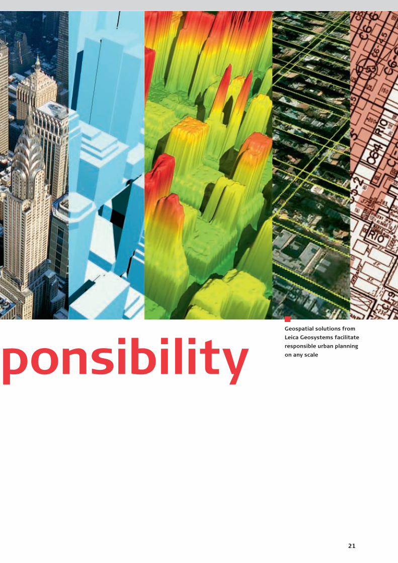
Geospatial solutions from
Leica Geosystems facilitate
responsible urban planning
on any scaleponsibility

22Leica GeosystemsAnnual Report
Statement of Responsibility
will be part of a more general supplier policy
and supported by newly defined environmental,
social and health/safety-related targets.
Apart from making our values and principles
central to everything we do, we believe it is im-
portant for us to communicate our successes
and results to the outside world. We achieve this
by publishing a separate and more detailed re-
port on corporate responsibility every two years.
The next one will appear in 2006.
Sustainability ratingsEncouragingly, our efforts have received well-
above-average marks in sustainability assess-
ments. The Zurich Kantonalbank, for instance,
awarded us an A (on a scale of C to AAA), while
Inrate rated us 11% above the average for our
sector in its ecological rating and 26% above
the average for our sector on social issues. Many
socially responsible funds — including the
Kempen SNS Smaller Europe SRI Index, the first
sustainability index for smaller European com-
panies – now invest in our stock.
Leica Geosystems is acutely aware of its respon-
sibilities towards the environment, society and
future generations. We have a long tradition of
environment-friendly, socially and economically
responsible corporate behavior, and are con-
scious that sustainability is the linchpin of all our
actions. The focus of our efforts shifts continu-
ally in response to environmental, technological,
social and economic change. The
needs and expectations of our
stakeholders likewise reflect these
developments and spur us in our
efforts to find the most responsible ways of
achieving success. Globalization has also expand-
ed our sphere of influence, and today we are
in a position to influence social developments in
emerging markets through our employees and
suppliers abroad.
Over the years, our commitment to sustainable
development has undergone a significant shift.
As in the past, we remain firmly committed
to environmental and economic optimization of
our premises and production processes, but
our concerns have expanded to include greater
responsibility towards our employees, our social
activities and our involvement in matters of
public interest. One example is our appointment
of integration managers to help new employees
settle into their new professional and private
environments. Finally, it is vital that our cus-
tomers, our employees, our suppliers and our
shareholders see the value of buying our in-
struments, of working with us and of investing
in our company.
Top management recently defined future strat-
egy in a review that foresees the introduction
of a more general social policy, incorporating
compliance with human rights, to complement
our existing human resources strategy and code
of conduct. Although the group already observes
these principles, we feel there is a need for
a formal statement to monitor adherence. This
We have a firm
commitment to
all stakeholders.
23Corporate Responsibility
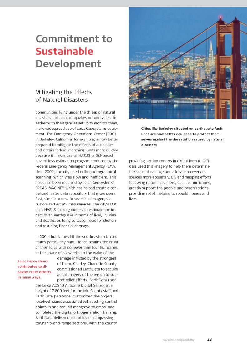
Mitigating the Effects of Natural Disasters
Communities living under the threat of natural
disasters such as earthquakes or hurricanes, to-
gether with the agencies set up to monitor them,
make widespread use of Leica Geosystems equip-
ment. The Emergency Operations Center (EOC)
in Berkeley, California, for example, is now better
prepared to mitigate the effects of a disaster
and obtain federal matching funds more quickly
because it makes use of HAZUS, a GIS-based
hazard loss estimation program produced by the
Federal Emergency Management Agency FEMA.
Until 2002, the city used orthophotographical
scanning, which was slow and inefficient. This
has since been replaced by Leica Geosystems’
ERDAS IMAGINE®, which has helped create a cen-
tralized raster data repository that gives users
fast, simple access to seamless imagery via
customized ArcIMS map services. The city’s EOC
uses HAZUS shaking models to estimate the im-
pact of an earthquake in terms of likely injuries
and deaths, building collapse, need for shelters
and resulting financial damage.
In 2004, hurricanes hit the southeastern United
States particularly hard, Florida bearing the brunt
of their force with no fewer than four hurricanes
in the space of six weeks. In the wake of the
damage inflicted by the strongest
of them, Charley, Charlotte County
commissioned EarthData to acquire
aerial imagery of the region to sup-
port relief efforts. EarthData used
the Leica ADS40 Airborne Digital Sensor at a
height of 7,800 feet for the job. County staff and
EarthData personnel customized the project,
resolved issues associated with setting control
points in and around mangrove swamps, and
completed the digital orthogeneration training.
EarthData delivered orthotiles encompassing
township-and-range sections, with the county
Commitment toSustainableDevelopment
Cities like Berkeley situated on earthquake fault
lines are now better equipped to protect them-
selves against the devastation caused by natural
disasters
providing section corners in digital format. Offi-
cials used this imagery to help them determine
the scale of damage and allocate recovery re-
sources more accurately. GIS and mapping efforts
following natural disasters, such as hurricanes,
greatly support the people and organizations
providing relief, helping to rebuild homes and
lives.
Leica Geosystems
contributes to di-
saster relief efforts
in many ways.

24Leica GeosystemsAnnual Report
Almost one and a half thousand years after its con-
struction in the center of ancient Constantinople,
the great church of Saint Sophia has finally di-
vulged the secret of its ingenious design. Volker
Hoffmann, professor at the Institute of Art His-
tory at the University of Bern, deciphered the
mystery using state-of-the-art HDS™ laser tech-
nology from Leica Geosystems. Some of his
initial laser evaluations were shown for the first
time in July 2004 at the Congress of the Inter-
national Society for Photogrammetry and Remote
Sensing (ISPRS) in Istanbul. In mid-October, the
Leica HDS3000 was used to analyze the build-
ing’s floors. At an early stage of the research
project the handheld Leica DISTO™ laser meter
also played an important role.
Because of its vast dome, which appears to float
weightlessly above the main space below, the
church was widely regarded as the eighth won-
der of the world. The original construction plans
have never been found, and for hundreds of years
experts have tried to fathom out how scientists
and artists working in the sixth century managed
to construct a freely suspended dome almost 56
meters high and 31 meters wide, supported only
by four pillars. Considering the technical facilities
available at the time, many experts consider the
building to be one of the boldest feats of con-
struction ever achieved by human hand.
Now Volker Hoffmann and his assistant, with the
help of the 3-D laser measurement techniques
made possible by Leica Geosystems equip-
ment, have cracked the once insoluble problem
of determining the church’s dimen-
sions with absolute precision and
discovered that its design is based
entirely on an “analemma.” This is
a projection technique described by
Ptolemaeus, which makes it possi-
ble to interconnect the earth and the canopy of
heaven in accordance with the view of the
world at this time: the sphere representing the
sky, god and the church, and the cube repre-
senting the earth with its four directions, above
and below. As Volker Hoffmann explains, “For
the first time ever, the Leica DISTO™ laser mea-
suring instrument enabled us to determine the
precise distances of the four supporting pillars
to within a millimeter at the simple touch of a
button. This was highly important at the start of
our work and helped us calculate the dimensions
of the double circle/double square.” His findings
revealed the brilliance of the design principle be-
hind this magnificent monument to Saint Sophia
and man’s ingenuity, and explain the structure’s
astonishing stability. These will now be pre-
sented at exhibitions in Berlin, Bern, the United
States and France.
Unraveling the Mystery of the“Eighth Wonder of the World”
For almost 1,500 years, Hagia Sophia in Istanbul,
built between 532 and 537 AD, confounded experts
attempting to discover the secret of its design;
now, the conundrum has been solved
Leica Geosystems
equipment helps to
add to the stock of
human knowledge
and understanding.

25Corporate Responsibility
Wolf Survey and Mapping in Canada is a major
supplier of seismic front-end services to energy
exploration and production companies in Canada
and uses GPS systems to support seismic ex-
ploration and surveying applications. Seismic
surveys are used to detect and map different
geological layers below the surface of the earth
and provide invaluable information about under-
ground substructures. Leica Geosystems asked
Operations Supervisor Mark Strickland to explain
some of the complexities of the business and
environmental benefits of using GPS in his work.
Leica Geosystems: What is the use of seismic surveys?Mark Strickland: For geophysicists, seismic
surveys are an indispensable means of prospect-
ing for new oil and gas deposits and enable us
to estimate the size, shape and depth of reser-
voirs as well as their porosity and fluid content.
What do seismic surveys involve and howhave they been conducted in the past?Traditionally, seismic surveying has meant clear-
ing vegetation in the target zone, which in some
cases covers thousands of square kilometers.
The development of alternative survey technol-
ogies – Leica Geosystems GPS for instance –
has enabled us to use less-invasive procedures.
How have these surveys affected the environment?Conventional seismic programs have inevitably
affected environmentally sensitive areas and led
to the destruction of vegetation, habitat, ground
disturbance and the disruption of many natural
phenomena.
How has the use of Leica Geosystems GPS equipment reduced the environmentalimpact of seismic surveying?The obvious benefits of using GPS for seismic
surveys include minimal environmental impact
with reduced timber damage, and a safer, single-
pass operation with fewer exposure hours to
danger. It eliminates the need for a precut sight-
line, and thus the felling of trees, and drasti-
cally reduces the work involved. It is an industrial
revolution in every sense of the term!
Mark Strickland: “Our reasons for choos-
ing the Leica GPS 1230 were its durability,
performance under adverse field condi-
tions, improved user interface and out-
standing battery performance.”
Minimizing the EnvironmentalImpact of Seismic Surveying
The benefits of using GPS for seismic surveys
include minimal environmental impact, safer,
single-pass survey operations, and flexible crew
movements, saving time and money

26Leica GeosystemsAnnual Report
Our environmental footprint is
very small and we aim to keep
it that way
Reducing ourEnvironmentalFootprint
An all-round boost in efficiencyIn the past, we have concentrated on optimizing
production processes, but last year the focus
was on improving our infrastructure and innova-
tion processes. At company headquarters in
Heerbrugg, we demolished a number of old build-
ings to create attractive green recreation areas
for our employees. New unpaved spaces and
parking lots allow vegetation to grow and rain-
water to drain off naturally. Our new facilities in
Singapore feature a new air-cooled air-condition-
ing system that cuts energy consumption by
30% because it can be switched on and off, as
required, in nine different zones. Special sheeting
on the windows reflects 70% of the sun’s heat.
The new system has also reduced water con-
sumption and contamination, and indoor noise
levels.
Sustainable product designTwo students working with “seed sustainability,”
a Swiss Federal Institute of Technology project
based in Zurich, have written theses on the
integration of sustainable product
design into our business processes.
In response to their work, the Leica
Innovation Process (LIP) will be
adapted to encourage sustainable
design and feature performance indicators to
monitor and control improvements, such as re-
cycling quotas.
New environmental goalsManagement has also set several new environ-
mental goals for the next five years. Since we
have largely outsourced basic production process-
es and require few resources for the assembly
of our products, the goals we have set ourselves
are more quality oriented. They include:
A 5% reduction in energy use (electricity and
fossil fuels), relative to sales
Use of environmentally friendly/multipurpose
packaging materials
A reduction of end-of-life waste created by
our products in accordance with national and
international regulations
Environmentally friendly mobility (e.g. using
modern communication technologies, pro-
moting teleworking)
The obligation is
clear: to leave a
world fit for our de-
scendants to live in.
27Corporate Responsibility
SocialCommitment
Corporate social responsibilityLeica Geosystems aspires to be a company in
which employees, customers, investors and part-
ners have complete confidence. Corporate social
responsibility is a means of boosting our image
as a fair and attractive employer because it
increases staff loyalty and attracts well-qualified
professionals. We regularly conduct employee
satisfaction surveys to find potential for improve-
ment. Our last major survey in 2003 was fol-
lowed by a minisurvey in September 2004, which
showed an increase of 15% in satisfaction for
all five areas in question. External rating agen-
cies have also given us very positive evaluations
and provided input as to how we could further
improve.
Work-life balanceIn November 2004, “Familienplattform,” an as-
sociation involving three important Swiss institu-
tions, awarded Leica Geosystems the title of
family-friendly company of the month. We spon-
sor a child-care center, employ a social adviser
for our employees, offer part-time work and an-
nual flextime models and the possibility for tele-
working. More and more employees are making
use of the possibilities of unpaid leave and
sabbaticals. We have also introduced workshops
for managers to analyze their work-life balance
and forestall burnout.
Integration/diversity/equalityAs a global company, we employ people from
many different nationalities. We recently set up
a workshop to explore ways of helping new em-
ployees, particularly those moving
to foreign countries, acclimatize
to their new surroundings. We now
employ integration managers,
whose job is to assist employees to
settle in their new professional and
private environments. Leica Geosystems Technol-
ogies Pte Ltd in Singapore provides overseas
workers with subsidized accommodation for the
first two years of their stay.
We have also introduced round-table meetings
as a forum for the informal exchange of informa-
tion between management and employees. Our
Chief Human Resources Officer is also respon-
sible for ensuring that men and women receive
equal pay for the same work.
Social data and goalsWe now maintain a human resources informa-
tion system, where we collect social data to
monitor achievement of our social, health and
safety goals. On a social level, we are looking to
increase the percentage of part-time and female
employees in top and middle management. We
wish to increase diversity by recruiting people
from various ethnic backgrounds. Our aim is to
employ a large number of apprentices and train-
ees to reduce youth unemployment. Another
goal is to build up a partnership with a charitable
organization for a social development project in
which we can assist with our expertise and prod-
ucts. Next to our introduced and more specific
Code of Conduct, we are introducing a social pol-
icy that defines our adherence to human rights
in a more general way.
We go to great
lengths to improve
our employees’
quality of life and
job satisfaction.
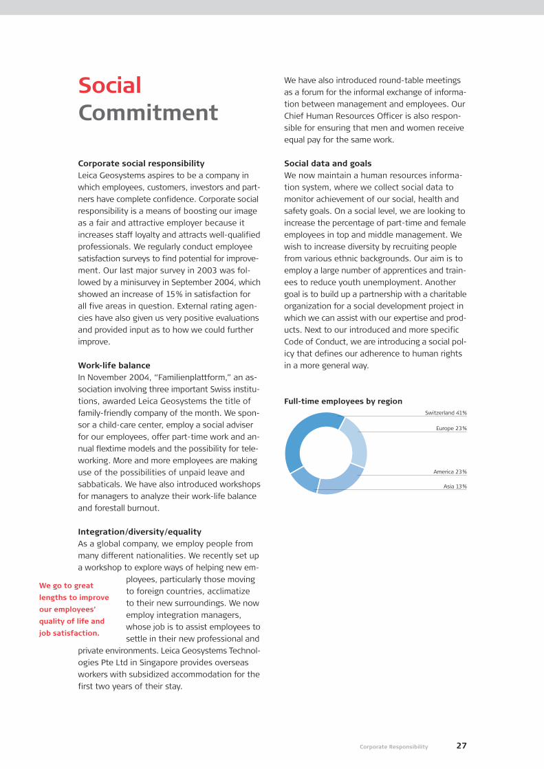
Full-time employees by regionSwitzerland 41%
Europe 23%
America 23%
Asia 13%

28
Laser scanning
comes of age
3-D laser-scanning
solutions from High-
Definition Surveying
broke out of the
early adopter phase
of their life cycle,
resulting in 149%
sales growth in
fiscal year 2005.
Key customer
wins in 2005
Governmental agen-
cies in countries
around the globe
increasingly turned
to GIS & Mapping
geospatial solutions
in fiscal year 2005.
Operating DiviStrong growth
in key regions
Robust demand
for Surveying & En-
gineering products
led to significant
local currency sales
growth in the US
and Asia in fiscal
year 2005.
29
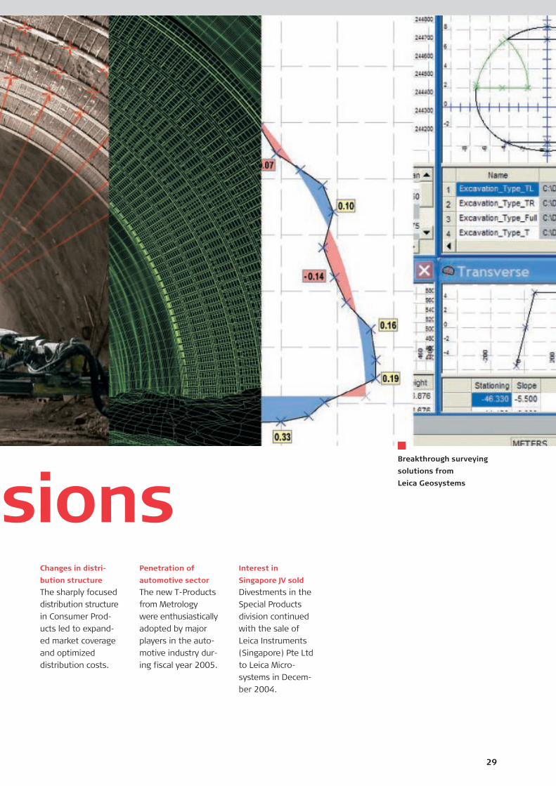
Breakthrough surveying
solutions from
Leica Geosystems
Changes in distri-
bution structure
The sharply focused
distribution structure
in Consumer Prod-
ucts led to expand-
ed market coverage
and optimized
distribution costs.
sionsPenetration of
automotive sector
The new T-Products
from Metrology
were enthusiastically
adopted by major
players in the auto-
motive industry dur-
ing fiscal year 2005.
Interest in
Singapore JV sold
Divestments in the
Special Products
division continued
with the sale of
Leica Instruments
(Singapore) Pte Ltd
to Leica Micro-
systems in Decem-
ber 2004.

Surveying & Engineering
Surveying & Engineering pro-
vides a wide choice of products
and services that include TPS
total stations, GPS Surveying
Systems, levels, construction-
site lasers, and machine guid-
ance systems, through to
comprehensive, integrated
solutions for infrastructure and
deformation monitoring.
Markets/customersSurveying professionals
Civil engineers
General contractors
Construction companies
Mining and exploration
enterprises
Products/solutionsTheodolites, total stations
GPS surveying instruments
Levels, lasers, hand-held GIS
Machine automation solutions
30Leica GeosystemsAnnual Report
DivisionalOverview
Hardware and software
to reference spatial infor-
mation within a project,
such as a building plan, GIS
database, topographical
map or a CAD/CAM system.
Hardware to capture spa-
tial data, from individual
points at a survey site
or engineering project,
through to mass data from
airborne sensors or 3-D
laser scanners.
Local Roots, Global Reach
Through its five primary divisions, Leica Geo-
systems delivers advanced product technology
and services throughout the whole geospatial-
imaging chain. Based in Switzerland, with
a workforce of more than 2,300 people in 21
countries and hundreds of partners in over
120 nations, the company supports tens of
thousands of customers worldwide.
capture reference
High-DefinitionSurveying
High-Definition Surveying so-
lutions are designed for appli-
cations that enhance precision
and efficiency in all types of
applications, such as plant and
facility management, construc-
tion path planning, topographic
surveys, documentation of
facilities for regulatory compli-
ance, historic preservation, and
much more.
Markets/customersArchitecture, engineering
and construction
Land surveyors
Products/solutionsFamily of 3-D laser scanners
3-D pointcloud visualization
software
CAD integration software
GIS & Mapping
GIS & Mapping helps put pre-
cise imaging to work by power-
ing the entire geospatial imag-
ing workflow. A broad array of
airborne sensors, photogram-
metric mapping and remote
sensing software solutions cap-
ture data efficiently, reference
imagery accurately, measure
and analyze easily and present
spatial information in 3-D.
Markets/customersPublic/private mapping agencies
Federal, state and local
governmental organizations
Security/defense organizations
Commercial GIS users
Products/solutionsAirborne sensors, including
digital cameras and LIDAR
Photogrammetric software
Geospatial-imaging solutions

31Operating Divisions
Special Products
The Special Products division
was created to hold operations
that Leica Geosystems is
planning to divest. Currently
the division contains the com-
ponent-manufacturing facility,
Polymeca, in Heerbrugg, as
well as the GPS Marine Navi-
gation business based in
Torrance, California.
Hardware and software
tools to work with spatial
information, e.g. photo-
grammetric analysis of
imagery or engineering
projects.
Software to analyze
critical information within
a project, including feature
extraction in aerial imagery
or deviation from design.
Software solutions to
present captured spatial
information, often in 3-D,
such as 3-D city models,
as-built models of struc-
tures, site surveys and
preservation projects.
measure analyze present
Consumer Products
Consumer Products facilitates
fast, accurate measurement
with the Leica DISTO™, the orig-
inal handheld, laser-based
distance measurement product.
Available in a wide choice of
models, it is used by more than
half a million professionals
worldwide, saves time and en-
hances productivity.
Markets/customersBuilders, carpenters
Architects, interior designers
Engineers
Products/solutionsDISTO™ Lite
DISTO™ Classic
DISTO™ Plus
Metrology
Metrology supplies a wide
choice of control and industrial
measurement products that
includes laser trackers, local
positioning systems, scanning
systems, 3-D software, and
high-precision total stations
that capture data accurately,
model quickly, analyze easily,
and visualize and present 3-D
spatial information.
Markets/customersAll major players in the global
aerospace and automobile
industries
Products/solutionsLaser tracker
T-Scan and T-Probe
Metrology software solutions
Industrial theodolites

32Leica GeosystemsAnnual Report
them. These marketing activities raised our pro-
file, consolidated our presence in the industry
and brought about a major improvement in brand
recognition. The success of the System 1200
has already established itself as the industry’s
system of choice.
Going from strength to strengthIn the course of the past fiscal year, we made
satisfactory progress with efforts to strengthen
our foundations for growth. We consolidated
our machine automation and monitoring oper-
ations in the construction and mining sectors.
Our rail and underground systems established a
foothold in the industrial sector, with several rail
authorities purchasing the systems. In addition,
we won several high-prestige GPS reference net-
works around the world, some of which featured
as case studies on our website. Our GIS data
collection products and handheld GPS systems
also won several key tenders. In summary, the
division is strengthening its position in peripheral
survey market segments.
In addition to System 1200, launched just before
the start of fiscal year 2005, the financial year
saw the rollout of several other products.
MC200 and GRP5000These products made inroads into the ex-
cavation market and brought scanning tech-
nology to tunnel-mapping applications,
respectively.
MobileMatrixA software solution that enables graphical
field surveying and improves the workflow
from field to office.
SR20The release of this device means we now have
a competitive product in the L1 GPS survey
segment.
SprinterThe world’s first low-price digital level brings
greater efficiency and precision to optical-
leveling users, reducing field errors and im-
proving field productivity with its measuring
speed and ability to measure in low-light
conditions. The upshot is more measurements
and cost reductions for customers.
Rugby 300/400Unveiled at CONEXPO 2005 in Las Vegas,
these new laser rotators have extended our
product portfolio to cover single- and dual-
grade solutions.
The Surveying & Engineering division had an-
other outstanding year, posting vigorous growth
in all four of its sales regions. The division
considerably strengthened its product portfolio
following the completion of several key develop-
ment projects, while the overwhelming response
from customers to the new System 1200 provided
some indication of the momentum with which
the division entered the new fiscal year. Total
revenues for the year stood at CHF 492.4 million,
representing an over 16% increase over the
previous period. This growth is broadly based,
as the Americas and Asia both reported close
to 30%, while Japan and Europe reported solid
double-digit growth. Growth in America and
Asia was achieved despite the problems posed
by the weak US Dollar and a competitive envi-
ronment. The division’s strategy to boost pro-
ductivity in many areas led to an EBITDA margin
of 19.7% in fiscal year 2005 compared with
18.5% the previous year.
On the road to reach our customersIf fiscal year 2005 was a satisfying year in terms
of sales and revenues, it was also encouraging
from a quality angle. The Surveying & Engineer-
ing division took significant orders from several
well-known institutions and global customers,
including a number of high-profile competitive
account conversions. This was assisted by our
road show events, which attracted more than
10,000 customers in Europe alone. Two survey
trucks went on the road in North America, visiting
no fewer than 104 cities in 41 states and prov-
inces, and logging some 41,000 miles between
Surveying &Engineering
Sprinter

33Operating Divisions
Leica Geosystems Hits the Road
During the months leading up to the launch of
System 1200, a North American team brainstormed
to devise a marketing campaign with a difference.
The result was “The Leica Road Show.”
On May 1, 2004, two Ford F-150 SuperCrew Cab
pickup trucks left Atlanta to visit customers all over
North America. Events were coordinated with our
distribution partners in 104 cities, located in 41
states and provinces, and the distance covered was
41,000 miles. As an incentive to customers, one of
the trucks was the grand prize in a sweepstakes.
Although each event was different, they all high-
lighted the technical innovations and benefits of
System 1200. At an annual surveyors’ golf outing
in Canada, for example, there was a prize for the
person with the longest drive. The TPS1200 total
station with the new R300 Reflectorless EDM was
used to measure the distance traveled by each ball.
While the Road Show was a successful way of intro-
ducing new products to Leica Geosystems’ tradi-
tional customers, it also reached many non-Leica
Geosystems customers. Indeed, 36% of attendees
owned no Leica Geosystems equipment.
The culmination of the Road Show came in early
December when Hans Hess, CEO of Leica Geo-
systems, was in Atlanta to present the custom Ford
F150 to the winner Pete Tuftee, surrounded by a
host of Leica Geosystems Surveying & Engineering
employees.
Mr. Pete Tuftee receives keys to the
custom Ford F150 from Hans Hess, CEO
Spider 2.0This GPS reference network software offers
many advanced features, including area-based
correction for RTK processing. It is also the
first software package to meet the new RTCM
3.0 standard for GPS correction data distri-
bution.
SmartStationThe world’s first total station with GPS pro-
cessing capability will revolutionize traditional
surveying processes, giving customers un-
precedented productivity.
In the fourth quarter of fiscal year 2005, we
opened a new SGD 6 million facility in Singapore,
Leica Geosystems Technologies, which combines
the activities carved out from the Leica Instru-
ments (S) joint venture and laser production
activities in Grand Rapids, Michigan, USA. This
move has substantially reduced our operating
costs and improved our ability to offer competi-
tive lasers and level products in the future.
The products and organizational initiatives in
this fiscal year have laid the foundations for
another exciting year ahead. Barring unfavorable
shifts in global economic trends or unforeseen
catastrophes that negatively affect global busi-
ness sentiment, we are confident of achieving
our growth targets in the financial year ahead.
Sales in CHF million
Currency-adjusted sales growth in %
Sales growth in %
EBITDA in CHF million
EBITDA of sales in %
FY03 FY04 FY05
492
423
398
6.5
7.4 16.3
19.0
FY03 FY04 FY05
97
78
70
19.7
18.517.5
Sales EBITDA
0
500
400
300
200
100
0
0
100
80
60
40
20
0

34Leica GeosystemsAnnual Report
Increasing interest in HDS products and technologiesHDS technologies are becoming increasingly
interesting for the profession and the industry.
The number of HDS-related conferences, the
coverage of HDS topics in major journals and
the activities of universities and standardization
institutions based on HDS technologies are all
clear indications of an increased and accelerated
adoption of HDS technology at various different
levels. With its ability to support new workflows
in specifically targeted industries (civil engineer-
ing, infrastructure and plant construction), the
division significantly increased the number of
tasks and projects that can be addressed by HDS
products and solutions. The attractiveness of
HDS products and solutions for existing and
potential customers from a profitability point of
view has increased substantially and HDS now
has the potential to evolve rapidly into a stan-
dard instrument found in the toolboxes of most
measuring professionals.
HDS more than ever the system of choiceDuring fiscal year 2005, global sales increased
significantly over the previous year and the
volume of incoming orders grew steadily. The
division maintained its efforts to boost sales and
improve its global support network, and con-
tinued to leverage the excellent coverage and
strengths of the Leica Geosystems global sales
and marketing organizations. Thanks to efforts
made to reduce costs in fiscal year 2004, in-
creased revenues and a clear improvement in the
gross margin, HDS broke even at the EBITDA level.
Worldwide partnerships consolidate leading positionPart of the HDS division’s strategy is to build
relationships with suitable partners all over the
world. In calendar year 2004, the division pub-
lished details of a new venture with AVEVA Group
plc, a leading UK-based supplier of engineering
IT systems for the process, energy and marine
industries. HDS was also pleased to announce
that its laser-scanning pointcloud data integration
capabilities will be supported in future releases
of SmartPlant Review®, a 3-D visualization soft-
ware suite developed by Intergraph Corporation’s
Process, Power & Marine division. The HDS di-
vision also continued to work with other leading
suppliers in their respective fields, such as Zoller+
Fröhlich, Germany, and Bentley Systems, USA,
promoting the adoption of HDS products and
In many respects, fiscal year 2005 was a very
successful year for the High-Definition Surveying
division (HDS). With close to a 150% increase
in revenues over the previous year, a dramatic
improvement in EBITDA and the solid develop-
ment of new products, services and increased
customer benefits, HDS met, or even exceeded,
its ambitious expectations at the start of the
fiscal year.
Following the successful production ramp-up
of the HDS3000, the division succeeded in com-
pletely reducing its backlog from the previous
year and meeting increased demand from the
market for HDS products and solutions. Further
investment in Cyclone software and joint efforts
with our partners, Zoller+Fröhlich, Germany, to
facilitate seamless integration of the HDS4500
into the HDS product portfolio led to another im-
pressive release of HDS products and solutions.
The accompanying rollout of CloudWorx 3.0 en-
abled engineers and surveying professionals to
benefit from the richness and completeness of
high-volume pointclouds in third-party software
packages such as Autodesk’s
AutoCAD and Bentley’s
MicroStation. The release
of Cyclone 5.2 and
CloudWorx 3.1 at the
end of the fiscal year
demonstrated HDS’s
ongoing commit-
ment to improving
the functionality
of its software
and generating
increased bene-
fits, together
with an improved
return on invest-
ment, for customers
who choose HDS
products and solutions.
High-DefinitionSurveying (HDS)
HDS3000
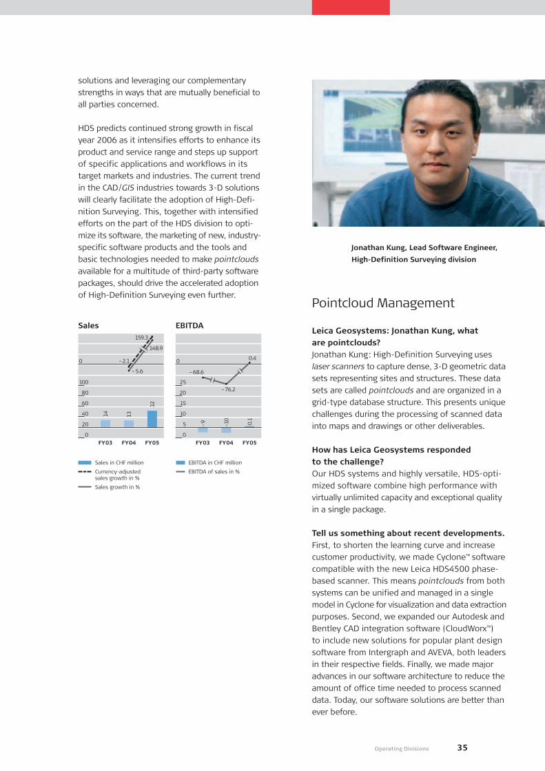
35Operating Divisions
solutions and leveraging our complementary
strengths in ways that are mutually beneficial to
all parties concerned.
HDS predicts continued strong growth in fiscal
year 2006 as it intensifies efforts to enhance its
product and service range and steps up support
of specific applications and workflows in its
target markets and industries. The current trend
in the CAD/GIS industries towards 3-D solutions
will clearly facilitate the adoption of High-Defi-
nition Surveying. This, together with intensified
efforts on the part of the HDS division to opti-
mize its software, the marketing of new, industry-
specific software products and the tools and
basic technologies needed to make pointclouds
available for a multitude of third-party software
packages, should drive the accelerated adoption
of High-Definition Surveying even further.Pointcloud Management
Leica Geosystems: Jonathan Kung, what are pointclouds?Jonathan Kung: High-Definition Surveying uses
laser scanners to capture dense, 3-D geometric data
sets representing sites and structures. These data
sets are called pointclouds and are organized in a
grid-type database structure. This presents unique
challenges during the processing of scanned data
into maps and drawings or other deliverables.
How has Leica Geosystems responded to the challenge?Our HDS systems and highly versatile, HDS-opti-
mized software combine high performance with
virtually unlimited capacity and exceptional quality
in a single package.
Tell us something about recent developments.First, to shorten the learning curve and increase
customer productivity, we made Cyclone™ software
compatible with the new Leica HDS4500 phase-
based scanner. This means pointclouds from both
systems can be unified and managed in a single
model in Cyclone for visualization and data extraction
purposes. Second, we expanded our Autodesk and
Bentley CAD integration software (CloudWorx™)
to include new solutions for popular plant design
software from Intergraph and AVEVA, both leaders
in their respective fields. Finally, we made major
advances in our software architecture to reduce the
amount of office time needed to process scanned
data. Today, our software solutions are better than
ever before.
Jonathan Kung, Lead Software Engineer,
High-Definition Surveying division
Sales in CHF million
Currency-adjusted sales growth in %
Sales growth in %
EBITDA in CHF million
EBITDA of sales in %
FY03 FY04 FY05
32
1314
0
100
80
60
40
20
0
FY03 FY04 FY05
0.1
–10
–9
0
25
20
15
10
5
0
Sales EBITDA159.3
–5.6
–2.1
148.9
0.4
–68.6
–76.2
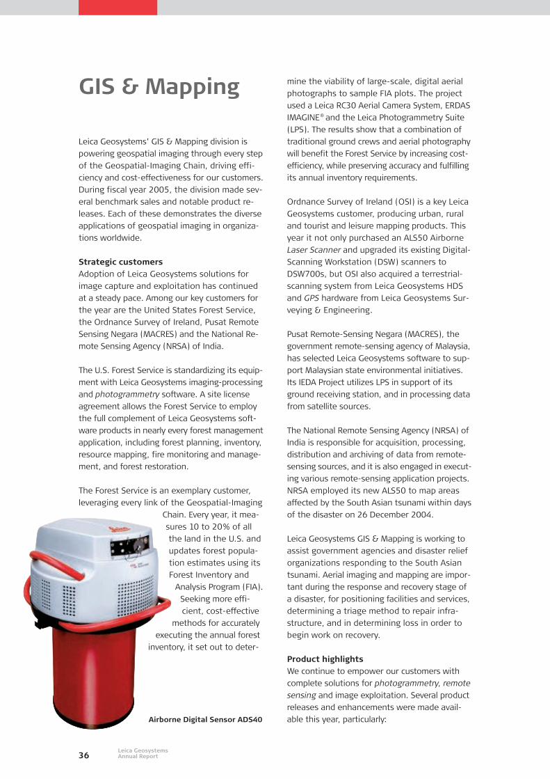
36Leica GeosystemsAnnual Report
mine the viability of large-scale, digital aerial
photographs to sample FIA plots. The project
used a Leica RC30 Aerial Camera System, ERDAS
IMAGINE® and the Leica Photogrammetry Suite
(LPS). The results show that a combination of
traditional ground crews and aerial photography
will benefit the Forest Service by increasing cost-
efficiency, while preserving accuracy and fulfilling
its annual inventory requirements.
Ordnance Survey of Ireland (OSI) is a key Leica
Geosystems customer, producing urban, rural
and tourist and leisure mapping products. This
year it not only purchased an ALS50 Airborne
Laser Scanner and upgraded its existing Digital-
Scanning Workstation (DSW) scanners to
DSW700s, but OSI also acquired a terrestrial-
scanning system from Leica Geosystems HDS
and GPS hardware from Leica Geosystems Sur-
veying & Engineering.
Pusat Remote-Sensing Negara (MACRES), the
government remote-sensing agency of Malaysia,
has selected Leica Geosystems software to sup-
port Malaysian state environmental initiatives.
Its IEDA Project utilizes LPS in support of its
ground receiving station, and in processing data
from satellite sources.
The National Remote Sensing Agency (NRSA) of
India is responsible for acquisition, processing,
distribution and archiving of data from remote-
sensing sources, and it is also engaged in execut-
ing various remote-sensing application projects.
NRSA employed its new ALS50 to map areas
affected by the South Asian tsunami within days
of the disaster on 26 December 2004.
Leica Geosystems GIS & Mapping is working to
assist government agencies and disaster relief
organizations responding to the South Asian
tsunami. Aerial imaging and mapping are impor-
tant during the response and recovery stage of
a disaster, for positioning facilities and services,
determining a triage method to repair infra-
structure, and in determining loss in order to
begin work on recovery.
Product highlights We continue to empower our customers with
complete solutions for photogrammetry, remote
sensing and image exploitation. Several product
releases and enhancements were made avail-
able this year, particularly:
GIS & Mapping
Leica Geosystems’ GIS & Mapping division is
powering geospatial imaging through every step
of the Geospatial-Imaging Chain, driving effi-
ciency and cost-effectiveness for our customers.
During fiscal year 2005, the division made sev-
eral benchmark sales and notable product re-
leases. Each of these demonstrates the diverse
applications of geospatial imaging in organiza-
tions worldwide.
Strategic customersAdoption of Leica Geosystems solutions for
image capture and exploitation has continued
at a steady pace. Among our key customers for
the year are the United States Forest Service,
the Ordnance Survey of Ireland, Pusat Remote
Sensing Negara (MACRES) and the National Re-
mote Sensing Agency (NRSA) of India.
The U.S. Forest Service is standardizing its equip-
ment with Leica Geosystems imaging-processing
and photogrammetry software. A site license
agreement allows the Forest Service to employ
the full complement of Leica Geosystems soft-
ware products in nearly every forest management
application, including forest planning, inventory,
resource mapping, fire monitoring and manage-
ment, and forest restoration.
The Forest Service is an exemplary customer,
leveraging every link of the Geospatial-Imaging
Chain. Every year, it mea-
sures 10 to 20% of all
the land in the U.S. and
updates forest popula-
tion estimates using its
Forest Inventory and
Analysis Program (FIA).
Seeking more effi-
cient, cost-effective
methods for accurately
executing the annual forest
inventory, it set out to deter-
Airborne Digital Sensor ADS40
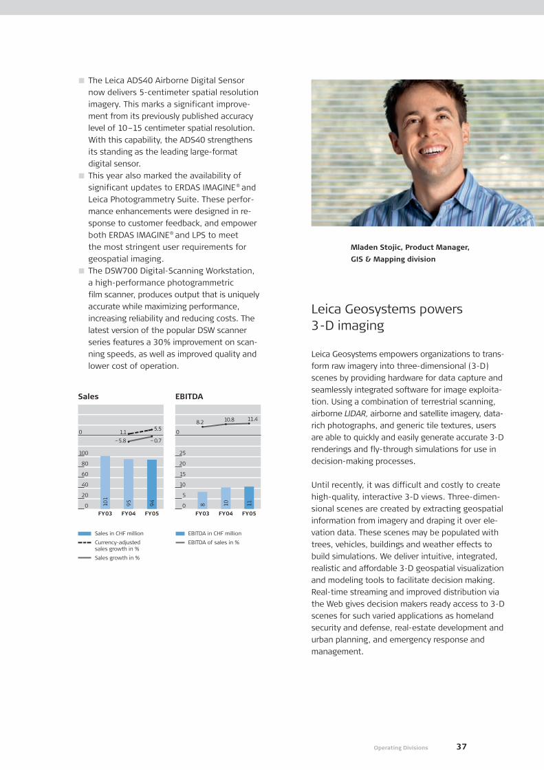
37Operating Divisions
The Leica ADS40 Airborne Digital Sensor
now delivers 5-centimeter spatial resolution
imagery. This marks a significant improve-
ment from its previously published accuracy
level of 10–15 centimeter spatial resolution.
With this capability, the ADS40 strengthens
its standing as the leading large-format
digital sensor.
This year also marked the availability of
significant updates to ERDAS IMAGINE® and
Leica Photogrammetry Suite. These perfor-
mance enhancements were designed in re-
sponse to customer feedback, and empower
both ERDAS IMAGINE® and LPS to meet
the most stringent user requirements for
geospatial imaging.
The DSW700 Digital-Scanning Workstation,
a high-performance photogrammetric
film scanner, produces output that is uniquely
accurate while maximizing performance,
increasing reliability and reducing costs. The
latest version of the popular DSW scanner
series features a 30% improvement on scan-
ning speeds, as well as improved quality and
lower cost of operation.
Leica Geosystems powers 3-D imaging
Leica Geosystems empowers organizations to trans-
form raw imagery into three-dimensional (3-D)
scenes by providing hardware for data capture and
seamlessly integrated software for image exploita-
tion. Using a combination of terrestrial scanning,
airborne LIDAR, airborne and satellite imagery, data-
rich photographs, and generic tile textures, users
are able to quickly and easily generate accurate 3-D
renderings and fly-through simulations for use in
decision-making processes.
Until recently, it was difficult and costly to create
high-quality, interactive 3-D views. Three-dimen-
sional scenes are created by extracting geospatial
information from imagery and draping it over ele-
vation data. These scenes may be populated with
trees, vehicles, buildings and weather effects to
build simulations. We deliver intuitive, integrated,
realistic and affordable 3-D geospatial visualization
and modeling tools to facilitate decision making.
Real-time streaming and improved distribution via
the Web gives decision makers ready access to 3-D
scenes for such varied applications as homeland
security and defense, real-estate development and
urban planning, and emergency response and
management.
Mladen Stojic, Product Manager,
GIS & Mapping division
Sales in CHF million
Currency-adjusted sales growth in %
Sales growth in %
EBITDA in CHF million
EBITDA of sales in %
FY03 FY04 FY05
94
95
101
0
100
80
60
40
20
0
–5.8
Sales EBITDA
FY03 FY04 FY05
11108
0
25
20
15
10
5
0
1.1
–0.7
5.5
11.410.88.2

Despite increasing pressure from the competi-
tion, Leica DISTO™ continued to grow at a healthy
rate during the past fiscal year. Unit sales growth
was in excess of 15% while the value of sales
was up by 7.9% in local currency. Gross profit,
too, rose in response to the division’s new strat-
egy of placing more emphasis on higher-end
products, such as the Classic5a and Plus, and the
further optimization of the “pay-as-you-go”
principle. Worldwide, architects, engineers and
the property-related industries benefited from
being able to integrate the DISTO™ Plus into
their workflow. Private-label business, another
important component in the division’s strategy,
likewise continued to thrive and rose as a pro-
portion of sales.
Focused distribution structureThanks largely to a sharply focused distribution
structure, we were able to meet two of our
major targets for the past fiscal year: to expand
market coverage; and to optimize distribution
costs. Achievement of both these objectives en-
abled us to post a strong financial performance
for the year.
Through our private-label
partners, who distribute
Leica DISTO™ under their
own well-known brand
names, we have ready ac-
cess to hundreds of thou-
sands of professionals and
specialists worldwide.
Although they represent
only a relatively small pro-
portion of total sales, our
private-label partners’
brands and product baskets
give us a unique competi-
tive advantage. At the same
ConsumerProducts
38Leica GeosystemsAnnual Report
time, the extensive reach of our Leica Geo-
systems dealer network allows us to address en-
gineers, surveyors and architects in every corner
of the globe. Finally, several new, segment-spe-
cific distribution partners couple their expertise
with the unrivalled efficiency of Leica DISTO™
to create unique solutions to measurement chal-
lenges anywhere on earth.
In keeping with our strategic goals, we have
substantially increased revenues from our key
accounts and are implementing strategies to
guarantee that this continues in the years ahead.
Our new global distribution partners will be
creating new opportunities in segments where
customers quickly understand the value propo-
sition represented by the Leica DISTO™ solution.
On course for sustained growthIn the course of the year, we rolled out a global
campaign that will steadily increase the number
of points of sale around the world. This has
already helped generate double-digit growth in
the Americas and Asia, as well as a steady rise
in western European markets, which have con-
siderably less room for expansion. Our aim is to
continue improving distribution with a view to
reaching end users through all the channels at
our disposal.
Leica DISTO™ is now seen on job sites all over the
world. The Leica DISTO™ name is synonymous
with cutting-edge laser measurement technology
and continues to be the first choice of profes-
sionals in a vast range of trades and disciplines.
Now that we have succeeded in improving the
distribution, we look to the future with confi-
dence.
Leica DISTO™ Plus
Sales in CHF million
Currency-adjusted sales growth in %
Sales growth in %
EBITDA in CHF million
EBITDA of sales in %
FY03 FY04 FY05
62
59
51
0
100
80
60
40
20
0
14.8
15.9
7.9
FY03 FY04 FY05
1596
0
25
20
15
10
5
0
11.814.4
23.9
Sales EBITDA
6.2

39Operating Divisions
Bettina Messmer, Product Manager,
Consumer Products division
Success through Dynamic Product Management
The Leica DISTO™ Laser Distance Meter holds a
strong position in a dynamic and attractive growth
market. The stiffly competitive nature of this
market results in a relatively short product life cycle,
comparable with other technical consumer goods,
such as digital cameras. Although significant inno-
vations are launched at relatively short intervals, it
is vital that we operate an active life cycle manage-
ment program for each product generation. This
enables Leica Geosystems to respond rapidly to
changes in the market environment and to keep
a step ahead of the competition.
In view of the fact that we did not release a new
generation of products during the past fiscal year,
we focused our strategic marketing efforts on
life cycle management activities, with the aim of
increasing the competitiveness of the current
generation of instruments and consolidating our
leading market position. Although the current
generation of products is still the benchmark for
the industry, we introduced a number of selected
actions that further improved the strategic position-
ing of our product lines.
In the course of this year, the division successfully
launched two new products. The Leica DISTO™
classic5a superseded the current generation, offer-
ing increased measurement accuracy with a new,
innovative color design. In addition, to mark
the sale of a total of 750,000 DISTO™ products, the
division offered the Leica DISTO™ special5, a special
limited edition, which thanks to its attractive po-
sitioning between beginner and advanced models,
appeals to new customer segments.

40
prompted Frost & Sullivan to declare the Local-
Positioning-Technology-based (LPT) T-Probe and
T-Scan the winners of their 2004 Industrial Auto-
mation Product Innovation of the Year Award.
The New-York-based company said the nomina-
tion acknowledges Leica Geosystems’ “excellence
in technology leadership within its industry.”
After successful on-site benchmark tests, the
first T-Scans were shipped to customers in Asia
and the US in February. The official launch and
production ramp-up are planned for the first
quarter of fiscal year 2006. The T-Scan will facil-
itate and expedite Leica Geosystems’ entry into
high-accuracy digitization for the aerospace and
automotive industries.
In November 2004, Leica Geosystems signed a
global software license and collaboration agree-
ment with Metrologic Group, a leading 3-D
industrial measurement software provider. Leica
Geosystems’ portable CMM’s will feature custom-
ized Metrolog XG for Leica Geosystems software,
the best of its kind on the market, and custom-
ers will benefit from twice-yearly updates.
Consolidating our global positionThese moves will strengthen Leica Geosystems’
leading position as a complete-solution provider
to the automotive, aerospace and general pre-
cision industries. The division already supplies
all the aerospace industry’s big players, such as
Lockheed Martin, Boeing, Northrop Grumman,
Alenia Aeronautica, M-Torres and Eurocopter,
and has delivered more than 100 portable CMM
systems to Airbus A380 plants across Europe.
The division has also launched several initiatives
in Asia. A distribution agreement signed last
year with Tokyo Boeki Techno Systems in Japan
is yielding first results. The automotive industry
has placed orders for several portable CMM sys-
tems, and we predict higher sales in the near
future. As part of the division’s initiative in China,
several sales people were hired to better ad-
dress the automotive market and strengthen our
solid position in aerospace.
Service and support are key components in the
Metrology division’s strategy. As a highly cus-
tomer-oriented company, we strive to provide
the best service and support in the industry.
The increase in service and support revenue
(+9% compared with the previous year) can be
Fiscal year 2005 saw the first shipments of
Leica Geosystems’ new T-Probe, the award-win-
ning walk-around coordinate measuring machine
(CMM). Famous names like Airbus, Boeing or
Eurocopter in aerospace, and Ford, Rolls Royce,
BMW and others in the automotive industry
now benefit from the device’s outstanding fea-
tures. Despite the successful product launch,
the Metrology division had a challenging year.
Sales came in slightly below the prior year, but
on a currency-adjusted basis increased 3.2%.
Operating margins were also under pressure
during the year. The Metrology division closed
the year with an 11.5% EBITDA margin, down
from last year’s 18.9%. Profitability declined due
to the combined effects of lower gross margin
and increased operating investments. The time-
consuming launch of the T-Probe pushed sales
down during the first two quarters, but these
were followed by three very strong months and
an excellent fourth quarter. Several new sales
and marketing staff were hired to
promote the products to new sectors,
especially the automotive industry.
Recognition for technologicalleadershipThe handheld, wire-
less T-Probe was well re-
ceived by the market. Sales
to the automotive industry in-
creased substantially within six
months and helped strengthen
Leica Geosystems’ position
as a leading 3-D industrial
measurement solution
provider. An in-depth
analysis of the
product’s
features and
benefits backed
by market research
Metrology
T-Probe
Leica GeosystemsAnnual Report

41Operating Divisions
seen as a confirmation and appreciation of our
effort. For the upcoming fiscal year 2006, Me-
trology expects to continue to grow revenues in
line with previously communicated targets. The
division’s assumptions are based on orders from
new aerospace projects, further penetration of
the automotive and general industries thanks to
new Local-Positioning Technology solutions, and
realization of market opportunities through fo-
cused sales and marketing efforts.
Making Inroads in the Automotive Industry
Three years ago, Metrology’s European sales team
decided to even out market penetration in our key
sectors. We calculated that our Local-Positioning
Technology (LPT) would enable us to compete
against large CMM competitors and branch out into
other areas. So, we started a campaign to train our
sales and support people in these new applications
and introduce Leica Geosystems to customers who
were unaware of our metrology solutions.
Our large-volume, portable probing system has giv-
en many customers an exciting solution to old
measurement problems. Either of the methods pre-
viously used – large, fixed CMMs or smaller probing
arms – created an accumulation of errors and in-
creased measurement time that has long plagued
the measurement world.
One year after launch and the signing of a
strategic alliance to supply our portable CMMs with
Metrolog XG for Leica Geosystems Software, our
strategy is paying off. A lull in the aerospace indus-
try has been followed by success with automotive
and general industrial manufacturing applications.
In our first year, we delivered T-Probe systems to a
significant number of major car manufactures in-
cluding Renault F1. To quote Micky Nolan of Renault
F1, “The Leica Laser Tracker and T-Probe is the only
measurement system on the market that fulfils the
Renault F1 Team criteria.”
Duncan Redgwell, Vice President Sales
Europe, Metrology division
Sales in CHF million
Currency-adjusted sales growth in %
Sales growth in %
EBITDA in CHF million
EBITDA of sales in %
FY03 FY04 FY05
66
66
59
0
100
80
60
40
20
0
Sales EBITDA
FY03 FY04 FY05
81313
0
25
20
15
10
5
0
15.2
11.9 3.2
–0.9
11.518.922.1
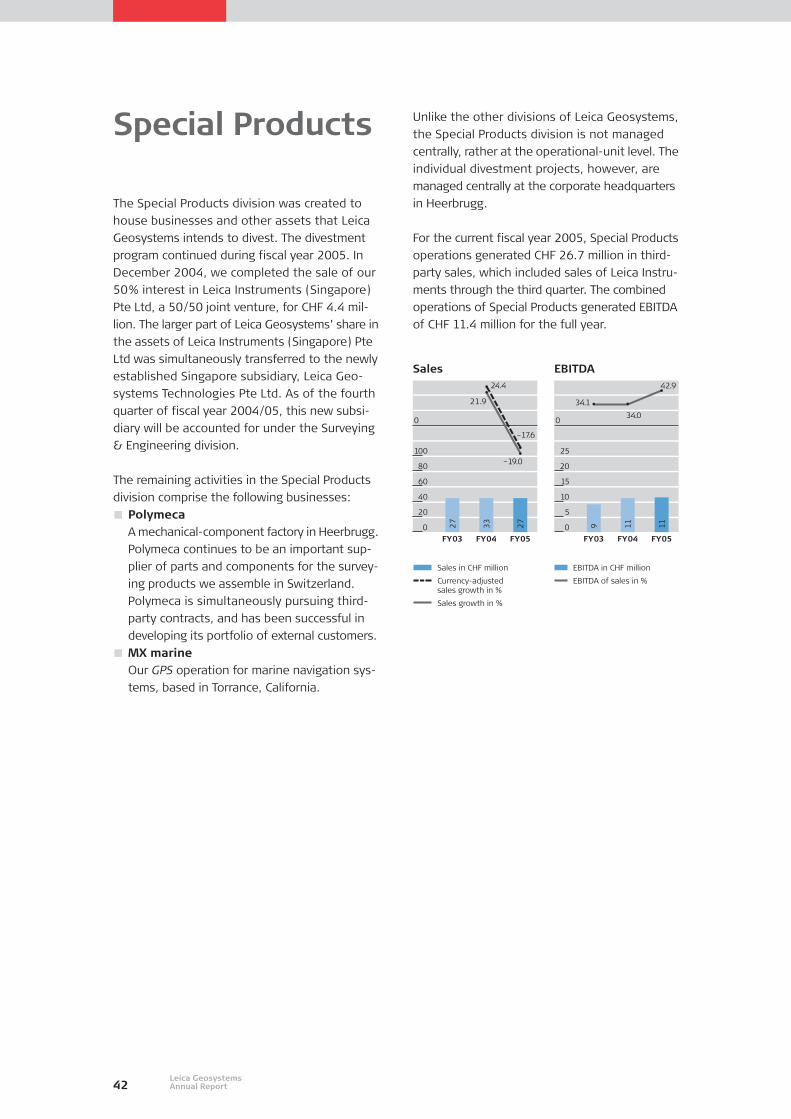
42Leica GeosystemsAnnual Report
The Special Products division was created to
house businesses and other assets that Leica
Geosystems intends to divest. The divestment
program continued during fiscal year 2005. In
December 2004, we completed the sale of our
50% interest in Leica Instruments (Singapore)
Pte Ltd, a 50/50 joint venture, for CHF 4.4 mil-
lion. The larger part of Leica Geosystems’ share in
the assets of Leica Instruments (Singapore) Pte
Ltd was simultaneously transferred to the newly
established Singapore subsidiary, Leica Geo-
systems Technologies Pte Ltd. As of the fourth
quarter of fiscal year 2004/05, this new subsi-
diary will be accounted for under the Surveying
& Engineering division.
The remaining activities in the Special Products
division comprise the following businesses:
PolymecaA mechanical-component factory in Heerbrugg.
Polymeca continues to be an important sup-
plier of parts and components for the survey-
ing products we assemble in Switzerland.
Polymeca is simultaneously pursuing third-
party contracts, and has been successful in
developing its portfolio of external customers.
MX marineOur GPS operation for marine navigation sys-
tems, based in Torrance, California.
Special Products Unlike the other divisions of Leica Geosystems,
the Special Products division is not managed
centrally, rather at the operational-unit level. The
individual divestment projects, however, are
managed centrally at the corporate headquarters
in Heerbrugg.
For the current fiscal year 2005, Special Products
operations generated CHF 26.7 million in third-
party sales, which included sales of Leica Instru-
ments through the third quarter. The combined
operations of Special Products generated EBITDA
of CHF 11.4 million for the full year.
Sales in CHF million
Currency-adjusted sales growth in %
Sales growth in %
EBITDA in CHF million
EBITDA of sales in %
FY03 FY04 FY05
27
33
27
0
100
80
60
40
20
0
Sales EBITDA
FY03 FY04 FY05
11119
0
25
20
15
10
5
0
34.0
34.1
42.9
–19.0
21.9
–17.6
24.4

43Locations
Leica Geosystems Worldwide
Leica Geosystems has
subsidiaries in 21 countries,
with over 120 agencies
worldwide.
Europe
Belgium
Denmark
France
Germany
Italy
Netherlands
Norway
Portugal
Russia
Spain
Sweden
Switzerland
United Kingdom
Asia Pacific
Australia
China
Japan
Korea
Singapore
North and
South America
Canada
Mexico
United States

Company Contact Information
Corporate Headquarters
Leica Geosystems AGHeinrich-Wild-StrasseCH-9435 HeerbruggPhone +41 71 727 3131Fax +41 71 727 4674
Investor RelationsPhone +41 71 727 3064
Corporate CommunicationPhone +41 71 727 4252
Divisional Headquarters
Surveying & Engineering divisionLeica Geosystems AGHeinrich-Wild-StrasseCH-9435 HeerbruggPhone +41 71 727 3131Fax +41 71 727 4674President: Clement Woon
High-Definition Surveying(HDS) divisionLeica Geosystems HDS, LLC4550 Norris Canyon RoadSan Ramon, CA 94583USAPhone +1 925 790 2300Fax +1 925 790 2309President: Erwin Frei(through May 2005)
GIS & Mapping divisionLeica GeosystemsGIS & Mapping, LLC2801 Buford Highway NE, Suite 300Atlanta, Georgia 30329-2137USAPhone +1 404 248 9000Fax +1 404 248 9400President: Bob Morris
Consumer Products divisionLeica Geosystems AGHeinrich-Wild-StrasseCH-9435 HeerbruggPhone +41 71 727 3131Fax +41 71 727 4674President: Klaus Brammertz
Metrology divisionLeica Geosystems AGMönchmattweg 5CH-5035 UnterentfeldenPhone +41 62 737 6767Fax +41 62 723 0734President: Walter Mittelholzer
44Leica GeosystemsAnnual Report
Primary Manufacturing Facilities
Leica Geosystems AGHeinrich-Wild-StrasseCH-9435 HeerbruggPhone +41 71 727 3131Fax +41 71 727 4674
Leica Geosystems Technologies Pte Ltd2 WoodlandsSector 1 #01–10Woodland East Industrial EstateSingapore 738068
Polymeca AGHeinrich-Wild-StrasseCH-9435 HeerbruggPhone +41 71 727 4141Fax +41 71 727 4720Contact: Heinz Christen
Sales Companies
AustraliaLeica Geosystems Pty Ltd.Gladstone Road, Dutton ParkBrisbane, QLD 4102AustraliaPhone +61 7 3891 9772Fax +61 7 3891 9336Contact: Martin Nix
Leica GeosystemsGIS & Mapping Pty Ltd.P.O. Box 213Glenbrook, NSW 2773AustraliaPhone +61 2 4739 0669Fax +61 2 4739 0339Contact: Steve Gaynor
BelgiumLeica Geosystems NVPegasus ParkDe Kleetlaan 4, bus 2B-1831 DiegemPhone +32 2 209 0700Fax +32 2 209 0701Contact: Rene Worms
CanadaLeica Geosystems Ltd.513 McNicoll AvenueWillowdaleOntario M2H 2C9CanadaPhone +1 416 497 2460Fax +1 416 497 2053Contact: Bob Williams
Greater China RegionLeica Geosystems AGBeijing Representive OfficeRoom 1808, China Life Building16, Chao Yang Men DajieChao Yang DistrictBeijing 10020People’s Republic of ChinaPhone +86 10 8525 1838Fax +86 10 8525 1836Contact: Peter Lippmann
Leica Geosystems Ltd.Room 1701-325, Westlands RoadQuarry BayHong KongPeople’s Republic of ChinaPhone +852 2564 2299Fax +852 2564 4199Contact: Peter Lippmann
Leica Geosystems (Shanghai) Co. Ltd.Room 10402–10404No. 498 Guoshoujing RoadPudong Software ParkShanghai 201203People’s Republic of ChinaPhone +86 21 5027 1218Fax +86 21 5027 1228Contact: Hans Ni
Leica Geosystems (Wuhan) Co. Ltd.The 1st Floor, Incubator BuildingWuhan University Science ParkJiangxia Avenue, East Lake TechnologyDevelopment ZoneWuhan 430223People’s Republic of ChinaPhone +86 27 8719 6190Fax +86 27 8719 6190Contact: Deyang Wu
DenmarkLeica Geosystems A/SHorkaer 12ADK-2730 HerlevPhone +45 4454 0202Fax +45 4454 0222Contact: Morten Rasmussen
FinlandLeica Nilomark OY (10.5% JV)Sinimäentie 10CP.O. Box 111SF-02631 EspooPhone +358 9 6153 555Fax +358 9 5022 398Contact: Seppo Salo
FranceLeica Geosystems SarlParc du Saint-Laurent54, route de SartrouvilleBâtiment le QuébecF-78232 Le Pecq CedexPhone +33 1 3009 1700Fax +33 1 3009 1701Contact: Jean-Philippe Picon
GermanyLeica Geosystems GmbH VertriebHans-Bunte-Strasse 5D-80992 MünchenPhone +49 89 1498 10 0Fax +49 89 1498 10 33Contact: Lothar Assenmacher
ItalyLeica Geosystems S.p.A.Via Condognino 12I-26854 Cornegliano Laudense (LO)Phone +39 0371 697321Fax +39 0371 697333Contact: Andrea Cabrucci

45Locations
JapanLeica Geosystems K.K.Regional Headquarters Surveying & Engineering DivisionBunkyo Green Court, Bldg.21F, 2-28-8 HonkomagomeBunkyo-ku, Tokyo 113-6591JapanPhone +81 3 5940 3011Fax +81 3 5940 3012Contact: Tsutomu Kohara
KoreaLeica Geosystems KK, Korea BranchGuGu Building, 1F145-18 Samsung-dongGangnam-gu, Seoul 135-090Phone +82 2 598 1919Fax +82 2 598 9686Contact: Y. K. Choi
MexicoLeica Geosystems S.A. de C.V.Porfirio Diaz, Pte No. 35Colonia Nochebuena03720 Mexico D.F.Phone +525 563 5011Fax +525 611 3243Contact: Cesar Lanatta
NetherlandsLeica Geosystems B.V.Cobbenhagenstraat 7NL-2288 ET RijswijkPhone +31 70 307 89 00Fax +31 70 307 89 19Contact: Rene Worms
NorwayLeica Geosystems ASBrobekkveien 80N-0582 OsloPostboks 502N-0512 OsloPhone +47 22 709 180Fax +47 22 255 624Contact: Morten Rasmussen
PortugalLeica Geosystems – SistemasPara Topgrafia e GeodesiaSociedade Unipessoal, LtdaEstrada de PolimaArmazém Christel Peitz, S/NAboboda – PolimaP-2785-543 Salo Domingos de RanaPhone +351 214 480 930Fax +351 214 480 931Contact: Jaime Fernandez
RussiaLeica Geosystems OOOPartiyny pereulok, 1/57 stroenie 3,Business Center M-stilyOffice 203/204113093 MoscowRussiaPhone +7 095 250 72 69Fax +7 095 250 72 53Contact: Vladimir Gulin
SingaporeLeica Geosystems (Singapore) Pte Ltd#04-55/58 German Center25 International Business ParkSingapore 609916Phone +65 6776 9318Fax +65 6774 7145Contact: Matthew Smith
SpainLeica Geosystems S.L.Nicaragua 46, 5° 4aE-08029 BarcelonaPhone +34 93 494 9440Fax +34 93 494 9442Contact: Jaime Fernandez
SwedenLeica Geosystems ABGlimmervägen 14Box 781S-19127 SollentunaPhone +46 8 625 3000Fax +46 8 625 3010Contact: Morten Rasmussen
SwitzerlandLeica Geosystems AGEuropastrasse 21CH-8152 GlattbruggPhone +41 1 809 3311Fax +41 1 810 7937Contact: Hans-Ulrich Müller
Leica Geosystems GIS & Mapping GmbHHeinrich-Wild-StrasseCH-9435 HeerbruggPhone +41 71 727 3465Fax +41 71 727 4691Contact: Michael Hut
United KingdomLeica Geosystems Ltd.Regional Headquarters Surveying &Engineering DivisionDavy AvenueMilton Keynes MK5 8LBUnited KingdomPhone +44 1908 256 500Fax +44 1908 609 992Contact: Mark Concannon
USALeica Geosystems Inc.Regional Headquarters Surveying & Engineering Division5051 Peachtree Corners CircleSuite 250Norcross, GA 30092USAPhone +1 770 326 9500Fax +1 770 447 0710Contact: Bob Williams

46Leica GeosystemsAnnual Report
Glossary
Coordinate Measuring Machine (CMM)This machine is normally fixed inplace with a maximum volume of 3–5–8 meters. It incorporates a probe, which can be slid alongthree physically defined and mu-tually perpendicular axes. An ob-ject to be measured is placed onthe machine. By touching a probeagainst the object, the currentcontact position of the probedefines a point on the object thatyields its three coordinates.
Electronic Distance Measurement (EDM)EDM is based on the idea thatlight travels at a finite velocityand measures the time it takesfor a signal to travel back andforth between two points. Thetwo primary technical principlesof electronic distance measure-ment are (1) time of flight – thedirect measurement of the timeelapsed between the emissionand the reception of a light pulse,and (2) phase difference – themeasurement of the differencebetween the emitted and re-flected light while its emitted in-tensity is continuously changedin intensity over time.
GeomaticsThe science or profession re-lated to the process of capturingand using spatial data throughinformation technology. Broadranges of applications are partof, or associated with, geomatics,including surveying, geography,and mapping.
GeoreferenceThe established relationship between any kind of data likethe page coordinates on a pla-nar map or an aerial image andthe real-world coordinates.
GIS (Geographic Information System)An integrated set of hardwareand software designed to input,
store, manipulate, and output,geographically referenced data(i.e. geographic information). Anydata referenced to a location onthe Earth can be considered geo-graphic information. All geograph-ic information has three compo-nents: the attribute of interest(i.e. a measurement or class suchas temperature or forest type),the location to which the attri-bute refers, and time (i.e. themoment or period of time whenthe attribute was observed).
GNSS/GPS – Global NavigationSatellite SystemsThese satellite-based systemsprovide signals for positioningand navigation. GNSS includes,but is not limited to, GPS, theRussian supported Glonass sys-tem, the planned EuropeanGalileo system and various an-cillary systems such as WAAS for North America, a system ofsatellites launched by the USADepartment of Defense. The con-stellation of Navstar satellitesthat orbit the Earth provide po-sition and time information byemitting radio signals.
GPS Reference StationA GPS receiver based on a fixedpoint, providing its measure-ments to roving (i.e. mobile ormoving) receivers in order toallow those receivers to improvetheir positioning accuracy.
Laser ScannerCaptures reality by digitizing anobject with a laser. Every trans-mitted laser pulse is used tomeasure a distance to the pointof reflection, and simultaneously,horizontal and vertical anglemeasurements are taken. Thesebasic measurements are used tocalculate three-dimensional co-ordinates for individual points. A Laser Scanner is typically ableto measure between 1,000 and2,000 points per second to an ac-curacy of less than 1 centimeter.
Laser ScanningA technique to capture reality ina three-dimensional manner. A typical laser scanning systemconsists of a Laser Scanner toacquire the Cloud of points anda PC-based software package to visualize and further processthe data.
Laser TrackerA dynamic tracking laser inter-ferometer. The instrument uses an interferometer beam targetedonto a retro-reflector. If the re-flector moves, the return beamshifts laterally. This shift is detect-ed and the tracker moves to bringthe beam back on line again. Inthis way a tracking mechanismis established. The angle and in-terferometer readings are contin-uously monitored and convertedinto three-dimensional coordi-nates at 1,000 times per second,the rate at which a moving re-flector can be tracked in space.
LIDARAn acronym for LIght DetectionAnd Ranging, is often used as asynonym for EDM.
MetrologyThe science of dimensionalmeasurement in one, two, andthree dimensions.
PhotogrammetryThe application of photographicprinciples to the science of map-ping – the science of obtainingreliable spatial measurementsfrom imagery.
Pointcloud/Cloud of pointsThe result of scanning an objector a scene in reality with a LaserScanner. A Cloud of points typi-cally consists of thousands ofindividual points, which gener-ate a digitized, fully three-di-mensional representation of thescene or object in question. Eachpoint within a Cloud of points is defined by three coordinates

47Glossary
(x, y, z), as well as other addi-tional information like color orreflectivity. Clouds of points serveas a basis to visualize the cap-tured objects on a PC and/or toextract geometrical informationfrom the scanned objects toserve a multitude of applications.
Portable CMM (PCMM) InstrumentsMobile CMMs that enable the in-strument to be brought closer tothe object in question. PortableCMMs may be laser trackers, digi-tal photogrammetry (videogram-metry) systems, total stations,laser scanners or articulated arms.
Remote SensingA group of techniques for col-lecting images or other forms ofdata about an object from mea-surements made at a distancefrom the object, and the pro-cessing and analysis of the data.Remote Sensing can be cate-gorized into the following sub-systems:
Active System. A remote sens-ing system that transmits itsown electromagnetic emana-tions at an object(s) and thenrecords the energy reflectedor refracted back to the sensor. Radar is an example of an active system. It sends out pulses of microwaves and then receives the echo reflected from the target. Passive Sensing. A sensing sys-tem that detects or measuresradiation emitted or reflectedby the target. The signal re-ceived by the passive sensormay be composed of energyemitted by the atmosphere,reflected energy from the sur-face, energy emitted by thetarget, or energy transmittedthen emitted by the surface. Aerial Sensing. Remote sens-ing from an airborne platform. Satellite Sensing. Remotesensing from a satellite plat-form.
Terrestrial Positioning Systems (TPS)Systems that measure anglesand distances by using a combi-nation of lenses, prisms andmirrors, together with associatedlaser technologies and softwareapplications, in traditional sur-veying products such as levels,theodolites, distancers and totalstations.
TheodoliteAn instrument for measuringangles from a measuring stationto a remote target point. Thepointing is made using a tele-scope, which rotates about twointersecting orthogonal axes. Thehorizontal and vertical anglesmeasured on these axes definethe pointing.
Three-Dimensional Digitizingand VisualizationA variety of technologies thatfacilitate the rapid acquisition,management, handling and representation of enormous volumes of spatial data. Today,multicamera systems and, increasingly, laser scanners areused for data acquisition. Whereas camera systems needextensive computer processing,laser scanners deliver a 3-Ddigital model directly.
Total StationA theodolite equipped with anintegrated electronic distancemeter, which enables it to mea-sure a distance along the line ofsight.
TriangulationA technique by which targetsare located in a global coordinatesystem by measurement of di-rections from two or more fixedand known locations to the sametarget (intersection).

48Leica GeosystemsAnnual Report
Disclaimer
Under the safe harbor provisions of the U.S. PrivateSecurities Litigation ReformAct of 1995, we caution investors that all statements otherthan statements of historical fact included in this document,including without limitation, those regarding our financialposition, business strategy, plans and objectives of manage-ment for future operations (including development plans andobjectives relating to our existing and future products), areforward-looking statements. Such forward-looking statementsinvolve known and unknown risks, uncertainties and otherfactors, which may cause our actual results, performance orachievements, or industry results, to be materially differentfrom any future results, performance or achievements ex-pressed or implied by such forward-looking statements. Suchforward-looking statements are based on numerous assump-tions regarding our present and future business strategies andthe environment in which we expect to operate in the future.Important factors that could cause our actual results, perfor-mance or achievements to differ materially from those in theforward-looking statements include, among other factors: (i) our ability to develop and introduce new products andtechnologies that gain market acceptance on a timely basis;(ii) our ability to respond to competitive challenges, such asthe introduction of innovative products or technologies by our competitors; (iii) our ability to identify and realize growthopportunities; and (iv) overall levels of investment in infra-structure and capital spending in our markets. Additionally,any forward-looking statements speak only as of the date ofthis document. We expressly disclaim any obligation or under-taking to release publicly any update of or revisions to anyforward-looking statement contained herein to reflect anychange in our expectations with regard hereto or any changein events, conditions or circumstances on which any suchstatement is based.
Publishing Details
EditorGeorge Aase, Director Investor Relations,Leica Geosystems AG, Heerbrugg, Switzerland
Concept and designRamstein Ehinger Associates AG, Basel/Zurich, Switzerland
TextMichael Johnson, Zurich, Switzerland
LithographyBlue Horizon AG, Winterthur , Switzerland
PrintingPrintlink AG, Wetzikon, Switzerland
This Annual Report is published in English and German.In the case of inconsistencies in the German translation, the English original version shall prevail.
Photo Credits
IllustrationsAndré Wetter, Fislisbach, Switzerland; Ramstein EhingerAssociates, Basel/Zurich, Switzerland: cover, pp. 2, 10, 20, 28
PhotographyAmberg Messtechnik AG, Regensdorf, Switzerland: p. 28Apostrophe Films Pte Ltd, Singapore: p. 13Howard Brundrett, Meilen, Switzerland: pp. 7, 9, 15, 17, 19,26, 37, 39, 41Corbis: p. 10Dave Dawson, Dave Dawson Photography, USA: p. 33Getty Images: pp. 20, 23, 24, 25Imagepoint: p. 2Institut für Kunstgeschichte, Universität Bern, Switzerland,Prof. Dr. Volker Hoffmann, Nikolaos Theocharis: pp. 10,11Leica Geosystems AG, Heerbrugg, Switzerland: pp. 15, 32, 34, 36, 38, 40 (products)Jonathan Kung, USA: p. 35Opus, Copenhagen, Denmark: cover, pp. 2, 10, 20, 28Prime 8 Photo, USA: pp. 16, 37Prisma Dia: coverWolf Survey & Mapping, Canada: p. 25 (portrait)

Investor & Financial Media ContactGeorge Aase
Director Investor Relations
Phone +41 71 727 30 64
Corporate CommunicationNicholas Bloch
Head of Corporate Communication and
Public Relations
Phone +41 71 727 42 52
Whether building a house or a bridge, a map or an aircraft, you
need reliable measurements. That’s why more companies trust Leica
Geosystems to collect, analyze, and present spatial information.
When it has to be right.
- when it has to be right
Leica Geosystems AGHeinrich-Wild-StrasseCH-9435 HeerbruggSwitzerlandPhone +41 71 727 31 31
www.leica-geosystems.com