legal impacts - sjöfartsverket · the salient features ... key concerns regarding the acceptance...
TRANSCRIPT

LEGAL IMPACTS OF THE MONALISA PROJECT ON
THE INTERNATIONAL LEGAL FRAMEWORK FOR NAVIGATION AT SEA

Proshanto K. Mukherjee1
The author gratefully acknowledges the contributions and assistance of Olena Bokareva2 and Nut Sillwatwinyoo3
1. Professor of Maritime Law and Director of the Maritime Law Programme, Faculty of Law, Lund University.2. Doctoral Candidate, Faculty of Law, Lund University.3. LL.M Graduate in Maritime Law, Faculty of Law, Lund University.
IMPACT OF THE MONALISA PROJECT ON THE INTERNATIONAL LEGAL FRAMEWORK FOR NAVIGATION
AT SEA
Proshanto K. Mukherjee1
(The author gratefully acknowledges the contributions and assistance of Olena Bokareva
2 and Nut Sillwatwinyoo3
1 Professor of Maritime Law and Director of the Maritime Law Programme, Faculty of Law, Lund University. 2 Doctoral Candidate, Faculty of Law, Lund University. 3 LL.M Graduate in Maritime Law, Faculty of Law, Lund University.
1
Abstract
MONALISA is an acronym for Motorways and Electronic Navigation by Intelligence at Sea. It is a visionary concept designed to make a tangible contribution to maritime transportation in terms of safety, efficiency and environmental protection. It has a two-fold objective: one aimed at contributing in a concrete way to safe, efficient and environmentally protective maritime navigation and the other to focus specifically on EU strategy in the Baltic Sea Region.
The salient features of the MONALISA Project are depicted through four activities as follows:
• Dynamic and Proactive Route Planning (DPR) otherwise known as “Green Routes”; • Electronic Verification of Officer’s Certificates; • Ensuring the Quality of Hydrographic Data on Shipping Routes and Areas; • Global Sharing of Maritime Data.
The central core of DPR, and in essence, the MONALISA Project itself, is the concept of sea traffic management (STM) which is akin to air traffic management (ATM). It is anticipated that STM will offer a new service facility known as the Sea Traffic Coordination Center (STCC), similar to air traffic control centres (ATCC) in aviation. The STCC concept will provide new processes and methodologies for communication of information between ship and shore, and ship-to-ship. Apart from DPR the second, third and fourth activities mentioned above are equally significant. This Report focuses on the legal issues relating to the salient features of MONALISA.
One of the key concerns regarding the acceptance and implementation of MONALISA internationally is the potential conflict with certain aspects of UNCLOS particularly in relation to the notion of freedom of the high seas and flag state sovereignty over its vessels on the high seas. Closely associated with UNCLOS issues pertaining to the rights of coastal, port and flag states are issues relating to maritime safety and protection of the marine environment. While UNCLOS provides the basic legal framework for both these matters, the specifics are contained in the two principal IMO Conventions SOLAS and MARPOL. In particular, the SOLAS provisions dealing with navigational safety, have an impact on key aspects of MONALISA since SOLAS largely contemplates control of high seas navigation being in the hands of the shipboard navigators whereas MONALISA envisages the concept of DPR which is a shore based advisory system but final navigational decisions are left to be decided by the ship master. The object is to improve navigational safety and minimize environmental damage through the institution of “green routes”.
Another area of potential concern is the second activity mentioned above which can be viewed as an intrusion into the flag state’s exclusive authority over certification requirements of officers serving on board its ships. However, the end objective of this activity like the first one is to facilitate maritime safety and not to cause an impediment. It is well-known that human error is a primary cause of accidents at sea and that inadequate seafarer qualifications contribute to accidents and environmental damage caused by ships. In monitoring seafarer qualifications
2
MONALISA introduces the concept of the smart card which despite a potential conflict with the existing regime relating to seafarers, can be of great practical usefulness.
Through the MONALISA Project there can be better quality of hydrographic data for the use of ships which in turn can contribute to better navigational safety and protection of the marine environment. Indeed, global sharing of all maritime data serves the same purposes globally as well as in the Baltic Sea Region. The potential conflicts of MONALISA with the extant international legal framework are not irreconcilable. The ultimate aim of MONALISA is consistent with the objectives of the international maritime community to promote maritime safety and protection of the marine environment, and therefore, it should be viewed in positive light by all concerned, especially the international bodies responsible for shipping and its legal framework.

3
Table of Contents
CHAPTER 1 - INTRODUCTION
1.1 Background
1.2 Purpose of Report
1.3 Structure of Report
CHAPTER 2 - SYNOPTIC OVERVIEW OF THE MONALISA PROJECT
2.1 Salient Features
2.1.1 The sea traffic management (STM) concept
2.1.2 Dynamic and proactive route planning “Green Routes”
2.1.3 Verification system for certificates held by ships’ officers
2.1.4 Quality assurance of hydrographic data
2.1.5 Global sharing of maritime information
2.2 Technology versus Law
2.3 Summary of Legal Issues
CHAPTER 3 - ISSUES ARISING OUT OF UNCLOS
3.1 Maritime Zones under UNCLOS
3.1.1 Baselines
3.1.2 Internal waters
3.1.3 Territorial seas
3.1.4 Contiguous zone
3.1.5 Exclusive economic zone
3.1.6 Continental shelf
3.1.7 High seas
4
3.1.8 Freedom of navigation in the EEZ and the high seas
3.1.9 Rights in archipelagic sea lanes
3.1.10 Transit passage in international straits
CHAPTER 4 - IMO AND RELEVANT IMO CONVENTIONS
4.1 Preliminary Remarks
4.2 Safety Conventions SOLAS and COLREGS
4.2.1 SOLAS
4.2.1.1 Ship safety
4.2.1.2 Personal and occupational safety
4.2.1.3 Synoptic structure of SOLAS
4.3 Safety of Navigation
4.4 COLREGS
4.4.1 Background and object
4.4.2 Structure
4.4.3 COLREGS as penal law
4.5 Seafarers’ Qualification, Welfare and the Human Element
4.5.1 STCW Convention
4.5.2 Welfare and the human element
4.6 Search and Rescue
CHAPTER 5 - PROTECTION OF THE MARINE ENVIRONMENT
5.1 General
5.2. MARPOL 73/78 Convention
5.2.1 General characteristics and layout
5
5.2.2 Salient features of article and features common to most annexes
5.2.3 Specific features of each annex
CHAPTER 6 - SPECIFIC LEGAL ISSUES
6.1 Routing Systems, Sea Lanes and Traffic Separation Schemes
6.2 Vessel Traffic System (VTS) and Vessel Traffic Management System (VTMS) under UNCLOS and SOLAS
6.3 Flag State, Port State and Coastal State
6.4 Hydrographic Implications
CHAPTER 7 - POTENTIAL CONFLICTS BETWEEN MONA LISA CONCEPTS AND EXTANT INTERNATIONAL LAW
7.1 Concept of Sea Traffic Management (SMT): Conflict with International Legal Regimes
7.2 The Notion of the Dynamic TSS System
7.3 Concept of the Smart Card, Conflict with STCW, Labour Law under MLC, National Flag State Regimes, Conflict with Unions (ITF) and PSC Regimes
7.4 The Baltic Sea Region and Hydrographic Surveys
CHAPTER 8 - CONCLUSION
8.1 Options for Resolution of Conflicts
8.2 Analogies with National Jurisdictions: Canada's Maritime Traffic Regulatory Regimes
8.3 The STM rationale
6
CHAPTER 1 - INTRODUCTION
1.1 Background
Trade is the life blood of a nation and shipping is the global means by which trade is conducted. Maritime transportation, which is synonymous with shipping, is of crucial importance to society as a whole. Thus, shipping is an integral and inextricable part of global trade simply because over 80% of it is carried out by ships4
It is recognized that despite technological advancements and relatively high levels of proficiency in the maritime vocations, there remain many challenges that maritime transport needs to meet to strengthen competitiveness and contribute to increasingly efficient transportation solutions for the beneficiaries of transportation services. Development of appropriate technology and its optimum use is one way of meeting the challenges.
. In this Report, the terms "shipping" and "maritime transport" or "maritime transportation" are used interchangeably, the emphasis being on the fact that the modality through which international trade is conducted is largely waterborne utilizing varieties of ships. It needs no reiteration that ships today are purpose-built and are the product of sophisticated shipbuilding and navigational and engineering technology. Needless to say, the economic dimension of shipping cannot be discounted, and therefore, efficiency is crucial to the success of the shipping industry and maritime transportation as a whole. Financial considerations are a function of efficiency in shipping which means the benefits derived must be greater than the costs incurred, and that is largely dependent on a range of factors including advancements in the art, science and technology of marine navigation and seafarer competence not to mention the maritime safety and marine environmental considerations.
It is also recognized that within the European Union, maritime transport is of huge significance given the numerous waterways that define the geographical characteristics of the continent of Europe. This has provided the impetus for the initiation of the EU Project generally known as MONALISA which is an acronym for Motorways and Electronic Navigation by Intelligence at Sea. In the EU context it is a part of the so-called Motorways of the Sea Project which is a wider manifestation of the concept taking into account the various parameters that impact on shipping efficiency.
The object of MONALISA is two-fold – one aims at contributing in a concrete fashion to safe, efficient and environmentally protective maritime transportation; the other is to focus specifically on EU strategy in the Baltic Sea Region. Thus the Motorways of the Sea concept can be viewed as the maritime dimension of a Trans-European Transport Network (TEN-T). On the other hand, the MONALISA Project, apart from giving effect to a regional strategy for the Baltic Sea Region, can also contribute to the enhancement of safety, efficiency and environmental consciousness of world shipping. In effect, therefore, MONALISA has a wider application and is of expansive benefit in international terms.
The Swedish Maritime Administration (SMA) as part of the Government of Sweden initiated the MONALISA Project in early 2010. The Swedish initiative flows from its appreciation and
4 Martin Stopford, Maritime Economics, 3rd ed., London and New York: Routledge, 2009, at p. 1.
7
recognition of the fact that maritime transportation plays a central role in the overall strategy of the EU in the transportation field. Its connectivity with European foreign trade and overall economic development of the EU is thus indisputable. The Swedish sensitivity is borne out by the fact that the MONALISA Project was selected for co-financing of 50 % from the EU’s budget for the TEN-T.
MONALISA is a visionary concept which is designed to make a tangible contribution to maritime transportation in terms of safety, efficiency and environmental protection. The execution of this objective is through the institution of innovative navigational services to the shipping industry based on advanced electronic technology. There are several facets and dimensions to this objective which are set out in detail in the first substantive section of this Report.
1.2 Purpose of Report
As can be gleaned from this Report, its principal purpose is to address the legal issues associated with the fast-paced technological innovations characterized by the MONALISA Project. Needless to say, in an attempt to thoroughly examine and analyze the legal issues, the technical or non-legal aspects of the Project must be addressed in necessary contextual detail. The contents of the Report are dictated by the terms of reference (TOR) which are appended to this Report.
1.3 Structure of Report
Given the diversity of legal issues associated with the technological aspects of the project, a synoptic overview is presented in the next section of this Report. In this section, first, the salient features of the Project are highlighted followed by a discussion on the correlation between law and technology which is sometimes in a state of tension with legal developments almost always following well behind the technological innovations. In the context of this Project, this assertion is no different except that it has been recognized by the promoters of the Project within the Swedish establishment that the legal issues need to be addressed in a clear, comprehensive and meaningful manner as early as possible. Hence, the commissioning of this particular inquiry has been initiated at this relatively early stage of the MONALISA Project. A summary of the legal issues is presented at the end of the second section.
Following the summary, in the third section the legal issues arising out of the international regime of the law of the sea codified in the United Nations Convention on the Law of the Sea, 1982 (UNCLOS) are examined in relevant detail. An overview of the maritime zones under UNCLOS is first presented and then the various rights and jurisdictions prevailing under the Convention are discussed. The focus of the discussion is on the interrelationship between rights of coastal states on the one hand and those of flag states, particularly in relation to freedom of navigation and restriction on navigation pertaining to various zones. The discussion extends to the doctrines of freedom of the high seas, innocent passage in territorial seas, rights in archipelagic sea lanes and transit passage in international straits, all of which have an impact on the technological innovations of the MONALISA Project.
8
In a similar vein, the role of the International Maritime Organization (IMO) and the Conventions and treaty instruments generated by it are examined in section 4 of the Report. The discussion extends to examining the salient features of the Safety of Life at Sea (SOLAS) Convention, the Collision Regulations (COLREGS), and the Standards of Training, Certification and Watchkeeping (STCW) Convention. The LOADLINES and Search and Rescue (SAR) Conventions are also mentioned. The concept of the human element which is related to the welfare of seafarers is included in the discussion.
In section 5, protection of the marine environment is discussed by reference to the MARPOL Convention and in section 6 specific legal issues are examined which include routing systems, and traffic separation schemes under UNCLOS, SOLAS and COLREGS and the concepts of vessel traffic systems (VTS) and vessel traffic management systems (VTMS) under UNCLOS and SOLAS are examined. The relative roles of the flag state, coastal state and port state together with the regimes of port state jurisdiction and control (PSJ and PSC) are addressed. Enforcement by the flag, coastal and port states for all types of ship-source pollution is discussed together with the hydrographic implications associated with navigational safety and routing which is at the heart of the MONALISA initiative. In this context, the relative roles of the IMO and the International Hydrographic Organization (IHO) are also considered.
In section 7, potential conflicts between the MONALISA concept and existing international law instruments are addressed. The conflict areas are associated with the newly innovated concept of sea traffic management (STM) and green routing which are central to the MONALISA Project. In this section the concept of the smart card is also addressed in consideration of potential conflict with the STCW Convention and international maritime labour laws. Whether the smart card is compatible with PSC is also examined together with the rights of flag states over their crew members.
Section 8, which is the conclusion of the Report, presents options for resolution of conflicts and inconsistencies. One option is to propose amendments to international instruments and the other is to promote the voluntary application of the MONALISA innovations.
In this context, the maritime traffic regulatory regimes currently operating in Canada are examined to draw analogies between those national regimes and the MONALISA Proposals.
9
CHAPTER 2 - SYNOPTIC OVERVIEW OF THE MONALISA PROJECT5
2.1 Salient Features
The MONALISA Project consists of four activities which are as follows:
Activity 1 - Dynamic and Proactive Route Planning (DPR) otherwise known as “Green Routes”
Activity 2 - Electronic Verification of Officer’s Certificates
Activity 3 - Ensuring the Quality of Hydrographic Data on Shipping Routes and Areas
Activity 4 - Global Sharing of Maritime Data.
2.1.1 The sea traffic management (STM) concept
The central core of DPR, and in essence, the MONALISA Project itself, is the concept of sea traffic management (STM) which is akin to air traffic management (ATM). Indeed the distinction between DPR and traffic regulation as it operates currently is that DPR incorporates the notion of STM. It needs no reiteration that ATM is a system that has been time-tested in the realm of aviation and its international regulation. The MONALISA Project will improve the flow of processed information which will eventually lead to the establishment of the newly envisaged STM. It is anticipated that STM will offer a new service facility known as the Sea Traffic Coordination Center (STCC), similar to air traffic control centres (ATCC) in aviation. The STCC concept will provide new processes and methodologies for communication of information between ship and shore, and ship-to-ship.
The STM concept is based on information sharing among interested parties rather than the more regulatory approach where information is imparted only on a "need to know" basis. The STM approach is similar to how information is managed under ATM. The principal objective of the STM is to gather at the STCC, information from ships regarding actual routes followed by them, and from the STCC and coordinate maritime traffic in the same way as vessel traffic systems (VTS) operate, but not only within confined waters but also in the open seas. Ships, as well as shore control establishments, will be in a position to share voyage plans in tactical situations and where certain actions need to be executed for navigational management. Ship masters therefore will have the benefit of being able to have at their disposal, voyage plans that will incorporate optimum fuel consumption, shortest navigable route and other navigational criteria that the master may deem to be relevant or essential. Under STM, voyage plans will be calculated with real time data provided by meteorological information providers, port authorities and maritime administrations. The data will take into account biodiversity areas and maritime safety and security information to assist in the optimization of the voyage plans. Routing information will be made available to other vessels who will be sharing routes so that there will be increased awareness among navigators of on-board situations if vessels approach potential collision points.
5 http://www.sjofartsverket.se/en/MonaLisa.
10
In effect, the STM concept through the STCC, places the master and the ship at the centre of the whole traffic management process so that maritime safety and environmental protection is maximized. The system flowing from the STM concept will enable assistance to be provided to vessels when needed; also navigational alternatives can be provided especially when a vessel is within congested waters or within the premises of a port or harbour.
2.1.2 Dynamic and proactive route planning "Green Routes"
The object of this activity is to produce an innovative model of sea route planning based on a combination of the phenomena of the electronic chart information and display system (ECDIS) and the automatic identification system (AIS) which are currently in use. Under the newly developing model, the pre-planned routing of a vessel will be visibly available to other vessels and shore-based monitoring centres. The estimated best route plan and associated speeds will be agreed among the ships' masters and the relevant pilotage stations ashore. The planned route will be based on information regarding local navigational parameters such as tides, currents, wind and wave conditions, water depths and sea ice conditions that are likely to affect voyage time and bunker consumption. The routing will also take account of traffic density, availability of berths in the next port of call and cargo handling schedules.
It is envisaged that DPR will contribute significantly to the improvement of overall sea transport efficiency including optimization of fuel consumption and resultant reduction of exhaust emissions from ships. The new system will include an alarm function intended to alert all parties concerned in instances where a vessel makes a diversion from its planned route on which agreement has been reached. It is contemplated that the alarm function will greatly enhance maritime safety and marine environmental protection. The leadership of this activity has been taken by the Swedish Maritime Administration with support from other private sector, government and academic entities in Scandinavia.
2.1.3 Verification system for certificates held by ships' officers
This activity involves the concept of an automatic system for, inter alia, monitoring and verifying certificates held by ships' officers. The envisaged model will be designed to have the capability to record officers' certificates and time spent on watch by each officer. A maritime ID-card with security codes will be designed and tested. With the use of automatic identification system (AIS) transmissions which is a technology already in place, the authenticity of ships' officers' certificates will be verified with shore-based information to determine whether the certificates are valid. It is anticipated that such verification carried out automatically by the newly innovated system will contribute towards ensuring seafarer competence and prevent, or at least minimize, work fatigue which is a crucial factor in the causation of casualties at sea arising from human error. This activity is also being led by the Swedish Maritime Administration with support from the Swedish Transport Agency and non-government entities in Sweden.
2.1.4 Quality assurance of hydrographic data
An important factor in safety of navigation is availability of adequate water depth for ships especially in enclosed and semi-enclosed seas and waterways. Water depth information is
11
primarily available to the navigator through nautical charts which are constructed from hydrographic data. The discipline of hydrography involves information on water depth or bathymetry precisely co-related to geographical coordinates. Bathymetric data in turn is derived from hydrographic surveys mainly carried out by purpose-built hydrographic surface vessels or less commonly from airborne craft using laser beams known as Lidar bathymetric techniques. In the interests of navigational safety, quality assurance of hydrographic surveys and resulting data are urgently required. Such assurance of quality has become a pressing need due to the increasing number of deep draft vessels especially those navigating in relatively congested waters.
It is important, for example, to be aware of any previously unknown shoals possibly existing within the cracks of outdated sounding lines. Any such information will prompt the conduct of a re-survey expeditiously and urgently. It is necessary for re-survey of HELCOM fairways and Baltic Sea port areas to be conducted without delay using modern quality-tested methods to ensure that hydrographic data presented in existing nautical charts and other nautical publications are correct and up to date. It is anticipated that the outcome of this activity will form the basis for optimum route planning. Also, such matters as recommended fairways, dredging operations and other navigational decisions must be based on accurate hydrographic information obtained through rigorous scientific survey methods. The depiction of depth through appropriate data models and vertical reference surfaces together with presentations of depths in nautical charts and publications are presently made in accordance with national standards6
2.1.5 Global sharing of maritime information
. This may pose obstacles for cooperation and exchange of bathymetric data. Thus, common technical standards will be elaborated within this activity to form a basis for decisions. The activity is being led by the Finnish Transport Agency together with the Swedish Maritime Administration.
The aim of this activity is to develop a functionally demonstrative system defined both technically and procedurally; the final objective being to extend the sharing of maritime information on to a global scale and also to expanding the scope of maritime information shared between maritime authorities which will be consistent with their specific needs. It is contemplated that the activity will be based on experiences gained from HELCOM AIS, SafetSeaNet and Stires.
2.2 Technology versus Law
In the maritime field, technology and law have often been in conflict or the law has been inadequate to recognize and give legal effect to the technology. It is well-known that technology advances in leaps and bounds and its development is usually at a fast pace. It is frequently driven by operational and technical needs of the industry and also optimization in economic and functional terms. By contrast, law is inherently conservative in its approach; indeed it can also be described as suffering from a state of inertia in many instances. Typically, therefore, development in the law lags behind technological innovation which results in frustration among those who wish to implement the new technology expeditiously but there are legal impediments 6 The national standards should be in conformity with the prescriptions of the International Hydrographic Organisation (IHO) where a state is a member of the IHO.
12
because the old law may need to be amended, or in most instances, will first need the approval or at least the endorsement of those who are responsible as the makers of the policy that leads to the law. It is apparent that the MONALISA initiative as an innovative experiment is faced with the same predicament as other technological developments in the maritime arena. In other words, the technology which is in line with EU strategy particularly for the Baltic Sea Region, has moved ahead and is virtually ready for implementation to fulfill the EU concept of green transport corridors, but is hamstrung by certain elements in the associated legal regimes currently in place.
What is evident is that as a matter of EU policy which is the progenitor of EU law as yet undefined, the MONALISA Project is on all fours with the aspirations of the states in the Baltic Sea Region. Not only that, the technological development to date carries with it the perception of universal benefits to safety of navigation and environmental protection of the seas for the world shipping community and industry at large. But in several respects, what is envisaged as technological benefit is potentially in conflict with the extant international maritime law as will be elaborated in this Report in contextual detail.
It has been realized by the innovators and management of the MONALISA Project that there are several legal issues which require analytical examination in light of what the technology embedded in the MONALISA Project purports to achieve. At the moment it is perceived that the legal issues mainly have to do with the DPR concept and therefore one sub-activity under the DPR activity of the Project has been identified as dealing with legal aspects of the Project. However, in the view of this author all the activities under the Project are interrelated, and therefore the legal concerns are likely to impinge on the other activities as well. What is essential at this point is to recognize the fact that a fair amount of consideration must be given to the relevant state of the laws as it stands to determine what needs to be done to make the law compatible with the technology which may include changes or additions and elaborations to the legal regimes that impact on various elements of the MONALISA Project. Thus, equal attention must be paid to the development of the law from perhaps a micro perspective leaving the macro dimension of the law intact. This tentative conclusion is based on the assumption that changes to well-established international conventions will be difficult to accomplish at best and impossible at worst.
The interaction and co-relation between law and technology is rather inherent, sometimes with very positive attributes but at other times in dire need of policy intervention at national and international levels. It is hoped that whatever wrinkles might exist between the law and the technological aspects of the MONALISA Project, they will be smoothened at the earliest opportunity.
2.3 Summary of Legal Issues
From the beginning of the MONALISA Project, legal issues were recognized as a key component for the future implementation of the STM system and the project as a whole. As mentioned earlier, the examination of the legal issues was thus identified as a sub-activity under the DPR and was to be considered in detail during 2012-2013. In the opinion of this author, the legal issues are spread across the spectrum of activities of the MONALISA Project; in other words, all the four principal activities have some legal implications associated with them.
13
Before delving into an analytical examination of the legal issues, it can be stated that the issues are restricted to public law considerations, albeit within the parameters of both public international law as well as international maritime regulatory law. Although the Project as a whole has been conceived with the aim of eventually providing technical support to shipping and the shipping industry, which is largely a private sector activity, given the fact that the centre of gravity of the Project is technical in scope, from a legal perspective, it is almost entirely associated with public law considerations. Thus, whereas the technical aspects of the Project must be compatible with the relevant regulatory maritime regimes, their operations on board ships will involve public international law issues falling within the sub-specialization of the law of the sea.
Essentially there are three areas of law that are pertinent to the MONALISA Project. First, there are issues arising out of the international law of the sea which in the current codified form is reflected in UNCLOS, particularly in relation to the various maritime zones of a coastal state and also the high seas where freedom of navigation is a right that is enjoyed by all states. In the detailed text concerning UNCLOS which appears in the third section of this Report, the maritime zones are discussed in a contextually comprehensive way. In the discussion, the phenomenon of innocent passage in the territorial sea and transit passage in international straits are addressed together with rights in archipelagic sea lanes.
In this section the next aspect of legal considerations is presented through discussion of various elements of IMO Conventions. These are mainly SOLAS, COLREGS, LOADLINE and STCW. The first three are mainly maritime safety conventions with which are associated a number of specific legal issues, namely routing systems and traffic separation schemes which are the very essence of the DPR activity. It is important to note at the outset that there are a number of specific legal issues associated with the safety conventions which include the issues of routing systems, VTS and VTMS. Notably, these issues are also addressed directly or peripherally by UNCLOS as well; and therefore, it will be necessary to carry out some comparative analysis of these phenomena with respect to UNCLOS and SOLAS.
Closely related to SOLAS and COLREGS is the subject of “search and rescue” (SAR) which is an aspect of maritime safety. SAR is both an international as well as a regional concern and is governed by the SAR convention of the IMO. It should be noted that SAR is also connected to salvage given that both these activities frequently emanate from shipping casualties such collisions, groundings, fire, oil spills and the likes. Salvage as sea is also governed by convention law which is the International Salvage Convention, 1989 adopted by the IMO. It is to be noted that SAR and salvage are also issues relevant to the interests and jurisdiction of coastal states because the casualties which give rise to them usually take place in locations close to the shore.
Whereas usually the regulatory regimes promulgated through the above-noted conventions are referred to as hard law, there is also a soft law component to maritime safety which involves the issues of seafarer qualifications, including training and certification for both the professional as well as the operational categories of seafarers. Closely associated with these issues is the sensitive and sometimes controversial issue of seafarer welfare. This aspect of the soft side involves what is often referred to as the human element which has both a safety as well as a welfare dimension. Indeed the two are inseparably joined together.
14
Under the international law of the sea states can at once exercise rights and must assume certain responsibilities in their roles as flag states, coastal states and port states. The jurisdiction that a state can exercise under each of these three roles is contained in UNCLOS as well as certain IMO and ILO Conventions. Port state control is a control mechanism that is a function of the exercise of port state jurisdiction. By contrast, with few exceptions, the flag state has exclusive rights over its ships in the high seas. Coastal states’ rights and responsibilities are well set out in UNCLOS.
Among other specific issues, marine environmental concerns are in the forefront of international maritime considerations. The types and sources of marine pollution and in particular, ship-source pollution are multifarious and need to be thoroughly understood by reference to the various conventions to which they relate and the objects of those conventions which are mainly divided into two groups, namely, regulatory maritime law and private maritime law. In this respect MARPOL is the most important convention, which is discussed in this Report, but the London Convention on Dumping of Wastes at sea as well as the Oil Pollution Preparedness and Response Convention (OPRC), 2001 and a host of other regulatory conventions are also relevant. In legal terms, a distinction must be made between law-making on the one hand at both the international and national levels, and their enforcement through administrative as well as judicial means. Associated with all of the above is the issue of hydrographic research and surveys and the role of the IHO relative to that of the IMO. In the context of the MONALISA Project, hydrographic implications are particularly important in view of the ambitious and innovative e-navigational component of STM and route planning.
15
CHAPTER 3 - ISSUES ARISING OUT OF UNCLOS
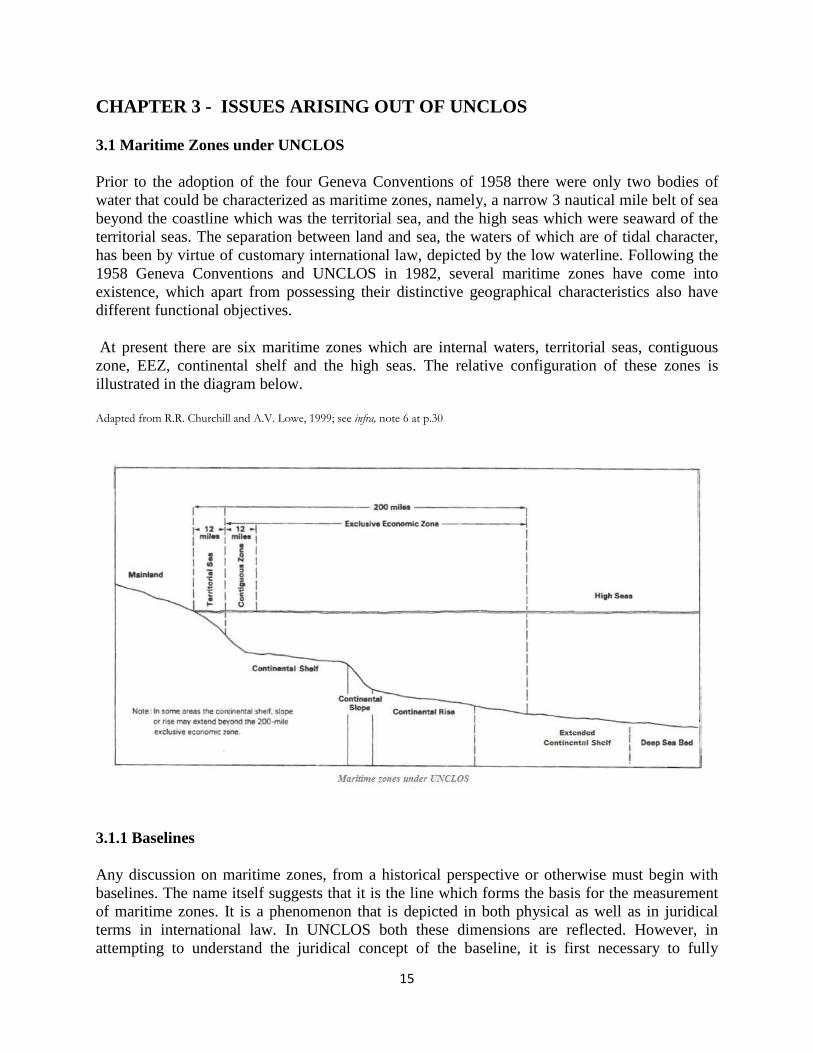
3.1 Maritime Zones under UNCLOS
Prior to the adoption of the four Geneva Conventions of 1958 there were only two bodies of water that could be characterized as maritime zones, namely, a narrow 3 nautical mile belt of sea beyond the coastline which was the territorial sea, and the high seas which were seaward of the territorial seas. The separation between land and sea, the waters of which are of tidal character, has been by virtue of customary international law, depicted by the low waterline. Following the 1958 Geneva Conventions and UNCLOS in 1982, several maritime zones have come into existence, which apart from possessing their distinctive geographical characteristics also have different functional objectives.
At present there are six maritime zones which are internal waters, territorial seas, contiguous zone, EEZ, continental shelf and the high seas. The relative configuration of these zones is illustrated in the diagram below.
Adapted from R.R. Churchill and A.V. Lowe, 1999; see infra, note 6 at p.30
3.1.1 Baselines
Any discussion on maritime zones, from a historical perspective or otherwise must begin with baselines. The name itself suggests that it is the line which forms the basis for the measurement of maritime zones. It is a phenomenon that is depicted in both physical as well as in juridical terms in international law. In UNCLOS both these dimensions are reflected. However, in attempting to understand the juridical concept of the baseline, it is first necessary to fully
16
appreciate the underlying scientific and physical phenomena. As mentioned above, prior to the Truman Proclamation of 1945 there was the singular concept of the territorial sea as a maritime zone of the coastal state. The high seas are not a coastal state maritime zone because they are available for the use of all states equally and without any right of occupation by any specific state. The baseline is described as the "territorial sea baseline" because it is the line from which the outer limit of the territorial sea is measured. As such, the rules relating to baselines are treated as being an integral part of the law associated with the territorial sea. In explaining and critiquing this notion, it has been stated that -
This was justifiable at the time when the territorial sea was the only zone of coastal state jurisdiction. But since the baseline is now used to measure not only the outer limit of the territorial sea but also the outer limit of the contiguous zone, the exclusive fishing zone and the EEZ, and in some circumstances the continental shelf, it no longer seems appropriate to consider baselines simply as part of the law relating to the territorial sea7
There are two varieties of baselines; the normal and the straight baseline, provided under UNCLOS. The former is based on the physical or scientific phenomenon of tidal variations while the latter is a juridical creation representing essentially a codification by treaty of a judicial pronouncement. In Article 5, the normal baseline is defined as "the low water line along the coast as marked on large scale charts officially recognized by the coastal state". The low water line depicts the so-called sinuosity of the coastline where the high water mark is further landward relative to the low water mark. It is obvious that the choice of the low water line as the normal baseline has given to the coastal state more territorial and zonal space. High and low water are tidal phenomena governed by the position of the sun and the moon relative to the earth at any given time. Notably, the force of gravitation exerted on the earth by the moon is far greater than that exerted by the sun because of the moon's proximity to the earth. Related to that scientific verity is the fact that the gravitational effect of a heavenly body is more pronounced on water than on land because of the fluidity of the former. Thus the revolution of the moon around the earth creates two instances of high and low water over a twenty-four period each occurring alternately every six hours. This is represented mathematically by a sine curve configuration from which the expression "sinuosity of the coastline" has emanated and is now entrenched in the legal literature on baselines.
.
It is noteworthy that high and low water marks are not fixed because the relative positions of the sun and moon vis a vis the earth are constantly changing. When the sun and moon are on the same side of the earth, the combined gravitational pull of the two heavenly bodies is highly amplified. The tides so created are known as spring tides. By contrast, when the sun and the moon are on opposite sides of the earth, their gravitational forces are partially neutralized and the combined effect is weaker. These are called neap tides. When the two heavenly bodies are at right angles to the position of the earth, the resulting tidal phenomena correspond to the relative intensities of the combined gravitational forces8
7 R.R. Churchill and A.V. Lowe, The Law of the Sea, 3rd. edition, Manchester: Juris Publishing, Manchester University Press, 1984 at p.1.
.
8T.G. Jones, Principles for Second Mates, 3rd Ed., Glasgow: Brown, Son & Ferguson Publishers, 1952 at pp. 230-235.
17
Given the natural phenomenon of tides resulting from the relative exertion of gravitational forces of the sun and moon on the earth, the use of the low water line in terms of legal application for the determination of the land-sea interface affords an obvious geographical advantage to the coastal state because in ordinary circumstances, that is what defines the baseline for the measurement of the outer limits of the territorial sea and other maritime zones.
However, certain natural coastline configurations are incompatible with the use of the low water line as the baseline. Indeed two such instances are identified in Article 7 paragraph 1 of UNCLOS which refers to "localities where the coastline is deeply indented and cut into"; in other words, is jagged in natural character, and where there is a "fringe of islands along the coast in its immediate vicinity"; in other words, the coastline is cluttered with numerous islands.9
Article 7 contains specific rules concerning straight baselines some of which include certain strictures and limitations. Special and particular situations are addressed such as high instability resulting from tidal phenomena, or the presence of a delta. Where a regression of the seaward extent of the low water line occurs subsequent to its establishment as the furthermost seaward line from the shore, the original straight baseline remains effective until the coastal state decides to alter it. It is not permissible to draw straight baselines that deviate too much from the general direction of the coastline. Only sea areas lying landward of the baseline that are closely linked to the land domain are recognized at law as internal waters.
In any or both such situations, the method of straight baselines joining appropriate base points can be applied under this Article instead of normal baselines. From these straight baselines, the outer extremities of the territorial sea and other maritime zones can be measured.
10 In Article 13, low tide elevations, otherwise referred to as "drying reefs" by seafarers, are defined as natural land features surrounded by water in such a way that they are visible at low tide but are submerged and therefore invisible when the tide is high. The drawing of straight baselines from or to such low tide elevations is prohibited unless there is a permanent structure such as a lighthouse built on it that is always above sea level. The rule is subject to an exception. Even if there is no such structure, it is permissible to utilize a low tide elevation if there has been demonstrable international recognition of the drawing of such baselines.11 Straight baselines are not permitted to be drawn in a way that has the effect of cutting off the territorial sea of another state from the high seas or an EEZ12
Pursuant to Article 9, the baseline across the mouth of a river that flows directly into the sea is a straight line between points on the low water line of the banks of the river. The line drawn across the mouth of a bay is known as a bay closing line. Under Article 10, it is determined by applying the "semi-circle rule" which provides that an indentation in the coastline is a juridical bay if the waters contained in it constitute an area at least as large as the area of a semi-circle generated by the diameter depicted by a line no longer than 24 nautical miles drawn across the mouth of the indentation. Notably, "historic bays" are not subject to the specific rules regarding juridical
.
9The application of straight baselines to jagged or deeply indented coastlines was first legally validated by the decision of the International Court of Justice in the Anglo-Norwegian Fisheries Case [1951] ICJ Rep. 116 10 See paragraphs 2 to 4 of Article 7. 11 See Article 13, paragraph 1 for definition of "low tide elevation" and Article 7, paragraph 4 for the rule 12 Article 7, paragraph 6.
18
bays13. There are also rules on the drawing of baselines relating to reefs, islands, artificial islands and archipelagoes14
3.1.2 Internal waters
.
The regime of internal waters is described in Article 8 of UNCLOS. It is a maritime zone of the coastal state and is defined in paragraph 1 as "waters on the landward side of the baseline of the territorial sea". The internal waters of a state are in essence assimilated to its land territory and therefore full territorial sovereignty applies to those waters in the same manner as it applies to the land territory itself. Article 2 in its first paragraph refers to the sovereignty of the coastal state extending beyond its "land territory and internal waters" which implies that the same sovereignty that applies to the land territory of a coastal state applies mutatis mutandis to its internal waters. The assertion and exercising of this sovereignty under international law is virtually without impediment. Thus the regime of internal waters has rarely featured in the law of the sea whether in terms of customary or convention law15
The outer extremities of sea ports are usually a part of the baselines of the coastal state. As such, the waters inside a port are internal waters, and therefore, in such waters the coastal state can exercise full sovereignty. Arguably, there is no inherent right of a foreign ship to enter a port; however, in the Aramco Arbitration of 1958 it was held that "[A]ccording to a great principle of public international law, the port of every state must be open to foreign vessels and can only be closed when the vital interests of the State so require."
.
16 Nevertheless, the predominant view is that under international law, any rights enjoyed by foreign vessels in this regard are not without limitations. In the Nicaragua case17 it was held that the internal waters of the state are subjected to that state's exercise of sovereignty and that it is "by virtue of its sovereignty that the coastal State may regulate access to its ports"18. There is, however, an exception in customary international law pursuant to which if a ship is in distress and human life on board is endangered it has a right to port entry19
The doctrine of sovereignty enables a coastal state to exercise virtually unlimited jurisdiction over ships in its internal waters. However, it will usually not assert jurisdiction over matters pertaining solely to the ship's internal matters unless it is requested to intervene by the master or diplomatic or consular authorities of the ship's flag state simply because the flag state's jurisdiction over its own ship continues to reign supreme regardless of where the ship is located at a given time. In criminal matters in particular, the coastal state will refrain from any intervention if the offence in question exclusively involves the "internal economy" of the ship.
.
20
13 See Article 10, paragraphs 2, 4, 5 and 6.
14 See Articles 6, 121, 11 and 47 respectively. 15 Supra note 7, at pp. 60-61. 16Aramco v. Saudi Arabia (1958) 27 ILR 117 61 at p.212. 17Nicaragua Case [1986] ICJ Rep.14. 18Ibid., at p.111. 19 See the cases of Creole (1853), Moore, Int. Arb 4375 63 and Kate A. Hoff (The Rebecca) (1929), IV RIAA 444 63 20 See D.R. Thomas, Maritime Liens; British Shipping Laws Vol. 14, London: Stevens & Sons, 1980 and supra note 7 at p.66.
19
But it will almost invariably assert jurisdiction if the peace, good order or security of the port or shore-based life is affected by the incident or the offence committed on board.21
Where there are international water courses such as the Rhine or Danube rivers which are internal waters of multiple states, no one particular state among them can exercise exclusive jurisdiction over those waters. These waterways are important for interstate commercial traffic and carriage of goods in terms of both unimodal as well as multimodal transportation. Any freedom of navigation exercised by foreign ships in these waterways is almost always subject to bilateral or multilateral arrangements entered into by the riparian states which have sovereignty over the waters.
3.1.3 Territorial sea
The territorial sea is in essence the seaward extension of a coastal state's land territory. The extremity of its outer limit is therefore a matter of considerable importance. Previously under customary international law emanating from state practice, the breadth of the territorial sea was 3 nautical miles. It was based on the so-called "cannon-shot" rule which exemplified the application of the doctrine of effective control and was closely associated with the notion of sovereignty. To assert sovereignty it was necessary for a littoral state to be able to demonstrate effective control over the belt of waters adjacent to the coast which it purported to claim as an extension of its land territory into the sea. The distance to which a cannon ball could be fired from the shore demonstrated the range of effective control over sea territory which a coastal state could exercise. In most countries, the reach of a cannon ball was 3 nautical miles which came to be defined as the breadth of the territorial sea except in the Scandinavian countries where pursuant to the cannon-shot rule it was established at 4 nautical miles.22
At the United Nations Conference held in 1958 at which the Convention on the Territorial Sea and the Contiguous Zone was adopted and the subsequent Conference held in 1960, the participating states failed to reach agreement on the breadth of the territorial sea.
23 Eventually it was established under UNCLOS at a maximum of 12 nautical miles from the baselines.24
It is significant that in the territorial sea, the sovereignty of the coastal state is inchoate or incomplete unlike the case of internal waters or the land domain. Under the customary international law as well as under UNCLOS, sovereignty in the territorial sea is subject to the right of innocent passage of foreign ships. Given that the territorial sea regime is different from the regime of internal waters in this particular aspect, the notion of "innocent passage" is immediately brought into focus for analytical examination. At the risk of repetition it must be emphasized that the concept is intimately associated with and is unique to the territorial sea regime; no other maritime zone provides for innocent passage of foreign ships. In UNCLOS, the concept consists of two components which are treated in detail. One is the issue of what is
It is undoubtedly a major achievement in this important and crucial branch of international law.
21Supra note 7, at pp. 66-67. 22David L. Larson et al., Major Issues in the Law of the Sea, Durham, N.H.: University of New Hampshire, 1976 at p. 32. 23 Ibid. 24See UNCLOS Article 3.

20
"passage" and the other is what constitutes "innocence" in relation to passage. The term "passage" is defined in Article18. Essentially passage must be "continuous and expeditious" but stopping and anchoring is included in passage if it is incidental to ordinary navigation. Exception is also made for force majeure or distress. The full text of Article 18 is as follows:
1. Passage means navigation through the territorial sea for the purpose of:
(a) traversing that sea without entering internal waters or calling at a roadstead or port facility outside internal waters; or
(b) proceeding to or from internal waters or a call at such roadstead or port facility.
2. Passage shall be continuous and expeditious. However, passage includes stopping and anchoring, but only in so far as the same are incidental to ordinary navigation or are rendered necessary by force majeure or distress or for the purpose of rendering assistance to persons, ships or aircraft in danger or distress.
It may be contended that the above-noted text is somewhat anomalous and obscure. What is seemingly a positive statement of law is tempered by exceptions in almost the same breath leading to potential ambiguity or insufficient clarity. In paragraph 1 it is mentioned that to qualify as "passage" the ship must conduct navigation through the territorial sea "without entering internal waters or calling at a roadstead or port facility outside internal waters". While under the second paragraph, passage must be "continuous and expeditious", a number of exceptions are made immediately thereafter by allowing for stopping and anchoring if such actions are incidental to ordinary navigation and for force majeure or distress of the ship or for giving assistance to another ship in a similar situation. The first exception begs the question as to what exactly is "incidental to ordinary navigation" which presumably must be determined by applying an objective test. Admittedly, however, the exception made for force majeure or distress is reasonable and justifiable in view of its obvious humanitarian objective.
The meaning of "innocent" in the context of passage is dealt with in Article19. The fundamental premise is that passage is considered to be innocent only to the extent that "it is not prejudicial to the peace, good order or security of the coastal state". This is provided in paragraph 1. In paragraph 2 twelve items are specifically mentioned as activities that are not considered to be innocent and are therefore prohibited. These are identified activities that are likely to prejudice the peace, good order or security to the coastal. They are as follows:
(a) any threat or use of force against the sovereignty, territorial integrity or political independence of the coastal State, or in any other manner in violation of the principles of international law embodies in the Charter of the United Nations;
(b) any exercise of practice with weapons of any kind;
(c) any act aimed at collecting information to the prejudice of the defence or security of the coastal State;
21
(d) any act of propaganda aimed at affecting the defence or security of the coastal State;
(e) the launching, landing or taking on board of any aircraft;
(f) the launching, landing or taking on board of any military devices;
(g) the loading or unloading of any commodity, currency or person contrary to the customs, fiscal, immigration or sanitary laws and regulations of the coastal State;
(h) any act of willful and serious pollution contrary to this Convention;
(i) any fishing activities;
(j) the carrying out of research or survey activities;
(k) any act aimed at interfering with any systems of communication or any other facilities or installations of the coastal State;
(l) any other activity not having a direct bearing on passage.
It is to be noted that warships are not categorically prohibited from exercising the right of innocent passage in the territorial sea. The prohibitions set out in Article19 paragraph 2 noted above specifically pertain to the carrying out of exercises or practice with weapons and activities involving aircraft or military devices.25 Also, pursuant to Article 20, underwater vehicles including submarines must engage only in surface navigation and must display their flags. Other activities that are not innocent for the purposes of Article 19 include the threat or use of force against the sovereignty, territorial integrity or political independence of the coastal state, any violation of the coastal state's customs, fiscal, immigration, or sanitary laws, any act of wilful and serious pollution, and fishing, research or survey activities.26
Under paragraph 1 of Article 21, the coastal state may enact legislation on innocent passage in respect of the following matters:
(a) the safety of navigation and the regulation of maritime traffic;
(b) the protection of navigational aids and facilities and other facilities or installations;
(c) the protection of cables and pipelines;
(d) the conservation of the living resources of the sea;
25 See sub-paragraphs 2 (b) (e) and (f) of Article 19. 26 See sub-paragraphs 2 (a), (g), (h), (i), and (j) of Article 19 as noted above.
22
(e) the prevention of infringement of the fisheries laws and regulations of the coastal State;
(f) the preservation of the environment of the coastal State and the prevention, reduction and control of pollution thereof;
(g) marine scientific research and hydrographic surveys;
(h) the prevention of infringement of the customs, fiscal, immigration or sanitary laws and regulations of the coastal State .
An important observation in paragraph 2 of this Article is that the legislation of the coastal state referred to above will not be applicable to the design, construction, manning and equipment of foreign vessels in excess of any requirements giving effect to international rules and standards. These would generally be rules and standards promulgated through the relevant IMO treaty instruments, namely SOLAS and its associated Codes, but may also include Classification Society rules in respect of a particular ship. This prohibition or limitation in UNCLOS Article 21, paragraph 2 is undoubtedly sensible. It would be totally unreasonable to expect a ship to make structural and equipment changes, not to mention change its crew complement requirements each time it sails into the territorial sea of a different country. A so-called "patchwork quilt" international regime for the enforcement of innocent passage laws of a coastal state is certainly not desirable.
Article 22 is another important feature of the territorial sea regime under UNCLOS. Under the Article, in the interests of navigational safety, the coastal state is empowered to establish sea lanes and traffic separation schemes in its territorial seas and may require foreign ships exercising their right of innocent passage to use them in accordance with prescriptions imposed by it. In particular, strictures may be placed on nuclear powered ships and ships carrying nuclear materials or tankers of sorts carrying dangerous or noxious substances.27 In designating sea lanes and traffic separation schemes and making prescriptions relating thereto, the coastal state must take account of IMO recommendations, use of particular channels customarily used in international navigation, particular ship characteristics and traffic density and must clearly indicate all relevant information mentioned above in nautical charts.28
Under Article 24, no coastal state is permitted to hamper the innocent passage of foreign ships through the promulgation and enforcement of laws which may have the practical effect of denying or curtailing a foreign ship's right of innocent passage through the territorial sea of a coastal state or discriminate in form or in fact against such ships or its cargoes.
The depiction of sea lanes and traffic separation schemes in nautical charts renders the information fixed and static which, arguably, may not always be conducive to navigational safety given that the master is the best judge of what is safe in relevant circumstances and the fact that navigation is a highly dynamic activity which requires flexibility rather than stricture in bridge operations.
29
27 Article 22, paragraphs 1 and 2.
There are certain measures provided for in Article 25 to protect the rights of a coastal state in the territorial
28 Article 22, paragraphs 3 and 4. 29 Article 24, paragraph 1 (a) and (b).
23
sea which include temporary suspension of innocent passage in specified areas in the territorial sea30
Pursuant to Articles 27 and 28, the coastal state is precluded from applying its criminal and civil jurisdictions against a foreign ship exercising innocent passage through its territorial seas. It is contextually notable that in relation to both the territorial sea as well as internal waters, the jurisdiction of the coastal state in relation to ships and acts committed from or within a ship may be subject to dual or concurrent jurisdiction. Thus, with respect to public law matters, the jurisdictions of the coastal state and flag state of the ship are not mutually exclusive. The ship in question or an individual belonging to the ship may be subjected to sanctions under the law of the coastal state for a particular violation and may also be punished under the flag state's laws. In effect there is no impediment of double jeopardy in this branch of international law as there is in the domestic laws of most jurisdictions.
.
It can be gleaned from the foregoing discussion focusing on the relevant Articles of UNCLOS that in the territorial sea, the coastal state enjoys a combination of both legislative as well as enforcement jurisdictions. The renowned authors Churchill and Lowe have this to say in this regard:
State practice and doctrine on the question of the extent of a coastal State's rights to enact legislation - its legislative, as opposed to its enforcement, jurisdiction - varied according to whether the territorial sea was regarded as a mere 'bundle of servitudes' or as a belt of maritime territory under the plenary jurisdiction of the State. The aim in all cases was to reconcile the right of innocent passage with the legitimate interests of the coastal States in the enforcement of their laws in the territorial sea31
3.1.4 Contiguous zone
.
The regime of the contiguous zone is contained in Article 33 of UNCLOS and is the only Article in the Convention which deals with this regime. Article 33 brings in the concept which was first codified and introduced in the 1958 Convention on the Territorial sea and Contiguous Zone and expresses its character in fairly clear and concise terms. It is described as a zone contiguous to the territorial sea32 which basically means that it is adjacent to it. But as a regime it is different from the territorial sea although closely connected to it as will be seen from the discussion below. It is evident that the jurisdiction of the coastal state under this regime covers four specific areas of law; namely, customs, fiscal, immigration and sanitary matters.33
30 Article 25, paragraph 3.
Customs laws address tariff restrictions and duties payable on imported items and issues of contraband and smuggling. Immigration laws deal with rights of entry and departure into the territory and territorial seas of the coastal state. Fiscal laws pertain to different kinds of taxation and may overlap or interface with customs laws. The term "sanitary" embraces multiple issues relating to health and hygienic practices of individuals extending to infectious and communicable diseases. This is referred to as
31 Supra note 7, at p. 92. 32 See paragraph 1 of Article 33. 33 Ibid. subparagraph (a).
24
"quarantine" or "pratique" in relation to shipping. It also deals with issues of shipboard cleanliness.
The most important feature of the contiguous zone in Article 33 is that the coastal state is given enforcement jurisdiction only. In other words, with respect to the enumerated subject matters, the coastal state has no legislative jurisdiction pertaining to that zone. Notably, it is the only provision in UNCLOS in which there is exclusive provision for enforcement jurisdiction alone. A close examination of Article 33 reveals that the enforcement powers of the coastal state in relation to the four specified subject matters pertain or correspond to the legislative jurisdiction of the state in its territory or territorial sea. It is in respect of the laws adopted for application in the territory and territorial sea that enforcement jurisdiction can be exercised in the contiguous zone. This is evident from the textual formulation in paragraph 1 of Article 33 which is as follows:
1. In a zone contiguous to its territorial sea, described as the contiguous zone, the coastal state may exercise the control (emphasis added by author) necessary to:
(a) prevent infringement of its customs, fiscal, immigration or sanitary laws and regulations within its territory or territorial sea;
(b) punish infringement of the above laws and regulations committed within its territory or territorial sea.
It is to be noted first that the use of the word "control" in the chapeau unequivocally signifies the notion of enforcement with regard to the jurisdiction exercisable by the coastal state. Second, the words "prevent" and "punish" in subparagraphs (a) and (b) respectively are also associated with enforcement. The word "prevent" bears the same connotation as "control", whereas "punish" reflects the corresponding sanction. The third observation is that the expressions "laws and regulations" and "within its territory or territorial sea" clearly indicate that the enforcement jurisdiction contemplated is in respect of the legislative jurisdiction of the coastal state in the territory and territorial seas. There is no mention of "laws and regulations" pertaining to the contiguous zone. The rationale for the provision of enforcement jurisdiction in the contiguous zone without any provision for legislative jurisdiction in that zone has been aptly explained as follows:
If legislative jurisdiction were to exist in the contiguous zone so that ships could commit offences there, they would be able to achieve a greater degree of immunity from coastal State jurisdiction by fleeing into the territorial sea than fleeing to the high seas or economic zone, since in the latter case they could be seized after hot pursuit34
The contiguous zone extends from the outer edge of the territorial sea to a maximum distance of 12 nautical miles, that is to say, its outer limit is at a maximum distance of 24 nautical miles from the territorial sea baseline
.
35
34 Supra note 7, at p.137.
.
35 See Article 33, paragraph 2.
25
A notable observation regarding the regime of the contiguous zone is in relation to Article 303 of UNCLOS where a cross-reference is made to Article 33. Article 303 deals with archaeological finds and historical objects at sea. It is provided in that Article that a coastal state, for the purpose of controlling trafficking in these things, has the right to apply Article 33 in connection with their removal from the seabed of the contiguous zone. Ordinarily this provision would point to the exercise of legislative jurisdiction in the contiguous zone but that is not quite the case. The combined text of paragraphs 1 and 2 of Article 303 is peculiar and obscure. Under the first paragraph there is a duty incumbent on all states to protect objects of an archaeological and historical nature. Pursuant to the second paragraph, "to control traffic in such objects, the coastal State may, in applying article 33, presume that their removal from the sea-bed in the zone referred to in that article without its approval would result in an infringement within its territory or territorial sea of the laws and regulations referred to in that article". The notion of the coastal state "presuming" that unauthorized removal is an infringement of its laws is manifestly dubious and unclear. What exactly the coastal state can presume in this regard that is of any contextual significance is left in doubt.
Article 303 could have provided in unequivocal terms that the coastal state may through national legislation expressly outlaw the removal of archaeological and historical objects; and if the law is violated, adopt appropriate enforcement measures under Article 33 to address the violation. Given that four specific areas of law are specified in Article 33, it is not clear under which of them would unlawful removal of archaeological and historical objects constitute an offence. It could possibly be contemplated as a customs offence but there may be fiscal implications as well. These uncertainties need to be addressed; clarifications are warranted. But it must also be recognized that UNCLOS cannot be easily amended at this juncture in the milieu of international law of the sea. In closing the discussion on the contiguous zone it can be said that there is both a zonal as well as a functional aspect to the regime. The geographical perimeter of the regime is circumscribed by its functional dimension in terms of the conspicuously exclusive enforcement jurisdiction of the contiguous zone. It is exemplified not only by the specific areas of law identified in Article 33 for enforcement but also the cross application of the Article to archaeological finds and historical objects under Article 303.
3.1.5 Exclusive economic zone
It is perhaps quite accurate to say that the exclusive economic zone (EEZ) is a creation of UNCLOS although it has evolved from what can be loosely described as regional custom. In universal terms it is a relatively new concept when compared with the other maritime zones. It did not exist under any of the 1958 Geneva Conventions. In UNCLOS, it is cast and identified as a specific legal regime although in some respects it straddles the continental shelf and the high seas. Its definition is found in Article 55 which reads as follows:
The exclusive economic zone is an area beyond and adjacent to the territorial sea, subject to the specific legal regime established in this Part, under which the rights and jurisdiction of the coastal State and the rights and freedoms of other States are governed by the relevant provisions of this Convention.
26
The zone is frequently described as "the 200 nautical mile EEZ" as if it is 200 nautical miles wide which is an imprecise statement. Contrary to this popular perception, the width of the EEZ is in reality 188 nautical miles as it starts from where the territorial sea ends although its outer limit is measured at 200 nautical miles from the territorial sea baseline. Article 57 providing that "[T]he the exclusive economic zone shall not extend beyond 200 nautical miles from the baselines from which the breadth of the territorial sea is measured" must be read in conjunction with the words "an area beyond and adjacent to the territorial sea" in Article 55 noted above for a clear understanding of the exact extent of the EEZ.
While the origins of the EEZ may appear to some to be veiled in relative obscurity, it is widely considered to be rooted in the Latin American concept of the patrimonial sea. It is interesting to note that conceptually the expression "patrimonial sea" is derived from the land territory being perceived as the "fatherland" or "land of the forefathers" in some national communities. The Truman Proclamation in 1945 is reputed to have provided the impetus for the evolution of the patrimonial sea concept at a time when there was a growing trend among coastal states of proliferating increasing control over the sea in an outward direction. This phenomenon had the effect of expanding coastal state jurisdiction and correspondingly diminishing the expanse and freedom of the high seas. Coastal state expansion initiatives included unilateral attempts at widening the territorial sea and establishing fishing zones36. Among Latin American states these initiatives found expression in the Declaration of Santo Domingo in June 197237. In this declaration the expression "patrimonial sea" was used for the first time. Prior to this event, Latin American proclamations had already been made, the objects of which were to establish a notion to which countries of the region subscribed. One was the Montevideo Declaration on the Law of the Sea, 1970 and another was the Lima Declaration on the Law of the Sea 197038
The concept of the EEZ and the articulation of the expression "exclusive economic zone" are attributable to a proposal made by Kenya first to the Asian-African Legal Consultative Committee in January 1971 and subsequently to the United Nations Sea Bed Committee in 1972. The proposal succeeded in garnering support from several African and Asian states which found it considerably attractive. These states actively supported the proposal internationally. It is widely accepted that the legal regime of the EEZ in UNCLOS is the result of the Kenyan proposal viewed in conjunction with the Latin American concept of the patrimonial sea. The proposed EEZ regime naturally found favour with the so-called "group of 77" states at the Third Law of the Sea Conference. The group comprising mainly the developing countries saw the new regime as being consistent with their national interests for economic development. Among important developed states, Canada and Norway enthusiastically embraced the new regime. Being endowed with significant deposits of oil and gas among other offshore marine resources, these states viewed the EEZ regime as being of immense potential benefit to their national economies
.
39
The adoption of the EEZ regime in UNCLOS is essentially the result of a compromise reached at the conference between two extreme positions taken by states. One group looked for a
.
36 Supra note 7, at p. 160. 37 UN Leg Ser B/16 p. 599 and ND I p. 247. 38UN Leg. Ser B/16 pp. 586 and 587; ND I, pp. 235 and 237. 39 Supra note 7, at p.30.
27
significantly wider territorial sea consistent with the patrimonial sea concept while the other, mainly representing developed states, adopted a relatively conservative stance. The latter were manifestly opposed to any expansion of coastal state sovereignty and jurisdiction that would result in an undesirable intrusion into the high seas40
Now that the EEZ is firmly established as a maritime zone in the international law of the sea, certain pertinent observations need to be made regarding its character as a legal regime and its functionality. First, a coastal state does not possess an inherent right to an EEZ under international law. It has to be claimed through some legal process such as enactment of national legislation or must otherwise be institutionalized and formalized by political declaration, proclamation or edict. Whereas a state is not obliged to have an EEZ, the corollary is that it cannot have one that is recognized internationally unless it expressly makes a claim to that effect.
.
41 Second, before the Third United Nations Law of the Sea Conference was convened, there was no EEZ under customary international law. However, during the currency of negotiations which lasted for a period of some nine years until the Convention was adopted in 1982, many states realizing the eventuality of the EEZ and perceiving the proposition to be of immense benefit to their national interests, took appropriate steps to unilaterally claim a zone stretching out to 200 nautical miles from their baselines and incorporated it into their national legal orders.42 It is therefore a reasonable contention that aside from its inclusion as a maritime zone under UNCLOS, it is also a regime under customary international law. As such, the need for express declaration or some other legislative or political action to enable a state to invoke rights under it may be superfluous. Third, the EEZ is said to be a regime sui generis. It is neither a seaward extension of the territorial sea nor a landward encroachment of the high seas. It is recognized, however, that in view of three of the six freedoms of the high seas applying within the EEZ, namely, the freedoms of navigation, overflight and laying of submarine cables and pipelines, some confusion arises prompting an unwarranted contention that the superjacent waters constitute the high seas43. Fourth, the EEZ is embellished with two important attributes; one is the notion of sovereign rights over natural resources and the other is jurisdiction over three identified subject matters44
Article 56(1)(a) of UNCLOS provides as follows:
. These are discussed in relative detail below.
In the exclusive economic zone the coastal state has -
(a) sovereign rights for the purposes of exploring and exploiting, conserving and managing the natural resources, whether living or non-living, of the waters superjacent to the sea-bed and of the sea-bed and its subsoil, and with regard to other activities for the economic exploitation and exploration of the zone, such as the production of energy from the water, currents and winds;
40Ibid., at p. 153. 41 An alternative view is expressed by Churchill and Lowe that "[U]nder the convention there is no obligation on a state to claim an EEZ". The authors have identified several states which have expressly made such claims. See supra note 7 at p. 161. 42 See Ibid. 43See paragraph 1 of Article 51 and its cross-reference to Article 87. 44Article 56, paragraph 1 (a).
28
In the above provision, several points must be carefully noted. The first point of observation is that in the EEZ the coastal state possesses "sovereign rights" as distinguished from "sovereignty". Although in ordinary parlance and under the general public international law, such rights are an integral part of the doctrine of sovereignty, in terms of UNCLOS, the concept resides at a relatively lower threshold. Whereas the coastal state enjoys complete sovereignty on land and in internal waters, it is constrained by a foreign ship's right of innocent passage in the territorial sea. In the EEZ, it only enjoys sovereign rights, a concept created by UNCLOS and consciously cast at a level lower than that of sovereignty. The distinction between "sovereignty" and "sovereign rights" is thus significant and the expression "sovereign rights" is not to be construed in the general sense of international law as an element of sovereignty per se.
Associated with the foregoing discussion is the second important point that the sovereign rights in the EEZ are over natural resources only; in other words, non-natural objects such as wrecks of ships or property abandoned at sea do not fall within the purview of these rights of the coastal state. The remains of the Titanic, therefore, would not qualify as natural resources. Sovereign rights pertain to exploration, exploitation, conservation and management of natural resources whether they are living or non-living; in other words, the rights apply to, for example, fisheries, sea animals and flora and fauna which are living resources and also to hydrocarbons such as oil and gas, and other minerals which are resources of the non-living variety.
The third point that needs to be emphasized is that the aim of the regime is to advance the economic position of the coastal state by affording it more sea space beyond the territorial sea. The "economic" object of the regime is clearly reflected in the use of that word in the description of the zone. It is contemplated in conceptual as well as in practical terms that the functional utilization of the zone primarily consists of economic activities such as exploitation and exploration of natural resources and production of energy from the sea including energy derived from tidal forces, wind and currents45
The fourth point to be noted is that there is a vertical as well as a horizontal or lateral dimension to the physical configuration of the EEZ regime. The water column or the superjacent waters lying above the seabed and subsoil is the vertical component of the zone. The seabed and subsoil which stretches out seawards represents the horizontal component although it is also true that the superjacent waters have a lateral dimension as well which is circumscribed by the 200 nautical mile outer limit of the zone. In this context, it must be further noted that the sovereign rights over natural resources of the coastal state under the EEZ regime overlaps with the continental shelf regime. Thus, as far as the seabed and subsoil is concerned, there is a duality of regimes up to the 200 nautical mile limit.
.
Having elaborated on the issue of sovereign rights, it is necessary to discuss the second attribute of the EEZ regime, namely, the issue of jurisdiction. This is set out in subparagraph (b) of Article 56(1) which provides as follows:
In the exclusive economic zone, the coastal state has -
45Proshanto K. Mukherjee, Maritime Zones and Boundaries, Malmo: WMU Publications, 2000 at pp.9-14.
29
...
(b) jurisdiction as provided for in the relevant provisions of this Convention with regard to:
(i) the establishment and use of artificial islands, installations and structures;
(ii) marine scientific research;
(iii) the protection and preservation of the marine environment;
It is to be noted that the right to establish and use artificial islands, installations and structures in the EEZ is contained in Article 60, paragraph 146. The jurisdiction over these objects is exclusive and is provided for in paragraph 2 of this Article. As such, provision of jurisdiction in respect of these objects in Article 56 (1)(b) would seem to be an unnecessary duplication. Be that as it may, the items mentioned in subparagraphs (b)(ii) and (iii) in terms of the coastal state's jurisdiction over those matters are of considerable importance. These are marine scientific research (MSR) which presumably includes hydrographic surveys, and protection and preservation of the marine environment. In respect of the latter, the jurisdiction pertains to marine pollution from all sources, namely, land-based, ship-source and the seabed. These two subject matters as legal regimes under UNCLOS are addressed in detail in Parts XIII and XII respectively. It is also noteworthy in the context of the coastal state's enforcement jurisdiction in the contiguous zone discussed earlier, that in the EEZ, the coastal state enjoys exclusive jurisdiction in relation to its customs, fiscal, health, safety and immigration laws47
3.1.6 Continental shelf
. It would appear that the jurisdiction in this regard is both legislative as well as enforcement.
The Truman Proclamation of 1945 is considered to be the genesis of the continental shelf doctrine in international law. It is notable that this event pre-dated the Geneva Convention on the Continental Shelf of 1958 which was undoubtedly influenced by the unilateral American action in this regard. In 1945, Harry Truman, who was the incumbent President of the United States at that time made a formal proclamation that-
... the natural resources of the subsoil and seabed of the continental shelf beneath the high seas but contiguous to the coasts of the United States as appertaining to the United States, subject to its jurisdiction and control.48
In geological terms, the continental shelf is generally described as the natural prolongation of the continental land mass. Marine scientists distinguish between features that are oceanic in
46 The subject of artificial islands, installations and structures pertains as well to the regimes of the continental shelf and the high seas. 47Article 60, paragraph 2. 48 See ND I, p. 106; see also Ann Hollick, "US Oceans Policy: the Truman Proclamation", (1976-77), 17 VJIL pp. 23-25.
30
character and those that are identified as continental. For example, sea mounts and other geological elevations in the seas are essentially oceanic features. By contrast, the continental shelf is a natural extension of the land under the sea that is not ordinarily visible from the shore because it is submerged. In more precise geological terms, what is loosely known as the continental shelf actually comprises three identifiable elements in a singular configuration. The near-shore element is the shelf which is relatively flat and has the appearance of a shelf in ordinary parlance. The flatness of the feature then assumes a downward gradient comprising the element known as the slope. Further in the configuration the slope moves naturally upwards and is known as the rise. The combination of the three elements is referred to as the continental margin. Depending on the seaward extent of the whole configuration, a continental margin may be described as wide or narrow and a state may be described as a wide or narrow margin state. However, a state may have both a wide and a narrow margin in different parts or sides of its continental land mass. For example, Canada has a wide margin on its eastern extremity but a narrow margin on its western side.
From the perspective of international law of the sea it is important to appreciate that the continental shelf regime is an expression of geological phenomena represented as a juridical precept. In UNCLOS this is manifested in the first segments of paragraphs 1 and 3 of Article 76. In paragraph 1 it is provided that-
The continental shelf of a coastal State comprises the seabed and subsoil of the submarine areas that extend beyond its territorial sea throughout the natural prolongation of its land territory to the outer edge of the continental margin, ...
In paragraph 3 the general description is detailed out as follows:
The continental margin comprises the submerged prolongation of the land mass of the coastal State, and consists of the seabed and subsoil of the shelf, the slope and the rise49
Further to the above, the second segment of paragraph 1 provides that in the first instance the continental shelf extends-
.
to a distance of 200 nautical miles from the baselines ...where the outer edge of the continental margin does not extend up to that distance.
What this means is that whereas the geological dimension essentially consists of a natural phenomenon the juridical dimension is somewhat fictional or artificial since the outer limit is fixed arbitrarily by the convention at 200 nautical miles in the case of a geologically narrow margin. The significance of the continental shelf regime under UNCLOS thus lies in a full and unequivocal appreciation of its geological and juridical dimensions as portrayed in the relevant provisions of Article 76. In essence, the combination of the two concepts is what defines the regime of the continental shelf50
49See diagrammatic depiction of maritime zones at p. 2 above.
.
50Proshanto K. Mukherjee, Maritime Zone and Boundaries, Malmo: WMU Publications, 2000 at p.11.
31
The second segment of paragraph 3, in relation to the elaboration of what constitutes the continental margin, provides that-
[I]t does not include the deep ocean floor with its oceanic ridges or the subsoil thereof.
This express statement in essence precludes oceanic features from the definition of the continental shelf in terms of its seaward extension. An oblique distinction is thus made between continental and oceanic features in scientific terms and is reconciled with the juridical definition of the continental shelf51
The unilateral delimitation of the outward extent of the continental shelf as a legal regime has been considerably problematic and continues to raise questions on how accurately can it be determined in accordance with the prescriptions provided in Article 76 of UNCLOS. In the Continental Shelf Convention of 1958 the outer limit is expressed to extend in the first instance to the 200-metre isobath
. Incidentally, where the end of the continental shelf meets the beginning of the deep ocean floor or its subsoil, otherwise known as the abyssal plain in scientific terms, is where hydrocarbon resources are in abundance.
52 and in the second instance, beyond that limit to a distance where the depth admits of exploitation of the natural resources in those waters. Notably, the International Court of Justice in the North Sea Continental Shelf 53cases endorsed that definition and stated that it represented customary international law; but the court also emphasized the theory of the natural prolongation of the continental land mass. Even though several states embraced that definition of the outer limit and incorporated it in national legislation, there was also opinion to the effect that the prescription was not without difficulties. It was realized that the 200-metre isobath would not suit wide margin states which prompted the introduction of the "limit of exploitability" criterion. It was also recognized that the effective application of it would depend much on how much the relevant technology was developed and available to enable coastal states to take advantage of it.54 Arguably, the "limit of exploitability" criterion could stretch the Canadian continental shelf on its eastern seaboard across the Atlantic Ocean to the coastal zone of Ireland and there could be the same effect in reverse with regard to the Irish continental shelf. The issue was debated extensively at the Third United Nations Conference on the Law of the Sea which eventually led to a new continental shelf regime quite different from the 1958 Convention in terms of the fixing of the outer limit. Despite lingering problems with a clear understanding of the complexity of Article 76 of UNCLOS, the prescription is generally considered to be equitable and compatible with the concerns of both narrow margin and wide margin states.55
51See Robert W. Smith and George Taft, "Legal Aspects of the Continental Shelf" in Peter J. Cook and Chris M. Carleton, Continental Shelf Limits: The Scientific and Legal Interface, U.S.A.: Oxford University Press, 2000 at p. 19 and "History of the Ocean" visited on http://marinebio.org/oceans/history/ last visited on 23 October 2012
52The line of equal "bathymetry", which is the scientific term for "depth" or the nautical term "sounding", is referred to as the “isobath”. See A Manual on Technical Aspects of the United Nations Convention on the Law of the sea 1982, Special Publication No.51, Monaco: IHO Publishing, 1993 at p. 18 where “isobath” is defined as “a line representing the horizontal contour of the sea-bed at a given depth”. 53 [1969] ICJ Rep. 253. 54 David L. Larson, et al., Major Issues in the Law of the Sea, Durham, N.H.: University of New Hampshire, 1976 at pp. 58-61. See also supra note 7, at p. 147. 55 Supra note 7, at pp.147-150.
32
In a narrow margin state, or the narrow margin side of a state, where the geological continental shelf is less than 200 nautical miles from the baseline, under paragraph 1 of Article 76, the coastal state is entitled to a maximum outer limit of 200 nautical miles from the baseline. Clearly, this determination of the outer limit is a juridical creation of the Convention without consideration of the geological reality of the situation except that it recognizes the continental shelf as being geologically narrow. When it comes to the determination of the outer limit of a wide margin state, the matter is far more complex. There are options provided in paragraph 4 of Article 76; a state will obviously choose the option which is most advantageous to its interests. Paragraph 4(a) reads as follows:
4. (a) For the purposes of this Convention, the coastal State shall establish the outer edge of the continental margin wherever the margin extends beyond 200 nautical miles from the baselines from which the breadth of the territorial sea is measured, by either:
(i) a line delineated in accordance with paragraph 7 by reference to the outermost fixed points at each of which the thickness of sedimentary rocks is at least 1 per cent of the shortest distance from such point to the foot of the continental slope; or
(ii) a line delineated in accordance with paragraph 7 by reference to fixed points not more than 60 nautical miles from the foot of the continental slope.
It is evident from the above prescription, generally referred to as the "Irish formula", that the limit is a choice between a line connecting points not more than sixty miles apart at each of which points the thickness of sedimentary rocks is at least one percent of the shortest distance from such point to the foot of continental slope, or a line connecting points not more than sixty miles apart, which points are no more than sixty miles from the foot of the slope.56
It should be noted at this juncture that paragraph 7 of Article 76 to which a cross-reference is made in subparagraphs (i) and (ii) of paragraph 4(a) provides that "the delineation of the outer limit shall be by straight lines not exceeding sixty nautical miles in length connecting fixed points identified by geographical co-ordinates". No doubt, this adds to the complexity of the Irish formula.
Furthermore, the options available in paragraph 4 are subject to certain limitations prescribed in paragraph 5 which also comprise options in themselves. According to this paragraph, the outer limits calculated under paragraph 4(a) must not exceed either 350 nautical miles measured from the baselines, or 100 nautical miles from the 2,500-metre isobath. It would appear from this provision that regardless of the option chosen under paragraph 4(a), the choice is tempered by a maximum limit of 350 nautical miles from the baseline or 100 nautical miles from the 2,500-metre isobath. It is submitted, however, that these limits which appear to be maximum are in fact not absolute. Attention must be drawn to the content of paragraph 6 which starts with the words "Notwithstanding the provisions of paragraph 5" signifying that an exception is forthcoming in the form of an overriding clause. Paragraph 6 continues as follows: 56As explained by the authors Churchill and Lowe in supra note 7, at pp. 148-149.

33
...on submarine ridges the outer limit of the continental shelf shall not exceed 350 nautical miles from the baselines from which the breadth of the territorial sea is measured. This paragraph does not apply to submarine elevations that are natural components of the continental margin, such as its plateaux, rises, caps, banks and spurs.
The convolution is "spurred" by exceptions to exceptions. Under the first sentence in paragraph 6, where there are submarine ridges on the outer continental shelf, it would appear that only the 350-nautical mile limitation of paragraph 4(a) is available even if the 2,500-metre isobath option may be more advantageous. However, under the second sentence of that paragraph, the 350-nautical mile limitation is not applicable to submarine elevations (as distinguished from ridges) which are natural components of the continental margin and examples of which are given in the provision. The question arises as to what exactly is the limitation for such features in respect of which paragraph 6 seemingly does not apply. The assumption must be that we are back to applying paragraph 5. On the whole the draft of these provisions of Article 76 is not exactly a model of clarity.
Aside from the issue of diction and linguistic comprehension, there are also uncertainties in the Irish formula from a scientific viewpoint. Changes may occur or may at least be contemplated in respect of the configuration of the seabed. Apparently, bathymetric information is inadequate to enable precise determination of the location of the 2,500-metre isobath, and in geological terms, it is not easy to accurately determine the thickness of sedimentary rocks.57
In addition to the above examples of lack of certainty, it is also alleged that it is virtually impossible to precisely locate the foot of the continental slope which can stretch over a considerably long distance or occupy a large area of the sea bottom. In this context subparagraph (b) of paragraph 4 provides that "[I]n the absence of evidence to the contrary, the foot of the continental slope shall be determined as the point of maximum change in the gradient at its base". It is important for wide margin states to be able to precisely determine where the foot of the slope lies in the extended continental shelf because, as mentioned earlier, that is where off-shore hydrocarbon resources are located. Contrary to allegations of uncertainties in this regard, some scientific developments appear to indicate that indeed it is possible to identify the foot of the slope in a fairly precise manner given the current advancements in geological and geo-morphological science and technology.
The task of establishing the outer limits of the continental shelf in accordance with the prescription given in Article 76 of UNCLOS may thus appear to be quite daunting.
58
Before the limits of the outer continental shelf can be fixed, the relevant information assembled by the coastal state in line with the prescriptions provided in Article 76 must be submitted to the Commission on the Limits of the Continental Shelf pursuant to paragraph 8 of that Article. The Commission, established under Annex II of UNCLOS will make certain recommendations
57Ibid., at p.149; see also P.A.Verlaan, “New seafloor mapping technology and article 76 of the United Nations. Convention on the Law of the Sea”, (1997), 21 Marine Policy pp. 425-434. 58See e.g.,Vaughan Stagpoole, et al, “Foot of the Continental Slope in Article 76”, Institute of Geological & Nuclear Sciences, Lower Hutt: New Zealand, at p.4 www.gmat.unsw.edu. au/ablos/.../PAPER2-1.PDF, visited on 28 March 2012.
34
relating to the matter on the basis of which the coastal state must establish the outer limit which will then become final and binding.
The continental shelf and the EEZ have common characteristics as legal regimes. As well, there is a physical overlap between them as two maritime zones. There are also differences. The EEZ comprises the sea-bed and subsoil and also the superjacent waters in a vertical configuration. By contrast, the continental shelf only consists of the bottom, namely, the sea-bed and subsoil but not the water column. As such, the seabed and subsoil underlying the sea from the outer limit of the territorial sea to the distance of 200 nautical miles from the baseline belong to both the EEZ as well as the continental shelf. With regard to the unity of character as two legal regimes, it is significant that in both zones, the coastal state possesses sovereign rights over the natural resources and is entitled to explore and exploit them freely in accordance with its domestic policies. The sovereign rights are exclusive in the sense that even if the resources remain unexplored or unexploited, no other state can undertake any activities impinging on the coastal state's rights without its express consent.59
With regard to the continental shelf, it is notable that aside from the non-living resources which are mainly minerals including oil and gas, there are the living resources which are primarily organisms belonging to the sedentary species such as lobsters, crabs and the like. The term "sedentary species" is defined as "organisms which, at the harvestable stage, either are immobile on or under the seabed or are unable to move except in constant physical contact with the seabed or the subsoil".
One important distinction between the two zones as legal regimes is that the continental shelf is an inherent right in international law attributable to the Truman Proclamation being transformed into customary international law and the natural prolongation doctrine. As provided in paragraph 3 of Article 77, the rights "do not depend on occupation, effective or notional, or on any express proclamation". By contrast, as mentioned earlier, the EEZ must be claimed through some formal process.
60 In this regard it must be observed that even though the rights over the seabed and subsoil including the living resources therein are common to both the EEZ and the continental shelf regimes, paragraph 3 of Article 56 provides in essence that in so far as those rights fall under the EEZ regime, they are to be exercised in accordance with Part VI of UNCLOS. This is the Part that provides for the continental shelf regime. In that context it must be observed that the coastal state's rights over the sedentary species extend to the outer continental shelf. Given that the EEZ ends at the 200-nautical mile limit, beyond that limit, a wide margin coastal state continues to enjoy the rights pertaining to the extended continental shelf provided for in Articles 76, 77, 80 and 81.61 In other words, the rights of the coastal state apply in the extended continental shelf in the same manner provided for in Article 77 as in the shelf within 200 nautical miles of the baselines but with some exceptions. In respect of the extended continental shelf the coastal state must make payments or contributions in kind in respect of the exploitation of non-living resources62
59Article 77, paragraph 1 and 2.
, but if the state is a developing country and
60Article 77, paragraph 4. 61 Note that Articles 80 and 81 relate to artificial islands, installations and structures and drilling on the continental shelf which is an exclusive right. 62 Article 82, paragraph 1.
35
is a net importer of the mineral resources extracted from its own continental shelf, it is not required to make any payments or contributions63
3.1.7 High seas
.
It must be appreciated that the high seas do not constitute a maritime zone of the coastal state. They belong to all states collectively. However, the high seas are of crucial significance to the rights of coastal states and the jurisdiction they can exercise. The regime of the high seas under UNCLOS is based on the doctrine of mare liberum enunciated by Hugo Grotius and also derived from the Roman law doctrine of res communis64
There are a number of provisions in Part VII which pertain to shipping. The inclusion of these provisions in Part VII is rationalized on the premise that ships are mostly to be found on the high seas where they fall under the virtually exclusive jurisdiction of the flag state. Although the assumption that ships, for the most part are situated on the high seas is somewhat dubious, the relevant provisions are important from the viewpoint of shipping and appreciation of the interfaces between public international law and the regulatory and administrative laws of shipping. Articles 91, 92 and 94 relate to the subjects of ship nationality including the role of the doctrine of genuine link which is presented in a somewhat inchoate fashion. Some are of the view that the last sentence in Article 91 stating that "[T]here must exist a genuine link between the State and the ship", is an isolated statement and no definition of "genuine link" is provided. But Article 94, paragraph 1 throws some light on this issue through the provision "[E]very State shall effectively exercise its jurisdiction and control in administrative, technical and social matters over ships flying its flag." Article 92 deals with the legal notion of the flag and the role and status of the flag state including its exclusive jurisdiction in the high seas over ships flying its flag. Dual nationality and by extension dual flagging is prohibited under this Article. Under subparagraph 2(a) of Article 94 states are required to maintain a register of ships flying its flag. This provision indicates that registration is the procedural and administrative mechanism through which nationality is conferred on a ship; and since dual nationality is prohibited under Article 92, it stands to reason that dual registration of a ship is also contrary to international law.
. In UNCLOS the high seas regime is addressed in Part VII. In Article 87, six freedoms of the high seas are enumerated. These are navigation, overflight, laying of submarine cables and pipelines, construction of artificial islands and installations, fishing and scientific research. Article 88 expressly provides for the high seas to be reserved for peaceful purposes.
Articles 101 to 108 deal with the topical issue of high seas piracy which is considered to be a jus cogens crime; in other words, a crime against a peremptory norm of international law65
63Article 82, paragraph 3.
. In respect of piracy, universal jurisdiction is applicable which means all states have the right to take action and the duty to cooperate in the repression of this heinous crime. Ordinarily, aside from action against piracy, the coastal state has no jurisdiction in the high seas except where the
64 See supra note 7, at pp. 143 and 225. 65 See Max Mejia Jr. and P.K. Mukherjee, "The SUA Convention, 2005: A Critical Evaluation of its Effectiveness in Suppressing Maritime Criminal Acts", (2006), JIML, Vol. 12. No. 3 at p. 184. See also M.C. Bassiouni, "The Sources and Content of International Criminal Law: A Theoretical Framework" in M.C. Bassiouni (ed.), International Criminal Law, Ardsley, N.Y.: Transnational Publishers, 1999, at pp. 38-46.
36
doctrine of hot pursuit is applicable under Article 111 and under the Intervention Convention of 1969 which speaks of the coastal state's right to intervene on the high sea in cases of imminent threat of pollution damage to its coastline or coastal interests66
Although it constitutes a separate regime, the law governing the seabed, ocean floor and their subsoil, otherwise known as the "Area"
.
67, is found in Part XI of UNCLOS. It is relevant to the high seas because it underlies the water column and is also subject to the doctrine of res communis now tempered by the doctrine of "common heritage of mankind"68. Also, the freedoms of the high seas referred to in subparagraphs (c), (d), (e) and (f) naturally pertain to the Area as defined in UNCLOS69
3.1.8 Freedom of navigation in the EEZ and the high seas
.
Since ancient times up until the present modern age, the sea and its uses have gained increasing importance in everyday life. The significance of the seas in various respects continues to grow as trade and commerce flourishes across the globe and related seaborne activities and occupations face new challenges in a changing economic, social and technological world not to mention the detrimental effects of marine pollution and other menaces such as piracy and unlawful acts at sea. The functional approach of UNCLOS reflects the international maritime community's multifarious interests tied to the seas and its bounties. As mentioned earlier, one of the primary concerns of the new law of the sea is to provide for “rights and obligations of States regarding the use, management, and control of ocean space...”70
[T]wo principles have governed the law of the sea since early times when sailors and fishermen first ventured into the sea: the right of the coastal state to control a narrow strip along the coast, and the freedoms of navigation and fishing in the high seas beyond that coastal area
In this context it has been pointed out by the eminent Judge Thomas A. Mensah citing the words of Louis B. Sohn acclaimed as one of the fathers of the modern international law of the sea, that-
71
Fishing is one of two sea uses or functions alluded to above. The other function is navigation with which this section of the Report is concerned. It is submitted that navigation is and always has been the most important and significant of sea uses. Shipping is the primary means of global transportation and seaborne trade is considered to be the lifeblood of every nation to which marine navigation is intimately connected. All coastal states have an interest in navigation not only for trade and commerce reasons but also the associated concerns over maritime safety and security and the protection of their coastlines and coastal and hinterland interests as matters of priority ranking high on their national policy agendas. No doubt, states consider themselves duty
.
66 International Convention Relating to Intervention on the High Seas in Cases of Oil Pollution Casualties (Intervention), 1969; note Article 221 of UNCLOS which alludes to the substance of the Intervention Convention without any specific mention of it. 67 Defined in Article 1, paragraph 1(1) of UNCLOS. 68 Article 136 of UNCLOS. 69 These are the freedoms to lay submarine cables and pipelines, to construct artificial islands and other installations, to engage in fishing and to carry out marine scientific research. 70 Thomas A. Mensah, Preface to Donald R. Rothwell and Sam Bateman (eds.) Navigational Rights and Freedoms and the New Law of the Sea, The Hague/ London/ Boston : Martinus Nijhoff Publishers, 2000 at p.vii. 71 Ibid.
37
bound to protect their citizens and residents from attacks emanating from the sea and to provide security measures along their coasts and seaways. Navigational safety and security is as much a matter of concern as the corresponding concept of freedom of navigation embedded in the international law of the sea since Grotius and his doctrine of mare liberum which became firmly established as the cornerstone of that law.
Yet in terms of the codification of the customary law of the sea first through the Geneva Conventions of 1958 and subsequently through UNCLOS, it is alleged that shipping has not been accorded the attention and status it deserves although public law rules pertaining to navigational rights and responsibilities have been addressed. The illustrious Professor Edgar Gold has stated that-
... The new law of the sea has in the past decade addressed itself to all areas of ocean use except the one that since before the dawn of history, has been preeminent - the use of the ocean as a means to transport people and their goods from place to place on this planet, so much more of which is water than is land. Marine transport has been discussed in an almost abstract manner, as if it did not fit or belong within the public domain but needed to be confined to the more "private" region of international commerce, which was considered to be outside the scope of the law of the sea72
In referring to the artificial bifurcation between public and private maritime law in respect of navigation and shipping and in support of Professor Gold's comment, it has been stated that it-
.
is not entirely the product of narrow private law perceptions of maritime law, nor necessarily, of the inherent biases of the commercial world. It is evidently as much a product of perceived superiority of public power73
Against the above background, it is recognized that navigation is inherently a part of shipping and is probably the most important sea use dating from ancient times long before the eras of power-driven vessels and even sailing ships. It is well documented that ancient maritime civilizations such as those of the Egyptians, Phoenicians and Greeks, oars were the main means of ship propulsion even in distant voyages. In the following text the role of navigation as a major function in the various maritime zones of a coastal state as depicted in UNCLOS is discussed.
.
3.1.9 Rights in archipelagic sea lanes
“Archipelagic waters” is a new and special maritime zone which pertains only to archipelagic states such as The Philippines and Indonesia. The term “archipelagic waters” is a creation of UNCLOS. During the negotiations at the Third U.N. Conference on the Law of the Sea, two alternative approaches were discussed. One view was to design a special navigational regime for archipelagic waters. This view, mainly espoused by the archipelagic states, was to treat the waters in an archipelagic system as a part of the regime of internal waters so that no right of innocent passage for foreign ships would exist as in the territorial seas. The other viewpoint was 72 Edgar Gold, Maritime Transport: The Evolution of International Marine Policy and Shipping Law, Toronto: Lexington Books, 1981, Introduction at p. xix. 73 Proshanto K. Mukherjee, Maritime Legislation, Malmö: WMU Publications, 2002 at p. 2.

38
that archipelagic waters should be treated as a part of the EEZ. The rights of the archipelagic state in those waters would be limited to rights to explore and exploit the natural resources while the rights of navigation in those waters would be open to all states as in the high seas. Following extensive negotiations at the Conference, a compromise was reached pursuant to which a new maritime zone was created - the regime of archipelagic waters. Under this regime, in archipelagic waters, there is no right of any passage in the internal waters but there is a right of innocent passage in archipelagic waters outside the internal waters. Also, there is a right of innocent passage in the territorial seas around the archipelagic waters. There are archipelagic sea lanes (ASL) specially designated within the archipelagic waters in which there is a right of archipelagic sea lanes passage(ASLP)74
As mentioned earlier, a foreign ship enjoys the right of innocent passage through the territorial seas as well as the archipelagic waters of an archipelagic state. However, if the territorial seas of an archipelagic state are adjacent to archipelagic sea lanes or the EEZ, the right of innocent passage may be temporarily suspended and the right of archipelagic sea lane passage may apply instead as indicated below:
.
The archipelagic state may, without discrimination in form or in fact among foreign ships, suspend temporarily in specified areas of its archipelagic waters the innocent passage of foreign ships if such suspension is essential for the protection of its security75
Article 53 is a comprehensive Article dealing with the concept of archipelagic sea lane passage. It provides for the designation of archipelagic sea lanes for the continuous and expeditious passage of foreign ships and the right of foreign ships to conduct such passage
.
76
In this regime, activities such as fishing, marine scientific research are not considered to be continuous, expeditious and unobstructed passage through archipelagic sea lanes. The definition of archipelagic sea lanes passage is provided in Article 53 of UNCLOS as follows:
.
"Archipelagic sea lanes passage" means the exercise in accordance with this Convention of the rights of navigation and overflight in the normal mode solely for the purpose of continuous, expeditious and unobstructed transit between one part of the high seas or an exclusive economic zone and another part of the high seas or an exclusive economic zone.
According to the above definition, vessels and aircraft enjoy the right of navigation but they must navigate continuously, expeditiously and unobstructed. For the sake of clarity and better understanding of the purpose of archipelagic sea lanes passage, first it must be noted that there is a difference between the right of archipelagic sea lanes passage and the right of transit passage in “straits used for international navigation”. As stated by one commentator, “ASLP navigation and over flight are regarded as the 'right' of navigation while in transit passage they are defined as the
74 See Article 53. 75 See Article 52, paragraph 2. 76 Article 53, paragraphs 1 and 2.
39
'freedom' of navigation”77. The quoted words emphasize the distinction between “right” and “freedom” of navigation. Aircraft and vessels may have rights in respect of navigation and overflight but may not have the freedom to enjoy the right78
To facilitate easier understanding, it can be said that vessels and aircraft have the “freedom” of navigation and overflight so long as the act of navigation or overflight does not affect the security of the state. But if the navigation or overflight is limited to a “right”, vessels and aircraft must follow certain rules despite having freedom. Another significance of the word is that the navigation must take place in a normal mode. This implies that the purpose of the navigation must be passage through the ASL and its aim must be for normal transportation such as merchant, passenger service or just passage from one part of the high seas or EEZ to another part of the high seas or EEZ. The most important distinctive character is that passage must be continuous, expeditious and unobstructed. No such legal concept exists in the regime of transit passage through straits used for international navigation
.
79
The term “all normal passage routes” can be found in paragraph 4 of Article 53 of the Convention. This paragraph explains the purpose of the ASLP which expressly provides that archipelagic sea lanes must include all normal passage routes used “for international navigation or overflight through or over archipelagic waters and, within such routes”. However, there is no clear definition of “all normal passage routes” in UNCLOS. There is nothing to imply that the use of ASLP on all normal passage routes arises as of right. Also, it is impossible to designate all normal passage routes as ASLP. Furthermore, the term “all normal passage routes” cannot be defined because normal passage routes can be different. Much depends on locations and routes in each state. Given the confusion surrounding the term “normal passage route”, one commentator provides the following opinion:
.
If “all normal passage routes” used by “all” countries in the world would be regarded as routes used for international navigation that could be designated as ASLP, then the whole archipelagic waters could be regarded as falling under the regime of ASLP80
Sea lanes are routes for vessels and aircraft to navigate or overfly. If compared with land transportation, a sea-lane is the same as a road. An archipelagic sea lane is “a series of continuous axis lines from the entry points of passage routes to the exit points.”
.
81
77 Hasjim Djalal, "The Law of the Sea Convention and Navigational Freedoms" in Rothwell and Bateman (eds.) Navigational Rights and Freedoms and the New Law of the Sea. at pp.5-6.
While navigating, vessels and aircraft are not allowed to deviate from the axis lines more than 25 nautical miles of each side during the passage. Thus the maximum width of a sea lane is 50 nautical miles. Besides, the navigation of vessels and aircraft is not permitted to navigate closer to the coast than 10 percent of the distance between the nearest points on islands bordering a sea lane. The maximum width of sea lanes was established following compromises and negotiations among the states.
78 Ibid, at p.6. 79 Ibid., at pp. 5-6. 80 Ibid., at p.6 81 UNCLOS Article 53 (5).
40
The regime of archipelagic sea lanes (ASL) is the same as that of sea lanes.
Paragraph 12 of Article 53 provides as follows:
If an archipelagic State does not designate sea lanes or air routes, the right of archipelagic sea lanes passage may be exercised through the routes normally used for international navigation.
According to this provision, archipelagic states have the right to decide whether or not to designate ASLs. If the state decides not to designate ASLs it does not mean that foreign vessels or aircraft do not have the right to navigate over the zone of archipelagic waters but they are able to navigate over the “routes normally used for international navigation”. Besides, they also enjoy the ASLP rights during their navigation or overflight. The application of this paragraph does not extend to, nor does the provision explain the “routes normally used for international navigation” regarding how many states or ships must be considered to make a route qualify as one used for international navigation. It may simply be implied from the navigation practices of states82
3.1.10 Transit passage in international straits
. In summary, when navigating in archipelagic waters, there are two rights that vessels and aircraft can exercise. If a vessel or aircraft navigates in an archipelagic sea lane, the right of ASLP is applied during navigation whereas the right of innocent passage will be exercised if navigation is outside the sea-lane.
Straits are sea lanes designed for international navigation. States have the right of transit passage to navigate through straits. According to Article 38, paragraph 2, “transit passage” means “the exercise ... of the freedom of navigation and overflight solely for the purpose of continuous and expeditious transit of the strait between one part of the high seas or an exclusive economic zone and another part of the high seas or an exclusive economic zone.” The definition continues with the proviso that “... the requirement of continuous and expeditious transit does not preclude passage through the strait for the purpose of entering, leaving or returning from a State bordering the strait, subject to the conditions of entry to that State". Incidentally, there is no definition in the Convention of a “strait”. But Article 37 provides that straits exist “between one part of the high seas or an exclusive economic zone and another part of the high seas or an exclusive economic zone”. It is notable that the distinguished authors Churchill and Lowe refer to the ordinary meaning of straits as “a narrow natural passage or arm of water connecting two large bodies of water”83
The right of transit passage is a right that is exclusively associated with straits under UNCLOS. As mentioned above, the purpose of straits is to facilitate international navigation but for reasons of security, and the economic and other interests of coastal states, there are certain limitations on the right of transit passage of ships and aircraft. If a strait is formed by an island of a State bordering the strait and its mainland; if there is seaward of the island, a route through the high
.
82 Supra note 77, at p.8. 83 Supra note 7 at p. 102.
41
seas or the EEZ of similar convenience with respect to navigational and hydrographical characteristics, then the right of transit passage does not apply84
The rights and duties of ships and aircraft during transit passage were designed in Part III of the Convention. Duties of vessels exercising the right of transit passage include proceeding without delay, refraining from carrying out any actions which threaten the sovereignty of the coastal state, and refraining from any activities which are not a part of the normal passage in transit
.
85
At the Third Law of the Sea Conference, discussions on the issue of straits extended to use of certain terminology including the terms “international straits” and “straits used for international navigation”. Incidentally, the term “international strait” appeared as if the regime of straits was designed for the “international community” and not for coastal states. It seemed as if coastal states lacked a sense of belonging; it was therefore considered that the term “straits used for international navigation” was better. The term “straits used for international navigation” aims to consider the functional attribute of a strait rather than sovereignty of the coastal state over the strait. For this reason, vessels and aircrafts are able to enjoy the right of navigation through straits for international navigation, and not only through the territorial seas but also the EEZ and the high seas.
.
There is some doubt as to whether vessels and aircraft are able to assert the right to navigate through straits used for international navigation in archipelagic waters. The answer is that it is not necessary to navigate in archipelagic waters to assert the right to navigate through straits used for international navigation, and the reason is that in archipelagic waters vessels and aircraft can freely navigate under the regime of ASL86
.
84 Article 38, paragraph1. 85 UNCLOS Article 39 paragraph 1. 86 See supra note 77 at pp. 2-3.
42
CHAPTER 4 - IMO AND RELEVANT IMO CONVENTIONS
4.1 Preliminary Remarks
The International Maritime Organization (IMO) as it is known today, originally bore the name Intergovernmental Maritime Consultative Organization (IMCO). The Organization came into existence by virtue of the IMCO Convention (now the IMO Convention) adopted in 1948. It took ten years for the Convention to enter into force in 1958, which was the year when IMO opened its doors to commence operations. According to the IMO Convention which serves as its Charter, the mandate of the Organization is to –
to provide machinery for co-operation among Governments in the field of governmental regulation and practices relating to technical matters of all kinds affecting shipping engaged in international trade; to encourage and facilitate the general adoption of the highest practicable standards in matters concerning the maritime safety, efficiency of navigation and prevention and control of marine pollution from ships; and to deal with administrative and legal matters related to the purposes set out in this Article87
It is well-known that the impetus for the establishment of the IMO came from the sinking of the Titanic in 1912 which prompted the British Government to enact specific legislation governing safety of life at sea. This legislation, in turn, provided the blueprint for the International Convention for the Safety of Life at Sea, otherwise known as SOLAS. The newly adopted Convention, for which the original depositary was the British Government, was put into the charge of IMO for global application in shipping. In the early years, SOLAS and related aspects of maritime safety pre-dominated the IMO agenda. Other maritime safety rules existing in fragmentary forms in national legislation or loosely codified practices acquired the status of conventions and were housed in IMO. The present LOADLINES Convention of 1966, another important maritime safety convention, has its genesis in British legislation enacted at the instigation of Samuel Plimsoll, a member of the British Parliament after whom the load line marks painted on the sides of a ship came to be known as “Plimsoll lines”. The “rules of the road” for preventing collisions at sea were originally simply working rules designed for the use of Trinity House Pilots. For a period of time they were contained in a Resolution under SOLAS until in 1972 they acquired the status of a convention and came to be known as the International Convention for Preventing Collisions at Sea (COLREGS)
.
88
The first IMO Convention dealing with prevention of ship-source pollution was the Oil Pollution Convention 1954 (OILPOL) which was subsequently “overtaken” by the International Convention for the Prevention of Pollution from Ships of 1973, modified by its Protocol of 1978, otherwise known as MARPOL 73/78. In 1978 the IMO adopted a Convention on Seafarers’ Qualifications known as International Convention on Standards of Training, Certification and Watchkeeping for Seafarers (STCW) which was substantially amended in 1995 and most
.
87 See Article 1(a) of the convention. 88 See A.N. Cockcroft and J.N.F. Lameijer, Collision Avoidance Rules, 5th ed., Oxford: Butterworth Heinemann, 1999, at pp. xiv-xvi.
43
recently in 2010. Collectively, all the five conventions mentioned above are generally referred to as the five pillars of the IMO.
At present there are some thirty Conventions that are in force. There are also numerous treaty instruments some of which are mandatory while others are not. Most of these are associated with SOLAS and MARPOL. It is notable in this context that there are even aspects of SOLAS and STCW in the form of Codes which are partly mandatory and partly of voluntary application. Another point of observation is that there are a number of non-IMO instruments that are connected to IMO Conventions mostly in the marine environmental domain such as the Basel Convention and the London Convention, and also non-convention activities such as hydrographic surveys that pertain to various aspects of IMO Conventions and are germane to the MONALISA Project.
In so far as the MONALISA Project is concerned, the most relevant IMO Conventions are SOLAS, COLREGS and STCW. All these Conventions are fairly comprehensive in terms of the subject matters they address. It will therefore be appreciated that only certain aspects of these Conventions have implications for the proposals made in the MONALISA Project. In this section of the Report these three Conventions will be discussed to the extent of their relevance and application to the various components of MONALISA that have been set out earlier. It is also to be noted that there are some areas of commonality between certain aspects of SOLAS and UNCLOS. This observation is of particular importance aside from the fact that UNCLOS being the so-called “Constitution of the Oceans” makes reference in certain articles of Part VII dealing with the high seas to specific aspects of the subject matters covered by SOLAS, COLREGS and STCW.
4.2 Safety Conventions SOLAS and COLREGS
4.2.1 SOLAS
Before delving into details of SOLAS relevant to the MONALISA Project, it is necessary to appreciate the concept of maritime safety as a whole. There are essentially five elements of maritime safety which are outlined below.
Elements of Maritime Safety
• Safety of Life • Ship Safety • Cargo Safety • Seaworthiness • Navigational Safety
Of the five elements identified above, the most important is safety of life which incidentally lends itself to the title of the SOLAS Convention. It is also well-known that the Titanic disaster which triggered the adoption of the first SOLAS Convention in 1915 became the centerpiece of safety concerns within the international community because of the phenomenal loss of lives which numbered over 1,500. Safety of life has thus remained as the most important aspect of the
44
law of maritime safety and therefore, it can be said that the entire SOLAS Convention deals with safety of life in one form or another. Indeed, the extensive provision dealing with passenger ships and the safety requirements reflect the paramountcy of safety of live within the overall scheme and legal framework of maritime safety. It should be appreciated that going beyond this sketchy outline of safety of life is somewhat beyond the scope of this Report the focus of which is on navigational safety. At this juncture it is also important to note that SOLAS is not the only Convention concerned with safety of life. The LOADLINE Convention which deals with the subject of safe freeboard also has at its core, concern for safety of lives at sea.
Whereas, all of the five elements mentioned above are equally important in the overall legal and operational framework of maritime safety, the second, third and forth elements are discussed in relative detail below. The fifth element is discussed in section 4.3 and 4.4.
4.2.1.1 Ship safety
The importance given to safety of life is equally matched by concern for the safety of the ship which houses human lives. The issue of what exactly is ship safety is addressed extensively in SOLAS and is manifested in the various regulations relating to structural and stability prescriptions.
Ship safety is concerned with how safe a ship is as a waterborne object, free floating or otherwise, that houses human beings and property including crew, passengers and cargo. Ship safety may be described as safety pertaining to the ship as a structural entity such as a building or a bridge but having the unique characteristic of being both a floatable object as well as one that can be tied up alongside a dock or wharf while remaining afloat, or at anchor; in other words, made fast to the bottom of the sea, and on occasion, sitting on dry land when it is in a graving dry dock. Of course, when a ship is aground it is also not afloat and structural integrity as well as stability are obviously pertinent issues. It embraces the physical and tangible concepts of structural soundness and watertight integrity of a ship and includes considerations of statical and dynamical stability, damage stability and stresses and strains as well as safety and radio communications equipment necessary for the safe preservation of the ship and its constituents. Structural integrity is subject to external and internal forces acting on the ship and affecting its floatability and ability to navigate. Stability itself has two components, namely, statical and dynamical stability which define the ability of the ship to remain upright when subjected to internal and external forces respectively. A ship is said to be unstable when its metacentric height is negative and the ship is liable to capsize89
The concerns associated with ship safety are primarily of a technical nature. The standards and prescriptions for construction, safe operation and maintenance are contained in the rules of classification societies setting out scantlings and in the technical safety conventions of the International Maritime Organization (IMO). The principal convention in this regard is the International Convention on Safety of Life at Sea, 1974 (SOLAS) and its associated treaty instruments. Equally important is the International Convention on Load Lines, 1966 (LOADLINE) which sets the maximum levels to which a ship can be loaded so that safe
.
89A.E.Nicholls and C. H. Brown, Nicholl’s Seamanship and Nautical Knowledge, Glasgow: Brown, Son & Ferguson, 1953, Chapter XIII.
45
freeboard is maintained under varying conditions of water density and seasonal and geo-climatic considerations. Other conventions such as the International Convention on Tonnage Measurement of Ships, 1969 (TONNAGE) and International Convention for the Prevention of Pollution from Ships, 1973/1978 (MARPOL 73/78) are also important conventions with regard to certain aspects of ship safety.
4.2.1.2 Cargo safety
There are two dimensions to the notion of cargo safety. First, cargo safety concerns changes in the safety condition of a ship and its on-board constituents attributable to cargo of different characteristics such as dangerous goods, oil, ore, grain, and other bulk cargo, etc. The other concerns the safety of the cargo itself, its potential for spoil, contamination, damage and destruction due to inherent vices or external impacts such as temperature, humidity and other climatic and environmental stresses as well as fortuitous circumstances. The rules and standards pertaining to cargo safety on all counts are governed by relevant chapters of SOLAS and numerous related Codes. There are also specific prescriptions relating to the safe condition of containers in which cargo is stuffed. The International Convention for Safe Containers, 1972 is the governing instruments in this regard. As well, there are rules relating to packaging, marking and identification of certain types of cargo. The environmentally safe disposal of packaged harmful substances carried on board is regulated by Annex III of MARPOL.
4.2.1.3 Seaworthiness
Seaworthiness has both public as well as private law implications. A vessel is considered to be seaworthy when it has “…that degree of fitness which an ordinary, careful and prudent owner would require his vessel to have at the commencement of her voyage, having regard to all the probable circumstances of it”90. In this definition, fitness necessarily includes safety, and safety in its expanded connotation extends to adequacy of safety construction, safety equipment, safe manning, adequate freeboard (not to be overloaded) and compliance with other safety requirements and safety procedures. The standard for determining whether or not a vessel is seaworthy is an objective one. Usually this determination can best be made at the commencement of a voyage because it is virtually impossible to guarantee that it is maintained in a seaworthy condition during the voyage given the vessel’s exposure to the elements and the ensuing consequences which may be beyond the control of its owners and the crew91
In common law jurisdiction, seaworthiness in terms of regulatory law is usually referred to as statutory seaworthiness. It is a matter of public policy that a ship should not be allowed to sail from a port unless it is seaworthy, and to that end, any member of the public has the right to “lay an information” with the relevant authorities to prevent the ship from sailing until it is rendered seaworthy. Sending or taking an unseaworthy ship to sea is an offence and an unseaworthy ship
.
90 McFadden v. Blue Star Line, [1905] 1 K.B. 697 at p. 706. While this judicial definition is from a private law case involving carriage of goods by sea, it is one that is equally applicable to seaworthiness in public law. 91 See Edgar Gold, Aldo Chircop and Hugh Kindred, Maritime Law, Toronto: Irwin Law Inc., 2003 at pp. 361-362.
46
is liable to be detained. An obligation on the part of the shipowner to comply with seaworthiness requirements is statutorily implied in crew employment contracts92
In the current United Kingdom legislation, in addition to unseaworthy ships there are the notions of unsafe and dangerously unsafe ships. The distinction between unseaworthy and unsafe, in the present context, is inconsequential in practical terms.
.
93 The term “dangerously unsafe” was introduced in the legislation following the enquiry on the Herald of Free Enterprise disaster. It is submitted that the terms “unsafe” and “dangerously unsafe” are both superfluous. As remarked by an eminent author, “unseaworthiness” itself requires consideration of the dangers of the ship in the context of its use at sea, and must necessarily involve “serious danger to human life”. The concept in this form has been around at least for the past century with the need for interpretation.94 It is notable that other English common law jurisdictions have not considered it necessary to introduce the term “dangerously unsafe” in their maritime legislation95
The notion of seaworthiness as a maritime safety issue is prominent in the sphere of commercial maritime law. The international conventions dealing with carriage of goods by sea, i.e., the Hague Rules, Hague-Visby Rules and Hamburg Rules all provide for seaworthiness as well as cargoworthiness requirements. In carriage contracts, typically the obligation is for the carrier to exercise due diligence to make the ship seaworthy before and at the commencement of the voyage.
.
96 The requirements are reflected in national legislation giving effect to the particular convention applicable in that jurisdiction. In the recently adopted Rotterdam Rules, which is yet to enter into force, there is a requirement for maintaining continuous seaworthiness unlike the requirements in the Hague, Hague-Visby and Hamburg Rules where the obligation applies only before and at the commencement of the voyage. However, the same lower threshold of “due diligence” applies. In other words, there is no absolute obligation on the part of the carrier to maintain the ship in a seaworthy condition throughout the voyage but only a duty to exercise due diligence to do so97
In charterparties there is an implied warranty of seaworthiness on the part of the shipowner. Even so, charterparties often contain express terms to the effect that the ship is warranted “tight staunch and strong and in every way fitted for the voyage”
.
98
The obligation pertaining to seaworthiness is not only found in contracts of affreightment, i.e., carriage contracts contained in charterparties and those evidenced by bills of lading, but also in
.
92 On all these matters see e.g., sections 293 to 302 of The Shipping Act, 1998 of Jamaica and the shipping legislation of other common law jurisdictions. 93 It seems that “unsafe” requires a somewhat higher threshold of proof than does “unseaworthy”. See Michael Thomas and David Steel, Temperley Merchant Shipping Acts, 7th. Edition, London: Stevens & Sons, 1976, text of footnote 2 at p. 130, paragraph 355. 94 Robert Grime, Shipping Law, Second Edition, London: Sweet & Maxwell, 1991, at p. 43. 95 See e.g., the shipping legislation of Jamaica, Trinidad and Tobago, Grenada, Guyana, Ghana, and Malaysia. Jamaica does not use the term “unsafe ship” either. Cayman Islands only uses the term “unsafe”. 96 See N.J.J. Gaskell, et al, Chorley and Giles’ Shipping Law, Eighth Edition, 1987, London: Pitman Publishing, at pp. 186-187. 97 See Abhinayan Basu Bal, “ An Evaluation of the United Nations Convention on Contracts for the International Carriage of Goods Wholly or Partly by Sea (The Rotterdam Rules) Through Critical Analysis”, WMU Research Report Series, No. 2, June 2009, Malmö: WMU Publications. 98 Gaskell, et al, Chorley and Giles Shipping Law, at p. 182.
47
marine insurance contracts. A warranty of seaworthiness is implied in every marine insurance contract. A breach of the warranty by the assured can result in the insurer lawfully refusing to indemnify the assured in the event of a loss. Indeed, under the Marine Insurance Act 1906 of the United Kingdom, in voyage policies, the application of the implied warranty is quite rigorous. The shipowner warrants absolutely that the ship is not only seaworthy at the commencement of a voyage but at every stage of the voyage as well99. By contrast, in time policies the implied warranty of seaworthiness normally does not apply at any particular stage of the adventure100
4.2.1.4 Navigational safety
.
Navigational safety has to do with the safety of the ship as a floating object that is manoeuvrable. It naturally concerns the safety of life and property on board when the ship is navigating. Safety of navigation entails rules of navigation in navigable waters as well as navigational equipment and the conduct of navigation in various circumstances. The rules and standards are contained in the International Convention for Preventing Collisions at Sea, 1972 (COLREGS) and in Chapter V of SOLAS. In the internal waters of states and in certain exclusively regional waters such as the Great Lakes of North America which fall under the jurisdictions of Canada and the United States, local rules of navigation are applicable.
4.2.1.5 Personal and occupational safety
Occupational safety concerns the safety of seafarers serving on board ships. The safe working conditions of the seafarer are of primary importance. Safety, in this context, is a matter of ergonomics which extends to the seafarer’s welfare and well-being on board in potentially hostile maritime conditions at sea101
4.2.2 Synoptic structure of SOLAS
. Much depends on how well the seafarer is trained to cope with these conditions and carry out his tasks safely and efficiently. The rules and standards relating to occupational safety are contained largely in a host of conventions and treaty instruments of the International Labour Organization (ILO), in particular, ILO Convention 147 on Minimum Standards and the recently adopted Maritime Labour Convention (MLC) which is not yet in force, as well as the STCW Convention and parts of SOLAS. Standards relating to the personal safety of passengers are covered under SOLAS through the safety equipment requirements.
It must be appreciated that SOLAS is a voluminous and complex Convention full of technical content including mathematical depictions of various elements of maritime safety. A synoptic structure of the Convention is presented below followed by descriptions in relative detail of regulations in the Annex to the Convention which are considered to be pertinent to the MONALISA proposals. 99 Marine Insurance Act 1906, s.39. 100 Marine Insurance Act 1906, s.39(5). See The Miss Jay Jay, [1987] 1 Lloyd’s Rep. 32, where it was held that if during the currency of a time policy a ship is sent to sea in an unseaworthy state with the privity of the assured, the insurer is not liable for losses arising out of that unseaworthy condition. 101 Ergonomics deals with the interaction between the human being and his occupational environment. Ideally, the human being’s capabilities and limitations should not be compromised by his work situation. See http://www.ergonomics.org.uk/ergonomics/definition.htm, for definition given by The Ergonomics Society.
48
• Articles of 1974 Convention and 1988 Protocol; • Annex consisting of Chapters I to XII; • Appendix consisting of Standard Forms of Certificates Part 2: • Annexes 1, 2 and 3 including the HSSC
Salient Features of Articles
Art. IV; force majeure exception
Art. V; emergencies
Art. VIII; tacit amendment procedures
Chapter I, Part A, Regulations 1, 2, 3 and 4; Application, Definition, Exceptions and Exemptions
Surveys and Certification
• Passenger Ships • Cargo Ships • Passenger Ship Surveys: Initial, Renewal, Additional • Cargo Ship Surveys for Safety Construction: Initial, Renewal, Intermediate, Annual,
Additional and Inspections • Life Saving Appliances (LSA): Initial, Renewal, Periodical, Annual, Additional
• Radio: Initial, Renewal, Periodical, Annual, Additional • Duration and Validity of Certificates
Safety of Navigation
• Danger Messages; Distress Messages • VTS, Navigational Equipment • Safe Manning • Nautical Publications
Safety Management
• Chapter IX; ISM Code
Maritime Security
• Chapter XI-1 ; XI-2 ; ISPS Code
49
4.3 Safety of Navigation
In the context of the MONALISA Project, Chapter V of SOLAS entitled Safety of Navigation is the most important. A good number of the Regulations are particularly important, these are as follows:
Regulation 4 – Navigational Warnings
In this Regulation State Parties to SOLAS are required to take all steps necessary to ensure that any information on danger at sea received from any source is promptly communicated to all those concerned, (meaning ships and seafarers) and interested governments. It is notable that IMO Resolution A.706(19) contains Guidance on the IMO/IHO World-Wide Navigational Warning Service.
Regulation 5 – Meteorological Services and Warnings
Under this Regulation State Parties undertake to encourage the collection of meteorological data by ships at sea which must be examined, disseminated and exchanged in a suitable manner for aid and navigation. There is a recommendation on weather routing contained in Resolution A.528(13) which is relevant. This Regulation also sets out the whole range of details relating to such matters as providing storm warning information to ships, forecast of weather, waves and ice through relevant publications. Ships are encouraged, inter alia, to take and transmit observations more frequently when they are in the vicinity of a tropical storm and conform to technical regulations and recommendations of the World Meteorological Organization (WMO). Dissemination of the meteorological forecasts and warning should be made under the global maritime distress and safety system (GMDSS).
Regulation 6 - Ice Patrol Service
It is recognized in this Regulation that ice patrol contributes to safety of life at sea, safety and efficiency of navigation and protection of the marine environment in waters which are iceberg and ice-prone during the ice season. Although this Regulation makes particular reference to the North Atlantic, and countries bordering on that ocean undertake to provide ice patrol services, the circumstances are also relevant to the Nordic States in Europe.
Regulation 7 – Search and Rescue Services
This Regulation requires State Parties to undertake to ensure that arrangements are in place for communication of distress and for coordinating rescue operations of persons in distress at sea around its coasts. Search and rescue facilities as may be deemed practicable and necessary are to be provided. Special attention is given in this Regulation to passenger ships which are required to carry on board a plan of cooperation with shore-based search and rescue services in the event of an emergency. It is notable that a cross-reference is made in this Regulation to the SAR Convention of 1979.
Regulation 9 – Hydrographic Services
50
State Parties to SOLAS undertake to collect and compile hydrographic data and publish and disseminate up to date nautical information for safety of navigation. In particular, State Parties must at least cooperate with others to carry out hydrographic surveys and prepare and publish nautical charts and other publications such as sailing directions, list of lights, tide tables necessary for safe navigation and to issue notices to mariners to facilitate the correction and updating of nautical charts and publications. They are also required to provide data management arrangements in support of these services and undertake to coordinate their activities to ensure availability of hydrographic and nautical information worldwide in a timely, reliable and clear manner.
Regulation 10 – Ships’ Routing (in conjunction with Rule 10 of COLREGS and provisions relating to routing systems and traffic separation schemes of UNCLOS.
In this Regulation it is recognized that ship routing systems are important for safety of life at sea, safety and efficiency of navigation and protection of the marine environment. Such systems are always at least recommendatory; some of which may be made mandatory for all ships or certain categories of ships or cargo if adopted according to IMO guidelines and criteria (See Resolution A. 572(14) as amended). With regard to ships’ routing systems, only IMO is the recognized international body for the development and promulgation of guidelines, criteria and regulations to which State Parties must refer when submitting proposals to the IMO.
Actions for the establishment of a ships’ routing system is initiated by a State Party and submitted to IMO for adoption. If more than one State Party Government has an interest in a particular area a joint proposal should be formulated and proposed. All State Parties must comply with the measures adopted by IMO relating to ships’ routing and must communicate all information necessary pertaining to such systems for safe and effective use by ships. Mandatory ships’ routing systems must be reviewed by concerned State Party Governments in accordance with IMO Guidelines and Criteria. Ships’ routing systems and actions taken to enforce compliance with them must be consistent with relevant UNCLOS provisions. It is important to note that this Regulation is not intended to prejudice rights and duties relating to international navigation under the regimes of straits and archipelagic sea lanes under UNCLOS.
Regulation 12 – Vessel Traffic Services
This Regulation also recognizes the value of VTS for maritime safety including safety and efficiency of navigation and marine environmental protection particularly in near-shore areas where there is density of maritime traffic. State Party Governments undertake to arrange for VTS in appropriate circumstances depending on the volume of traffic and the degree of risk involved, and in planning and implementing VTS are required to follow relevant IMO guidelines102
102 Resolution A.857(20).
. It is important to note that under this Regulation VTS can only be made compulsory by a coastal state in its territorial seas and endeavour to secure the participation of ships flying their flags to comply with VTS elsewhere. This Regulation is not intended to prejudice rights and duties relating to international navigation under the regimes of straits and archipelagic sea lanes under UNCLOS.

51
Regulation 13 – Establishment and Operation of Aids to Navigation
A State Party undertakes to provide aids to navigation as may be necessary by itself or in cooperation with other State Parties depending on the volume of traffic and degree of risk involved. To achieve uniformity in this regard they undertake to take account of international recommendations and guidelines (IALA and IMO SN/Circ.107, Maritime Buoyage system). Aids to navigation information should be made available to all concerned including changes in transmission of position fixing system which may adversely affect the performance of shipboard receivers.
Regulation 14 – Ship’s Manning (in conjunction with manning provisions of STCW)
Safe manning is intimately associated with navigational safety. This Regulation requires all ships to be “sufficiently and efficiently” manned103
Regulation 19 – Carriage Requirements for Shipborne Navigational Systems and Equipment
. Each State Party Maritime Administration is responsible for providing to each ship flying its flag an appropriate minimum safe manning document. To ensure effective crew performance in safety matters, shipowning companies must establish for each ship a working language which must be recorded in the ship’s log book and each seafarer must be well-versed in that language to give orders and instructions and report back as may be deemed necessary. In all matters relating to bridge-to-bridge and bridge-to-shore safety communications and communications between bridge personnel and a pilot the language must be English unless all directly involved speak some other common language.
In this Regulation certain navigational equipment and systems are prescribed whose carriage requirements depend on a number of factors such as when the ship was built (1 July 2002 is a dividing line). All ships of any size must have a standard magnetic compass, a pelorus or compass bearing device, nautical charts and publications for the planning and display of the ships’ route for the intended voyage and for plotting and monitoring the ships’ position. This provision considers the use of electronic chart display and information systems (ECDIS) as appropriate for this purpose provided back-up arrangements are in place such as an appropriate folio of paper nautical charts104
It is now compulsory for all ships to have a receiver for global navigation satellite systems such as a global positioning system (GPS) or terrestrial radio navigation system to enable automatic fixing of ships’ position at all times. Other compulsory equipment includes a radar reflector for ships less than 150 GT, sound reception system and telephones.
.
Ships of 150 GT and above and passenger ships regardless of size must carry a spare magnetic compass and daylight signaling lamp. Ships of 300 GT and above and passenger ships regardless of size must, in addition, carry an echo-sounding device, a radar receiver together with an electronic radar plotting aid (ARPA), a speed and measuring device and compass heading repeaters for the above-mentioned equipment.
103 IMO Resolution A.890(21), amended by Resolution A. 955(23) on Principles of Safe Manning. 104 See Resolution A.817(19), as amended, Appendix 6.
52
All ships of 300 GT and above carrying out international voyages, cargo ships of 500 GT and above not carrying out international voyages and passenger ships regardless of size must be fitted with an automatic identification system (AIS) according to specific prescriptions in the Regulation which will automatically provide information including, inter alia, a ships’ identity, type, position, course, speed and navigational status to shore stations and other ships and aircraft; and must be capable of automatically receiving such information from similarly fitted ships. The system must also be capable of monitoring and tracking ships and exchange data with shore-based facilities. AIS should normally be in operation at all times and must be operated taking into account IMO Guidelines105
Ships of 500 GT and above must in addition (with some exceptions), carry a gyro-compass together with heading repeaters and also with rudder, propeller, thrust, pitch and operational mode indicators capable of determining and displaying rudder angle, propeller revolutions, force and direction of thrust including lateral thrust and pitch and operational mode, all readable from the conning position; and automatic tracking aid to plot the range and bearing of targets to determine risk of collision. Ships of 3,000 GT and above and of 10,000 GT and above must have additional radar and radar plotting equipment. Ships of 50,000 GT and above must in addition be equipped with a rate-of-turn indicator and a speed and distance measuring device indicating those parameters in the forward and athwartships directions. Where a ship is fitted with an integrated bridge system, it must be so arranged that the failure of a sub-system is immediately brought to the attention of the navigational watch officer and that a failure of another sub-system is not caused
.
106
Regulation 19-1 – Long-Range Identification and Tracking of Ships (LRIT)
.
This Regulation is relatively new and applies to passenger ships, including high speed passenger craft, cargo ships including high speed craft of 300 GT and above and mobile offshore drilling units (MODU). Ships are to be fitted with a system to automatically transmit LRIT information regarding the identity of the ship, its position in terms of geographical coordinates and the date and time when the position is provided. There are different requirements for ships built before or after 31 December 2008 and in which sea area the ship operates107. Systems and equipment must be in compliance with IMO performance standards and functional requirements as a minimum108
It is important to note that systems and equipment must be capable of being switched off on board or cease the distribution of LRIT information where international agreements, rules or standards require it for the protection of navigational information or in exceptional circumstances where the master of the ship considers LRIT operations may compromise the safety or security of the ship. In such circumstances the master must inform the flag state administration without undue delay and make an appropriate entry in the record of navigational activities and incidents.
.
105 See Resolution A.917(22), as amended by Resolution A. 956 (23). 106 See Resolution MSC.64(67), annex 1and MSC.86(70), annex 3. 107 Areas are A1, A2, A3 and A4. 108 See Resolution MSC. 263(84), MSC.1/Circ.1259/Rev.2 and MSC.1/Circ.1307.
53
Governments of State Parties must be able to receive LRIT information about ships for security and other purposes as agreed by the Organization109
To enable LRIT information to be made available, state party governments must specify and communicate relevant details to the IMO taking into account IMO performance standards and functional requirements
. These include the entitlement of a State Party Government to receive information about ships entitled to fly its flag regardless of their location, and information about ships intending to enter a port facility regardless of where they are located provided they are not located in waters landward of the baselines. A State Party Government will also be entitled to receive LRIT information of ships of other flag states which do not intend to enter a port facility or waters under the jurisdiction of that state navigating within a distance less than one thousand nautical miles off its coast but not located in waters landward of the baselines. The Government of a State Party shall not be entitled to receive any information about a ship located within the territorial sea of the flag state of that ship.
110
This Regulation, including the provisions relating to IMO performance standards and functional requirements for LRIT, is not intended to prejudice the rights, jurisdiction or obligations of States under international law, in particular, those relating to the high seas, the coastal state maritime zones and international straits and archipelagic sea lanes.
. The Administration of a State Party shall be entitled to decide at any time that LRIT information about its ships will not be provided in the interest of security concerns. State Parties must recognize the importance of LRIT and also respect the commercial confidentiality and sensitivity of such information. They must protect such information from unauthorized access or disclosure and use the information only in a manner consistent with international law. The criteria for procedures and arrangements for the establishment of review and audit of LRIT information will be determined by the MSC.
Regulation 20 – Voyage Data Recorder’s
The requirement for ships to be fitted with voyage data recorders (VDR) is relatively new. The installation of this equipment is to assist with casualty investigations when ships are engaged in international voyages. The genesis of this requirement is to be found in the guidelines in MSC/Circ.1024. The present Regulation 20 prescribes the requirement for fitting of VDRs for passenger ships constructed on or after 1 July 2002 and RO-RO passenger ships constructed before 1 July 2002; and correspondingly, passenger ships other than RO-RO passenger ships constructed before 1 July 2002, and ships other than passenger ships of 3,000 GT and upwards constructed on or after 1 July 2002. Dates for fitting of VDRs in respect of the above categories of ships are prescribed in paragraph 1. Paragraph 2 deals with cargo ships engaged on international voyages which require a relatively simplified VDR and (S-VDR) for such ships of 20,000 GT and upwards constructed before 1 July 2002 and cargo ships of 3,000 GT and upwards but less than 20,000 GT constructed before 1 July 2002. Dates for fitting of VDRs are prescribed. Paragraph 3 provides for exemptions only applicable to ships other than RO-RO passenger ships constructed before 1 July 2002 where interfacing a VDR with existing equipment is unreasonable and impractical.
109 See Resolution MSC.242(83). 110 See appendix 1 of the MSC.1/Circ.1298 and Resolution MSC.263(84).
54
Regulation 27 – Nautical Charts and Nautical Publications
This is a short Regulation that requires charts and nautical publications to be adequate and up-to-date for the intended voyage. The publications include sailing directions, list of lights, notices to mariners and tide tables. Notably, there is no provision expressly requiring ships to carry charts and publications. It must be implied that there is such a mandatory requirement, which there obviously is, from a practical and operational viewpoint.
Regulation 31 – Danger Messages
Under paragraph 1, masters of ships are duty bound to communicate certain information by all possible means to ships in the vicinity and to competent authorities. The information includes dangerous ice, dangerous derelict, any direct danger to navigation, tropical storms, sub-freezing temperatures associated with gale force winds causing severe ice accretion on superstructures or winds of force ten or above for which no storm warning has been received. Under paragraph 2, Governments of State Parties must take steps to ensure that information regarding any of the items mentioned in paragraph 1 is received and that the same is promptly communicated to all those concerned including other interested Governments. Danger messages must be transmitted free of charge to ships under paragraph 3, and under paragraph 4 they must be preceded by the relevant safety signal prescribed by the Radio Regulations.
Regulation 32 – Information Required in Danger Messages
Regulation 32 provides details of information required to be inserted in danger messages which are provided for in paragraphs 1 and 2. Paragraphs 3, 4 and 5 provide for subsequent observations to be made. Examples of typical messages relating to ice, derelicts, dangers to navigation, and tropical cyclones as well as icing are provided in this Regulation.
Regulation 33 – Distress Situations: Obligations and Procedures
This is an important Regulation that requires masters to carry out certain procedures in distress situations. In paragraph 1 a master, if able to provide assistance must proceed with all speed to assist a person in distress regardless of nationality or status of such person. If the master of a ship is unable to provide such assistance or considers it unreasonable or unnecessary in the circumstances, he must enter in the log book the reasons therefor. State Party Governments are required to co-ordinate and co-operate with ship masters providing assistance to be released from their obligations with minimum deviation from the ship’s voyage provided that such release does not further endanger safety of life at sea. Under paragraph 2 the master of a ship in distress or a SAR service has the right to requisition one or more ships that are best able to render assistance and masters of ships so requisitioned must proceed with all speed to the assistance of persons in distress. Paragraphs 3 and 4 provide for situations where ship masters are released from obligations under paragraph 1. Paragraph 5 of this Regulation is somewhat anomalous. It provides that the Regulation does not prejudice the obligation to render assistance imposed by Article 11 of the 1910 Salvage Convention but then refers to the 1989 Salvage Convention simply in a footnote stating that it is in force.
55
Regulation 34 – Safe Navigation and Avoidance of Dangerous Situations (Rules on voyage planning)
This is an important Regulation which requires the master to carry out voyage planning in advance before proceeding to sea taking into account IMO Guidelines and Recommendations provided in Resolution A.893(21). The Regulation also requires a route to be identified in the voyage plan taking account of relevant routing systems, ensuring sufficient sea room for safe passage of the ship and anticipating known navigational hazards and adverse weather conditions as well as taking account of applicable marine environmental protection measures and avoiding any actions and activities detrimental to the environment. Regulation 34-1 prohibits the owner, charterer and the company or any other person from preventing or restricting the master from taking or executing any decision considered necessary by him for safety of life at sea and protection of the marine environment.
4.4 COLREGS
4.4.1. Background and object
The COLREGS, commonly referred to as “the rules of the road” evolved from international custom of seamen and can be traced back to a number of rules established in 1840 by the Trinity House pilots. The previous international regulations were part of SOLAS; they became independent regulations in 1960 and were subsequently revised in 1972 which represent the current regulations. The regulations themselves are referred to as “Rules”. Their object is to prevent collisions and minimize their effect111
The importance of having Collision Regulations governing global shipping first increased with the transition from sail to steam and the transformation of wooden to steel hulls. It was evident that the practical effects of collisions at sea were far more severe with these developments; or it can be said, that the technological developments produced detrimental side effects manifested in increased damage resulting from collisions. A meaningful legal regime thus became imminent.
.
Collision law consists of two identifiable dimensions although they are both correlated. One dimension belongs to the domain of regulatory maritime law, the principal object of which is to prevent collisions from happening. The other belongs to the realm of private law focusing on reparations for damage resulting from collisions and correspondingly providing compensation to victims of collision damage. Incidentally, the law relating to liability and compensation for collision damage predates the appearance of the first navigational rules of the road mentioned above. Uniformity was achieved in this component of the law through the adoption in 1910 of the “Convention for the unification of certain rules of law with respect to collision between vessels”. This was an initiative undertaken by the Comite Maritime International (CMI) and the Convention which is still in force and is the universal legal instrument governing collision liability was adopted under the auspices of the Belgian Government.
111 Simon Gault, Steven Hazlewood and Andrew Tettenborn (Eds.), Marsden on Collisions at Sea, 13th Edition, London: Sweet & Maxwell, at p.29.
56
Thus, in collision law, there is an amalgamation of preventive regulatory law and private law relating to liability and compensation. As collision liability is basically a maritime tort, principles of tort law are used to determine liability, and therefore can be established independently of any regulatory law. However, whether or not there is liability in respect of a ship involved in a collision, or more often than not, more than one ship, the COLREGS has a major role to play in its determination. The importance of the COLREGS is self evident. In the typical collision case, therefore, a court looks at both punitive measures as well as providing a remedy in private law. Often the result of a court decision in this process is a message to navigators for future actions required to avoid collisions at sea.
4.4.2. Structure
The structure of the COLREGS is as follows.
It consists of 38 Rules under 5 Parts and 4 Annexes.
Part A: Rules 1 to 3 – General Principles Part B: Rules 4 to 19 – Steering and Sailing Rules Part C: Rules 20 to 31 – Lights and Shapes Part D: Rules 32 to 37 – Sight and Sound Signals Part E: Rule 38 – Exempt Vessels Annex I: - Technical Details of Lights and Shapes Annex II: - Additional Signals for Fishing Vessels Annex III: - Technical Details for Sound Signal Appliances Annex IV: - Distress Signals
4.4.3. COLREGS as penal law
As alluded to earlier, the object of regulatory maritime law is to regulate public conduct, and in the present context it is the maritime public that needs to be regulated which includes shipowners and operators, among others, as well as the ship itself. It is to be noted that although the COLREGS operate primarily as regulatory law, they also assume a major role in the regime of collision liability, the COLREGS can also operate by extension as a part of the penal law domain. What this really means is that the violation of a particular requirement can have penal consequences in the form of a regulatory sanction and also as a criminal sanction depending on the severity of the violation. In this context it must also be noted that whereas international regulatory conventions such as COLREGS typically provide for violations, no sanctions can be imposed unless a convention violation is transformed into a punishable offence under domestic law. It is thus the province of domestic law to determine, based on the severity of the offence, the nature of the sanction to be imposed; whether it should be regulatory or criminal. In many jurisdictions this is a matter for the court to determine although the relevant legislation may expressly provide for a particular sanction corresponding to the offence or provide for alternative or a range of penal sanctions of which the court must take account. For example, the maritime legislation may provide that a failure to comply in a particular instance with the COLREGS is a mens rea offence if caused by willful default of the master or owner.
57
Needless to say, where a COLREGS violation is treated under domestic law as a criminal offence the requirements and standards, such as the burden and standard of proof, relating to criminal law become applicable as distinguished from a regulatory offence where the requirements and standards will fall into a lower threshold.
In the N.F.Tiger [1982] 2 Lloyd’s Rep. 564 it was held that although Rule 10 “Traffic separation scheme” created an absolute civil obligation on the master it did not create a criminal offence of strict liability and there was a requirement that the master had mens rea which he did not in this case112. Given that this was an English case, it is pertinent to observe that Regulation 6 of the UK Merchant Shipping (Distress Signals and Prevention of Collision Regulations 1996, SI 1996/75) makes infringement of COLREGS Rule 10(b)(i) a “half way house offence”, i.e. strict liability with the defence of due diligence (reversal of onus on the accused to prove due diligence on a balance of probabilities)113
Domestic law implementing the COLREGS is primarily a matter for flag state legislation which requires all ships of that state to obey the COLREGS regardless of where the ship is situated at a given time. This means that on the high seas it would be the flag state law which would govern the conduct of navigation on the high seas in respect of avoidance of collisions. Even when a ship enters into the waters of a coastal state and may be subject to a traffic separation scheme or specific instructions given by a shore based authority, the ultimate responsibility for navigation including collision avoidance rests on the master.
.
4.5 Seafarers’ Qualification, Welfare and the Human Element
Safety on board a ship is often very much dependent on the skill and competence of those in charge of navigation and the engine of the ship. The qualifications of a seafarer particularly at the professional level are the objective indicators of skill and competence. Be that as it may, it is sometimes the case that despite a navigator being fully qualified for his designated task, there are failures that result in breach of safety often leading to accidents of disastrous proportions. This has been illustrated in cases such as the sinking of Herald of Free Enterprise, with loss of numerous lives. In that particular case the Commission of Inquiry focused on the phenomenon of the human element in its Report. Since then, the notion of the human element, also sometimes characterized as human error or human factor, has acquired a prominent position in the arena of ship and navigational safety. In this regard seafarer welfare is one component of the human factor. It is submitted that the notion of the human element in its broadest sense encompasses both the dimensions of skill and competence on one side and welfare on the other. As mentioned above, skill and competence is measured by the prescribed parameters of qualifications which comprise again two elements: namely training and certification. The international convention, which governs this matter, is the STCW Convention.
4.5.1 STCW Convention
The International Convention on Standard of Training, Certification and Watchkeeping, 1978 is a product of the IMO. The Convention was adopted in 1978 prior to which seafarer qualification 112 Ibid., at p.732. 113 Ibid., at p.731.
58
was entirely a matter of national law and policy. The international maritime community realized that this presented a lack of uniformity and that there was a serious need for the creation of uniform international standards for navigation and marine engineering especially with respect to ship operations beyond national jurisdiction. As mentioned earlier, since on the high seas only the flag state law prevails, the standards for seafarer competences fall within the province of flag state law. Even though the 1978 STCW Convention was accepted by most major maritime countries, as time went on, its inadequacy became evident through various maritime casualties and incidents which prompted the international community to return to the drawing board. This led to drastic amendments being adopted to the 1978 Convention resulting in what is now referred as to STCW 1995. A major characteristic of the 1995 amendments is the adoption of the Seafarers Training, Certification and Watchkeeping Code (STCW Code). Notably, Part A of this Code is mandatory, whereas Part B is recommendatory. The latest development with regard to STCW is the adoption of the Manila Amendments of 2010 which, among other things, contains provisions relating to the “welfare aspect” of seafarers on board which has a potential for jeopardizing safety. The issue of inadequate hours of rest leading to fatigue and eventually unsafe consequences is addressed in the Manila Amendments. The structure of the STCW package is depicted below.
4.5.1.1 General Characteristics and Layout
• Training, Certification and Watchkeeping • Final Act 1978 Conference; 1995 Conference • Articles I to XVII of 1978 Convention
• Application • Dispensation • Equivalents • Port State Control • Amendment Procedures
• Attachment I to Final Act of 1995 Conference • Resolution I: Adoption of 1995 Amendments • Annex: Amended 1978 Annex. Consisting of Chapters I to VIII • Attachment 2 containing Resolution 2, the STCW Code • Attachment 3 containing Resolutions 3 to 14
STCW Code - Seafarers' Training Certification and Watchkeeping Code
• Part A: Mandatory Chapters I to VIII • Part B: Recommendatory Chapters I to VIII
It is evident from the above, that there are three components to the STCW regime, namely training, certification and watchkeeping. In as much as all three components are interrelated, the first two are virtually integrated in that training and certification together comprise the phenomenon of “qualifications”. Without proper training the certification process cannot work
59
smoothly, and it has been recognized that the training imparted to the prospective professional seafarers is not uniform. The IMO has adopted a proactive stance to deal with the situation by instituting a so-called “white list” following independent assessment of STCW State Parties’ efforts to give full and complete effect to the Convention. This initiative was intended to ensure that uniform standards of training and certification would prevail across the board for all STCW State Parties. The Convention prescribes in detail standards for training, certification and watchkeeping; and although training and certification can be monitored by means of external procedures as mentioned above, watchkeeping itself as a practical issue is very much an internal matter of the ship. It is the flag states’ responsibility to ensure that those in management positions on board adhere to the standards and exact the necessary obligations from their staff.
Training and certification of seafarers go hand in hand, and ideally, both these elements should fall within the same authority of a single state. However, often a state only has training facilities but not the authority or competence to issue certificates of competency to foreign nationals. Conversely, a state may have the competence to issue such certificates but not have requisite training facilities. Such states would rely on and recognize the training imparted by another state. Often this works quite satisfactorily in a regional setting. For example, the Caribbean Maritime Training Institute located in Jamaica provides maritime training for candidates from a whole host of countries in the Caribbean region who can then be examined and certificated in another country. A similar model is found in West Africa and other regions as well. Another issue is that service on board the ship of a state which is neither the one where the seafarer was trained nor the one which provided the certification. There are several flag states that simply do not have the facilities for training or certification but recognize certificates issued by other state parties to STCW. Cayman Islands is a good example. These situations are governed by Regulation A/10 of STCW – Recognition of Certificates. Thus, there is necessary interaction between a training state, a state that examines and issues certificates and the flag state of the ship on which a seafarer is employed.
Apart from the issues mentioned above relating to training and certification, the STCW regime is primarily a matter for the flag state of the ship on which the seafarer provides his service. There can be no external intervention unless the ship is in the port or offshore installation of a coastal state for the port state control regime to apply.
4.5.2 Welfare and the human element
Much of this issue is subject to relevant conventions of the International Labour Organisation (ILO). It is well known that ILO Conventions suffer from being two antiquated and out of step with modern developments in the maritime field. The situation appears to be now rectified to a large extent by the adoption of the Maritime Labour Convention (MLC) in 2006. The principal feature of the MLC relevant in the present context is the introduction of definitive provisions on hours of work and rest and the associated phenomenon of fatigue. Ironically, this issue is also addressed in the STCW Convention but until the 2010 Manila Amendments to STCW, the two regimes were different. Fortunately, that anomaly has now been largely rectified. It is obvious that fatigue has implications for the safety of the ship as well as the personal welfare of the seafarer. Every seafarer spending extended periods at sea is entitled to sufficient rest periods between his working hours not only so that he can discharge his duties during his working hours
60
effectively and efficiently but also that free time is a necessary element of his personal well-being, part of which is for him to enjoy physical rest including adequate sleep and relaxation. Thus, the safety and welfare components of the human element are intrinsically connected.
It is notable that both STCW as well as the new MLC have provisions relating to hours of work and rest. Until recently the respective sets of provisions were in conflict. The STCW seemed to be lagging behind the more pro-active stance taken by the ILO which was reflected in the MLC adopted in 2006. However, in 2012, the Manila Amendments to STCW were adopted. Among other issues, the provisions relating to hours of work and rest were amended to bring them into conformity with the corresponding provisions in the MLC. Most of the attempts to bring about consistency has been achieved but there still remain a few loose ends which are potentially problematic. This can probably be resolved through domestic legislation of states which are parties to both Conventions.
The ILO's Seafarers’ Identity Documents Convention (revised), 2003 (ILO C185) is the first international binding instrument for an identification system that can be applied globally. Under this Convention a new biometric identity verification system based on a computerized finger print profile has been introduced. A Seafarer Identity Document (SID) must be issued either by a seafarer’s country of nationality or residence. It appears that at ILO, seafarers favoured the biometric system but it is well-known that its interoperability globally is not entirely free of problems. It should be possible for fingerprint information issued in one country to be readily and correctly recognized by the technological device for that purpose in another country. To address this issue the Governing Body of ILO adopted a single standard in 2004 which provides for specifications that must be complied with in all national systems for generating biometric representation on the SID. The system must be capable of verifying that the physical fingerprint of the seafarer matches the one on the SID114
The use of SID is for seafarers to obtain shore leave and also when crew transit takes place in ports. Incidentally, the Facilitation Convention of IMO (FAL of 1965) provides that seafarers are not required to have visas for going ashore. Notably, ILO C185 provides that “seafarers shall not be required to hold a visa” to be able to obtain shore leave
.
115
4.6 Search and Rescue
.
It has long been part of customary international law for ships at sea to proceed to the assistance of a ship in distress. The practice has now been enshrined in the SOLAS Convention which combines civil and common law principles in the matter of rescuing persons and property at sea. Before the advent of the present maritime zones discussed earlier in this Report, a reference to “ships at sea” primarily meant ships on the high seas. Shore based search and rescue operations existed in several coastal states but there was no proper co-ordination which was first established through the Search and Rescue Convention (SAR), 1979 of IMO. The object was to institute a world-wide system of search and rescue through appropriate mechanisms for co-operation and co-ordination. It is relevant to note that SAR, even though it is shore based, has a substantial
114 See ILO website, www.ilo.org, last visited 07 November 2012. 115 Deirdre Fitzpatrick and Michael Anderson (ed.), Seafarers’ Rights, OUP, 2005, at pp.65-66.
61
impact on the high seas since this activity is not constrained by jurisdictional considerations pertaining to maritime zones.
The technical provisions in the SAR Convention are contained in the Annex divided into five Chapters. Under the Convention, State Parties enter into SAR agreements with neighbouring States and establish ship reporting systems, under which ships report their positions to a coast radio station. The Convention underwent a major revision in 2003 under which the concept of an IAMSAR Manual was created which was a joint creation of IMO and the International Civil Aviation Organization (ICAO) to reflect the need for co-operation between the maritime and aviation sectors in the matter of search and rescue. Another set of amendments was introduced in 2004 which focused on the issue of persons in distress.
Through the mechanism of shore stations known as Rescue Co-ordination Centres (RCC) SAR activity is carried out in a far more efficient manner than before and with the benefits of regional co-operation. The world’s seas are divided into thirteen SAR areas within which State Parties to the Convention have designated their respective areas of responsibility to operate in a co-ordinated fashion for the benefit of ships and persons at sea who require assistance. This regime is an example of shore based regulations of sea-based activity in the context of one particular subject matter, that is search and rescue missions for ships and persons in distress or lost at sea.
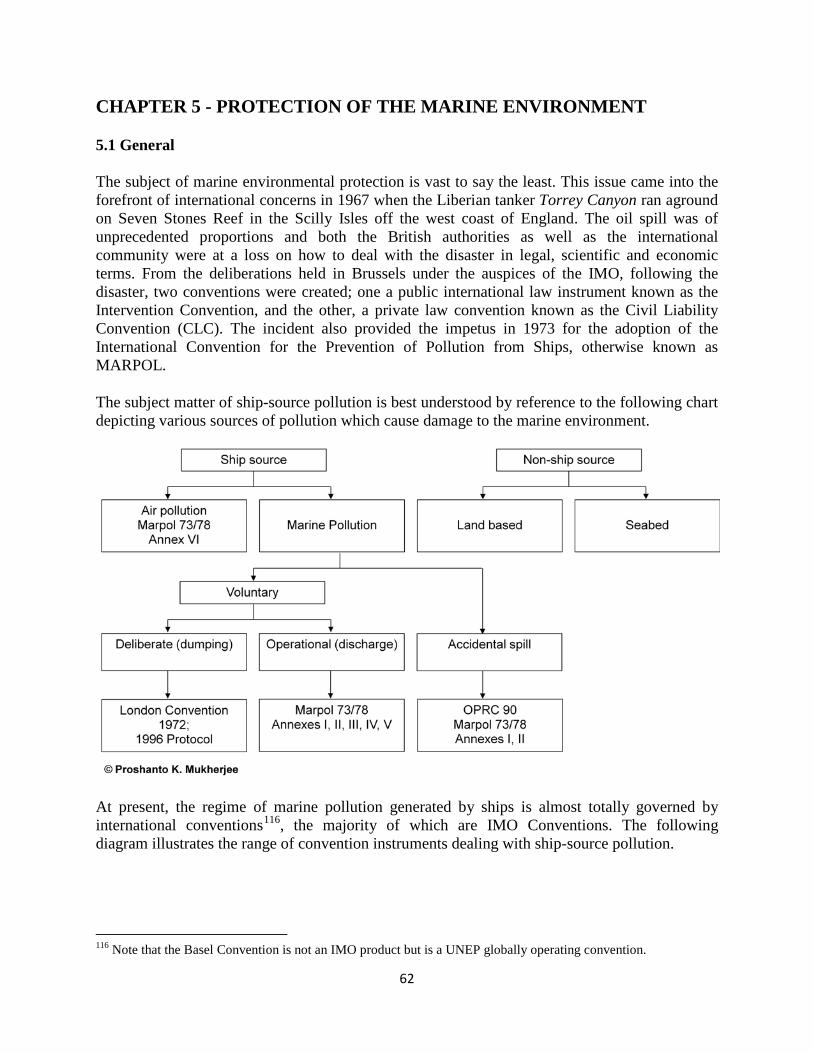
62
CHAPTER 5 - PROTECTION OF THE MARINE ENVIRONMENT
5.1 General
The subject of marine environmental protection is vast to say the least. This issue came into the forefront of international concerns in 1967 when the Liberian tanker Torrey Canyon ran aground on Seven Stones Reef in the Scilly Isles off the west coast of England. The oil spill was of unprecedented proportions and both the British authorities as well as the international community were at a loss on how to deal with the disaster in legal, scientific and economic terms. From the deliberations held in Brussels under the auspices of the IMO, following the disaster, two conventions were created; one a public international law instrument known as the Intervention Convention, and the other, a private law convention known as the Civil Liability Convention (CLC). The incident also provided the impetus in 1973 for the adoption of the International Convention for the Prevention of Pollution from Ships, otherwise known as MARPOL.
The subject matter of ship-source pollution is best understood by reference to the following chart depicting various sources of pollution which cause damage to the marine environment.
At present, the regime of marine pollution generated by ships is almost totally governed by international conventions116
, the majority of which are IMO Conventions. The following diagram illustrates the range of convention instruments dealing with ship-source pollution.
116 Note that the Basel Convention is not an IMO product but is a UNEP globally operating convention.
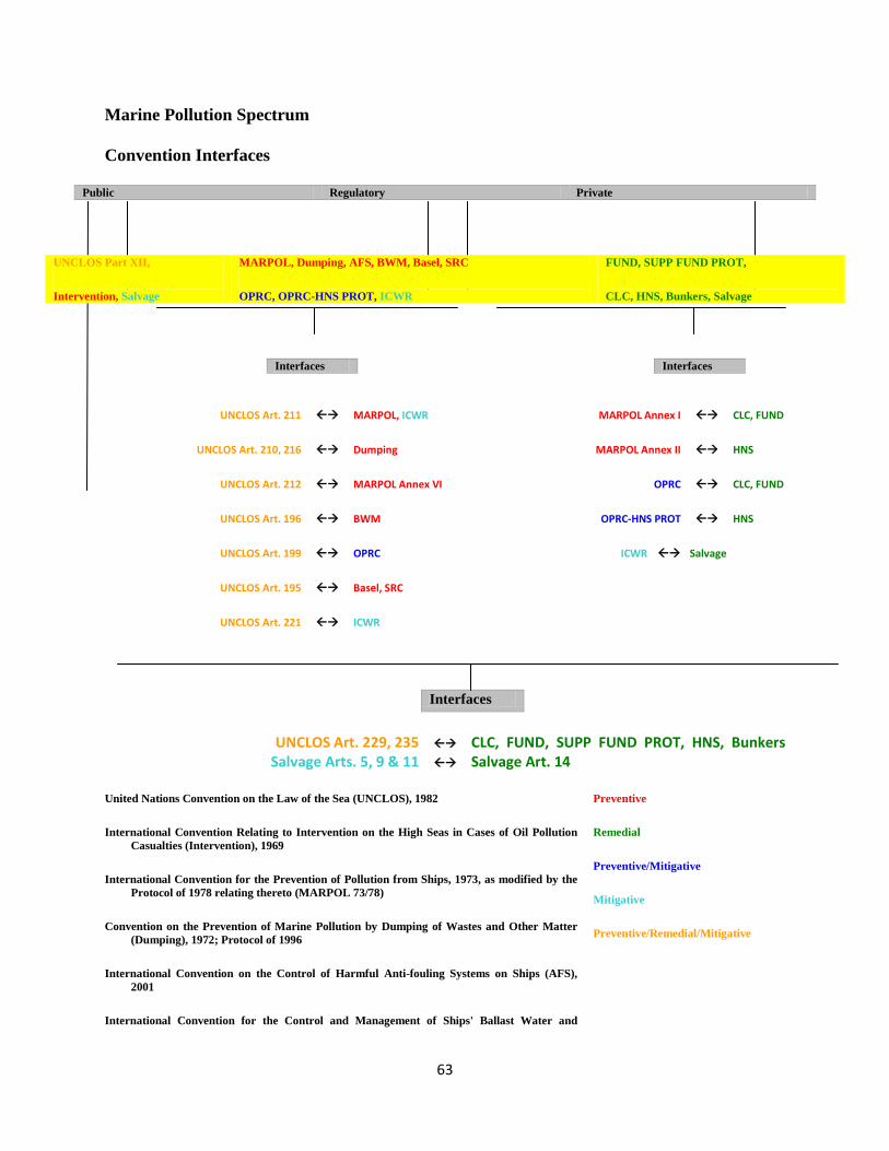
63
Marine Pollution Spectrum
Convention Interfaces
Public Regulatory Private
UNCLOS Part XII,
Intervention, Salvage
MARPOL, Dumping, AFS, BWM, Basel, SRC
OPRC, OPRC-HNS PROT, ICWR
FUND, SUPP FUND PROT,
CLC, HNS, Bunkers, Salvage
UNCLOS Art. 211 MARPOL, ICWR MARPOL Annex I CLC, FUND
UNCLOS Art. 210, 216 Dumping MARPOL Annex II HNS
UNCLOS Art. 212 MARPOL Annex VI OPRC CLC, FUND
UNCLOS Art. 196 BWM OPRC-HNS PROT HNS
UNCLOS Art. 199 OPRC ICWR Salvage
UNCLOS Art. 195 Basel, SRC
UNCLOS Art. 221 ICWR
Interfaces
UNCLOS Art. 229, 235 CLC, FUND, SUPP FUND PROT, HNS, Bunkers Salvage Arts. 5, 9 & 11 Salvage Art. 14
United Nations Convention on the Law of the Sea (UNCLOS), 1982
International Convention Relating to Intervention on the High Seas in Cases of Oil Pollution Casualties (Intervention), 1969
International Convention for the Prevention of Pollution from Ships, 1973, as modified by the Protocol of 1978 relating thereto (MARPOL 73/78)
Convention on the Prevention of Marine Pollution by Dumping of Wastes and Other Matter (Dumping), 1972; Protocol of 1996
International Convention on the Control of Harmful Anti-fouling Systems on Ships (AFS), 2001
International Convention for the Control and Management of Ships' Ballast Water and
Preventive
Remedial
Preventive/Mitigative
Mitigative
Preventive/Remedial/Mitigative
Interfaces Interfaces
64
Sediments (BWM), 2004
Basel Convention on the Control of Transboundary Movements of Hazardous Wastes and Their Disposal (Basel), 1989
International Convention on Oil Pollution Preparedness, Response and Co-operation (OPRC), 1990; HNS Protocol (OPRC-HNS Protocol), 2000
International Convention on Civil Liability for Oil Pollution Damage (CLC), 1992
International Convention on the Establishment of an International Fund for Compensation for Oil Pollution Damage (FUND), 1992; Supplementary Fund Protocol (SUPP FUND PROT), 2003
International Convention on Liability and Compensation for Damage in Connection with the Carriage of Hazardous and Noxious Substances by Sea (HNS), 1996
International Convention on Civil Liability for Bunker Oil Pollution Damage (Bunkers), 2001
International Convention on Salvage (Salvage), 1989
Nairobi International Convention on the Removal of Wrecks, (ICRW) 2007
The Hong Kong International Convention for the Safe and Environmentally Sound Recycling of Ships (SRC), 2009
© Proshanto K. Mukherjee
5.2 MARPOL 73/78 Convention
After its adoption in 1973, MARPOL was subsequently modified through a Protocol of 1978 and is now generally referred to as MARPOL 73/78. The Convention consists of six annexes providing regulatory regimes for six different types of pollutants, the first of which is oil. Incidentally, this Annex was designed to subsume the earlier 1954 Convention generally known as “OILPOL” which was the only convention on ship-source marine pollution up to that point in time.
Without delving into too much detail which may be simply incidental to the present discussion, the salient features of MARPOL are set out below in summary form.
5.2.1 General characteristics and layout
• The characteristics of MARPOL can be described as Regulatory, operational, preventive and technical
• MARPOL consists of the Final Act, Articles of 73 Convention and 78 Protocol, Protocol I, Protocol II, Annexes I to VI, Appendices to Annexes, Unified Interpretations
Salient Features of Articles & Features Common to Most Annexes
65
• Tacit Amendment Procedure • Special Areas • Reception Facilities • Surveys & Certification • Record Books & Plans • Port State Control • Exceptions
Specific Features of Each Annex
• Annex I: Operational Discharge Standards; ODMACS equipment, clean ballast, preventive measures relating to spills;
• Annex II: Categories of NLS (A, B, C & D); Other Liquid Substances, o Operational Discharge Standards, Procedures and Arrangements;
• Annex Ill: Packing, Marking Labelling, Documentation and Storage o Prescriptions, IMDG Code;
• Annex IV: Operational Discharge standards, holding tanks, size and complement criteria;
• Annex V: Prohibition on plastics and synthetic materials, comminuted and ground wastes, dunnage, packing and lining material;
• Annex VI: Protocol of 1997, Sox, Emission Control Area — Baltic Sea, Nox Emissions from Diesel Engines, Prohibition on ozone depleting substances
MARPOL is also primarily a flag state convention like SOLAS and STCW but as a regulatory convention it is also closely related to the ship-source pollution aspects of Part XII of UNCLOS. In particular, it can be said that MARPOL flows from Article 211 of UNCLOS; however Article 212 which bears the caption “pollution from or through the atmosphere” can be considered to represent the blueprint for Annex VI of MARPOL. Also, Articles 210 and 216 of UNCLOS deal with pollution by dumping and this is an activity which can also be described as ship-source pollution. Notably, however, the expansion of the dumping regime in terms of regulatory law is not to be found in MARPOL but rather in the so-called London Dumping Convention 1972 modified by its Protocol of 1996117
. Prevention of ship-source pollution whether it results from operations on board or is a deliberate act such as in dumping, can take place on the high seas or in coastal waters. There are therefore regimes under both these conventions as well as a host of regional conventions that deal with the subject of ship-source pollution.
117 Convention on the Prevention of Marine Pollution by Dumping of Wastes and Other Matters.
66
CHAPTER 6 - SPECIFIC LEGAL ISSUES
6.1 Routing systems, sea lanes and traffic separation schemes
The starting point of this discussion must be by reference to routing systems and traffic separation schemes in UNCLOS. Article 211 under Part XII mentions routing systems to be put into place to minimize the threat of accidents likely to cause pollution. In Article 22 there is mention of sea lanes and traffic separation schemes which can be instituted in the territorial seas for navigational safety and the regulation of passage of ships. Sea lanes and traffic separation schemes (TSS) must be clearly indicated in nautical charts by the coastal state through which due publicity must be given. Sea lanes and traffic separation schemes are also mentioned in Article 41 which deals with transit passage through international straits. Under this Article states bordering straits can designate sea lanes and prescribe TSS which must be referred to IMO at the proposal stage before they can be adopted. Both sea lanes and TSS may be instituted by an archipelagic state for the continuous and expeditious passage of ships.
Routing systems are also dealt with in Chapter V of SOLAS in Regulation 10 which has been discussed earlier in this Report. It must be reinforced that such systems can only be made mandatory when adopted and implemented in accordance with IMO Guidelines and Criteria which is recognized as the only international body with competence in this matter.
The issue of TSS is also addressed in Rule 10 of COLREGS. The Rule applies to TSS adopted by IMO and provides for specific measures that a vessel using a TSS must adhere to in terms of practical navigation and in particular, keeping to the appropriate traffic lanes. These specific rules, of course, envisage a TSS that is fixed until it is changed by the coastal state concerned and adopted by the IMO. The design of the TSS must take into account the nature and density of traffic and also oceanographic factors. Vessels crossing a TSS should do so at a wide angle and those entering the appropriate lane of a TSS should do so at a narrow angle. Vessels not using a TSS must avoid it by a wide margin. These specific rules can attract penal sanctions if they are violated.
6.2 Vessel Traffic Systems (VTS) and Vessel Traffic Management Systems (VTMS)
Closely associated with routing systems and traffic separation schemes is the concept of vessel traffic systems (VTS). In SOLAS this is referred to in Regulation 12 of Chapter V under the caption “Vessel Traffic Services”. This is an expression that is often used interchangeably with vessel traffic systems. The SOLAS terminology obviously views VTS as a service provided by a coastal state to shipping. The use of the word “system” in this context encapsulates not just services but also regulation of traffic; in other words, requirements that ships need to observe in the interests of safety and efficiency of navigation and protection of the marine environment. As discussed earlier, VTS refers to services provided by State Parties to SOLAS but in the view of this author VTS as in “vessel traffic systems” has a wider connotation which goes beyond simply the provision of services. Furthermore, VTS in the SOLAS context also calls for Flag State co-operation through oversight of their ships in complying with VTS requirements.

67
It is notable that the IMO has adopted Guidelines for the planning and implementation of VTS118
The concept of the VTMS is arguably wider than the concept of VTS although there are those who would consider both as usable interchangeably without any substantial distinction between the two. In the view of this author the word “management” in the expression VTMS provides for a broader ambit which includes provisions of services and regulatory requirements extending to the notion of traffic management employing advanced technology operated by shore-based regulators and administrators. Whether or not such distinction is justifiable in practice is a moot point. What is germane to the issue is how much navigational control of a ship should, as a matter of legal and practical principle, be transferred to shore-based “navigators” from the hands of the ship’s master or the pilot acting as the local navigation adviser to him. In posing this question one arrives at a dichotomy in that the pilotage services are in some instances a part of VTS or VTMS where it exists although in many others the VTS/VTMS and pilotage services are separate and co-exist independently. Another noteworthy point is that VTS or VTMS may be a part of port administration and operation or it may not. Where it is not, the system (or services) would be one that extends beyond the physical and legal perimeter of port premises and becomes subject to administrative authority of the Coastal State which is usually the maritime administration of the Government. Allied with the VTS and VTMS concepts is the subject matter of aids to navigation in fairways and navigation channels or even along the coast as a part of a TSS or otherwise a buoyage system.
by State Parties to the Convention. Also, paragraph 5 of Regulation 12 expressly states that neither Regulation 12, nor the IMO Guidelines are to prejudice the rights and duties of Coastal States under international law or the legal regime of international starts and archipelagic sea lanes as entrenched in UNCLOS.
The reach of a typical VTMS is a matter for legal consideration in some instances because of situations where a shore-based authority of the Coastal State purports to regulate the navigation of foreign ships beyond the seaward extremities of the territorial sea. In these instances the question arises as to whether the Coastal State has any jurisdiction at all or whether the system can only work through voluntary compliance by foreign ships. The Eastern Canada Traffic Regulations operating in a vast sea area including the entrance to the Saint Lawrence Sea Ways is a good example. The Regulations require ships to report the shore-based authority twenty four hours in advance of entering the VTMS zone. This would be tantamount to regulating a ship whose speed is fifteen knots at a distance of some 350 nautical miles which falls on the high seas. The Canadian Authorities recognize that requiring any mandatory compliance would be contrary to international law and therefore, rely only on voluntary compliance.
6.3 Flag State, Port State and Coastal State
The Flag State in relation to a ship is the State whose nationality is held by it. The Port State in relation to a ship is the State in whose port or offshore terminal a ship has entered voluntarily. The Coastal State is that State in relation to a ship in whose maritime zone a ship is situated at a given time. Of course, the same state may at one point in time be the Flag State of a ship where the ship holds its nationality, but may be a port or coastal state in relation to a foreign ship. Thus, in relation to a ship the concept of a port state or a coastal state does not apply if that state is also 118 Resolution A.857(20).

68
the flag state of the ship. The rationality is that the flag state has jurisdiction over a ship that holds its nationality regardless of its location, and therefore, does not need to apply port state or coastal state jurisdiction over it.
It is notable that flag state jurisdiction over a ship is predominant and is without hindrance except in those instances where another state exercises port or coastal state jurisdiction under international law. Similarly, on the high seas the flag state jurisdiction over its ships is virtually exclusive except where the Intervention Convention applies or the laws under UNCLOS relating to piracy apply which provides for universality of jurisdiction, and in cases of hot pursuit under UNCLOS where also the coastal state jurisdiction applies within certain limitations. Thus, it is a point of observation that IMO regulatory conventions are basically flag state conventions even though in respect of SOLAS, MARPOL and STCW there is a provision for application of port state jurisdiction. By contrast, there are virtually no IMO Conventions, except perhaps the SAR Convention which involves the application of coastal state jurisdiction. UNCLOS, as the constitution of the oceans, has ample provisions covering all these three types of jurisdictions. Since flag state jurisdiction is predominant on the high seas, including in cases of collisions involving both civil and criminal jurisdictions, any attempt by any other state purporting to exercise jurisdiction over a ship on the high seas is likely to face insurmountable obstacles under the international maritime law as it currently prevails. In today’s milieu of highly advanced technological devices, the reach of navigational control from shore-based stations is practically feasible but there are legal impediments.
When it comes to the role of port states under international law, there are two elements that need to be considered and clearly understood. The first is the notion of port state jurisdiction which, following the definition of a port state indicated above signifies the power and authority of a port state over a foreign ship when the ship is voluntarily in a port or offshore terminal. The second element is port state control (PSC) which is the mechanism or device through which port state jurisdiction can be asserted and exercised. PSC is an integral part of SOLAS, MARPOL and STCW and also certain ILO Conventions, the chief one being ILO 147 on Minimum Standards. Once MLC enters into force that Convention will be added to the list.
PSC was conceived as a complement, not a substitute, to effective enforcement of maritime safety and marine environmental protection standards by flag state administrations. It is to be noted in this context that whereas the recognized organizations perform a delegated flag state function vis-à-vis the ship, PSC is a port state prerogative under international law designed to protect port and coastal state interests from the detrimental effects of substandard foreign ships entering the ports or offshore terminals of such states. PSC was originally conceived as an interim measure; however, all indications are that the regime is here to stay. Explicit provisions in a number of specific conventions as mentioned above have institutionalized the PSC regime.
Under the PSC regime, “control” is, in the first instance, limited to inspection of the various certificates which a ship is required to carry under the relevant maritime conventions. Only if there are “clear grounds” for the inspector to believe that the condition of the ship is inconsistent with the relevant certificate, can he then carry out a physical inspection of the ship and its equipment. However, relatively recent amendments to SOLAS, MARPOL and STCW now afford certain extended powers to PSC inspectors.
69
Under a PSC regime the relevant port state authority is entitled to carry out inspections to verify compliance with both the requirements of international conventions as well as domestic law. Notably, the domestic law may well be different in a particular context from the international law in question; however, if the port state is not a party to such Convention, it has a right to apply its own domestic law since virtually in all cases a ship would be physically situated within the territory or internal waters of the coastal state where full sovereignty applies. Under Article 218 of UNCLOS the port state may exercise port state jurisdiction over a ship for any discharge committed outside the maritime zones in violation of applicable international law but only if that vessel has voluntarily entered the port or offshore terminal. The issue of voluntary entry is often not fully appreciated by PSC authorities. Also, arguably port state jurisdiction would only apply to a ship for a discharge violation committed beyond the maritime zones of the coastal state only if the port state in question is a party to the Convention (MARPOL) which was violated by the ship.
Harmonisation in PSC inspection procedures is achieved through the mechanism of regional Memoranda of Understanding (MOU), the first of which was the Paris MOU established in 1982. Following in its footsteps, a number of other regional MOU’s were established. IMO has encouraged the establishment of these regional instruments in the interest of harmonisation and concerted efforts in the implementation of the PSC regime globally. This is borne out by the promulgation of the two IMO Resolutions mentioned above. At present there are nine such arrangements covering virtually all the seas of the world. They are-
• Paris MoU – Europe and the North Atlantic • Tokyo MoU – Asia and the Pacific • Acuerdo de Viña del Mar – Latin America • Caribbean MoU – Caribbean Sea region • Abuja MoU – West and Central Africa • Black Sea MoU – Black Sea region • Mediterranean MoU – Mediterranean Sea region • Indian Ocean MoU – Indian Ocean region • Gulf Cooperation Council (GCC) MoU – Arab States of the Gulf
The concept of the coastal state is primarily in relation to maritime zones and therefore, features prominently in UNCLOS. As mentioned above, the IMO Conventions, with few exceptions, do not refer to the coastal state or coastal state jurisdiction. The overlap between a state wearing the coastal state hat and the port state hat is one that needs to be carefully noted. In relation to a ship the state may be in the role of a coastal state when the ship is in a maritime zone but when the ship is in a port or offshore terminal the state in question is in the role of a coastal state in addition to being a port state. In other words, the port state concept is subsumed within the role of the coastal state, so that all coastal state rights and jurisdictions remain even when the state is active in the role of a port state; the two are not mutually exclusive. One point to remember is that the same authority exercising port state jurisdiction may also exercise coastal state jurisdiction from the same physical coastal station within the premises of a port or offshore terminal, or may operate from a point outside such premises. In the latter case, the coastal state jurisdiction will not normally reach beyond the maritime zones appurtenant to it into the high seas except in the few instances explained above.
70
6.4 Hydrographic Implications
Hydrography as a discipline can be said to fall under the general rubric of marine scientific research (MSR). This is evident from two provisions in UNCLOS. Under Article 19 (2)(j) reference is made to “research or survey activities” in one breath as an item of non-innocent passage. In Article 40, similarly, “marine scientific research and hydrographic survey ships, may not carry out any research or survey activities” during transit passage through international straits without prior approval of the States bordering the relevant strait. These constraints obviously pose an impediment to any conducting of surveys on an on-going basis by a foreign hydrographic ship in the territorial seas of a coastal state or State bordering a strait.
The discipline of hydrography consists of two dimensions; one is primarily the determination of water depth at sea or bathymetry as it is known in scientific jargon, and the other is the physical location or position where that depth is to be found expressed in geographical co-ordinates of latitude and longitude. The functional or practical methodology employed for obtaining hydrographic data is hydrographic surveys, which in turn comprise two parameters, namely, depth sounding and corresponding, co-relative positioning of the depth. The data obtained through such surveys is then processed and reduced to numerical and positional depictions in nautical charts. The charted information is necessary for safety of navigation and protection of the marine environment in terms of prevention of casualties at sea including oil spills. The accuracy and quality of hydrographic data in nautical charts is thus of prime importance to the safe navigation of the ship and in preventing ship-source pollution. Most frequently, nautical charts have a crucial role to play in incidents of groundings, strandings and collisions. It is therefore imperative that charted information on soundings or bathymetry be maintained up-to-date on board ships. Traditionally, in the regime of paper charts, ship-board corrections are made with information derived from such devices as notices to mariners as well as radio messages and warnings issued by shore stations and hydrographic offices.
Over the last couple of decades charts have, to a considerable extent, assumed the electronic form so that hydrographic information is available in on-screen displays. This phenomenon is known as ECDIS which is the acronym for “electronic chart display information system” or simply described as the electronic chart. The major advantage of ECDIS is that information can be displayed in real time which would include all updates for any given instance. Originally, the electronic chart was merely an electronic representation of the paper chart known as “raster” which was a static depiction and was of limited advantage119
It is notable that whereas the subject of maritime safety is covered by a number of international conventions which have been discussed earlier in this Report, there is no convention instrument that governs hydrography per se. The international body that deals with hydrography and cartography which are related disciplines as alluded to above, is the International Hydrographic Organization (IHO) whose Secretariat is the International Hydrographic Bureau (IHB) located in
. However, the technology is now highly developed so that dynamic depiction of hydrographic data has become the norm although under the regulatory rules of SOLAS, it is still compulsory to carry paper charts on board so that in the event of a shipboard power failure or other impediment, the navigator can still fall back on the paper chart.
119 See www.imo.org.
71
Monaco. Although the IHO was created pursuant to the treaty bearing its name, unlike the IMO, it is not a UN body, but is an intergovernmental organization (IGO). Another point of observation is that the IHO is not a regulatory body in the same sense as the IMO (although arguably the IMO is also not a regulatory body either), the IHO is undoubtedly a standard-setting body for hydrography and cartography. Thus, standard-setting is an activity and characteristic that the IHO shares with IMO.
The link between the two bodies is through Chapter V of SOLAS addressing safety of navigation which has been discussed extensively in this Report. It will be recalled that there is within the IMO a Sub-committee on Safety of Navigation. Incidentally, Regulation 19.2.4 of Chapter V of SOLAS provides for ECDIS being accepted as meeting the requirements for carriage on board of nautical charts. In the development of ECDIS and its eventual recognition in SOLAS by IMO, the role of IHO was significant. As mentioned earlier, Regulation 9 of Chapter V deals with hydrographic services which address matters relating to hydrographic surveying, and the issue of nautical charts and publications. Needless to say, in this sphere of activities, there is considerable interaction between the IMO and IHO.
72
CHAPTER 7 - POTENTIAL CONFLICTS BETWEEN MONALISA CONCEPT AND EXTANT INTERNATIONAL LAW
7.1 Concept of Sea Traffic Management (STM): Conflict with International Legal Regimes
Conceptually STM is a laudable proposition. As noted earlier, four activities are identified under the MONALISA Project, the first of which is dynamic and pro-active route planning (DPR)120. Under this activity, STM is the element which faces problems of implementation in the face of certain aspects of international law which have been described in a fair amount of detail earlier in this Report. Indeed, DPR itself is an activity which runs counter to international law as it obtains at present. As pointed out in the texts relating to Article 94 under the discussion on UNCLOS, on the high seas the jurisdiction of the flag state over its vessels is virtually exclusive. The exceptions are few and have been identified and explained quite comprehensively by distinguished scholars121
Granted that DPR represents a new model in route planning based on and facilitated by ECDIS and AIS, the principal problem is that there is no provision in UNCLOS or in any IMO conventions including SOLAS that permits route planning to be carried out in conformity with what is dictated by a body other than the flag state of the vessel. Having said that, it is in fact quite common for ships to subscribe to route planning services provided by commercial entities such as meteorological institutes and the like. Arguably, the procurement of such services is not in conflict with any international or domestic laws since ultimately, it is the master’s decision as to what should be the route to be taken by the ship in the given circumstances. The concept of STCC is simply to offer to the master the best routing for the voyage leaving it to the master to decide based on his professional judgment whether or not he will accept the advice. In effect, the only requirement of the STCC to fulfill STM will be to expect the master to stay on his decided routing in the same way as ATM. The routing decided by the master will have been agreed upon with the STCC. MONALISA will also offer different kinds of surveillance to ships depending on the needs of the ship as communicated by the master.
. The purported objects of the proposed STM concept as a part of DPR under the MONALISA project would not seem to fall under any of these exceptions.
Indeed, even though the flag state has almost full jurisdiction over its vessels on the high seas, decisions regarding route planning rest on the master of the ship. The most sensitive and controversial aspect of DPR from an international perspective is the functioning of STM which in essence is a proposition under which information regarding actual routes of all ships at sea are obtained by a sea traffic co-ordination centre (STCC) for the purpose of co-ordinating maritime traffic over the open seas. Assuming that the STCC is based in a coastal state, its reach in so far as gathering information is concerned, is limited to the territorial seas of that state. Thus, there is the dichotomy of the exclusive right of the flag state to exercise jurisdiction over its own ships on the high seas and the jurisdiction of the coastal state over foreign ships being limited to its territorial seas.
120 See Information Paper, Item 7, produced by the NSHC 30th Conference Ålesund, Norway, dated June 2012. 121 See supra note 7, pp. 208-220.
73
It would appear that in order for STM to operate effectively, some particular hardware would have to be installed on board ships. Without such equipment, even if a foreign ship was within the territorial seas of a coastal state and arguably, subject to its sovereign jurisdiction, the objectives of STM would not be fulfilled. Here, there is a major impediment in terms of what is provided for in UNCLOS. Perhaps the most impervious provision is contained in Article 21 (2) which does not permit the application of coastal state laws to design, construction, manning or equipment of foreign ships other than in conformity with international rules or standards, presumably those generated by IMO. Indeed, the specific rules and standards relating to shipboard equipment for purposes of navigational safety are to be found in Chapter V of SOLAS, which has been explained earlier in a fair amount of relevant detail. If new equipment is envisaged for the effectuation of STM, then it has to be provided for in that Chapter which will require necessary amendments122
At the risk of repetition, it must be noted that Articles 17 and 18 provide respectively for the right of innocent passage of a foreign ship in the territorial sea and the meaning of passage requiring it to be “continuous and expeditious”, exception being made only for instances of force majeure or distress. As mentioned earlier, Article 19 (2) has a list of activities that are not innocent. Nowhere in these articles is there any provision for a coastal state to dictate the navigation of a foreign ship other than where there are designated sea lanes and TSS in the territorial sea. In Article 24 there is express prohibition on a coastal state on hampering innocent passage including imposing requirements which in effect deny or impair such right or discriminate in form or fact against ships purporting to exercise the right of innocent passage. These limitations in the territorial sea combined with the almost exclusive right of a flag state on the high seas makes it difficult if not impossible for STM to be operable without amendments being made to the existing international legal regimes.
.
7.2 The Notion of the Dynamic TSS System
One of the new and innovative propositions under DPR in the MONALISA Project is the transformation of the existing static TSS system to one that is dynamic and subject to continuous alteration based on weather, traffic and other parameters. What this essentially means is that traffic separation schemes will be dictated by STM from an STCC on an on-going basis. Of course it is recognized that all TSS are largely within waters under the jurisdiction of a coastal state. Most of these are within the territorial seas but many extend into the EEZ as well. The existing legal regime has been discussed in Section 6.1 and 6.2 of this Report which reflects requirements under SOLAS as well as UNCLOS in terms of the mandatory force of TSS. As stated in the discussion in Section 6.1 and 6.2, it is a prerogative of a coastal state to make compliance with STCC compulsory for all ships within the territorial sea, but where the TSS extends beyond the territorial sea the scheme must be approved by IMO in order for it to be made mandatory to foreign ships. It is envisaged that in some TSS areas the STCC will dictate the flow of traffic by “dynamically separating conflicting ships”. It is further envisaged that such dynamic TSS regulation will save navigation distances, reduce costs and also exhaust emissions from ships. An example of this is the way in which at present ships operate in the Baltic region 122 Shipboard equipment is also addressed in MARPOL Annexes I and II where the requirements pertain to both maritime safety as well as environmental protection, but there is nothing specific to navigational safety which is the essence of DPR and STM.
74
during the winter season123
The difficulty with the “dynamic TSS system” as part of VTM is that there will be a major conflict with the existing regimes under which TSS systems are cast in concrete in nautical charts whereas under the DPR proposal such systems will be subject to constant change and under the control of an STCC. In order to successfully seek to implement a dynamic TSS system, several changes to the present legal regime under UNCLOS, SOLAS and COLREGS, will need to be effectuated.
. Essentially, ships will not head for the same points in a TSS to enter VTMS. The system will automatically provide ships with updated routing information relating to, for example, changes in situations in congested waters, in ports and harbours, as well as weather conditions. Thus, there will be individual monitoring and assistance from STCC in confined waters through TSS areas and dictate course alteration points.
The whole notion of route planning being updated dynamically with real time data includes intrusion into the static TSS system as it currently prevails; and therefore, the concept of STM and DPR as a part of it is in direct conflict with the existing norms of TSS and VTM systems the objectives of which are safety of shipping and protection of the marine environment. This particular aspect of the STM proposal under the MONALISA Project could be quite a sensitive issue for the international maritime community. There will doubtless be different points of view with different national interests at stake which will involve economic and social implications. All these would need to be given serious considerations in the proposed redesigning of the governing legal regimes.
7.3 Concept of the Smart Card, Conflict with STCW, Labour Law under MLC, National Flag State Regimes, Conflict with Unions (ITF) and PSC Regimes
Under the MONALISA Project the STM system also embraces monitoring and verification of certificates held by ship officers. In relation to this phenomenon a new technology has been devised which includes the issue of “a smart card”. In essence this is a maritime ID card with security codes which will enable certificates of officers of particular ships to be checked against shore-based data through the AIS transmission to verify certificate validity. It is envisaged that the system will ensure that officers with the requisite competence are in charge of navigation on the bridge. It will also prevent fatigue which is a major aspect of the human factor which contributes to maritime accidents. The difficulty with respect to the implementation of the so-called smart card proposition is that it is in conflict with existing regimes of issue, verification and recognition of certificates of competency of navigation officers under the STCW and marginally, the MLC Conventions. Therefore, major amendments will be required to effectuate this Proposal for which the concurrence of all parties to STCW will be required. In the first instance, such concurrence does not seem to be readily forthcoming. Therefore, quite some work must be contemplated at the international level before any further development can be expected.
Article 10 of STCW provides that the qualifications and certification of ships’ officers by a State that is not a flag state of a ship can only be undertaken when a ship is in a port or offshore facility and is subject to the port state jurisdiction of that state. It is true that verification of certificates can be made under the PSC mechanism. When the ship is at sea it is only the flag 123 See MONALISA document under the caption “How it works”.

75
state which can exercise jurisdiction over ship officers’ qualification and certificates for service on board the ship, and the jurisdiction of the state that issued the certificate would have the right to deal with such certificates in terms of their issue, suspension or withdrawal.
If the smart card proposal were to succeed one would also have to consider its impact on seafarers’ unions and other collective bargaining bodies operating nationally as well as internationally. Furthermore, it must be appreciated that officers’ unions are often separate from those that govern the labour rights of ratings.
The qualifications held by the navigator are subject to the laws of the state that has issued the certificate in question and only the authorities of that state are entitled to deal with such certificate including its suspension or withdrawal regardless of the nationality of a holder124
7.4 The Baltic Sea Region and Hydrographic Surveys
. Under the STCW Convention Only the flag state authorities have the right to determine whether the qualifications held by the navigator are adequate for service on board of flag state ship.
As mentioned earlier in the Report, under UNCLOS, hydrographic surveys cannot be conducted by a ship in waters under the jurisdiction of a coastal state which is not the flag state of the hydrographic ship. Under Article 19 paragraph 2(j), such activities are not considered to fall within the right of innocent passage of a foreign ship. Furthermore, hydrographic research may be considered to be a component of marine scientific research which will fall under Part XIII of UNCLOS and therefore subject to the “consent regime of that Part”. Thus, there are potential conflicts with international law in terms of the execution of the hydrographic aspect of the MONALISA Project if carried out in waters beyond those referred to in the Baltic Sea Region as discussed below.
The MONALISA Project refers to quality assurance of the hydrographic data but only with respect to major navigational areas in Swedish and Finnish waters in the Baltic Sea. The object is to improve safety and optimization of ship routes in these waters. Given the EU concept of “green transport corridors” which represents the environmental dimension, this is a part of the EU Strategy for the Baltic Sea Region125
In so far as any hydrographic work on the high seas is concerned, there is no potential for conflict with international law. At any rate, it is highly unlikely that on the high seas, inadequate bathymetric data will be an impediment to safe and environmentally sound navigation for ships heading towards the Baltic Sea Region.
. Quality assurance of hydrographic data is identified as the third project activity under MONALISA, the outcome of which is to provide the basis for optimized route planning which is the objective of Activity 1 (DPR). With regard to Activity 3, so long as it is confined to waters within the national jurisdictions of the identified States in the Baltic Sea, no conflict with international law is foreseen provided that there are relevant bilateral or multilateral arrangements in place. Problems will always arise if hydrographic surveys are conducted in waters outside the realm of any such arrangements.
124 See Article 97 (2) of UNCLOS. 125 Information Paper Item C7.
76
Incidentally, the record shows that the States in the Baltic Sea Region have ratified and implemented all the international conventions dealing with prevention, liability and compensation of ship-source oil pollution. The Bunkers Convention has been ratified by all States in the Region except Sweden, but only Lithuania and Russia have ratified the HNS Convention126
.
126 Proshanto K. Mukherjee and Abhinayan Basu Bal, “The status of international and regional Conventions Ship-source marine pollution in states in the Baltic Region” in Report on Baltic Master II, 2010.
77
CHAPTER 8 - CONCLUSION
8.1 Options for Resolution of Conflicts
From the discussion in this Report it is apparent that there are several areas of conflict between proposals put forward in the MONALISA and existing international maritime law contained in various convention instruments, in particular UNCLOS, SOLAS, COLREGS and STCW. Whether or not these conflicts can be resolved remains an issue which must be addressed. Any proposals to that effect may be somewhat speculative in the first instance; however, in the opinion of this author, these are not insurmountable hurdles. To reconcile the conflicts a rational action plan would need to be adopted which would consist of an examination of the proposals emanating from the MONALISA Project to determine whether they can be integrated into the existing international law. Each element of the MONALISA initiative must be considered in light of the existing corresponding areas of international law to determine whether there is a reasonable degree of compatibility.
On certain issues, conventions often provide for discretion on the part of the state party in terms of applying legislative or enforcement jurisdiction or both in respect of certain convention provisions. As a first step, where appropriate circumstances can be identified, some MONALISA proposals may be put into effect through national or regional legislation. Instances of compatibility would be, for example, the SOLAS provisions relating to LRIT, VDR, ships’ routing, TSS, etc., in which the MONALISA proposals could be subsumed. Where this is not possible, in other words, there is a lack of compatibility, and the MONALISA proposals in question could constitute a crucial improvement to safety of navigation and prevention of pollution, amendments to existing instruments could be proposed. This could be the second alternative. It is recognized, of course, that in some instances attempting to amend existing conventions might be a herculean task bordering on impossibility, or may be outright impossible to achieve. In such instances a third option could be adopted. This would be using the voluntary approach to implementation of MONALISA proposals by ships and shore-based personnel provided there is no impediment to such actions under the domestic law of a ship’s flag state or a relevant coastal state.
8.2 Analogies with National Jurisdictions: Canada’s Maritime Traffic Regulatory Regimes
A leading Canadian maritime law academic Professor Edgar Gold noted as early as in 1982 that there was a void in the regulation of international shipping which led to the tradition of the ship master’s virtual autonomy to navigate in any manner that he saw fit. He also noted that “the most significant difference between ATC [air traffic control] and vessel traffic regulation is simply that the latter cannot operate in the existing regime of so-called freedom of the seas”127
Canada adopted the Eastern Canada Vessel Traffic Services Zone Regulation (ECAREG) in 1978 and also instituted Vessel Traffic Service Zones in the Pacific, Atlantic and Arctic Coasts and a VTMS in the Juan de Fuca Strait by 1979. In 2010 the Arctic regime known as
.
127 Ted L. McDorman, “Canada’s Vessel Traffic Management Regime: An Overview in the Context of International Law” in Aldo Chircop; Norman Letalik; Ted L. McDorman; Susan Rolston (Eds.), The Regulation of International Shipping: International and Comparative Perspectives, Brill, 2012. See footnotes 1, 2 and 3 at p. 509 of the article.

78
NORDREG was made mandatory which raised questions by other states about the international legal validity of the system128. As discussed earlier, a coastal state does have the right under UNCLOS to institute sea lanes and TSSs so long as they do not hamper the innocent passage rights of foreign ships in the territorial sea or transit passage rights in the international straits. Under SOLAS Chapter V Regulation 10, mandatory ship routing can be put into place by a coastal state only where such routing system has been adopted by IMO129. However, under Regulation 10(4) submission of a routing system by a coastal state to the IMO is only expressed as an “advice” which appears to be consistent with UNCLOS allowing unilateral creation of sea lanes and TSSs within internal waters and territorial seas as a condition for entry into internal waters, but beyond those waters IMO approval is necessary130
Under section 126 (1)(a) of the Canada Shipping Act, mandatory reporting and obtaining of clearance is required for vessels to enter, leave or proceed within a designated VTS zone. A violation of this requirement is an offence punishable by a fine or imprisonment or both, as well as detention of the vessel
.
131
The Canadian model simply illustrates how potentially conflicting national law can be put into place but not necessarily enforced on all occasions.
. The author is personally aware that despite the existence of the above-mentioned penal provisions, they were not enforced on ships for failure of a reporting requirement if it placed a vessel on the high seas; voluntary compliance was encouraged. As mentioned earlier, the requirement for a vessel at a speed of 15 knots intending to enter the ECAREG zone to report 24 hours in advance could place the vessel at a distance of 360 nautical miles well in the high seas. There has been international opposition to the implementation of the NORDREGS but Canada’s position is that the Regulations are consistent with its rights under Article 234 of UNCLOS which deals with ice-covered areas.
8.3 The STM rationale
It is notable that many of the provisions in the Regulations of Chapter V of SOLAS provide for discretionary actions on the part of the master in relation to safe navigation of the ship. However, there is a dichotomy between shipboard control of navigation and shore side control mainly through electronic communication between shore and ship. Here is where maritime navigation has traditionally been radically different from air navigation. Land-based control of air navigation (air traffic control) has been the norm for many decades. By contrast, such phenomena as VTS and VTMS are relatively recent in the context of maritime navigation. Whether it is navigation conducted by the ship’s navigators or by pilots in pilotage waters, those who belong to the conservative cadre of navigation professionals are die-hard supporters of shipboard control of navigation and are opposed to any attempt by shore-based personnel (desktop navigators) to control shipboard navigation.
128 Ibid., at p. 510. 129 See Henrik Ringbom, The EU Maritime Safety Policy and International Law, Leiden:Martinus Nijhoff, 2008, cited in ibid, at p.513, in footnote 25. 130 Ibid., in footnote 28. 131 Section 138 (1), (2) and (4).
79
The roots of STM are in aviation where its counterpart in that mode of transportation is ATM. The position taken by the conservatives in the field of maritime navigation can well be countered by pointing to the fact that in aviation, ATM is well entrenched and accepted as a norm both in legal as well as in operational terms. In introducing the Global Navigation Satellite System (GNSS) in aviation, it was noted by the International Civil Aviation Organization (ICAO) that safety as a “paramount principle” is embodied in the Preamble and Article 44 (h) of the Chicago Convention132
States recognize that in the provision and use of GNSS services, the safety of international civil aviation shall be the paramount principle
. In making a specific reference to this, paragraph 1 of the Charter on the Rights and Obligations of States Relating to GNSS Services provides in paragraph 1 as follows:
133
In the ICAO Document referred to above, it was also noted in paragraph 11.1 that –
.
It has been generally agreed that there is no legal obstacle to the implementation of CNS/ATM systems and that there is nothing inherent in CNS/ATM systems that is inconsistent with the Chicago Convention.
It is obvious from the above that ATM systems are fully endorsed by ICAO as virtually indispensible ground support facilities which comprise air traffic control, flight information and alerting services collectively known as air traffic services and “which ensure the safety and efficient operation of air traffic throughout the world”. Thus, “ATM contributes substantially to safety in aviation”134. In this context, attention is drawn to Article 37 of the Chicago Convention which deals with adoption of international standards and procedures and mandates the ICAO to adopt, inter alia, “[C]ommunications systems and air navigation aids, including ground marking” and “[R]ules of the air and air traffic control practices”135
In as much as maritime navigation is admittedly of ancient vintage where traditional methods of navigation have always been held in high esteem, technological advancement has provided compelling reasons for the acceptance and adoption of alternative devices employing electronic navigational techniques. While some would make a distinction between shipboard electronic devices under the control of the navigator and aids to navigation external to the ship, it is also a verity that several navigational positioning systems of the latter variety such as Loran, Omega and Decca are very much in vogue in maritime navigation and there are no legal impediments to their use. In essence, STM is conceptually similar and there is therefore every reason for the international community to accept it in the interests of maritime safety and marine environmental protection.
.
132 Convention on International Civil Aviation, 1944. 133 See Global Air Navigation Plan for CNS/ATM Systems, ICAO Doc. 9750 AN/963, Second edition 2002, Chapter 11 – Legal Issues citing the Charter adopted by the 32nd session of the Assembly as Resolution A32-19. 134 See Annex 11 to the Chicago Convention. 135 Chicago Convention, Article 37 paragraphs (a) and (c).

TEN-T PROJECT NO: 2010-EU-21109-S
DISCLAIMER: THIS INFORMATION REFLECTS THE
AUTHORS WIEW AND THE EUROPEAN COMMISSION IS
NOT LIABLE FOR ANY USE THAT MAY BE MADE OF THE
INFORMATION CONTAINED THEREIN.

www.monalisaproject.eu
FOR MORE INFORMATION, CONTACT: Magnus Sundström, MONALISA Project LeaderSwedish Maritime Administration Unit for Research and Innovation
Phone: +46 10 478 46 81 E-mail: [email protected]