lca 19.1 high wycombe settled river...
TRANSCRIPT
LCA 19.1 HIGH WYCOMBE SETTLED RIVER VALLEY

LCA XX LCA 19.1 HIGH WYCOMBE SETTLED RIVER VALLEY
Land Use Consultants 21
KEY CHARACTERISTICS
• Chalk river valley cutting the dipslope and containing the River Wye between
High Wycombe and Bourne End where it flows into the Thames.
• High Wycombe spreads linearly along the valley floor contained by steep wooded and farmed valley sides with a small number of farmsteads.
• The River Wye is hidden in the wider landscape by settlement and is often culverted, although is prominent at The Rye where the river and valley setting forms a distinctive part of the townscape.
• Interspersed arable and pasture farmland comprising medium sized fields delineated by hedgerows. In the south arable dominates the west facing slopes and pasture the east.
• Large blocks of ancient beech and yew woodland occur on valley slopes in the north. Woodland is sparse in the rest of the area with small blocks interspersed with farmland or along valley tops.
• Isolated areas of chalk grassland on the west facing valley slopes are SSSI and LNR. Some remnant areas of orchard also occur.
• Main roads and railways are integrated by settlement along the valley floor and the M40 crosses the valley on pillars. Winding rural roads climb the valley side often contained by tall hedgerows or woodland.
• The Rye open space, through which the River Wye flows, lies on the southern edge of High Wycombe. Formerly common pasture and the site of a Roman Villa and Pan Mill.
• Historic parkland occurs at Wycombe Abbey which extends up the valley slopes to wooded valley tops.
• Fields are predominantly pre18th century irregular enclosure interspersed with 20th century enclosures. Some remnant orchards occur on west facing valley slopes.
• Views are from either side of the valley to the other, to development climbing up the valley sides in the west and wooded and convex farmed slopes in the east. The valley slopes in the south and east, including woodland, farmland and parkland provide an important setting to High Wycombe which extends along the valley floor.
• The valley is crossed by the Chiltern Way long distance path and a number of local footpaths ascend the valley sides or pass through woodland. Two golf courses occur on the valley sides.
• High Wycombe has a medieval core and grew up around the furniture industry. Its modern extensions have spread along the valley floor contained by valley slopes which retain a rural character.


LCA 19.1 HIGH WYCOMBE SETTLED RIVER VALLEY
22 Land Use Consultants
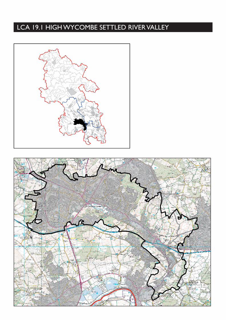
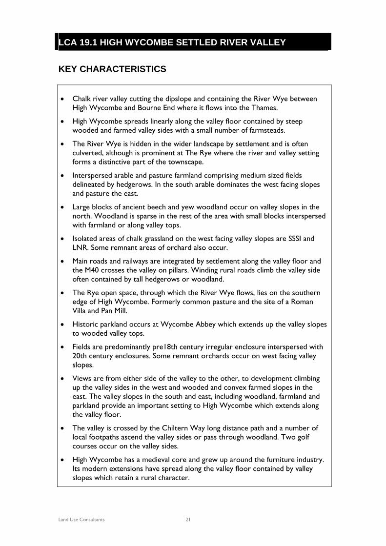
DESCRIPTION Location and Boundaries: The High Wycombe Settled River Valley lies almost entirely within Wycombe District, with two small portions lying in South Bucks District and Chiltern District. It. cuts through the lower chalk dipslope and incorporates the valley of the lower part of the River Wye between High Wycombe and Bourne End (where it meets the River Thames). The valley is separated from the Wye Valley to the north by High Wycombe and is also distinguished from it by its settled valley floor. The boundaries are defined by topography, wooded valley tops and the extent of High Wycombe to the north.
Landscape Character: The High Wycombe Settled River Valley contains the River Wye as it flows through High Wycombe to meet the Thames. The settled valley floor is contained by largely undeveloped valleys slopes with some significant blocks of ancient beech and yew woodland (e.g. Kingswood and Deangarden Wood) and fields of arable and pasture farmland. Some areas of chalk grassland and remnants of orchard occur on the west facing valley slopes. 'The River Wye is hidden in the wider landscape by settlement and is often culverted. It flows through the Rye, an open space on the edge of High Wycombe which adjoins historic parkland at Wycombe Abbey on the valley slopes. The valley is crossed by the M40 and rail and road links are contained within settlement along the valley floor otherwise rural roads enclosed by woodland and tall hedges wind down the valleys sides. The undeveloped wooded and farmland slopes are important in providing a setting to High Wycombe and views across the valley are afforded from the slopes. Despite the dominance of settlement along the valley floor, the valley slopes retain a rural character.
Geology: The valley cuts the chalk dipslope with Middle and Upper Chalk valley sides and a floodplain of Alluvium along the course of the River Wye. Clay with Flints occurs on the valley tops marking the transition to adjacent landscapes. In the south pockets of Ancestral Thames River Terrace Deposits over chalk represent the transition from the chalk dipslope to the River Terrace. Topography/Landform: The town of High Wycombe occupies and extends along the flat valley floor of the River Wye and onto the surrounding slopes in the west. The extent of valley sides is greater in the east, rising to 165m AOD and incised by dry valleys creating a landform with pronounced undulations. The valleys sides in the south and west are more uniform sloping steeply up to 110m AOD. Hydrology: The River Wye and its tributaries are largely contained by settlement and are inconspicuous in the wider landscape. Much of the Wye has been culverted and is hidden through the town. It is visible flowing through The Rye, an open space on the edge of High Wycombe and at Woodburn Park. Land use and Settlement: The valley bottom and valley sides in the west are dominated by built settlement with woodland and open farmland and parkland occurring on the valley sides in the south and east. Large blocks of beech and yew

LCA XX LCA 19.1 HIGH WYCOMBE SETTLED RIVER VALLEY
Land Use Consultants 23
woodland on the north western and south eastern valley sides occur at Kings Wood and Deangarden Wood containing High Wycombe. To the east and south the extent of settlement narrows and is contained along the A40 and valley floor. Here the valleys sides are dominated by pasture and arable farmland with some scattered blocks of broadleaved, mixed and yew woodland. Fields are generally medium sized, bound by hedgerows. Two golf courses and parkland of Wycombe Abbey lie on the valley sides. The town of High Wycombe has a medieval core with the original London to Oxford Road running out from the historic core along the valley bottom. Smaller settlements grew up around river crossing points or mills along the valley and have been enveloped by urban development. High Wycombe now extends to incorporate Loudwater and Wooburn Green towards Bourne End which are modern in character. The wealth of High Wycombe was originally based on corn, cloth making and with furniture making arriving in 1800 using wood from the surrounding beech woodlands. Road and rail routes pass along the valley bottom integrated and contained by settlement while the M40 crosses the Wye Valley more conspicuously on pillars. Access to the valley sides is along intermittent rural lanes enclosed by woodland or tall hedges. The valley is crossed by the Chiltern Way long distance path and a number of local footpaths ascend the valley sides or pass through woodland. Tree Cover: Large blocks of ancient beech and yew woodland occur at Kings Wood, Deangarden Wood and Fernells Wood on the valley slopes above High Wycombe. Elsewhere smaller blocks of broadleaved, mixed and yew woodland occur ‘hanging’ on steep slopes of the eastern incised valley sides, Ancient broadleaved, mixed and yew woodland occurs at Mill Wood on the valleys tops in the south. Small areas of broadleaved, mixed and yew woodland and scrub woodland occur scattered across golf courses. There are some orchard remnants on the west facing valley slopes and trees often occur along field boundaries. In places willow trees depict the course of the river. Perceptual/Experiential Landscape: The valley floor is dominated by settlement but the undeveloped slopes in the south and east retain a rural character with farmland, woodland and parkland. These remaining undeveloped slopes are important in containing the valley and provide a setting to the town of High Wycombe. Main road and rail routes are contained within the valley bottom with the raised M40 crossing the valley more intrusively. The woodland and rolling farmed valley sides provide pockets of tranquillity contrasting with the busy valley bottom. Views are afforded from each side of the Wye valley across to the other, to development climbing up the valley sides in the west and to woodland and convex farmland slopes and parkland in the south and east with High Wycombe relatively contained in the valley bottom. From the south eastern valley slopes views are afforded out towards the Thames Valley and back up the Wye Valley.

LCA XX LCA 19.1 HIGH WYCOMBE SETTLED RIVER VALLEY
Land Use Consultants 24
Biodiversity: Woodland provides significant biodiversity value and many of the woodlands are local wildlife sites. There are a number of chalk grassland sites of ecological importance including a SSSI at Gomm Valley. This site is important for demonstrating natural succession from grassland to woodland and includes a tract of herb-rich chalk grassland. Holtspur Bank is a local nature reserve, an area of dry chalk grassland valley and ancient woodland. BAP priority habitats include broadleaved, mixed, and yew woodland, chalk headwaters, chalk rivers, improved grassland, lowland beech and yew woodland and lowland calcareous grassland. Historic Environment: Predominantly pre 18th century irregular enclosure interspersed with 20th century enclosures. An area of parkland at Wycombe Abbey and orchard remnants on valley slopes. Wycombe Abbey, a Grade II registered park and garden lies on the valley side on the southern edge of High Wycombe. It is a mid-late 18th century landscape park (possibly laid out by Capability Brown) with woodland on the valley tops. It joins The Rye opens space to the north east through which the River Wye flows an ornamental lake known as The Dyke is located. The Rye is also the site of a 2nd century AD Roman Villa and was formerly common pasture grazed by the town’s cattle. The former USAAF Air Base to the south of Wycombe Abbey has cut off an area of parkland, with a mature double avenue of lime trees flanked by large roundels of mature trees, which was originally connected to the house and now lies outside of the character area, within LCA 18.1 Great Marlow Rolling Farmland. Pann Mill watermill, at the eastern end of Wycombe, is the only remaining operating watermill on the River Wye and is a gateway to the Rye open space. There have been mills on the site since at least 1086, and probably earlier. Other archaeological features include Medieval, Bronze Age and Roman finds. Designations: (include those located within High Wycombe itself) • Chilterns AONB
• Registered Parks/Gardens: Wycombe Abbey.
• Scheduled Monuments: Castle Hill; Desborough Castle; Little Market House; St John the Baptist’s Hospital; The Guildhall.
• Archaeological Notification Sites: 35 No.
• Conservation Areas: Wooburn, Wooburn Green, Clapton Mill- Wooburn and Watery Lane - Wooburn.
• Priority BAP Habitats: 7 types.
LCA XX LCA 19.1 HIGH WYCOMBE SETTLED RIVER VALLEY
Land Use Consultants 25
• Biological Notification Sites: 38 No.
• Local Nature Reserve: 1 No.
• Local Geology Site: 2 No.
• Local Wildlife Sites: 18 No.
• SSSI: 1 No. Gomm Valley

LCA 19.1 HIGH WYCOMBE SETTLED RIVER VALLEY
26 Land Use Consultants
EVALUATION
Landscape and Visual Sensitivities Potential landscape and visual sensitivities are as follows: • The remaining undeveloped valley sides in the south and east which form a
setting to High Wycombe which extends along the valley floor.
• The chalk river and its corridor which form part of the urban landscape of High Wycombe.
• Historic parkland at Wycombe Abbey, 18th century irregular enclosures which provide evidence of past land use.
• Remnant areas of orchard, a land use which has largely been lost in this area.
• The Rye open space through which the River Wye flows – an important greenspace on the edge of High Wycombe connecting to Wycombe Abbey and the site of a Roman Villa and Pann Mill.
• Large areas of ancient beech and yew woodland which have biodiversity and recreational value and are associated historically with the furniture making industry in High Wycombe.
• The hedgerow network which connects small areas of woodland and contributes to visual unity.
• Pockets of chalk grassland and associated biodiversity.
• Views from either side of the Wye Valley, across the valley to wooded and convex farmed slopes and parkland in the south and east.
• The rural roads and lanes up valley slopes, which may be under pressure to expand and be widened.
Strength of Character/Intactness: the strength of character and intactness of the High Wycombe Settled River Valley is moderate. Despite the presence of settlement and busy roads along the valley bottom, the undeveloped valley slopes in the east retain a rural character. Strategy/Vision: Conserve the remaining undeveloped slopes which contain High Wycombe in the valley. Conserve the mosaic of parkland, farmland, woodland and chalk grassland which creates a rural character contrasting with the busy, built character of the valley floor.

LCA 19.1 HIGH WYCOMBE SETTLED RIVER VALLEY
27 Land Use Consultants
Landscape Guidelines: • Conserve the remaining undeveloped valley sides in the south and east which
contain and form a setting to the developed valley floor. Restrict incremental development which would alter the character of the valley.
• Conserve and enhance the water quality and flow of the River Wye. Consider opening up the river where possible to create more of a feature.
• Conserve and appropriately manage historic elements and archaeological features, which provide evidence of past use of the land.
• Conserve and enhance orchard areas which have largely been replaced by intensive farming.
• Conserve and appropriately manage The Rye open space and its features which are of recreational, historic and ecological value.
• Conserve and manage woodlands to maintain visual containment and promote biodiversity value.
• Manage and gap up hedgerow boundaries to provide visual unity, connectivity and biodiversity value.
• Conserve and appropriately manage chalk grassland/downland on the dry valley slopes to encourage chalk grassland species. Support and promote expansion and connection of chalk grassland areas.
• Conserve views from each side of the Wye Valley, across the valley to wooded and farmed slopes.
• Maintain the rural character of roads, avoiding road improvements and widening which would alter their character.

A mix of modern and some historic vernacular buildings in the valley bottom with open valley slope backdrop.
Rural farmland valley slopes with settled valley fl oor.
The River Wye fl ows through The Rye open space, one of the few places where it is a prominent feature in this landscape.
Signifi cant blocks of woodland contain High Wycombe on upper valley slopes.
LCA 19.1 HIGH WYCOMBE SETTLED RIVER VALLEY
Convex farmland slopes. Entrance to historic parkland at Wycombe Abbey.