late quaternary co-seismic sedimentation in the sea of
TRANSCRIPT

HAL Id: insu-00178600https://hal-insu.archives-ouvertes.fr/insu-00178600
Submitted on 11 Oct 2007
HAL is a multi-disciplinary open accessarchive for the deposit and dissemination of sci-entific research documents, whether they are pub-lished or not. The documents may come fromteaching and research institutions in France orabroad, or from public or private research centers.
L’archive ouverte pluridisciplinaire HAL, estdestinée au dépôt et à la diffusion de documentsscientifiques de niveau recherche, publiés ou non,émanant des établissements d’enseignement et derecherche français ou étrangers, des laboratoirespublics ou privés.
Late Quaternary co-seismic sedimentation in the Sea ofMarmara’s deep basins
Christian Beck, Bernard Mercier de Lépinay, Jean-Luc Schneider, MichelCremer, Namik Cagatay, Evrard Wendenbaum, Sébastien Boutareaud,
Guillemette Ménot, Sabine Schmidt, Olivier Weber, et al.
To cite this version:Christian Beck, Bernard Mercier de Lépinay, Jean-Luc Schneider, Michel Cremer, Namik Cagatay,et al.. Late Quaternary co-seismic sedimentation in the Sea of Marmara’s deep basins. SedimentaryGeology, Elsevier, 2007, 199, pp.69-85. �10.1016/j.sedgeo.2005.12.031�. �insu-00178600�
1
Title:
Possible Late Quaternary co-seismic sedimentation in the Sea of Marmara’s deep basins
Authors:
Christian Beck1, Bernard Mercier de Lépinay2, Jean-Luc Schneider3, Michel Cremer3, Namik Çağatay4, Evrard Wendenbaum1,2, Sébastien Boutareaud3,1, Guillemette Ménot-Combes5, Sabine Schmidt3, Olivier Weber3, Kadir Eris4, Rolando Armijo6, Bertrand Meyer6, Nicolas Pondard6 and the MARMACORE cruise party: J.-L. Turon3, L. Labeyrie7, E. Cortijo7, Y. Gallet6, N. Gorur8, A. Gervais3, M.-H. Castera3, L. Londeix3, A. de Rességuier3, A. Jaouen9. Adresses: (1) Laboratoire de Géodynamique des Chaînes Alpines, U.M.R. C.N.R.S. 5025, Université de Savoie, 73 376 Le Bourget du Lac, France. E-mail : [email protected] (2) Géosciences Azur, U.M.R. C.N.R.S. 6526, Université de Nice-Sophia-Antipolis, 06 560 Valbonne, France. (3) Département de Géologie et Océanographie, U.M.R. C.N.R.S. 5805, Université de Bordeaux I, 33 405 Talence Cedex, France. (4) Geology & Mining, Technical University of Istanbul. (5) Lamont-Doherty Earth Observatory, Colombia University, New York. (6) Institut de Physique du Globe de Paris, CNRS UMR 7578, Université Pierre et Marie Curie, 75 252 Paris. (7) Laboratoire des Sciences du Climat et de l’Environnement, U.M.R. C.N.R.S.-C.E.A. 1572, 91 198 Gif-sur-Yvette, France. (8) TUBITAK-MAN, PO Box 21, 41 470 Gebze, Kocaeli, Turquey. (9) IPEV, Technopole Brest-Iroise, BP 75, 29 280 Plouzané, France.
CONTENT: Key-words : Abstract: Introduction I - Geodynamic and paleoenvironmental settings II - The Late Pleistocene-Holocene sedimentary fill of the Sea of Marmara: overview of MARMACORE Cruise’s results.
II-1- Technical aspects. II-2 - Sediments composition and layering types. II-3 - Chronology and correlation with data from shelves.
II-3-a-Carbone 14 data. II-3-b- The lacustrine-to-marine transition.
II-4- Occurrence of a major pre-Late Glacial sedimentary “event” - megaturbidite, sismoturbidite - in the Central Basin.
II-4-a- Ocurrence of a pre-Late Glacial Homogenite. II-4-b- Association of the pre-Late Glacial Homogenite with a coarse-sand and mudclasts layer. II-4-c- Depositional model for the pre-Late Glacial Event and smaller-sized similar events.

2
III - Dilatation of the sedimentary pile with increasing depth in the Central Basin III-1- Correlation between Cores MD-2431 and MD-2429. III-2- Strong lateral thickness increase in the marine sedimentary sequence. III-3- Specific imprints of major earthquakes in the marine sedimentary sequence. III-4- Time distribution of sedimentary “events” in Central Basin’s sedimentary record. Conclusions: major earthquake control on time and space distribution of the sediments in
the Sea of Marmara deep basins.
Key-words :
Sea of Marmara, Late Quaternary, cores, high resolution seismic, earthquakes, turbidites,
homogenites.
Abstract:
The deep, northern, part of the Sea of Marmara (northwestern Turkey) is composed of
several aligned, actively subsiding, basins, which are the direct structural and morphological
expression of the North Anatolian Fault’s northern branch. The last 20 kyr of their
sedimentary fill (lacustrine before 12 kyr BP) have been investigated through giant piston
coring onboard R/V MARION-DUFRESNE (MARMACORE Cruise, 2001) and 3.5 kHz
seismic-reflection imagery; the latter was completed by profiles recorded onboard R/V
ATALANTE during MARMARASCARPS Cruise (2002). Especially during the lacustrine
stage, the infilling of the deep basins (Tekirdağ, Central, Kumburgaz, and Çinarcic Basins; up
to 1250 m depth) was dominated by turbidites (with coarse mixed siliciclastic and bioclastic
basal part), intercalated in “hemipelagic-type” fine-grained calcareous and slightly siliceous
clays. Often – especially in the thickest ones – the turbidites show strong segregation and
sharp boundary between coarse part and suspended-load part. In the Central Basin, the 8 m of
a unique sedimentary event include a 5 to 8m-thick “homogenite” well imaged on seismic
profiles. The latter is interpreted as related to a major - here earthquake-triggered - tsunami
effect, as described in Eastern Mediterranean by Kastens and Cita (1981). In the marine
(Holocene) upper part of the sedimentary fill, repeated to-and-fro structures, affecting silt or
fine sand, are evidencing seiche-like effects and, thus, earthquake triggering too. Detailed
correlations between two deep coring sites (1250 and 1200 m) indicate more than 100 %
overthickening in the deepest one; this implies specific processes of distribution of
terrigenous input by dense hyperpycnal currents (high kinetic energy, seiche effect, complex
reflections on steep slopes). The peculiar sedimentary infilling of the Sea of Marmara’s

3
Central Basin (and, by extrapolation, of the whole set) is tentatively interpreted as a direct
consequence of the strong seismic activity; the imprint of the latter is more obvious prior to
the base of the Holocene, as environmental conditions favoured marginal accumulation
(especially on the southern shelf) of large amounts of erosion products available for mass
wasting .
Introduction
Since the results of different investigations conducted on both marine and lacustrine fills,
the direct or indirect sedimentary effects of strong earthquakes have been underlined and
progessively taken in account as paleoseismic indicators (Kuenen, 1958; Sims, 1973, 1975;
Ben Menahem, 1976; Field et al, 1982; Séguret et al, 1984; Seilacher, 1984; Doig, 1985,
1991; El Isa & Mustafa, 1986; Anand & Jain, 1987; Tuttle & Seeber, 1991; Guiraud & Plaziat
1993; Plaziat et al, 1988; Adams, 1990; Piper et al, 1992; Roep & Everts, 1992; Marc &
Agnon, 1995; Moretti & Tropeano, 1996; Beck et al, 1996; Alfaro et al, 1997; Pratt, 1998;
Calvo et al, 1998; Chapron, 1999; Chapron et al, 1996, 1999; Lignier et al, 1998; etc.). These
effects and their sedimentary record appeared particularly obvious in isolated marine basins
and large lakes, submitted to significant seismo-tectonic activity (Hempton & Dewey, 1983;
Siegenthaler et al, 1987; Ringrose, 1989; Van Loon et al, 1995; Syvitski & Schafer, 1996;
Mörner, 1996; Chapron et al, 1999; Shiki et al, 2000; Gorsline et al, 2000; De Batist et al,
2002; Arnaud et al, 2002; Beck, 2005; etc.). During the last decade, these sedimentological
investigations have been developed towards a more paleoseismological approach, through: 1)
analogic modelling (Caselles et al, 1997; Moretti et al, 1999); 2) comparison of geotechnical
and seismological parameters (Obermeier, 1989; Obermeier et al, 1989; Audemard & De
Santis, 1991; Vittori et al, 1991; Rodriguez-Pascua et al, 2002); 3) tentative delimitation of a
“paleo-epicentral” area based on a set of synchronous lacustrine records, and use of different
kinds of archives for the same event (Allen, 1986; Lignier, 2001; Becker et al, 2002, 2004;
Carrillo et al, 2005).
In the Mediterranean realm, a major volcanic and seismic event and its consequences
(tsunami) have been considered as generating huge sedimentary reworking (Kastens & Cita;
1981; Cita et al, 1996; Cita & Rimoldi, 1997). The resulting deposit appears to specifically
fill the deepest parts and to smoothen previous relieves in deep central-eastern Mediterranean
basins; on high resolution seismic reflection profiles, it corresponds to a particular transparent
layer called “homogenite” (Kastens & Cita, 1981) or “unifite” (Stanley, 1981). Based on

4
these previous concepts and other investigation results on large intra-mountainous lakes, the
deepest part of the Sea of Marmara – which underwent a lacustrine episode prior to the last
eustatic rise – was investigated as a possible recorder of the strong and frequent earthquakes
occurring along the North-Anatolian Fault (Mercier de Lépinay et al, 2003; Beck et al, 2003).
I - Geodynamic and paleoenvironmental settings
As evidenced by seismo-tectonic surface studies, seismological investigations, radar
interferometry and GPS geodetic comparisons, the North-Anatolian Fault is considered as a
major active boundary between Aegean-Anatolia and Eurasia plates (Ambraseys, 2002;
Ambraseys & Finkel, 1991; Armijo et al , 1999; 2002; Le Pichon et al, 2001; Rangin et al,
2001; McClusky et al, 2002; etc.)( Fig. 1; a and c: present day kinematics based on GPS
surveys; a and b: general recent tectonic framework indicating extensional, strike slip, and
convergence structures). In northwestern Turkey, the northern branch of this right-lateral
strike slip fault system – with a set of recent high-magnitude earthquakes (Barka, 1996; Stein
et al, 1997; Hubert-Ferrarri et al, 2000; etc.) - is crossing the Sea of Marmara and more
precisely its deep northern part. Previous seismic reflection surveys have underlined the
general geometry of the Cenozoic deep sedimentary fill and its direct relationships with active
faulting (Le Pichon et al, 2001; Ǐmren et al, 2001; Demirbağ et al, 2003; etc.). The present
day tectonic framework is considered as initiated during the Late Miocene (Wong et al, 1995;
Ǐmren et al, 2001); it involves ophiolitic assemblages, metamorphic and igneous rocks
(intrusions and subaerial volcanics), from Paleozoic to Tertiary in age. They represent part of
the Pontides (North) and the Taurides (South) peri-Mediterranean belts. The main relieves
(metamorphic and igneous units), representing potential terrigenous sources, are located on
the southern side of the Sea of Marmara, while the northern border has smaller elevation
(Tertiary sediments and volcanics); this situation is responsible for the terrigenous input on
the southern shelf (Ergin et al, 1991, 1999). The drainage pattern issued from the southern
main relieves converges towards tributaries of the Sea of Marmara, while, north of it, the
main hydrologic system flows westwards, avoiding significant input on the northern shelf.
As connecting the eastern Mediterranean (Aegean Sea) and the Black Sea through two
shallow sills (Dardanels and Bosphorus) the Sea of Marmara underwent the consequences of
the last glacio-eustatic cycle (Ryan et al, 1997; Aksu et al, 1999; Çağatay et al, 2000, 2003;
Major et al, 2002; etc) and recorded the associated 120 m sea-level rise. Recent
paleoenvironmental studies through coring and seismic imagery have been dedicated, by

5
different teams, to the analysis of the Black Sea/Sea of Marmara connexions and especially
the last one considered as a major (catastrophic?) environmental change (Ryan et al, 1997;
etc.). These recent modifications have been investigated through short gravity cores either in
deep basins or in shallow shelves positions (Çağatay et al, 2000, 2003). The lacustrine to
marine change is considered to have occurred around 12 kyr BP Cal., and is represented either
by a sharp limit in shallow marginal sites, and/or by a more progressive change in deep
situations.
Although also concerned by these paleoenvironmental aspects, the here-presented part
of MARMACORE Cruise’s results mainly focuses on the search of impacts of the seismic
activity on recent sedimentary processes.
II - The Late Pleistocene-Holocene sedimentary fill of the Sea of Marmara: overview of
MARMACORE Cruise’s results.
II-1- Technical aspects.
The MARMACORE Cruise took place from the 20th of August and the 13th of
September 2001, as part of the larger GEOSCIENCES MD 123 program. Onboard R/V
MARION-DUFRESNE, a set of 8 long piston cores were retrieved using the CALYPSO
giant piston corer. Five cores were taken in deep situation (1250 to 1100 m), and three in
shallower parts (800 to 400 m); 3.5 kHz profiles were performed for site-surveying and
for longer profiles across the different basins (Fig. 2) during transits. The
MARAMACORE cruise’s seismic grid was later completed by 3.5 kHz profiles acquired
during MARMARASCARPS cruise, in addition to short piston cores (see Armijo et al,
2004); the whole grid is represented on Fig. 2. The eight long cores (21,8 to 37,3 m;
labelled MD01-2424 to MD01-2432) were divided in 1,5 m long sections; non destructive
measurements profiles (magnetic susceptibility, sonic velocity, gamma-ray densimetry)
were performed using I.P.E.V.’s GEOTEK multitools core logger. Core sections were
then split for visual description (layering type, sedimentary and tectonic structures) and
preliminary sampling (smear slides for terrigenous and biogenic contents analysis, plant
debris and wood fragments for 14C dating). Specific attention was paid to coarse
terrigenous layers, microtectonic structures, and possible liquefaction features.
Preliminary shipboard studies were completed onshore by detailed Magnetic
Susceptibility profiles using a BARTINGTON MS2 contact sensor (with 5 mm intervals).
6
Laser microgranulometric measurements were performed using a MALVERN Mastersizer
S equipment. X-ray pictures of split cores (MD01-2429 and MD01-2431) have been
realized with D.G.O.’s SCOPIX system (University of Bordeaux I); X-ray scanner
tomography (in I.F.P. laboratory) have been performed on a selected portion of
microfractured sediments in core MD01-2431.
II-2 – Sediments composition and layering types.
All analyzed sections (230 m cumulated) are basically made of fine-grained
terrigenous material with interlayered, sharply different, sequences that will be detailed
here-after. The upper, marine, parts of the eight cores (see Fig. 3), are almost entirely
made of faintly layered clayey-silty, slightly calcareous, mud. Mean grain size, median,
and mode, range between 4 and 8 µm, while calcite content is rather constant, around 15
% ; within the latter, detrital carbonate grains are generally dominant with respect to bio-
induced or biogenic components. This fine-grained – “background” – sediments are
locally enriched in freshwater Diatoms frustules in the lower part; in the upper part,
dispersed calcareous nannoplancton is present. In core MD01-2425 and MD012427, we
observed a conspicuous millimetric layer consisting of an almost holopelagic
nannoplancton ooze (Fig. 3); we tentatively used this “bloom” as a correlation
chronological marker. The silty terrigenous fraction is siliciclastic, mainly from
volcanogenic origin (fresh plagioclase, amphibole and pyroxene, fresh automorphous
brown mica, opaques minerals); metamorphic and plutonic rocks-derived components are
minor (white micas, amphiboles, deformed quartz, etc.). More frequently in the lower
part, diffuse, or concentrated in association with bioturbation, dark pigmentation is
developed, due to diagenetic sulfides.
Particular individual layers (“events”) or successions of layers are intercalated within
these “background” clayey-silty (marine or lacustrine) sediment:
- ash layers: two major probable pyroclastic fallout events (up to 8 cm thick) have
been found in Cores MD01-2428 and MD01-2430 and tentatively correlated (afl-
1 and afl-2; Fig. 3) between these two sites which show a much lower
sedimentation rate; several discrete (less than 5 mm thick) ash-enriched layers
are present in all cores;
- silty-sandy laminated intervals; they are abundant in median parts (lower half of
the marine interval) of Cores MD01-2424, MD01-2425, MD01-2427 (eastern

7
basins), and more dispersed (several tens of cm “sequences”) in Core MD01-
2432 (western basin). In Cores MD01-2429 and MD01-2431 (Central Basin),
they are spaced thin intervals within the upper marine sequence (detailed
discussion in III-2). They consist of millimetric (to infra-millimetric) parallel
planar bedding, involving subtle changes in grain-size (silt, fine sand) and clastic
components. According to textures and components, we interpret this layering as
related to bed-load transport and settling (and not to fluctuations in planctonic
production and/or in parapelagic suspended load), thus implying seafloor
horizontal distribution. The apparent cyclic layering could represent (seasonal?)
variations in locally developed bottom currents as responses to surface ones (in a
convective-like system), more active close to the two sills and during the
beginning of the marine-connected sedimentation (?). An alternate explanation
could be that they represent distal distribution of flood-induced dense bottom
currents, and thus periods of particularly strong and repeated runoff (?). These
speculative interpretations need further detailed laboratory analysis (mineralogy,
texture, time series, morpho-bathymetrical position, etc.);
- turbiditic (in the broadest sense) sequences; they are common in the deepest
cores (MD01-2424, MD01-2425, MD01-2427, MD01-2429, MD01-2431)
excepted for the Tekirdag Basin. With centimetric to decimetric thicknesses,
they are almost entirely intercalated within the lower (lacustrine) part of the
analyzed successions, the highest (visually estimated) frequency being found in
Central Basin’s Core MD01-2431. They usually display a sharp erosive base,
sometimes with ball-and-pillow structures; the basal coarse sands contain shell
fragments concentrations, and sometimes vegetal debris; mineralogy of the
(dominant) siliclastic fraction is similar to the one observed in finer-grained
strata (see above). Part of these turbidites show a classical progressive fining
upward, while for the thickest ones, an abrupt contact separates the bedload basal
term from the suspended-load upper term, the latter turning into a “homogenite”-
type layer; one of the following paragraphs will focus on these specific
sedimentary “events”, and especially on one 8-to-12 m thick unique gravity-
emplaced layer, including a 5-to-8 m thick homogenite.
II-3 – Chronology and correlation with data from shelves.

8
Shipboard preliminary lithostratigraphical correlations (Mercier de Lépinay, Labeyrie,
Çağatay, et al, 2001) was proposed based on a few conspicuous layers (major tephra and
nannoplankton “blooms”). More detailed observations (biogenic content) allowed decipher
the marine upper part from the lacustrine lower sediments, thus completing the correlation
chart.
II-3-a-Carbone 14 data. A.M.S. C14 analysis were performed on 10 wood fragments
found during shipboard core-splitting (plotted on Fig. 3 logs), in Lamont-Doherty Earth
Observatory (9 samples) and in Zürich Federal Polytechnical Institute (1 sample). The results
were calibrated according to Stuiver et al (1998), and using OxCal software; the values
plotted on Fig. 3 logs correspond to highest confidence intervals. Most of the cores appear to
represent the Holocene and part of the Late Pleistocene; the longest core (MD01-2429, 37,3
m) - retrieved from the deepest sub-basin of the Central Basin - appears to represent the
shortest sampled time interval. At the opposite, cores MD01-2428 and MD01-2430 may
represent the last 40 000 to 50 000 yrs BP, if extrapolating mean sedimentation rates.
II-3-b-The lacustrine-to-marine transition. Our chronological data are in agreement
with the hypothesis of a lacustrine-to-marine transition occurring around 12 kyr BP cal. as
proposed by different authors (Çağatay et al, 2000, 2003; Tolun et al, 2002; etc.). Due to the
importance of the “corridor” situation of the Sea of Marmara, between the Black Sea and the
Aegean, the late Quaternary connexion has been investigated and discussed by different
authors, based on coring results and high resolution seismic reflection data, (Aksu et al, 2002-
a and b; Major et al, 2002; Hiscott & Aksu, 2002; etc.). Our preliminary results are in
agreement with chronological data from shallow sedimentary records (southern shelf and
Izmit Gulf) (Çağatay et al, 2000, 2003); we did not observed any abrupt change, favouring the
“deep sill” rather than the “shallow sill” models of Major et al (2002).
Using detailed layering and sediment textures contrasts in Cores MD01-2429 and
MD01-2431, two synthetic logs were built, with potentially reflecting interfaces, and then
compared with corresponding portions of 3.5 kHz seismic lines (taking in account an
estimation of theoretical vertical resolution) (Fig. 4). In the upper (marine) part, the
“permanent” sedimentation is slightly variable with a high siliclastic (clay-silt) and calcareous
fraction, and is interrupted by only a few coarse turbiditic layers. The last-mentioned are
correlated with a few high amplitude reflectors (see Fig. 4-A, 0-32 m interval of Core MD01-
2429 and corresponding acoustic image; 1640-1685 ms t.w.t.); other reflections have variable
amplitude and variable frequency. At the difference, in the lower (lacustrine) part the
“permanent” sedimentation is finer-grained and with a more constant composition (dominant

9
biogenic and bio-induced material). This sediment is mentioned as “hemipelagic-type” and
often appears as clear thin intervals (few cm to ten cm; close ups of Fig. 5) between numerous
interlayered coarse turbiditic layer; added to the contrast with a more constant background
sediment, they are producing reflections with rather constant amplitude and high frequency
(see Fig. 4-A, interval below 32 m of Core MD01-2429 and corresponding acoustic image
below 1685 ms t.w.t.). Thus, the separation between the upper marine period of sedimentation
and lower lacustrine (“hemipelagic-type") can also be done on the high resolution seismic
imagery, and, at least for the two studied sites, its is coherent with other previously mentioned
data. On Core MD01-2431 (Fig. 4-B), the characterization of the lower, “hemipelagic-type”,
interval is not so obvious due to the interlayering of the 8 m-thick megaturbidite described in
the next paragraph.
II-4 – Occurrence of a major pre-Late Glacial sedimentary “event” - megaturbidite,
sismoturbidite - in the Central Basin.
The different seismic profiles crossing the Central Basin (Fig. 2) evidenced a
conspicuous acoustically transparent layer (up to 8 ms two-ways-time thick). Although the
analysis of the complete grid did not permit, with respect to the theoretical vertical resolution,
to clearly identify this layer in other sub-basins (Tekirdağ, Kumburgaz, Çinarcic), the
chronostratigraphic precision of different deep cores from the last-mentioned did not rule out
the existence of a more discrete signature (similar to re-depositional events illustrated on Fig.
5) of the same sedimentary “event”. The homogenous layer, named “homogenite” with
reference to the concept of Kastens and Cita (1982), appears to be the third (upper) term of a
unique megaturbidite; the “homogenite” will be described prior to discussing the genesis of
the whole event.
II-4-a- Ocurrence of a pre-Late Glacial Homogenite.
The profiles presented on Fig. 7 (located on Fig. 6) underlined a specific distribution of
the homogenous transparent acoustic layer:
- restriction to the very deepest parts of the Central Basin (below 1190 m depth),
- sharp lateral ending (see line cb 14, Fig. 7),
- increasing thickness with increasing depth (comparison of central and western part of line
cb3, Fig. 7). Although the “homogenite” represents very fine-grained material (lacking

10
vertical changes), the non-draped configuration implies a deep horizontal arrival, similar to
any hyperpycnal depositional process. Based on the whole 3,5 kHz grid of the Central Basin,
the total volume is estimated between 0,6 and 1,4 km3.
Core MD01-2431 completely crossed this homogenous layer; it can be viewed on a
general reconstructed picture of the core (Fig. 8). Within the uppermost 70 cm, three
dispersed wood fragments could be extracted and dated by Accelerator Mass Spectrometry
C14 measurement. Calibrated (with maximum confidence) ages intervals are: 16,6-17,3 kyr
BP twice (samples A1 and A2), 15,5-16,0 kyr BP (sample A3). Considering the wood debris
as reworked, we propose to select the youngest age as the closest to the homogenite
deposition age, if admitting a unique event (see arguments below). About two meters higher
in a layered part of Core MD01-2431, another wood fragment yielded a 14,1-14,8 kyr BP
(sample A4), which is in agreement with the age proposed for the homogenite, and with the
lacustrine-to-marine transition detected above. In the following, we will name this unit the
pre-Late Glacial Homogenite (PLGH ).
II-4-b- Association of the pre-Late Glacial Homogenite with a coarse-sand and
mudclasts layer.
Between the PLGH and the next underlying “background” hemipelagic-type layer, two
thick and coarse layers are intercalated (Fig. 8):
- dark silicilastic (non stratified) coarse sand (1,7 m thickness), with minor
biogenic content (highly fragmented Molluscs shells, from shallow coastal
environment), and dispersed millimetric wood debris;
- mud clasts breccia (1,0 m thickness); centimetric clasts are made of fine-grained
grey to whitish sediment, with locally preserved stratification; they are
embedded within a coarse sand matrix identical to the overlying one. Based on
microscopic observation (terrigenous and biogenic fractions), the mud clasts are
considered as reworked from the lacustrine well stratified underlying sequence.
The Magnetic Susceptibility signature of these two coarse layers (Fig. 9, left graph) reinforces
the particularity of the coarse sand and the similarity between the mud clasts and the
underlying succession. The M.S. also shows a highly constant value for the homogenite; the
upper marine sequence also yielded (between 2 m and 6 m) a rather constant M.S. profile but
with a different (higher) mean value. The homogenite carbonate content is nearly constant,
between 12,9 à 13,1 %.

11
Detailed grain-size vertical evolution profiles was built with regular sampling in
homogenite and coarse sand layers, evidencing highly constant parameters (mean grain size,
mode, median; between 6 and 7 µm) in the homogenite, and less constant ones in the coarse
sand. A part of the results are plotted as a skewness vs. sorting diagram (Fig. 10), evidencing
or confirming:
- fluctuations of depositional dynamics in the bed-load part (their frequency may
be higher than what the sampling interval allowed to detect);
- sharp transition between the coarse sand and the homogenite;
- highly constant distribution along the 5 meters of suspended-load upper part.
The three intervals are considered as parts of a unique re-depositional “event”, totalizing 8
meters thickness in Core MD01-2431, named in the following the pre-Late Glacial Event
(PLGE).
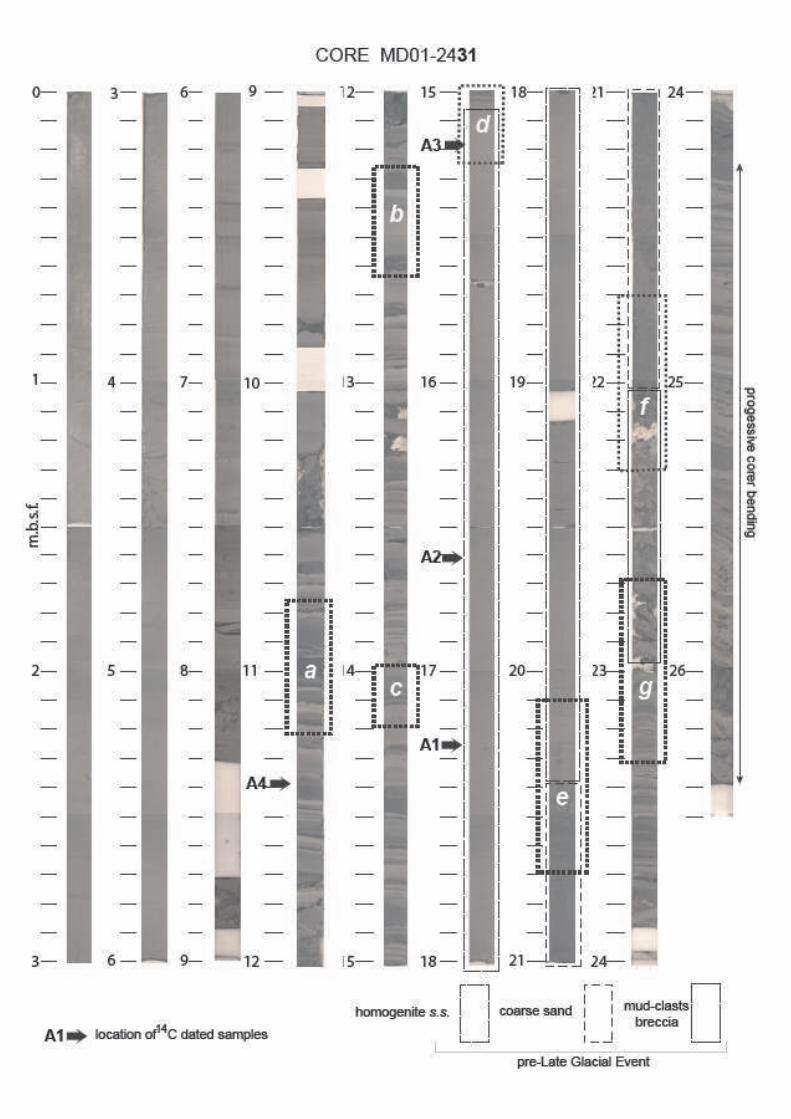
Fig. 11 close ups illustrate different part of the PLGE: the top, with transition from
homogenite to hemipelagic-type sediment (11-d), the limit coarse sand/homogenite (11-e), the
limit mud clasts interval/coarse sand (11-f), the base of the mud clasts interval (11-g).
Excepted for the last-mentioned, the whole set is composed of allochtonous siliclastic
components derived from previously deposited shallower (shelf and shelf margin) sediments.
The Diatoms assemblages determined within the sand, the mud-clasts breccia, and the
homogenite (Boutareaud, 2003) belong to different mixed shelf and delta environments; this
confirms the reworked origin and especially argues against a unique “hemipelagic” source for
the homogenous upper term.
II-4-c- Depositional model for the pre-Late Glacial Event and smaller-sized
similar events.
Generally speaking, the depositional model that can be proposed for the PLGE,
follows the concept of megaturbidite: large size mass wasting turning into dense hyperpycnal
flow (Bowen et al, 1984; Mulder & Cochonat, 1996; Mulder et al, 1994; Bouma, 2000; etc.).
Nevertheless, the sharp limit between the coarse sand and the upper fine-grained unit and the
lack of clear internal structures differ from the usual configuration of classical turbiditic
sequences. This sharp limit is also frequent on smaller-size sedimentary “events” (Fig. 5). The
Mediterranean “Minoan” homogenite (Kastens &Cita, 1982; Cita et al, 1996) is not
associated to a coarse base layer, and this type of unit have been called “unifites” (Stanley,
1981; Stanley & Maldonaldo, 1981). The “hemiturbidite” concept has been proposed by Stow

12
and Wetzel (1990) also for fine-grained homogenous layers, explained by a deep-seated
separation of an upper fine-grained “cloud” from a lower coarser-grained layer, the former
following a much longer trajectory. This separation may also be explained by a “hydraulic
jump” (Fig. 13, case A). This concept explains the horizontal separation, within a unique
mixed particulate flow, of an upper suspended-load flood from a (coarse-grained) basal,
quickly immobilized, layer, because of a bottom relief acting as an obstacle. Initially proposed
for coastal sediments it has been applied to deeper situation as deltaic foresets and turbidites
(Komar, 1971; Nemec, 1990; Kubo & Yokokawa, 2001; Allen, 2001) not necessarily
implying an obstacle. Concerning a turbiditic current, the separation (“jump”) may occur
while crossing the slope (within the canyon), or at the deep plain/slope break (Fig. 13, case
B).
Nevertheless, for the PLGE and for smaller-sized similar sedimentary “events” (Fig.
5), the coarse basal layers are present and supposed to have spread horizontally together with
the upper fine-grained suspension; furthermore, the 3,5 kHz profiles show the same
“acoustic” structure (and thus same constitution) for the PLGE in the whole Central Basin; the
3,5 kHz profiles do not evidence any major relief below the PLGE, which underlying surface
was flat before subsequent faulting. The alternate explanation we propose is a long-lasting
bottom current with several superimposed direction changes, leading into an almost complete
segregation of the bed-load from the suspended-load (Fig. 11). This could be induced by: 1)
either a high velocity turbidity current (high kinetic energy) undergoing several reflections
against the steep slopes of the Central Basin with progressive damping (following the concept
of “contained turbidites” of Pickering & Hiscott, 1985)(Fig. 13, case C); 2) or an oscillatory
movement of the whole water mass, initiated by a sudden bottom modification (co-seismic
displacement, or huge sub-aqueous slump)(Fig. 13, case D). This tsunami effect has been
analyzed and modelled for the Sea of Marmara (Yalçiner et al, 2002); it also can be
considered as a seiche effect as known in large lakes (Siegenthaler et al, 1987; Chapron et al,
1999). The second hypothesis is directly “paleoseismic”, and the first emphasized mechanism
is also often considered as earthquake-triggered (cf. Nakajima & Kanai, 2000). We considered
(see also Chapron et al, 1999; Beck, 2005) that the specific oscillatory mechanism is
responsible for:
- additional extraction of clayey-silty matrix from the initial flux, leading to an increased
volume of upper suspended load, and sharpening the boundary between coarse and fine-
grained layers;

13
- concentration (“ponding”) of the homogenite deposit within deepest hollows. At the
opposite, in a single fine-grained turbiditic flooding on a wide basin floor, the widespread
and thick upper suspended “cloud” may partly lead to upslope deposition with local draped
configuration (Dolan et al, 1989).
As we do not have any direct evidence (on HR seismic images) for corresponding
slump scars, the hypothesis of the gathering of several coeval turbidites (channelized by the
different canyons of the southern edge of Central Basin, Fig. 6) into a unique bottom flux,
cannot be ruled out. Two departure areas could be proposed: the edge of the main large
shallow southern shelf or the deeper irregular inclined shelf mainly bounding the eastern half
of the Sea of Marmara (North of Imrali Island, see on Fig. 2 or Fig. 6). We favour the first
hypothesis because of two different facts: 1) following the present day bathymetry, the
Central Basin is not directly concerned by the drainage crossing the deep eastern shelf; 2)
because of a slighter dipping slope, the latter was well imaged by HR seismic and no slump
scar were detected.
Taking in account the different available data previously mentioned, we favour, for
this huge pre-Late Glacial Event, the combination of a major earthquake (16 000 yrs BP)
occurring during a period of high terrigenous sedimentary supply in relation with specific
Late Glacial climatic conditions. With respect to smaller-sized reworking events (Fig. 5), they
are believed to represent similar mechanisms, with similar triggering, and in a similar
situation with respect to climatic fluctuations. In several cases, these turbiditic layers appear
“sealing” previous disturbances of underlying sediment/water interface (Fig. 11, close up b);
thus three types of impact of major earthquake may be very schematically proposed
(schematized on Fig. 12). The volume differences (or thickness differences) between all these
sedimentary events, must be related to a combination of: i) the characteristics of the triggering
shaking (unique short event vs. repeated shocks); ii) the type of impact on sedimentation
(number of induced mass wasting, size of slope failure, intensity of direct bottom disturbance
(Rodriguez-Pascua et al, 2002)), iii) the distance between investigated depositional basin and
epicentral area.
All these sedimentary “events” have been investigated in the lacustrine lower part of
the Central Basin’s recent fill as they are striking features; does it means that this process
decreased or disappeared in the Holocene? Or did the earthquakes sedimentary recording
became weak or absent? The following paragraph is dealing with the impact of strong seismic
activity during the marine (Holocene) sedimentation.

14
III - Dilatation of the sedimentary pile with increasing depth in the Central Basin
The general Cenozoic configuration of the Sea of Marmara’s sedimentary fill, as
imaged by seismic reflection ( Rangin et al, 20001; Le Pichon et al, 2001 ; Ǐmren et al, 2001),
clearly indicated a complete, long term, tectonic control of the sedimentary fills, especially for
internal configurations in the different sub-basins. With the higher resolution here used, this
relationship may be envisaged, not as a continuous double process (with mean values of
sedimentation rates and fault displacements), but rather as the succession of incremental
events (with instantaneous sedimentation rates and co-seismic faults scarps). Both on 3.5 kHz
profiles and on cores, this second investigation scale allows to explain very local and high
thickness increases as the one evidenced in the Central Basin deepest part (Fig. 7).
III-1- Correlation between Cores MD-2431 and MD-2429.
The synthetic seismic logs (Fig. 4) based on core lithological content, and constructed
for general seismostratigraphy, were then used for detailed correlation across the deep fresh
scarps zone subdividing the Central Basin bottom. The correlation between Cores MD01-
2429 and MD01-2431 (Fig. 14), established with 3,5 kHz image completed by lithogical
comparisons, illustrates this difference. The horizontal distance is less than 10 km and the
bottom depths are respectively about 1250 m and 1200 m. If assuming a constant mean sonic
velocity in the imaged sedimentary pile, the upper marine part (above the “hemipelagite-type”
occurrences) is three times thicker than its lateral time equivalent; the same increased rate
may be measured for the lacustrine part overlying the PLGE. The “homogenite” part of the
last mentioned shows a 75 % thickness increase. If considering the detailed accumulation
processes in the lacustrine part (close ups of Fig. 5), the slow “background” sedimentation
represents 10 to 20 % of the total rate in Core MD01-2431 (higher situation, left log on Fig.
5). If considering Core MD01-2429 (lower situation, right log on Fig. 5) the sedimentary
“events” – representing instantaneous deposits – appear (as the PLGE) strongly dilated, and,
there, the “background” sedimentation represents less than 10 % of the total rate. The
“hemipelagic-type” thickness is almost similar in both cores (indicating absent or negligible
reworking of this material), if considering either separate layers or their total amount. The
strong total thickness increase in the lacustrine part, between the two sides, is thus basically
due to the addition of the thickness differences of each individual gravity “events”. According
to the sedimentological interpretation proposed before (II-4-c ), the difference between both

15
sides of the scarp represents the recording of the successive major earthquakes affecting the
Central Basin and/or its edges. As in the marine upper part such amount of sedimentary
“events” were not observed in Cores MD01-2429 and MD01-2431, it arises the question of
the processes leading to a similar strong thickness difference.
III-2- Strong lateral thickness increase in the marine sedimentary sequence.
As previously mentioned (II-2 ), the upper part of the studied sedimentary pile,
corresponding to marine sedimentation (-12 000 yr to Present), appears poorly layered and
more homogenous, with very few striking coarse turbidites. The last mentioned may not
account for the strong thickness increase measured between sites MD01-2431 and MD01-
2429 (Fig. 14; location on Fig. 6). Then, several questions arise:
- what is(are) the exact depositional process(es) responsible for the general thickness increase
on the deeper side of the main median scarp of the Central Basin ?
- do the silty laminated episodes (Fig. 15 close ups) represent particular high terrigenous
supply? Do they play the same role as the one attributed to the turbidites/homogenites for the
lacustrine sequence (instantaneous huge supply)?
Two sets of data may argue for an explanation: the sediment composition (II-2 ), and
the detailed layering as imaged by X-ray. The latter was performed using SCOPIX device; for
each core section, a continuous X-radiography is done on a 1cm-thick longitudinal sediment
slice (see close ups on Fig. 15).
The grain-size and the mineralogical content of the marine upper sequence indicate a
quite continuous supply of silt (and locally fine sand), either as terrigenous suspended-load or,
more likely, as slow bed-load bottom transport. This sedimentary process must account at
least for part of the increased thickness in deepest situation, in a way similar to contouritic
behaviour (local bottom current acceleration and subsequent higher particulate transport). A
corollary is the question of the relative importance of in situ reworking and additional supply;
the latter is more in agreement with the sedimentation rate and the grain-size.
Another question is the apparent episodic occurrence of these more silty laminated
levels (examples of close ups a, b, and e on Fig.15); they may represent particular climatic
episodes with strong run off and connected hyperpycnal distribution. Nevertheless, these
laminated levels often overly apparently liquefied fine-grained layers (close ups a, b, c, and e,
on Fig. 15); thus, two hypothesis may be proposed: i) these levels have a texture favourable to

16
earthquake disturbances; ii) they represent themselves specific supply induced by major
earthquakes. Several features reinforce the first hypothesis (Fig.15):
- low angle symmetric cross beddings (similar to coastal tidal “flaser” bedding) are
intercalated within the laminated coarser episodes (“fb” on close ups a and g); we interpret
these features as induced by to-and-fro bottom displacements, and, thus, by seiche effects
(earthquake consequence); a “contained turbidite” process cannot be envisaged here;
- intercalated ball-and-pillow structures (close up c), also favoured by textural contrasts
between superimposed layers during shaking (Moretti et al, 1999);
- occurrence of water-escape veins starting from these laminated coarser episode, with
probable associated “boudinage” (close ups d and f).
In brief, during the (Holocene) marine sequence, the sedimentation appears mainly
controlled by episodes of rather cyclic permanent bottom currents with variable suspended-
load or bed-load, depending on velocity and available silty-sandy terrigenous feeding. The
strong lateral thickness variation on both sides of the central scarp develops both in a
continuous way with reinforcement by mean of separated depositional “events”.
III-3- Specific imprints of major earthquakes in the marine sedimentary
sequence.
For the lower (pre-Holocene) lacustrine sequence (II-4-c ), we assumed that the
different gravity reworking events (particularly the homogenites) were triggered by major
earthquakes during a period of high terrigenous accumulation on the edges of the Sea of
Marmara; microfracturation (brittle behaviour of unconsolidated sediment with high water
content) is also believed to represent shaking imprint. If admitting a similar seismo-tectonic
activity during the marine episode, we should search for other types of imprint of major
earthquakes, as the accumulation process is different.
Among the possible earthquake-related features (Fig. 15) we observed:
- subvertical water-escape “vein structures” (close up d); the last mentioned have been
described in soft sediments submitted to frequent tectonic and seismo-tectonic activity, as
accretionnary complexes (Cowan, 1982; Ogawa & Mitata, 1985; Brown & Berhmann, 1990);
- symmetrical flaser bedding-like structures indicating to-and-fro current (close up a) and,
thus, seiche effects;
- boudinage of laminated layers (close ups d and f) that we tentatively interpret as lateral
spread effect; some dewatering veins are connected to theses stretched layers;

17
- horizontal rupturing and displacement of vertical veins (close up a); we consider these
structures as lateral spread shear, thus also related to seismic shocks; such structures have
already been interpreted as earthquake imprints in old sedimentary formations (Föhlisch &
Voigt, 2001);
- liquefaction features (Fig. 15 close up a);
- often an association of these different types.
III-4- Time distribution of sedimentary “events” in Central Basin’s sedimentary
record.
Gathering visual observations and X-ray pictures of Cores MD01-2431 and MD01-
2429, a preliminary rough estimation of time recurrence intervals of sedimentary “events”
considered as earthquake-triggered is proposed. For the lacustrine part, Core MD01-2431 may
be divided into a constant “hemipelagic”-type accumulation with a (slow) mean sedimentation
rate and intercalated turbidites-homogenites (Fig. 5 close ups), as previously done in deep
marine sedimentation by Adams (1990). Between the top of the PLHG and the base of marine
sedimentation (16 kyr to 12 kyr BP), the total mean sedimentation rate is about 1,5 mm/yr,
implying a 0,15 to 0,30 mm/yr rate for the “hemipelagic”-type sedimentation. Considering
this component of the sediment as a planktonic bio-induced and bio-produced settling, then
the same rate can be attributed to the “hemipelagic”-type interval of Core MD01-2429. In
both cores (Fig. 5), these intervals are generally few cm thick; for 2 cm, it should correspond
to 35 to 60 years. About 45 major “events” are visible in Core MD01-2431 for a 6 m
succession lasting about 4 kyr, leading to a mean 80 yrs recurrence time interval.
For the marine part, 6 major events (cf. Fig. 15 close up a) could be correlated between
the two cores; adding other types of disturbances and/or particular layering, 26 events
occurred during the last 12 kyr leading to a 480 yr mean recurrence interval. The difference
observed in apparent “frequencies” between marine and lacustrine sequences could be
explained as follow:
- only major local earthquakes (directly affecting the Central Basin substratum and its edges)
are recorded within the marine part;
- an easier triggering of subaequous slumps related to more available sediments during Late
Glacial (see II-4-c) may explain the higher “frequency” in the lacustrine sequence;
furthermore the arrival of hyperpycnal flows on the Central Basin deep floor represent a
larger provenance area (see submarine canyons pattern on Fig.6);
18
- the estimated “frequency” for the lacustrine sequence is erroneously too high as part of the
normal turbidites may be flood turbidites (Lignier, 2001; Arnaud et al, 2002; Beck, 2005) and
thus related to climatic “events”.
However, the mean estimated time recurrence interval appears of the same order as the
measured recent distribution of major earthquakes along the northern branch of the N.A.F.
(Ambraseys & Finkel, 1991; Barka, 1996; Ambraseys, 2002; Armijo et al, 1999; 2002; Stein
et al, 1997; Hubert-Ferrarri et al, 2000; etc); further more detailed analysis of sedimentary
events in the different basins of the Sea of Marmara (and not only in the Central Basin) should
precise these comparison both for the time and for the horizontal distributions of the
sedimentary “events”.
Conclusions: major earthquake control on time and space distribution of the sediments
in the Sea of Marmara deep basins.
Although mainly based on a more detailed study of the Central Basin, the following
conclusions may be extrapolated to the whole deep part of the Sea of Marmara, as indicated
by similar sedimentary piles in all deep cores and same high resolution seismostratigraphic
succession. The general shape of the recent fill and its internal configuration both evidence a
clear control by seismic activity of the deep sedimentary fill.
Regarding the lower lacustrine sequence (approximately from 20 000 yr B.P. and
12 000 yr B.P.), at least 90 % of the infilling has to be considered as a non linear
(incremental) process; the maximum instantaneous increment being the Pre Late Glacial
Event with 8 to 15 m thickness. This non linear aspect appears directly parallel (synchronous)
to the co-seismic growth of the vertical component of deep fault scarps. Some sedimentary
levels (as PLGE’s top) are reference surfaces for detailed tectonic analysis (Mercier de
Lépinay et al, 2003). Conversely, the vertical component of fault scarps is often guiding the
deep co-seismic sediments arrivals; added to some possible seiche effect, they tend to
smoothen the created bottom relieves.
Concerning the upper marine sequence (12 000 yr B.P. to Present), such non linear
accumulation is not so obvious. The short laminated slightly coarser episodes appear to have
recorded earthquake disturbances but not clearly to represent themselves the impact of
seismic events; even if considering so, their relative cumulated thickness can not account for a
major part of the sedimentation and for the strong lateral thickness increased observed
between the two studied sites in the deep Central Basin. As we did not observed repeated true

19
hemipelagic interval in this upper part, an apparently permanent silty-sandy flux has to be
assumed; an alternative hypothesis is to consider this monotonous, contrast-lacking,
accumulation, as the superposition of fine-grained redeposited interval which limits are not
visible; only a highly detailed analysis of texture and composition of this sequence will allow
to decipher.
Further investigations are in process to improve several proposed conclusions and,
overall, precise the time and lateral distribution of the major “event” in the whole Sea of
Marmara fro the last 20 000 yr. AMS measurements are in process, separately on normal
sedimentation and major “events” to check a specific particle array. Detailed study of Cores
25, 27, and 32, in the other deep basins (Tekirdağ, Kumburgaz, Çinarcic) are in process in
order to attempt event-by-event correlation. The detailed analysis of terrigenous fraction
(through mineralogy) is also necessary to better assume the provenance of reworked material,
in order to model huge hyperpycnal flows trajectories and velocities.
Acknowledgements:
The MARMACORE Cruise is part of GEOSCIENCES Project supported by C.N.R.S.’s
Institut National des Sciences de l’Univers; detailed laboratory investigations have been
funded be the different involved Laboratories associated to the C.N.R.S.. MARMACORE
Scientific Team is grateful to Yvon Balut for successfull management of the giant piston
corer. We acknowledge the captain of R/V MARION-DUFRESNE and the whole crew
(special thanks to Jean Bart’s descendants). We are grateful to J.-M. Daniel, B. Colletta, and
J.-M. Mengus for the realization of X-ray scanner images in I.F.P.’s laboratory.
Références :
Adams J..- (1990) Paleoseismicity of the Cascadian subduction zone: evidence from
turbidites off the Oregon-Washington margin. Tectonics, vol. 9, 4:569-583.
Aksu A.E., Hiscott R.N., Yasar D..- (1999) Oscillating Quaternary water levels of the
Marmara Sea and vigourous outflow into the Aegean Sea from the Marmara Sea-
Black Sea drainage corridor. Marine Geol., 153:275-302.
Aksu A.E., Hiscott R.N., Kaminskie M.A., Mudie P.J., Gillespie H., Abrajano T., Ya�ar D..-
(2002-a) Last glacial-Holocene paleoceanography of the Black Sea and Marmara Sea:
stable isotopic, formaminiferal and cocolith evidence. Marine Geology, 190:119-149.

20
Aksu A.E., Hiscott R.N., Ya�ar D., Isler F.I., Marsh S..- (2002-b) Seismic stratigraphy of Late
Quaternary deposits fro the southwetern Black Sea relief: evidence for non-
catastrophic variations in sea-level during the last 10 000 yr. Marine Geol., 190:61-94.
Alfaro P., Moretti M., & Soria J.M..- (1997) Soft-sediment deformation structures induced by
earthquakes (seismites) in pliocene lacustrine deposits (Guadix-Baza Basin, Central
Betic Cordillera). Eclogae geol. Helv., 90:531-540.
Allen J.R.L..- (1986) Earthquake magnitude-frequency, epicentral distance, an soft
sediment deformation in sedimentary basins. Sedimentary Geol., 46:67-75.
Allen J.R.L..- (2001) Principles of physical sedimentology. The Blackburn Press 277 pp..
Ambraseys N.N..- (2002) The seismic activity of the Marmara sea region over the last 2000
years. Bull. Seism. Soc. Amer., 92:1-18.
Ambraseys N.N., & Finkel C.F..- (1991) Long-term seismicity of Istanbul and the Marmara
Sea region. Terra Nova, 3:527-539.
Anand I. and Jain A. K..- (1987) Earthquakes and deformational structures (seismites) in
Holocene sediments from the Himalayan-Andaman Arc, India. Tectonophysics,
133:105-20.
Armijo R., Meyer B., Hubert A., & Barka A..- (1999) Westward propagation of the North
Anatolian Fault into the northern Aegean: timing and kinematics. Geology, vol. 27,
3:267-270.
Armijo R., Meyer B., Navarro S., King G., Barka A..- (2002) Asymetric slip partitioning in
the Sea of Marmara pull-apart: a clue to propagation processes of the Anatolian Fault.
? Terra Nova, 14:80-86.
Arnaud F., Lignier V., Revel M., Desmet M., Beck C., Pourchet M., Charlet F., Trentesaux
A., & Tribovillard N..- (2002) Flood and earthquake disturbance of 210Pb
geochronology (Lake Anterne, NW Alps). Terra Nova, Vol. 14, 4:225-232.
Audemard F., De Santis F..- (1991) Survey of liquefaction structures induced by recent
moderate earthquakes. Bull. Intern. Assoc. Eng. Geol., 44:5-16.
Barka A..- (1996) Slip distribution along the North-Anatolian fault associated with the largest
earthquakes of the period 1939 to 1967. Bull. Seism. Soc. Amer., 86:1238-1254.
Beck C..- (2005) Lacustrine sedimentary records of Late Quaternary seismic activity in the
northwestern Alps. Case studies and clues for earthquake-origin assessment of
sedimentary disturbances. Submitted for “Paleoseismology” (McAlpin, Audemard,
Michetti, Edts.), Geol. Soc. Amer. Memoir.
Beck C., Manalt F., Chapron E., Van Rensbergen P., & De Batist M.- (1996) Enhanced

21
seismicity in the early post-glacial period: evidence from the post-würm sediments of
Lake Annecy, northwestern Alps. J. Geodynamics, 22, 1/2, p.155-171.
Beck C., Schneider J.-L., Cremer M., Mercier de Lépinay B., Çagatay N., Labeyrie L., Turon
J.-L., Wendenbaum E., Boutareau S., Ménot-Combes G., Hadjas I., Cortijo E., &
MARMACORE Leg Shipboard Scientific Party..- Late Pleistocene major sedimentary
reworking event (homogenite) in the Marmara Sea Central Basin : a combination of
Late Glacial high terrigenous supply with a major earthquake ? Preliminary results of
giant piston-coring and high-resolution seismic reflection. AGU-EGS-EUG joint
meeting, Nice (April 2003).
Becker A., Davenport C.D., Giardini D..- (2002) Palaeoseimological studies on end-
Pleistocene and Holocene around Basle, Switzerland. Geophys. J. Intern.,
149:659-678.
Becker A., Ferry M., Schnellmann M., Giardini D..- (2004) Multiarchive paleoseismic record
of late Pleistocene strong earthquakes in Switzerland. Tectonophysics, in press.
Ben-Menahem A..- (1976) Dating historical earthquakes by mud profiles of lake-bottom
sediments. Nature, 262:200-202.
Bouma A.H..- (2000) Coarse-grained and fine-grained turbidite systems as end members
models: applicability and dangers. Mar. Petrol. Geol., 17 :137-143.
Boutareaud S..- (2003) Etude de l’enregistrement sédimentaire de la sismicité: l’exemple de la
Mer de Marmara. Unpublished Master Memoir, University of Bordeaux I.
Bowen A.J., Normak W.R., & Piper D.J.R..- (1984) Modelling of turbidity currents on Navy
Submarine Fan, California continental Borderland. Sedimentology, 31:169-185.
Brown K. & Berhmann J..- (1990) Genesis and evolution of small-scale structures in the toe
of the Barbados Ridge accretionary wedge. In Moore J.C. and Mascle A., et al, Proc.
O. D. P., Sc. Results, 110:College Station, TX, 229-244.
Çağatay N., Görür N., Algan O., Eastoe C.J., Tchapalyga A., Ongan D., Kuhn T., Kuscu I..-
(2000) Late Glacial-Holocene paleoceanography of the Marmara Sea: timing of
connections with the Mediterranean and the Black Seas. Marine Geol., 167:191-206.
Çağatay N., Görür N., Polonia A., Demirbag E., Sakinç M., Cormier M.-H., Capotondi L.,
McHugh C., Emre Ö., Eris K..- (2003) Sea level changes and depositionnal
environments in the Izmit Gulf, eastern Marmara Sea, during the late Glacial-
Holocene period. Marine Geol., 202:159-173.
Calvo J.P., Rodriguez-Pascua M., Martin-Velasquez S., Jimenez S., De Vicente G..- (1998)
Microdeformation of lacustrine laminite sequences from Late Miocene formations of

22
SE Spain: an interpretation of loop bedding. Sedimentology, 45:279-292.
Carrillo E., Audemard F., Beck C., Cousin M., Jouanne F., Cano V., Castilla R., Melo L., &
Villemin T..- (2005) A Late Pleistocene natural seismograph along the Boconò Fault
(Mérida Andes, Venezuela): the moraine-dammed Los Zerpa paleo-lake.
Tectonophysics, in press.
Caselles J.O., Moretti M., Alfarao, Canas J.A., Clapès J..- (1997) Estructuras sedimentarias de
deformaciòn (sismitas) inducidas por licuefacciòn con un simulador de terremotos.
Geogaceta, Soc. Geol. España, 21 :67-70.
Chapron E..- (1999) Contrôles climatique et sismo-tectonique de la sédimentation lacustre
dans l’Avant-Pays Alpin (Lac du Bourget) durant le Quaternaire récent. Géologie
Alpine, Mémoire H.S. n°30, Univ. J. Fourier, 261 pp..
Chapron E., Beck C., Pourchet M., Deconinck J.-F..- (1999) 1822 AD earthquake-triggered
homogenite in Lake Le Bourget (NW Alps). Terra Nova, 11 :86-92.
Chapron E., Van Rensbergen P., Beck C., De Batist M., & Paillet.(1996)- Lacustrine
sedimentary record of brutal events in Lake Le Bourget (Northwestern Alps-Southern
Jura). Quaternaire, 7, 2/3, p. 155-168.
Cita M.B., Camerlenghi A., Rimoldi B..- (1996) Deep-sea tsunami deposits in the eastern
Mediterranean: new evidence and depositional models. Sedimentary Geology,
104 :155-173.
Cita M.B., Rimoldi B..- (1997) Geological and geophysical evidence for a Holocene tsunami
deposit in the eastern Mediterranean deep-sea record. J. Geodynamics, 1-4 :293-304.
Cowan D.S..- (1982) Origin of “Vein Structure” in slope sediments on the inner slope of the
Middle America Trench off Guatemala. In Aubouin J., von Hene R., et al, Init. Rep.
D.S.D.P., 67:Washington, U.S. Govt. Printing Office), 645-650.
De Batist M., Imbo Y., Vermeesch P., Klerkx J., Giralt S., Delvaux D., Lignier V., Beck C.,
Kalugin I., Abdrakhmatov K.E..- (2002) Bathymetry and sedimentary environments of
Lake Issyk-Kul, Kyrghyz Republic (Central Asia): a large, high-altitude, tectonic lake.
in « Lake Issyk-Kul : its natural environment » (J. Klerkx & B. Imanackunov, Eds.),
NATO Science Series IV, Kluwer Academic Publ., 13 :101-124.
Demirbağ E., Rangin C., Le Pichon X., �engör A.M.C..- (2003) Investigations of the tectonics
of the Main Marmara Fault by means of deep-towed seismic data. Tectonophysics,
361:1-19.
Doig R..- (1985) A method for determining the frequency of large-magnitude earthquakes
using lake sediments. Can. J. Earth Sci., 23:930-937.

23
Doig R..- (1991) Effects of strong seismic shaking in lake sediments, and earthquake
recurrence interval, Temiscaming, Québec. Can. J. Earth Sci., 28 :1349-1352.
Dolan J., Beck C., Ogawa Y..- (1989) Upslope deposition of extremely distal turbidites: an
example from the Tiburon Rise, west-central Atlantic. (1989) Geology, vol. 17, pp.
990-994.
El-Isa Z. H., Mustafa H..- (1986) Earthquake deformations in the Lisan deposits and
seismotectonic implications. Geophys. J. R. astr. Soc., 86:413-424.
Ergin M., Bodur M.N. and Ediger V..- (1991) Distribution of surficial shelf sediments in the
northeastern and southwestern parts of the Sea of Marmara: Straits and canyon
regimes of the Dardanelles and Bosphorus. Marine Geology, Volume 96, pages 313-
340.
Ergin M., Kapur S., Karakas Z., Akca E., Kangal Ö. and Keskin �..- (1999) Grain size and
clay mineralogy of Late Quaternary sediments on a tectonically active shelf, the
southern Sea of Marmara: clues to hydrographic, tectonic and climatic evolution.
Geological Journal, Volume 34, pages 199-210.
Field M. E., Gardner J. V., Jennings A. E., Edwards B. D..- (1982) Earthquake-induced
sediment failure on a 0.25° slope, Klamath River delta, California. Geology, 10:542-
546.
Föhlisch K. & Voigt T..- (2001) Synsedimentary deformation in the Lower Muschelkalk of
the Germanic Basin. In “Particulate Gravity Currents “, W.D. McCaffrey, B.C.
Kneller, & J. Peakall, Edts., Intern. Ass. Sedimentologists Spec. Publ., Blackwell
Science, Vol. 31, p. 279-297.
Gorsline D.S., De Diego T., & Nava-Sanchez E.H..- (2000) Seismically triggered turbidites
in small margin basins : alfonso Basin, Western Gulf of California and Santa Monica
Basin, California Borderland. Sediment. Geol., 135 :21-35.
Guiraud M. & Plaziat J.-C..- (1993) Seismites in the fluvial Bima sandstones: identificatin of
paleoseisms and discussion on their magnitude in a Cretaceous synsedimentary strike-
slip basin (upper Benue, Nigeria). Tectonophysics, 225:493-522.
Hempton M.R., Dewey J.F..- (1983) Earthquake-induced deformational structures in young
lacustrine sediments, East Anatolian Fault, southwest Turkey. Tectonophysics, 98:7-
14.
Hiscott R.N., Aksu A.E..- (2002) Late Quaternary history of the Marmara Sea and Black Sea
from high-resolution seismic and gravity-core studies. Marine Geology, 190:261-282.
Hubert-Ferrarri A., Barka A., Jacques E., Nalbant S.S., Meyer B., Armijo R., Tapponier P.,

24
King G.C.P..- (2000) Seismic hazard in the Marmara Sea region following the 17
August 1999 Izmit earthquake. Nature, 404:269-273.
Ǐmren C., Le Pichon X., Rangin C., Demirbağ E., Ecevitoğlu B., Görur N..- (2001) The north
Anatolian fault within the Sea of Marmara: a new interpretation based on multi-
channel seismic and multi-beam bathymetry data. Earth Planet. Sc. Lett., 186:143-
158.
Kastens K. & Cita M.B..- (1981) Tsunami-induced sediment transport in the abyssal
Mediterrranean Sea. Geol. Soc. Amer.Bull., 92:845-857.
Kuenen P.H..- (1958) Experiments in geology. Trans. Geol. Soc. Glasgow, 23:1-28.
Komar P.D..- (1971) Hydraulic jumps in turbidity currents. Geol. Soc. Amer. Bull., 82:1477-
1488.
Kubo Y. & Yokokawa M..- (2001) Theoretical study on breaking of waves on antidunes. In
“Particulate Gravity Currents “, W.D. McCaffrey, B.C. Kneller, & J. Peakall, Edts.,
Intern. Ass. Sedimentologists Spec. Publ., Blackwell Science, Vol. 31, p. 65-70.
Le Pichon X., Sengor A.M.C., Demirbag E., Rangin C., Imren C., Armijo R., Gorur N., N.
Çagatay, Mercier de Lépinay B., Meyer B., Saatcilar R., Tok B..- (2001) The active
main Marmara Fault. Earth Planet. Sc. Lett., 192 :595-616.
Lignier V..- (2001) Les sédiments lacustres et l’enregistrement de la paléoséismicité.Etude
comparative de différents cas dans le Quaternaire des Alpes Nord-Occidentales et du
Tien-Shan Kyrghize. Unpublished Doct. Thesis, University of Savoy.
Lignier V., Beck C., Chapron E..- (1998) Caractérisation géométique et texturale de
perturbations synsédimentaires attribuées à des séismes, dans une formation
quaternaire glaciolacustre des Alpes (les ”Argiles du Trièves ”). C. R. Acad. Sc. Paris,
327 :645-652.
Major C., Ryan W., Lericolais G., Hadjas I..- (2002) Constraints on Black Sea outflow to the
Sea of Marmara during the last glacial-interglacial transition. Marine Geology,
190:19-34.
McClusky S., Bassalanian S., Barka A., Demir C., Ergintav S., Georgiev I., Gurkan O.,
Hamburger M., Hurst K., Hans-Gert H.-G., Karstens K., Kekelidze G., King R.,
Kotzev V., Lenk O., Mahmoud S., Mishin A., Nadariya M., Ouzounis A., Paradissis
D., Peter Y., Prilepin M., Relinger R., Sanli I., Seeger H., Tealeb A., Toksöz M.N.,
Veis G..- (2002) Global positioning system constraints on plate kinematics and
dynamics in the eastern Mediterranean and Caucasus. Journ. Geophys. Res.,
105:5695-5719.

25
Marco S. & Agnon A.- (1995) Prehistoric earthquake deformations near Masada, Dead Sea
Graben. Geology, vol. 23, 8 :695-698.
Mercier de Lépinay B., L. Labeyrie , N. Çagatay, and MARMACORE Scientific Team.
(2001) IFRTP unpublished shipboard report, 34 p.
Mercier de Lépinay B., L. Labeyrie , N. Çagatay , C. Beck , J.-L. Schneider ,
M. Cremer , J.-L. Turon , L. Londeix , B. Meyer , Y. Gallet , N. Pondard , G. Ménot-
Combes , I. Hadjas , E. Cortijo . Interplay between recent sedimentation and active
tectonics in Marmara Sea. AGU-EGS-EUG joint meeting, Nice (April 2003).
Moretti M., Alfaro P., Caselles O., Canas J.A..- (1999) Modelling seismites with a digital
shaking table. Tectonophysics, 304:369:383.
Moretti M. & Tropeano M..- (1996) Strutture sedimentarie deformative (sismiti) nei depositi
tirreniani di Bari. Mem. Soc. Geol. It., 51:485-500.
Mörner N.-A..- (1996) Liquefaction and varve deformation as evidence of paleoseismic
events and tsunamis. The autumn 10,430 BP case in Sweden. Quaternary Sc. Rev.,
15:939-948.
Mulder T. & Cochonat P..- (1996) Classification of offshore mass movements. J. Sediment.
Res., vol. 66, 1:43-57.
Mulder T., Tisot J.-P., Cochonat P., & Bourillet J.-F..- (1994) Regional assessment of mass
failure events in the Baies des Anges, Mediterranean Sea. Marine Geol., vol. 122, 1/2:
29-45.
Nakajima T. & Kanai Y..- (2000) Sedimentary features of seismoturbidites triggered by the
1983 and older historical earthquakes in the eastern margin of the Japan Sea. Sediment.
Geol., 135:1-19.
Nemec W..- (1990) Aspects of sediment movement on steep delta slopes. In “Particulate
Gravity Currents “, A. Colella & D.B. Prior, Edts., Intern. Ass. Sedimentologists Spec.
Publ., Blackwell Science, Vol. 10, p. 29-73.
Obermeier S..- (1989) The New Madrid earthquakes: an engineering-geologic interpretation
of relict liquefaction features. U.S. Geol. Surv. Profess. Pap., 1336-B, 114 p..
Obermeier S.F., Bleuer N.R., Munson C.A., Munson P.J., Martin W.S., McWilliams K.M.,
Tabaczynski, Odum J.K., Rubin M., & Eggert D.L..- (1991) Evidence of strong
earthquake shaking in the lower Wabash valley from prehistoric liquefaction features.
Science, 251:1061-1063.
Ogawa Y., & Miyata Y..- (1985) Vein structure and its deformation history in the sedimentary
26
rocks off the Middle America Trench off Guatemala. Init. Rep. D.S.D.P.,
84:Washington, U.S. Govt. Printing Office), 811-829.
Pickering K.T. & Hiscott R.N..- (1985) Contained (reflected) turbidity currents in the Middle
Ordovician Cloridorme Formation, Québec, Canada: an alternative to the antidune
hypothesis. Sedimentology, 32:373-394.
Piper D.J.W., Cochonat P., Ollier G., Le Drezen E., Morrison M, Baltzer A..- (1992)
Evolution progressive d’un glissement rotationnel en un courant de turbidité : cas du
séisme de 1929 des Grands Bancs (Terre Neuve). C.R. Acad. Sc. Paris, 314:1057-
1064.
Plaziat J.-C., Purser B.H., Philobbos E..- (1988) Diversity of Neogene seismites of the NW
Red Sea (Egypt): a characteristic sedimentary expression of rifting. Tectonophysics,
153:295.
Pratt B.R..- (1998) Syneresis cracks: subaqueous shrinkage in argillaceous sediments caused
by eathquake-induced dewatering. Sediment. Geol., 117:1-10.
Rangin C., Demirbag E., Imren C., Crusson A., Normand A., Le Drezen E., & Le Bot A..-
(2001) Marine Atlas of the Sea of Marmara (Turkey). IFREMER; ISBN
2-84433-068-1.
Ringrose P.S..- (1989) Paleoseismic (?) liquefaction event in late Quaternary lake sediments
at Glen Roy, Scotland. Terra Nova, 1:57-62.
Rodriguez-Pascua M.A., Calvo J.P., De Vicente G., & Gòmez-Gras D..- (2002) Soft-sediment
deformation structures interpreted as seismites in lacustrine sediments of the Prebetic
Zone, SE Spain, and their potential use as indicators of earthquake magnitudes during
the Late Miocene. Sedimentary Geol., vol. 135, 1-4 :117-135.
Roep T.B. & Everts A.J..- (1992) Pillow-beds: a new type of seismite ? An example from an
Oligocene turbidite fan complex, Alicante, Spain. Sedimentology, 39:711-724.
Ryan W.B.F., Pitman W.C., Major C.O., Shimkus K., Moskalenko V., Jones G.A., Dimitrov
P., Görür N., Sakinç M., Yüce H..- (1997) An abrupt drowning of the Black Sea shelf.
Marine Geol., 138:119-126.
Séguret M., Labaume P., Madariaga R..- (1984) Eocene seismicity in the Pyrénées
from megaturbidites of the South Pyrenean basin (Spain). Marine Geology,
55:117-131.
Seilacher A. - (1984) Sedimentary structures tentatively attributed to seismic events. Marine
Geol., 55:1-12.
Shiki T., Kumon F., Inouchi Y. Kontani Y., Sakamoto T., Tateishi M., Matsubara H.,
27
Fukuyama K..- (2000) Sedimentary features of the seismo-turbidites, Lake Biwa,
Japan. Sediment. Geol., 135:37-50.
Siegenthaler C., Finger W., Kelts K., Wang S..- (1987) Earthquake and seiche
deposits in Lake Lucerne, Switzerland. Eclog. geol. Helv., 80:241-260.
Sims J..- (1973) Earthquake-induced structures in sediments of Van Norman Lake, San
Fernando, California. Science, 182:161-163.
Sims J..- (1975) Determining earthquake recurrence intervals from deformational structures in
young lacustrine sediments. Tectonophysics, 29 :141-152.
Stanley D.J..- (1981) Unifites: structureless muds of gravity-flow origin in Mediterranean
basins. Geo-Mar. Lett., 1:77-83.
Stanley D.J. & Maldonado A..- (1981) Depositional models for fine-grained sediments in the
western Hellenic Trench, Eastern Mediterranean. Sedimentology, 28:273-290.
Stein R.S., Barka A., Dieterich J.H..- (1997) Progressive failure on the North Anatolian Fault
since 1989 by earthquake stress triggering. Geophys. J. Intern., 128:594-604.
Stow D.AV. & Wetzel A..- (1990) Hemiturbidite: a new type of deep-water sediment. Proc.
Ocean Drilling Program, vol. 105B, pp. 25-34.
Stuiver M., Reimer P.J., Bard E., Beck J.W., Burr G.S., Hugen K.A., Kromer B., McCormac
G., Van der Plicht J., Spurk M..- (1998) INTCAL 98 Radiocarbon age calibration,
24 000-0 cal BP. Radiocarbon, 40:1041-1083.
Syvitski J.P.M., Schafer C.T..- (1996) Evidence for an earthquake-triggered basin collapse in
Saguenay Fjord, Canada. Sedimentary Geology, 104:127-153.
Tolun L., Çağatay M.N., Carrigan W.J..- (2002) Organic geochemistry and origin of Late
Glacial-Holocene sapropelic layers and asociated sediments in Marmara Sea. Marine
Geology, 190:47-60.
Tuttle M. & Seeber L..- (1991) Historic and prehistoric earthquake-induced liquefaction in
Newbury, Massachusetts. Geology, 19:594-597.
Van Loon A.J., Brodzikowski K., Zielinski T..- (1995) Shock-induced resuspension deposits
from a pleistocene proglacial lake (Kleszczow graben, central Poland). J. Sedimentary
Res., vol. 65, 2 :417-422.
Vittori E., Labini S., Serva L..- (1991) Paleoseismology : review of the state of the art.
Tectonophysics, 193 :9-32.
Wong H.K., Lüdmann T., Ulug A., & Görür N..- (1995) The Sea of Marmara: a plate
boundary sea in an escape tectonic regime. Tectonophysics, 244:231-250.
Yalçiner A.C., Alpar B., Altinok Y., Özbay Đ., Imamura F..- (2002) Tsunamis in the Sea of

28
Marmara historical documents for the past, models for the future. Marine Geology,
190:445-463.
FIGURES CAPTIONS
Figure 1 – Present day geodynamic settings of the Sea of Marmara. (after Armijo et al, 1999,
2002).
Figure 2 - High resolution seismic reflection grid and coring locations of MARMACORE and
MARMARASCARPS cruises.
Figure 3 - Summary of giant piston coring results in the Marmara Sea (MARMACORE
Cruise), and shipboard proposed lateral correlations.
Figure 4 - Synthetic seismic logs of Cores MD01-2429 (A) and MD01-2431 (B): location of
main potential reflective sedimentary interfaces (left) and correlation with detected
reflectors (right). The marine upper part correspond to variable amplitude and
variable frequency; the lacustrine “hemipelagic-type” lower part correspond to almost
constant amplitude and high frequency.
Figure 5 - Close-ups of split sections of the lower lacustrine part of Cores MD01-2429
and MD01-2431, displaying the frequency of strong contrast interfaces between the
“hemipelagic-type” permanent sediment and coarse redepositional events.
Figure 6- Detailed morpho-bathymetry of the Marmara Sea’s Central Basin, location of giant
piston cores and seismic profiles.
Figure 7- 3,5 kHz profiles across the Central Basin, evidencing a “homogenite”.
Figure 8- General view of splitted Core MD01-2431, showing the pre-Late Glacial
“homogenite” and associated coarse gravity deposits.
Figure 9- Correlations between Cores MD01-2431 and MD01-2429 based on magnetic
susceptibility.
Figure 10- Vertical evolution of grain-size distribution in the pre-Late Glacial “event”.
Figure 11 – Close ups of selected portions of Core MD01-2431. (a: conjugated
microfractures; b: microfracturing with possible sealing by coeval turbidite arrival; c;
possible in situ liquefaction, evidenced by ball-and-pillow – b-a-p – structure; d to g:
details of the pre-Late Glacial event)
29
Figure 12- Schematic genetic model proposed for the pre-Late Glacial Event and similar
minor events. The three cases correspond to the three situations observed at the base of
major turbiditic events: without underlying disturbance, with underlying fracturation
and/or liquefaction, with underlying mudclasts breccia. (the true dip of the source
slope is about 6,5°).
Figure 13- Different explanatory models for the segregation of homogenite layers.
Figure 14- 3,5 kHz correlations between Cores MD01-2429 and MD01-2431 evidencing the
whole pile (lacustrine and marine) thickness increase. (location and depth of the two
sites on Fig. 6)
Figure 15- X-ray SCOPIX close ups of possible earthquake-related disturbances in the upper
(Holocene marine) part of Cores MD01-2429 and MD01-2431. Two mechanisms can
be deduced: effect of to-and-fro bottom currents on silt (seiche ?), water escape with
horizontal offset (lateral shear by shaking ?).