late pleistocene aeolian and fluvial interactions in the development of the nizzana dune field,...
TRANSCRIPT

Late Pleistocene aeolian and ¯uvial interactions in thedevelopment of the Nizzana dune ®eld, Negev Desert, Israel
J . B. J . HARRISON* and A. YAIR
Institute of Earth Sciences, Hebrew University of Jerusalem, Givat Ram, Jerusalem, Israel, 91904.
ABSTRACT
The interdunal areas in the Nizzana linear sand dune ®eld contain both sandy and
silty sediments. A series of trenches was excavated across the interdunal corridor
exposing stacked sequences of silty and sandy units which are locally restricted to
palaeodepressions. The silty units contain ®ning upward sequences and are
interpreted as overbank deposits from the Nahal Nizzana. Thermoluminescence
dating and identi®cation of buried palaeosols indicates that the silt and clay layers
were deposited over a period of several thousands of years in the late Pleistocene. The
sands between the silt layers have been ¯uvially reworked and are not primary aeolian
deposits. The stacked sequences of ¯uvial deposits indicate that the
palaeodepressions persisted in the landscape for a signi®cant time attesting to long-
term stability of the interdunal areas. It also suggests that the linear dunes themselves
have not moved laterally during this time despite climatic changes and devegetation.
Since the end of the late Pleistocene the Nahal Nizzana has downcut and overbank
deposition no longer occurs within the interdunal corridors. The playa deposits today
are positive relief features indicating that topographic inversion has occurred and that
the interdunal areas are geomorphically active.
INTRODUCTION
Interactions between aeolian and ¯uvial process-es in areas of continental sand dunes that result inthe deposition of ®ne-grained sediments in in-terdunal areas have been widely reported. Most ofthe studies have been con®ned to discussing thetype of sediments, the mode and timing ofdeposition and their signi®cance in the rockrecord (Ahlbrandt & Fryberger, 1981; Kocurek,1981; Lancaster & Teller, 1988). Sources of waterin the interdunal areas have been identi®ed ashigh water tables (Lancaster & Teller, 1988), run-off from adjacent dune slopes (Yair, 1990; Rutin,1992), and ¯uvial or marine incursion into theinterdunal corridors (Ahlbrandt & Fryberger,1981; Langford, 1989; Langford & Chan, 1989).
However, interdunal sediments can also provideinformation on processes involved in dune for-mation and the palaeoclimatic conditions duringtheir formation.
There has recently been considerable debate asto whether linear (sief) sand dunes move andextend in a direction along the long axis of thedunes or whether there is a signi®cant lateralcomponent to movement of linear dunes. Tracerstudies of sand movement on a linear duneshowed that sand transport on the lee slope waspredominantly parallel to the axis of the sandridge (Tsoar & Yaalon, 1983). Recent studies ofmodern dune systems suggest that in some lineardunes there is a signi®cant movement of sandoblique to the direction of the dune (Rubin &Hunter, 1985; Hesp et al., 1989; Rubin, 1990).This has led Rubin and Hunter (1985) to suggestthat the lateral movement of linear dunes iswidespread and this is the reason that depositsthat can be unequivocally ascribed to lineardunes are rare in the rock record. If linear dunes
Present addresses: *Department of Earth and Environ-mental Sciences, New Mexico Tech. Socorro, NM,87801, USA, Department of Geography, The HebrewUniversity, Jerusalem, Israel.
Sedimentology (1998) 45, 507±518
Ó 1998 International Association of Sedimentologists 507

move laterally across interdunal areas containing¯uvial or any other type of deposit, then this willbe re¯ected in the stratigraphy in the interdunalareas. Units of ¯uvial deposits will be covered byaeolian sand, destroying the interdunal drainagenetwork and thus vertical stacked sequences of¯uvial deposits will not form. It is possible that ifthe dunes move laterally at a slow rate then the¯uvial interdunal deposits will show obliquestacking in a stratigraphic section, whereas verti-cal stacked sequences will indicate stable condi-tions in the interdunal corridor and imply thatlateral movement of the dunes is very slow.
The purpose of this study is to describe thegeomorphic history of an interdunal area, throughanalysis of the stratigraphy and soil developmentof the interdunal sediments. The implications ofthis history with respect to the predominantdirection of dune movement and palaeoclimatecan then be assessed.
STUDY AREA
The Nizzana dune ®eld is the eastern extension ofthe Sinai linear sand dune ®eld (Fig. 1). The dune
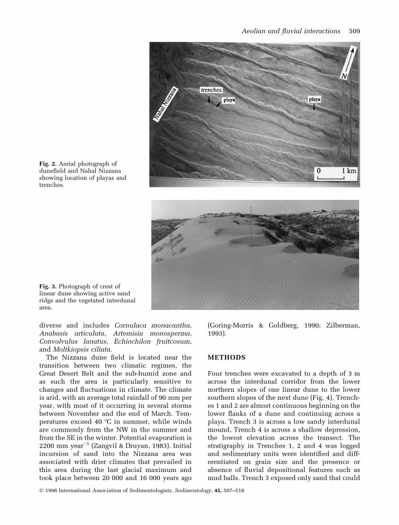
®eld is characterized by 15 m high and 100 mwide linear dunes, which trend east±west with300 m wide interdunal corridors. The easternboundary of the study area is the Nahal Nizzana,one of the major drainage systems in this area,which ¯ows normal to the direction of the longaxis of the linear dunes (Fig. 2). Most of the dunesurfaces are covered by a microbial crust thatstabilizes the surface, and some scattered vegeta-tion. Only the upper 5 m of the crest of the lineardune is active sand (Fig. 3). The Nizzana duneswere almost completely devegetated by overgraz-ing between 1967 and 1981 (Tsoar & Moller, 1986),and heavily grazed dunes in the northern Sinai,are completely devegetated, providing a continu-ing source of sand for the dunes at Nizzana.
The interdunal areas contain low linear dunes,closed depressions, and horizontal layers of siltand clay sediments, which have been describedas playa deposits (Yair, 1990). The playa depositsare widespread in the Nizzana area (Fig. 2),although their aerial extent decreases from southto north.
The crest of the dunes is characterized byscattered vegetation dominated by Stipagrostisscoparia. The interdunal vegetation is very
Fig. 1. Map showing location of the Nizzana Dune Field.
508 J. B. J. Harrison and A. Yair
Ó 1998 International Association of Sedimentologists, Sedimentology, 45, 507±518
diverse and includes Cornulaca monacantha,Anabasis articulata, Artemisia monosperma,Convolvulus lanatus, Echiochilon fruitcosum,and Moltkiopsis ciliata.
The Nizzana dune ®eld is located near thetransition between two climatic regimes, theGreat Desert Belt and the sub-humid zone andas such the area is particularly sensitive tochanges and ¯uctuations in climate. The climateis arid, with an average total rainfall of 90 mm peryear, with most of it occurring in several stormsbetween November and the end of March. Tem-peratures exceed 40 °C in summer, while windsare commonly from the NW in the summer andfrom the SE in the winter. Potential evaporation is2200 mm year)1 (Zangvil & Druyan, 1983). Initialincursion of sand into the Nizzana area wasassociated with drier climates that prevailed inthis area during the last glacial maximum andtook place between 20 000 and 16 000 years ago
(Goring-Morris & Goldberg, 1990; Zilberman,1993).
METHODS
Four trenches were excavated to a depth of 3 macross the interdunal corridor from the lowernorthern slopes of one linear dune to the lowersouthern slopes of the next dune (Fig. 4). Trench-es 1 and 2 are almost continuous beginning on thelower ¯anks of a dune and continuing across aplaya. Trench 3 is across a low sandy interdunalmound, Trench 4 is across a shallow depression,the lowest elevation across the transect. Thestratigraphy in Trenches 1, 2 and 4 was loggedand sedimentary units were identi®ed and diff-erentiated on grain size and the presence orabsence of ¯uvial depositional features such asmud balls. Trench 3 exposed only sand that could
Fig. 2. Aerial photograph ofdune®eld and Nahal Nizzanashowing location of playas andtrenches.
Fig. 3. Photograph of crest oflinear dune showing active sandridge and the vegetated interdunalarea.
Aeolian and ¯uvial interactions 509
Ó 1998 International Association of Sedimentologists, Sedimentology, 45, 507±518

not be separated into different sedimentary units.Four stratigraphic columns were described indetail (Fig. 4) and samples were taken every10 cm for analysis of particle size, electricalconductivity, gypsum and calcium carbonatecontent.
Samples were dispersed with 0á5% solution ofCalgon, then wet sieved to separate the sand andsilt + clay. The percentage silt and clay wasdetermined with a sedigraph. Electrical conduc-tivity was measured in a 1:1 extract on a Wheat-stone Bridge. Gypsum content was determined bythe Schlieff (1979) method. Calcium carbonatewas measured on a chittick apparatus, by dis-solving the carbonate in hydrochloric acid andmeasuring the carbon dioxide released (Dreima-nis, 1962).
STRATIGRAPHY IN THE TRENCHES
In Trenches 1, 2 and 4, interstrati®ed sand andsilt and clay layers were found (Figs 5 and 6).Four different types of stratigraphic layers werede®ned on grain size and internal stratigraphy. (1)A structureless, loose sand unit characterized bya very low content of silt plus clay (< 8%). Theorigin of these sands could be either aeolian or¯uvially reworked aeolian sands. (2) A secondsand unit, with a higher content of silt plus clay(10 and 15%). Occasional laminations and smallmud or silt balls, small clay-rich laminations orsmall rounded clasts indicate ¯uvial reworking.
(3) A structureless silty sand unit with up to 36%of silt plus clay, and (4) a silty clay unitcontaining between 75 and 90% silt plus clay.The clay content alone can make up to 20% ofthis unit. Silt-rich layers are invariably overlainby a clay-rich layer representing a ®ning upwardsequence of ¯uvially deposited sediments. Theclay layers have a strong prismatic structure, withiron staining and organic ®lms on the ped facesand occasional clusters of gypsum crystals. Sandis found in the cracks between the peds. InTrenches 1 and 2 the silt and clay rich layerscontained signi®cantly higher concentrations ofcalcium carbonate than the sand units (Table 1).In Trench 4, the lower sand units contain smallgravel clasts and a high concentration of snailshell fragments, which is re¯ected in the highercalcium carbonate values for these layers. How-ever, the carbonate values are still less than thoseof the silt and clay rich layers. The sands from thecrest of an adjacent linear dune contain >97%sand and are more similar to the structurelesssand units. Disconformities were recognizedwithin both groups of sand layers, but the layerson either side of the disconformity could not bedifferentiated on the basis of grain size, structureor bulk density.
The thickness of individual silt and clay layersin both Trench 2 and Trench 4 varies, with thegreatest thickness occurring at the midpoint ofeach layer (Fig. 7). This morphology indicatesthat the silt and clay layers were depositedin small depressions and not across the whole
Fig. 4. Cross-section of interdunal area near the trenches, showing location of the trenches, soils and TL dates.
510 J. B. J. Harrison and A. Yair
Ó 1998 International Association of Sedimentologists, Sedimentology, 45, 507±518

of the interdunal area at one time. A drill hole onthe ¯anks of the dune to a depth 3 m below that ofthe lowest playa unit in the trench did not hit anysilt or clay layer, providing further evidence ofthe restricted nature of the silt and clay units.
DISTINGUISHING BETWEEN PEDOGENICAND SEDIMENTARY FEATURES
Identi®cation of pedogenic features in a strati-graphic section is evidence of a signi®cant hiatusin the depositional record. In the arid environ-ment of Nizzana, the main evidence of pedogen-esis is the accumulation of calcium carbonate andsalts, particularly gypsum and sodium chloride(Yaalon & Ganor, 1975; Dan and Yaalon, 1982;Amit & Gerson, 1987; Gerson & Amit, 1987).Older soils have more strongly developed hori-zons of salt and dust accumulation. However, inan area with young sediments it may be dif®cultto distinguish between salt and dust accumula-tion caused by pedogenesis and that caused bysedimentary processes. The clay and silt-richlayers contain high levels of calcium carbonateand gypsum which could be interpreted as beingevidence of pedogenesis. However, microscopicobservation indicates that most of the carbonate isin the form of limestone grains. Similarly, spatialvariations in salinity within a stratigraphic unitcan be due to two different processes; (1) evap-oration of the water from a closed pond, or (2)subsequent accumulation of salts through pedo-
genic processes. Each of these processes willproduce a different spatial pattern of salinityvalues. Pedogenic processes produce similardepth pro®les of salt laterally, whereas theprogressive drying up of a small pond should bere¯ected in increasing salinity towards the centreof the pond. In order to determine which of theseprocesses was dominant in the silt and clay layersexposed in the trenches, the lower silty clay unitin Trench 1 + 2 (Fig. 5), was sampled at fourdifferent depths at six different points, to deter-mine lateral variation of salt concentration. Theconductivity at a depth of 0±10 cm increasessigni®cantly towards the centre of the palaeode-pression at 20 m (Fig. 8). The highest conductiv-ity is found in the small localized depression at9 m (Fig. 5). A similar pattern is observed for thenext two depth increments (10±15 cm and 15±20 cm). However, the conductivity of the nexttwo depth increments (20±30 cm and 30±40 cm)showed minor lateral variation. This re¯ects thegradual drying up of a small pond with increasingconcentration of salts in the centre of the pond.The strong lateral variation of conductivity indi-cates a lack of a pedogenic overprint suggestingthat this unit was not exposed at the surface for asigni®cant period of time.
Four stratigraphic sections, one from a pitexcavated in the dune above the trenches andthree from within the trenches were described indetail and intensively sampled to aid in identi®-cation of pedogenic features (Fig. 4). Evidence ofsoil formation within each stratigraphic section
Fig. 5. Sedimentary log of Trenches 1 and 2.
Aeolian and ¯uvial interactions 511
Ó 1998 International Association of Sedimentologists, Sedimentology, 45, 507±518

would help identify breaks within the deposi-tional record and also the age of the landsurface.Section 1 is on the north facing slope of a lineardune and it was chosen because it is close to apoint where a TL age was obtained at a depth a1á5 m (see below). Section 2 was located inTrench 2 where there are several alternatingsandy and ®ne grained stratigraphic units (Fig. 4and Fig. 5). This complex sequence was expectedto have a strong in¯uence on pedogenic processesand the apparent degree of soil development.Section 3 was located in the non-strati®ed sand inTrench 3. Comparison between the pedogenicfeatures in this section and section 1 allowestimation of the stability of the sand moundbetween trenches 2 and 4. Section 4 is located inTrench 4 in which former playa deposits areburied under 1 metre of sand. Comparison of thesoil development in the overlying sand unit tothat in section 1 allows an estimate to be made ofthe time of burial of the playa.
Section 1 on the ¯anks of the dune (Fig. 4) showsevidence of a very weakly developed soil. There isno signi®cant accumulation of clay or silt at anydepth and there is little differentiation of saltsdown the pro®le (Fig. 9). Two TL dates from thesand dune close to the location of this soil suggest
that it represents �5000 years of soil formationin a sandy parent material (Rendell et al.,1993). Section 2 contains several stratigraphicunits, which makes the evaluation of pedogenesismore dif®cult. There are distinct silt-rich andclay-rich layers but these are of sedimentary notpedogenic origin. The high electrical conductiv-ity and calcium carbonate accumulations occur inthe clay and silt layers indicating that the saltswere deposited with the silt and clay layers andare similarly not pedogenic in origin (Fig. 9).Although the calcium carbonate content of theclay rich layers is almost 35% there are noobvious secondary calcium carbonate crystals orother morphological evidence of pedogenic car-bonate. Thus the high carbonate content isinterpreted to be primary carbonate probablylimestone. Section 3 across a low linear dune(Fig. 4) shows a soil with a similar degree ofdevelopment as that in Section 1. There is noobvious horizonation and little variation of elec-trical conductivity with depth (Fig. 9). The soilhas developed entirely in sand. Section 4 con-tains several different stratigraphic units butunlike Section 2, there is evidence of pedogeniccalcium carbonate at two points; at 90 cm, justabove a silt layer (Fig. 6) and another at a depth of
Fig. 6. Sedimentary log of Trench 4.
512 J. B. J. Harrison and A. Yair
Ó 1998 International Association of Sedimentologists, Sedimentology, 45, 507±518

100 cm, also above a silt layer. Microscopicinvestigation reveals distinct carbonate crystalsand these accumulations are regarded as pedo-
genic in origin. The ®ne textured layers in thissection also have high carbonate values but nocalcium carbonate crystals were observed.
Table 1. Analytical data of stratigraphic sections 2 and 4.
CalciumSand Silt Clay EC carbonate
Depth (wt %) (wt %) (wt %) (mmohs/cm) (wt %)
Section 20±3 22á7 61á6 15á8 12á1 32á93±13 1á4 72á3 26á3 14á1 33á1
13±23 0á6 83á1 16á3 20á5 33á523±33 37á7 53á5 8á8 8á8 31á533-43 60á2 32á4 7á5 2á9 16á543±56 74á7 19á2 6á1 2á4 24á456±63 9á1 78á9 12á1 7á7 18á263±73 0á5 62á4 37á0 24á6 34á173±78 0á3 85á2 14á5 17á6 31á278±88 59á4 32á5 8á1 3á2 35á188±98 73á0 20á4 6á6 20á0 24á698±106 68á9 23á3 7á9 2á2 26á9
106±113 81á6 11á3 7á2 1á4 33á3113±118 3á5 62á7 33á2 16á5 31á8118±123 5á2 62á1 32á7 18á0 22á7123±128 15á1 71á4 13á5 10á1 17á5128±133 90á0 5á6 4á5 0á8 NA133±143 90á5 4á9 4á6 1á1 NA143±153 86á7 8á1 5á3 1á5 NA153±163 86á5 8á7 4á9 1á1 NA163±173 89á3 6á1 4á6 1á0 NA173±183 89á5 5á9 4á6 2á5 NA183±193 90á8 5á2 4á0 1á2 NA193±213 88á8 6á6 4á7 0á8 NA
Section 40±10 94á0 4á1 1á9 0á1 6á9
10±30 93á1 4á1 2á9 0á1 6á430±50 92á0 5á2 2á8 0á1 4á750±70 91á0 4á6 4á4 0á2 5á670±80 78á6 14á1 7á3 0á4 8á380±100 77á3 15á3 7á3 0á5 7á8
100±120 81á8 11á3 6á9 0á9 6á3120±135 2á5 58á3 39á2 4á4 23á2135±145 3á6 55á5 40á9 3á7 24á4145±150 1á0 73á3 25á7 4á2 19á6150±170 89á8 5á0 5á2 1á1 3á9170±195 95á1 2á5 2á4 0á8 2á6195±215 96á6 1á1 2á3 0á7 4á9215±229 96á7 1á6 1á7 0á9 8á1229±235 43á5 33á0 23á5 8á0 20á4235±255 79á2 12á0 8á8 1á0 13á1255±275 65á8 24á1 10á1 1á8 20á1275±295 32á1 52á0 15á9 2á3 21á6295±305 60á4 23á3 16á3 1á4 29á0305±325 73á8 13á2 13á0 0á6 37á2325±345 92á5 3á7 3á4 0á4 36á3345±365 74á3 15á9 9á7 0á6 21á7365±385 82á9 9á7 7á4 0á6 25á0
NA � Not analysed.EC � Electrical conductivity.
Aeolian and ¯uvial interactions 513
Ó 1998 International Association of Sedimentologists, Sedimentology, 45, 507±518

DISCUSSION
The origin of the silt plus clay layersin the interdunal deposits
The ®ne-grained layers are small, ®ning-upwardsequences indicating that they have been depo-sited in standing water. Runoff from the slopes ofthe dunes has been shown to occur underexperimental conditions in this area Yair (1990),and also under natural rainfall (Kidron, 1995).However, the volumes of runoff and the particlesizes of the sediment associated with a singleevent are not suf®cient to account for clay siltcouplets that are greater than 50 cm in thickness.Ripup clasts and mudballs (Fig. 10) in some sandlayers immediately below clay/silt couplets, theshape of the ®ne-grained units (Fig. 7), theobvious cutting of the underlying sedimentarylayers and the presence of gravels associated with
some of the ®ne-grained units, strongly indicate a¯uvial origin of the sediments. We assume thatthe mode of deposition in the interdunal areas issimilar to that described by Langford (1989) in theMojave River and in Medano Creek at the GreatSand Dunes National Monument. Overbank¯oodwaters from the Nahal Nizzana are probablycontained by the local topography, ®lling thelocal low points and hollows. Then as local sandbarriers are overtopped, small channels are in-cised into the sand and reworked sand is depo-sited in adjacent hollows. The interdunal area atNizzana is not smooth, but contains a number ofclosed depressions created by movement of smallsand ridges with a relief exceeding 2 m in places.Thus the stratigraphy of the ¯ood deposits is verystrongly controlled by the local topography andmay vary signi®cantly across the interdunal areaas well as along the corridor. For example, thestratigraphy in Trenches 1 and 2 is very different
Fig. 7. Silt/clay units in Trench 2showing the morphology of the ®ne-textured units.
Fig. 8. Changes in electroconductivity at four different depths along lower silty unit in Trench 2. The horizontaldistances correspond to those in Fig. 5.
514 J. B. J. Harrison and A. Yair
Ó 1998 International Association of Sedimentologists, Sedimentology, 45, 507±518

from that in Trench 4 even though they are thesame distance from the source of the sediments.Greater variation is observed with increasingdistance from the Nahal Nizzana. Close to thechannel, stacked sequences of alluvial depositsare observed, whereas in the trenches at thewestern end of the study area, only clay drapesare observed in the trenches. Thus the thicknessof interdunal deposits is not only a function of thelength of time that the interdunal area has beenexposed, as suggested by Ahlbrandt and Fryber-ger (1981), but also distance from the source of¯uvial sediments.
Timing of deposition
Six TL dates have been reported from the sands inthese trenches (Rendell et al., 1993). Two of thedates are from the lower ¯anks of the sand duneclose to Trenches 1 and 2 (Fig. 4); three others arefrom silt layers in Trench 2 and one more is from
the basal silt layer in Trench 4 (Figs 5 and 6). Theinversion of the dates in two places are ascribed toproblems in dose rate estimates; however, the twoages are not very different and the error rangesoverlap. Furthermore, samples SH 2á2 and SH 2á3(Fig. 4) were obtained from a section of alternatingsilt and clay-rich units, with no intervening sandlayers. The absence of sand in this section suggeststhat ¯ood waters did not rework aeolian sand toreach the depression where the playa depositsformed or else the surface of the playa was notcovered by sand in between depositional events.This suggests that the episodes of depositionoccurred over a short period of time. The lowerdate in Trench 2 is 15 000 years suggesting a hiatusof some 5000 years in the depositional record.There is no evidence of soil development in thelower silt unit nor in the sand layer that overlies it.Rates of soil development in this environment arestrongly in¯uenced by water movement, thus soildevelopment will occur faster in the free draining
Fig. 9. Depth pro®les of silt + clay and electroconductivity for the stratigraphic sections. The electroconductivity is asurrogate for soluble salt content.
Aeolian and ¯uvial interactions 515
Ó 1998 International Association of Sedimentologists, Sedimentology, 45, 507±518

sands than in the silty clay layers. There is minimalpedogenic overprint in the surface playa unit after9000 years therefore it would be dif®cult torecognize a hiatus of 5000 years by soil develop-ment alone, particularly in silt or clay layers.
The age of the basal unit in Trench 4 of 43 000years is much older than has been reported for thetiming of sand movement into this area (Zilber-man, 1993). The silt and sand units in this part ofthe trench are different from those found else-where in Trench 2 having a very high concentra-tion of reworked snail shells as well as some ®negravels. It is possible that these units representsheet ¯ood deposits rather than overbank ¯ooddeposits. Rendell et al. (1993) suggest that there isa distinct erosional break between the stratigra-phy in Trench 4 and Trenches 1 and 2. It is notnecessary to invoke an erosional event to explainthe lack of correlation in the stratigraphy betweenthe two trenches, when the depositional environ-ment is spatially variable. The presence of twopalaeosols in Trench 4 indicate there have beenbreaks in the depositional record for signi®cantperiods of time perhaps in the order of 5000 yearsor more.
Recent evolution of interdunal depressions
The few dates available for the deposition of theoverbank deposits indicate that ¯ooding oc-curred during the late Pleistocene. It has beenpostulated that this period experienced wetterconditions than occur today (Magaritz, 1986;Goodfriend & Magaritz, 1988). The present daychannel of the Nahal Nizzana is now some 3 mbelow its level. It is possible that the downcut-
ting is the reason that ¯ooding of the interdunalarea no longer occurs. Damming of streams bymoving sand has been reported in several placesin the Negev (Magaritz & Enzel, 1987; Zilberman,1993). It is also possible that the dunes atNizzana blocked the channel of the NahalNizzana and that ¯ood waters then formedseasonal lakes behind barriers. There is a greaterarea of playa surfaces in the southern part of thedune ®eld (Fig. 2) and no playa deposits arefound at the surface below the junction of theNahal Nizzana and Nahal Lavan. This suggeststhat if the Nahal Nizzana was blocked by sanddunes it occurred south of this junction. It is alsopossible that there was more than one damacross the Nahal Nizzana. Thus the ¯ood eventsmay not have been exceptionally large andfurthermore may have occurred during periodswhen the sands were mobile (i.e. under morearid conditions), as has been suggested for theNahal Sekher by Magaritz and Enzel (1987).
Today many of the playas are positive land-scape features isolated from the slopes of thedunes and also from the surrounding sands. Asthese units must have formed in depressions,landscape inversion has occurred indicating thatthere has been signi®cant erosion of the inter-dunal sands and playa sediments since thedeposition of the ®ne-grained sediments. Thepresence of terrace-like features cut into the sandalong the ¯anks of the dunes at several placesalong the interdunal corridor suggests that at leastsome of the erosion was due to a large ¯ood event.Sand eroded in such an event would have beendeposited in the interdunal areas across theborder in Egypt. The soil development in Section
Fig. 10. Mud and silt balls in unit 5.The presence of these features in apredominantly sand unit indicatethat the sand is a ¯uvial deposit.
516 J. B. J. Harrison and A. Yair
Ó 1998 International Association of Sedimentologists, Sedimentology, 45, 507±518

3, the low linear dune on the northern edge of theplaya between Trenches 1 and 2 and 4, is weak,with similar morphology to the soil found inSection 1. The TL dates close to the site of Section1 suggest that the soil has been forming for about5000 years, therefore the low linear dune atSection 3 is certainly no older than this. Most ofthe playa surfaces are disconnected from theadjacent dune slope. The development of rillsand small fans on eroded playa surfaces indicatethat runoff from the dune slopes and also from theplaya surfaces contributes to the ¯uvial erosion ofthe sand surrounding the playas. If this landscapeinversion occurred through ¯uvial erosion, itwould have happened after deposition of theuppermost playa unit in Trench 2, sometimearound the beginning of the Holocene. Thus theinterdunal area has been geomorphologicallyactive: during the late Pleistocene it was under-going aggradation, but since the Nahal Nizzanadowncut in the early Holocene (Zilberman, 1993)geomorphic activity has been predominantlyerosional (Fig. 11).
CONCLUSIONS
The interdunal area in this part of the Nizzanasands has been strongly in¯uenced by ¯uvialprocesses which operate at different scales. Large-scale ¯ooding of the interdunal depressionsresulted in erosion of sands and deposition ofsilt and clay ®ning upward sequences. On asmaller scale, runoff from the dune slopes andfrom the playas themselves result in erosion ofsand from the areas adjacent to the playas.
The vertical, stacked sequence of units in bothtrenches and the morphology of the playa unitsacross the interdunal area, suggest that thechannels or depressions in the interdunal areashave been stable over long periods of time,possibly 15 000 years for the depression inTrenches 1 and 2 and perhaps even longer forthat in Trench 4. The long term stability of theinterdunal depressions suggests that movement ofthe longitudinal dunes in Nizzana is predomi-nantly in a downwind direction without a stronglateral component as been described in longitu-dinal dunes elsewhere. Furthermore, if the mor-phology of the interdunal deposits is controlledin part by the linear dunes themselves by in¯u-encing the local wind regime, then the persis-tence of the interdunal areas re¯ects the long termpresence of the linear dunes themselves. Theaggradation of ®ne-textured layers in the inter-
dunal areas at Nizzana occurred throughout thelate Pleistocene and into the early Holocene.Since the deposition of the upper clay layer inTrenches 1 and 2, the interdunal area hasundergone a period of ¯uvial erosion with minorcontributions from aeolian erosion. This hasresulted in the formation of terraces cut into thesand along the margins of the interdunal area, andinversion of topography, leaving deposits fromformer depressions as positive relief features.
Thus, the wind regime, which strongly in¯u-enced the development of these dunes did notchange from the late Pleistocene to the present.The transition to the drier Holocene is expressedby incision in the Nahal Nizzana, a concomitantcessation of ¯uvial deposition in the interdunalareas and little change in the structure of thelongitudinal dunes. Furthermore, there are no
Fig. 11. Summary of the geomorphic history of the in-terdunal area.
Aeolian and ¯uvial interactions 517
Ó 1998 International Association of Sedimentologists, Sedimentology, 45, 507±518

large-scale changes in the dunes resulting fromthe periods of devegetation in the last 40 years.The deposition of the ¯uvial deposits does notnecessarily re¯ect a signi®cantly wetter period.Damming of the Nahal Nizzana by sand dunes inmore arid periods would result in ¯ooding of theinterdunal areas.
ACKNOWLEDGEMENTS
Dr Harrison was funded by a Golda Meir Fellow-ship from the Hebrew University of Jerusalem.The authors would like to thank the Arid Ecosys-tem Research Center of the Hebrew University ofJerusalem for logistical support for this project,and Drs N. Lancaster, G. Kocurek and P. Mozleyfor helpful reviews of earlier drafts of this paper.We are also grateful for the help with thelaboratory analyses from I. Ziha.
REFERENCES
Ahlbrandt, T.S. and Fryberger, S.G. (1981) Sedimentaryfeatures and signi®cance of interdune deposits. Spec.Publ. Soc. econ. Paleont. Miner., 31, 293±314.
Amit, R. and Gerson, R. (1987) The evolution of Ho-locene Reg (gravelly) soils in deserts ± an examplefrom the Dead Sea region. Catena, 13, 59±79.
Dan, J. and Yaalon, D.H. (1982) Automorphic salinesoils in Israel. Catena supplement 1, 103±115.
Dreimanis, A. (1962) Quantitative gasometric determi-nation of calcite and dolomite by using Chittick ap-partus. J. sedim. Petrol., 32, 3. 520±529.
Gerson, R. and Amit, R. (1987) Rates and modes of dustaccretion and deposition in an arid region-the Negev,Israel. In: Desert Sediments: Ancient and modern(eds L. Frostick and I. Reid.), Spec Publ. geol. Soc.London. 157±169.
Goring Morris, N. and Goldberg, P. (1990) Late Qua-ternary dune incursions in the southern Levant,chronology and paleoenvironment. Quaternary In-ternational, 5, 115±137.
Goodfriend, G.A. and Margaritz, M. (1988) Paleosolsand late Pleistocene rainfall ¯uctuations in the Negevdesert. Nature, 332, 144±146.
Hesp, P., Hyde, R., Hesp, V. and Zhengyu, Q. (1989)Longitudinal dunes can move sideways. Earth Surf.Processes. Landforms, 14, 447±451.
Issar, A., Karnieli, Bruins and Gilead, I. (1984) TheQuaternary geology and hydrology of Sede Zin, Ne-gev, Israel. Israel J. Earth Sci., 33, 34±42.
Kocurek, G. (1981) Signi®cance of interdune depositsand bounding surfaces in eolian dune sands. Sedi-mentology, 28, 753±758.
Lancaster, N. and Teller, J.T. (1988) Interdune depositsof the Namib Sand Sea. Sediment. Geol., 55, 91±107.
Langford, R.P. (1989) Fluvial±aeolian interactions: PartI, modern systems. Sedimentology, 36, 1023±1035.
Langford, R.P. and Chan, M.A. (1989) Fluvial±eolianinteractions: Part II, ancient systems. Sedimentology,36, 1037±1051.
Magaritz, M. (1986) Environmental change records inthe upper Pleistocene along the desert boundary,southern Israel. Paleogeogr. Paleoclim. Paleoecol.,53, 9±16.
Magaritz, M. and Enzel, Y. (1987) Standing-water de-posits as indicators of late Quaternary dune migra-tions in the northwestern Negev, Israel. ClimateChange, 16, 307±318.
Rendell H.M., Yair, A. and Tsoar, H. (1993) Thermo-luminescence dating of periods of sand movementand linear dune formation in the northern Negev,Israel. In: The Dynamics and Environmental contextof Aeolian Sedimentary Systems (ed. K. Pye), Spec.Publ. Geol. Soc., 72, 69±74.
Rubin, D.M. and Hunter, R.E. (1985) Why deposits oflongitudinal dunes are rarely recognized in the geo-logic record. Sedimentology, 32, 147±157.
Rubin, D.M. (1990) Lateral migration of linear dunes inthe Strzelecki Desert, Australia. Earth Surf. Process.Landforms, 15, 1±14.
Rutin, J. (1992) Geomorphic activity of rabbits on acoastal sand dune, De Blink dunes, the Netherlands.Earth Surf. Process. Landforms, 17, 85±94.
Schleiff, V. (1979) Determination of gypsum by mea-surement of electrical conductivity in water extractof soils in Saudi Arabia. Mitt. Deutsch Bodenk. Ge-sellsch., 2, 993±1000.
Tsoar, H. and Yaalon, D.H. (1983) De¯ection of sandmovement on a sinuous longitudinal (sief) dune: Useof ¯uorescent dye as a tracer. Sediment. Geol., 36,25±39.
Tsoar, H. and Moller, J.T. (1986) The role of vegetationin the formation of linear sand dunes. In: AeolianGeomorphology (ed. W. G. Nickling), Allen and Un-win, Boston, 79±85.
Yaalon, D.H. and Ganor, E. (1975) Rates of aeolian dustaccretion in the Mediterranean and desert fringe ofIsrael. IXeme Cong. Int. Sediment., 169±174.
Yair, A. (1990) Runoff generation in a sandy area ± TheNizzana Sands, western Negev, Israel. Earth Surf.Process. Landforms, 15, 597±609.
Zangvil, A. and Druyan, P. (1983) Meterological datafor Sede Boqer. Desert Meterological Papers, Ser. A,no. Blaustein for Desert Research, Sede Boqer, Israel,25 pp.
Zilberman, E. (1993) The late Pleistocene sequence ofthe northwestern Negev ¯ood plains ± A key to re-constructing the paleoclimate of southern Israel inthe last glacial. Israel J. Earth Sci., 41, 155±167.
Manuscript received 29 October 1993; revision accept-ed 8 July 1997.
518 J. B. J. Harrison and A. Yair
Ó 1998 International Association of Sedimentologists, Sedimentology, 45, 507±518