large river floods may occur any time · large river floods may occur any time ... and its larger...
TRANSCRIPT


Large river floods may occur any time between November and April in successive years, or not occur at all for many years.
Floods are Destructive and Costly
The National Weather Service has declared flooding the single most destructive natural hazard in the country. Even in desert areas like Nevada, Arizona and southern California, river floods and flash floods kill people and cause millions of dollars in property damage nearly every year. In Washoe County, as in many other areas of the West, we have built residential communities on river flood plains and alluvial fans.
Residents and business owners are urged to prepare for floods before they happen. Because years and even decades can pass between major floods, citizens are often caught unaware when they do occur.
Residents of Washoe County are vulnerable to two kinds of flooding. We have major winter floods on the Truckee River and its larger tributaries such as Steamboat Creek and the North Truckee Drain. We also have summer flash floods on small creeks, washes and alluvial fans.
Alluvial Fans Produce Unpredictable Floods
As a flash flood rushes out of a confined (concave) canyon at the top (apex) of a fan, it's contained for a short distance in a single, high-velocity channel. (See illustration) This channel, like the ravine upstream, is a high-hazard flood zone, threatening lives and structures in its path. In areas where the channel is not deeply entrenched, it can become clogged with debris not far below the apex, and cut a new path on the convex surface of the fan. This makes alluvial fan flooding much less predictable than valley bottom flooding.
Where canyons are close together, their fans tend to merge. These fans are sometimes hard to recognize because they're not always cone-shaped.
According to the FEMA manual, "Alluvial Fans: Hazards and Management" (FEMA, 1989) it's difficult to predict how severe the hazards will be for any given neighborhood. Since a channel can change location during a flood, almost all neighborhoods on fans are in a potential flood path. While predicted flood depths may average a foot or less over much of the fan, a rampaging flood can erode a gully 1 to more than 10-feet deep on one lot and deposit the sediment several feed deep a short distance down the street. Flash floods can also deposit large boulders, tree trunks and other debris on the fan surface below Sierra canyons. In the arid West, there's a tendency to underestimate the potential and severity of flash flood events on alluvial fans.
“There is a critical need to provide guidance to communities,
developers and citizens on how to accommodate growth while
protecting life and property from flood hazards on alluvial fans.”
Summer Flash Floods Drench Suddenly
A flash flood is a local flood of great volume and short duration. Small creeks and the usually dry "washes" that flow into the Truckee Meadows and surrounding valleys from nearby mountains are susceptible to summer flash floods. A wall of water can rush onto the valley floor from canyons or ravines just minutes or hours after a summer thundershower has drenched the headwaters a few miles upstream.
After floods emerge from a canyon, they deposit sediments that accumulate over time to form alluvial fans. While gently sloping fans at the foot of the mountains provide attractive development sites, they can also harbor severe flood hazards for those who live there.
The Federal Emergency Management Agency (FEMA) has identified a "critical need to provide guidance to communities, developers and citizens on how to safely accommodate growth while protecting life and property from flood hazards on alluvial fans." (FEMA 165, 1989)
Streams and Drainages Which Have Flash Flood Histories
1. Galena Creek 2. Thomas Creek 3. Steamboat Creek 4. Evans Creek (both Reno locations) 5. Whites Creek 6. Peavine Creek and Drainages 7. Skyline Wash 8. Browns Creek 9. Jones Creek 10. Ophir Creek 11. Hunter Creek 12. Dry Creek 13. Hidden Valley Drainages 14. Dog Valley Creek 15. Alum Creek 16. Spanish Creek 17. Golden Valley 18. Sun Valley 19. Lemmon Valley 20. Cold Springs 21. Bailey Canyon Creek 22. Jumbo Grade 23. West Washoe Valley 24. Incline Villages

Beware of Winter Floods on the Truckee River
The famous New Year's flood of 1997 was a classic winter flood on the Truckee River. It flooded low-lying floodplains adjacent to the river and its major tributaries such as Steamboat Creek.
It caused more than 450 million dollars in damage, closing the Reno-Tahoe airport and shutting down businesses for days and weeks. The flood also caused environmental damage when sediments, urban pollutants and flood debris were washed downstream.
Winter floods of the Truckee River have occurred many times since Reno and Sparks were founded. Major floods occurred in the Truckee Meadows in 1862, 1875, 1890, 1904, 1907, 1928, 1937, 1943, 1950, 1955, 1963, 1986 and 1997.
The primary cause of river flooding has always been winter rainstorms that saturate and melt the Sierra snow pack at elevations between 4,500 and 8,000 feet or higher. Though most winter storms bring snow to elevations above 6,000 feet, a series of warm storms occasionally dumps rain at higher elevations. The January 1997 floods were caused by several warm storms, which swept into the Sierra Nevada from the Hawaiian Islands and rained on a heavy snow pack. This weather pattern is called "The Pineapple Connection" or "The Pineapple Express."
Winter flooding by rain-on-snow weather events will continue to cause damage to urbanized valley floors in Reno, Sparks and other low-lying Washoe County communities. Large river floods may occur any time between November and April in successive years, or not occur at all for many years.

“Floods and Flash Floods are the #1 weather-related killer in the United States,”
National Weather Service
Truckee Meadows has a Long Flash Flood History
Flash floods have occurred on most small streams, drainages and washes in the Truckee Meadows vicinity. Detailed accounts of many of these cloudburst floods have described them as "walls of water." It's interesting to note that in several accounts, flooding resulted from the merging of convective thunderstorm cloud cells. A rainfall rate as high as 10 inches an hour was estimated for short durations in one particular instance.
100-Year Floods Can Happen Any Year
The most dangerous flood zones have an A, AE or AO designation. They are commonly referred to as 100-year flood zones, Special Flood Hazard Areas (SFHA :) or regulatory floodplains. Residents in these zones are required to buy flood insurance if they have federally assisted financing. See the map on pages 6 & 7 for a general delineation of flood-zone areas.
The 100-year flood is the accepted national standard used to designate regulatory floodplains. A 100-year flood is not a flood that happens once every 100 years. Instead, it's a flood so large it has a 1-percent chance of occurring in any year. The term "100-year" refers to the size of a flood, not how often it occurs. Decades may go by without a 100-year flood. On the other hand, several 100-year floods could occur within a few years.
A Sampling of Major Summer Flash Floods
July 1869: A cloudburst flood resulted from a heavy thunderstorm. Intense rain accompanied by hail resulted in flooding 2-feet deep from Browns School to Huffaker School in the southern Truckee Meadows.
August 15, 1878: Torrential rain (a "monster cloudburst") fell for 3 hours on watersheds southwest of Reno. Thomas Creek turned into a raging torrent 400-feet wide and 3-feet deep, gouging its channel to bedrock in many locations.
July 18-26, 1913: An almost daily occurrence of thunderstorms produced flooding from canyons draining into the Truckee River west of Reno. The most severely affected streams were Hunter Creek and Alum Creek. Galena and Browns Creeks poured a "solid sheet of water" into Pleasant Valley. An automobile mired on the highway was buried under a 30-foot thick deposit of flood debris.
July 29, 1952: Floodwater from Galena Creek inundated hayfields in Pleasant Valley and deposited a; thick layer of silt and sediment, damaging or destroying most of the baled hay in the fields. Highway 395 was blocked, and miles of fence and irrigation ditches were destroyed.
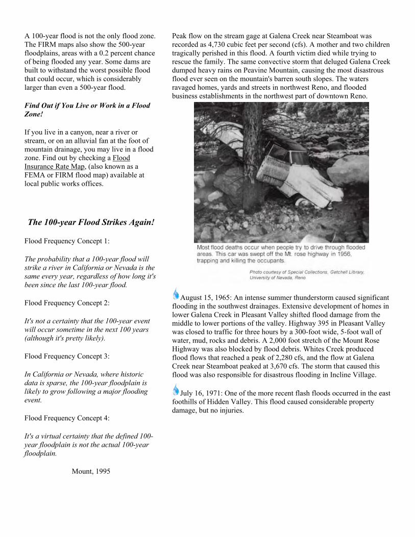
July 20, 1956: A wall of water, reportedly 10 feet high, rushed down Galena Creek, washing several cars off the Mount Rose Highway.
A 100-year flood is not the only flood zone. The FIRM maps also show the 500-year floodplains, areas with a 0.2 percent chance of being flooded any year. Some dams are built to withstand the worst possible flood that could occur, which is considerably larger than even a 500-year flood.
Find Out if You Live or Work in a Flood Zone!
If you live in a canyon, near a river or stream, or on an alluvial fan at the foot of mountain drainage, you may live in a flood zone. Find out by checking a Flood Insurance Rate Map, (also known as a FEMA or FIRM flood map) available at local public works offices.
The 100-year Flood Strikes Again!
Flood Frequency Concept 1:
The probability that a 100-year flood will strike a river in California or Nevada is the same every year, regardless of how long it's been since the last 100-year flood.
Flood Frequency Concept 2:
It's not a certainty that the 100-year event will occur sometime in the next 100 years (although it's pretty likely).
Flood Frequency Concept 3:
In California or Nevada, where historic data is sparse, the 100-year floodplain is likely to grow following a major flooding event.
Flood Frequency Concept 4:
It's a virtual certainty that the defined 100-year floodplain is not the actual 100-year floodplain.
Mount, 1995
Peak flow on the stream gage at Galena Creek near Steamboat was recorded as 4,730 cubic feet per second (cfs). A mother and two children tragically perished in this flood. A fourth victim died while trying to rescue the family. The same convective storm that deluged Galena Creek dumped heavy rains on Peavine Mountain, causing the most disastrous flood ever seen on the mountain's barren south slopes. The waters ravaged homes, yards and streets in northwest Reno, and flooded business establishments in the northwest part of downtown Reno.
August 15, 1965: An intense summer thunderstorm caused significant flooding in the southwest drainages. Extensive development of homes in lower Galena Creek in Pleasant Valley shifted flood damage from the middle to lower portions of the valley. Highway 395 in Pleasant Valley was closed to traffic for three hours by a 300-foot wide, 5-foot wall of water, mud, rocks and debris. A 2,000 foot stretch of the Mount Rose Highway was also blocked by flood debris. Whites Creek produced flood flows that reached a peak of 2,280 cfs, and the flow at Galena Creek near Steamboat peaked at 3,670 cfs. The storm that caused this flood was also responsible for disastrous flooding in Incline Village.
July 16, 1971: One of the more recent flash floods occurred in the east foothills of Hidden Valley. This flood caused considerable property damage, but no injuries.

Let Flood Insurance Protect Your Home
It's not possible to completely protect all areas subject to flooding with flood-control structures. Recognizing the importance of a nonstructural approach to reducing flood losses, Congress created the National Flood Insurance Program (NFIP) in 1968. Its purpose is to provide affordable insurance forecasting floodplain development and to protect future development from flood losses. FEMA administers this program.
Washoe County participates in the NFIR It has adopted floodplain ordinance that regulates development within the 100-year floodplain, or SFHA. This area is shown as Zone A, AK, AH or AO on the maps. A floodplain development permit is required for new construction, substantial improvements to existing buildings, and any other man-made changes to floodplains, such as mining, dredging, filling, grading, paving, excavation or drilling operations, or storage of equipment or materials.
Because Washoe County participates in the NFIP, flood insurance is available to residents as financial protection against flood losses. Flood insurance can be purchased on any building from a licensed insurance agent. Some insurance companies issue flood insurance under their own names, but it's still federal flood insurance governed by the requirements of the NFIR.
By law, mortgage lenders must require the purchase of flood insurance as a condition of any federally regulated or guaranteed loan to buy, construct, repair or improve a building that is located in a SFHA.
You may want to buy flood insurance even if your house is not in a 100-year flood zone. Some floodplains, designated "Zone X-shaded," can be hazardous, though not as hazardous as 100-year floodplains. Also rivers are not the only source of flooding. Alteration of natural drainage patterns and inadequate or blocked storm drains can flood areas not previously identified as flood-prone. Regardless of where your property is located, it's to your advantage to educate yourself about flood and drainage conditions in your area. Flood insurance rates are based upon the flood risk to a structure. Rates reflect location and how well a building is protected from flood damage.

In Washoe County, new construction and substantial improvements to structures in a SFHA must have finished floors elevated foot or more above the predicted depth of the 100-year flood. Before building or repairing a structure in the flood zone, check with your insurance agent to get the cost of flood insurance for the completed project. If you're required to purchase a flood insurance policy for any reason, it's critical to maintain that coverage so your loan is not jeopardized and you can qualify for disaster assistance.
Reminder: Federally subsidized flood insurance | does not cover the contents of a home unless you purchase additional coverage for that purpose. Check the policy to see if it covers the contents. For information on flood insurance, contact your insurance agent or the NFIP insurance contractor, Computer Sciences Corporation, at (800) 638-6620. Lenders and insurance agents desiring information on training seminars and technical issues should call (713) 531-5990.
Call these Emergency Numbers for Help If you have a life-threatening emergency, call 911
Washoe County Emergency Management (775) 328-2095 City of Reno Emergency Management (775) 334-2300 City of Sparks Emergency Management (775) 353-1619
How to Prepare for a Flood Even though county and city governments are preparing for disasters such as earthquakes and floods, you need to be ready to respond to these emergencies as well. Because power, water, gas and even transportation routes can be cut off during a disaster, you and your family should be prepared to be self-sufficient for at least three days.
Here are come tips on preparing for a flood:
1. Find out if you are in a Flood-Prone Area.
Call or visit one of the offices listed on the back page to check the Flood Insurance Rate Map for your neighborhood. Find out if you live in a Zone A (SFHA) or a less hazardous Zone X-shaded flood zone. Identify dams in your area and determine whether they pose a hazard. If you live in a flood zone, consider buying flood insurance. There is usually a five-to 30-day waiting period before it takes effect. Insurance rates t end to be from $400 to $1,000 annually.
2. Learn How to Use Emergency Information.
Check your local TV and radio stations for more information. Purchase a National Oceanic and Atmospheric Administration (NOAA) Weather Radio, one with battery backup and a tone-alert feature that automatically alerts you when the National Weather Service issues a flood watch or warning.
3. Know the Terms Used to Describe Flooding Dangers.
Flood Watch-Flooding is possible. Stay tuned to NOAA radio, commercial radio or television for additional information.
Flash Flood Watch-Flash flooding is possible. Move to higher ground. A flash flood could occur without warning.
Flood Warning-Flooding is occurring or will occur soon. If advised to evacuate do so immediately.
Flash Flood Warning-A flash flood is occurring. Go to higher ground on foot immediately.
Urban and Small-Stream Advisory or Warning-Flooding of small streams, streets and low-lying areas is occurring.

4. Create A Family Disaster Plan.
Talk to your family about flooding and other disasters. Determine the safest routes to high ground from home, school and work locations. Make sure everyone knows exactly where to go if ordered to evacuate.
Plan a place to meet your family in case you become separated in a disaster and can't return home.
Choose a family contact phone number (preferably someone living out-of-state who's easy to reach by phone) to let other family members know where you are. After a disaster, it's often easier to call long distance.
Talk to your neighbors about helping each other in an emergency. Determine special help needed for elderly or disabled people.
Plan how to take care of pets.
Teach children how and when to call 911 for emergency help.
5. Assemble a Family Disaster Supplies Kit. Keep this stocked for any emergency, not just a flood. Stock enough supplies for at least three days. Place the ones you'll most likely need for an evacuation in a portable, waterproof container. Here are the basics your kit should include:
Drinking water in nonbreakable containers. Store 1 gallon per person for each day. Have at least a three-day supply.
Three days of food. Select items that require no refrigeration, preparation or cooking and little or not water. Include canned foods and high-energy foods such as crackers, peanut butter and jelly, etc. Pack baby food if needed.
First-Aid Kit. Keep one at home and one in each car. Include bandages, moist towelettes, soap, scissors, tweezers, pain/fever medication, antiseptic, thermometer, etc. Include prescribed medications.
Clothing. Include a complete change of clothes for each person as well as rain gear, wool hat, gloves and waterproof boots.
Bedding. Pack blankets, sleeping bags, pads and ground cloths.
Tools and Supplies. Include flashlights, battery-powered radio with extra batteries, eating utensils, knife, can opener, rain tarp or tent, matches, toilet paper, towels, some cash, eyeglasses, etc.

Note: These maps are based on information available from Washoe
County and from Current (1994) Flood Zone Maps. However, because of
the scale, they represent only approximate flood zone locations. For
detailed information about your neighborhood, please study the firm
maps themselves, which are located at the agencies listed below.

What to do During a Flood
1. Keep a battery-powered radio: It's for emergency use in case your electric power is cut off.
2. When outside the house, remember, floods are deceptive: Avoid flooded roads and don't attempt to walk or drive through floodwaters.
3. If, and only if time permits, take these precautionary steps:
• Turn off all utilities at the main power switch and close the main gas valve if evacuation is likely.
• Don't touch any electrical equipment unless it's in a dry area and you're standing on a piece of dry wood wearing rubber gloves and rubber-soled boots or shoes.
• Move valuable papers, furs, jewelry, clothing and other contents to upper floors or higher elevations.
• Fill bathtubs, sinks and jugs with clean water in case the regular supply is contaminated. Sanitize these items by rinsing with bleach.
• Board up windows or protect them with storm shutters.
• Bring outdoor possessions inside the house or tie them down securely. This includes lawn furniture, garbage cans, tools, signs and other movable objects that could be swept away or hurled about.
4. If it's safe to evacuate by car, consider the following:
• Stock the car with nonperishable foods (canned goods), a plastic container of water, blankets, first-aid kit, flashlights, dry clothing, and any special medication needed by your family. See family disaster supplies kit.
• Keep the gas tank at least half full since gas pumps at service stations will not be working if electricity is cut off.
• Don't drive where roads are flooded. Parts of the
road may already be washed out. If your car stalls in a flooded area, quickly abandon it. Floodwaters can rise rapidly and sweep a car (and its occupants) away. Many deaths have resulted from attempts to move stalled vehicles,
5. If you're caught in your home by rising water, move to the second floor and, if necessary, to the roof: • Take warm clothing, a flashlight and a portable
radio. • Wait for help - don't try to swim to safety. Rescue
teams will be looking for you.
What to do After a Flood 1. Prior to entering a building:
• Check for structural damage. Make sure it's not in danger of collapsing.
• Turn off any outside gas or electricity lines at the meter or tank. If you smell gas, call the utility company immediately.
2. Upon entering the building: Use a battery-operated flashlight, not an open flame, as a source of light. Gas may still be trapped inside.
3. Watch for downed electrical wires:
• Make certain the main power switch is turned off. • Do not turn on any lights or appliances until an
electrician has checked for short circuits.
4. Cover broken windows: Cover holes in the roof or walls to prevent further weather damage.
5. Proceed with immediate clean-up measures:
• Perishable food items pose a health risk. Throw out any fresh food and medicines that have come in contact with floodwaters.

• For the insurance claim, the items should be listed and photographed before discarding.
6. Be careful of water for drinking and food preparation:
• Tap water should be used only if the public water system has been declared safe.
• In an emergency, water can be obtained by draining a hot water tank or melting ice cubes.
7. Take pictures of the damage to your building and its contents:
• Refrigerators, sofas and other appliances should be hosed off and kept for the adjuster's inspection.
• Use a household cleanser to clean items that will be kept.
• Any partially damaged items should be dried and aired. The adjuster will make recommendations as to repair or disposal.
8. All wet items must be thoroughly cleaned and dried: All equipment must be repaired and cleaned before use.
9. Be aware that roads, walkways and staircases may be undermined by floodwaters: They should be checked before use to make sure they're safe. Take pictures, etc.
NOAA WEATHER RADIO - BUY ONE NOW! Up-to-the-Minute Flood Reports and Much More
NOAA Weather Radio is not just for emergencies. It's a round-the-clock source of weather reports and information that helps you in preparing for the day ahead. When trouble arises, there is no substitute for NOAA Weather Radio. The constantly updated broadcasts provide dependable information when you need it mast. The network offers listeners vital information about where to turn for help after severe stows and other emergencies occur. The radios come in many sizes with variety of functions. Pocket radios can be used for outdoor activities, or carried on family trips. Many of the radios receive a tone-alert signal, triggering a built-in alarm that warns listeners of severe weather announcements in their area. Weather information available on NOAA Weather Radio in western Nevada and eastern California originates from the National Weather Advice office in Reno. The broadcast cycle repeats every 4 to 6 minutes, depending on weather conditions. Information on NOAA Weather Radio includes:
1. Flood watches or warnings affecting the Truckee, Carson, Walker, Susan or lower Humboldt Rivers.
2. Hazardous weather watches, warnings or advisories affecting the area.
3. Other emergency information as requested by local law enforcement, fire or emergency management
agencies.
4. Short-term forecast of expected weather conditions over the next 1 to 6 hours.
5. Latest regional forecasts for the next five days.
6. Latest regional weather observations (updated hourly).

During the New Year’s flood of 1997, downtown Reno and the Sparks industrial area were devastated by severe flooding. Such floods
will undoubtedly continue to occur.
How People's Activities Can Make Floods More Destructive
In the lower reaches of a watershed, (a river basin), rivers meander through bottom lands that are flat and moist. When floods occur, natural rivers overflow their banks and occupy the bottom lands, also known as the river's floodplain. As the water spreads out, it loses velocity and erosive force and does relatively little damage to the environment or an occasional road or structure.
However, if we "claim" the floodplain by building levees or floodwalls or straightening and channeling the river, we concentrate tremendous energy and destructive force in the channel. By forcing a channel to convey large volumes of water
that normally spread out over a wide area, we make the current flow deeper and faster. The river either breaks through its levees or, if it stays within the artificial channel long enough, it can severely flood the community downstream.
In addition, when people compact soil and construct impervious surfaces such as roads, parking lots and rooftops, the rainwater that would have soaked into the soil runs off the land rapidly into the nearest creek. When we urbanize land, we construct storm water collection systems that speed up the flow of runoff into rivers and streams. When we increase storm flows, or "peak flows," we also increase the likelihood of flooding downstream. Over the last 130 years, we have made many changes in the natural function of the Truckee River. We channelized the river in places and lowered its channel level by dynamiting the Vista Reef in the early 1960s. We built commercial, industrial and residential structures in many parts of the natural flood-plain.
By building reservoirs such as Prosser Boca, Stampede and Martis Creek in the Sierra Nevada, we lessened the impact of winter floods on the Truckee Meadows. However, during the New Year's flood of 1997-in spite of the dams that were constructed upstream-downtown Reno and the Sparks industrial area were devastated by severe flooding. Such floods will undoubtedly continue to occur. Some atmospheric scientists predict that if the earth's climate continues to warm, the Sierra Nevada win receive more of its winter precipitation in rainstorms. This may increase the probability and frequency of major flood events on the Truckee River.
Because flood hazards will not go away and may indeed increase, we must consider ways to prepare for future flooding. These strategies include watershed management and floodplain management, using both structural and nonstructural flood-control methods.

We Need Coordinated Management Throughout the Watershed
In many parts of the country, residents and government agencies are cooperating in efforts to improve land management throughout entire watersheds. Protecting the land, the vegetation and small steams could benefit It flood hazards in the Truckee River water-shed.
During the l990s, most work in the watershed has focused on improving water quality in the ever. Since Reno and Sparks already have a state-of-the-art wastewater treatment plant, recent efforts have emphasized the use of best management practices (BMPs) to reduce polluted runoff and BMPs are methods we can use to restore natural watershed
Best Management Practices (BMPs) can help reduce flooding in watersheds:
• Erosion control • Vegetation of stream banks • Protection of natural wetlands • Restoration of disturbed wetlands • Runoff infiltration systems • Construction practices to preserve and
restore soil and vegetation • Flood diversion or bypass structures • Flood: retention basins which allow
flood water to recharge into the ground
functions. Used on both private and public lands, they can increase the watershed's ability to soak up water like a sponge, thereby reducing peak flows in rivers and streams. (See box at left). The Washoe-Storey Conservation District recently developed a restoration plan for Steamboat Creek. This plan urges implementation of erosion control BMPs and restoration of wetlands and riparian (stream-side) vegetation wherever possible. Similar efforts, if earned out in all parts of the Truckee River watershed, would not only improve water quality but also reduce flood flows from future storms. Government agencies can work to reduce the impact of roads.
We can do a Better job of Managing our Floodplains
Floodplain management refers to any program or action that reduces flood losses through the wise use of floodplains. Local governments have the primary responsibility for establishing floodplain management programs. They have the authority to guide land use and development within their jurisdictions, and are usually familiar with flooding problems and what might be done to solve them.
State and federal governments can play a significant role in helping communities develop and implement floodplain management programs by providing the financial and technical assistance local governments might not otherwise have. In Nevada, call the Nevada Division of Water Planning, 1550 East College Parkway, Suite 142, Carson City, NV 89706, (775) 687-3600, or your local government public works office.
Citizens also have a responsibility to do their part to make floodplain management programs effective. Here's how:
1. The first rule is simple: stay out of floodplain! If you don't have to rebuild there, don't. You will only be putting the property and its future residents in danger.

2. The second rule of floodplain management is to learn about the flood hazards in your area. If you're located in the flood-plain, learn what you can do to protect your property from losses. Once a flood zone has been identified, there are two ways to reduce losses within the floodplain-structural measures and nonstructural measures. (See box below). We Need Both Structural and Nonstructural Methods of Flood Control
In the Truckee River watershed, property owners have been protected by costly flood-control dams, levees and channel improvements. After the record floods of 1950 and 1955, four reservoirs were built upstream. Flood experts credited these structures with preventing a worse flood in the Truckee Meadows in 1997.
In the '90s however, there's a growing body of evidence that structural methods of flood control must be complemented by non-structural methods to achieve reduced flood hazards and improved water quality and habitat goals. (See box below.) The new science of floodplain management encourages
The Two Main Types of Flood-Control Measures
Structural
Flood control dams and reservoirs Levees and dikes
Channel improvements Lined floodway channels
Nonstructural
Comprehensive floodplain management Land-use planning and zoning
Keeping agriculture in floodplains Land acquisition in floodplain areas
Forecasting, warning and emergency preparedness Flood Insurance
Flood proofing of structures nonstructural solutions, such as zoning, to prevent construction and housing in flood-hazard areas. You can play a vital role by providing input to local and regional planning efforts. If you support the goals of agencies to improve watershed and floodplain management, your children will be rewarded with safer communities in the 21st Century.
Getting streams and creeks to function as complex water ecosystems is a powerful tool that can reduce the velocity and volume of flows during storm events. Some flood experts in cities such as Denver have opted to give their rivers more room to roam. Flood-control districts throughout the country are acquiring land in critical floodplain areas, razing structures, and returning the land to parks and wildlife habitat areas. This "river corridor" approach can reduce flood hazards while simultaneously increasing the aesthetic appeal of the river as a magnet for tourists and residents.
In rural areas, farmers are being encouraged to keep floodplain land in agricultural production by creating conservation easements. This may be the single most cost-effective way to reduce flood hazards in a watershed. The Army Corps of Engineers has been reevaluating flooding problems along the Truckee since 1996. The Corps is engaged in studies to improve flood control and recreation, and restore and improve the natural resources along the river. The Washoe County Regional Water Planning Commission is working on a flood
You can play a vital role by providing input to local and regional planning efforts. If you
support the goals of agencies to improve watershed and floodplain management, our children will be rewarded
with safer communities in the 21st Century.
-management plan as part of their Regional Water Plan. Call Washoe County Department of Water Resources for more details, (775) 954-4600.
Act Now to Prepare for Floods
"Flood Facts" has given you a number of ways you can prepare for flooding. You can educate yourself and your family. You can set up a plan to protect your home and prepare yourself for a flood. You can get involved in focal or regional efforts to lessen the damage of future floods. Public participation in government planning efforts is the best way to work toward long-term solutions of flood problems. Whatever measures you decide to take, act now! Use this guide so you'll be ready the next time a flood hits the Truckee Meadows.