landscape conservation in the amazon...
TRANSCRIPT

WORKING PAPER NO. 34 JUNE 2008
LANDSCAPE CONSERVATION IN THE AMAZON REGION: PROGRESS AND LESSONSBy Michael Painter, Ana Rita Alves, Carolina Bertsch, Richard Bodmer, Oscar Castillo, Avecita Chicchón, Félix Daza, Fernanda Marques, Andrew Noss, Lilian Painter, Claudia Pereira de Deus, Pablo Puertas, Helder Lima de Queiroz, Esteban Suárez, Mariana Varese, Eduardo Martins Venticinque, Robert Wallace

landscape conservation in the amazon region:progress and lessons
By Michael Painter, Ana Rita Alves, Carolina Bertsch, Richard Bodmer, Oscar Castillo, Avecita Chicchón, Félix Daza, Fernanda Marques, Andrew Noss, Lilian Painter, Claudia Pereira de Deus, Pablo Puertas, Helder Lima de Queiroz, Esteban Suárez, Mariana Varese, Eduardo Martins Venticinque, Robert Wallace
WORKING PAPER NO. 34JUNE 2008
Wildlife Conservation Society Latin America and Caribbean Program2300 Southern BoulevardBronx, NY 10460-1099(718) 741-8198 [email protected]

WCS Working Papers: ISSN 1530-4426Online Posting: ISSN 1534-7389
Copies of WCS Working Papers are available at http:// www.wcs.org/science
Suggested citation: Painter, M., A. R. Alves, C. Bertsch, R. Bodmer, O. Castillo, A. Chicchón, F. Daza, F. Marques, A. Noss, L. Painter, C. Pereira de Deus, P. Puertas, H. L. de Queiroz, E. Suárez, M. Varese, E. M. Venticinque, R.Wallace (2008) Landscape Conservation in the Amazon Region: Progress and Lessons, WCS Working Paper No. 34. Bozeman: Wildlife Conservation Society.
Cover Photograph: Mileniusz Spanowicz/WCS. Callicebus aureipalatii. New species of Titi monkey discovered by WCS scientists in Madidi, Bolivia
Copyright:The contents of this paper are the sole property of the authors and cannot be reproduced without permission of the authors.
The Wildlife Conservation Society (WCS) saves wildlife and wild lands around the world. We do this through science, conservation, education, and the man-agement of the world’s largest system of urban wildlife parks, led by the flag-ship Bronx Zoo. Together, these activities inspire people to imagine wildlife and humans living together sustainably. WCS believes that this work is essential to the integrity of life on earth.
The WCS Latin America and Caribbean Program saves wildlife and wild places by understanding critical issues, crafting science-based solutions, and taking conservation actions that benefit nature and humanity. For more information, please visit http://www.wcs.org/latinamerica or write [email protected].
The WCS Working Paper Series, produced through the WCS Institute, is designed to share with the conservation and development communities in a timely fashion information from the various settings where WCS works. These Papers address issues that are of immediate importance to helping conserve wildlife and wildlands either through offering new data or analyses relevant to specific conservation settings, or through offering new methods, approaches, or perspectives on rapidly evolving conservation issues. The findings, interpreta-tions, and conclusions expressed in the Papers are those of the author(s) and do not necessarily reflect the views of the Wildlife Conservation Society. For a complete list of WCS Working Papers, please see the end of this publication.

1LANDSCAPE CONSERVATION IN THE AMAZON REGION: PROGRESS AND LESSONS
ACRONYMS ................................................................................................................
PREFACE ....................................................................................................................
1. INTRODUCTION .....................................................................................................
2. PROGRAM ORGANIZATION AND STRUCTURE ...................................................
2.1. Landscape-based Programs ......................................................................
2.1.1. The Mamirauá and Amanã Sustainable Development Reserves (Brazil) ..........................................................................
2.1.2. The Piagaçu-Purus Sustainable Development Reserve (Brazil)
2.1.3. Greater Yasuní-Napo Landscape (Ecuador) ..............................
2.1.4. The Greater Yavarí – Yavarí Miri Landscape (Peru) ................
2.1.5. The Kaa-Iya del Gran Chaco Landscape (Bolivia) ....................
2.1.6. The Greater Madidi Conservation Landscape (Bolivia) ............
2.1.7. The Caura River Basin (Venezuela) ...........................................
2.2. Cross-cutting Programs .........................................................................
3. LESSONS LEARNED .............................................................................................
3.1. Consolidating Protection of Conservation Landscapes ..........................
3.2. The Importance of Strong Partnerships ..................................................
Figures .......................................................................................................................
Bibliography ..............................................................................................................
TABLE OF CONTENTS
2
5
7
11
12
17
20
24
29
43
49
54
57
58
60
34
66
12

2 Wildlife Conservation Society | WORKING PAPER NO. 34
ACronymS
AACP Amazon Andes Conservation Program
ACA Amazon Conservation Association
ACOANA Asociación Venezolana para la Conservación de Áreas Naturales (Venezuelan Association for the Conservation of Natural Areas)
ACRTT Área de Conservación Regional Tamshiyacu-Tahuayo (Tamshiyacu-Tahuayo Regional Conservation Area), Regional Government of Loreto, Peru
ALAP Área sob Limitação Administrativa Provisória (Area with Provisional Administrative Limitations on Use, provi-sional protected area established while a definitive status is assessed), Brazil
AMWAE Asociación de las Mujeres Waorani del Ecuador (Association of Waorani Women of Ecuador)
AOS Ayuda Obrera Suiza (Swiss Workers Assistance), Bolivia
CABI Capitanía de Alto y Bajo Isoso (Captaincy of Upper and Lower Isoso - Indigenous organization representing the Guaraní-speaking people of Bolivia’s Isoso region)
CARE Cooperative for Assistance and Relief Everywhere
CFV Consejo Boliviano para la Certificación Forestal Voluntaria (Bolivian Council for Voluntary Forestry Certification)
CI Conservation International
CIMCI Central Intercomunal de Mujeres de las Comunidades de Isoso (Inter-Community Central of the Women from the Communities of Isoso), Bolivia
CIPTA Consejo Indígena del Pueblo Tacana (Indigenous Council of the Tacana People), Bolivia
CITES Convention on International Trade in Endangered Species of Wild Fauna and Flora
CRTM Consejo Regional Tsimane y Mosetén (Tsimane and Mosetén Regional Council), Bolivia
CSF Conservation Strategy Fund
DED Deutsche Entwicklungsdienst (German Development Service)
3LANDSCAPE CONSERVATION IN THE AMAZON REGION: PROGRESS AND LESSONS 3
DeSdelChaco Fundación para el Desarrollo Sustentable del Chaco Sud Americano (Foundation for the Sustainable Development of the South American Chaco), Paraguay
DICE Durrell Institute of Conservation and Ecology, University of Kent
DGB Dirección General de Biodiversidad (General Directorate for Biodiversity), Government of Bolivia
EEPE Educación Ecológica en el Patio de la Escuela (Schoolyard Ecology)
FAN Fundación Amigos de la Naturaleza (Friends of Nature Foundation), Bolivia
FUNDESNAP Fundación para el Desarrollo del Sistema Nacional de Áreas Protegidas (Foundation for the Development of the National Protected Area System), Bolivia
FVSA Fundación Vida Silvestre Argentina (Argentina Wildlife Foundation)
GBMF Gordon and Betty Moore Foundation
GEF Global Environment Facility
GIS Geographic Information System
GTB Gas TransBoliviano, S.A., (TransBolivian Gas, Inc., owner of the Bolivian portion of the Bolivia-Brazil Gas Pipeline)
IBAMA Instituto Brasileiro do Meio Ambiente e dos Recursos Renováveis (Brazilian Institute of Environment and Natural Resources)
IDSM Instituto de Desenvolvimento Sustentável Mamirauá (Mamirauá Sustainable Development Insitute), Brazil
INRA Instituto Nacional de Reforma Agraria (National Agrarian Reform Institute), Government of Bolivia
INRENA Instituto Nacional de Recursos Naturales (National Natural Resources Institute), Government of Peru
IUCN International Union for the Conservation of Nature
KIF Kaa-Iya Foundation
KINP Kaa-Iya National Park
LLP WCS Living Landscapes Program
MHNNKM Museo de Historia Natural Noel Kempff Mercado (Museum of Natural History Noel Kempff Mercado), Bolivia
NAWE Nacionalidad Waorani del Ecuador (Waorani Nation of Ecuador)
NGO Non Governmental Organization
PILCOL Pueblos Indígenas Lecos y Comunidades Originarias de Larecaja (Lecos Indigenous People and Native Communities of Larecaja), Bolivia
PMOT Planes Municipales de Ordenamiento Territorial (Municipal Plans on Territorial Planning)
4 Wildlife Conservation Society | WORKING PAPER NO. 344
PUMA Fundación para la Protección y Uso Sostenible del Medio Ambiente (Protection and Sustainable Use of the Environment Foundation), Bolivia
SERNAP Servicio Nacional de Areas Protegidas (National Protected Areas Service), Bolivia
SDR Sustainable Development Reserve, Amazonas State, Brazil
SINANPE Sistema Nacional de Áreas Naturales Protegidas por el Estado (National System of Natural Areas Protected by the State), Peru
TCO Tierra Comunitaria de Origen (Term used in Bolivia to refer to indigenous territories)
TNC The Nature Conservancy
UNAP Universidad Nacional de la Amazonía Peruana (National University of the Peruvian Amazon)
USAID United States Agency for International Development
UNEG Universidad Nacional Experimental de Guayana (National Experimental University of Guayana), Venezuela
WCS Wildlife Conservation Society
YBR Yasuní Biosphere Reserve, Ecuador
YNP Yasuní National Park, Ecuador
5LANDSCAPE CONSERVATION IN THE AMAZON REGION: PROGRESS AND LESSONS 5
PREFACE
Rarely does an institution have the opportunity to disseminate the fruits of its work in a timely way. This working paper was assembled to describe, analyze, and reflect on the research and conservation efforts carried out by a team of researchers and conservation practitioners associated with the Wildlife Conservation Society (WCS) in four Amazon region countries. Through this document, we aim to show the most important results of the work and the critical challenges of doing serious conservation under social conditions subject to frequent and sudden change. The conservation of wildlife across the largest wilderness on earth is both daunting and gratifying.
WCS has worked in Neotropical ecosystems almost since its inception as the New York Zoological Society in the closing years of the 19th century. Since then, individual scientists have carried out exploratory expeditions and estab-lished research programs to better understand wildlife and the habitats where they live. Some of these species projects have evolved into landscape conserva-tion programs with important impacts in their regions. One such project was originally developed by the late primatologist José Márcio Ayres to conserve the uakari monkey (Cacajao calvus calvus) in the Brazilian Amazon flooded forest. Márcio started his work in the early 1980s, and soon realized that in order to conserve the uakari, it was important to establish institutional mechanisms to conserve its habitat and address the livelihood needs of the people who share the areas inhabited by the uakari. He founded a local non-government organi-zation, Sociedade Civil Mamirauá, and in the 1990s, he and his team presented a proposal to the Brazilian government to create a new type of protected area, the Sustainable Development Reserve, which would allow local people to hunt and fish with management plans based on scientific information while conserv-ing the habitat of the uakari and other vulnerable wildlife species. This idea was accepted with the creation of the Mamirauá Sustainable Development Reserve, and the Sustainable Development Reserve concept is now the cornerstone for conservation programs in the Amazonas State of Brazil. The concept was also implemented in Peru as Communal Reserves under the leadership of Richard Bodmer and Pablo Puertas. Tamshiyacu-Tahuayo was the first Communal Reserve created in Peru and this concept is now widely applied for the conserva-tion of indigenous territories. This reflects the understanding that, in order to conserve the Amazon, it is essential to establish partnerships with local people and government institutions that operate at every scale.

6 Wildlife Conservation Society | WORKING PAPER NO. 346
As WCS-supported Amazon region species projects became landscape con-servation programs, John Robinson, Andrew Taber, and Felicity Arengo saw the need to integrate them under the same umbrella in order to foster cross-learning and collaboration, so the Amazon Andes Conservation Program was created within WCS . Andrew conducted the initial phase of the program until his departure from WCS, and it is now under the leadership of Michael Painter who has built onto the original vision to conserve wildlife and address the livelihood needs of those vulnerable people who depend on nature. Governments change, laws are modified, and institutions evolve, but while all of these happen, WCS is committed to respond to and propose changes that will secure the viability of wildlife in the Amazon region forever.
The work presented in this document could not have been possible with-out the support of our donors. We would especially like to thank the Gordon and Betty Moore Foundation, as their support since 2003 has allowed us to integrate our work in the Amazon. Also, we thank the John D. and Catherine T. MacArthur Foundation, the Blue Moon Fund, the Tinker Foundation, the Overbrook Foundation and the US Agency for International Development (USAID) for their support.
WCS and partners have also received significant support from the follow-ing institutions: Ministry of Science and Technology, (Ministerio da Ciência y Tecnologia, or MCT), Government of Brazil, the Ruttenberg Foundation, Fundação de Amparo à Pesquisa do Estado de Amazonas (FAPEAM), Programa Áreas Protegidas da Amazônia (ARPA), Instituto Nacional de Pesquisas da Amazônia (INPA), Fundação O Boticário de Proteção a Natureza, Cleveland Metroparks Zoo, Instituto Internacional de Educação do Brasil (IIEB), Conselho Nacional de Desenvolvimento Científico e Tecnológico (CNPq), Embassy of Finland (Venezuela), and EcoFondo (Ecuador).
This working paper is the product of a collective effort; however, we would like to specifically recognize Romina Capelli, Eva Fearn, Zach Feris and Rafael Reyna who provided critical support to the production of this manuscript.
Avecita Chicchón

7LANDSCAPE CONSERVATION IN THE AMAZON REGION: PROGRESS AND LESSONS 7
PART 1 INTRODUCTION

8 Wildlife Conservation Society | WORKING PAPER NO. 34
South America’s Amazon Basin is a region of superlatives. One fifth of the world’s ocean-flowing fresh water comes out the mouth of this huge river sys-tem annually. Spanning eight countries, it contains some of the largest expanses of wild lands in the tropics, and the highest biological diversity of any major habitat on the globe. The basin’s resources provided a home and livelihood to millions of Indigenous peoples prior to the European conquest, and it continues to provide the resources that are the basis of the livelihoods of a population that includes Indigenous peoples, colonists, ranchers and internet-using urbanites.
Today, however, the Amazon is at risk. Habitat loss in the basin approaches one percent of its area annually. Defaunation, due to subsistence and commer-cial harvesting of millions of wild animals annually, is gravely threatening eco-logical function. Other threats include expanding hydrocarbon development, dams, colonization, logging, and agro-industry. In the face of these threats, the Amazon Basin has been a focus of much conservation attention, strategies, and action over the past 30 years. Large-scale and high-profile conservation corri-dors, plus ecoregional planning efforts, are underway along with accompanying work in the policy arena. Moving down in scale, numerous protected areas have also been established.
However, the real impact of conservation efforts has been more limited than publicity would suggest. Most protected areas remain poorly managed and beset with problems due to ecologically damaging resource extraction, socioeconomic pressure, weak governance, and generally unsuccessful efforts to engage local people constructively. Critically, the limited available data on species with large area requirements (landscape species) that often fill ecological keystone roles suggest that many protected areas are too small to sustain viable populations on a long-term basis, thus requiring the compatible management of surrounding landscape mosaics in order to maintain biodiversity. Yet meth-ods and policies for maintaining such species and ecological function across multi-use landscapes are poor or lacking. The conservation community is only in the pilot stages of developing and testing approaches that convince local and national governments, as well as local communities, that areas can be effectively managed to meet both conservation aims and socioeconomic needs.
The Wildlife Conservation Society (WCS) initiated scientific research in South America’s moist forests in 1916 with the establishment of a biological station in what was then British Guiana. Scientific research and conservation action in the Amazon Basin really moved forward with field expeditions to the region starting in the 1970s. This was followed by longer-term commitments to several areas starting in the 1980s. WCS is currently implementing a successful conservation program based on scientific work required to save a significant portion of the region’s biodiversity.
The key element in WCS’s program is that it is landscape-based, focusing on areas that we often refer to as conservation landscapes, including Mamirauá-Amanã and Piagaçu-Purus Sustainable Development Reserves in Brazil, Greater Madidi and Kaa-Iya del Gran Chaco Landscapes in Bolivia, Greater Yavarí-Miri Landscape in Peru, Greater Yasuní-Napo Landscape in Ecuador, and the
The Amazon Basin
has been a focus of
much conservation
attention, strate-
gies, and action
over the past 30
years.... However,
the real impact
of conservation
efforts has been
more limited than
publicity would
suggest.
9LANDSCAPE CONSERVATION IN THE AMAZON REGION: PROGRESS AND LESSONS
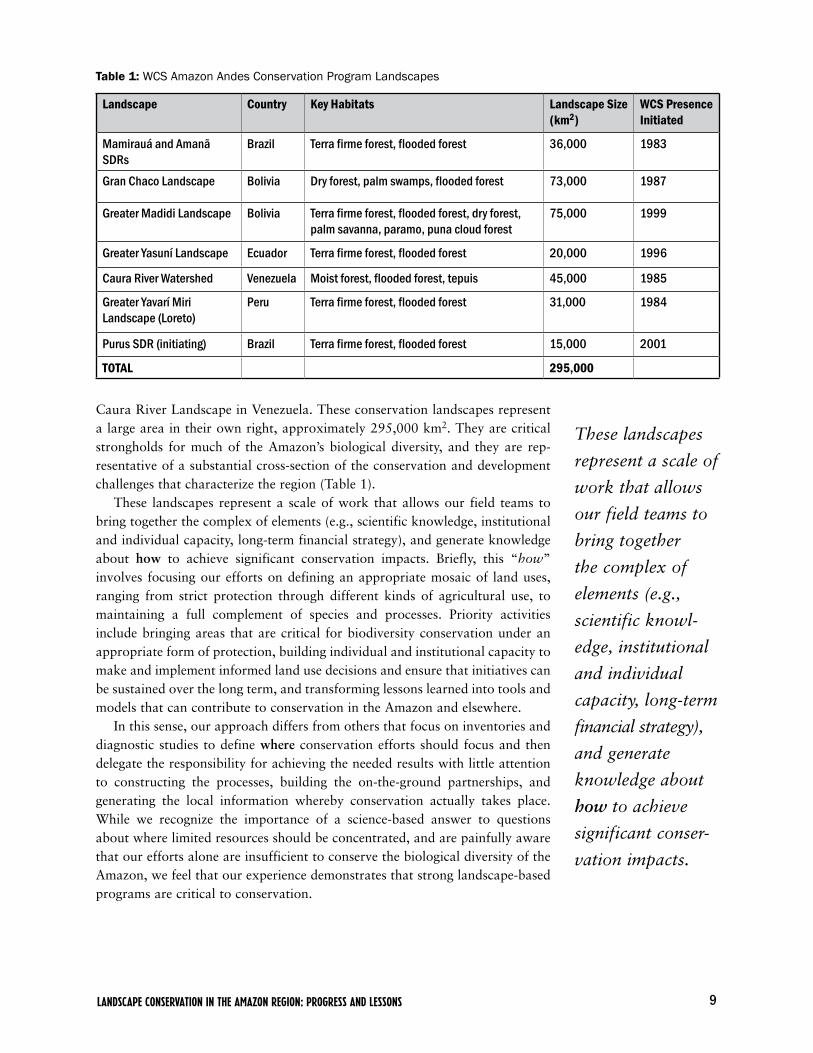
Caura River Landscape in Venezuela. These conservation landscapes represent a large area in their own right, approximately 295,000 km2. They are critical strongholds for much of the Amazon’s biological diversity, and they are rep-resentative of a substantial cross-section of the conservation and development challenges that characterize the region (Table 1).
These landscapes represent a scale of work that allows our field teams to bring together the complex of elements (e.g., scientific knowledge, institutional and individual capacity, long-term financial strategy), and generate knowledge about how to achieve significant conservation impacts. Briefly, this “how” involves focusing our efforts on defining an appropriate mosaic of land uses, ranging from strict protection through different kinds of agricultural use, to maintaining a full complement of species and processes. Priority activities include bringing areas that are critical for biodiversity conservation under an appropriate form of protection, building individual and institutional capacity to make and implement informed land use decisions and ensure that initiatives can be sustained over the long term, and transforming lessons learned into tools and models that can contribute to conservation in the Amazon and elsewhere.
In this sense, our approach differs from others that focus on inventories and diagnostic studies to define where conservation efforts should focus and then delegate the responsibility for achieving the needed results with little attention to constructing the processes, building the on-the-ground partnerships, and generating the local information whereby conservation actually takes place. While we recognize the importance of a science-based answer to questions about where limited resources should be concentrated, and are painfully aware that our efforts alone are insufficient to conserve the biological diversity of the Amazon, we feel that our experience demonstrates that strong landscape-based programs are critical to conservation.
Table 1: WCS Amazon Andes Conservation Program Landscapes
Landscape Country Key Habitats Landscape Size (km2)
WCS PresenceInitiated
Mamirauá and Amanã SDRs
Brazil Terra firme forest, flooded forest 36,000 1983
Gran Chaco Landscape Bolivia Dry forest, palm swamps, flooded forest 73,000 1987
Greater Madidi Landscape Bolivia Terra firme forest, flooded forest, dry forest, palm savanna, paramo, puna cloud forest
75,000 1999
Greater Yasuní Landscape Ecuador Terra firme forest, flooded forest 20,000 1996
Caura River Watershed Venezuela Moist forest, flooded forest, tepuis 45,000 1985
Greater Yavarí Miri Landscape (Loreto)
Peru Terra firme forest, flooded forest 31,000 1984
Purus SDR (initiating) Brazil Terra firme forest, flooded forest 15,000 2001
TOTAL 295,000
These landscapes
represent a scale of
work that allows
our field teams to
bring together
the complex of
elements (e.g.,
scientific knowl-
edge, institutional
and individual
capacity, long-term
financial strategy),
and generate
knowledge about
how to achieve
significant conser-
vation impacts.

10 Wildlife Conservation Society | WORKING PAPER NO. 34
11LANDSCAPE CONSERVATION IN THE AMAZON REGION: PROGRESS AND LESSONS
2. PROGRAM ORGANIZATION AND STRUCTURE

12 Wildlife Conservation Society | WORKING PAPER NO. 34
The WCS Amazon Andes Conservation Program is composed of two major elements: direct support to the seven landscapes aforementioned, and sup-port for activities across multiple landscapes. The landscapes function within the management structures of their individual country programs. This reflects WCS’s desire to keep decision-making as close as possible to the landscapes where actual conservation work is taking place. At the same time, the pro-gram provides cross-cutting support so that the landscapes can learn from one another, and helps build a shared strategic vision of major conservation issues and approaches for addressing them that spans the entire program.
2.1. Landscape-based ProgramsThe seven program landscapes aforementioned are located in areas of the Amazon that are important in their own right because of a combination of richness in biodiversity and unique and important ecosystems (Figure 1). Taken together they represent an important portion of the Amazon Basin that contin-ues to be in a good state of conservation. Yet the challenges to conservation in these landscapes are characteristic of the challenges facing much broader areas of the region. Thus, they represent important on-the-ground experiences of how conservation gets done, and offer lessons that can contribute to conservation at the regional level.
2.1.1. The Mamirauá and Amanã Sustainable Development Reserves (Brazil)
Background
The Mamirauá and Amanã Sustainable Development Reserves are located 70 km northwest of the city of Tefé, in the western part of the Central Amazon region (Figure 2). The Mamirauá reserve covers an area of 1,124,000 ha of várzea flooded forest between the Japurá and Solimões Rivers and Auti-Parană channel, and it is the largest reserve fully dedicated to the conservation of this ecosystem. All of this reserve is constituted by várzea forest and approximately 90% of the area is covered by forest. The várzea forest is the most endangered ecosystem in Amazonia (Goulding et al. 1996). It occurs along the floodplain of the main white-water (alluvial) rivers of the Amazon and is characterized by annual flooding to depths greater than 10 m (Junk 1993). This is an extremely important ecosystem for the survival of many species of birds, reptiles, fish, mammals, and several plants while at the same time it is the most densely human populated environments in Amazonia state, because they are situated at the margin of large rivers, have highly rich nutrient soils and very high fish densities (Ayres 1995).
This is an area important for the population of several endangered and very important wildlife species such as: black caiman (Melanosuchus niger), specta-cled caiman (Caiman crocodilus), the largest reptile on the world: the anaconda snake (Eunectes murinus), several large fish species like the pacu (Metynnis and Mylossoma), tambaqui (Colossoma macropomum), and the pirarucú (Arapaima gigas). Six hundred and thirty-three species of birds have been recorded for the area. The mammal fauna is relatively poor due to seasonal flooding; however,
The várzea
forest is the
most endangered
ecosystem in
Amazonia.

13LANDSCAPE CONSERVATION IN THE AMAZON REGION: PROGRESS AND LESSONS
the area includes two endangered species of primates: the white uakari monkey (Cacajao calvus calvus) and blackish squirrel monkeys (Saimiri vanzolinii). It also contains monk sakis (Pithecia albicans), endangered black-chinned emper-or tamarins (Saguinus imperator), tamarin monkey (Saguinus mystax), night monkey (Aotus nancymaae), and titi monkey (Callicebus dubius), all of which also have a restricted distribution. Other important wildlife species present on the region include the jaguar (Panthera onca), the world largest rodent: capy-bara (Hydrochaeris hydrochaeris), white-lipped peccary (Tayassu pecari), and collared peccary (Pecari tajacu) among others. Aquatic mammals include the two fresh water dolphin species, pink dolphin (Inia geoffrensis), grey dolphins (Sotalia fluviatilis), and manatees (Trichechus inunguis).
WCS and the Instituto de Desenvolvimento Sustentável Mamirauá (Mamirauá Sustainable Development Institute, or IDSM) began collaborating in 1983 on developing and implementing a conservation approach based on the combina-tion of a strong knowledge-based scientific methodology, and local participa-tion in generating and applying scientific information. At the time, the approach was regarded, at best, as a novelty, and, at worst, as a “selling out” of bio-diversity conservation to interests concerned only with the welfare of human populations. In 1990 this collaboration began the process that would lead to the creation of Mamirauá and Amanã as the two first Sustainable Development Reserves (SDRs) in Brazil. Today, the two SDRs are administered by the Sociedade Civil Mamirauá (Mamirauá Civil Society), which receives techni-cal and financial support from the Instituto de Desenvolvimento Sustentável Mamirauá (Mamirauá Sustainable Development Institute, or IDSM), under an agreement with the Amazonas State Government.
Initial activities were concentrated in the focal area of the Mamirauá SDR, which covers about one sixth of the total area of the reserve. It was on the basis of the work there that the natural resource management activities men-tioned above were developed, and the innovative approaches to monitoring were tested, providing the basis for the Mamirauá SDR’s management plan. In recent years, work has focused on the subsidiary areas of the Mamirauá SDR and on the neighboring Amanã SDR, which was created by the Amazonas State Government in 1997. Lessons learned in the core area have been applied and adapted to the different ecological and socioeconomic conditions that charac-terize these two areas.
The importance of these programs was increased by Mamirauá SDR’s inno-vative monitoring program, which demonstrated that incremental improve-ments in management could impact species such as pirarucú (Arapaima gigas), and how sustainable utilization could improve rural livelihoods in Mamirauá’s highly productive flooded forest ecosystems. This combination of successful resource management programs and well documented impacts on wildlife status and human livelihoods helped convince the Amazonas State Government to rep-licate the Sustainable Development Reserve model in other areas of the state.
Program activities currently focus on working with local people and gather-ing the information to prepare the management plan for Amanã SDR. Amanã Reserve (an IUCN category VI protected area) presents an excellent state of conservation. This is because the human population inside Amanã is relatively
At the time, the
approach was
regarded, at best,
as a novelty, and,
at worst, as a
“selling out”
of biodiversity
conservation to
interests concerned
only with the
welfare of human
populations.
14 Wildlife Conservation Society | WORKING PAPER NO. 34
small and concentrated in two areas of the SDR. One population center consists of about 120 families located on the boundary between the Amanã SDR and Jaú National Park. The other group is located on the banks of Amanã Lake, and consists of about 29 villages, grouped in four sectors. As a result, the distur-bance levels are very low, and environmental integrity levels are very high. The rest of the local population is grouped in villages located outside the borders of the Amanã, but meet most of their resource needs from activities carried out inside the area, and thus need to be included in all planning related to resource use in the SDR.
Replication of good practices and processes developed in the focal area of Mamirauá Reserve in the subsidiary areas of Mamirauá and Amanã Reserves is the main goal-and biggest challenge, of this project. To meet this challenge, the program is focusing on applied research to help support the management of economically important local species, and building local capacity to manage fauna and natural resources as well as to undertake the technical and admin-istrative challenges of managing the Mamirauá and Amanã SDRs. Through sound information and demonstrated success in local management, the two SDRs could become key elements in a regional development strategy. For this to happen, the involvement and participation of state and federal government in the design, approval and implementation of local resource management strate-gies are essential.
Major Accomplishments to Date
During the past three years, efforts have concentrated on applying lessons learned and methodologies and tools developed in the Mamirauá SDR to complete a management plan and construct the basic conditions to allow Amanã SDR to function as a protected area. The activities have included scientific research, establishing basic monitoring and law enforcement capacity, and establishing pilot resource management programs, which are described briefly below.
Scientific research. Research activities have been oriented toward collecting information needed to prepare a management plan, which will be presented to the Amazonas State Government for approval. The research has included population and ecology studies of key species of mammals, birds, fish, reptiles, and amphibians, and studies of wildlife movement, focusing on manatees, pec-caries, and aquatic birds. For example, in the 1990s, WCS supported a great deal of basic research and population monitoring of caiman in the Mamirauá Sustainable Development Reserve. Largely as a result of this work, in June 2007 Brazil was able to downlist its population of black caiman on CITES. This was seen as a significant accomplishment and an international recognition of the successful recovery of the species, while at the same time it opens the potential for managed commercial trade from Brazil. Over the last three years the Government of Amazonas State has been actively pushing for commercial management of caiman. Trial experimental hunts have been carried out in the Mamirauá SDR with the idea that these will serve as models for the develop-ment of similar programs in other parts of the state. However, proposals for commercial hunting must be built upon adequate information on the local
Replication of
good practices and
processes devel-
oped in the focal
area of Mamirauá
Reserve in the
subsidiary areas
of Mamirauá and
Amanã Reserves is
the main goal-and
biggest challenge,
of this project.

15LANDSCAPE CONSERVATION IN THE AMAZON REGION: PROGRESS AND LESSONS
populations of caiman, and a robust plan for linking economic benefits to the conservation of caiman and wetlands habitat.
The research component has also included studies of human activities, including traditional patterns of natural resource use, such us hunting, fish-ing, farming, and the exploitation of forest products. The team has looked at demographic trends, and the educational and health status of local populations. These studies help describe patterns of resource use and their implications for wildlife. They also help us to understand issues that need to be addressed if managing the SDR is to result in improvements in the quality of people’s lives, so that they become advocates for the Reserve and the approach to development it represents.
Both kinds of studies have been geo-referenced so that the information gath-ered is linked spatially to political boundaries, bodies of water, forest types, and the expansion of cattle ranching and associated pasture creation.
Basic monitoring and law enforcement. All of Amanã SDR, with the exception of the far eastern part of the reserve along the Unini River and the border with Jaú National Park now has at least basic surveillance and law enforcement. The eastern area of the SDR is not presently covered by the system, but will be incorporated in the coming years. It was initially assigned a lower priority because human population is limited to two small villages and a single isolated household.1 The surveillance system draws on the lessons learned from plan-ning and implementing a similar system for the Mamirauá SDR. During 2007 the surveillance system of Amanã Reserve was able to cover all areas with recorded or significant human activity on the Reserve (550,000 ha), although it represents less than 30% of the entire area (2,350,000 ha). The only exceptions were the two isolated villages mentioned above that are believed to have low impact on the area.
Pilot natural resource management programs. Two years ago, the program initi-ated pilot fisheries management programs focusing on pirarucú and some forest products (timber and non-timber forest products, primarily for small-scale craft activities), as well as promotion of sustainable, stable agricultural production. The program has also undertaken studies to provide basic information to sup-port additional projects dealing with ornamental fish, epiphytes, and ecotour-ism. The pilot activities serve a dual purpose. They generate information that helps support the proposals for productive activities that form part of the man-agement plan. At the same time, they begin to provide new livelihood oppor-tunities for local residents and a context for building organizational skills that will permit local people to undertake more complex activities in the future, and make them better able to mobilize effectively as a constituency for the SDR.
Major Conservation Issues
The conservation of biodiversity in the Amanã SDR still requires the consolida-tion that only a formal, legal situation can offer. The new Brazilian legislation regarding the national system of protected areas brings new requirements that an SDR must meet to qualify for the needed level of protection. They include
1 The human population in the eastern portion of the SDR is just over 700 people, distributed among two communi-ties and a single isolated household. Thus, popula-tion densities in the area are about 0.006 people per hectare. Therefore, surveillance efforts were concentrated on the area adjacent to Amanã Lake, where human settlement is higher.

16 Wildlife Conservation Society | WORKING PAPER NO. 34
the establishment of a participatory management council, the legalization of the locally adopted land use system, and the publication and enforcement of the management plan. Implementation of the surveillance system and consolidation of a communications system linking the Amanã research stations with local authorities are essential for the SDR to achieve a minimal level of functionality. To achieve this, a first step was taken in February 2007, when leaders from the Sectors Amanã, Coraci, São José and from areas of Japurá River and Maraã Municipality participated in one of the regular meetings of the Management Council of Mamirauá Reserve, the neighboring protected area. The idea was to experience first hand in how this council can work, and how community participation in protected areas management can be expressed using the council as a forum. By the end of 2007, all 33 communities were contacted, and meet-ings were held in all villages to discuss the establishment of the Management Council. The first training course for potential candidates to be representatives of local communities in the future deliberative council was held in May 2007. The composition of the seats in the Management Council of Amanã Reserve, and the election of the first members will be carried out in 2008.
Along the same lines, in the communities, a new set of environmental educa-tion activities are being carried out aiming to improve environmental awareness and community empowerment. These activities are mainly the creation of com-munity radio broadcasting (actually, systems of loud-speakers and amplifiers on strategic communities) followed by training community members to broadcasts news on community issues. Training courses for local teachers was one of the most important activities in 2007, covering 11 villages (circa 30% of the total) of Amanã Reserve. Teachers of other schools (from the neighboring towns and from Mamirauá Reserve) also attended and benefited from these courses. Workshops with children from the reserve were aimed to raise awareness about local environmental issues. Important meetings with fishermen and manatee hunters from Amanã achieved to convene relevant members of the communities and involve them in the discussion of these issues. Finally, a field center for the recovery and rehabilitation of juvenile manatees was created in Amanã reserve in 2007, and it is used as a powerful tool for environmental education.
Although parts of Amanã SDR can currently benefit from the establish-ment of some programs of sustainable management of natural resources, other important natural resources are still used in more traditional ways, and some remote parts of Amanã are in need of the implementation of such programs. Public awareness about the SDR and general recognition of the authority and responsibility exercised by the local population are crucial for the success of such programs. Only then will the local public policies and practices of local economic agents consider new sustainable production options, in collaboration with local inhabitants.
Programs and projects run at Amanã SDR are vulnerable to changes in the availability of financial resources. This is especially relevant for those programs related to the basic functioning of the protected area. To face this situation, a long term strategy for fund-raising and financial management and a contingen-cy plan for periods when finances are tight are needed. To address this, the pro-gram has recently completed a business plan, with support from WCS’s Amazon Andes Conservation Program’s (AACP) conservation finance component.
Public awareness
about the SDR
and general
recognition of
the authority and
responsibility
exercised by the
local population
are crucial for the
success of such
programs.

17LANDSCAPE CONSERVATION IN THE AMAZON REGION: PROGRESS AND LESSONS
2.1.2. The Piagaçu-Purus Sustainable Development Reserve (Brazil)
Background
Indigenous peoples are, to this day, the main inhabitants of rural areas in the Brazilian Amazon. Nonetheless, until 1999 traditional populations were not allowed to remain inside declared federal protected areas. This changed with the establishment of a new system of conservation units, which had to overcome the challenge of reconciling the conservation of natural resources with the needs of local communities to use such resources.
The Purus River of Andean origin is a tributary of the Solimões-Amazonas River system and encompasses approximately 21,000 km2 of várzea (forest that are seasonally flooded by white water). It is a meandering river, forming several lakes that remain connected throughout the wet season. Non-flooded, terra firme habitats delimited by narrow channels of water (igarapés) are also common. This area is of great environmental importance due to its biological diversity and morphological complexity. It is also an important source of fish for the city of Manaus. This area is home to 60,000 people distributed along the margins of the Purus River.
The first expedition to Piagaçu-Purus took place in 2001 with support from WCS. This expedition provided the scientific information required to propose the area as an SDR, culminating in the creation of the Piagaçu-Purus SDR by the Amazonas State Government in August 2003 (Figure 3). The reserve covers approximately one million hectares of both várzea and terra firme forest. It is connected to the 28,800 ha Abufari Biological Reserve, and also encompasses four indigenous lands totaling 3,200 ha. Together these lands preserve a con-tinuous corridor of Amazon rainforest in Brazil.
This area’s biodiversity is very similar to that of Mamirauá and Amanã Sustainable Development Reserves as the várzea forests cover most of the region. This forest is the most endangered ecosystem in Amazonia (Goulding et al. 1996) because is an extremely important ecosystem for the survival of many species of birds, reptiles, fish, mammals, and several plants while at the same time it is one of the most densely human populated environments in the state of Amazonas, due to its strategic position along the margins of large rivers, which have highly rich nutrient soils and very high fish densities (Ayres 1995).
WCS’s participatory approach, bringing together local people’s traditional practices and state of the art scientific knowledge, has been used as a model for the work developed in the area. Many experiences acquired in other regions have been replicated at the reserve, contributing effectively to the successful conservation of Piagaçu-Purus’s natural resources.
Activities conducted at Piagaçu-Purus SDR have focused on surveys of the current status of the biodiversity as well as socioeconomic conditions of local communities, and also on the assessment of the anthropogenic impact from the exploitation of natural resources. For example, a group of caiman hunters from communities in three different reserves (four of them from Piagaçu-Purus SDR) received training as monitors and census surveyors of Melanosuchus niger and Caiman crocodylus nesting areas. At the same time, the SDR’s growing economic importance as the source of 45-60% of the fish sold in the Manaus market, will offer valuable lessons for sustainable fisheries management. Initial
Indigenous
peoples are, to
this day, the main
inhabitants of
rural areas in the
Brazilian Amazon.
Nonetheless, until
1999 traditional
populations were
not allowed to
remain inside
declared federal
protected areas.

18 Wildlife Conservation Society | WORKING PAPER NO. 34
steps necessary to conduct these activities included the establishment of head-quarters in Manaus, the acquisition of basic materials and equipment needed to conduct field work, and assembling a team of researchers to work in the reserve. Training and capacity building of researchers involved in the project was provided through Geographic Information System (GIS) courses, as well as through exercises conducted to develop a conceptual model of conservation objectives and activities at the reserve, sponsored as cross-cutting activities by the WCS Amazon Andes Conservation Program.
Major Accomplishments to Date
Since the beginning of this program in 2001 efforts have focused on gathering basic biological and socio-economic information to support a management plan; helping local communities get organized through associations and/or coopera-tives; promoting the use of techniques that allow the sustainable exploitation of natural resources; and proposing the establishment of areas of sustainable use and areas of integral protection within the SDR.
During this initial period, the Instituto Piagaçu (Piagaçu Institute, or IP) was legally established as a non-profit, non-governmental organization (NGO) to provide technical and financial support to the Piagaçu-Purus SDR, and was recognized by the Amazonas State Government as the entity responsible for gathering information and elaborating on the SDR’s management plan. Within the SDR, initial work has focused on a core area, which includes the three main forest habitat types found there: non-flooded (terra firme) forests, forests that are flooded seasonally by white water (várzea), and forests that are more or less permanently flooded by black water rivers (igapó). The project has also undertaken discussions with indigenous organizations living on the edges of the Piagaçu-Purus SDR to allow resource management activities to be conducted on indigenous territorial lands in order to construct a more integrated approach to landscape management that generates more livelihood options for indigenous people.
Beyond establishing the legal and institutional context of the program’s efforts in the Piagaçu-Purus SDR, the collection and assembly of the biological, ecological, and socio-economic information required to complete a manage-ment plan (to be presented to the Amazonas State Government for review and approval), has yielded valuable indirect results. These include the identification and assessment of land-use conflicts that need to be addressed. In addition, ini-tial studies have identified 14 primate species in the SDR including two endan-gered primates inhabit this region, the white uakari monkeys (Cacajao calvus calvus) and blackish squirrel monkeys (Saimiri vanzolinii), which make it one of the most diverse areas for primate species in the Neotropics. For fish species, we completed an ichthyological survey in October 2007 for Piagaçu-Purus SDR with 298 fish species currently recorded for the area, representatives of igarapés (streams), rivers, lakes in environments of alluvial (várzea) and non-alluvial (igapó) seasonally flooded forest, and terra firme. The analysis also revealed the existence of a unique environment located on the Jari sector, in the form of a brackish lake.
19LANDSCAPE CONSERVATION IN THE AMAZON REGION: PROGRESS AND LESSONS
Regarding wildlife hunting we have conducted population surveys of birds and terrestrial mammals in Ayapuá and Uauaçu sectors of the Reserve with 20 species recorded as being used for hunters. A participatory mapping exercise covering hunting areas was also conducted with Jarí residents.
Major Conservation Issues
The Purus region contributes to the biodiversity of the Amazon rainforest through a complex, heterogeneous environment and large intact habitats (várzea and terra firme) exploited by birds, mammals, fish, amphibians, and reptiles. Avifauna diversity is extraordinary with over six hundred and thirty species. The largest snake in the world, the great anaconda (Eunectes murinus) is found here, as well as two species of caiman, the black caiman (Melanosuchus niger), and the spectacled caiman (Caiman crocodilus). Much of the landscape is affected by human presence, because of the waterways used for transportation. Terrestrial mammal diversity is smaller because the habitat is often flooded. However, the area also is home to the jaguar (Panthera onca), tapir (Tapirus ter-restris), white-lipped peccary (Tayassu pecari), capybara (Hydrochaeris hydro-chaeris), several monkey species as well as two fresh water dolphin species, pink dolphin (Inia geoffrensis), grey dolphins (Sotalia fluviatilis) and manatees (Trichechus inunguis). Very large fish live in these whitewater rivers, and dur-ing the rainy season they roam through the flooded forest eating fruits from the floodplain trees and dispersing the seeds. These fish include the pacu (Metynnis and Mylossoma), tambaqui (Colossoma macropomum), pirarucú (Arapaima gigas), sardinha (Triportheus angulatus), and the smaller carnivorous characin, the piranha (Serrasalmus spp.). Many beautiful aquarium fish come from these rivers and blackwater tributaries and lakes in this region.
The Piagaçu-Purus SDR has connectivity with indigenous lands and with the Abufari Biological Reserve, forming a mosaic that effectively functions as an ecological corridor in the Amazon. Human expansion poses one of the main conservation issues throughout the Brazilian Amazon. One recommen-dation aimed at controlling this expansion is to take into account traditional populations that are already there and encourages the sustainable use of natural resources. This requires the promotion of production practices based on the sustainable use of renewable resources.
The BR 319 highway, located in the interfluvial zone between the Purus and Madeira Rivers, connects Porto Velho, in the State of Rondônia, to Manaus. The Brazilian federal government is now proposing to pave this road, which will not only reduce the isolation of the communities that inhabit the area, but may also facilitate the access of speculators and others interested in taking possession of nearby lands without regard to environmental regulations, or otherwise. Due to the proximity of the Piagaçu-Purus SDR, the BR 319 Federal Road Pavement Project poses a threat, if the commonly observed pattern of human expansion along the main road is not controlled. Currently the Brazilian Institute of Environment and Natural Resources (IBAMA), the governmental agency responsible for the protection of natural resources, is preparing an environmental impact assessment report for this project, which will include rec-ommendations to ensure that this fish-bone pattern of human settlement along

20 Wildlife Conservation Society | WORKING PAPER NO. 34
roads branching off from the main highway does not take place. The creation of new protected areas in the Madeira-Purus interfluvial zone would be a vital strategy to help guarantee the protection of the rich biodiversity of the Piagaçu-Purus SDR. The federal government is concerned that the SDR and surround-ing area not placed at risk by the construction of the highway. To this end, it has created a temporary protected area (Area with Provisional Administrative Limitations on Use, ALAP) with the intention of halting forest cutting associ-ated with the highway.
The Amazonas state government is also interested in promoting and strength-ening economically sustainable activities based on products from the Amazon forest. The aim is to generate employment opportunities that will increase the income and improve the quality of life for traditional communities. The dis-semination of techniques for production and processing, as well as support for the establishment of business enterprises, would be based on the development of environmentally sound and economically viable activities. However, to assess the economic potential for the exploitation of specific natural resources it is first necessary to learn more about the traditional economic activities of local communities, as well as to identify other resources that may have economic potential and hence may be proposed as additional alternatives. Nonetheless the sustainable model applied in the Brazilian Amazon has enormous potential to succeed, and can be used as an model for the effective conservation of natural resources in several areas of the greater Amazon region.
2.1.3. Greater Yasuní-Napo Landscape (Ecuador)
Background
The Greater Yasuní-Napo Landscape and Yasuní National Park (YNP) in northeastern Ecuador protect the core of one of the richest biodiversity hotspots on the planet and one of the last tracts of pristine, continuous tropical forests in eastern Ecuador. This tropical moist forest system is one of the world’s biodi-versity hotspots, containing some 4,000 species of plants, at least 70 species of mammals, among them 13 species of primates. This is one of the richest sites for primate diversity on Earth, including woolly monkeys (Lagothrix lagotricha), red howlers (Alouatta seniculus), spider monkey (Ateles belzebuth), and monk saki (Pithecia monachus). Other non-primate mammals are lowland tapirs (Tapirus terrestris), white-lipped peccary (Tayassu pecari), jaguar (Panthera onca), the two Amazon freshwater dolphin species, giant river otter (Ptenoura brasiliensis). There are more than 600 species of birds including the hoatzin (Opisthocomus hoazin), the Salvin’s curassow (Mitu salvani), scarlet macaw (Ara macao), and the blue and yellow macaw (Ara ararauna). Reptiles include the anaconda, black caiman, and spectacled caiman. Rivers turtles (Podocnemis unifilis) are also very important, as human communities depend heavily upon turtle eggs for subsistence. Fish species include the pirarucú or paiche (Arapaima gigas) and piranhas (Serrasalmus sp).
This region is also home to the Cofán, Kichwa and Waorani indigenous peoples, including two uncontacted Waorani family groups who live in the core of YNP. Because of its exceptional cultural and biological value, the Greater Yasuní-Napo Landscape (Figure 4) was designated as a Biosphere Reserve in

21LANDSCAPE CONSERVATION IN THE AMAZON REGION: PROGRESS AND LESSONS
1989 and has received substantial national and international attention. Despite these efforts, the Greater Yasuní-Napo Landscape is still intensely threatened by poorly regulated oil industry activities, illegal timber extraction, the accultura-tion of indigenous groups, and institutional weakness of some local stakehold-ers involved in the management of the area.
Since 2000, WCS has identified the Greater Yasuní-Napo Landscape as its priority in Ecuador not only because of its exceptional biodiversity, but also because of the urgency of the threats that this area faces. As an attempt to curb the effects of these threats, WCS has focused on monitoring the impacts of human activities on local wildlife, working with local communities to develop management plans for the areas under their jurisdiction, and building the capac-ity of the YNP staff, management committee, and key stakeholders. In the long term, we expect this strategy to result in more effective oversight of the timber and oil industries by local stakeholders, who will be well organized to encour-age the national government to enforce and strengthen environmental laws. We also expect to help local communities to become more effective managers of the natural resources on which they depend by constructing new income options and incorporating concepts of conservation and sustainable use of renewable resources into their land management practices. Our work in these two areas will reinforce improvements to the management of the YNP and contribute to overall effective protection of the landscape and its unique wildlife.
Since its inception, the WCS program in Ecuador has faced three critical obstacles: the political instability in Ecuador during the last five years; the prev-alence of a poorly-regulated oil industry with profound impacts on the ecologi-cal, socioeconomic, and cultural dynamics of the YNP; and the extreme frailty and complexity of the social and institutional fabric of the region. Although these factors have challenged progress, we have achieved important advances in terms of improving the management of community lands of six Kichwa com-munities, developing a strong monitoring system to assess the effects of specific oil industry activities on the wildlife of the Greater Yasuní-Napo Landscape, and developing effective working relationships, which contribute to local stakeholders beginning to define shared interests and develop strategies for working together. Our work on the promotion of open communications among local stakeholders in the management committee has also resulted in better and broader appreciation about the actual and potential importance of YNP to the quality of local livelihoods, the urgency of the threats it is facing, and the implications of the threats for people living in and around the park. These improved communications are being used as the basis for local fora in which actors discuss and share experiences and topics related to the rational manage-ment of the region.
Major Accomplishments to Date
A monitoring system is in place for the continuous assessment of the impacts of oil extraction roads on the medium-sized mammals and amphibians of the Greater Yasuní-Napo Landscape. We have chosen these two groups because the first is highly sensitive to disturbance and hunting by humans, and the second is highly sensitive to ecosystem change. This study showed that several species
The Greater
Yasuní-Napo
Landscape is still
intensely threat-
ened by poorly
regulated oil
industry activi-
ties, illegal timber
extraction, the
acculturation of
indigenous groups,
and institutional
weakness of some
local stakehold-
ers involved in the
management of
the area.

22 Wildlife Conservation Society | WORKING PAPER NO. 34
have been affected by the dual effect of roads and hunting pressure along them. The guanta (Cuniculus paca), white-lipped peccary (Tayassu pecari), spider monkeys (Ateles belzebuth), woolly monkey (Lagothrix poeppigii) and guatuza (Dasyprocta fuliginosa), as well as several curassows species, are the most affected species, showing densities greater in the areas far away from roads (WCS-Ecuador Bulletin No 1). The information generated by this monitoring system is being used to inform the Ministry of the Environment and promote new regulations for oil infrastructure allowed within YNP.
In collaboration with six Kichwa communities in the northern portion of YNP, the landscape conservation program facilitated the development and consolidation of an agreement between these communities and the Ministry of the Environment for the sustainable use of the community lands that overlap with YNP. During this process WCS was directly involved in the analysis and resolution of persistent conflicts over the boundaries of three of these commu-nities, a step that was crucial in terms of advancing towards the signing of the agreement.
Under this agreement, WCS is working with the three communities to develop a communal reserve in the southern border of their territories along the Tipuni River with the double purpose of protecting their lands from colo-nization by outsiders and conserving an un-hunted reserve that could serve as a source area for the hunting grounds of the communities. The location and extent of this reserve was based on the hunting surveys and participatory maps that we developed with each community. These maps determined that almost 90% of the hunting events occurred within the first 7 km to the south of the main settlements along the Napo River; this spatial pattern that leaves the region of the Tiputini as a relatively undisturbed area which, based on our wildlife surveys, serves as a safe haven for wildlife and as a source of animals that are eventually captured in the hunting grounds of the communities.
The program produced a revised and updated map that spatially locates the threats to biodiversity. The revised map has been used by WCS and other stakeholders over the past two years to set priorities and design activities that respond to the distribution, types, and levels of impacts affecting the landscape. The characterization incorporates a temporal analysis of change in forest cover and human settlements. This temporal component provides a dynamic view of the landscape (trends and rates of change) and gives predictive capability to the map, making it a powerful tool for communication, planning and monitoring.
The program also completed an assessment of illegal wildlife trade. Our study shows that the trade of wild meat in this area has tripled during the last two years, and at least 80% of the meat comes from inside the YNP. We docu-mented 56 species that are being traded on a single wildlife market, producing among 13,000 to 14,000 kg of wild meat per year. At the same time, however, the benefit for the local communities is minimal and most of the profit goes to four middlemen who sell the meat at restaurants in local towns as far as 250 km away from the YNP. This information is being compiled in a report to the Ministry of the Environment and the Environmental Police with the aim of designing proper interventions to curtail this activity. Most of the meat came first from the white-lipped peccary (Tayassu pecari), followed by the guanta
In collaboration
with six Kichwa
communities in the
northern portion
of YNP, the land-
scape conservation
program facilitated
the development
and consolidation
of an agreement
between these
communities and
the Ministry of the
Environment for
the sustainable use
of the community
lands that overlap
with YNP.

23LANDSCAPE CONSERVATION IN THE AMAZON REGION: PROGRESS AND LESSONS
(Cuniculu paca), the brocket deer (Mazama americana), and one species of woolly monkey (Lagothrix poeppigii). The latter is on IUCN’s Red List (www.iucnredlist.org). It was also documented that between 8,000 and 10,000 eggs of river turtles are sold every year in one the wildlife markets (WCS-Ecuador Bulletin No 2)
The program also carried out an eight-day training course for local people and professionals titled “New perspectives and tools for field conservation biology” and taught by WCS and other experts in the conservation field. Additionally, Waorani people are being trained in wildlife and hunting monitor-ing along the Maxus Road by a researcher who is conducting jaguar camera trapping research.
The program at the Greater Yasuní-Napo Landscape worked with diverse local stakeholders, including indigenous organizations, municipalities, the Ministry of the Environment, and oil companies, towards the establishment and consolidation of a management committee for the Yasuní Biosphere Reserve (YBR). Although this committee is not fully operational, its administrative and functional structure is in place and the group is already holding periodic meet-ings. The next phase will involve the consolidation of this committee through the implementation of specific projects and activities relevant to the conserva-tion of the YBR. Given the instability of the government and the weakness of the national and local environmental authorities, consolidation of this commit-tee is crucial to ensure effective conservation in the area.
In terms of surveillance activities, we developed: (1) the establishment of a 10 person group from Kichwas communities; (2) support of the construction of three community checking posts; (3) acquisition of radio communication equip-ment; and (4) establishment of a 5 km forest strip where no hunting is allowed to serve as a buffer area for the YNP.
Major Conservation Issues
The Greater Yasuní-Napo Landscape is of critical importance for the con-servation of the unique biota of the upper Amazon Basin. This area harbors biodiversity levels that have rarely been recorded for other ecosystems on Earth, including the highest diversity of trees reported to date. Additionally, the Greater Yasuní-Napo Landscape is a fundamental part of a complex of forests (including the tropical forests of the Sumaco Biosphere Reserve, the Cuyabeno Faunal Reserve, and the vast Peruvian forests to the east) the sheer size of which is large enough to maintain healthy wildlife communities, and a functional con-nection between the upper Amazon Basin and the foothills of the Andes. Finally, the Greater Yasuní-Napo Landscape lies at the foothills of the Andes, providing connectivity to the lower elevations of the Andes with the rest of the Amazon.
Its conservation significance notwithstanding, the Greater Yasuní-Napo Landscape is still facing several threats that, if not controlled in the near future, could endanger the integrity of the area and the long term persistence of its biota. Preeminent among these threats are: (1) illegal logging within the Tagaeri-Taromenane Intangible Area and the lack of protection mechanisms to ensure the survival of uncontacted groups; (2) the uncontrolled colonization and extraction of timber from the western portion of YNP, which could eventually
Its conservation
significance not-
withstanding, the
Greater Yasuní-
Napo Landscape
is still facing sev-
eral threats that,
if not controlled
in the near future,
could endanger
the integrity of the
area and the long
term persistence
of its biota.

24 Wildlife Conservation Society | WORKING PAPER NO. 34
sever the connection between the protected area and the foothills of the Andes; (3) inadequate management of the YNP, particularly in the areas of biologi-cal monitoring and basic surveillance, while management plans for territorial units are not implemented or do not exist; (4) the political weakness and low technical capacity of national park authorities and other critical stakeholders in the area; (5) poorly-regulated oil industry activities; and (6) lack of political organization among the Waorani and lack of experience dealing with western culture that renders them easily manipulated by the oil companies, and makes it difficult to engage in conservation programs and organized activities.
To address some of these threats, WCS will continue to work with the Ministry of the Environment, the local communities, and the management com-mittee of the YBR towards the incorporation of additional lands in conserva-tion schemes, the development of communication and monitoring tools for the informed management of the wildlife in the Greater Yasuní-Napo Landscape, and the strengthening of local stakeholders, especially local communities and park authorities, to ensure that they have the technical capacity and assistance to improve the conservation status of the Greater Yasuní-Napo Landscape. We are also making a strong commitment to Waorani communities and organiza-tions, including the Asociación de Mujeres Waorani del Ecuador (Association of Waorani Women of Ecuador, or AMWE), and the Nacionalidad Waorani del Ecuador (Waorani Nation of Ecuador, or NAWE) to promote their unity and capacity in the defense and management of their territory, strong and continu-ous relations between organization leaders and communities, and the integra-tion of the Waorani into the management of the Yasuní National Park and Yasuní Biosphere Reserve. We also seek the integration of the private sector—the oil companies—into constructive alliances with indigenous organizations and protected areas.
2.1.4. The Greater Yavarí – Yavarí Miri Landscape (Peru)
Background
The lowland Amazonian forests of Loreto, Peru cover an area of 379,450 km2, of which over 80% is still considered intact wild lands. Despite the good con-servation condition of much of Loreto and the biodiversity value of Loreto’s forests along with other areas of the western Amazon, only 13.6% of Loreto is currently within Peru’s System of Natural Areas Protected by the State (Sistema de Áreas Naturales Protegidas por el Estado, or SINANPE). This is largely made up of the Pacaya-Samiria National Reserve, a large flooded forest habitat. The upland terra firme habitats that make up the majority of Loreto are not propor-tionally protected under the national system.
The long-term vision of WCS in the Yavarí Valley has been to consolidate biodiversity conservation over the landscape using a combination of protected areas characterized by high levels of local involvement in management and strategies based on wildlife conservation. Over the years WCS has been working with a number of conservation groups, universities, and government agencies to implement a strategy for wildlife conservation that will result in landscape-level biodiversity conservation of the Greater Yavarí (Figure 5).
The long-term
vision of WCS in
the Yavarí Valley
has been to con-
solidate biodiver-
sity conservation
over the landscape
using a combina-
tion of protected
areas characterized
by high levels of
local involvement
in management
and strategies
based on wildlife
conservation.

25LANDSCAPE CONSERVATION IN THE AMAZON REGION: PROGRESS AND LESSONS
The long-term goal is to have a matrix of land use in the Yavarí Landscape that includes areas where wildlife is hunted sustainably, where community-based source areas (fully protected areas that rural communities implement), are adjacent to use areas, and where national level protected areas work with the rural people, not against them. WCS has been implementing these goals by taking three foci: (1) conservation action, (2) promoting conservation, and (3) conservation-oriented research.
The focus on conservation action has included activities that directly impact wildlife conservation in the landscape. This includes setting up community-based wildlife management programs, helping to develop new protected areas, helping to manage existing protected areas, and starting a process to implement peccary pelt certification as a catalyst for community-based conservation. The WCS project in the Yavarí Landscape has also actively been involved with pro-moting conservation through field-based courses, publications in Spanish for distribution in Loreto and throughout Latin America, by organizing workshops, the Latin American wildlife conferences, and running a web-based journal on wildlife conservation in Latin America. Conserving wildlife requires conserva-tion oriented research, and field research has been an important focus of the WCS projects in the Greater Yavarí Landscape. Research projects have focused on how to set up successful community-based wildlife management programs, how to help set up and manage protected areas, and how to help set up a pec-cary pelt certification program.
Major Accomplishments to Date
The project worked towards conserving biodiversity in the Greater Yavarí Landscape through promoting protected areas, conducting research, imple-menting sustainable wildlife use, assisting with community-based conserva-tion, and capacity building. This has included working with local people to design and manage advanced community-based wildlife management in the Tamshiyacu-Tahuayo Regional Conservation Area (Área de Conservación Regional Tamshiyacu-Tahuayo or ACRTT), the Yavarí Miri River, and the headwaters of the Yavarí River, using a combination of participatory research and extension activities.
The project in the Yavarí Landscape participated in developing a proposal for the creation of a protected area in the Greater Yavarí, supported efforts to incorporate the ACRTT into the regional protected area system, and established and managed the conservation concession at Lago Preto on the Yavarí. Together these three areas comprise over one million hectares of western Amazonian forest.
Wildlife surveys were conducted along the Yavarí-Miri River to determine the impact of hunting by loggers. The results of the survey showed that the wild-life populations of the Yavarí-Miri are still generally healthy and that hunting by loggers has not yet reduced the numbers of large game species. The survey focused on four game species, the collared peccary (Tayassu tajacu), the white-lipped peccary (Tayassu pecari), the lowland tapir (Tapirus terrestris), red-brocket deer (Mazama americana), and woolly monkey (Lagothrix poeppigii).
The long-term goal
is to have a matrix
of land use in the
Yavarí Landscape
that includes areas
where wildlife
is hunted sus-
tainably, where
community-based
source areas (fully
protected areas
that rural commu-
nities implement),
are adjacent to use
areas, and where
national level
protected areas
work with the
rural people, not
against them.

26 Wildlife Conservation Society | WORKING PAPER NO. 34
A summary of results: The collared peccary population has been increasing in the area over the past ten years, their populations remain stable at around 9 ind./km2. The white-lipped peccary population decreased substantially in 2002 prior to the arrival of the loggers, apparently after exceeding the carrying capacity of the environment that causes a crash of the population when density surpassed 16 ind./km2. Currently the population is estimated around 5 ind./km2 with a slight but non-significant increase in the last few years. The lowland tapir population has been decreasing over the last 12 years. The current den-sity at Yavarí-Miri is lower than 0.1 ind/km2, which is similar to other hunted areas in lower Peru. The population of brocket deer has always been low in the Yavarí-Miri region and is currently around 1 ind/km2, which is similar to other regions of the Peruvian Amazon. Woolly monkeys are doing very well in the area despite their vulnerability to hunting pressure. Current density estimates are over 30 ind./km2, which is one of the highest densities ever reported for this species.
The project has also explored ways to have a broader influence on wild-life conservation throughout the entire region of Loreto, through its peccary pelt certification program and promoting wildlife management in the newly created forestry concessions. At the national level, the project has designed a peccary pelt certification program to promote sustainable wildlife management throughout the region, and this has been approved by the National Natural Resources Institute (INRENA), which will include the program in the national forestry and wildlife regulations. At a local level nine communities have agreed to participate in the pilot program and have begun to implement community-based wildlife management to achieve certification. At INRENA’s request, WCS has submitted recommendations for establishing the peccary pelt quota for Loreto. The project also worked with INRENA to set up guidelines for wildlife management in forestry concessions. The project worked with a set of forestry concessions in the Yavarí Miri that have voluntarily agreed to participate in a feasibility study.
The peccary pelt program is based in the fact that both species, the collared peccary (Tayassu tajacu), and the white-lipped peccary (Tayassu pecari) are important resources for subsistence hunters in the Peruvian Amazon, as else-where in the Amazon Basin (Bodmer et al. 2004a). In Peru, subsistence hunting of peccaries is permitted and is legally defined as the use of peccary meat for household consumption or the sale of peccary meat in settlements of fewer than 3,000 inhabitants. Rural inhabitants hunt peccaries mainly for their meat, which has an economic value of approximately $23 for a Collared peccary and $30 for a white-lipped peccary either for subsistence food or sale (Bodmer et al. 2004b). Peccary pelts are sold as a by-product and have an economic value to hunters of approximately $5 for a Collared peccary pelt and $3 for a White-lipped peccary pelt (Bodmer and Pezo 2001, Fang 2003). The only country with CITES permit to export white-lipped peccary pelts for the hide trade is Peru where a quota of between 35,500 and 44,300 skins and leather products has been granted annually since 1997(CITES, Database-2008; www.cites.org). The pelts are tanned in Peru and sold to the European leather industry for the manufacture of high quality shoes and gloves, with the latter retailing for as much as $200 a pair.
The project has
designed a peccary
pelt certification
program to pro-
mote sustainable
wildlife manage-
ment throughout
the region, and
this has been
approved by the
National Natural
Resources Institute
(INRENA), which
will include the
program in the
national forestry
and wildlife
regulations.
27LANDSCAPE CONSERVATION IN THE AMAZON REGION: PROGRESS AND LESSONS
Field-based courses organized by the project involved Peruvian university students at BSc and MSc level, professionals from NGOs and government agen-cies, and university students from other Latin American countries and from the Durrell Institute of Conservation and Ecology (DICE). Courses were integrated with local community involvement and demonstrated the need for community-based conservation and wildlife research.
One of the major outcomes of the Cross Cutting Workshop on Wildlife Management held in April 2007 was the need to determine ways of estimating the size of source areas for wildlife. Source areas are a key aspect of the cross cutting program, since they can be used to increase the number of hectares under protection using a wildlife management strategy. Source-sink areas can provide a buffer against the biological and socio-economic uncertainty of bush meat hunting. Source areas are non-hunted areas adjacent to hunted (sink) areas. Wildlife emigrates out of source areas and immigrates into sink areas, if sink areas have been overhunted. Indeed, implementing the guidelines incorporates community-based protected areas as an integral part of the process through the use of source areas -the establishment of non-hunting areas adjacent to hunting zones that allow animal populations to flourish in an undisturbed environment. The cross cutting wildlife program has developed a method to estimate the size of source areas using the collared peccary (Tayassu tajacu) as the landscape spe-cies determining the size of areas needed. The results of the analysis showed the following: To determine the size of a source area needed to ensure the sustain-ability of collared peccary hunting, a population viability analysis (PVA) was used to determine the population size required to support the current level of harvest with zero probability of extinction (PE). For the baseline PVA model, the stochastic population growth rate is 0.054 ± 0.138 SD with zero probability of extinction (PE) in 50 years, and a mean population size of 4790, having set carrying capacity equal to the initial population size of 7000. The minimum population size with zero PE in 50 years is 3250 with a population growth rate of 0.042 ± 0.162 SD and a mean population size in 50 years of 4621 individu-als. The PVA analysis also showed that sex ratio at birth is one of the variables that affect the most the growth rate of the population.
The project also co-hosted, with the National University of the Peruvian Amazon (Universidad Nacional de la Amazonia Peruana or UNAP) and DICE, the 6th International Conference on Wildlife Management in Amazonia, which was attended by over 600 participants throughout Latin America. The project began a new web-based journal, Manejo de fauna silvestre en Latinoamérica (Wildlife Management in Latin America), which may be accessed online at http://www.revistafauna.com.pe. The journal provides a Spanish language forum for publication of research on wildlife management, and is a tool to maintain communication and collaboration between conservation professionals in the region.
The activities described above have been complemented and supported by a continuing research effort in the Yavarí Valley, focusing on wildlife population ecology studies, research on behavioral ecology, and studies of the sustainability of resource use and the socio-economics of natural resource use by rural com-munities. For example, research on red uakari monkeys, the flagship species of the Lago Preto Conservation Concession, has shown the importance of long-

28 Wildlife Conservation Society | WORKING PAPER NO. 34
term research. Density surveys have been conducted on a regular basis at Lago Preto since 1999, when the red uakari population was estimated at around 14 ind./km2. Since conservation actions have been set up at the Lago Preto conces-sion the red uakari population has increased steadily and dramatically. Censuses conducted in 2006 and 2007 have shown the greatest densities of red uakari at Lago Preto with numbers around 116 ind./km2. The current red uakari popula-tion at the Lago Preto Conservation Concession is estimated at around 2,600 individuals. The rate of increase in the red uakari population appears to be close to the maximum. Indeed, average annual increase of red uakari at Lago Preto spread over all years between 1999 and 2007 is approximately 30%. The absolute maximum rate of increase of the red uakari would be 33%, if all reproductively active females reproduced each year.
Additionally, we started to see some signs of turtle (Podocnemis unifilis) population increase, thanks to the recovery program started eight years prior and consisting of replanting turtle eggs in artificial beaches. Given that eight years are the minimum time for the individuals to growth to maturity, we fore-see a healthy population in the years to come. Finally, due to a close collabora-tion with the Cocha Wiuri management group, the pirarucú (Arapaima gigas) is recovering from years of overexploitation in some of the lakes of the region.
Major Conservation Issues
The Greater Yavarí Landscape holds tremendous potential for successful con-servation, combining high levels of biodiversity and very low human population density (most people living along the major rivers and the interior of the forests being largely devoid of human habitation). However, the long-term conserva-tion of the Greater Yavarí will require a landscape that incorporates multiple protected areas characterized by different organizational structures and man-agement arrangements based on the biophysical and social contexts in which the conservation of the landscape’s forests, lakes, and rivers must take place.
Conservation initiatives must be set up in a manner that reflects the socio-economic and political reality of the region. In the Yavarí Landscape there are many isolated communities with little government presence. Community-based wildlife management has the best chance of success in this context. Local people are truly interested in managing wildlife as a way to secure land use rights and long-term economic benefits from natural resource use. In the Yavarí Valley many animal populations are large enough to support sustainable levels of hunting. But more importantly, these community-based programs allow people to set up unhunted, fully protected source areas that fit well with both sustain-able use and protected area strategies.
The newly created forestry concessions along the northern side of the Yavarí Miri River are a major source of concern. The Peruvian Government has imple-mented a long-term forestry concession policy as one of its sustainable devel-opment initiatives. The idea is that 40-year concessions will be managed more appropriately than 5-year licenses, since concession owners will have a long-term commitment to an area and implement sustainable management of the for-est resources. After two years of concessions in the Yavarí, it is clear that some concession owners are taking their responsibility seriously, while others are only
The long-term
conservation of
the Greater Yavarí
will require a
landscape that
incorporates multi-
ple protected areas
characterized by
different organi-
zational structures
and management
arrangements
based on the bio-
physical and social
contexts in which
the conservation
of the landscape’s
forests, lakes,
and rivers must
take place.

29LANDSCAPE CONSERVATION IN THE AMAZON REGION: PROGRESS AND LESSONS
interested in the short-term benefits at the cost of the environment by cutting trees outside of their assigned concession areas. WCS will work with regional and national authorities and concession holders to improve the enforcement of forestry regulations and concession management.
2.1.5. The Kaa-Iya del Gran Chaco Landscape (Bolivia)
Background
Based on extensive field research in Argentina, Paraguay, and Bolivia dating to 1987, WCS realized that Bolivia is the only country in the region that still contains large areas of relatively intact Chacoan ecosystems and habitat. WCS regarded the establishment of a protected area as an essential first step in the conservation of the region (Taber 1997). The Captaincy of Upper and Lower Isoso (Capitanía de Alto y Bajo Isoso or CABI) was searching for a way to halt an expanding agricultural frontier, and define livelihood alternatives for the Isoceño people that did not have the negative environmental, socioeconomic, and cultural consequences associated with the forms of farming and ranching that have been the basis for Santa Cruz’s agroindustrial growth since the 1950s. Independently of WCS, CABI’s leadership concluded that the establishment of a protected area would provide a legal basis for halting the expansion of the agricultural frontier and provide a focal point for defining new production alternatives.
In 1991, WCS began to work with CABI to conserve the Bolivian Chaco, which led in 1994 to CABI’s technical proposal to create the 3,444,000 ha Kaa-Iya del Gran Chaco National Park (Parque Nacional y Área Natural de Manejo Integrado Kaa-Iya del Gran Chaco or KINP) (Figure 6). The govern-ment approved the proposal in 1995, naming CABI co-administrator of the protected area. In 1996, CABI played a leading role in the successful effort of lowland indigenous organizations to include the concept of indigenous terri-tory in Bolivia’s new agrarian reform law, and in 1997 presented a demand for 1,900,000 ha of land to create an indigenous territory, known in Bolivia as a Tierra Comunitaria de Origen, or TCO (term used in Bolivia to refer to indig-enous territories). The process of surveying the TCO and resolving third-party land claims began in 1999. Based on the agreement reached between CABI and the Bolivian authorities in 2001, the process should have been completed some time ago. However, issues of political will and more recently the general politi-cal unrest in Bolivia have prevented this from happening. Fortunately, while slower and more fitful than hoped, the process does continue to move ahead. Thus far, some 560,000 ha have been titled to CABI as the Isoceño TCO, and 165,000 ha more have been titled to third parties who have a legal basis for claiming the land they occupy within the TCO boundaries.
The partnership between CABI and WCS played a critical role in address-ing challenges posed by natural gas development in eastern Bolivia. The rapid expansion of the energy sector began in the mid-1990s. A major element of the expansion was the construction of the Bolivia-Brazil gas pipeline, which began in 1997 and was completed in 2001. The pipeline passes through the Isoceño TCO, and passes through or immediately borders the KINP for a distance of more than 250 km. With technical support from WCS, CABI led indigenous
Bolivia is the only
country in the
region that still
contains large
areas of relatively
intact Chacoan
ecosystems and
habitat.
30 Wildlife Conservation Society | WORKING PAPER NO. 34
organizations in negotiating an agreement with pipeline sponsors to address major environmental and socioeconomic impacts arising from the construc-tion and operation of the pipeline. The agreement included groundbreaking provisions for organizing the relationship between the energy companies and indigenous organizations, for working together to define and address impacts during the construction phase, and for cooperating in areas of shared interest once the pipeline began operations.
More recently, development plans at the northern border of the Chaco in Santa Cruz created new threats and opportunities for the conservation of the ecotone between this biome and the Chiquitano–Cerrado dry forests. Local institutions including the Noel Kempff Mercado Natural History Museum (Museo de Historia Natural Noel Kempff Mercado, or MHNNKM) and the Friends of Nature Foundation (Fundación Amigos de la Naturaleza, or FAN) have teamed with WCS to conduct research and training activities in the Chiquitanía since 1994, but a larger and more integrated effort began with the establishment of the Chiquitano Forest Conservation Foundation in 1999. Currently, WCS´s experience is being applied to an extended biological and institutional landscape around the Chaco. For example, WCS was a member of a core team led by The Nature Conservancy (TNC) which conducted the Gran Chaco ecoregional evaluation, and was responsible for coordination activities in Bolivia.
Major Accomplishments to Date
Ecological and socioeconomic knowledge base improved for the focal land-scape. Camera trap surveys across the landscape have provided population den-sity estimates for jaguars, pumas, ocelots, margays, Geoffroy’s cats, tapirs, and giant armadillos (e.g. Maffei et al. 2004, 2005; Noss et al. 2003, 2004). This methodology allows us to monitor populations of these endangered and land-scape species in the KINP and the San Miguelito Private Reserve. An explor-atory survey was also conducted in San Matías Integrated Management Area in the Bolivian Pantanal. We have confirmed the presence of Chacoan peccaries at three locations in the landscape, and are concentrating efforts to conserve the species at these locations (Banegas & Maffei, 2007). Research has confirmed initial impressions that the Chaco is an important stronghold for biodiversity, for both endemics and other species found throughout the Neotropics. It has also allowed us to establish what are sustainable offtake levels of different spe-cies by Isoceño subsistence hunters, and, in combination with wildlife monitor-ing by hunters, allowed us to work with the Isoceños to ensure that populations remain at healthy levels (Noss et al. 2005). We initiated an experimental burn program to restore the Chacoan grassland habitats and conserve the highly endangered Chacoan guanaco (Cuellar et al 2004; UICN 2005).
We also completed the vegetation mapping of the entire Bolivian Chaco, applying the same classification criteria and complementing previous efforts for the KINP and Isoso TCO in Bolivia, and the Paraguayan Chaco Biosphere Reserve (Navarro 2004; WCS & DeSdelChaco 2005). This has provided an important basis for joint planning and monitoring in the context of our efforts to work with Paraguayan partners to construct a binational protected area.
With technical
support from
WCS, CABI
led indigenous
organizations in
negotiating an
agreement with
pipeline sponsors
to address major
environmental and
socioeconomic
impacts arising
from the construc-
tion and operation
of the pipeline.
31LANDSCAPE CONSERVATION IN THE AMAZON REGION: PROGRESS AND LESSONS
Capacity built in natural resource management at community and supra-community levels across the landscape. Our role as capacity builders has been central and we anticipate a long-term success will result from this attention. Among some of the activities brought to fruition: 1) We held workshops in all 23 Isoceño communities to discuss the management of livestock in the context of the environmental and hydrological zoning of the Isoceño TCO, and in 9 communities to discuss regulations regarding sustainable commercial wildlife use; 2) We conducted field courses in acoustic monitoring for bats, GPS use, ArcView GIS, and schoolyard ecology; 3) We organized three annual regional conferences for local researchers and professors to develop individual projects and present their results to colleagues across the landscape; 4) We also assisted select individuals in presenting their projects at national and international wild-life management conferences; 5) We supported field practices by Isoceño high school students and undergraduate university students, undergraduate thesis projects, and graduate study programs; and, 6) We supported visits by Isoceño schoolchildren to interpretive trails, demonstration areas where children can observe natural regenerative processes free of domestic livestock, and the Cerro Cortado research and education center. CABI’s environmental education pro-gram centered on the Guaraní Museum continues to grow and reach more of the public through radio broadcasts, visitors to the MHNNKM in Santa Cruz, and participation in regional and international expo fairs.
Keystone local institutions strengthened in the administration, conservation, and management of natural resources. A team from the Berkeley-Haas School of Business evaluated the market potential and recommended business plans for shampoo, native bee honey, and beverages made with the flour of the mes-quite bean developed by the Isoceño women’s organization, the Intercommunal Women’s Center of the Isoceño Communities (Central Intercommunal de Mujeres de las Comunidades de Isoso, or CIMCI). We provide continual support to CABI and the KINP in strategic and financial planning, and in negotiations with government authorities and the energy industry. We also have helped establish new standards in the construction of partnerships between state agencies, pri-vate corporations, and indigenous organizations (e.g. Castillo et al. 2006). The MHNNKM was designated a CITES Scientific Authority, greatly increasing its responsibility and authority for natural resource management initiatives in the Bolivian lowlands. We continue to advise the MHNNKM, Prefecture of Santa Cruz, the central government’s General Biodiversity Directorate (Dirección General de Biodiversidad, or DGB) (e.g. MDRAMA 2006), and the Bolivian Council for Forestry Certification (CFV) on guidelines and regulations for natu-ral resource management programs (e.g. Rumiz et al. 2004 ).
WCS also supports CABI in building its institutional capacity to address major technical and administrative challenges related to financial planning, land use planning, and wildlife management. With support from WCS and Bolivia’s Programa Nacional de Biocomercio Sostenible (National Sustainable Biocommerce Program, or PNBS), CABI has begun implementation on a pilot basis of a program to harvest tegu lizards (Tupinambis rufescens). This has involved the establishment of a technical oversight committee to monitor

32 Wildlife Conservation Society | WORKING PAPER NO. 34
offtakes and population levels, and an association of local hunters who will implement the program. WCS and CABI continue to provide technical support in evaluating proposals for managing wildlife to the Prefecture of Santa Cruz, DGB, and SERNAP.
Preparation of annual work plans and budgets is a critical exercise, as CABI prioritizes actions in the context of many issues that should receive attention and limited resources. CABI’s 2007 budget was US $580,000, with a 15% indirect cost rate documented by external audit. The sources for this budget included funds received from the national government for managing the KINP. Various projects were financed by public and private sources which support sustainable land management activities in the Isoceño TCO and activities to implement the KINP management plan that are not covered in the government budget. Indeed, since 1998, CABI has consistently raised by its own efforts about one third of the total funds spent in the KINP. This, combined with a series of favorable external evaluations, mean that CABI has established an exemplary record as the co-manager of the KINP, forming the basis for discussions with SERNAP that have led to a decision to renew the co-management agreement with CABI for 10 more years.
Sustainable and integrated landscape management is in place. CABI now has received title to 560,000 ha, with an additional 165,000 ha titled to private landowners within the TCO Isoso. Initiatives are being implemented in these areas to improve land management in accordance with the strategy adopted by CABI for the TCO, and in coordination with the implementation of the KINP management plan. The continuing political crisis in Bolivia has interfered with the government honoring the agreement signed with CABI to complete the titling process for the entire 19,000 km2 area, and, as a result, some of the outcomes we hoped to achieve are still incomplete; namely, integrating land management planning among the KINP, neighboring municipalities and the TCO, and implementing improved management to achieve conservation or sus-tainable use goals in areas where CABI does not have the authority to undertake planned activities. The government remains publicly committed to completing the titling process, and all of the legal requirements to enable the government to proceed with titling substantial additional areas have been satisfied. WCS and CABI continue to devote significant effort to encouraging the government to move ahead in these areas.
A long-term partnership with the owner of the Bolivia-Brazil Gas Pipeline has been consolidated. Under the agreement reached between indigenous organiza-tions and the sponsors of the Bolivia-Brazil gas pipeline, the Kaa-Iya Foundation (KIF) was established as the owner of a $1 million endowment to support the management of the KINP (Castillo et al. 2003; Winer 2003). As founded, the KIF included representatives from Gas TransBoliviano, S.A. (GTB) – the owner of the Bolivian portion of the pipeline – and CABI (co-administrator of the KINP, and the indigenous organization with the largest area of its TCO affected by the pipeline) on its board of directors. The board was strengthened in 2005

33LANDSCAPE CONSERVATION IN THE AMAZON REGION: PROGRESS AND LESSONS
with the addition of a third director chosen by mutual agreement from CABI and GTB. That same year marked the implementation of a matching funds agreement between GTB and WCS to leverage additional funds based on the returns generated by the endowment. KIF was also strengthened when WCS secured funds for it to purchase the Palmar de las Islas ranch property inside the KINP in order to remove the cattle and restore the Ramsar wetland.
Lessons about landscape-based conservation were learned and shared. The program participated in the ecoregional evaluation exercise for the entire Gran Chaco, in collaboration with TNC, the DeSdelChaco Foundation, and FVSA, and has continued to work with those partners to implement the evaluation’s major recommendations. In 2006 the partners were awarded a grant under the Inter-American Development Bank’s Regional Public Goods Initiative to devel-op a coordinated strategy for improving land management in the Gran Chaco of Bolivia, Paraguay, and Argentina. The program has published numerous scientific papers, congress proceedings, technical reports, and environmental education materials. The WCS-CABI team has presented research and lessons learned in the landscape at local, national, and international conferences.
Major Conservation Issues
The Chaco Landscape is dynamic and unstable. Development processes affect-ing all of South America, including hydrocarbon development, highway con-struction, and related infrastructure development, interact with development processes that are more local in scope, like farming, ranching, forestry, the expansion of urban centers, and population growth. These interactions create a combination of threats and opportunities for biodiversity conservation. These can be divided into factors that directly affect biological diversity and terrestrial and hydrological systems, and indirect factors that are social and economic in nature, which exacerbate problems like institutional and political weakness that complicate both biodiversity conservation and development efforts. Historically, the major physical factor affecting the area and its wildlife has been the advanc-ing agricultural frontier, which in the mid-1990s was estimated to be converting about 100,000 ha of Chacoan forest into cropland and pasture each year.
Commercial and sport hunting are also major threats to wildlife especially for the Chacoan peccary (Catagonus wagneri) and the Chacoan guanaco (Lama guanicoe voglii) in particular. Sport hunting was primarily responsible for reducing the population of Chacoan guanacos to an estimated 140 individuals in 2005. Subsistence hunting activities by Isoceños (from their communities along the Parapetí River) and Ayoreodes (in the KINP) have an impact on wildlife numbers, but do not in themselves constitute a threat to any species. Similarly, the illegal commercial offtake of psittacids (Amazona aestiva and Myiopsitta monachus) clearly impact bird numbers, but do not presently repre-sent a threat to any species.
The rapid expansion of Bolivia’s hydrocarbon industry, driven primarily by Brazilian demand, also threatens the area, in part because of the direct impacts of pipelines, access roads, and exploitation and exploration activities, along with
Development
processes affect-
ing all of South
America, includ-
ing hydrocarbon
development, high-
way construction,
and related infra-
structure devel-
opment, interact
with development
processes that are
more local in
scope, like farm-
ing, ranching,
forestry, the
expansion of
urban centers,
and population
growth.

34 Wildlife Conservation Society | WORKING PAPER NO. 34
Figure 1: WCS Amazon Andes Conservation Program Landscapes
40°W
40°W
50°W
50°W
60°W
60°W
70°W
70°W
80°W
80°W
10°N 10°N
0° 0°
10°S 10°S
20°S 20°S
30°S 30°S
µ
0 250 500 750 1,000125Kilometers
1:24,271,554
WCS AMAZON PROGRAM LANDSCAPESCitiesRiversPriority LandscapesCountries
Kaa-Iya Landscape
MadidiLandscape
YasuníLandscape
YavaríLandscape
CauraLandscape
Mamirauá and AmanãLandscape
Piagaçu-PurusLandscape
ManausIquitos
La PazSanta Cruz
Quito
Brasilia
Amazon
Purus
Madeira
Tapa
jos
u
Toca
ntin
s
Orinoco
Solimões
Negro
Japura
Lima
Caracas

35LANDSCAPE CONSERVATION IN THE AMAZON REGION: PROGRESS AND LESSONS
Figu
re 2
: Mam
irauá
/Am
anã
Cons
erva
tion
Land
scap
e
Am
aña
SDR
Jaú
Nat
iona
l Par
kM
amira
uá S
DR
Kum
aru
do
Lago
Ual
á IT
Mira
tu
ITTu
pã-S
upé
ITIg
arap
é G
rand
e an
d O
ther
IT
Japu
ra R
iver
Solimões
Rive
r
Neg
ro R
iver
BR
AZI
L
Solim
ões
Riv
er
62°W
62°W
63°W
63°W
64°W
64°W
65°W
65°W
66°W
66°W
67°W
67°W
2°S
2°S
3°S
3°S
4°S
µ
025
5075
100
12.5
Kilometers
1:3,753,865
MA
MIR
AU
Á A
ND
AM
AN
Ă L
AN
DSC
APE
Riv
ers
and
Lake
sM
amira
ua P
rote
cted
Are
as a
nd In
dige
nous
Ter
ritor
y
Am
anã
Sust
aina
ble
Dev
elop
men
t Res
erve
Igar
apé
Gra
nde
Indi
geno
us T
errit
ory
Jaú
Nat
iona
l Par
kK
umar
u do
Lag
o U
alá
Indi
geno
us T
errit
ory
Mam
irauá
Sus
tain
able
Dev
elop
men
t Res
erve
Mira
tu In
dige
nous
Ter
ritor
yTu
pã-S
upé
Indi
geno
us T
errit
ory
BR
AZI
L

36 Wildlife Conservation Society | WORKING PAPER NO. 34
Figu
re 3
: Pia
gaçu
Pur
us C
onse
rvat
ion
Land
scap
e
BR
AZI
L
BR
AZI
L 61°W
61°W
62°W
62°W
63°W
63°W
64°W
64°W
4°S
4°S
5°S
5°S
Abu
fari
Bio
logi
cal R
eser
ve
Itixi
Mita
ri IT
Lago
Aia
pua
IT
Piag
açú-
Puru
s SD
R
Purus River
Jari Lake
Puru
s R
iver
Purus River
Aia
pua
Lake
Mam
ia L
ake
Coa
ri La
ke
Solim
oes
Riv
er
Apu
riña
do Ig
arap
é Sa
o Jo
ao IT
BR319 R
oadµ
025
5075
100
12.5
Kilo
met
ers
1:1,
898,
987
PIA
GA
ÇU
-PU
RU
S LA
ND
SCA
PER
oad
BR
319
Riv
ers
and
Lake
sPi
agaç
u-Pu
rus
Prot
ecte
d A
reas
and
Indi
geno
us T
errit
ory
Indi
geno
us T
errit
orie
sA
purin
ã do
Igar
apé
São
João
Itixi
Mita
riLa
go A
iapu
aA
bufa
ri B
iolo
gica
l Res
erve
Piag
açu-
Puru
s R
eser
ve o
f Sus
taib
ale
Dev
elop
men
t
Itixi
Mita
ri IT
BR
AZI
L
Piag
açú-
Puru
s SD
R
BR
AZI
L

37LANDSCAPE CONSERVATION IN THE AMAZON REGION: PROGRESS AND LESSONS
Figu
re 4
: Gre
ater
Yas
uní-N
apo
Cons
erva
tion
Land
scap
e
75°W
76°W
76°W
77°W
77°W
0°0°
1°S
1°S
Wao
rani
IT
Yasu
ni N
atio
nal P
ark
Kic
hwa
IT
Kic
hwa
IT
Taga
eri-T
arom
enan
i In
tang
ible
IT
Napo
Riv
er
Tipu
tini R
iver
Cuyab
eno
River
Yasu
ni R
iver
Nash
iño
Rive
r
Cura
ray
Rive
r
Cono
naco
Riv
er
Lim
onco
cha
Bio
logi
cal R
eser
ve
µ
025
5075
100
12.5
Kilo
met
ers
PER
U
CO
LOM
BIA
YASU
NÍ W
CS
LAN
DSC
APE
Yasu
ni N
atio
nal P
ark
Wao
rani
Indi
geno
us T
errit
ory
Kic
hwa
Indi
geno
us T
errit
orie
sO
ther
Pro
tect
ed A
reas
Taga
eri-T
arom
enan
i Int
angi
ble
ITEc
uado
r
ECU
AD
OR PE
RU
CO
LOM
BIA
1:1,
630,
585EC
UA
DO
RC
uyab
eno
Wild
life
Res
erve
Sum
aco-
Nap
o-G
aler
asN
atio
nal P
ark
Sum
aco-
Nap
o-G
aler
asN
atio
nal P
ark

38 Wildlife Conservation Society | WORKING PAPER NO. 34
Figu
re 5
: Gre
ater
Yav
arí C
onse
rvat
ion
Land
scap
e
BR
AZI
L
Paca
ya-S
amiri
aN
atio
nal R
eser
ve
Tam
shiy
acu-
Tahu
ayo
Reg
iona
l Com
mun
ity
Con
serv
atio
n A
rea
Lago
Pre
toC
onse
rvat
ion
Con
cess
ion
Am
azon
Riv
er
Yava
ri Ri
ver
Paca
ya R
iver
Sam
iria
Rive
r
Mar
añon
Riv
erYa
vari-
Miri
Riv
er
Vaquerana River
Gal
vez
Riv
erManiti River
Orosa River
Mat
ses
IT
Mat
ses
Com
mun
ity R
eser
ve (P
ropo
sed)
Gre
ater
Yav
ari
Res
erve
d Zo
ne(P
ropo
sed)
65°W65°W
66°W
66°W
67°W
67°W
68°W
68°W
69°W
69°W
4°S
4°S
5°S
5°S
6°S
6°S
7°S
7°S
Nan
ay R
iver
Tigr
e Rive
r
Itaya
Riv
er
Ucay
ali R
iver
µ
025
5075
100
12.5
Kilo
met
ers
YAVA
RI W
CS
LAN
DSC
APE
Riv
ers
Lago
Pre
to C
onse
rvat
ion
Con
cess
ion
Tam
shiy
acu-
Tahu
ayo
Com
mun
ity C
onse
rvat
ion
Area
Gre
ater
Yav
ari R
eser
ved
Zone
(Pro
pose
d)Pa
caya
-Sam
iria
Nat
iona
l Res
erve
Mat
ses
Com
mun
ity R
eser
ve (P
ropo
sed)
Mat
ses
Indi
geno
us T
errit
ory
Peru
BR
AZI
L
ECU
AD
OR
BO
LIVI
A
1:2,
788,
066
PER
U
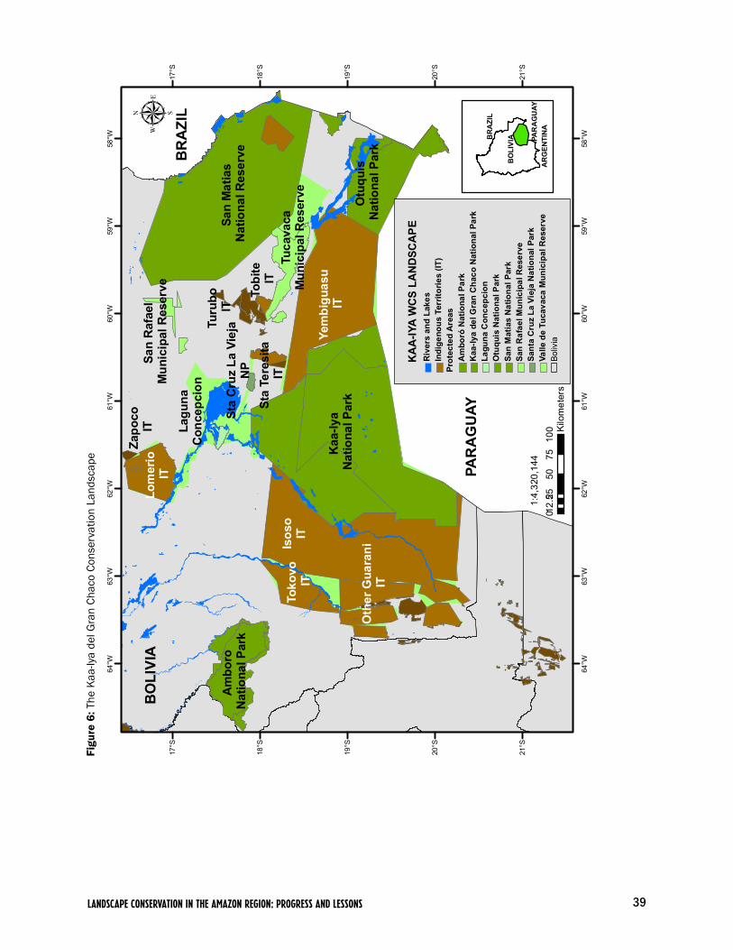
39LANDSCAPE CONSERVATION IN THE AMAZON REGION: PROGRESS AND LESSONS
Figu
re 6
: The
Kaa
-Iya
del G
ran
Chac
o Co
nser
vatio
n La
ndsc
ape
PAR
AG
UAY
Isos
oIT
Yem
bigu
asu
ITK
aa-Iy
a N
atio
nal P
ark
Otu
quis
N
atio
nal P
ark
Toko
vo
IT
Sta
Cru
z La
Vie
jaN
P
Turu
bo
IT
Tuca
vaca
Mun
icip
al R
eser
ve
San
Mat
ias
Nat
iona
l Res
erve
Lagu
na
Con
cepc
ion
Am
boro
N
atio
nal P
ark
Oth
er G
uara
ni
IT
Sta
Tere
sita
IT
Tobi
te
IT
Lom
erio
IT
Zapo
co
IT
BR
AZI
L
San
Raf
ael
Mun
icip
al R
eser
ve
58°W
58°W
59°W
59°W
60°W
60°W
61°W
61°W
62°W
62°W
63°W
63°W
64°W
64°W
17°S
17°S
18°S
18°S
19°S
19°S
20°S
20°S
21°S
21°S
BO
LIVI
Aµ
025
5075
100
12.5
Kilo
met
ers
1:4,
320,
144
KA
A-IY
A W
CS
LAN
DSC
APE
Riv
ers
and
Lake
sIn
dige
nous
Ter
ritor
ies
(IT)
Prot
ecte
d A
reas
Am
boró
Nat
iona
l Par
kK
aa-Iy
a de
l Gra
n C
haco
Nat
iona
l Par
kLa
guna
Con
cepc
ion
Otu
quis
Nat
iona
l Par
kSa
n M
atía
s N
atio
nal P
ark
San
Raf
ael M
unic
ipal
Res
erve
Sant
a C
ruz
La V
ieja
Nat
iona
l Par
kVa
lle d
e Tu
cava
ca M
unic
ipal
Res
erve
Boliv
ia
BO
LIVI
A PAR
AG
UAY
BR
AZI
L
AR
GEN
TIN
A

40 Wildlife Conservation Society | WORKING PAPER NO. 34
Mad
idi
Nat
iona
l Par
k an
d N
AIM
Apo
loba
mba
NA
IM
Taca
na I
IT
Taca
na II
IT
Sant
a R
osa
Mun
icip
al
Res
erve
Pilo
n-La
jas
Bio
sphe
re R
eser
ve
and
IT
Mos
eten
IT
BO
LIVI
APE
RU
San
Jose
de
Uch
upia
mon
as IT
Leco
s-La
reca
ja
ITAra
ona
IT
Leco
s-A
polo
IT
Beni River
Madid
i Riv
er
Titic
aca
Lake
BR
AZI
L
64°W64
°W
65°W65
°W
66°W66
°W
67°W67
°W
68°W
68°W
69°W
69°W
70°W
70°W
63°W
12°S
12°S
13°S
13°S
14°S
14°S
15°S
15°S
16°S
16°S
µ
025
5075
100
12.5
Kilo
met
ers
MA
DID
I WC
S LA
ND
SCA
PER
iver
s an
d La
kes
Sant
a R
osa
Mun
icip
al R
eser
veIx
iam
as M
unic
ipal
Res
erve
Apo
loba
mba
Nat
ural
Are
a of
Inte
grat
ed M
anag
emen
tPi
lon-
Laja
s B
iosp
here
Res
erve
and
Indi
geno
us T
errit
ory
San
Jos
e de
Uch
upia
mon
as In
dige
nous
Ter
ritor
y M
oset
enes
Indi
geno
us T
errit
ory
Lec
os-L
arec
aja
Indi
geno
us T
errit
ory
Lec
os A
polo
Indi
geno
us T
errit
ory
Mad
idi N
atio
nal P
ark
and
Nat
ural
Are
a of
Inte
grat
ed M
anag
emen
t T
acan
a I I
ndig
enou
s Te
rrito
ryTa
cana
II In
dige
nous
Ter
ritor
yA
raon
a In
dige
nous
Ter
ritor
yB
oliv
ia1:
3,99
6,60
7
Ixia
mas
M
unic
ipal
Res
erve
BO
LIV
IA
BR
AZI
LPE
RU
Figu
re 7
: The
Gre
ater
Mad
idi C
onse
rvat
ion
Land
scap
e

41LANDSCAPE CONSERVATION IN THE AMAZON REGION: PROGRESS AND LESSONS
Figu
re 8
: The
Cau
ra R
iver
Bas
in C
onse
rvat
ion
Land
scap
e
Abr
ae
Dec
reed
Are
a
Abr
ae
Dec
reed
Are
a
Abr
ae
Dec
reed
Are
a
Non
Tim
ber
Man
agem
ent A
rea
Mul
tiple
Use
s IT
Abr
ae
Dec
reed
Are
a
Hig
h Pr
eser
vatio
n IT
Spec
ial
Man
agem
ent A
rea
and
IT
Caura River
Paragua River
61°W
61°W
62°W
62°W
63°W
63°W
64°W
64°W
65°W
65°W
66°W
66°W
7°N
7°N
6°N
6°N
5°N
5°N
4°N
4°N
BR
AZI
L
VEN
EZU
ELA
µ
025
5075
100
12.5
Kilometers
CA
UR
A R
IVER
WC
S LA
ND
SCA
PER
iver
sPr
otec
ted
Are
as -
Indi
geno
us T
errit
orie
sC
aura
Lan
dsca
pe
Abr
ae D
ecre
ed P
rote
cted
Are
a Sp
ecia
l Man
agem
ent A
rea
and
Indi
geno
us T
errit
ory
Hig
h Pr
eser
vatio
n In
dige
nous
Ter
ritor
yM
ultip
le U
ses
Are
a In
dige
nous
Ter
ritor
yN
on ti
mbe
r Man
agem
ent A
rea
Vene
zuel
a
1:3,222,316
VEN
EZU
ELA
BR
AZI
L

42 Wildlife Conservation Society | WORKING PAPER NO. 34
the construction of highways and other infrastructure that accompanies the eco-nomic growth stimulated by hydrocarbons. A second part of the threat arises from the transformation of the regional economy (and associated changes in land use), one of the outcomes of the growing role of the hydrocarbon industry.
Other issues include a lack of baseline information relevant for conservation and management regarding biodiversity, threatened species, and conservation issues in the region, coupled with a weak national capacity for biodiversity research, and a few trained professionals capable of conducting sustainable natural resource programs. In addition, local and regional communication frameworks are weak, as are local government and protected area administra-tions, as witnessed in the overall lack of integrated and coherent regional and local land-use planning. Among the results of these shortcomings is the paucity of much-needed alternative sustainable income options for local people, a situ-ation that perpetuates unsustainable resource extraction practices.
Additionally, currently existing government administrative bodies need assistance in alleviating the majority of the population’s weak appreciation of conservation and its benefits, as well as in addressing the significant and problematic land tenure disputes and conflicts between local development and conservation plans. In summary, the region suffers from the weak regulatory framework of its extractive sector, and the lack of a strategy for financial sus-tainability or a long-term vision for its own sustainable development.
The context for addressing these complex issues is further complicated by Bolivia’s continuing political crisis. This means that organizations that in principle represent the interests of indigenous people have become increasingly politicized along party lines, and with this politicization, problems of represen-tativeness and legitimacy, political patronage, clientelism and mismanagement of resources have become particularly acute in many organizations. Indeed, in terms of political independence and management capacity, most indigenous organizations in Bolivia are weaker today than they have been for 20 or more years. In this context, demands on the few organizations that are not part of this overall pattern to exercise leadership have grown dramatically. CABI for example faces the challenges of being called on to respond with sound proposals and leadership far beyond the management issues facing the Kaa-Iya del Gran Chaco Landscape
Clearly, community-based natural resource management is a long-term objective, and one of the lessons of the partnership between WCS and CABI has been that as an organization becomes stronger, management does not become easier because the challenges that it is called on to address become larger and more complex. The multidisciplinary team that WCS and CABI have put in place is well aware of the social implications of working on this issue, and the strength of the interests that do not wish their efforts well. We need to press ahead with enlarging and broadening the constituency for conservation in the landscape, continue to address the technical and administrative challenges to biodiversity conservation and sustainable use of renewable resources, and develop the financial tools that will allow current achievements to be the build-ing blocks for future success.
We need to
press ahead with
enlarging and
broadening the
constituency for
conservation in
the landscape,
continue to
address the
technical and
administrative
challenges to
biodiversity
conservation.
43LANDSCAPE CONSERVATION IN THE AMAZON REGION: PROGRESS AND LESSONS
2.1.6. The Greater Madidi Conservation Landscape (Bolivia)
Background
WCS was one of several national and international conservation organizations that provided the Bolivian government with technical advice during the process of creating Madidi National Park in the early 1990s (Figure 7). Nevertheless, WCS only deepened its work in the Greater Madidi Landscape in mid-1999 with the support of the United States Agency for International Development (USAID) and matching private funds, as part of the WCS Living Landscapes Program. The following year WCS augmented this work with a project to assist in the consolidation and management of the Tacana Indigenous Community Land, and began to develop the Madidi protected area management plan project in association with Cooperative for Assistance and Relief Everywhere (CARE) Denmark and Bolivian Protected Area Service (Servicio Nacional de Áreas Protegidas, or SERNAP). The program has also been supported by the John D. and Catherine T. MacArthur Foundation since 2000, and through a grant to the WCS Amazon Andes Conservation Program from the Gordon and Betty Moore Foundation since 2003.
Major Accomplishments to Date
Titling completed of 372,000 ha of the Tacana TCO. In July 2003, the first and largest portion of the Tacana I TCO was legally titled by the Bolivian govern-ment. Spanning 325,327 ha of lowland tropical forest and savanna immediately adjacent to the Madidi protected area, this was identified early in the Greater Madidi Landscape Program as a key area for conservation interventions and will be critical for the sustainable development and conservation of northern La Paz (Painter et al. 2006). In June 2005, a second portion of the Tacana I TCO was legally titled by the Bolivian government, with over 46,667 ha of piedmont forest at the base of the Andes and directly bordering and/or overlapping with the Madidi protected area boundary, this was identified as a key compensation area by the Tacana because it contains traditional use areas of three Tacana communities, is a culturally important area because of the religious significance of the hills, and offers critical watershed protection for many of the lower-lying villages within the Tacana I TCO.
We have also supported the titling of 238,160 ha of the Lecos Apolo TCO and 62,781 ha of the TCO Lecos Larecaja TCO. We hope that these TCOs and the Tacana II TCO in the northernmost part of the landscape will be fully titled in the next year or two.
Completion of Madidi and Pilón Lajas management plans. The management plan for the Madidi National Park and Natural Area of Integrated Management has been approved by Bolivia’s SERNAP and by the protected area’s manage-ment committee. Replicating and improving on the experience with the Madidi protected area, we also provided the principal technical support to the protected area service and the Tsimane and Moseten Regional Council (Consejo Regional Tsimane Mosetén, or CRTM) in the development of Pilón Lajas Biosphere and Indigenous Territory Management Plan and Life Plan.
44 Wildlife Conservation Society | WORKING PAPER NO. 34
The process and resulting document have been recognized as a model for protected area planning and management across the country.2 The process included a thorough and multidisciplinary documentation and analysis of exist-ing biological and socioeconomic information, which was then used in a highly participatory landscape-scale planning process with local people and authorities in the protected area and its area of influence. The management plan identi-fied a series of priority actions over the next five years, including a realistic monitoring strategy. The proposed Madidi protected area tourism regulations, the first tourism regulations for a protected area in Bolivia, were also formally approved by the Bolivian government, including observations by the Tourism Viceministry, with implementation underway. This is now being adjusted for consistency with tourism regulations developed by SERNAP to be applied throughout Bolivia’s protected area system.
Description of biodiversity in the landscape. Bird surveys across the landscape have increased the number of confirmed bird species for Madidi from the 755 in 1999 to 905 bird species (Hennessey 2007). Several new records and/or rediscoveries for Bolivia and the park have also been documented for mam-mals and birds (Hennessey, 1999; Wallace & Painter, 1999; Tarifa et al., 2001; Hennessey, 2002; Hennessey & Gómez, 2002; Rios-Uzeda et al., 2004; Felton et al., 2006).
Mammal surveys have detected the presence of several iconic species. Among them are the short-eared dog (Atelocynus microtis), bush dog (Speothos venati-cus), jaguar (Panthera onca), giant river otter (Pteronura brasiliensis), margay (Leopardus wiedii), pejiche (Priodontes maximus), puma (Puma concolor), tapir (Tapirus terrestris), collared peccary (Pecari tajacu), and brocket deer (Mazama americana). We also have observed the maned wolf (Chrysocyon brachyurus) on the Pampas del Heath, within Madidi National Park (Ayala, 2007). Primate diversity is high, including capuchin monkeys (Cebus albifrons and Cebus libidinosus) squirrel monkeys (Saimiri boliviensis), howler monkeys (Alouatta sara) and spider monkeys (Ateles chamek), all of these being priority species for conservation due to their vulnerability to hunting and tourism pres-sures (Ayala, 2007).
In the Upper Madidi area we found one of the highest densities for a primate species. The spider monkey (Ateles chamek) was living in a density of 72 ind./km2 which indicates that the area is very important for the conservation of this species (Owen, 2004). In November 2007, preliminary studies on two Bolivian endemic primates, the Beni titi monkey (Callicebus modestus) and Olalla’s titi monkey (Callicebus olallae), suggest that they are clearly separate subspecies and that current separate species status is probably warranted (work carried out in partnership with the Institute of Molecular Biology and Biotechnology).
Evaluation of the distribution and abundance of the marsh deer (Blastocerus dichotomus) has indicated a high density inside and outside the park (0.2-0.4 ind./km2), this estimation establish a population of approximately 2500 marsh deer north of La Paz (Gómez y Ríos-Uzeda, 2004). (Ríos-Uzeda, unpublished data), which is one of the more important populations detected within the dis-tribution range of this species.
2 Because of social con-flicts in the area the management plan is not recognized by the Apolo Campesino Federation. Although they have not presented specific objec-tions to its content, it is necessary to proceed with a socialization effort with them in order to ensure complete appropriation.
Bird surveys across
the landscape have
increased the num-
ber of confirmed
bird species for
Madidi from the
755 in 1999 to
905 bird species.

45LANDSCAPE CONSERVATION IN THE AMAZON REGION: PROGRESS AND LESSONS
We have also completed up-to-date databases for mammals, birds, amphib-ians and reptiles linked to a GIS. Our geographic and biological information system is recognized by all institutions working in the landscape and has been installed in SERNAP’s central office, Madidi, Pilón Lajas, Consejo Indígena del Pueblo Tacana (Indigenous Council of the Tacana People, or CIPTA), and Consejo Regional Tsimane-Mosetén (Tsimane and Mosetén Regional Council, or CRTM) offices. The system has also provided information to support the work of Conservation International (CI), the Amazon Conservation Association (ACA), Swiss Workers Assistance (Ayuda Obrera Suiza, or AOS), German Development Service (DED) and others.
New monkey species and naming auction. The naming auction for the new species of titi monkey (Callicebus aureipalatii) discovered by WCS researchers in Madidi (Wallace et al. 2006) generated significant and positive press coverage for Madidi, Bolivia, and the importance of wilderness areas in general. The auc-tion also raised $650,000 to kick-start a trust fund for Madidi, which is man-aged by Bolivia’s Foundation for the Development of the National Protected Areas System (Fundación para el Desarrollo del Sistema Nacional de Áreas Protegidas, or FUNDESNAP). The interest generated by the fund has averaged around $40,000/year, and now covers the salaries of ten additional park guards presently working in Madidi, a 50 percent increase in park guards from the previous year.
Landscape Species Research. At the program’s research station on the Hondo River, we radio-collared and tracked 18 white-lipped peccaries over two years, confirming the wide-ranging behavior of this species with home ranges between 40 and 110 km2 (Ayala et al., in prep.). These home ranges are among the larg-est estimates for this species anywhere. Density estimates for white-lipped pec-caries have been gathered at five locations across the landscape. Results suggest that populations are recovering within the park and are able to resist current levels of subsistence hunting in more remote areas of the TCO Tacana (Gómez et al., 2008). Aerial censuses of marsh deer also provided the first population estimate in Bolivia (Gómez & Rios-Uzeda, in press). Jaguar population surveys at five locations across the landscape establish Greater Madidi Landscape as a stronghold for jaguar population with a high density estimation of 1 to 5.1 jaguars per 100 km2 (Ayala & Wallace, in prep.). We have also shown that standard camera trapping is a valid technique for estimating spectacled bear densities; results for this areas showed an actual density of 4-6 bears per 100 km2 (Rios-Uzeda et al., 2007). This information will help determine the real conservation status of this regionally threatened species (Rios-Uzeda et al., 2007). In addition, we have established that the Andean condor can be individ-ually recognized at carcasses, and we have estimated the population size across the Apolobamba and Madidi Protected Areas. The condor population is small compared to other landscape species, numbering between 80 and 150 condors (Rios-Uzeda & Wallace, 2007). It is critical to assess long-term viability and the degree of isolation to design appropriate management protocols for this threatened species and Bolivian icon.
Jaguar popula-
tion surveys at five
locations across
the landscape
establish Greater
Madidi Landscape
as a stronghold for
jaguar population
with a high density
estimation of
1 to 5.1 jaguars
per 100 km2.

46 Wildlife Conservation Society | WORKING PAPER NO. 34
The spatial needs of landscape species have been included in a gap analysis for the Bolivian Parks System (Ledezma et al. 2004). The gap analysis seeks to identify biomes important for conservation, that are either not included in the protected area system or are underrepresented. Landscape species analysis allows authorities to assess the extent to which the country’s protected areas are covering sufficient portions of critical habitat to ensure the viability of the wildlife living there. Our analyses indicate that healthy populations of white-lipped peccary and vicuña are achievable within the Madidi Landscape. The vicuña (Vicugna vicugna) habitat extends over the Ulla Ulla plateau inside the Apolobamba area, and its population is the most important in Bolivia. Annual censuses between 1999 and 2005 have shown a marked increase in the vicuña population. In 1999, 7,522 vicuña were recorded; in 2000, 8,245; in 2001, 8,299; in 2002, 8,556; in 2003, 10,694; in 2004, 10,250; and in 2005, 10,350 (Nallar, Gómez, Loayza, Casilla and Velasco, 2003). This demonstrates the effective protection of the species within the Apolobamba protected area. For white-lipped peccaries estimates of population size are about 100,000 individu-als over the entire region (Gómez and Wallace, unpublished). For spectacled bear and jaguar, the landscape represents an important continental stronghold, although populations may not meet newly published upper minimum viability requirement estimates without extending north into southern Peru and further south into the Bolivian Yungas and Beni grassland-forest interface (Wallace et al. 2007).
Population of the giant river otter (Pteronura brasiliensis) was surveyed on the Madidi River and relative abundance was estimated at 0.106 ind./km of river, with 4 groups identified in the study area (Ayala & Wallace, submitted). Recent sightings of this species on the Hondo and Tuichi Rivers suggested that the protection of this species in Madidi has been very effective and populations are recovering.
Human landscape models improved. The completion of Participatory Rural Appraisals, micro-zoning and planning processes for the communities in Pilón Lajas and the Tacana II TCO have complemented the human landscape model, providing new accurate information for these management areas for the first time. Overall, we have carried out 151 community diagnosis studies: 42 in and around the Madidi protected area, 20 in the Tacana I TCO, 4 in the Tacana II TCO, 35 in and around Pilón Lajas, 17 in the Lecos Apolo TCO, and 33 in the Lecos Guanay TCO. In addition to the improved information regarding the biological and human landscape we have developed a monitoring strategy for the Madidi and Pilón Lajas protected areas, linked to a GIS, which is being implemented by the park guards.
Micro-zoning and community management initiatives. The natural resource access, use, and management regulations for the Tacana TCO clearly establish who has access and/or the rights to utilize the TCO’s natural resources and under what conditions, and specifies a series of standard management practices for specific resource types. This process highlighted the need for micro-zoning within the Tacana TCO which will double as an official territorial zoning and land-use plan for the Bolivian government.

47LANDSCAPE CONSERVATION IN THE AMAZON REGION: PROGRESS AND LESSONS
We have developed community natural resource management projects across the landscape, including incense, chocolate, forestry, tourism, fishing manage-ment, ornamental fish, native bee honey production, and handicrafts. Many of our co-management projects have extended to additional communities, gener-ating supra-communal systems. This result in itself is a reflection of the power of these community projects and their potential for being self-sustaining. For example, the Tacana TCO now has 14 community forestry initiatives involving the management of some 59,082 ha, with more than half already with approved management plans and generating economic benefits, and 140 ha of certified native and organic cacao groves. The Tacana Native Bee Honey Producers Association won a $32,500 grant from the Protection and Sustainable Use of the Environment Foundation (Fundación para la Protección y Uso Sostenible del Medio Ambiente, or PUMA) to increase production and establish a com-mercial operation.
Subsistence hunting management projects to assess management needs and take steps to ensure long-term sustainability are continuing in six communities, including all of those in the entire lower Beni portion of the Tacana TCO. We have valued the economic importance of subsistence hunting at $37 to $94 per month per family. Communities have made preliminary management deci-sions regarding the reduction in harvesting of locally threatened wildlife spe-cies: marsh deer, lowland tapir, black spider monkey, and red howler monkey. Additional communities have recently requested our involvement, allowing us to move toward a hunting management plan for the entire Tacana TCO, based on source-sink management models.
Replication of the Tacana indigenous territorial planning in neighboring TCOs will permit us to complement the protected areas with an estimated post-land titling area of an additional 853,707 ha under indigenous territorial planning.
Co-management proposal for Madidi Protected Area developed. Given the current context in Bolivia, our biggest success has been demonstrated by the defense of the national protected area service, and specifically in Madidi and Pilón Lajas. With WCS’s support, the Greater Madidi Conservation Programs have worked with surrounding indigenous territories, as well as the municipal-ity of Ixiamas, which has been critical to establishing a constituency for con-servation in the region. The Tacana, Tsimane, Leco, and Quechua-Tacana com-munities came together in September 2007, and since then have been working to establish an alliance through the La Paz Indigenous Peoples Council and push a common agenda between the National Confederation of Indigenous Peoples (CIDOB) and the Bolivian government to work for the consolidation of the protected area service, develop new mechanisms for the participation of local people (co-management), and defend its institutionality. During this period, Tacana, Quechua-Tacana, and Leco communities supported the weakened park guard corps to evict illegal timber extractors and settlers, in particular from the lower Tuichi Valley. This support will remain critical in order to demand best practices by purported future large energy and infrastructure development projects in the region.
Tacana, Quechua-
Tacana, and Leco
communities
supported the
weakened park
guard corps
to evict illegal
timber extractors
and settlers, in
particular from
the lower Tuichi
Valley.

48 Wildlife Conservation Society | WORKING PAPER NO. 34
Economic evaluations with CSF of proposed roads in the landscape and eco-nomic benefits of the protected area. We have produced and distributed three publications with the Conservation Strategy Fund (CSF) on the economic ben-efits of the protected area to the region, the economic feasibility of the proposed Azariamas-Tumupasa road, and the economic feasibility of and impacts on protected areas of the Northern Corridor linking La Paz–Guayaramerin and Cobija.
Collaboration with municipal governments. We have also collaborated with municipal and local government officials, most notably on the creation and management design phase of a 37,000 ha Municipal Tourism Reserve in one of the most ecologically important locations of this landscape, the site of the Upper Madidi jaguar censuses. In addition, the Apolo Municipal Territorial Plan was developed through a subcontract with Conservation International, using as a base WCS’s extensive biological, social, and spatial knowledge and data.
Major Conservation Issues
The Greater Madidi Landscape is a culturally diverse region. The high elevation plains are home to the Aymara people, and the Andean valleys are dominated by the most numerous indigenous group in Bolivia, the Quechua. At mid-elevations around the towns of Apolo and Guanay there still remain a few Leco communities. In the lowlands, numerous indigenous groups are present includ-ing the Tacana, Tsimane, Mosetén, Araona, and Ese'ejas. Various mestizo com-munities are also present in the lowlands, as are more recent colonist settlers from the highlands. In total, the landscape is home to around 175 towns and villages, with a population approaching 125,000.
The Greater Madidi Landscape is subject to a wide array of threats, very broadly divided into physical or direct threats to biodiversity and more indirect problems such as institutional or political weaknesses. Physical threats include proposed oil and natural gas ventures that would directly affect the Tuichi, Hondo, and Quiquibey Valleys in Madidi and Pilón Lajas Protected Areas. Given the regional autonomy process currently underway in Bolivia, this immi-nent threat is likely to become more intense over the next five years. Significant gold mining and urban pollution in the highlands pose a significant threat to aquatic systems in the lowlands. Recent gold mining along the Tequeje River in the lowlands is a further concern. Another looming threat to the landscape is the effect of the proposed dams in the Madeira of Brazil, as well as possible Bolivian dams linked to the initiative.
Several proposed road construction projects will occur in the next five years, including: the current construction of the southern branch Inter-Oceanic Highway in neighboring southern Peru; the soon-to-be paved “Northern Corridor” (La Paz-Yucumo-Rurrenabaque-Riberalta) that passes just to the east of the landscape and is likely to have profound effects on the local economy; the “Bi-oceanic Corridor” that will pass just to the north of the landscape through Peru and Brazil; and smaller projects such as the Ixiamas-Chive road that will now pass just to the east of the northern section of the Madidi protected area.

49LANDSCAPE CONSERVATION IN THE AMAZON REGION: PROGRESS AND LESSONS
These projects in combination with both spontaneous and directed colonization will have major effects on lowland forest cover. Indeed, recent political and social developments in the country and the push towards regional autonomy have increased the pressure on the Bolivian government in terms of this coloni-zation. The northern Ixiamas area has been identified as a priority for directed colonization efforts.
Overexploitation of natural resources, including habitat destruction for agriculture, livestock production, and associated grazing, is a serious problem. Selective logging initiatives, commercial and unsustainable subsistence hunting, fishing and non-timber forest product exploitation, fire outbreaks related to agriculture, and human-animal conflicts, (particularly those concerning live-stock loss) all threaten the vitality of the area’s wildlife and wild lands.
Indirect threats are no less important and include gaps in the available infor-mation regarding distribution and population status of key threatened species and specific conservation issues in the region. This is coupled with a scarcity of professionals capable of conducting sustainable natural resource programs. Local and regional communication frameworks are weak, as are local govern-ments and protected area administrations, as witnessed by the overall lack of integrated and coherent regional and local land-use planning. Among the results of these shortcomings is the paucity of much needed alternative sustainable income options for local people.
Additionally, existing administrative bodies need assistance in alleviating weak appreciation of the benefits of conservation, as well as in addressing the problematic land tenure disputes between local development and conservation organizations. In sum, the region suffers from its weak extractive sector regula-tory framework and lack of strategies for financial sustainability or long-term vision for sustainable development.
2.1.7. The Caura River Basin (Venezuela)
Background
In the last decade, WCS implemented a conservation program focused on the fisheries of the Lower Caura (Figure 8). A complete description of the water-shed was compiled and a conservation strategy for the riparian ecosystems was proposed as a result of this work (Vispo and Knab-Vispo, 2003). The research showed a steady decline of fish in the Lower Caura, and this was the basis for a fishing moratorium declared during the reproductive season in 2003. While a few local fishermen have resisted the moratorium, the general response has been positive due WCS’s parallel campaign and the fishermen’s association’s attempts to increase awareness of the long-term benefits of this measure.
Despite the positive outlook afforded by the collaborative efforts above, we have also determined that during a six month period in 2007, approximately 5,100 kg of fish taken for commercial purposes were hauled into the main ports of the Lower Caura and in the confluence area (where the Orinoco River meets the Caura River). For the Lower Caura, the Morocoto (Piaractus brachypomus) represented 51% of the total catch, and the Blanco pobre (Barcyplatystoma vaillanti) and Rayao (catfish species, Pseudplatystoma spp.) represented 20%
50 Wildlife Conservation Society | WORKING PAPER NO. 34
and 14% of the total catch respectively. During the rainy season, the Morocoto (Piaractus brachypomus) contribution went up to 85% of the total catch. Of the fifteen species registered in catches during the rainy season throughout the confluence zone, the Curbinata (Plagioscion squamosissimus) accounted for 46% of the total catch.
We continue to monitor fish populations to determine if the measure has had a positive impact. Nevertheless, other factors need to be controlled before posi-tive change can occur. Our work also involves monitoring of fish populations in the spawning lagoons. Fishermen from other regions stray into these lagoons and fish with “barbasco”, a plant-derived poison. This affects not only the fish, but also all of the birds and mammals that gather together in these water bod-ies. We are in the process of documenting this activity in order to propose the restriction of fishing in these areas.
Between 2000 and 2004, WCS in association with the Venezuelan Association for the Conservation of Natural Areas (Asociación Venezolana para la Conservación de Áreas Naturales, or ACOANA), conducted a water-shed-wide inventory and habitat mapping exercise for small mammals. This work resulted in the discovery of 103 new species for the region and three species new to science. During this inventory, two indigenous parabiologists were trained in monitoring techniques. Also, between 2003 and 2004, WCS and ACOANA developed a conservation model for the indigenous territory based on consultations with 10 indigenous communities in the Upper Caura (see below). As a result of this work, in 2004 ACOANA conducted a pilot community-based hunting assessment in the community of Boca de Nichare, and is now working on two more projects independent of WCS. Since 2006, efforts have concentrated on working with local indigenous communities and non-indigenous fisherman to establish natural resource management plans and associated monitoring plans.
Major Accomplishments to Date
Our work in Caura was initially structured around a single objective: to assist local indigenous communities in developing a conservation vision for their terri-tories. This was achieved by conducting community dialogues and consultations with 15 Ye’kwana and Sanema communities in order to assess their resource management needs and perception of threats. Three cycles of information con-solidation and posterior consultation with the communities were conducted until a final conceptual model was approved by the individual Ye’kwana com-munities involved and Kuyujani, the indigenous organization that represents the Ye’kwana and Sanemas people of Venezuela.
As a result of this exercise, WCS, ACOANA, and the Ye’kwana had a clearer picture of the threats to the region and the tasks ahead. In addition to helping identify priority actions to be taken, it also helped to construct a broader view of the Caura Watershed as a whole, which requires work with non-indigenous ribereño populations. Our main goal became to ensure the conservation of the
Our main goal
became to ensure
the conservation
of the Caura’s eco-
systems and bio-
diversity through
adequate regula-
tions and legisla-
tions of economic
activities in the
lower parts of the
watershed and by
promoting sus-
tainable resource
management in the
upper parts of the
watershed.

51LANDSCAPE CONSERVATION IN THE AMAZON REGION: PROGRESS AND LESSONS
Caura’s ecosystems and biodiversity through adequate regulations and legisla-tions of economic activities in the lower parts of the watershed and by promot-ing sustainable resource management in the upper parts of the watershed. Thus, we intend to focus our actions in the heart of the watershed (Lower Caura and the minor watershed of the Erebato River in the Upper Caura). This would cover approximately 48% of the total Caura hydrographical watershed area including its tributaries. These focal regions include most settled areas in the Lower and Upper Caura, where there is a lot of pressure on the natural resources.
Given the Caura’s extraordinary conservation importance and the potential for having a significant conservation impact, we have conducted a number of other activities, which were not part of the original plan for our pilot activity in Caura. These have included:
1) A one-year evaluation with the Ye’kwana of the hunting pressures on mam-mals at Boca Nichare in the mid-watershed. ACOANA continued this effort in 2006 with the support of the Gordon and Betty Moore Foundation.
2) With support from the WCS Amazon Andes Conservation Program, our partner, ACOANA successfully presented a proposal for US $70,000 to IUCN-Netherlands. They have also conducted an analysis of changes in forest cover in the watershed over time, which shows how the agricultural frontier has expanded in and around the northern zone of the watershed.
3) During 2006 and 2007 we continued to strengthen environmental education and awareness activities in the Lower Caura non-indigenous and Upper Caura indigenous schools, increasing the capacity of schoolteachers to use the EEPE (Educación Ecológica en el Patio de la Escuela, or Schoolyard Ecology) method as a mean of increasing children’s capacity to relate to their environment, start-ing in their own schoolyard. This effort builds on earlier courses held in Maripa in 2005 under the direction of Dr. Peter Feinsinger, and seeks to invest in the understanding and capacity of future generations to manage the landscape’s natural resources. Activities involved hands-on inquiry as a tool for learning about conservation and landscape management. We also have been carrying out follow-up visits to support and advise Lower Caura indigenous and non-indigenous schoolteachers.
4) We continued prevention and awareness-building campaigns for local fisher-men and other communities through advertising and local press. During 2006 and 2007, we began printing and distributing our local monthly newspaper “The Miracle of the Caura” (“El Milagro del Caura”), and right now more than 500 units have been distributed per edition (with three editions in total) as well as other educational materials related to EEPE activities. Production of the newspaper has been carried out entirely by local students advised by WCS technical staff, and it has been well received by the local population.
52 Wildlife Conservation Society | WORKING PAPER NO. 34
5) We assisted in the formulation of a management plan for the Caura Forest Reserve and its protected areas, which increased use restrictions and incor-porated regular monitoring into the plan. WCS staff provided logistical and advising support to the technical staff of the Ministry of the Environment in the delineation of the regulation use plan proposed for the area. As a part of this process, during 2007 the ministry carried out a series of public consulta-tions at the national, regional, and local level in non-indigenous and indigenous communities in the watershed to jointly review the proposals established in the regulation decree for the reserve. These public consultations were organized by ministry staff trained by WCS. During these meetings, WCS staff developed an understanding of the role of the diverse actors involved and for the local com-munity perception.
Major Conservation Issues
The Caura Watershed in the Orinoco Basin has been described as one of the largest virtually untouched watersheds in tropical South America. It covers 4.5 million ha of Guiana Shield tropical moist forest, or 5% of the country.3 The biological diversity of this region is outstanding. The watershed is home to one third of the wildlife species reported for Venezuela and one half of those report-ed for the Guiana Shield. The Sarisariñama and Maigualida tepuy systems in the upper watershed and the presence of organisms of Amazonian and Guianan origin create a unique ensemble of organisms.
Social change associated with changes in the lifestyles of indigenous people, expanding development in the Lower Caura, and economic pressures generated by development processes outside the watershed pose major conservation chal-lenges for the Caura Basin. In the Upper Caura, the change from nomadic to sedentary lifestyles in the Ye’kwana and Sanema ethnic groups has resulted in concentrated impacts on the forests and wildlife of the region. Formerly, conu-cos (or small agricultural plots) were located in the richest soils, which allowed a very long turn-over cycle of the land. Nowadays, the plots are located in any soil found in the immediate vicinity of the settlements, and their turn-over cycles are concurrently reduced. As a result, conucos are cut more often in order to make up for the reduced fertility. To increase their reach to new harvesting areas, the Ye’kwana and Sanema now settling along the rivers, thus increasing their impact over the wildlife that depends on the riverside habitat.
In the Lower Caura, the Pemón, Hivi and Piapoco groups, as well as cre-oles, are fairly recent immigrants, from as far as the border with Colombia. This population outnumbers the two local indigenous groups (Ye’kwana and Sanema) and has increased the demand on resources. Two roads that connect Maripa and Trincheras with Ciudad Bolivar, providing access to the Orinoco, have facilitated extractive activities (mainly fishing and timber extraction) that supply outside markets and increase the opportunity for establishment of cattle farms.
3 The Guiana Shield has an extension of 2.5 million km2 that spans the south-ern side of the Orinoco Basin and includes some of the most pristine tropical lowlands of the world. It is estimated that this region produces close to 15% of the planet’s freshwater and contains a wealth of biological diversity rarely unsur-passed. It holds at least 20,000 vascular plant species, 35% of which are endemic, and 4,000 vertebrate species (55% of which are fishes) with an endemism that ranges between 10 and 20%. Concurrently, it also contains a wide ethnic diversity, but with one of the lowest human densi-ties among the tropical forests (0.6-0.8 ind/km2).
53LANDSCAPE CONSERVATION IN THE AMAZON REGION: PROGRESS AND LESSONS
Economic pressures from outside the watershed include: increased intake of fish by foreign fishermen, hydroelectric projects, and mining. Fishermen from neighboring areas often enter the Lower Caura and use fishing techniques that maximize capture rates. Particularly worrisome is the use of poison in the lagoons where fish congregate to spawn. Fishermen are exerting a significant pressure on turtle eggs, which has decreased the population.
Gold mining has traditionally occurred on a very small scale, concentrated mostly in the southern border (near Brazil) and the headwaters of Caura. However, mining has increased in neighboring watersheds (Paragua, Cuchivero, and Aro), and local inhabitants are concerned because these activities have been expanding into the Caura since August 2006. Although the Venezuelan govern-ment has adopted some radical control measures in the region, such as limiting the access of non-indigenous people to the Upper Caura through military con-trol and restricting control over gasoline expenditures in Maripa (where most of the local indigenous and non-indigenous people buy fuel for their boats), some gold miners are still operating in Caura, and consequently this constitutes a serious threat to the region. Deposits of kaolin, granite, and to a lesser extent diamonds, have been detected in the watershed. Plans to extract granite are already underway for the Monte Oscuro region in the northwestern margin of the region. A widespread diamond fever would be disastrous for the area.
Finally, the water volume of the Caura River is quite attractive for hydroelec-tric development projects. Two proposals are under discussion: the diversion of the river into the Paragua River, and the establishment of a hydroelectric plant in the Salto Pará waterfall. The first will cause a major imbalance in the hydraulic dynamics of the Lower Caura, endangering the fish of that region and changing the edaphic conditions of the ecosystems. The second, intended to support the hydroelectric plant at the Guri Dam, would involve the creation of power line corridors that will fragment the forests of the watershed.
These issues are compounded by institutional weakness and lack of land ownership by the area inhabitants. Despite the fact that almost all the ter-ritory is under one form or another of special management, the areas lack management plans and local presence by authorities. In addition, four separate government organizations manage the land (the Parks Authority, the Ministry of Natural Resources, Indigenous Ministry, and the State of Bolivar) and there is little coordination among them. The territorial claim by the Ye’kwana and Sanema overlaps all these Special Management Areas and National Parks, and there is no discussion as to how this overlap in authority could be resolved.
The threats faced by Caura are no different from those of many other regions, and they are benign when compared to other landscapes in the Amazonia. However, the biological importance of this region makes this a landscape with high priority and a high potential for success. Institutionally, the area can be complex and challenging. WCS has remained a neutral element, and is now recognized as a key player that could help bring together different local organizations. WCS staff in Caura have maintained excellent working relation-ships with different groups, including the most sensitive ones.
Despite the fact
that almost all
the territory is
under one form or
another of special
management, the
areas lack manage-
ment plans and
local presence by
authorities.

54 Wildlife Conservation Society | WORKING PAPER NO. 34
2.2. Cross-cutting Programs WCS has supported the landscape-based programs described above with a set of cross-cutting activities focusing on four major areas:
1) Supporting the landscapes in developing conceptual models and monitoring frameworks so they can better set priorities and document results;
2) Building the technical capacity of our own landscape-based teams and our partners.
3) Encouraging strong partnerships with local actors to build constituencies for conservation; and,
4) Providing cost-effective technical assistance that most individual landscapes would find difficult to provide for themselves.
Technical assistance for developing conceptual models and monitoring frame-works. The WCS Amazon Andes Conservation Program has worked closely with the WCS Living Landscapes Program (LLP) to provide technical assistance to each of the WCS Amazon Andes Conservation Program (AACP) landscapes to develop conceptual models, and use these as a basis for building monitoring frameworks that inform planning. By making explicit the long-term conserva-tion goals of the project, the specific biological attributes or targets that help focus and prioritize conservation investments, and the direct and indirect fac-tors that threaten conservation targets within the landscape, conceptual models allow us to be much clearer about what we need to monitor to ensure that our actions are really contributing to reaching our conservation goal. The concep-tual models also provide a common way of approaching landscape-based con-servation that makes it easier for the landscapes to share experiences with and learn from one another. All seven AACP landscapes have developed conceptual models and now have monitoring frameworks based on the models, except for Caura, which is still developing its long-term program.
State-of-the-art technical support for program landscapes. In coordination with the WCS Field Veterinary Program, we have worked closely with local com-munities in the Chaco and Madidi Landscapes to improve the management of domestic animals as a contribution to strengthening local productive activities, and to reduce the risk of disease transmission from domestic animals to wild-life. In Chaco and the Tacana TCO, and in the Greater Madidi Landscape, this effort now includes systematic epidemiological monitoring using participatory methods to detect zoonotic and vectoral diseases. We have also provided tech-nical staff from the seven landscapes, as well as local partners with training in general landscape ecology, and in methods for analyzing population and ecol-ogy data collected on key species in each landscape. Cross-cutting support has also been provided for region-wide species analyses, including tapirs, peccaries, and river dolphins.

55LANDSCAPE CONSERVATION IN THE AMAZON REGION: PROGRESS AND LESSONS
Capacity building. We have worked to build technical capacity by providing 10 fellowships for graduate study to key members of our own landscape-based teams, professionals working in partner organizations, and key members of local conservation communities. We have also continued to provide direct training via short courses and workshops on specific issues related to applied conservation research and planning and implementing landscape and species conservation programs. During the past year, over 100 people from our own programs and partner institutions have participated in these opportunities. At the institutional level, we have worked to help local partners build their techni-cal and administrative skills so that they are able to gather and process informa-tion, and secure and utilize resources more effectively.
Conservation finance. We have worked with the Mamirauá Sustainable Development Institute (IDSM) to develop a business plan for Mamirauá aimed at ensuring long-term financial support for its conservation program. We found that, while the resulting document provided important guidance for Mamirauá in its consideration of approaches to financial sustainability, it needed strengthening in two areas: (1) making the steps for implementing major recommendations clearer for IDSM program managers whose backgrounds are not in financial management, and (2) developing a more systematic approach to business planning so that the Mamirauá experience can serve as a resource to other landscapes in our program and in the Amazon. To strengthen the Mamirauá exercise in these two areas, IDSM and WCS worked with the Haas Business School of the University of California at Berkeley to produce a revised business plan that better meets these two needs. The resulting draft was com-pleted in July 2007 and adopted by IDSM in October. WCS and IDSM have produced a version of the business plan for public distribution, which will serve as a tool for supporting business planning in other landscapes.
Sharing experiences on building partnerships. Strong partnerships with local actors are a critical element of conservation. Partnerships with indigenous organizations are particularly important in Amazon conservation because of the substantial overlap between the lands claimed by indigenous peoples and lands critically important to biodiversity conservation. While our conservation objectives do not always mesh perfectly with the development aspirations of indigenous people, indigenous organizations often have knowledge of the local environment, an interest in defining alternatives to dominant development para-digms, and a capacity for mobilizing people that make them powerful partners when we succeed in clearly defining shared interests tied to concrete actions. Our partnerships with indigenous organizations are particularly strong in the Chaco and Madidi Landscapes, where indigenous partners have become the front-line advocates of protected areas. We have actively sought to share the Chaco and Madidi experiences with other program landscapes, where partner-ships with indigenous organizations are also key to long-term conservation suc-cess. To that end, we sponsored a visit by members of the Yasuní program to the Chaco, where they were able to exchange experiences with representatives of the CABI-WCS program. We have also undertaken an initiative to strengthen

56 Wildlife Conservation Society | WORKING PAPER NO. 34
the capacity of management committees to participate meaningfully in manage-ment decision-making in the protected areas with which they are associated. The program focuses on the management committees in the Kaa-Iya, Madidi, Yavarí, and Yasuní Landscapes, where indigenous organizations are, or should be, key actors in working with protected area managers.
Wildlife, management as a tool for expanding areas under protection. Wildlife management can be used as a powerful conservation strategy in the Amazon by enhancing the sustainable use of wildlife, conserving wildlife populations, imple-menting habitat conservation and in turn conserving the entire array of biodi-versity. Establishing non-hunted source areas, that are in fact fully protected areas, is an important component of wildlife management, which concurs with the cultural and socio-economics of the rural people. WCS has been developing a model for wildlife management in the Amazon Basin using WCS’s Amazon Landscape sites. This model is based on extensive research on wildlife popula-tions, human hunting practices, and landscape-level conservation approaches. The goals of this approach are to (1) assist in setting up wildlife management programs in WCS’s Amazon Landscape sites; (2) test and refine the wildlife management model in those sites; (3) demonstrate the model’s usefulness as a conservation strategy based on that experience; and (4) disseminate the wildlife management model throughout Amazonia. The major objective of the model is to increase the number of hectares under protection using the source–sink approach to wildlife management. The source areas of wildlife management are lands that communities are setting aside to insure sustainable wildlife use in the future. It is estimated that the local people within the WCS landscape sites have set aside 1,036,000 ha of wild lands that they are protecting as part of the implementation of the wildlife management model.

57LANDSCAPE CONSERVATION IN THE AMAZON REGION: PROGRESS AND LESSONS
3. LESSONS LEARNED

58 Wildlife Conservation Society | WORKING PAPER NO. 34
At the beginning of this paper, we noted that one important aspect of the landscape-based approach is that it involves accepting responsibility for how conservation is implemented in a particular setting. In the process of putting the Amazon Andes Conservation Program into action, we have learned many important lessons, among them (1) when areas protecting key portions of a landscape can be considered consolidated and expected to fulfill their missions reasonably well without continued support; and (2) the importance of building strong partnerships with key actors in a landscape in order to develop a shared land management vision.
3.1. Consolidating Protection of Conservation LandscapesAs we seek to conserve wildlife and key landscapes through a combination of protection and improved natural resource management, we need to consider at what point we can expect a protected area to offer minimum guarantees that it can do the job it was created to do. This provides a key parameter for judging when we can turn our attention to bringing new areas under protection, and what specifically should be the focus of our efforts in areas that have already been created. We have identified five institutional conditions that need to be met in order to have a reasonable expectation that a protected area will be able to fulfill its basic functions. These include:
a) Formal definition of conservation purpose. This usually defines the for-mal existence of a protected area, and may take several forms, including a supreme decree or law, a municipal ordinance, or a formal decision by an indigenous organization to define land use rules in the different areas of its territory. Normally, this definition includes a statement about the kind of protection extended (e.g., strict conservation versus limited production under defined conditions).
b) Land tenure. A title defines the exact limits of the protected area, ratifies the designated purpose (e.g., ranch, community lands, indigenous territory, national park, etc.), and designates an owner or steward responsible for pro-tecting the area’s physical integrity and ensuring that its actual use is consis-tent with the purpose defined in the title. Without a title, an area created by a supreme decree, or even a law, is subject to having its boundaries disputed and the authority of the entity responsible for its management questioned.
c) Management plan. The management plan defines what actions need to be carried out to fulfill the purpose of the protected area, and defines the geo-graphic spaces in which those actions are to be carried out. It provides the management entity with the technical support it needs in order to say that a particular area is suitable for certain types of activities (e.g., regulated tourism) but not others (e.g., grazing livestock), and defines the specific parameters within which the impacts of infrastructure like roads and gas pipelines need to be assessed. When prepared using participatory methods and approved through a transparent process, it sets an important precedent for how the area will be operated and creates a basis for strong effective governance.
We need to
consider at
what point we
can expect a
protected area to
offer minimum
guarantees that
it can do the job
it was created
to do.

59LANDSCAPE CONSERVATION IN THE AMAZON REGION: PROGRESS AND LESSONS
d) Incorporation into the development plans of the relevant jurisdictions. The authority and responsibility of the municipalities, prefectures, indigenous organizations, and other entities that may exercise jurisdiction over parts of a protected area are often ambiguous. As a result, the relevant jurisdictions frequently ignore the presence of a protected area when making land use plans and decisions about resource allocation. This leaves the protected area vulnerable to becoming a pawn in jurisdictional disputes. It also means that development investments are frequently at cross-purposes with the role of the protected area. Points a-c above are critical to ensuring that the develop-ment plans of these different authorities reflect the existence and mission of the protected area. When this happens, their development investments tend to reinforce, rather than undermine, the operations of the protected area, even if it is not considered a high priority.
e) Long-term financial plan. Protected areas must assume responsibility for planning their own financial futures when deciding how they will implement their missions. State funding is always vulnerable to changing short-term political priorities and the funding priorities of donors. Protected areas must develop their own revenue streams through user fees, corporate sponsorship, trust funds, and other means to increase the diversity of their funding sources and the stability of overall funding levels. Contingency plans should also set up essential tasks in the event of revenue shortfalls.
While the issues above include elements of internal management, they primarily relate to the insertion of a protected area into social and political contexts at local and national level, and the construction of a conservation constituency that can be mobilized on behalf of issues related to biodiversity conservation and the sustainable use of renewable resources. Most efforts to measure the consolidation of protected areas take the formal definition of con-servation purpose as a point of departure and include management plans as an indicator. They do not adequately consider issues of relations with municipal and departmental authorities and the resolution of land and land use conflicts, focusing instead the number of park guards, vehicles, guard posts, and the like. Our experience is that in the face of a land invasion or other organized action that challenges a protected area’s physical integrity, legitimacy and perhaps its legality, the number of park guards, vehicles, and guard posts are not decisive factors. On the other hand, to the extent that these five institutional conditions are met, protected areas can function relatively well, even with suboptimal resource endowments, and their options for improving conditions through their own initiative, without depending on governments and donors, are considerably expanded. Thus, these five factors are key as we assess the quality of protec-tion afforded by existing protected areas in our landscapes and set priorities for bringing additional areas under protection.
The seven landscapes in the WCS Amazon Andes Conservation Program are at different stages in meeting all five conditions. At one end of the continuum is Caura, which is beginning to define what the core area placed under protection in that landscape should be, and to devise a strategy for defining its conserva-tion status and purpose. There is no management plan, and no consideration
Our experience is
that in the face of
a land invasion or
other organized
action that chal-
lenges a protected
area’s physical
integrity, legiti-
macy and perhaps
its legality, the
number of park
guards, vehicles,
and guard posts
are not decisive
factors. On the
other hand, to the
extent that these
five institutional
conditions are met,
protected areas
can function
relatively well,
even with sub-
optimal resource
endowments.

60 Wildlife Conservation Society | WORKING PAPER NO. 34
of a protected area as such in the development plans of any of the relevant jurisdictions. In the absence of these, we have not yet begun working on a long-term financial plan. In contrast in the Chaco, the core protected area, the Kaa-Iya del Gran Chaco National Park, has been created, has a management plan, is making progress on putting together a long-term financial plan, and, as noted above, important areas have been titled. At the same time additional key areas are in the process of being brought under protection as part of the titling of the Isoceño indigenous territory and other lands adjacent to the park. Some work has been done in order to integrate the park into the development plans of relevant jurisdictions, but this is still in early stages. The situation in each of the seven landscapes is summarized in Table 2 below.
3.2. The Importance of Strong PartnershipsBuilding broad support for conservation depends on a critical mass of people from a variety of backgrounds identifying their own reasons for wanting to con-serve, not on their adopting the values of WCS. How successful conservation is in any given context is an outcome of how compelling those reasons are found to be. Our Amazon Andes Conservation Program has yielded valuable lessons about the importance of constructing solid partnerships with local actors for successful landscape-based conservation. Typically, these are based on shared interests associated with the objectives of conserving biological diversity and promoting sustainable resource use. While recognizing that these two objectives often exist in conflict with one another and that WCS and our partners do not always assign the same relative weight to each, we do recognize that both ele-ments are essential to any strategy that seeks to improve the quality of human life. Our relationships with local partners have resulted in five major achieve-ments, including:
a) The construction of lasting alliances based on explicit recognition of where the interests of WCS do, and don’t, coincide with those of our partners.
b) Collaboration in dealing more successfully with external threats than would be possible if WCS or our partners tried to address these issues on our own.
c) Increasing long term capacity for conservation and sustainable land manage-ment.
d) Construction of conservation constituencies.e) Learning from one another so that we and our partners are stronger than we
would be in the absence of our partnership.
Based on these achievements, WCS and our partners, have learned to draw on our differences as a source of strength and develop relationships of trust which have allowed us to accomplish more on behalf of our respective priorities.
Partnerships
arise out of the
experience of
carrying out
activities together,
overcoming
disagreements
in a way that
contributes to
building mutual
trust, developing
a shared vision,
and coming to
understand what
is in fact shared
and what is not.

61LANDSCAPE CONSERVATION IN THE AMAZON REGION: PROGRESS AND LESSONS
We have also learned that while partnerships need to be based on shared interests, the existence of these is not in itself a sufficient basis for a strong working relationship. Partnerships arise out of the experience of carrying out activities together, overcoming disagreements in a way that contributes to build-ing mutual trust, developing a shared vision, and coming to understand what is in fact shared and what is not. Partnerships depart from the understanding that as international conservation organizations, we must work within the legal frameworks of the countries where our programs are based, recognizing the rights and responsibilities of local, regional, and national actors, and that they must be the long-term stewards to ensure that conservation initiatives are sustained.
Table 2: Summary of Protection Status at WCS Amazon Landscapes
Conservation Landscape
Definition of Conservation Status
Land Title Management Plan Incorporated into Develop-ment Plans of Relevant Jurisdictions
Long-term financial plan
Caura State land under dif-ferent management categories including 1 National Park, 3 National Monuments, a Protective Zone and a Forest Reserve. None are under active management.
No No No No
Yasuní • YNP created via Ministerial Decree
• YBR created via Ecuadorian govern-ment request to UNESCO
• Potential for expan-sion of protection via municipal protected areas
• Waorani Ethnic Reserve created via Presidential decree
• Kichwa community lands titled under Ministry of Environ-ment
• Tagaeri-Tarome-nane Intangible Area declared by Presidential decree
• YNP no.• YBR no.• Waorani Ethnic
Reserve yes.• Kichwa community
lands in YNP yes.• Oil concessions
within YNP and Waorani Ethnic Reserve yes as concessions.
• YNP has a management plan that was never implemented and has now expired.
• YBR no.• Waorani Ethnic
Reserve no.• Kichwa community
lands in YNP yes.• Oil concessions in
YNP and Waorani Ethnic Reserve yes.
No. There is preliminary collaboration with municipal government of Orellana.
No
continued on next page

62 Wildlife Conservation Society | WORKING PAPER NO. 34
Yavarí Miri • ACRTT defined as a regional communal reserve. Elevation to national status in progress.
• Yavarí proposal under discussion by regional and na-tional authorities.
No • ACRTT has for spe-cific topics (e.g., wildlife manage-ment, aguaje palm management, con-trol and vigilance by management committee), but no overall plan.
• Yavarí no.
No No
Mamirauá/Amanã
Yes, as SDRs under jurisdiction of State of Amazonas
No • Mamirauá yes. • Amanã no.
Yes, at state government level.
Yes
Piagaçu Purus
Yes, as SDR under jurisdiction of State of Amazonas
No No Yes, at state government level.
No
Chaco • Yes. KINP exists via Supreme Decree.
• Isoceño TCO recognized as a claim by INRA.
• Work underway to expand areas under protection in neighboring TCOs and municipalities.
• KINP no, but planned.
• Isoceño TCO in progress.
• KINP yes. • Zoning proposal
and draft management plan completed for Isoceño TCO pending completion of titling process.
• One municipality has completed PMOT.
Partially. Elements exist, but not a complete plan.
Madidi • Yes, all three national protected areas exist via Supreme Decrees.
• TCO claims recog-nized by INRA.
• Work underway to expand areas under protection in neighboring TCOs and municipalities.
• National protected areas incomplete.
• Tacana I yes.• Other TCOs in
process.
• National protected areas Pilón yes, Madidi in review, Apolobamba in process
• Tacana I TCO yes.• Other TCOs in
process.• Apolo PMOT com-
pleted.• Ixiamas Municipal
Reserve in process• Ixiamas, San
Buenaventura, Guanay PMOTs in process, Pelechuco pending
Partially. So far in the cases of the Tacana TCO and the Apolo Municipal Land Manage-ment Plan.
No. Initial steps in progress.
Conservation Landscape
Definition of Conservation Status
Land Title Management Plan Incorporated into Develop-ment Plans of Relevant Jurisdictions
Long-term financial plan
continued from previous page

63LANDSCAPE CONSERVATION IN THE AMAZON REGION: PROGRESS AND LESSONS
Despite the important achievements that many of our partnerships have to their credit, the relationships underpinning them continue to require active engagement by both parties to keep it strong. This, combined with the fact that the biological, socioeconomic, and institutional objectives that compose sustainable conservation require substantial periods of time to achieve, means that effective conservation partnerships are necessarily long-term. Specifically, commitments are required that go well beyond the funding cycles and atten-tion spans of most donors. Thus, while donor funds can play a critical role in moving processes forward, partnerships cannot depend on donor funds alone. Institutions need to be prepared to commit significant amounts of their own resources, independently of the ebb and flow of donor interest, and to invest significant effort in finding ways to build local sources of support for conserva-tion. On the one hand, this requires the construction of a broadly shared land management vision, which includes the participation of local governments, private landowners, and other actors, to define areas for investment that are secure. On the other, it requires exploring how to work with private investors whose primary interests reside in other areas, but who may see promoting con-servation and sustainable land use as supportive of their business objectives.
In recent years, building partnerships between conservation organizations and organizations representing local people have suffered, as people concerned with the issues involved have dedicated more effort to buttressing rhetorical walls than to building bridges of understanding. Particularly damaging to efforts at striking an appropriate balance between promoting economic development and the conservation of biological diversity as keys to improving the quality of human life has been the conflation of sustainable development and biological conservation. Often, the two issues are treated as if they were inherently com-patible concepts, or even as if they referred to the same thing. This led to the expenditure of significant amounts of money on integrated conservation and development projects, which were often designed and implemented on the basis of internally contradictory sets of assumptions and objectives, and achieved predictably unsatisfactory results from both conservation and development per-spectives. Furthermore, as project implementers sought to force incompatible activities together as part of a single package, participatory approaches have often been replaced by decidedly top-down management attempting to respond to agendas that had little to do with local realities (e.g., Goldman, 2003).
Unfortunately, recognition of these shortcomings has only infrequently led to sharper analysis of the relationship between conservation and development needs in particular settings, and consequent improvements in how we seek to strike the appropriate balance. Rather, the voices on both sides have become increasingly shrill in asserting the transcendent righteousness of their respective positions, and more insistent on placing their efforts in a context that excludes the other perspective. Conservationists have often rejected what they regard as utilitarian views of nature, and insist that the conservation of biological diver-sity be justified in terms of its intrinsic value (e.g., Oates, 1999; Terborgh 1999). Framed in this way, the range of things that one might do becomes increasingly narrow, with the focus ultimately narrowing to more and better environmental
In recent years,
building partner-
ships between con-
servation organiza-
tions and organi-
zations represent-
ing local people
have suffered, as
people concerned
with the issues
involved have ded-
icated more effort
to buttressing rhe-
torical walls than
to building bridges
of understanding.

64 Wildlife Conservation Society | WORKING PAPER NO. 34
education, and more and better law enforcement, particularly as this relates to safeguarding the physical integrity of protected areas (e.g., Oates, 1999: 244-248; Terborgh 1999:199-200). The implication of this approach is that, given adequate information and encouragement, most people will come to share the conservationists’ perspective about the importance of conserving biological diversity, and that those who do not will be dealt with as a law enforcement problem. Thus, local people are seen as passive, uncritical recipients of educa-tion, or as a problem to be overcome; roles which leave little opportunity for meaningful participation in decision-making.
Grassroots advocates, on the other hand, argue that active involvement in decision-making about land use is a right of the people who depend on that land for their livelihoods, and a key element for more sustainable conservation (e.g., Schwartzman et al. 2000). Our program has been based on the premise that local people must be actively involved in land use decision making, out of respect for their rights, and because such involvement is a crucial element in strengthening and constructing the local conservation constituencies that are essential for long term success. However, we fear that the escalation in rhetoric has not always helped the cause of local land use decision-making, because advocates for local people too frequently present them as one dimensional “natural conservationists,” whose production aspirations have been, are, and will always be consistent with the goal of conserving biological diversity. In advancing this argument, they cease to be the advocates of the interests of real local people, and become the purveyors of an image of people who do not exist in real time or space (Redford & Sanderson, 2000). This fundamentally distorts the diverse and complex situations that form the contexts of rural peoples’ struggles to improve the quality of their lives, and places responsibility for the political viability of protected areas squarely on their shoulders, a burden that they cannot shoulder alone (Chicchón, 2000).
The partnerships constructed through WCS’s Amazon Andes Conservation Program are important because they show the potential for working within a structure of alliances that builds on the strengths distinct actors bring to the process of promoting biodiversity conservation as part of a regional land use strategy where improving the quality of life for humans is a central goal, and the different parties involved are respectful of one another’s reasons for being there. As Callicott and Mumford (1997: 35-36) propose, this allows two perspectives to co-exist and complement one another. One values nature for its own sake, and works to define and manage protected areas that do the best job possible of conserving biological diversity independently of human production goals. The other views nature as a hierarchically integrated set of ecosystems, with humans and their production systems forming an inescapable part. Both elements are essential to a sustainable landscape-level land use strategy, both in the sense of ensuring the conservation of biological diversity over time, and accommodating a dynamic vision of the needs and aspirations of local people.
65LANDSCAPE CONSERVATION IN THE AMAZON REGION: PROGRESS AND LESSONS
The framework of a partnership in which all parties participate actively and meaningfully provides the setting in which the relationship of these two elements of the strategy can be discussed and negotiated transparently. It also creates a context in which local organizations can develop a political strategy that builds on historical strengths while exercising their options to incorporate new elements into their production systems. When the space exists for such a diversity of options, the conditions are most favorable improving living condi-tions in a way that finds an acceptable relationship between conserving biologi-cal diversity and responding to human needs (e.g., McCabe 2003; Fratkin and Mearns 2003).
Partnerships between conservation organizations and local people are one important element in the opening of such a collaborative space, but they require dispensing with the mythology of natural conservationists as a way of avoiding the tough decisions about allocating land for meeting human production needs and for conserving biological diversity. They also require a recognition that we all share an interest in ensuring that our land allocation decisions are wise ones and that local people are partners in constructing the necessary wisdom, rather than as a problem to be dealt with through education and law enforcement. At the same time, the populations of local people with whom conservation organizations (and others) seek to work are not homogenous, but cross-cut by divisions of social class, gender, and ethnicity, all of which influence their visions of how land should be used and affect their interest in being partners.
One key for conservation organizations is to assess what sorts of institution-al relationships will provide linkages with those sectors of a population whose interests significantly overlap with their own, so that the resulting partnerships begin on solid footing. A second key, once a partnership is formed, is to work with our partners, political authorities, and other actors to create settings in which visions regarding land use can be discussed openly, and decisions regard-ing land allocation and use can be made in ways which, while not necessarily satisfying everyone, are sufficiently transparent and broadly supported so that decisions, once made, are respected. In such a context, all parties can be forth-coming about how they define their interests, what their agendas are for, and how an area should be used (or not). Conservationists and others may some-times find that they are not entirely pleased with the decisions that are made; but they can be sure that their point of view informed the decision-making process as part of a socially grounded, pluralistic approach and maximize the chances that ethical contentment, social respect, and real-world results (Lélé & Norgaard, 1996:363) are among the outcomes of their efforts.

66 Wildlife Conservation Society | WORKING PAPER NO. 34
Bibliography
Ayala, G. and R.B. Wallace. In prep. Jaguar Densities in the Bolivian Amazon. Journal of Zoology.
Ayala, G. and R.B. Wallace. Submitted 2007. Distribución y abundancia de la Londra (Pteronura brasiliensis) en el Río Madidi, Parque nacional Madidi, La Paz, Bolivia. Revista Boliviana de Ecología y Conservación Ambiental.
Ayres, J. M. 1995. As Matas de Várzea do Mamirauá: Médio Rio Solimoes. CNPq, Brasília, DF
Banegas, J. and L. Maffei. 2007. Estudio del pecarí del Chaco o solitario (Catagonus wagneri) en el Parque Nacional Kaa-Iya. V Congreso Nacional de Biología. 28-30 de marzo de 2007. Santa Cruz, Bolivia.
Bodmer, RE and Robinson, JG. 2004a. Evaluating the sustainability of hunting in the Neotropics. In People in Nature: Wildlife Conservation in South and Central America, Ed. by KM Silvius, RE Bodmer and JMV Fragoso. New York: Columbia University Press, 299-323.
Bodmer, RE, Pezo Lozano, E, and Fang, TG. 2004b. Economic analysis of wildlife use in the Peruvian Amazon. In People in Nature: Wildlife Conservation in South and Central America, Ed. by KM Silvius, RE Bodmer and JMV Fragoso. New York: Columbia University Press, 191-207.
Bodmer, RE and Pezo Lozano, E. 2001. Rural development and sustainable wildlife use in Peru. Conservation Biology, 15, 1163-1170.
Callicott, J.B. and K. Mumford. 1997. Ecological Sustainability as a Conservation Concept. Conservation Biology 11(1): 32-40.
Castillo, O., B. Barrientos and J. Ávila. 2003. The Kaa-Iya experience: trends toward financial sustainability. In V World Parks Congress: Sustainable Finance Stream, Applications Session: Learning from concrete successes of sustainably financing pro-tected areas. Durban: IUCN.
Castillo, O., C. Clark, P. Coppolillo, H. Kretser, R. McNab, A. Noss, H. Queiroz, Y. Tessema, A. Vedder, R. Wallace, J. Walston and D. Wilkie. 2006. Casting for conserva-tion actors: people, partnerships and wildlife. WCS Working Paper No. 28. New York: WCS.
Chicchón, A. 2000. Conservation Theory Meets Practice. Conservation Biology 14(5): 1368-1369.
Cuéllar, E., J. Segundo, G. Castro and A.J. Noss. 2005. The Chaco guanaco. Wildlife Conservation Magazine 108(2):10.
Fang, T. 2003. Certification of the peccary pelt trade in the Peruvian Amazon. MSc thesis, DICE, University of Kent, UK, Pp. 91.
Felton, A., A.M. Felton, R.B. Wallace and H. Gómez. 2006. Identification, distribution and behavioural observations of the titi monkeys Callicebus modestus Lönnberg 1939, and Callicebus olallae Lönnberg 1939. Primate Conservation 20: 41-46.
67LANDSCAPE CONSERVATION IN THE AMAZON REGION: PROGRESS AND LESSONS
Fratkin, E. and R. Mearns.2003. Sustainability and Pastoral Livelihoods: Lessons from the East African Maasai and Mongolia. Human Organization 62(2): 112-122.
Goldman, M. 2003. Partitioned Nature, Privileged Knowledge: Community-based Conservation in Tanzania. Development and Change 34(5): 833-862.
Gómez, H. and B. Ríos-Uzeda. In press. Abundancia y distribución del ciervo de los pantanos (Blastocerus dichotomus) en las pampas del Heath (PN Madidi, La Paz, Bolivia). Amazon Conservation Association.
Gómez H., G. Ayala and R.B. Wallace. 2008. Biomasa de primates y ungulados en bosques amazónicos preandinos en el Parque Nacional y Área Natural de Manejo Integrado Madidi (La Paz, Bolivia). Mastozoologia Neotropical.
Gomez and Wallace, unpublished data.
Goulding, M., Smith, N.J.H., Mahar, D.J. 1996. Floods of fortune: ecology and econo-my along the Amazon. Columbia University Press, New York, USA.
Hennessey, A.B. 1999. Conservation status and natural history of the Wattled Curassow in the lower Beni River area of Bolivia. Annual Review of the World Pheasant Association 1998/1999, 56-61.
Hennessey, B. 2002. Swallow-tailed Cotinga – Phibalura flavirostris boliviana: First record in 98 years with recommended elevation to species status. Cotinga 17: 54-55.
Hennessey, B. and M.I. Gómez. 2002. Four bird species new to Bolivia: An ornitho-logical survey of the Yungas site Tokoaque, Madidi National Park. Cotinga 19: 25-33.
Hennessey, A.B. 2007. Base de datos de aves del Gran Paisaje de Madidi. Versión 2007. WCS Bolivia, La Paz, Bolivia.
Junk, Wolfgang Johannes. 1993. Wetlands of Tropical South America. In Wetlands of the world: Inventory, ecology and management. Volume I, Ed. by Dennis Whigham, Dagmar Dykyjová and Slavomil Hejný. Boston: Kluwer Academic Publishers, 679–740.
Ledezma, J.C., R.L.E. Painter and R.B. Wallace. 2004. Identificación de vacíos de conservación y áreas posibles para conservación de poblaciones mínimas viables de especies con amplios requerimientos espaciales. In: Gap Análisis para las Áreas Protegidas de Bolivia, SERNAP, FAN, Bolivia. 24 pp.
Lélé, S. and R.B. Norgaard. 1996. Sustainability and the Scientist’s Burden. Conservation Biology 10(2): 354-365.
Maffei, L., E. Cuéllar and A. Noss. 2004. One thousand jaguars (Panthera onca) in Bolivia’s Chaco? Camera trapping in the Kaa-Iya National Park. Journal of Zoology, London 262:295-304.
Maffei, L., A.J. Noss, E. Cuéllar and D. Rumiz. 2005. Ocelot (Felis pardalis) popula-tion densities, activity, and ranging behavior in the dry forests of eastern Bolivia: data from camera trapping. Journal of Tropical Ecology 21(3):349-353.
McCabe, J.T. 2003. Sustainability and Livelihood Diversification among the Maasai of Northern Tanzania. Human Organization 62(2): 100-111.
MDRAMA 2006. Lineamientos para la preparación y presentación de Planes de Manejo de Fauna Silvestre. (Technical regulation for wildlife management plans in Bolivia, prepared by Museo NKM and WCS, and passed as Res Min 309/06, Ministerio de Desarrollo Rural Agropecuario y Medio Ambiente, La Paz.)
Navarro, G. 2004. Mapa de vegetación del Parque Nacional Kaa-Iya y Área Natural de Manejo Integrado Kaa-Iya del Gran Chaco., WCS, Editorial FAN, Santa Cruz.
Noss, A.J., R.L. Cuéllar, J. Barrientos, L. Maffei, E. Cuéllar, R. Arispe, D. Rúmiz and K. Rivero. 2003. A camera trapping and radio telemetry study of Tapirus terrestris in Bolivian dry forests. Tapir Conservation 12(1):24-32.

68 Wildlife Conservation Society | WORKING PAPER NO. 34
Noss, A.J., R. Peña and D.I. Rumiz. 2004. Camera trapping Priodontes maximus in the dry forests of Santa Cruz, Bolivia. Endangered Species Update 21(2):43-52.
Noss, A.J., I. Oetting and R.L. Cuéllar. 2005. Hunter self-monitoring by the Isoseño-Guaraní in the Bolivian Chaco. Biodiversity and Conservation 14(11):2679-2693.
Oates, J.F. 1999. Myth and Reality in the Rain Forest: How Conservation Strategies are Failing in West Africa. Berkeley: University of California Press.
Owen. 2004. Species diversity, population densities and habitat preferences of large mammals and birds in Alto Madidi, Madidi National Park, Bolivia. MSc thesis. University of Leeds, UK, Pp 44.
Painter R.L.E., R.B. Wallace and H. Gómez. 2006. Landscape conservation in the Greater Madidi Landscape in northwestern Bolivia: planning for wildlife across dif-ferent scales and jurisdictions. Case Study 2.2 in Principles of Conservation Biology, 3rd edition, M.J. Groom, G.K. Meffe, C. Ronald Carroll and Contributors. Sinauer Associates Inc., Massachusetts, USA.
Redford, K.H. and S.E. Sanderson. 2000. Extracting Humans from Nature.
Conservation Biology 14(5): 1362-1364.
Rios, B., R.B. Wallace and J. Vargas. 2004. La jayupa de la altura (Cuniculus tac-zanowskii, Rodentia, Cuniculidae), un nuevo registro de mamífero para la fauna de Bolivia. Mastozoologia Neotropical, 11: 109-114.
Rios-Uzeda, B. and R.B. Wallace. 2007. Estimating Andean Condor population size in the Apolobamba mountain range of Bolivia. Journal of Field Ornithology 78:170-175.
Rios-Uzeda, B., H. Gómez and R.B. Wallace. 2007. First density estimation of spectacled bear (Tremarctos ornatos) using camera trapping methodologies. Ursus 18:124-128.
Rumiz, D.I., B. Mostacedo, T. Cochrane and B. Rozo 2004. Guía de identificación de atributos para definir Bosques de Alto Valor de Conservación. Consejo Boliviano para la Certificación Forestal Voluntaria and GTZ. Santa Cruz.
Schwartzman, S., A. Moreira and D. Nepstad. 2000. Rethinking Tropical Forest Conservation: Perils in Parks. Conservation Biology 14(5): 1351-1357.
Taber, A. 1997. El Parque Nacional Gran Chaco. Geomundo 21, no. 5: 32-39.
Tarifa, T., J. Rechberger, R.B. Wallace and A. Nuñez. 2001.Confirmación de la presencia de Odocoileus virginianus (Artiodactyla, Cervidae) en Bolivia, y datos preliminares sobre su ecología y su simpatría, con Hippocamelus antisensis. Ecología en Bolivia 35: 41-49.
Terborgh, J. 1999. Requiem for Nature. Washington, DC: Island Press.
Terborgh, J. 2000. The Fate of Tropical Forests: A Matter of Stewardship. Conservation Biology 14(5): 1358-1361.
UNEP-WCMC CITES Trade Database website. http://www.cites.org/eng/resources/trade.shtml. Last accessed May 2008.
Vispo, C. and C. Knab-Vispo, eds. 2003. Plants and vertebrates of the Caura’s riparian corridor: Their biology, use and conservation. Scientia Guaianae. Vol 12. Caracas, Venezuela.
UICN, Grupo de Especialistas en Camélidos. 2005. Guanacos en el Chaco: exitosa recuperación. Camelidae 1(2):5-6.
Wallace, R.B. and R.L.E. Painter. 1999. A new primate record for Bolivia from an apparently isolated population of common woolly monkeys representing a southern range extension for the Lagothrix genus. Neotropical Primates, 7(4): 111-112.
Wallace, R.B., H. Gómez, A. Felton and A. Felton. 2006. On a new species of titi monkey, genus Callicebus Thomas, from western Bolivia (Primates, Cebidae) with preliminary notes on distribution and abundance. Primate Conservation 20:29-39.

69LANDSCAPE CONSERVATION IN THE AMAZON REGION: PROGRESS AND LESSONS
Wallace R.B., T.M. Siles, A. Kuroiwa and A. Valdés-Velásquez. 2007. Especies paisaje y blancos poblacionales: lecciones del Gran Paisaje Madidi. Abstract & Presentation, II Congreso Latinoamericano de Parques Nacionales y otras Áreas Protegidas, Octubre 2007, Bariloche, Argentina.
WCS and DeSdelChaco. 2005. Unidades Ambientales de la Reserva de la Biósfera del Chaco Paraguayo. D.I. Rumiz y L. Villalba (eds), Wildlife Conservation Society y Fundación DeSdelChaco. Santa Cruz de la Sierra, Bolivia.
Wildlife Conservation Society. 2008. Conserving Amazonian Landscapes Phase II: Six months report to the Gordon and Betty Moore Foundation.
Winer, N. 2003. Co-management of protected areas, the oil and gas industry and indigenous empowerment--the experience of Bolivia’s Kaa-Iya del Gran Chaco. Policy Matters 12: 181-91.
WWF web site. 2008. http://www.worldwildlifefund.org/wildworld

70 Wildlife Conservation Society | WORKING PAPER NO. 34
WCS WORKING PAPER SERIES
WCS Working Paper No. 1Bleisch, William V. (1993) Management Recommendations for Fanjing Mountain Nature Reserve and Conservation at Guizhou Golden Monkey & Biodiversity. (38 pp.)
WCS Working Paper No. 2Hart, John A. & Claude Sikubwabo. (1994) Exploration of the Maiko National Park of Zaire, 1989-1994, History, Environment and the Distribution and Status of Large Mammals. (88 pp.)
WCS Working Paper No. 3Rumiz, Damian & Andrew Taber. (1994) Un Relevamiento de Mamíferos y Algunas Aves Grandes de la Reserva de Vida Silvestre Ríos Blanco y Negro, Bolívia: Situación Actual y Recomendaciones. (40 pp.)
WCS Working Paper No. 4Komar, Oliver & Nestor Herrera. (1995) Avian Density at El Imposible National Park and San Marcelino Wildlife Refuge, El Salvador. (76 pp.) (English and Spanish)
WCS Working Paper No. 5Jenkins, Jerry. (1995) Notes on the Adirondack Blowdown of July 15th, 1995: Scientific Background, Observations, and Policy Issues. (93 pp.)
WCS Working Paper No. 6Ferraro, Paul, Richard Tshombe, Robert Mwinyihali, and John Hart. (1996) Projets Integres de Conservation et de Developpement; un Cadre pour Promouvoir la Conservation et la Gestion des Ressources Naturalles. (105 pp.)
WCS Working Paper No. 7Harrison, Daniel J. & Theodore G. Chapin. (1997) An Assessment of Potential Habitat for Eastern Timber Wolves in the Northeastern United States and Connectivity with Occupied Habitat on Southeastern Canada. (12 pp.)
WCS Working Paper No. 8Hodgson, Angie. (1997) Wolf Restoration in the Adirondacks? The Question of Local Residents. (85 pp.)
WCS Working Paper No. 9Jenkins, Jerry. (1997) Hardwood Regeneration Failure in the Adirondacks: Preliminary Studies of Incidence and Severity. (59 pp.)
WCS Working Paper No. 10García Víques, Randall. (1996) Propuesta Técnica de Ordenamiento Territorial con Fines de Conservación de Biodiversidad en Costa Rica: Proyecto GRUAS. (114 pp.)

71LANDSCAPE CONSERVATION IN THE AMAZON REGION: PROGRESS AND LESSONS
WCS Working Paper No. 11Thorbjarnarson, John & Alvaro Velasco. (1998) Venezuela’s Caiman Harvest Program: A historical perspective and analysis of its conservation benefits. (67 pp.) (English with Spanish Abstract)
WCS Working Paper No. 12Bolze, Dorene, Cheryl Chetkiewicz, Qui Mingjiang, and Douglas Krakower. (1998) The Availability of Tiger-Based Traditional Chinese Medicine Products and Public Awareness about the Threats to the Tiger in New York City’s Chinese Communities: A Pilot Study. (28 pp.)
WCS Working Paper No. 13O’Brien, Timothy, Margaret F. Kinnaird, Sunarto, Asri A. Dwiyahreni, William M. Rombang, and Kiki Anggraini. (1998) Effects of the 1997 Fires on the Forest and Wildlife of the Bukit Barisan Selatan National Park, Sumatra. (16 pp.) (English with Bahasa Indonesia Summary)
WCS Working Paper No. 14McNeilage, Alistair, Andrew J. Plumptre, Andy Brock-Doyle, and Amy Vedder. (1998) Bwindi Impenetrable National Park, Uganda. Gorilla and large mammal census, 1997. (52 pp.) (English with French Summary)
WCS Working Paper No. 15Ray, Justina C. (2000) Mesocarnivores of Northeastern North America: Status and Conservation Issues. (84 pp.)
WCS Working Paper No. 16Kretser, Heidi. (2001) Adirondack Communities and Conservation Program: Linking Communities and Conservation Inside the Blue Line. (62 pp.)
WCS Working Paper No. 17Gompper, Matthew. (2002) The Ecology of Coyotes in Northeastern North America: Current Knowledge and Priorities for Future Research.
WCS Working Paper No. 18Weaver, John L. (2001) The Transboundary Flathead: A Critical Landscape for Carnivores in the Rocky Mountains. (64 pp.)
WCS Working Paper No. 19Plumptre, Andrew J., Michel Masozera, Peter J. Fashing, Alastair McNeilage, Corneille Ewango, Beth A. Kaplin, and Innocent Liengola. (2002) Biodiversity Surveys of the Nyungwe Forest Reserve In S.W. Rwanda. (95 pp.)
WCS Working Paper No. 20Schoch, N. (2003) The Common Loon in the Adirondack Park: An Overview of Loon Natural History and Current Research. (64 pp.)
WCS Working Paper No. 21Karasin, L. (2003) All-Terrain Vehicles in the Adirondacks: Issues and Options. (72pp.)
WCS Working Paper No. 22Clarke, Shelly. (2002) Trade in Asian Dry Seafood, Characterization, Estimation & Implications for Conservation. (92 pp.)
WCS Working Paper No. 23Mockin, Miranda H., E.L. Bennett, and D.T. LaBruna. (2005) Wildlife Farming: A Viable Alternative to Hunting in Tropical Forests? (32 pp.)
WCS Working Paper No. 24Ray, Justina C., Luke Hunter, and Joanna Zigouris. (2005) Setting Conservation and Research Priorities for Larger African Carnivores. (211 pp.)

72 Wildlife Conservation Society | WORKING PAPER NO. 34
WCS Working Paper No. 25Redford, Kent H., and Michael Painter. (2006) Natural Alliances Between Conservationists and Indigenous Peoples. (24 pp.)
WCS Working Paper No. 26Agrawal, Arun and Kent Redford. (2006) Poverty, Development, and Biodiversity Conservation: Shooting in the Dark? (50 pp.)
WCS Working Paper No. 27Sickler, Jessica, John Fraser, Sarah Gruber, Paul Boyle, Tom Webler, and Diana Reiss. (2006) Thinking About Dolphins Thinking. (64 pp.)
WCS Working Paper No. 28Castillo, Oscar, Connie Clark, Peter Coppolillo, Heidi Kretser, Roan McNab, Andrew Noss, Helder Quieroz, Yemeserach Tessema, Amy Vedder, Robert Wallace, Joseph Walston, and David Wilkie. (2006) Casting for Conservation Actors: People, Partnerships and Wildlife. (85 pp.)
WCS Working Paper No. 29Redford, Kent H., and Eva Fearn, eds. (2007) Protected Areas and Human Displacement: A Conservation Perspective. (148 pp.)
WCS Working Paper No. 30Redford, Kent. H., and Eva Fearn, eds. (2007) Ecological Future of Bison in North America: A Report from a Multi-stakeholder, Transboundary Meeting. (64 pp.)
WCS Working Paper No. 31Smith, Brian D., Robert G. Shore, and Alvin Lopez. (2007) Status and Conservation of Freshwater Populations of Irrawaddy Dolphins. (115 pp.)
WCS Working Paper No. 32Redford, Kent H. and Eva Fearn, eds. (2007) Protected Areas and Human Livelihoods. (198 pp.)
WCS Working Paper No. 33Beckmann, J. P., Karasin, L., Costello, C., Matthews, S., and Smith, Z. (2008) Coexisting with Black Bears: Perspectives from Four Case Studies Across North America. (73 pp.)
Copies are available from http://www.wcs.org/science.


Wildlife Conservation Society Latin America and Caribbean Program
2300 Southern BoulevardBronx, NY 10460-1099
(718) 741-8198 [email protected]