lands affected by military electronic testing range affected by military electronic testing range ....
TRANSCRIPT

Lands Affected by Military Electronic Testing Range Cochise County
Township Range Section Description
12S 21E 24; 25; 35 36 13 All Ex, NE2N2NE; NW2W2NW 14 SE2E2SE 23 SE2E2 26 E2; SE2W2 34 SE2E2
12S 22E 19; 28-34 17 SW22SWSW 18 SW2S2 20 NW2N2; S2 21 SW2S2 27 SW2N2; S2 26 SW2SW 35 All Ex NE2NE 36 SW; SW2SWNW
13S 21E 1; 2; 11-15 22 thru 28 33 thru 36 3 E2; SE2E2W2 9 SE2E2SE 10 All EX NW2NWNW 16 E2E2; SE2W2E2 21 E2; SE2W2 29 SE2E2 32 E2; SE2W2
13S 22E 2 thru 11 14 thru 36 1 W2; SW2W2E2
12 W2; SW2W2E2 13 All EX NE2E2NE
13S 23E 19 SW2W2W2
- 1 -

30 W2W2; SW2E2W2 31 W2; SW2W2E2
14S 20E 25; 36 13 SE2SE 24 E2; SE2W2 26 SE2E2 35 E2E2; SE2W2E2
14S 21E 1 thru 5 8 thru 17 19 thru 36 6 SE2E2E2 7 E2; SE2W2 18 All EX NW2NWNW
14S 22E 1 thru 36 14S 23E 18; 19; 30
6 SW2W2E2; W2 7 All EX NE2E2NE 17 SW2W2W2 20 W2W2; SW2E2W2 29 W2; SW2W2E2 32 W2; SW2W2E2
15S 20E 1; 11-14 22 thru 27 34 thru 36 2 All EX NW2NWNW 10 E2E2; SE2W2E2 15 E2; SE2W2 21 SE2E2 28 E2; SE2E2W2 33 All EX NW2NWNW
15S 21E 1 thru 36 15S 22E 1 thru 36 15S 23E 7 - 8
17 thru 20 29 thru 32 5 All EX NE2E2E2 9 SW2W2W2
- 2 -

16 W2W2; SW2E2W2 21 W2; SW2W2E2 28 W2; SW2W2E2 33 All EX NE2E2E2
16S 19E 25 SE2SESE 36 SE2E2
16S 20E 1 thru 4 9 thru 17 20 thru 29 31 thru 36 5 SE2E2 8 E2; SE2W2 18 SE2SE 19 E2; SE2E2W2 30 All EX NW2W2NW
16S 21E 1 thru 36 16S 22E 1 thru 36 16S 23E 4 thru 9
16 thru 21 28 thru 34 3 SW2W2W2 10 W2W2; SW2E2W2 15 W2; SW2W2E2 22 W2; SW2W2E2 27 All EX NE2E2E2 35 SW2W2W2
17S 19E 12; 13; 24 25; 26 35; 36 1 E2; SE2W2 11 SE2E2 14 E2; SE2E2W2 23 All EX NW2W2NW 22 SE2E2SE 27 E2E2; SE2W2E2 34 E2; E2W2; SE2W2W2
17S 20E 1 thru 36
- 3 -

17S 21E 1 thru 36 17S 22E 1 thru 36 17S 23E 3 thru 10
15 thru 23 26 thru 35 2 W2; SW2W2E2 11 W2; SW2W2E2 14 W2; W2E2; SW2E2E2 24 SW2W2W2 25 W2W2; SW2E2W2 36 W2; SW2W2E2
18S 19E 1 thru 3 10 thru 15 21 thru 28 32 thru 36 4 SE2E2 9 E2SE2W2 16 All EX NW2W2NW 17 SE2SE 20 E2; SE2 29 All EX NW2W2NW 30 SE2SESE 31 SE2E2
18S 20E 1 thru 36 18S 21F 1 thru 36
Part of San Juan De Las Boquillas y Nogales L.G. 18S 22E 1 thru 36 18S 23E 2 thru 11
14 thru 36 1 W2W2; NE2E2W2 12 W2 13 W2; NE2W2E2; NE2SWSW
18S 24E 30, 31, 32 19 SW2 29 SW2 33 SW2
19S 19E 1 thru 5
- 4 -

7 thru 36 6 E2; SE2W2
19S 20E 1 thru 36 19S 21E 1 - 4; 6, 7
9 thru 15 17 thru 20 22 thru 27 29 thru 32 34 thru 36 Part of San Juan De Las Boquillas Y Nogales L.G.
19S 22E 1 thru 36 19S 23E 1 thru 36 19S 24E 5 thru 9
15 thru 23 25 thru 36 3 SW; SW2SWNW; SW2SWSE 4 All EX, NE2NENE 10 All EX, NE2NENE 11 SW2SW 13 SW2SW 14 All EX NE2 24 All EX NE2
19S 25E 31 30 SW2 32 SW2W2
20S 19E 1 thru 24 27 thru 31 Part of San Ignacio Del BaBoComari Land Grant
20S 20E 1 thru 19 22 thru 27 31 thru 36 Part of San Ignacio Del BaBoComari Land Grant
20S 21E 1, 2, 4-9 11 thru 14 16 thru 21 23 thru 26 28 – 34; 36
- 5 -

Part of San Juan De Las Boquillas Y Nogales L.G. 20S 22E 1 thru 36 20S 23E 1 thru 36 20S 24E 1 thru 35
36 All EX SE2SESE 20S 25E 6; 7; 18
4 SW2SWSW 5 W2; SW2NW; SE 8 All EX SE2E2SE 9 NW2NWNW 17 W2W2; W2NW; NW2W2NE; NW2E2SW 19 All EX SE2E2SE 20 NW2W2NW 30 W2W2; W2NW; NW2W2NE; NW2E2SW 31 NW2W2NW
21S 19E 1; 2; 3 8 thru 36 Part of San Ignacio Del BaBoComari Land Grant
21S 20E 1 thru 36 Part of San Ignacio Del BaBoComari Land Grant
21S 21E 1; 3 -36 Part of San Juan De Las Boquillas Y Nogales L.G.
21S 22E 1 thru 30 33 thru 36 Part of San Rafael Del Valle Land Grant
21S 23E 1 thru 36 21S 24E 1 thru 11
14 thru 22 27 thru 33 12 W2; NW2E2 13 NW2W2 23 W2; NW2E2 24 NW2NWNW 26 NW2W2 34 All EX SE2E2SE 35 NW2W2NW
21S 25E 6 NW2W2
- 6 -

22S 19E 1 thru 36 22S 20E 1 thru 36 22S 21E 1 thru 36
Part of San Rafael Del Valle Land Grant 22S 22E 1 thru 4
9-16; 19 22 thru 27 30; 31 34 thru 36 Part of San Rafael Del Valle Land Grant
22S 23E 1 thru 36 22S 24E 4 thru 8
17 thru 19 30; 31 3 W2W2; NW2E2W2 9 All EX SE2E2SE 10 NW2W2NW 16 W2W2; E2NW; NW2E2NE; NW2NESW 20 All EX SE2E2SE 21 NW2W2NW 29 W2W2; E2NW; NW2E2NE; NW2NESW 32 NW2W2NW
23S 19E 1 thru 36 23S 20E 1 thru 36 23S 21E 1 thru 36 23S 22E 1 thru 3
5 thru 8 11 thru 36 Part of San Rafael Del Valle Land Grant
23S 23E 1 thru 36 23S 24E 7; 18; 19
29 thru 33 6 All EX NE2E2E2 20 SW2S2 28 S2; SW2N2 27 SW2S2 34 All EX NE2NENE
- 7 -

- 8 -
35 S2S2; SW2N2SE; SW2S2NW; N2SW 36 SW2S2SW
24S 19E 1 thru 24 24S 20E 1 thru 24 24S 21E 1 thru 24 24S 22E 1 thru 24 24S 23E 1 thru 24 24S 24E 2 thru 24
1 SW2NE; W2; SE 24S 25E 7; 17-22
6 SW2S2 8 S2; SW2N2 9 SW2S2SW 15 SW2S2 16 W2; SE; SW2N2NE; S2NE 23 SW2

Lands Affected by Military Electronic Testing Range Pima County
Township Range Section Description
17S 16E 32 SE2SESE 32 SW2SWSW
18S 15E 36 13 SE2SESE 24 E2E2; SE2W2NE; SE2E2SW; W2SE 25 All EX NW2NWNW 26 SE2SE 34 SE2SESE 35 E2; SE2W2
18S 16W 16; 17 19 thru 22 27 thru 35 4 SW2W2 5 SE2 7 SE2SE 8 All Ex NW2NWNW 9 All Ex NE2NENE 10 SW2SW 15 SW2E2; W2 18 E2; SE2E2NW; SW 23 SW2 25 SW2SW 26 All Ex NE2NENE 36 All Ex NE2NE
18S 17E 31 SW2SW 19S 14E 36 SESE; SE2NESE 19S 15E 1; 2; 11-15
21 thru 28 32 thru 36
3 SE2 9 SE2SE 10 All Ex NW2NWNW
- 1 -

- 2 -
16 E2; SE2W2 20 SE2 29 All Ex NW2NWNW 30 SE2SE 31 E2; SW; SE2NW
19S 16E 1 thru 36 19S 17E 7, 18 – 20
28 thru 36 6 W2; SW2E2 8 SW2W2 17 S2; NW; SW2NE 16 SW2SW 21 SW2E2; W2 25 S2S2 26 S2S2 27 SW2W2; S2SE
19S 18E 25; 31-36 12 SE2SE 13 E2E2; SE2W2E2 24 E2; E2W2, SE2W2W2 26 S2SW; SE2E2 27 S2S2 28 S2S2 29 S2S2 30 S2S2

Lands Affected by Military Electronic Testing Range Santa Cruz County
Township Range Section Description
20S 14E 1 E2 12 E2E2 13 E2E2 24 E2E2E2
20S 15E 1 thru 36 20S 16E 1 thru 36 20S 17E 1 thru 31
32 N2 33 N2 34 N2 35 N2 36 N2 Part of San Ignacio Del BaBo Comari Land Grant
20S 18E 1 thru 30 31 thru 36 N2 Part of San Ignacio Del BaBo Comari Land Grant
21S 15E 1 thru 5 8 thru 17 20 thru 29 32 thru 36 6 E2; E2W2 7 E2; E2W2 18 N2NE Part of Luis Maria Baca Land Grant
21S 16E 1 thru 36 21S 17E 6,7, 8
13 thru 36 5 W2E2; W2 9 S2
10 S2S2 11 S2S2 12 S2S2S2
- 1 -
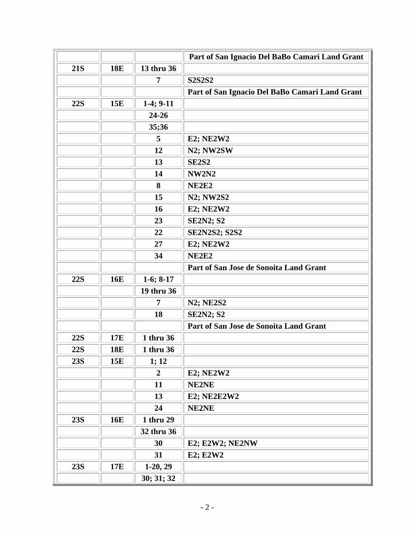
Part of San Ignacio Del BaBo Camari Land Grant 21S 18E 13 thru 36
7 S2S2S2 Part of San Ignacio Del BaBo Camari Land Grant
22S 15E 1-4; 9-11 24-26 35;36 5 E2; NE2W2 12 N2; NW2SW 13 SE2S2 14 NW2N2 8 NE2E2 15 N2; NW2S2 16 E2; NE2W2 23 SE2N2; S2 22 SE2N2S2; S2S2 27 E2; NE2W2 34 NE2E2 Part of San Jose de Sonoita Land Grant
22S 16E 1-6; 8-17 19 thru 36 7 N2; NE2S2 18 SE2N2; S2 Part of San Jose de Sonoita Land Grant
22S 17E 1 thru 36 22S 18E 1 thru 36 23S 15E 1; 12
2 E2; NE2W2 11 NE2NE 13 E2; NE2E2W2 24 NE2NE
23S 16E 1 thru 29 32 thru 36 30 E2; E2W2; NE2NW 31 E2; E2W2
23S 17E 1-20, 29 30; 31; 32
- 2 -

- 3 -
Part of the San Rafael De La Zanja Land Grant 23S 18E 1 thru 18
20 thru 29 32 thru 36 Part of the San Rafael De La Zanja Land Grant
24S 16E 1-5; 8-17 6 E2; E2W2 7 E2; E2W2 18 E2; E2W2
24S 17E 5 thru 24 Part of the San Rafael De La Zanja Land Grant
24S 18E 1-5; 7-24 Part of the San Rafael De La Zanja Land Grant