land use change research projects in...
TRANSCRIPT

Land Use Change Research Projects in Malaysia
Mastura MahmudEarth Observation Centre
Universiti Kebangsaan Malaysia
NASA-LCLUC Science Team Joint Meeting with MAIRS, GOFC-GOLD and SEA START Programs on Land-Cover/Land-Use Change Processes in Monsoon Asia Region, January 12-17, 2009 in Khon Kaen, Thailand

Outline of presentation
• Large Development Regions• Landslide Issues• Biomass Burning and Impacts
South Johor Development Area• Iskandar Malaysia covers 221,634.1
hectares (2,216.3 km²) of land area within the southern most part of Johor.
• The development region encompasses an area about 3 times the size of Singapore.
• Iskandar Malaysia covers the entire district of Johor Bahru (including the island within the district), Mukim Jeram Batu, Mukim Sungai Karang, Mukim Serkat, and Kukup Island in Mukim Ayer Masin, all within the district of Pontian.
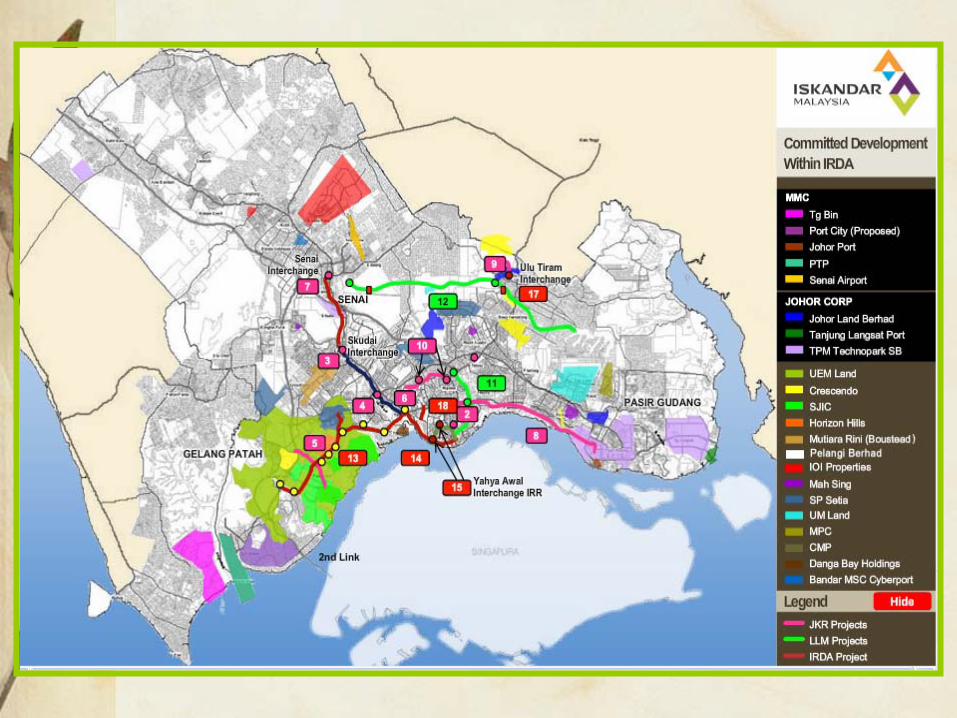

• Five Flagship Zones are proposed as key focal points for developments in the Iskandar Malaysia. Four of the focal points will be located in the Nusajaya-Johor Bahru-Pasir Gudang corridor (Special Economic Corridor -(SEC)). The flagship zones would strengthen further existing economic clusters as well as to diversify and develop targeted growth factors.
• Flagship Zone A – Johor Bahru City Centre(New financial district , Central business district , Danga Bay integrated waterfront city , Tebrau Plentong mixed development , Causeway (Malaysia/Singapore)
• Flagship Zone B - Nusajaya (Johor state administrative centre , Medical hub , Educity , International destination resort , Southern Industrial logistic cluster )
• Flagship Zone C - Western Gate Development (Port of Tanjung Pelepas , 2nd Link (Malaysia/Singapore) , Free Trade Zone , RAMSAR World Heritage Park , Tanjung Piai )
• Flagship Zone D - Eastern Gate Development ( Pasir Gudang Port and industrial zone , Tanjung Langsat Port , Tanjung Langsat Technology Park, Kim-Kim regional distribution centre ).
• Flagship Zone E - Senai-Skudai ( Senai International Airport , Senai cargo hub , Skudai knowledge hub , Senai multimodal , entre , MSC Cyberport city

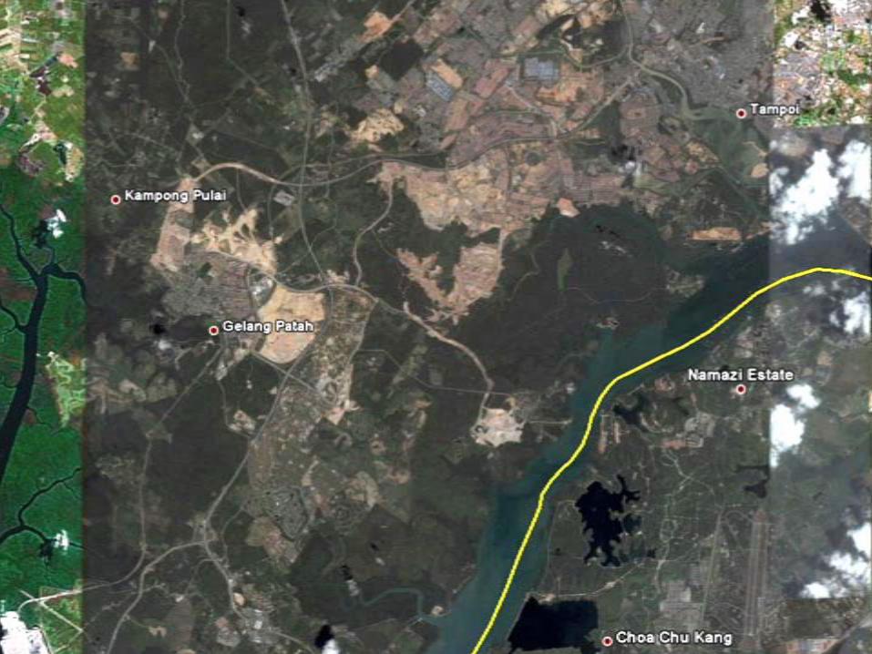
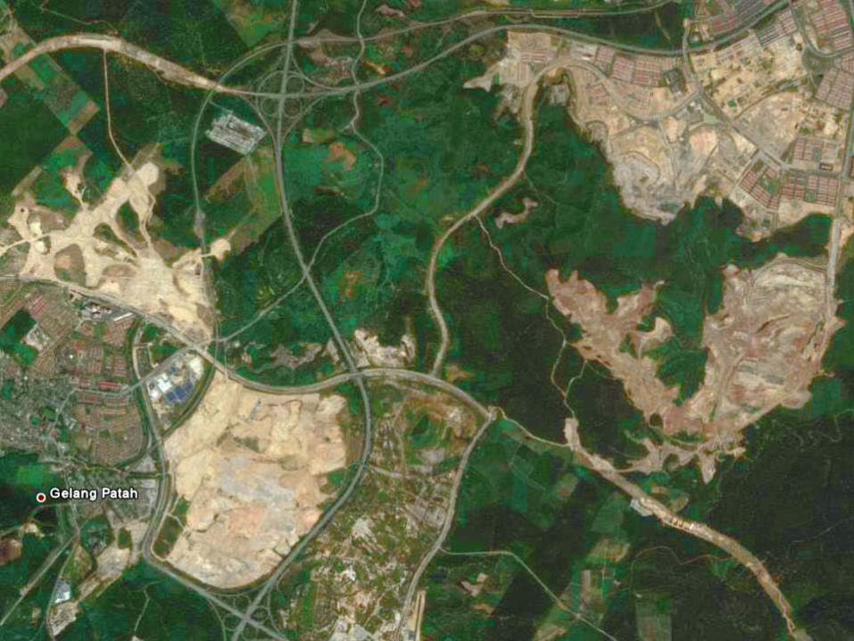
Deforestation Issues• Nusajaya Project (23,875 acres)• 7000 acres of the presently oil palm
and rubber plantations will be cleared to make way for the development plans.
• One of the EOC’s (UKM) project is to calculate the carbon loss from the clearing of the palm oil/rubber plantations.

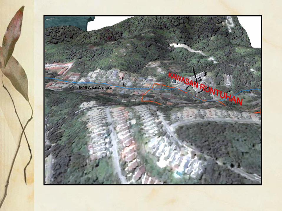
Impacts of Development: Landslide


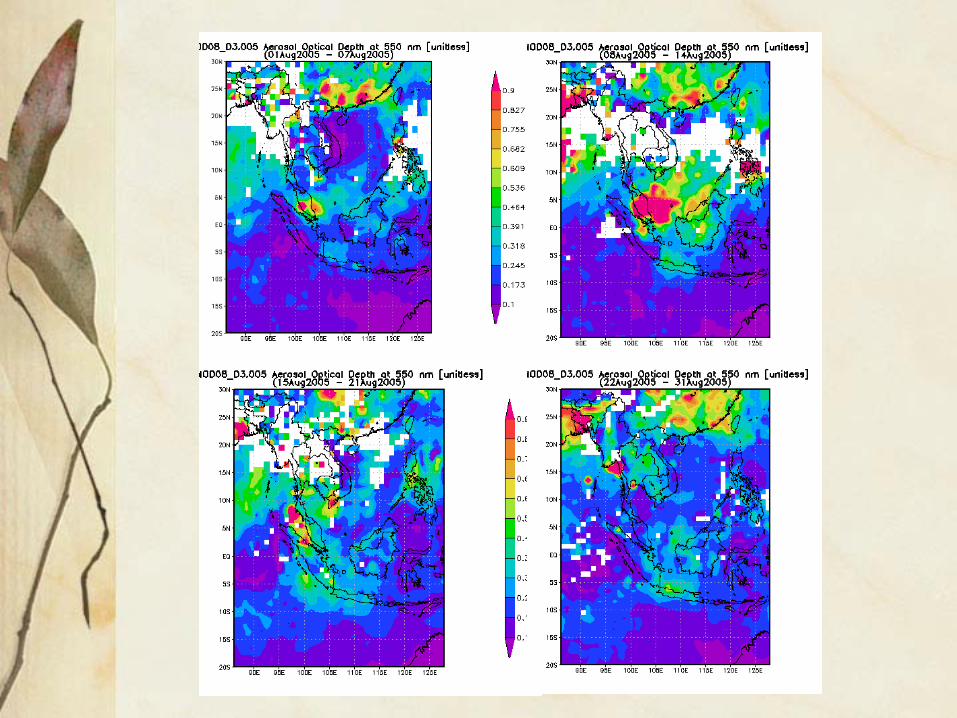
A Study on the Main Contributors of the Transboundary Haze in Peninsular Malaysia in August 2005

Background• The haze emergency state declared on 11 August
2005 in the districts of Klang and Kuala Selangor was one of the worst haze episode that occurred in Peninsular Malaysia since the past decade.
• The unprecedented event of the haze that can be considered an environmental disaster where the air pollutant index indicated hazardous levels of air quality that is harmful to the health of the public.
• The main contributors of the haze that affected the state of Selangor, which was mainly instigated by the vegetation fires in Riau, Sumatera during the height of the burning activities will be the topic of this presentation.

Outline of presentation
• Satellite data of hotspots• Spatial analysis distribution of the
active fire counts• Trajectory analysis• Air quality analysis• Dispersion analysis

MODIS
Hotspots
in
August
2005

MODIS AQUA10 Ogos 2005
Smoke plumesfrom Sumatra

Daily Hotspots in Sumatra
0
200
400
600
800
1000
1200
2005
-08-01
2005
-08-03
2005
-08-05
2005
-08-07
2005
-08-09
2005
-08-11
2005
-08-13
2005
-08-15
2005
-08-17
2005
-08-19
2005
-08-21
2005
-08-23
2005
-08-25
2005
-08-28
2005
-08-30
AquaTerraNOAA
Terra
Aqua
NOAA

AQUA

Total Hotspots in August 2005
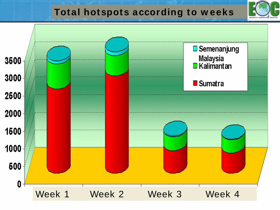
Total hotspots according to weeks
Week 1 Week 2 Week 3 Week 4

A

RIAU
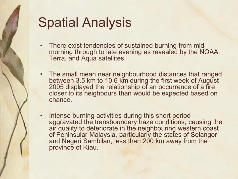
Spatial Analysis• There exist tendencies of sustained burning from mid-
morning through to late evening as revealed by the NOAA, Terra, and Aqua satellites.
• The small mean near neighbourhood distances that ranged between 3.5 km to 10.6 km during the first week of August 2005 displayed the relationship of an occurrence of a fire closer to its neighbours than would be expected based on chance.
• Intense burning activities during this short period aggravated the transboundary haze conditions, causing the air quality to deteriorate in the neighbouring western coast of Peninsular Malaysia, particularly the states of Selangor and Negeri Sembilan, less than 200 km away from the province of Riau.

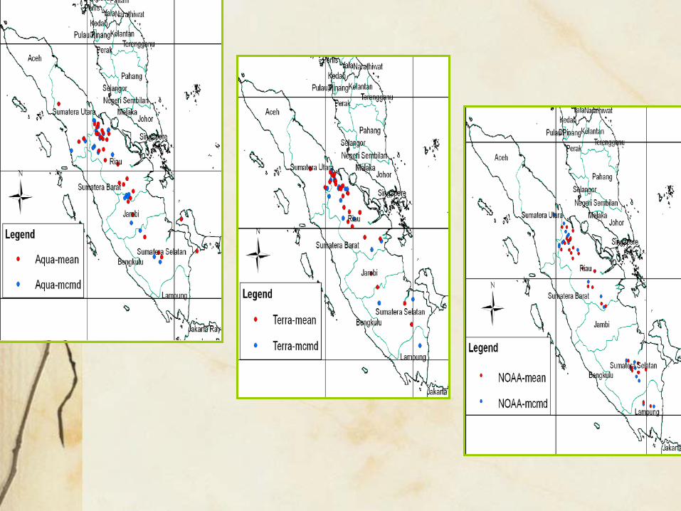
Centrographic analysis
Daily Mean Centre
Red: Aqua, Green: Terra,
Blue: NOAA

Vegetation Types in Sumatra, August 2005
0
200
400
600
800
1000
1200
1400
1600
Aceh Bengkulu Jambi Lampung Riau SumateraBarat
SumateraSelatan
SumateraUtara
Num
bers
of H
otsp
ots
Evergreen ForestDegraded ForestPaddy FieldPeat ForestFarmlandGrasslandMangrovePine ForestSwamplandTropical Mountainous Forest
Emissions Analysis• Biomass burning emissions in Sumatera released a
significant source of greenhouse gas such as carbon dioxide (CO2) and methane, as well as ozone precursors such as non-methane hydrocarbons and nitrogen dioxides (NOx).
• Total emissions of methane, CO, CO 2, NOx, particulate matters and a suite of other gases from biomass burning were emitted from forests, degraded forests, peat land areas and agricultural waste burning.
• The combination of greenhouse gases, smoke particulates and hazardous gases in the transboundary haze is of concern especially to the neighbouring countries that are directly affected due to their close proximity to the source of the burning.

Estimates of pollutants from Sumatera during August 2005
Total

Trajectory Analysis
• The topographical setting of the landform that encompasses the Sumatera Island and Peninsular Malaysia is one of the factors that disfavour efficient dispersion and diffusion of pollutants during the haze episodes.
• The air trajectories showed evidence that the air was near-stagnant during the first two weeks of the month of August 2005.

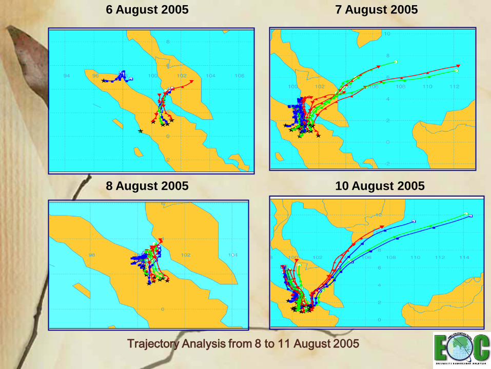
Trajectory Analysis from 8 to 11 August 2005
6 August 2005 7 August 2005
8 August 2005 10 August 2005

AIR QUALITY ANALYSIS• The Malaysian Air Pollutant Index (MAPI)
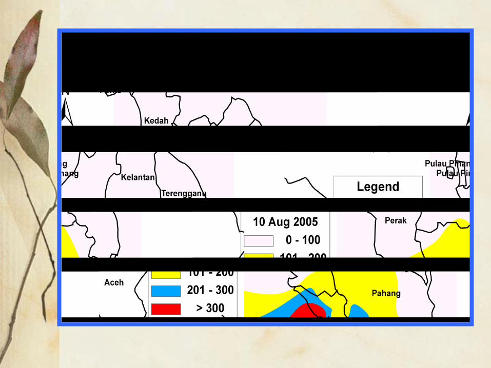
exceeded the 300 levels during the early morning of 10 August 2005 in the districts of Klang and Kuala Selangor. The air quality then improved when the MAPI levels reached below 300 by midday of 12 August 2005.
• This period coincided with the intense burning activities concentrated in the provinces of northern Riau and southern Sumatera Utara. The correlation between the hotspots in Riau and the PM10 concentrations recorded in the Raja Zarina School in Klang was moderate at 0.7.

The MAPIHourly MAPI, 1 to 13 August 2005
0
100
200
300
400
500
600
1 2 3 4 5 6 7 8 9 10 11 12 13 14 15 16 17 18 19 20 21 22 23 24
Hours
Mal
aysi
an A
PI1-Aug-05
2-Aug-05
3-Aug-05
4-Aug-05
5-Aug-05
6-Aug-05
7-Aug-05
8-Aug-05
9-Aug-05
10-Aug-05
11-Aug-05
12-Aug-05
13-Aug-05

Daily MAPI and PM10concentrations
Daily MAPI and PM10 values
0
100
200
300
400
500
600
700
1-Aug
3-Aug
5-Aug
7-Aug
9-Aug
11-Aug
13-Aug
15-Aug
17-Aug
19-Aug
21-Aug
23-Aug
25-Aug
27-Aug
29-Aug
31-Aug
MA
PI
0
100
200
300
400
500
600
700
PM10
( µg/
m3 )
PM10RMAQMAPI

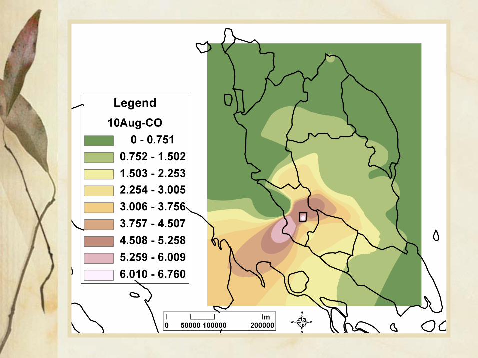

Dispersion Analysis• The transboundary processes from vegetation burning
sources from Sumatera two days prior to the haze emergency period declared in the districts of Klang and Kuala Selangor were successfully simulated in this study.
• Most of the plumes from Riau were directed northeastward by the weak southwesterly monsoon towards the neighbouring states of Selangor.
• Smoke plumes that were generated within 24 hours after emission was by and large a local phenomenon, when the plumes were confined near the locations of burning in Riau.
• Within 36 to 48 hours, the plumes were generally found over the western coast of Peninsular Malaysia, particularly affecting the southwestern half of the Peninsular Malaysia such as Selangor, Pahang, Negeri Sembilan and Melaka.

The dispersion analysis, which shows the merging of several puffs after a period of 48 hours from integration on 11 August 2005. AQUA.
CONCLUSION• The recurrence of the large-scale biogenic fires
and the resulted transboundary haze is one of the most serious environmental issues facing Southeast Asia today.
• Fires are deliberately set alight to clear forests and land, particularly in Indonesia over the last few decades which had led to repeated air pollution episodes within the neighbouring countries such as Malaysia, Singapore and Brunei.
• Clearly the transboundary haze problem must be solved and controlled to cope with the negative impacts it brings to the population of the neighbouring countries.

Terima KasihThank You