land tenure dynamics in peri-urban zambia · peri-urban areas are transitional zones between urban...
TRANSCRIPT

USAID.GOV LAND TENURE DYNAMICS IN PERI-URBAN ZAMBIA BRIEF 1
USAID TGCC PROGRAM
LAND TENURE DYNAMICS IN PERI-URBAN ZAMBIA POLICY BRIEF
EXECUTIVE SUMMARY
Peri-urban growth in Zambia faces particular challenges due to the interface of state and customary land administration systems with different stakeholders using land under leasehold and customary tenure regimes. The lack of structures to document these landholdings, share information, or resolve disputes between state and customary institutions presents risks to realizing sustainable development in peri-urban areas. This brief presents recent illustrations based on news media accounts of customary and state institutional overlap, planning and service delivery gaps, conversion of customary to leasehold land tenure, risks to public lands, and an inadequate land information system each of which contributes to peri-urban tenure insecurity. It concludes by identifying opportunities for protecting the rights of peri-urban customary smallholders and new urban settlers, promoting economic growth, reducing conflict, and improving resource management through the following four areas of work and twelve actions/recommendations, many of which are already conceptualized by the Government of the Republic of Zambia, but require additional support to be realized. These recommendations include:
Establish the current status of peri-urban land by: 1) developing an empirical understanding of peri-urban land tenure dynamics through targeted research; and, 2) documenting and making accessible state and customary land tenure information.
Recognize and protect existing rights by: 1) strengthening the recognition of the rights of existing peri-urban smallholders and residents of informal settlement; 2) protecting remaining public lands in peri-urban areas; and, 3) upgrading and planning informal settlements.
Respect and build on the technical capacities of government and the local legitimacy of customary institutions to improve rural/urban land governance by: 1) clarifying the role of chiefs in customary land under statutory tenure; 2) developing improved guidelines for consultation and consent around land conversion; 3) creating communication channels among councils and traditional leaders on land management; and, 4) developing and training local land tribunals composed of government and customary authorities.
Develop a Land Policy and associated legislation that integrate land administration and land use planning by: 1) ensuring the Land Policy addresses the issue of land rights in peri-urban
USAID.GOV LAND TENURE DYNAMICS IN PERI-URBAN ZAMBIA BRIEF 2
areas; 2) designing legislation that can address challenges at the urban/rural interface; and, 3) bringing peri-urban and rural areas into the national planning process, while respecting the roles of all stakeholders and legitimate leaders.
1.0 URBANIZATION, LAND TENURE, AND ZAMBIA’S DEVELOPMENT AGENDA
This brief examines the dynamics of peri-urban development and land tenure systems in Zambia. It considers issues that face cities, like Lusaka, Kitwe, and Ndola, as well as issues found in district municipalities that act as micro-urban hubs across the country. Due to the lack of published articles on land tenure issues in Zambia’s cities and municipalities and its current dynamism, the brief relies largely on current events from the news and case studies to illustrate issues and present a series of recommendations for moving forward. The brief presents background on the Zambian peri-urban land tenure context, describes a series of tenure issues and their relationship to urban/peri-urban development, and summarizes opportunities for no-regrets action and deeper analysis. Key issues documented in this brief include: institutional overlap that creates land tenure ambiguities; land use planning and service delivery dynamics in peri-urban areas; conversion of customary land to leasehold tenure and associated issues of consultation, displacement, and compensation; vulnerability of natural resources; and weak customary and state land administration systems.
A defining feature of the 21st century is the process of urbanization, with current urban growth rates exceeding 3.5 percent per annum in many countries. High urbanization and high population growth put a strain on urban infrastructure such as water and sanitation, roads and transport, energy, and housing. Increasing demand for land and competition among different groups, including farmers, herders, informal settlers, urban elites, and foreign investors can result in social tension and in some cases outright conflict (Cotula, Toulmin, & Hesse, 2004). Despite being perceived as a rural continent, African countries face these same land challenges in and around their urban areas. While Zambia is a land abundant country, 40 percent of its population of 17 million people reside in urban areas, and its total population continues to grow at 2.9% annually. This makes Zambia one of sub-Saharan Africa’s most urbanized countries (United Nations, Department of Economic and Social Affairs, 2014). Zambia’s cities include provincial capitals, mining centers, and district municipalities, all of which act as draws for the rural poor.
Zambia’s ambitious development goals in its Vision 2030 and Seventh National Development Strategy of becoming a middle income nation by 2030 can only be achieved through economic growth in these urban and peri-urban areas (Ministry of Finance, 2017). A central element of reaching these goals will be to clarify and improve the complex land administration and land management issues plaguing the country, particularly in urban and peri-urban areas, to unlock an active land market for investment and growth, while protecting the rights of local communities and poor and vulnerable populations.
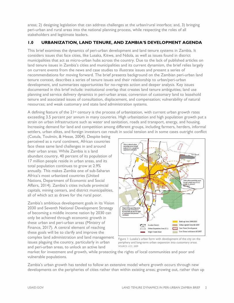
Zambia’s urban growth has tended to follow an extensive model where growth occurs through new developments on the peripheries of cities rather than within existing areas; growing out, rather than up
Figure 1: Lusaka’s urban form with development of the city on the periphery and long-term urban expansion into customary areas SOURCE: LCC, 2009

USAID.GOV LAND TENURE DYNAMICS IN PERI-URBAN ZAMBIA BRIEF 3
(Figure 1). Within Zambia, urban/peri-urban development is not constrained by a lack of land, but rather a dual land tenure system that is perhaps most complicated in these high value, high demand areas where traditional customary land tenure systems interact with government managed state systems.
2.0 LAND TENURE CONTEXT IN PERI-URBAN ZAMBIA
Peri-urban areas are transitional zones between urban and rural areas with no particular distinction in boundary. Iaquinta and Drescher (2000) consider a peri-urban area to be a non-smooth, multidimensional continuum, defined not by specific proximity to a city, but rather the intensification of life and activities in an area. As a result, it is very difficult to determine a fixed boundary between urban and rural.
Zambia’s peri-urban land largely sits at the interface of statutory and customary land tenure systems1. The colonial legacy of the tenure system in Zambia, as in many sub-Saharan African countries, is a dual land tenure system comprising one part statutory tenure and the other part customary tenure. Statutory tenure is by way of leasehold without freehold and administered by government through the Ministry of Lands and Natural Resources (MLNR) and its agents (district/city councils), while customary tenure is governed by customary norms and administered by traditional leaders, through a chief and village headman structure that typically lacks formal documentation. State land is largely restricted to urban areas, district municipalities, commercial farmland along the railroad line, the mining areas of the Copperbelt, and pockets of large commercial farms. At independence, state land represented only 6 percent of the country. However, since 1995 with the emergence of the Lands Act (cap 184) that allows for conversion of land out of customary tenure, a significant, but unknown, portion of customary land has been converted to statutory tenure both by individuals and the state (Figure 2). Customary tenure maintains certain restrictions that have been said to limit development and complicate transparency in land administration; for example, land in customary tenure cannot be legally bought, sold, or traded, and traditional leaders have a large degree of autonomy on displacing occupiers of land.
1 Customary areas are defined in the Lands Act, No 20 of 1995 as trust land and reserves as established in colonial orders. Statutory tenure is mainly practiced on what is called “state land,” which is defined in the same Act as “land which is not situated in a customary area.” Under the Lands Act, customary areas can be brought under statutory leasehold tenure through a conversion process described in this brief. Some of the customary areas contain public land (not an official land category), where the state has management responsibilities on customary areas; for example, protected areas and national forests. This brief refrains from quoting commonly cited figures of 94 percent customary vs. 6 percent state land, or 70 percent customary tenure vs. 30 percent statutory tenure, both of which may be realistic estimates, but describe different dynamics. Some academics argue that once customary areas are brought under leasehold tenure, they cease to be customary areas, while others, including government, argue that the land is statutory leasehold tenure on customary land.
Figure 2: State and customary land as prescribed at independence and in the 1995 Land Act (cap 184).
USAID.GOV LAND TENURE DYNAMICS IN PERI-URBAN ZAMBIA BRIEF 4
Many of Zambia’s “urban” areas are also relicts of colonial practices, where small district centers were reserved for a relatively small number of colonial settlers. For example, up until 1972, Lundazi town was officially restricted to a 1.5km radius, an area that is much too small to accommodate the district’s urban needs (Kalapula & Nchito, 2017). In all of Zambia’s cities, individuals have moved to the customary peripheries, seeking available land that has historically been transacted through non-market value exchanges among customary residents with consent of traditional leaders. In some cases new settlers fully or partially convert land to statutory tenure, while in others they develop housing or plots on land under customary tenure. As a result, the dynamics of peri-urban growth varies in Zambia depending on the following four tenure regimes:
• State land under statutory tenure: Here the district or city council has a large degree of influence in the allocation, management, and planning of this land. These lands are already largely occupied and developed, though in many cases they are not fully planned or serviced. These areas have particular tenure challenges related to dense, low-income informal settlements, where poor urban settlers illegally occupy state land but with no documentation. In many cases neither the occupants nor government know the clear boundaries of the settlement.
• Customary land under customary tenure: These lands are under the authority of the chiefs with responsibilities devolved to village headpersons for management of land. A chief’s subjects and their families have long-term, largely undocumented, use rights to the land. Historically these households have been primarily involved in smallholder agriculture. Increasingly in the peri-urban areas, outsiders, often urban elite, acquire this land from traditional authorities either for housing or weekend farms. Due to the illegality of land markets on customary land, any monetary transactions for this land is technically illegal, but nevertheless, a very common practice. These outsiders may or may not then seek to convert customary land to statutory tenure (see below). Occupiers of customary land do not pay ground tax to government, and community members are vulnerable to being displaced by outside investments. Community members may pay tribute to traditional ceremonies, however these customary taxes are not necessarily related to the number or size of landholdings of households.
• Customary land converted to statutory tenure by individuals: In this case individuals (or companies) convert isolated pockets of customary land to leasehold tenure for farming, residential or commercial uses. Following approval from the chief and the district council, landholders may acquire and convert customary land under customary tenure to statutory tenure. Due to the autonomy of chiefs and village headpersons and a lack of customary land governance guidance, some villages or chiefdoms have been heavily converted while others remain entirely customary. These conversions have largely been to outsiders and not to the original smallholder occupiers of the particular chiefdom, as was the written intention of the 1995 Lands Act. While the conversion process results in documented and regularized tenure, it poses challenges to urban planning and is prone to overlapping or missing records. Some have accused traditional leaders of using this process to sell off customary land, while others note that the alternative is a ‘forced’ government conversion (described below).
• Customary land converted to statutory tenure by government: As urban areas grow, and councils aim to promote investment and provide services or revenue from ground rents, the government may expand a municipal or city boundary through negotiations with one or more chiefs. These conversions tend to be based on extending an existing boundary by a number of kilometers. As a result, these extensions encompass customary communities, as well as the individual conversions that have occurred over time. From a tenure security perspective, existing residents may not have an opportunity to formalize their rights and the subsequent government allocation of plots has been prone to allegations of corruption.

USAID.GOV LAND TENURE DYNAMICS IN PERI-URBAN ZAMBIA BRIEF 5
Additionally, these areas may not have an immediate use, putting original occupants into a state of legal limbo as their customary rights are extinguished, but leasehold rights are not immediately recognized. Theoretically, these areas could be formalized under leasehold with the original smallholder residents, but councils are reluctant to do this, as their land acquisition goals are often associated with developing urban infrastructure and services that are out of reach to these smallholders.
Each of these tenure regimes poses challenging conditions for peri-urban development because community members, traditional leaders, new settlers, and government have different rights and responsibilities (and vulnerabilities) depending on their status on this land (Figure 3).
3.0 KEY LAND TENURE ISSUES IN PERI-URBAN AREAS
The following section reviews constraints on peri-urban development posed by Zambia’s land administration and management structures.
3.1 INSTITUTIONAL OVERLAP
Relationships between traditional authorities and the government, as well as among government institutions with land management responsibilities, create conditions of confusion and ambiguities where people may perceive their rights as secure, when in fact they are at risk.
3.1.1 CUSTOMARY LEADERSHIP AND GOVERNMENT/COUNCILS
The lack of transparency, communication, and coordination between traditional leaders and the government on land rights at the interface of state and customary land is a major source of tenure insecurity on both customary land and unplanned state land. While many countries in Africa retained customary land and traditional leaders post-independence, Zambia placed a large degree of autonomy and authority onto these traditional leaders to administer land. Zambia’s 288 chiefdoms cover approximately 94 percent of the country. Yet the role of the chief on customary land that has been converted to statutory tenure remains ambiguous at best. Chiefs continue to have roles with
Figure 3: Diagram of modes of expansion of urban areas into state and customary land and associated risks when land is converted.
Figure 4: Government and chiefs have a contentious relation over land, as politicians need chiefs’ support for votes, but once in power politicians need land to advance their economic development objectives through conversion of smallholder agricultural lands to other more profitable uses. SOURCE: Daily Nation, 3 February 2017.

USAID.GOV LAND TENURE DYNAMICS IN PERI-URBAN ZAMBIA BRIEF 6
respect to law enforcement and traditional court cases in converted areas, but in practice their influence is significantly less on leasehold landholders, particularly as leaseholders put up fences and go against customary practices by excluding dry season grazing of livestock. Chiefs and government have few mechanisms to coordinate and communicate; for example, where there is a boundary dispute between a leasehold title holder and a customary subsistence farmer (Figure 4). Even during the process of converting land from customary tenure there is limited communication between chiefs and the government. Technically, land conversions require the signature of the chief (on behalf of local communities), the district council, and the Commissioner of Lands. However, the filing of this information is done solely by the landholder and as a result there is not a mechanism for coordination among these key institutions over individual land conversions. The resulting disputes relate to unclear boundaries, lack of consultations, and the displacement of smallholders whom the chief may subsequently be responsible for resettling.
3.1.2 MINISTRY OF LANDS AND NATURAL RESOURCES AND LOCAL COUNCIL RELATIONSHIPS
Both the Ministry of Lands and Natural Resources and local councils have land management responsibilities and mechanisms to secure tenure. This results in duplication of efforts and a preference of many landholders to only interact with the local councils. Land administration in the country is governed by MLNR through the Commissioner of Lands under the Lands Act of 1995. All land in municipal areas is state land and as such falls under the administration of the Commissioner of Lands. To create efficiencies in land administration, however, the MLNR awards land agency licenses to city and district councils to alienate and administer land on its behalf. This is done through the Land Circular of 1985 which was promulgated to give guidance on how land should be alienated. In the recent past (June 2017), the MLNR has had to withdraw licenses from the Ndola City Council and the Kabwe District Council for alleged illegal land dealings (Zambia Daily Mail, June 2017). Ground rents are a significant source of council revenue (over 50 percent of self-generated revenue). In some districts elected officials are given a portion of all new land developed and planned under their authority, as a form of payment. These dynamics, along with a massive demand for plots, encourage councils to open up new areas, receive application fees for plots and subsequently allocate land through relatively non-transparent processes (Figure 5). At the same time, land allocation in peri-urban areas is fraught with political patronage. Often members of the ruling party are promised a piece of land. Political cadres have been known to subdivide, “survey,” and “allocate” land in the periphery of cities due to the shortage of land in cities and towns (see for example, Chitonge & Mfune 2015).
Land falling within statutory and improvement areas is administered by the councils using Urban and Regional Planning Act of 2015 (URPA), and previously the Housing (Statutory and Improvement Areas) Act of 1975. The councils in these areas hold the head lease from government and issue council Certificates of Title (for statutory areas) through the Ministry of Lands (though some reports indicated that the head lease is no longer in use). Councils also have the ability to offer 30 year occupancy licenses (for Improvement Areas), which are not recorded by the MLNR. The use of occupancy licenses administered exclusively by the council creates a parallel tenure system to the Ministry of Lands and
Figure 5: Corruption allegations around land allocation processes result in revoking of local council rights SOURCE: Daily Mail, 9 June 2017; Daily Nation, November 2016
USAID.GOV LAND TENURE DYNAMICS IN PERI-URBAN ZAMBIA BRIEF 7
caused confusion for local residents over their long-term rights. The local councils undoubtedly hold a more complete set of land information than the MLNR within individual council areas but often they lack the municipal boundary maps to know their full area of responsibility.
3.2 PLANNING FRAMEWORK AND SERVICE DELIVERY
With a range of residential, commercial, and industrial demands for peri-urban land, the benefits of planning for service delivery are clear. However, the slow process of government planning cannot keep up with the pace of demand, and many investors/developers find that going through ad hoc acquisition of customary land is quicker and cheaper than waiting for district council or MLNR processes to plan land for development in peri-urban areas.
3.2.1 COMPETING LAND USES AT THE PERI-URBAN FRINGE
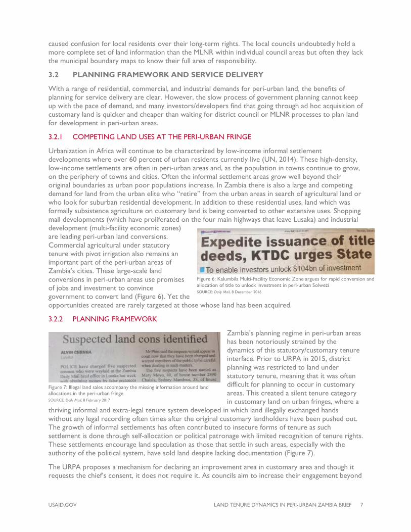
Urbanization in Africa will continue to be characterized by low-income informal settlement developments where over 60 percent of urban residents currently live (UN, 2014). These high-density, low-income settlements are often in peri-urban areas and, as the population in towns continue to grow, on the periphery of towns and cities. Often the informal settlement areas grow well beyond their original boundaries as urban poor populations increase. In Zambia there is also a large and competing demand for land from the urban elite who “retire” from the urban areas in search of agricultural land or who look for suburban residential development. In addition to these residential uses, land which was formally subsistence agriculture on customary land is being converted to other extensive uses. Shopping mall developments (which have proliferated on the four main highways that leave Lusaka) and industrial development (multi-facility economic zones) are leading peri-urban land conversions. Commercial agricultural under statutory tenure with pivot irrigation also remains an important part of the peri-urban areas of Zambia’s cities. These large-scale land conversions in peri-urban areas use promises of jobs and investment to convince government to convert land (Figure 6). Yet the opportunities created are rarely targeted at those whose land has been acquired.
3.2.2 PLANNING FRAMEWORK
Zambia’s planning regime in peri-urban areas has been notoriously strained by the dynamics of this statutory/customary tenure interface. Prior to URPA in 2015, district planning was restricted to land under statutory tenure, meaning that it was often difficult for planning to occur in customary areas. This created a silent tenure category in customary land on urban fringes, where a
thriving informal and extra-legal tenure system developed in which land illegally exchanged hands without any legal recording often times after the original customary landholders have been pushed out. The growth of informal settlements has often contributed to insecure forms of tenure as such settlement is done through self-allocation or political patronage with limited recognition of tenure rights. These settlements encourage land speculation as those that settle in such areas, especially with the authority of the political system, have sold land despite lacking documentation (Figure 7).
The URPA proposes a mechanism for declaring an improvement area in customary area and though it requests the chief’s consent, it does not require it. As councils aim to increase their engagement beyond
Figure 6: Kalumbila Multi-Facility Economic Zone argues for rapid conversion and allocation of title to unlock investment in peri-urban Solwezi SOURCE: Daily Mail, 8 December 2016
Figure 7: Illegal land sales accompany the missing information around land allocations in the peri-urban fringe SOURCE: Daily Mail, 8 February 2017

USAID.GOV LAND TENURE DYNAMICS IN PERI-URBAN ZAMBIA BRIEF 8
the borders of the municipalities, district planners are expected to open up new improvement areas in customary land, preferably through consultation with the chiefs. These areas offer the benefit of planned areas for service delivery and will remain under customary administration. There is an economic, social, and environmental interdependence between rural and urban areas and a need for a balanced and mutually supportive approach to the development of the two areas (FIG, 2004), though it remains to be seen whether the current framework will adequately protect the poor inhabitants of peri-urban areas. There is some concern that the current approach allows the government and elites to acquire land through legal and extra-legal approaches with limited to no compensation to customary landholders or
current occupants (Figure 8).
3.2.3 SERVICE DELIVERY
The Government of Zambia, in its seventh National Development Plan (Ministry of Finance, 2017), acknowledges the underdevelopment of rural areas and attributes this to several factors, including the highly centralized system of service delivery, which tends to disadvantage the rural areas. Lusaka has had its share of urban sprawl as most of the new areas are being developed towards the periphery of the city. The current lack of clear tenure systems and historical planning approaches in the customary/leasehold tenure overlap creates significant challenges to service delivery reaching these areas.
The government may wish to deliver services to new areas on the outskirts of the city. Yet, due to ad hoc rather than planned urban expansion, these efforts tend to be upgrading informal settlements or introducing services to suburban homesteads that have already invested in being self-sufficient for water and sanitation, and in some cases electricity. This after-the-fact approach is more costly than the pre-planned approach due to retrofitting and impacts on existing development. In some cases, government extension of services is rejected by local residents, as households resist paying for city water after they have invested in private boreholes, or fear the impacts of top-down planning on existing infrastructure
Figure 9: President Lungu fights against settling of land that interferes with service delivery. SOURCE: Daily Mail, 25 November 2016
Figure 8: Kitwe City Council realized that it cannot demolish houses, noting that the issue arose due to a lack of proper planning. In contrast, Chingola Council decided to demolish structures on “virgin” land and offer no compensation or assistance to the residents. SOURCE: Times of Zambia, 2 January 2017; Times of Zambia, 20 April 2017

USAID.GOV LAND TENURE DYNAMICS IN PERI-URBAN ZAMBIA BRIEF 9
(Figure 9). Urban sprawl and unplanned development further place a strain on transport systems. All leasehold parcels require road access and the haphazard titling of leasehold land has created challenges in establishing these road networks. Additionally, most work continues to be found in the original urban centers, and in the absence of functioning ring roads, commercial traffic is routed to the city center creating congestion.
3.3 CONVERSION OF LAND TENURE FROM CUSTOMARY TENURE TO STATE LEASEHOLD
Peri-urban land is under pressure to be converted into statutory leasehold tenure. The impacts of land use change and conversion of land to leasehold tenure have not been robustly assessed in Zambia, however a few pieces of research are beginning to create an evidence base. A study by Munshifwa (2017) shows the emergence of a land market in three chiefdoms near cities and towns in Copperbelt Province, highlighting that the individual proclivities of an individual chief are the most influential factors in whether land is converted or remains customary. A study by Malambo (2013) in Chibombo on the outskirts of Lusaka found that while a number of individuals were able to obtain title deeds and establish businesses, such as cooking oil plants, filling stations and lodges, this resulted in a reduction in land holding by original owners and an increase in conflicts over land between the newly formalized inhabitants and former smallholder farmers. Apart from changes in economic factors, the study also identified changes in social relations to land with divides between original holders and new settlers and the loss of group holdings of communal land and family managed plots. This is indicative of a pushing out of original settlers and traditional practices from peri-urban areas (Figure 10). The transition is often justified by the argument that newer settlers will engage in more productive uses of the land; however, evidence from Sitko and Jayne (2014) indicates that these new title holders in peri-urban Zambia do not necessarily make more productive use of their land than the original customary holders. This class of new landholders is better defined as weekend farmers, who have secondary sources of income, rather than emergent farmers, who lead the way toward more productive farming practices.
3.3.1 CONSENT AND CONSULTATION
Peri-urban chiefs are under great pressure to participate in the conversion process, though many are reluctant as they know that once they covert the land to statutory leasehold tenure, their control over who occupies the land and what those individuals do with it is limited. Nevertheless, there is a common refrain that chiefs are becoming corrupt and “selling” land, in part because the processes for consent and consultation associated with land conversions are not always transparent.
Figure 10: Customary farmers are considered squatters after land is titled. SOURCE: Times of Zambia, 25 November 2016
Figure 11: Chieftainess Nkomeshya of Lusaka District is sued by local communities for lack of consultation of land use that infringed on an individual subject’s land; and, President Lungu uses his speech to call for chiefs to stay away from land sales. SOURCE: Daily Nation, 3 February 2017 and 18 March 2017

USAID.GOV LAND TENURE DYNAMICS IN PERI-URBAN ZAMBIA BRIEF 10
The process of conversion of customary to leasehold tenure requires the signature of the local council and the local chief, on behalf of his/her subjects, before being submitted to the Commissioner of Lands for final conversion. Conversions of greater than 250 hectares require the signature of the Minister of Lands, while areas over 1,000 hectares require the approval of the President. According to the Customary Conversion Regulations of 1996, the signature of the chief confirms “that the applicant is not infringing on any other person's rights” and that “I have caused the consultation to be made with members of the community.” Similarly the local authority representative approval implies a check of the chief’s approval with the statement “I am not aware of any other rights personal or communal to the use and occupation of the land or any part of the land.” Despite these prescribed forms, there are no guidelines on how this should happen, and in practice, robust consultation is rare. This process has created an impression that customary leaders can be corrupted when commercial interests and a changing economy meet traditional structures (FAO, 2007) (Figure 11).
While Zambia has a Zambia Development Agency and investors are encouraged to first work through the local council, in practice, many first approach a local headperson or chief. Customary land is not permitted to be bought or sold; however, any interaction with the chief involves a “gift,” and there are reports of vehicles or other large gifts being left with chiefs associated with land conversion. It has been observed that chiefs have sometimes appended their signature on site plans which they did not understand, resulting in authorizing more land to be given on title than intended (Kachamba, 2004). The extent of leaseholds on customary land is not entirely clear in the peri-urban chiefdoms or across the country as whole. Across the country, leasehold title is still relatively rare in customary areas, with only 14 percent of chiefs having 10 percent of the farmers in their chiefdoms with leasehold (Table 1). In over 50 percent of all chiefdoms there is no leasehold title observed for farmers. These figures do not, of course, highlight the amount of land that any given leaseholder has, as those with leasehold may be expected to have larger tracts of land than those without.
3.3.2 RIGHTS OF CURRENT OCCUPANTS: COMPENSATION, OBLIGATIONS AND DISPLACEMENT
Insecure tenure and ambiguous governance structures within urban and peri-urban areas result in increased risk of displacement of informal settlers. According to Chu, Young, and Phiri (2015), displacement frequently occurs on customary land areas when land is converted to statutory leasehold and allocated to investors by traditional leaders, local authorities, and the national government. There are no proper compensation mechanisms for resettlement associated with land conversion. The government is empowered and has a right to compulsorily acquire land in the interest of the public, as occurs during municipal expansion. The Lands Acquisition Act CAP 189 stipulates that where a property is acquired by the state, compensation should be paid to the value of the acquired property, or in lieu of payment, a grant of another piece of land may be made with the same value as the land acquired (Section 10). However this only applies to state land. On customary land, compensation may be paid for physical infrastructure / improvements to the land, but not for the market value of the land. Zambia’s Resettlement Policy of 2015 argues for compensation for persons who hold either customary or state land and who are affected by displacement or loss of assets. The policy is silent on whether persons should be compensated for the value of land, though resettlement would be associated with assisting in
Table 1: Percent of smallholders with leasehold title across all chiefdoms
Percent of smallholder leaseholders
Percent of chiefs
0% 51%
0-5% 23% 5-10% 12%
10-25% 10%
25-50% 3%
50-100% 1%
SOURCE: IAPRI, 2015

USAID.GOV LAND TENURE DYNAMICS IN PERI-URBAN ZAMBIA BRIEF 11
identification of suitable land (on leasehold title the resident would be required to pay for surveying fees).
3.3.3 DYNAMICS OF MUNICIPAL EXPANSION VS. AD HOC EXPANSION VS. CREATION OF NEW DISTRICTS
Ad hoc expansion: Given the historical small size of district municipal centers and the low cost of accessing customary land in peri-urban areas since 1995, a large, but unknown, amount of peri-urban land has been acquired through ad hoc acquisition of small parcels by urban elites and property investors. Many of these transactions have reportedly not been fully registered with the Ministry of Lands, due to the bureaucratic process associated with conversion, logistics that require multiple trips to Lusaka or Ndola, and in some cases efforts to avoid paying ground rents. Households reportedly feel adequately secure with the council and chief’s approval. Analysis of Rural Agricultural Livelihoods Survey data from the Indaba Agricultural Policy Research Institute (IAPRI) indicates that around 6 percent of smallholder farmers in the urban provinces of Lusaka and Copperbelt may be in the process of land conversion, much of this around the fringes of existing state land, including peri-urban areas (IAPRI data, 2015). This ad hoc conversion poses challenges as more parcels enter the landscape. For example, in the absence of registered site plans within the Ministry of Lands records, these parcels are subject to overlaps and double allocations with neighbors resulting in costly conflict resolution (Figure 12). Similarly, these dynamics have led to a large market for land speculation. Anecdotal evidence in the peri-urban areas shows that there is a high level of informal sale of customary land, which tends to affect people who may have secondary rights on the land such as the rights to gather firewood.
Municipal expansion: Municipal and city councils often wish to “get ahead” of this ad hoc conversion and undertake mass conversion of peri-urban customary land into statutory tenure that can be allocated by the council. This requires negotiations with the chief, who may be reluctant to undertake mass conversion, either because it may mean that he/she will have to resettle the population currently living on the land into new areas of the chiefdom, or because this will limit livelihood opportunities in the future. This has created awkward municipal boundaries; for example in Lundazi, one of the chiefs has refused to give any land to the council (Figure 13). These dynamics place stress on the relationship between district government and the chiefs, particularly as land is converted and original smallholder settlers are displaced over time with chiefs generally bearing responsibility for relocating these landholders.
Figure 12: Cadastral map of sporadic ad hoc land applications and allocation in Mungule Chiefdom of Lusaka District negatively influencing planning efforts and resulting numerous land use conflicts. SOURCE: MLNR
Figure 13: Extension of municipal boundary of Lundazi town (red) from original 1.5 km radius (black circle), demonstrating lack of successful negotiation with the chief on the western border of town. SOURCE: Kalapula & Nchito, 2017

USAID.GOV LAND TENURE DYNAMICS IN PERI-URBAN ZAMBIA BRIEF 12
New districts: There have been developments in the establishment of new districts in the country ever since the Patriotic Front government came to power in 2011, expanding the number of districts from 72 to the current 110. The creation of new districts has meant that government has had to acquire customary land to create new administrative centers. The extent to which these acquisitions have been compensated for is not clear because most of them are allocated through the chiefs with the promise that development is being brought into the chiefdom. For example, the declaration of Mushindano and Kalumbila as districts of North-Western Province in 2015 preceded the acquisition of customary land by the mining firm, First Quantum Mines. The promise for job creation in these areas does not always result in the actual jobs for locals because the jobs created by the formation of the district might require skills not found in the locally displaced communities. In the newly created Shibiyunji District, the new council has reportedly asked Chief Shakumbila to approve conversion of ~9,000 hectares of land, much of which is already cultivated by local populations (Mwembeshi Nature Conservation Society, Personal Communication). Even if approval is provided, development of the area would take years if not decades to be realized, leaving subsistence farmers displaced from their land based on long-term speculative development of the district center. To address these concerns, as of 2017 the Ministry of Local Government is developing guidance on the establishment of new districts.
3.3.4 INFORMAL SETTLEMENTS ON EXISTING STATE LAND OR PERI-URBAN CUSTOMARY LAND
High-density informal settlements, known locally as “compounds,” are often developed on the periphery of a city. Under the Housing (Statutory and Improvement Areas) Act of 1975, the government was able to declare areas either as housing areas (for areas in which survey standards and planning requirements are minimized and layouts prepared by the councils) or improvement areas (for those areas which were formally illegal). Most of these areas have been informally extended and are no longer within the perimeter of the approved layouts as required by the law. Dense settlements which characterize the areas are prone to environmental and health disasters as often experienced in places like Kanyama and George Compounds in Lusaka, where each rainy season brings floods and illnesses. Despite these difficult conditions, there is a general expectation that land in the periphery will be converted to state land, which will set the stage for leasehold titles to be granted. An example of a speculative informal development that has “paid off” is in Madido, an abandoned former farm, (Figure 14) in which tenure is now being documented and regularized under the pilot project of the National Land Titling Programme. Failure to effectively address informal settlements is due in part to the speed at which migration is taking place and the dynamic nature of this migration in tandem with weak land governance structures at local level, which are limiting planning opportunities.
3.4 NATURAL RESOURCE MANAGEMENT AND LAND USE CHANGE
Natural resources in peri-urban areas are vulnerable due to the demand both for resources and for land. With the growing rates of urbanization in Zambia, land use change is a common feature of peri-urban development, where forest land or wetlands are converted to residential or commercial land. As this occurs, undocumented forest or customary agricultural land is converted into leasehold tenure and former public land, such as forest reserves, is also privatized. The extent of this conversion in Zambia is not known, though there are reports that in the past decade Lusaka has lost over 1/3 of its forest reserves to degazetting and redevelopment (personal communication, Department of Forests). This land is liable to be fenced off to the exclusion of the communities who used to rely on secondary rights to fuelwood, water sources, or other shared resources.
Figure 14: Madido (east of Lusaka) illegal settlement on former farm land.

USAID.GOV LAND TENURE DYNAMICS IN PERI-URBAN ZAMBIA BRIEF 13
Peri-urban forest reserves managed by the Forest Department are generally under pressure as they are perceived by poor populations as open access resources, and by property developers as among the last areas for large scale new commercial or residential development. Kalaba (2017) found in Copperbelt Province (Zambia’s most urbanized province) that state forest reserves were more prone to degradation than customary forests, as they are considered open access as compared to customary land,
which had more local management controls. Increasingly, forest reserves are seen as one of the few places where new large-scale planned investment can take place in peri-urban areas. For example in 2017, there are increasing reports of an active conflict over rapid degazetting of Forest Reserve #27 in Lusaka without public consultation in order to make way for high value properties and industrial development (Statutory Instrument 62 of 2017) (Funga, 2017). Similar degazettement processes occurred associated with the Lusaka South Multi Facility Economic Zone (LS MFEZ), when around 2,100 hectares of land was converted from forest reserve to commercial and industrial use, though pieces of this former reserve were also protected as Lusaka National Park. Chu, Young, and Phiri (2015) noted that 1,221 people were directly affected by the establishment of the LS MFEZ. While the opening up of new large-scale planned areas are often justified through association with national and local development goals, others argue that these efforts undermine important roles of natural spaces for water treatment and erosion control and thus should require longer public consultation and planning periods.
At the same time, government has cited that many of these peri-urban forest reserves have already been encroached by unplanned settlements, with estimates that ~50% of all forest reserves are facing encroachment (cited in National Resettlement Policy). While it can be argued that those who settle illegally on state managed land do not deserve any compensation, the historical context is that most of these forest reserves and other unutilized state public land were previously settled. While some areas still appear as being protected areas on national maps, the reality is often that they contain developed human settlements or have been otherwise degraded (Figure 15).
The dynamics of poor or vulnerable populations occupying ecologically important areas with no formal recognition of their land rights is also commonly seen around rivers, lakes, and low-lying floodplains. In these cases, informal settlers are at risk of eviction in the name of their vulnerability, though the spaces are often subsequently coveted by property developers (Figure 16). In addition to displacements in Zambia’s urban and peri-urban rivers and wetlands, this exclusion of communal access to
water has been seen alongside private sector tourism development, with communities losing access to the Zambezi River in Livingstone and Chirundu and Lake Kariba in Siavonga, which negatively impacts livelihoods (Brown, 2005).
Figure 15: The government considers how to address long-term settlers in forested areas around peri-urban Kitwe. SOURCE: Daily Mail, 10 November 2016
Figure 16: Land allocated by local council in vulnerable area alongside rivers catches the attention of Minister. Later, in June 2017, the land administration responsibility of the two councils was revoked by the Ministry of Lands. SOURCE: Times of Zambia, November 2016

USAID.GOV LAND TENURE DYNAMICS IN PERI-URBAN ZAMBIA BRIEF 14
3.5 LAND INFORMATION IN PERI-URBAN AREAS
Land administration systems document and map people’s tenure rights to parcels of land in different ways. Examples include cadastral maps, land registries, and other forms of land records. The absence of a robust and functioning land administration system for all land in Zambia results in a range of problems at the peri-urban interface of customary and leasehold tenure. Overlapping land allocations, inadequate tools for tracking land transactions, and a loss of revenue for the MLNR and local government result in increased conflict, inefficient service delivery, and poorly planned communities.
3.5.1 OVERLAPPING LAND ALLOCATIONS
It is not uncommon to have the same piece of land allocated to two people due to poor record-keeping by the Ministry of Lands and local authorities. Land records at the local government level, including the City of Lusaka, are kept in paper files. Such records make it difficult to track. At MLNR, cases of double allocation also occur mostly due to re-entry on the basis of lack of development, which result in re-planning and re-allocation of the re-entered land. However, this duplication often leads to contestation in court. Land owners in the urban fringe, especially in Lusaka West, have been affected by land invasions that make it impossible for them to develop their land. Where land is allocated rapidly and infrastructure development lags to mark out the boundaries of plots, overlapping claims are common, as has been frequently observed in Mungule Chiefdom to the north of Lusaka (Figure 17).
3.5.2 INFORMATION SYSTEMS FOR LEASEHOLD AND CUSTOMARY LAND TENURE
In customary areas, there may be limited or no recording of land rights although customary rights are recognized by law through the Lands Act. In many of the country’s councils there are no digital land records, resulting in weak land administration, especially as it pertains to undeveloped peri-urban areas. The Ministry of Lands is developing the Zambia Integrated Land Management Information System (ZILMIS) with the intent to house all land records and improve land administration in the country. However, the system admittedly does not reflect the full status of land on the ground. More than 60 percent of the system’s approximately 500,000 textual records lack associated spatial data, which may or may not be housed in paper form in the Ministry or in local government offices. The lack of a functioning structure to house land data presents a severe constraint to avoid potential land disputes in coveted peri-urban areas. Efforts are underway to consolidate data through the National Land Audit, for example, but the mechanisms to incentivize participation and processes to sort through varying levels of claims and records have not been established.
3.5.3 REVENUE COLLECTION
At the national government level, the land sector does not generate net-positive revenue for the Treasury, though at the local council level, revenue is positive. The government recognizes the need for a robust land information system that will help it achieve its objective of increasing revenue through the land sector. Land revenue cannot be collected if the land is not recorded in the system. Since statutory land is held on leasehold, every leaseholder is expected to pay ground rent to government. Yet one estimate suggests that 70 percent of land in Lusaka is composed of unplanned settlements that do not generate lands revenue (GRZ, 2015).
Figure 17: Community members living on a piece of land titled to a former Member of Parliament are forced to move due to improper record-keeping associated with land conversion. SOURCE: Times of Zambia, 18 November 2016

USAID.GOV LAND TENURE DYNAMICS IN PERI-URBAN ZAMBIA BRIEF 15
There are a number of current challenges to revenue collection, including that: 1) all illegal settlements are not on title and therefore government cannot raise revenue from these; 2) there are a large number of farm properties in peri-urban areas that are in the process of coming into leasehold that also do not currently provide revenue; and, 3) statutory and improvement areas do not pay ground rent despite the fact that this is where the majority of the population lives. In the absence of a functioning land administration system and clear revenue sources from land, the government’s ability to plan for peri-urban areas is limited and councils and the Ministry will continue to be forced to react ineffectively to ad hoc development patterns.
4.0 SUMMARY AND NEXT STEPS TO ADDRESS TENURE INSECURITY IN PERI-URBAN ZAMBIA
The current application of Zambia’s legal framework presents risks to realizing sustainable development in peri-urban areas, as evidenced by the cases presented in this brief. Yet there are real opportunities for protecting the rights of peri-urban customary smallholders, promoting economic growth, reducing conflict, and improving resource management through the following four areas of work and actions/recommendations below, many of which are already underway but require additional support to be realized.
Establish the current status of peri-urban land.
• Develop an empirical understanding of peri-urban land tenure dynamics through targeted research: This brief is based on individual case studies and discussions with experts, but a more complete status of peri-urban land administration and resource management issues is missing. It is not clear whether the reports of corrupt councils and chiefs are the exception or the rule, and only that opportunities exist for these cases to occur within the current legal system.
• Document and make accessible state and customary land tenure information: Systems are necessary at the local government and chiefdom level that feed into a national spatial database to ensure that all records for all forms of tenure are consistent and do not create multiple allocations. The National Spatial Data Infrastructure may be a viable place to house this data through the National Land Audit, particularly if it comes from both government and customary sources. The National Land Titling Program may also generate this information, particularly if it can develop processes that effectively document land under different types of tenure systems, while maintaining a separation between customary and leasehold tenure.
Recognize and protect existing rights.
• Recognize the rights of existing peri-urban smallholders: Regardless of whether leasehold land is acquired through chiefdom conversion to individual investors or through municipal expansion, the rights of smallholders should not be left to the discretion of chiefs, councils and investors. Though the law does not recognize the market value of customary land, as long as the opportunity for ad hoc conversion exists, land speculators will take advantage of these smallholders and traditional authorities. Improvements may be achieved through clear consultation procedures and introducing mechanisms for compensating customary landholders for the market value of the land (as opposed to current compensation that is limited to improvements) rather than encouraging speculators to transition unplanned customary land into leasehold in advance of planning.
• Protect remaining public lands in peri-urban areas: As Zambia’s cities expand through extensive growth, it will be important to protect public lands that provide important ecosystem and social functions, even as their values for other uses increase. This can be achieved through promoting broad public consultation around degazetting of public or protected lands, and to establish a public land category under the Land Policy.
• Upgrade and plan informal settlements: The challenge of planning informal and illegal
USAID.GOV LAND TENURE DYNAMICS IN PERI-URBAN ZAMBIA BRIEF 16
settlements requires consistent but fair application of the law and the establishment of processes to evaluate claims. Though adverse possession is not recognized in Zambian law, local and national government should take responsibility for the lack of enforcement of laws that allowed for illegal settlements to grow. In Zambian cities this will undoubtedly include regularizing the rights of many who are currently illegal occupants.
Respect and build on the technical capacities of government and the local legitimacy of customary institutions to improve rural/urban land governance.
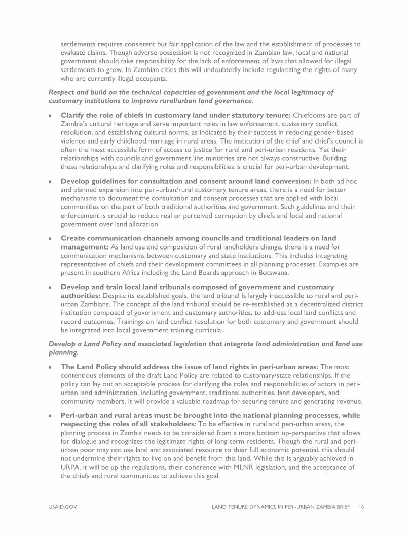
• Clarify the role of chiefs in customary land under statutory tenure: Chiefdoms are part of Zambia’s cultural heritage and serve important roles in law enforcement, customary conflict resolution, and establishing cultural norms, as indicated by their success in reducing gender-based violence and early childhood marriage in rural areas. The institution of the chief and chief’s council is often the most accessible form of access to justice for rural and peri-urban residents. Yet their relationships with councils and government line ministries are not always constructive. Building these relationships and clarifying roles and responsibilities is crucial for peri-urban development.
• Develop guidelines for consultation and consent around land conversion: In both ad hoc and planned expansion into peri-urban/rural customary tenure areas, there is a need for better mechanisms to document the consultation and consent processes that are applied with local communities on the part of both traditional authorities and government. Such guidelines and their enforcement is crucial to reduce real or perceived corruption by chiefs and local and national government over land allocation.
• Create communication channels among councils and traditional leaders on land management: As land use and composition of rural landholders change, there is a need for communication mechanisms between customary and state institutions. This includes integrating representatives of chiefs and their development committees in all planning processes. Examples are present in southern Africa including the Land Boards approach in Botswana.
• Develop and train local land tribunals composed of government and customary authorities: Despite its established goals, the land tribunal is largely inaccessible to rural and peri-urban Zambians. The concept of the land tribunal should be re-established as a decentralized district institution composed of government and customary authorities, to address local land conflicts and record outcomes. Trainings on land conflict resolution for both customary and government should be integrated into local government training curricula.
Develop a Land Policy and associated legislation that integrate land administration and land use planning.
• The Land Policy should address the issue of land rights in peri-urban areas: The most contentious elements of the draft Land Policy are related to customary/state relationships. If the policy can lay out an acceptable process for clarifying the roles and responsibilities of actors in peri-urban land administration, including government, traditional authorities, land developers, and community members, it will provide a valuable roadmap for securing tenure and generating revenue.
• Peri-urban and rural areas must be brought into the national planning processes, while respecting the roles of all stakeholders: To be effective in rural and peri-urban areas, the planning process in Zambia needs to be considered from a more bottom up-perspective that allows for dialogue and recognizes the legitimate rights of long-term residents. Though the rural and peri-urban poor may not use land and associated resource to their full economic potential, this should not undermine their rights to live on and benefit from this land. While this is arguably achieved in URPA, it will be up the regulations, their coherence with MLNR legislation, and the acceptance of the chiefs and rural communities to achieve this goal.

USAID.GOV LAND TENURE DYNAMICS IN PERI-URBAN ZAMBIA BRIEF 17
5.0 BIBLIOGRAPHY
AUC-ECA-AfDB Consortium. (2010). Land policy in Africa: Southern Africa regional assessment.
Brown, T. (2005). Contestation, confusion and corruption: Market-based land reform in Zambia. In Evers, S., Spierenburg, M., & Wels, H., Competing jurisdictions: Settling land claims in Africa. Afrika-Studiecentrum Series. Amsterdam, Holland: University of Amsterdam.
Chitonge, H. & Mfune, O. (2015). The urban land question in Africa: The case of urban land conflicts in the City of Lusaka, 100 years after its founding. Habitat International. Volume 48
Chu, J., Young, K., & Phiri, D. (2015). Large scale land acquisitions, displacement and resettlement in Zambia. PLAAS Policy Brief 41.
Cotula, L., Toulmin, C., & Hesse, C. (2004). Land tenure and administration in Africa: Lessons of experience and emerging issues. London: International Institute for Environment and Development.
FAO. (2007). Good governance in land tenure and administration. FAO Land Tenure Studies Paper 9.
FIG. (2004). Marrakech Declaration: Urban – rural interrelationship for Sustainable development. FIG publication series No 33.
Funga, M. (2017, Sept 21). Chalimbana community rises against govt for encroaching on forest reserve. News Diggers. Retrieved from: https://diggers.news/local/2017/09/21/chalimbana-community-rises-against-govt-for-encroaching-on-forest-reserve/
GRZ. (1996). Section 31: The Lands (Customary Tenure) (Conversion) Regulations. Statutory Instrument 89 of 1996. Lusaka: Government of the Republic of Zambia.
GRZ. (2015). National Resettlement Policy. Lusaka: Office of the Vice President.
Iaquinta, D. L., & Drescher, A. W. (2000). Defining the peri-urban: Rural-urban linkages and institutional connections. Land Reform, Land Settlement and Cooperatives, 2: 8-26.
Indaba Agricultural Policy Research Institute (IAPRI). (2015). Rural Agricultural Livelihood Survey. Available at: http://images.agri-profocus.nl/upload/post/RALS_2015_Survey_Report__Finalv-_edited1456827249.pdf
Kachamba, F. (2004). Innovative development in Zambia – Requirement for a land policy document. Proceedings of an Expert Group Meeting on Secure Land Tenure ‘New Legal Frameworks and Tools.’ Nairobi, Kenya.
Kalaba, F. K. (2017). Land tenure systems and implications for forest carbon management in Zambia’s forest ecosystems. Proceedings of the Research Symposium on Land Management in Zambia. Washington, DC: USAID Tenure and Global Climate Change Program.
Kalapula, M., & Nchito, W. (2017). Dual land tenure and the expansion of small towns: the case of Lundazi town, eastern province. Proceedings of the Research Symposium on Land Management in Zambia. Washington, DC: USAID Tenure and Global Climate Change Program.
Malambo, A. H. (2013). Land administration in Zambia since 1991: History, opportunities and challenges. Global Advanced Research Journal of History, Political Science and International Relations, 2(4), 53 – 66.
Ministry of Finance. (2017). Seventh National Development Plan (2017 – 2021). Lusaka: Republic of Zambia Ministry of Finance. Retrieved from: http://www.mofnp.gov.zm/index.php/economic-reports
Ministry of Finance and National Planning. (2010). Zambia population and national development. Lusaka: Republic of Zambia Ministry of Finance and National Planning.
USAID.GOV LAND TENURE DYNAMICS IN PERI-URBAN ZAMBIA BRIEF 18
Munshifwa, E. (2017). Urban influences, customary land tenure systems and rural livelihoods: case of Lufwanyama District. Proceedings of the Research Symposium on Land Management in Zambia. Washington, DC: USAID Tenure and Global Climate Change Program.
MUVITV. (2017, June 8). Ndola City Council Land Agency licence suspended. Retrieved from: http://www.muvitv.com/2017/06/ndola-city-council-land-agency-licence-suspended/.
Sitko, N. J., & Jayne, T. S. (2014). Structural transformation or elite land capture? The growth of ‘‘emergent’’ farmers in Zambia. Food Policy, 48: 194 – 202.
Sommerville, M. (2017). Emerging experience with documentation of resettlement areas – Petauke District. Presentation at World Bank/MLNR meeting.
United Nations, Department of Economic and Social Affairs, Population Division. (2014). World urbanization prospects: The 2014 revision.
UNDP. (2012). International human development indicators. New York
BRIEF AUTHORED BY: EMMANUEL TEMBO AND MATT SOMMERVILLE
CONTACT CONTRACTING OFFICER’S REPRESENTATIVE
Stephen Brooks Email: [email protected]
TGCC CHIEF OF PARTY
Matt Sommerville Email: [email protected]