land systems of the kimberley region, western australia systems of the... · land systems of the...
TRANSCRIPT
Land Systems of the Kimberley Region, Western Australia
No. 98
Alan Payne Noel Schoknecht

i
Land systems of the Kimberley Region, Western Australia
Alan Payne and Noel Schoknecht Technical Bulletin No. 98 September 2011 Department of Agriculture and Food 3 Baron-Hay Court SOUTH PERTH 6151 ISSN 0083-8675
Copyright © Western Australian Agriculture Authority, 2011 Revised Edition 2015
Copies of this document are available in alternative formats upon request. 3 Baron-Hay Court, South Perth WA 6151 Tel: (08) 9368 3333 Email: [email protected]
www.agric.wa.gov.au
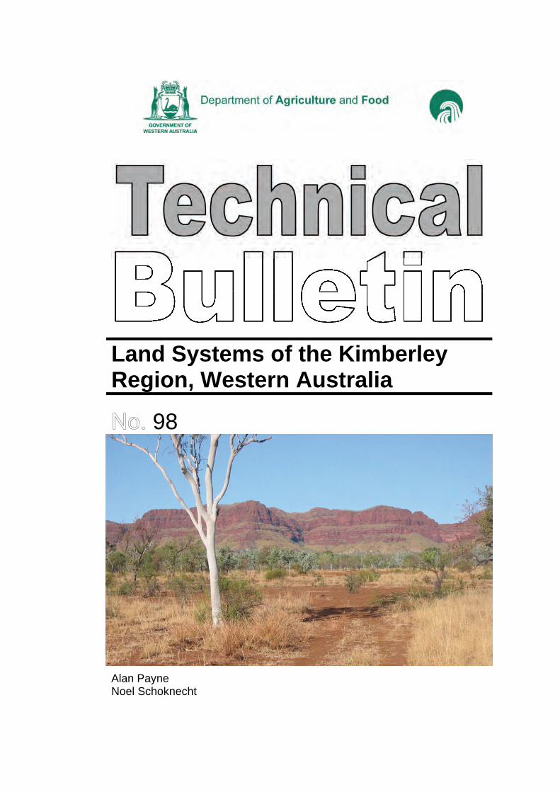
Front cover: Ragged Range, an impressive expression of Weaber land system, East Kimberley. Photo: Noel Schoknecht, DAFWA
Land systems of the Kimberley Region
ii
The authors Alan Payne, retired, formerly Senior Advisor, Rangeland Survey, Department of Agriculture and Food, Western Australia (DAFWA) and Noel Schoknecht, Senior Research Officer, Land Resource Assessment and Monitoring, Department of Agriculture and Food, Western Australia.
Acknowledgments Permission provided by Dr Neil McKenzie, Chief, Land and Water, CSIRO to reproduce land system descriptions originally described in CSIRO Land Research Series publications Nos. 4, 9 and 28 is gratefully acknowledged by the authors. The authors also acknowledge the significant contribution from the authors of the source land system publications upon which much of the text is based. The authors thank colleagues, particularly Peter Tille for the section on the State mapping hierarchy and general comments on the text, Andrew Craig for a comprehensive review of the final draft, Dave Hadden, Phil Thomas and Bob McCartney for constructive comments, Phil Goulding and Gabriela Seredenco for map production and Judi Fisher for electronic preparation of numerous early drafts. Acknowledgments for photographs are provided in the text. Aerial photography provided by and with the permission of the Western Australian Land Information Authority trading as Landgate.
Digital data disclaimer This mapping has been conducted at a regional scale. If using the digital linework (available from DAFWA), especially at larger scales (e.g. greater than 1:50,000), map boundaries may not exactly coincide with features on the ground. For some specific applications boundaries may require further revision.
National Library of Australia Cataloguing-in-Publication entry Payne AL 1940– . Land Systems of the Kimberley Region, Western Australia. Bibliography. ISBN 978-0-9806315-6-2. 1. Pastures – Western Australia – Kimberley.2. Rangelands – Western Australia – Kimberley.I. Schoknecht NR 1956– . II. Western Australia. Department of Agriculture and Food.III. Title. (Series: Technical Bulletin (Western Australia. Department of Agriculture andFood); No. 98).
Disclaimer
The Chief Executive Officer of the Department of Agriculture and Food and the State of Western Australia accept no liability whatsoever by reason of negligence or otherwise arising from the use or release of this information or any part of it.
Land systems of the Kimberley Region
iii
Contents Page
Purpose .................................................................................................................................... 1
History of land system surveys ................................................................................................. 1
Limitations of early surveys ...................................................................................................... 3
Mapping improvements ............................................................................................................ 4
Source of land system descriptions .......................................................................................... 4
State mappping hierarchy ........................................................................................................ 5
Pasture types ........................................................................................................................... 7
Land systems ........................................................................................................................... 9
References ........................................................................................................................... 240
Appendix 1: Pasture types of the Kimberley Region ............................................................ 242
Appendix 2: Pasture type grazing potential of the Kimberley Region................................... 248
Appendix 3: State land types ................................................................................................ 249
Index of Kimberley land systems .......................................................................................... 250
Map of Kimberley land systems ........................................................................................... 251
iv
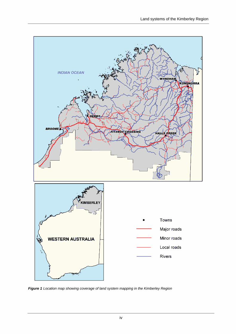
Figure 1 Location map showing coverage of land system mapping in the Kimberley Region
Land systems of the Kimberley Region

Land systems of the Kimberley Region
1
Purpose The main purpose of this report is to consolidate descriptions of the landscapes, soils and vegetation of the Kimberley Region of Western Australia from a succession of surveys carried out by different organisations since the 1940s. Reports of some of the surveys are unpublished or out of print. The purpose is achieved by listing and describing the 111 land systems which have been mapped in the region and by providing a joint land system and land type map. The Kimberley Region as defined in this report covers 330,070 km2 and its extent is shown in Figure 1. Lake Argyle, with a nominal area of 1021 km2, is included in the total area but unlike the source survey (Ord-Victoria) is not covered by land system mapping. Eighty-eight of the land systems have been previously described in three reports prepared as a result of major land resource surveys undertaken by the Commonwealth Scientific and Industrial Research Organisation (CSIRO) in 1949 and the 1950s. The remaining 23 land systems have been described as a result of subsequent surveys undertaken jointly by the Western Australian Department of Agriculture (now Department of Agriculture and Food - DAFWA) and the Department of Lands and Survey (now Landgate), jointly by the DAFWA and the Department of Environment and Conservation, or solely by DAFWA. This publication presents all systems for the first time arranged alphabetically in a standardised format.
History of land system surveys Broadscale land resource surveys covering the Kimberley Region of Western Australia commenced in 1949 by the CSIRO. Three major surveys (see Figure 2) described and mapped the area at the land system level. Field work for the first of these surveys (Ord-Victoria area) was undertaken in 1949 and 1952 but the report was not published until 1970 (Stewart et al. 1970). Field work for the other two surveys (North Kimberley and West Kimberley) was undertaken in 1954 and 1959 respectively with reports published by Speck et al. (1960, 1964). These surveys adopted the land system approach developed by Christian and Stewart (1953). A land system was defined as 'an area or group of areas through which there is a recurring pattern of topography, soils and vegetation'. These patterns can be readily seen and delineated by stereoscopic examination of aerial photographs. The interpreted land system boundaries are then verified by limited ground validation during field work. In the 1960s the Department of Lands and Surveys commenced a program of rangeland surveys in the Kimberley and Pilbara. These surveys classified the land into broad pasture types, mainly for the purpose of estimating paddock and station carrying capacities (Pringle 1991). Maps showing general landscape and vegetation attributes, but no accompanying reports, were produced during this program. The land system approach to resource mapping has stood the test of time. It was continued by CSIRO and the Department of Agriculture/Department of Lands and Surveys in numerous subsequent surveys in other rangeland regions of Western Australia. Nearly all WA rangelands where pastoralism is the primary land use are now described and mapped at the land system level.

Land systems of the Kimberley Region
2
Figure 2 CSIRO broadscale land resource surveys in Kimberley showing dates of field work
Publications Ord-Victoria (Stewart et al. 1970). Note: The area shown in Figure 1 is only the WA portion of the survey – the original survey included adjacent parts of the Northern Territory North Kimberley (Speck et al. 1960) West Kimberley (Speck et al. 1964)
Scanned copies of these reports are now available online at www.publish.csiro.au/nid/289.htm
Several more recent rangeland resource field surveys and a desktop exercise without ground validation have been undertaken in the Kimberley since the early CSIRO work (see Figure 3). Two surveys were jointly carried out by the Department of Agriculture and the Department of Lands and Surveys and three by the Department of Agriculture alone. Five reports have been published (Kubicki and Beer 1973; Payne et al. 1979; Ryan 1981; De Salis 1993; Cotching 2005). The desktop exercise (for the South Kimberley) was undertaken by the Department of Agriculture (Payne unpublished). As part of the Ord-Bonaparte Program in the early 2000s, the Department of Agriculture and Food conducted land unit mapping on several stations within the Ord River catchment (Carlton Hill, Ivanhoe, Bow River and Violet Valley) plus several small “training” areas throughout the catchment, and incorporated soil mapping from the Ord River Irrigation area. This work is detailed by Tille (in prep.). Following the methodology of this work, further land unit mapping by DAFWA and Department of Environment and Conservation (DEC) (Handasyde et al. 2009) included Texas Downs, Mabel Downs and Osmond Valley stations and the Osmond Ranges plus vegetation/land unit mapping in the Lower Ord Ramsar Sites.
Land systems of the Kimberley Region
3
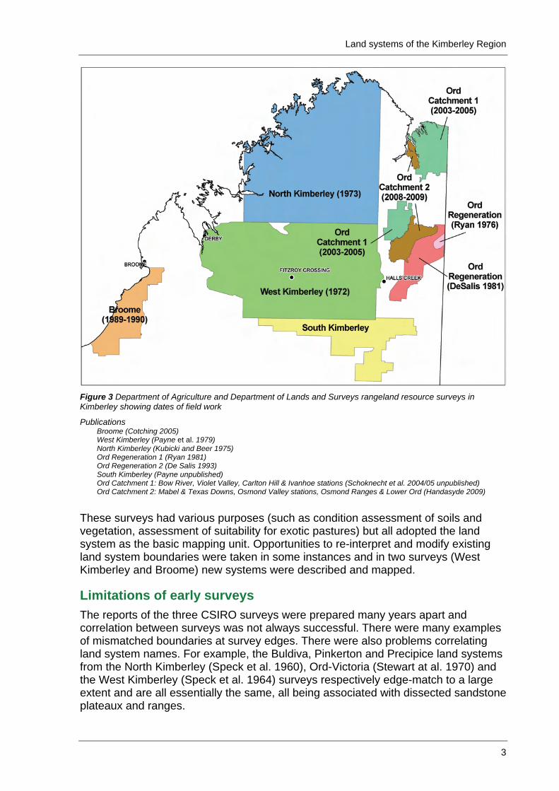
Figure 3 Department of Agriculture and Department of Lands and Surveys rangeland resource surveys in Kimberley showing dates of field work
Publications Broome (Cotching 2005) West Kimberley (Payne et al. 1979) North Kimberley (Kubicki and Beer 1975) Ord Regeneration 1 (Ryan 1981) Ord Regeneration 2 (De Salis 1993) South Kimberley (Payne unpublished) Ord Catchment 1: Bow River, Violet Valley, Carlton Hill & Ivanhoe stations (Schoknecht et al. 2004/05 unpublished) Ord Catchment 2: Mabel & Texas Downs, Osmond Valley stations, Osmond Ranges & Lower Ord (Handasyde 2009)
These surveys had various purposes (such as condition assessment of soils and vegetation, assessment of suitability for exotic pastures) but all adopted the land system as the basic mapping unit. Opportunities to re-interpret and modify existing land system boundaries were taken in some instances and in two surveys (West Kimberley and Broome) new systems were described and mapped.
Limitations of early surveys The reports of the three CSIRO surveys were prepared many years apart and correlation between surveys was not always successful. There were many examples of mismatched boundaries at survey edges. There were also problems correlating land system names. For example, the Buldiva, Pinkerton and Precipice land systems from the North Kimberley (Speck et al. 1960), Ord-Victoria (Stewart at al. 1970) and the West Kimberley (Speck et al. 1964) surveys respectively edge-match to a large extent and are all essentially the same, all being associated with dissected sandstone plateaux and ranges.
Land systems of the Kimberley Region
4
Problems of misregistration of the land system boundaries when drafting maps of the original surveys were common in some areas. Some examples of simple misinterpretation probably due to poor quality base maps or geological information (and limited ground validation) were also found.
Mapping improvements One of the earliest attempts to check and modify boundaries of land systems to improve the quality of the mapping was by Kubicki and Beer (1975). They investigated the suitability of land in the North Kimberley for the legume Townsville stylo and undertook considerable re-interpretation of the aerial photos, redrawing land system boundaries. This work was continued by Alan Payne who, in 1985, prepared a land system map showing the pastoral potential of the entire Kimberley Region. Where possible, he edge-matched boundaries from the three different CSIRO surveys and correlated the land systems. During the West Kimberley range condition survey (Payne et al. 1979) a small number of amendments were made to CSIRO land system boundaries and two new systems (Bulka and Landrigan) were described and mapped. Work in the Ord Regeneration area (Ryan 1981, De Salis 1993) remapped existing land systems down to the land unit scale and resulted in improved accuracy. The previously unmapped Broome coastal area was surveyed by Cotching in 1989 and 1990 where he mapped and described eight new land systems (Cotching 2005). Land system mapping in South Kimberley areas was undertaken as an ad hoc desktop exercise in the late 1990s and early 2000s by Alan Payne (unpublished). A number of new land systems were identified and tentatively described. These descriptions and maps are only provisional in that there was no ground validation. In 2007 and 2008 most land system boundaries in the Kimberley were checked and redrawn by Alan Payne, Noel Schoknecht and Phil Goulding. The interactive use of up-to-date digital geological, contour, terrain model and cadastre maps as well as LANDSAT imagery and Google Earth considerably increased the efficiency of amending boundaries. Misregistration errors have been largely removed. A report by Tille (in prep.) outlines the history of all Kimberley surveys in more detail and explains the methodology used in the recent preparation of improved maps.
Source of land system descriptions All land system descriptions are taken from previous reports except for 12 land system descriptions which are published for the first time. The original source of the descriptions is acknowledged as a code in the heading line for each of the land systems. Where the land system has not been previously published the source code is UNP with a link to a footnote describing the unpublished source for the description. Publication source codes and survey names:
BRM Broome survey (Cotching 2005) NKY North Kimberley survey (Speck et al. 1960) OVC Ord-Victoria survey (Stewart et al. 1970) PRP Pilbara ranges survey (Van Vreeswyk et al. 2004) UNP Unpublished WKC West Kimberley range condition survey (Payne et al. 1979) WKY West Kimberley survey (Speck et al. 1964)
Land systems of the Kimberley Region
5
Where necessary, the CSIRO descriptions have been updated by converting all measurements from imperial to metric units and by modernising the plant names. Layout of the descriptions has been amended and standardised as much as possible. No text has been altered other than consigning approximate area percentages to land units for each system where previous descriptors such as 'large', 'medium', 'very small', etc. were used. Each of the original CSIRO land system descriptions have had two additional headings added; namely State land type (see Appendix 3) and Land management. Vulnerabilities of the land system and management requirements for sustainable use are briefly described under the land management heading. In the case of the CSIRO North Kimberley report the original pasture description in each land system description has been deleted. In the case of the CSIRO North Kimberley and West Kimberley reports numbers in brackets in Soils and Vegetation sections refer to soil families and vegetation alliances/communities (numbers in bold type indicate dominants) in the original publications which should be referred to for further detail. All land system tables have had a pasture column added using Kimberley pasture type descriptions from Payne and Schoknecht (2004, unpublished) and Ryan et al. (2009). Previously unpublished descriptions are presented for 12 land systems (Bannerman, Betty, Billiluna, Cornish, Gilgie, Lake Gregory, Mulan, Snap, Spincrete, Sturt Creek, Texas and Wolfe), of which all except Texas occur in the South Kimberley. Descriptions for the 11 new land systems of the South Kimberley which were prepared by Alan Payne or officers of the Kununurra office of DAFWA are provisional as there has only been limited ground validation. The description for Texas is based on field work conducted as part of a land unit mapping exercise in the Ord River catchment (Handasyde et al. 2009).
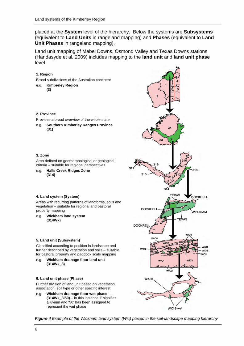
State mappping hierarchy The land system maps covering the Kimberley and other rangeland areas were completed as part of a survey programme separate from the land resource mapping undertaken in the Agricultural Area in the South-west of Western Australia (Schoknecht et al. 2004). Over the years these two programmes developed their own sets of standards, conventions and procedures. The desirability of a single dataset covering the entire state and capable of feeding into Australian Soil Resource Information System (ASRIS) led to reconciliation between the outputs of these two programmes. This included placing the rangeland land systems into DAFWA’s soil-landscape mapping hierarchy (Tille 2006). This soil-landscape hierarchy comprises six nested levels of mapping. Each level is a subdivision of the preceding one, with decreasing internal complexity of the map unit as the scale becomes more detailed (Schoknecht et al. 2004). The highest level of the hierarchy - Regions - is subdivided into Provinces. Both are aligned to the ASRIS national framework based on the mapping of Jennings and Mabbutt (1977), but their boundaries are derived from more detailed mapping in the lower levels of the hierarchy. The Provinces are sub-divided in Zones, and the zones into Systems (equivalent to Land Systems in rangeland mapping). The map units described in this report are
Land systems of the Kimberley Region
6
placed at the System level of the hierarchy. Below the systems are Subsystems (equivalent to Land Units in rangeland mapping) and Phases (equivalent to Land Unit Phases in rangeland mapping). Land unit mapping of Mabel Downs, Osmond Valley and Texas Downs stations (Handasyde et al. 2009) includes mapping to the land unit and land unit phase level. 1. Region Broad subdivisions of the Australian continent e.g. Kimberley Region (3)
2. Province Provides a broad overview of the whole state e.g. Southern Kimberley Ranges Province (31)
3. Zone Area defined on geomorphological or geological criteria – suitable for regional perspectives e.g. Halls Creek Ridges Zone (314)
4. Land system (System) Areas with recurring patterns of landforms, soils and vegetation – suitable for regional and pastoral property mapping e.g. Wickham land system (314Wk)
5. Land unit (Subsystem) Classified according to position in landscape and further described by vegetation and soils – suitable for pastoral property and paddock scale mapping e.g. Wickham drainage floor land unit (314Wk_8)
6. Land unit phase (Phase) Further division of land unit based on vegetation association, soil type or other specific interest e.g. Wickham drainage floor wet phase (314Wk_8l50) – in this instance ‘l’ signifies alluvium and ‘50’ has been assigned to represent the wet phase
Figure 4 Example of the Wickham land system (Wic) placed in the soil-landscape mapping hierarchy
Land systems of the Kimberley Region
7
Each map unit is assigned a symbol that is unique across the entire State. The place of the map unit in the hierarchy is implicit in the symbol: the first character of the label signifying the region; the 2nd the province; the 3rd the zone; the 4th and 5th the system; the 6th and 7th the subsystem; and the remainder (up to 12 characters) the phase. Figure 4 demonstrates the position of the Wickham land system in the soil-landscape hierarchy. The standard three letter rangeland land system code (Wic) has been replaced by the six character soil-landscape system code (314Wic).
Pasture types A standard set of pasture types for the entire Kimberley was created by Payne and Schoknecht in 2004 (unpublished) and is published for the first time in this report (see Appendix 1). This is an expansion of the pasture types of the West Kimberley described by Payne et al. (1974) and has similarities with some of the Pilbara pasture types described in the Pasture Condition Guides for the Pilbara (Payne and Mitchell 2002). Ryan et al. (2009) published pasture condition guides for the Ord River catchment of the most common Kimberley pasture types. In the Pilbara inventory and condition survey report (Van Vreeswyk et al. 2004) pasture types are referred to as site types. Some of the land system descriptions in this publication are derived from the Pilbara report, and in these instances either the site types from the Pilbara report are used where there is no Kimberley pasture type equivalent, or a Kimberley pasture type is used where the site type and pasture type are equivalent. There is also one new Kimberley pasture type derived from the Broome survey report (Cotching 2005). Up to four pasture types have been allocated proportionally (%) to each land unit of each land system. These proportions are estimates based on the original land system descriptions plus more recent traverse data. The proportions, and even the mix of pasture types, may vary within individual occurrences of each land unit. Proportions of pasture within land units types recorded in this document are based on the most recent available data. However, proportions are subject to change over time due to invasion by native and introduced species, seasonal conditions, fire frequency and grazing management. For example, Black Spear Grass Pastures (BSGP) have expanded their extent over the last 10-15 years at the expense of Ribbon Grass Pastures (RGRP), introduced Buffel Grass Pastures (BUGP) have invaded some coastal and alluvial plain land units and in some areas Arid Short Grass Pastures (ASGP) are being replaced by Ribbon Grass Pastures (RGRP) and Buffel Grass Pastures (BUGP). A summary of pasture types for the Kimberley is presented on the following page. Detailed pasture type descriptions are provided in Appendix 1. A guide to the grazing potential for each pasture type is provided in Appendix 2.

Land systems of the Kimberley Region
8
Pasture types of the Kimberley Region – summary, listed alphabetically by code Pasture type code Pasture type Source
APXG Alluvial Plain Mixed Grass Pastures Pilbara Survey - Site Types* ASGP Arid Short Grass Pastures Pasture types of the Kimberley region** ASHP Annual Sorghum Hill Pastures Pasture types of the Kimberley region** BGAP Bluegrass Alluvial Plain Pastures Pasture types of the Kimberley region** BSGP Black Speargrass Pastures Pasture types of the Kimberley region** BUGP Buffel Grass Pastures Pasture types of the Kimberley region** CAHP Curly Spinifex Annual Sorghum Hill Pastures Pasture types of the Kimberley region** CASG Calcrete Spinifex Pastures Pilbara Survey - Site Types* CDBG Coastal Dune Buffel Grass Pastures Pilbara Survey - Site Types* CDSG Coastal Dune Soft Spinifex Pastures Pilbara Survey - Site Types* COGP Cockatoo Grass Pastures Pasture types of the Kimberley region** CSPP Curly Spinifex Plain Pastures Pasture types of the Kimberley region** CTGP Coastal Tall Grass Pastures Pasture types of the Kimberley region** DEAW Drainage Eucalypt and Acacia Woodland/Shrubland
Pastures Pilbara Survey - Site Types* DMES Drainage Melaleuca Shrubland Pastures Pilbara Survey - Site Types* FRGP Frontage Grass Pastures Pasture types of the Kimberley region** FRIP Fringing Pastures Pasture types of the Kimberley region** HSHP Hard Spinifex Hill Pastures Pasture types of the Kimberley region** HSPP Hard Spinifex Plain Pastures Pasture types of the Kimberley region** LCSP Lowland Curly Spinifex Annual Sorghum Pastures Pasture types of the Kimberley region** LGAP Lovegrass Alluvial Plain Pastures Pasture types of the Kimberley region** LITP Littoral Pastures Pasture types of the Kimberley region** MACP Marine Couch Pastures Pasture types of the Kimberley region** MGAP Mitchell Grass Alluvial Plain Pastures Pasture types of the Kimberley region** MGUP Mitchell Grass Upland Pastures Pasture types of the Kimberley region** OERG Oat-eared Spinifex/Ribbon Grass Pastures Broome Coastal Survey Pasture Types*** OTHP Other Pastures Pasture types of the Kimberley region** PINP Pindan Pastures Pasture types of the Kimberley region** PLSP Plume Sorghum Pastures Pasture types of the Kimberley region** RAPP Ribbon Grass Alluvial Plain Pastures Pasture types of the Kimberley region** RGRP Ribbon Grass Pastures Pasture types of the Kimberley region** SHSG Sandplain Hard Spinifex Pastures Pilbara Survey - Site Types* SMPP Samphire Pastures Pasture types of the Kimberley region** SSPP Soft Spinifex Pastures Pasture types of the Kimberley region** SSSG Sandplain Soft Spinifex Pastures Pilbara Survey - Site Types* TAPP Threeawn Plain Pastures Pasture types of the Kimberley region** TTGP Tippera Tall Grass Plain Pastures Pasture types of the Kimberley region** WGBP White Grass Bundle-Bundle Pastures Pasture types of the Kimberley region** XXNP No Pastures Pasture types of the Kimberley region** * Van Vreeswyk et al. (2004). Note that Site Types in the Pilbara Survey are equivalent to Pasture Types in this report. ** Payne and Schoknecht (2004). *** Cotching (2005).
Land systems of the Kimberley Region
9
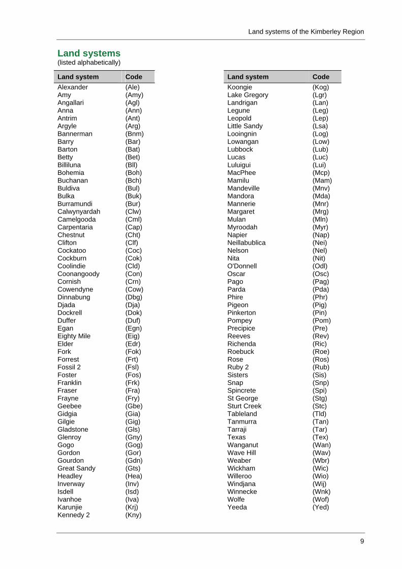
Land systems (listed alphabetically)
Land system Code Land system Code Alexander (Ale) Koongie (Kog)Amy (Amy) Lake Gregory (Lgr)Angallari (Agl) Landrigan (Lan)Anna (Ann) Legune (Leg)Antrim (Ant) Leopold (Lep)Argyle (Arg) Little Sandy (Lsa)Bannerman (Bnm) Looingnin (Log)Barry (Bar) Lowangan (Low)Barton (Bat) Lubbock (Lub)Betty (Bet) Lucas (Luc)Billiluna (Bll) Luluigui (Lui)Bohemia (Boh) MacPhee (Mcp)Buchanan (Bch) Mamilu (Mam)Buldiva (Bul) Mandeville (Mnv)Bulka (Buk) Mandora (Mda)Burramundi (Bur) Mannerie (Mnr)Calwynyardah (Clw) Margaret (Mrg) Camelgooda (Cml) Mulan (Mln)Carpentaria (Cap) Myroodah (Myr)Chestnut (Cht) Napier (Nap)Clifton (Clf) Neillabublica (Nei)Cockatoo (Coc) Nelson (Nel)Cockburn (Cok) Nita (Nit)Coolindie (Cld) O'Donnell (Odl)Coonangoody (Con) Oscar (Osc) Cornish (Crn) Pago (Pag)Cowendyne (Cow) Parda (Pda)Dinnabung (Dbg) Phire (Phr)Djada (Dja) Pigeon (Pig)Dockrell (Dok) Pinkerton (Pin)Duffer (Duf) Pompey (Pom)Egan (Egn) Precipice (Pre)Eighty Mile (Eig) Reeves (Rev) Elder (Edr) Richenda (Ric)Fork (Fok) Roebuck (Roe)Forrest (Frt) Rose (Ros)Fossil 2 (Fsl) Ruby 2 (Rub) Foster (Fos) Sisters (Sis)Franklin (Frk) Snap (Snp)Fraser (Fra) Spincrete (Spi)Frayne (Fry) St George (Stg)Geebee (Gbe) Sturt Creek (Stc)Gidgia (Gia) Tableland (Tld)Gilgie (Gig) Tanmurra (Tan)Gladstone (Gls) Tarraji (Tar)Glenroy (Gny) Texas (Tex)Gogo (Gog) Wanganut (Wan)Gordon (Gor) Wave Hill (Wav)Gourdon (Gdn) Weaber (Wbr)Great Sandy (Gts) Wickham (Wic) Headley (Hea) Willeroo (Wio)Inverway (Inv) Windjana (Wij)Isdell (Isd) Winnecke (Wnk)Ivanhoe (Iva) Wolfe (Wof)Karunjie (Krj) Yeeda (Yed)Kennedy 2 (Kny)