land protection plan shiloh national military park · land protection plan shiloh national military...
TRANSCRIPT
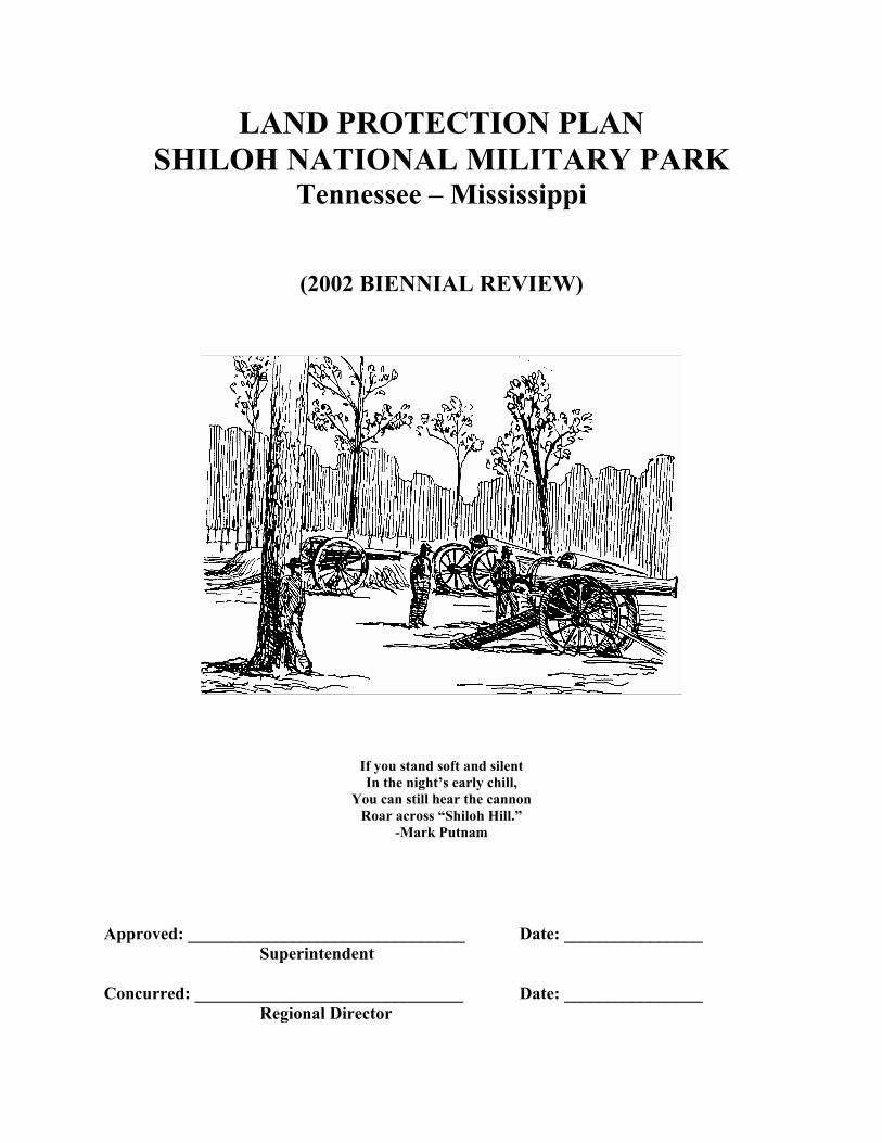
LAND PROTECTION PLAN SHILOH NATIONAL MILITARY PARK
Tennessee – Mississippi
(2002 BIENNIAL REVIEW)
If you stand soft and silent In the night’s early chill,
You can still hear the cannon Roar across “Shiloh Hill.”
-Mark Putnam
Approved: ________________________________ Date: ________________ Superintendent Concurred: _______________________________ Date: ________________
Regional Director
2
Contents
I. Introduction . . . . . . . . 3
II. Park Purpose, Significance, and Resources . . . . 4
III. Land Ownership and Uses . . . . . . 8
IV. Protection Alternatives . . . . . . . 15
V. Summary and Recommendations . . . . . 16
VI. Appendices . . . . . . . . 20 Maps Figure 1: Authorized Boundary of Shiloh National Military Park, as described in 1894 enabling legislation. . . . . . . . . 5 Figure 2: Non-federally owned lands within 1894 authorized boundary of Shiloh National Military Park (Divided into Tracts 1-13D). . . . . 7 Figure 3: Summary of land protection recommendation within the authorized boundaries of Shiloh National Military Park. . . . . . . 19

3
I. Introduction
A. Since its creation in 1916, the National Park Service has been charged with promoting and regulating the use of areas within the National Park System. The fundamental purpose of each park unit is “to conserve the scenery and the natural and historic objects and the wild life therein and to provide for the enjoyment of the same in such manner and by such means as will leave them unimpaired for the enjoyment of future generations.” Originally established under the War Department in 1894, Shiloh National Military Park was transferred to the administration of the NPS in 1933.
B. Land Protection Plans are prepared by the National Park Service (NPS) in response to
Department of the Interior policy for the Federal portion of the Land and Water Conservation Fund (47 FR 19784). A Land Protection Plan (LPP) is required for any unit in the National Park System containing non-Federal land within its authorized boundary. For two thirds of its length, Shiloh Battlefield’s 1894 authorized boundary line follows the watercourses around “Shiloh Hill,” a rolling plateau rising above the surrounding Tennessee River bottomlands. A strong defensive position, Shiloh Hill became the campsite for General Grant’s forces in March 1862, and thus the focus of the Confederate attack on April 6th & 7th. The park’s authorized boundary encloses about 6000 acres, of which two-thirds are currently in Federal ownership.
As Shiloh National Military Park (NMP) enters a new millennium, this Land Protection Plan will guide future actions to protect its resources, consistent with the purposes for which the park was created. Specifically it will do the following:
1) Determine the appropriate means of protection within the park’s authorized boundary, either by acquisition or otherwise.
2) Inform landowners about NPS intentions.
3) Set priorities for accomplishing land protection.
4) Identify opportunities for the National Park Service to cooperate with other
individuals and agencies.
[Note: Legislation passed in November 2000 created a separate “Corinth Unit,” greatly expanding Shiloh’s scope and mission. A Special Resource Study now underway will make recommendations to Congress on the size and shape of this new unit. Until that process is complete, the Shiloh LPP will concentrate on Shiloh Battlefield, the original unit of the park.]
C. This plan does not constitute an offer to purchase land or interest in land. It will
generally guide subsequent activities subject to the availability of funds and other constraints. It does not diminish the rights of non-Federal landowners.

4
II. Park Purpose, Significance, and Resources
A. The purpose of Shiloh National Military Park is to preserve and interpret the battlefield at Shiloh, and commemorate the people who fought there:
“In order that the armies of the southwest which served in the civil war…may have the history of one of their memorable battles preserved on the ground where they fought, the battlefield of Shiloh, in the State of Tennessee, is hereby declared to be a national military park…” [An Act to establish a national military park at the battlefield of Shiloh, approved December 27, 1894 (28 Stat 597)]. The goals of commemoration, preservation, and education, supported by battle veterans who lobbied for the park’s creation, have remained paramount since management of the military park transferred to the National Park Service in 1933.
B. Shiloh National Military Park preserves the site of a major Civil War battle, which
represented perhaps the best opportunity for a decisive Confederate victory in the western theater. Geographically, the momentous battle was fought on “Shiloh Hill,” a roughly 100-foot high, ten-mile square, geologic plateau bordering the west shoreline of the Tennessee River. This well drained section of the hill, or plateau, is surrounded on three sides by the river and several bottomland tributaries. Shiloh Hill and vicinity are notable today for a lack of modern intrusions onto the historic scene.
Due to the extended Union army encampment of Shiloh Hill before and after the battle, the area possesses a high concentration of archaeological resources relative to the Civil War. The park also contains one of the best-preserved Woodland – Late Mississippian prehistoric sites in the Tennessee River Valley: the Shiloh Indian Mounds National Historic Landmark.
C. The Park’s 1894 enabling legislation describes a boundary for Shiloh National
Military Park delimited by the drainages surrounding “Shiloh Hill:”
“Beginning at low-water mark on the north bank of Snake Creek where it empties into the Tennessee River; thence westwardly in a straight line to the point where the river road to Crumps Landing, Tennessee, crosses Snake Creek; thence along the channel of Snake Creek to Owl Creek; thence along the channel of Owl Creek to the crossing of the road to Purdy, Tennessee; thence southwardly in a straight line to the intersection of an east and west line drawn from the point where the road to Hamburg, Tennessee, crosses Lick Creek, near the mouth of the latter; thence eastward along the said east and west line to the point where the Hamburg Road crosses Lick Creek; thence along the channel of Lick Creek to the Tennessee River; then along low-water mark of the Tennessee River to the point of beginning.” (See Figure 1)

5
Figure 1: Authorized Boundary of Shiloh National Military Park, as described in 1894 enabling legislation
6
A National Military Park commission consisting of both Union and Confederate “Battle of Shiloh” veterans, working under the supervision and direction the Secretary of War, handled the affairs of establishing the park, acquiring title to battlefield lands, and adequately marking the field to tell the Shiloh story. Through the activities of this commission, the Secretary of War, within the park’s first two decades, procured title to much of the battlefield. Although authorized to use condemnation as a land acquisition tool, the commission acquired the majority of lands deemed necessary for development of the park by purchasing titles from willing landowners. By 1913, the park encompassed nearly five and half square miles of Shiloh Hill, including all of the areas of the heaviest fighting experienced in the two days of battle. When administration of the park was transferred to the National Park Service in 1933, the War Department transferred 3,715.53 acres to the Department of the Interior. Under NPS administration the following acreage has been acquired: 217.66 by purchase, 201.32 by donation and 1.71 by exchange. The park has disposed of 49.92 acres by exchange with private individuals. An additional 178.48 acres were returned to the State of Tennessee and Mississippi for use as highway rights of way. Based on the language of the 1894 Act, the Secretary of Interior has the authority to acquire any and all of the land contained within the authorized boundaries. (See Appendix B-Regional Solicitor’s memorandum on clarification of authorized boundaries, August 20, 1992)
D. Current Management Objectives relating to the protection of Shiloh Hill/Shiloh
Battlefield and vicinity.
1) Interpretation Interpret the Battle of Shiloh and its aftermath in the context of the western campaign of 1862. Commemorate the history of the battle and its participants by relating the compelling story to the actual ground where they fought. 2) Commemoration Maintain the battlefield’s system of historic markers and memorials in accordance with the Shiloh National Military Park Commission plan. 3) Cultural Resources Battlefield features – Preserve, maintain or restore the historical roads, fields, woods, and topography to reflect the area’s general appearance during the Battle of Shiloh.
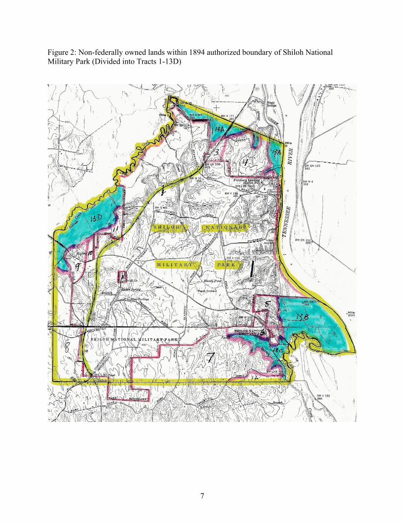
7
Figure 2: Non-federally owned lands within 1894 authorized boundary of Shiloh National Military Park (Divided into Tracts 1-13D)

8
Shiloh National Cemetery – Maintain a quiet, contemplative atmosphere within the cemetery. Preserve or restore landscape features to their general condition when transferred from the War Department in the 1930s. Shiloh Indian Mounds National Historic Landmark – Preserve archeological resources within the mounds complex. Salvage resources from any area facing imminent irreversible loss. Cultural Landscape – Preserve the rural agricultural character of Shiloh Battlefield and adjacent lands, in order to enhance visitor understanding of Shiloh’s history and significance.
III. Land Ownership and Uses
A. The current administrative boundary of Shiloh National Military Park’s Shiloh
Battlefield Unit contains 3962.82 acres: 3907.82 Federal, 51.00 Public, and 4.00 Private.
The non-Federally owned land includes two tracts (shown on Figure 2):
1. The Right of Way for Tennessee State Highway 22 (Public), and
2. The grounds of Shiloh United Methodist Church (Private).
There are approximately 2090 additional acres in private ownership within the park’s authorized boundary. For the purpose of this plan, this land is described in ten additional divisions:
3. Northern Entrance (State Route 22 south of Snake Creek Bottoms,
approximately 60 acres)
4. Hagy Land (northern edge of the park, 160 acres)
5. Greer Farm Upland (southeast corner above 400’ elevation, 50 acres)
6. Bowden Community (southeast corner above 400’ elevation, 60 acres)
7. Southern Edge of Battlefield (area north of Bark Road, 530 acres)
8. Shiloh Community (southwestern corner, 300 acres)
9. Hurley Community (western edge of the park, 50 acres)
10. R.A. Livingston Estate (west of Highway 22, 10 acres)

9
11. Blanton/Grey/Fullwood Property (west of State Route 22, approximately 40 acres)
12. Land South of Bark Road (20 acres)
13. Tennessee River Bottomland (All tracts below 400’ elevation, 850 acres)
13-A Snake Creek/TN River
13-B Greer Bottoms
13-C Spain Branch/Lick Creek
13-D Owl Creek
Appendix C details the historical significance of each of these tracts B. Existing and potential uses of non-Federal lands:
1. Right-of-Way for Tennessee State Highway 22
In 1958, the NPS deeded 51 acres on the western side of the park to the State of Tennessee for construction of the Highway 22 by-pass road. Relocation of this road to the western side of the battlefield necessitated the removal of several historic tablets. The relocated road has proved to be a major benefit to the park, removing much local and business traffic from the historic core of the battlefield.
2. Shiloh United Methodist Church
The congregation of Shiloh United Methodist Church maintains an active church on the historic site of the Methodist meetinghouse that gave its name to the Battle of Shiloh. The present stone and brick structure, completed in 1949, is the third to stand on the site. A reconstruction of the 1862 log church was completed in April 2001. The continuing use of the site as place of worship is compatible with the purpose of the park. The congregation’s future needs to expand either their sanctuary building or the adjoining church cemetery would be incompatible with the park’s objective of reflecting the area’s general appearance during the Battle of Shiloh. The need to provide the congregation with continuous access to this in holding impacts the NPS’s ability to close the park grounds after dark.
3. Northern Entrance (Along Highway 22 south of Owl Creek Bottom)
Current use of land bordering Highway 22 at the park’s northern entrance is not compatible with the park’s management objectives. Most visitors describe the collection of shacks, mobile homes, rusty cars, deteriorated buses, and beer hall west

10
of the highway as an “eyesore.” This visual blight is especially grating to motorists who encounter it after approaching the park over the two-mile long Snake Creek causeway traversing the bottomland to the north. Much of the land immediately east of the highway, for many years the site of an abandoned “tourist attraction” and amusement park, has recently been cleared. This four-acre site is now a prime business location.
4. Hagy Property (Northern edge of the Battlefield)
The Hagy family has held title of much of this land since well before the Civil War. A few single-family dwellings have threatened or obliterated the sites of several Federal camps in this area (including the loss and/or destruction of several government markers—Union camp tablets—erected by the original park commission on this land). The low density housing that borders Hagy road traversing this tract is currently screened from park view and does not impact battle resources or the visitor experience. Further commercial, residential, or industrial development would have significant negative impact on battle resources and the visitor experience.
5. Greer Farm Upland (Southeast corner above 400’ elevation)
This underdeveloped wooded tract at the southeastern corner of Shiloh Hill retains its 1862 character. Immediately adjacent to an important post battle tent field hospital site (NPS land), this tract witnessed heavy fighting on both days of battle. Any development here would not only destroy the historic resource, but also increase traffic through the park, which provides the area’s only land access during high water.
6. Bowden Community (Southeast corner above 400’ elevation)
This area contains around a dozen residences, many substandard in construction and in varying degrees of disrepair. Private ownership restricts visitor access to several key battle related troop position sites here. During periods of high water, the only road access to the outside world for these residents is across the adjoining National Military Park.
7. Southern Edge of the Battlefield (Area north at Bark Road)
The land north of historic Bark road is mostly agricultural or forest land, with unplanned development springing up along the road itself. Further loss of forest and farmland here to commercial, industrial, or further residential development, would destroy the sites of initial Confederate lines of battle and artillery positions and archaeological resources associated with Buell’s Army of the Ohio, April 15-29, 1862, encampments. Bark Road traverses a high ridge that overlooks the central core of the battlefield from a number of prominent locations.

11
8. Shiloh Community (Southwestern corner)
The unincorporated community of Shiloh adjoins the park’s administrative boundary at its southwest corner and rests astride the park’s southern entrance. Commercial developments located around the intersection of Highway 22 and 142 date to the mid 20th century. Currently, the junction supports a gas station, convenience store, restaurant/gift shop, RV and tent campground, and an abandoned hotel. Although these developments virtually obliterated all historic resources in this location, as long as the current structures are visually screened from the battlefield they have no major impact on the park visitor. Small farms and multi-acre single-family residences characterize the rest of this tract.
9. Hurley Community (Western edge of the park)
The small residential community of Hurley, astride Highway 142 (Purdy Road), witnessed both early and late battle action and contains the sites of several Federal campsites. The administrative record detailing the original placement of several government-owned historic plaques and markers on private land within this tract is limited. All surviving markers are currently located within the state highway right-of-way. Commercial development here would impact the approach of visitors from the west.
10. R.A. Livingston Estate (West of Highway 22)
The northwestern section of the R.A. Livingston estate, approximately 30 acres, originally intended as the completion of Livingston’s 1978 donation to the park, was willed at his death to Shiloh United Methodist Church. Later, the church transferred two-thirds of the acreage to Livingston’s surviving nephew. The area is wooded, although selective clearing has occurred. Development here would greatly alter the rural appearance of the Highway 22 and 142 intersection and scenic corridor.
11. Blanton/Grey/Fullwood Property (West of Highway 22)
A single-family residence (plus a barn) adjoining Highway 22 are the principal developments found on this tract. These structures are a visual interruption to the historic fields and woods of the battlefield along the three-mile scenic southern approach to the main entrance located at Pittsburg Landing Road. Further commercial, industrial, or residential development would produce an incompatible visual intrusion to the historic scene found on the battlefield’s west side.
12. Land South of Bark Road (20 acres)
Development along historic Bark Road has isolated this small section from the undeveloped land to the north. Conditions are the same as those described in Tract 7.

12
13. Tennessee River Bottomland (All tracts below 400’) About 850 acres of non-Federal land is located in the flood plain of the Tennessee River, that is, below the 400-foot elevation line. Most of this area is considered wetlands. A considerable amount of this land was inundated by high water on April 6-7, 1862; and annual flooding continues to preclude major development in this zone. The current agriculture use is compatible with the purpose of the park. A significant archaeological record exists for prehistoric human activity within virtually all of the bottomland tracts. A particularly high concentration of that activity (based on representative artifact quantities) is evident in Track 13 B., located immediately north of the confluence of Lick Creek and Tennessee River.
C. External Conditions
Outside the city limits of Savannah, TN., there are no zoning regulations in Hardin County. Zoning in the Shiloh area would require a countywide planning effort, something that will not happen in the foreseeable future. Thus all non-Federally owned land near the battlefield is susceptible to unregulated development that could negatively impact park resources and values. A common occurrence is nearby timberland harvested for the local paper mill, often followed by the introduction of mobile homes or substandard housing. The impact of unregulated development due to a lack of planning and control has accelerated over the last decade, and increased the pressure of commuter traffic through the battlefield. To date, the worst of this type of development has occurred at the park’s northern entrance on Highway 22, and has included commercial business in shacks and substandard buildings, a trash dump, a beer joint, and an amusement park, all within sight of the main entrance. As long as this “no zoning” situation exists, the only way for the park to control development within its authorized boundaries will be to acquire an interest in the land. Surrounding land below 400 feet elevation is subject to annual flooding. Other than agriculture, development within these bottomlands is limited to elevated residential structures, such as weekend cottages that could withstand high water.
Shiloh’s rugged topography and predominantly forested conditions dictate that park visitors, from most locations within the existing National Military Park boundary, cannot see distant landmarks. Only along the Tennessee River does the visitor gain vantage points that provide significant long distance views outside the authorized boundary. From the bluffs overlooking the river at the National Cemetery, the Indian Mounds, and the “Union Left” overlook position, the high ground marking the eastern geological extent of the three-mile wide Tennessee River floodplain is visible to the east. Development on this distant high ground would have only minor impact on the visitor experience. However, recreational development along the eastern riverbank itself would have a dramatic impact on what today is a view with few intrusions on the historic scene.
D. Brief History of Protection at Shiloh Battlefield
In the century following the Battle of Shiloh, the area’s slow growth and development preserved to a remarkable extent the natural and cultural landscape features of forests and

13
clearings, which characterized the area in 1862. One telling statistic is the 2000 census was the first to record the population of Hardin County as greater than the total of killed, wounded, and missing at the “Battle of Shiloh.” In terms of preservation of Shiloh Battlefield, the park was fortunate the area did not undergo widespread agricultural or industrial development after the war. When the movement to establish the park began, the battlefield had undergone little significant change. The land, undeveloped over much of the battle area, could be had at a price the Federal government was able to pay. Isolation, which has long retarded the area’s progress, preserved Hardin County’s great battlefield and made possible the development of the National Military Park on a scale otherwise impossible. From the park’s establishment in 1894, management has attempted to acquire the land on Shiloh Hill. The authorized boundary includes all of the opposing lines of battle and contains the areas of the heaviest fighting in the two days of battle. All of the land acquired to date has been in fee simple. The 1894 Shiloh NMP Act provided that title to battlefield lands could be acquired by the Secretary of War under either an act to authorize the condemnation of land for site of public buildings (August 1, 1888) or under “an act to establish and protect national cemeteries” (February 27, 1867). In 1893, a “Shiloh Battlefield Association” took options on 2,300 acres. After the park’s establishment, the Park Commission had difficulty in working with this group to transfer these options. The Commission decided to proceed with acquisition of land not under option, and wait for the Association options to expire in 1896. In July 1895, condemnation proceedings were started to acquire the tract which included Pittsburg Landing. These proceedings progressed favorably, and by the following summer the tract was acquired at a cost of $6,000, as contrasted with the $25,000 asked by the owners. In March 1896, the Battlefield Association’s options expired and the way was cleared for rapid acquisition of the area. At the close of 1896, the Government had title to only 85 acres of park land, but by the end of the following year, 2,095 acres had been acquired at an average cost of $12.70 per acre. An actual survey of the battlefield found the boundaries described in the original Shiloh bill included almost 6,000 acres, rather that the estimate of “three thousand acres, more or less…” given in the bill. Most of the bottomland acreage included within the boundaries described in the original bill was excluded from the Park Commission’s initial acquisition program. The majority of high ground within the boundaries, a total of 3,546 acres, was acquired by 1913. The next large extension of park lands occurred in 1924 when the Federal Government took title to 105 acres of the Shiloh-Corinth Road right-of-way from the Corinth, Shiloh, and Savannah Turnpike Company. Within three decades, this Shiloh-Corinth National Road was eventually transferred back to the states of Tennessee (State Route 22) and Mississippi (State Route 2). Throughout the twentieth century, several smaller holdings were acquired, most of them an acre or less in extent. By November 1954, the park administrative history documented the park included over 3,729 acres. The park continues to acquire additional land (mostly through donation) on “Shiloh Hill,” within the legislated authorized boundary, when properties become available.
14
E. Status of Protection Program
Of the 6,054 acres within the authorized boundary, the government has managed to acquire a total of 3,917.82 (an additional 55 acres of Nonfederal acreage resides within the current National Park boundary). Recent acquisitions have depended on the efforts of preservation groups. They have occurred on a “willing seller/willing buyer” basis. There are no condemnations in progress. However, the park has openly entertained the offered of a “friendly” condemnation with members of a local family holding interest in land adjacent to the north park entrance as means of determining clear title to property currently encumbered under by a family trust arrangement.
F. Local landowners view the park from four different perspectives. The first group regards the park as a buffer to protect their land from adverse development. Some of these people have an appreciation of the cultural and natural resource values of the park. A second group sees the park as taking land out of production, thus reducing the county’s tax base. They are probably the smallest group. A third group is in the business of making money off the park visitor. For the most part, they have little appreciation for the park except as a heritage tourism generator. Anything interfering with tourist flow, no matter how beneficial it would be for park protection and preservation, would be opposed. The last group has an active interest in the preservation of the park as a nationally significant historical site. They frequently work the third group. Relations with the local community governments are good. The Hardin County government views the park as a key to the local tourism industry, and thus an important part of the local economy. This same attitude is held in the communities of Savannah and Adamsville, Tennessee; and Corinth, Mississippi. Residents of the immediate community surrounding the battlefield have historically commuted across the park. Park neighbors are in the habit of cutting through the park day and night searching for the shortest and best way to and from Bark Road and the Hamburg bottomlands. In addition, park roads are the only routes out of the Bowden community during periods of high water (on the average of five-ten days a year). This non-recreational access has led to resource violations such as extensive littering, poaching, vandalism, and theft of government property (plaques and commemorative features removed from monuments). In addition, three beer taverns reside in and around the park. Unrestricted access to park roads leads to increased levels of driving under the influence and speeding as patrons exit the taverns and travel on public roads—with the attendant threats to park visitors and resources.
15
IV. Protection Alternatives
A. Any development in the Tennessee River floodplain is regulated by Federal law regarding wetlands, and Tennessee State law regarding water quality. Currently, no Federal, State, or local laws/authorities provide for resource protection, allow for management, or provide for visitor use of non-Federal land residing within the authorized boundary above the existing floodplain.
B. Description of reasonable alternative methods for protecting land to carry out the
purpose of the park, listed by tract number, and in order of increasing effectiveness.
1. Right-of-Way for Tennessee State Highway 22 a. Take no action. b. Move Highway 22 off Shiloh Hill, and restore historic contour along current
Right of Way.
2. Shiloh United Methodist Church a. Take no action. b. Acquire easement restricting future commercial development. c. NPS acquisition by willing seller.
3. Northern Entrance
a. Take no action. b. NPS acquisition by condemnation c. NPS acquisition by willing seller
4. Hagy Property a. Take no action. b. Acquire easement restricting development to single family residential uses c. Acquire agricultural easements d. NPS acquisition by willing seller
5. Greer Farm Upland a. Take no action b. Agricultural easement on bottomlands c. NPS acquisition by condemnation d. NPS acquisition by willing seller.
6. Bowden Community a. Take no action. b. Construct bridge or causeway across Lick Creek to allow access from the
south during periods of high water. c. NPS acquisition by condemnation d. NPS acquisition by willing seller.

16
7. Southern Edge of the Battlefield (Bark Road area) a. Take no action. b. Secure easements to historical marker sites. c. Acquire agricultural easements. d. NPS acquisition by condemnation. e. NPS acquisition by willing seller.
8. Shiloh Community a. Take no action. b. Encourage facilities (such as well designed restaurants or low-rise motels) to
support visitor need.
9. Hurley Community a. Take no action. b. Secure easements to historical marker sites. c. Acquire easements restricting development to single-family residential uses. d. NPS acquisition by willing seller.
10. R.A. Livingston Estate
a. Take no action. b. Acquire forest easement. c. NPS acquisition fee simple (a possible site for later relocation of Shiloh
United Methodist Church.)
11. Blanton/Grey/Fullwood Property a. Take no action. b. NPS acquisition of residence on Highway 22, agricultural easement on
remainder of high ground c. NPS acquisition by condemnation d. NPS acquisition by willing seller
12. South of Bark Road
a. Take no action. b. Secure agricultural easement through donation.
13. Tennessee River Bottomland a. Take no action. b. Accept donations of agricultural easements. c. NPS acquisition of bottomland at SE corner of the park.
V. Summary and Recommendations
“Shiloh Hill,” the 1862 United States Army campsite that became the scene of one of the Civil War’s bloodiest battles, comprises the northern half of a topographical plateau surrounded on three sides by Tennessee bottomland. Lobbying for the establishment of

17
Shiloh National Military Park, battle veterans realized the importance of preserving this historic resource in its entirety. As a result, from the center of Shiloh Hill, the park’s 1894 authorized boundary extends to the watercourses of the flood plain for an almost 270 degree arc, from the west clockwise to the southeast. The local area’s 100-year flood plain (areas below the 400 foot elevation contour) is shaded in blue on the map in Figure 3. The authorized boundary is shown in red; the park’s current boundary is shown in green. The land adjoining Shiloh National Military Park remains largely rural. Largely for this reason, Shiloh Battlefield has maintained a state of preservation that permits the visitor, as one prominent historian has observed, to “still hear the guns roar.” Noted author Shelby Foote describes Shiloh as “the best preserved of the Civil War battlefields.” Yet despite this lofty position, Shiloh remains highly susceptible to threats of development and encroachment outside its current boundary. The area’s agricultural scene received no protection through preservation zoning. Given the county’s political climate, this situation is unlikely to change in the foreseeable future. However, Shiloh Battlefield’s unique geographic position provides the opportunity to use the surrounding flood plain as a natural buffer zone to preserve the park’s rural character. The annually flooded Tennessee River bottomlands are tantalizingly close to the current boundary of the military park. The addition of less than 150 acres at the park’s northern and western edges (shown in orange) would create an uninterrupted three-mile greenway for motorists approaching the park’s main entrance from either direction on Highway 22. Another 125-acre addition to the park’s southeast corner north of Spain Branch (also shown in orange in Figure 3) would preserve vegetation and topography on that key historic ground. The addition of this land would enable the park to exclude commuter traffic, and close the grounds at dark. Further south, land lying roughly between Spain Branch and historic Bark Road contains the locations of Confederate deployment on the first day of battle, plus the initial lines of advance and field artillery positions. In addition, a significant portion of closing battle movements and action associated with the second day of fighting are located on this land, as well as Buell’s Army of the Ohio encampments from April 15-29, 1862. Several historic plaques dot this area. To fully interpret both the opening and closing stages of the battle, most of this land needs to be added to the park.
Areas on the map marked in yellow are above the 400-foot line and within the authorized boundary. They would make a valuable addition to the park, but are less critical to a “Shiloh Hill” preservation concept.
Specific recommendations by tract are given below: Tract #1 Right-of-Way for Tennessee State Highway 22
Recommendation: Take no action. ( a )

18
Tract #2 Shiloh United Methodist Church Recommendation: NPS acquisition if church ever becomes a willing seller. ( b )
Tract #3 Northern Entrance
Recommendation: NPS acquisition by condemnation. ( c ) Tract #4 Hagy Property
NPS acquisition by willing seller. ( d ) Tract #5 Greer Farm Upland
NPS acquisition by willing seller. ( b ) Tract #6 Bowden Community
NPS acquisition by willing seller(s). (d ) Tract #7 Southern Edge of the Battlefield (Bark Road area)
NPS acquisition by willing seller. ( e ) Tract #8 Shiloh Community
Take no action. ( a ) Tract #9 Hurley Community
Secure easements to any historical marker sites not in State right-of-way. ( b ) Tract #10 R.A. Livingston Estate
NPS acquisition by willing seller. ( d ) Tract #11 Blanton/Grey/Fullwood Property
NPS acquisition by willing seller. ( d ) Tract #12 South of Bark Road
Secure agricultural easements through donation. ( b ) Tract #13 Tennessee River Bottomland
Accept donations of agricultural easements (13 A & D), and NPS acquisition by willing seller (13 B & C). ( c )
Other: Tennessee River opposite bank and view shed
Accept donations of agricultural easements. ( d )

19
Figure 3: Summary of land protection recommendation within the authorized boundaries of Shiloh National Military Park.

20
Appendices
A. An Act to establish a national military park at the battlefield of Shiloh, approved December 27, 1894 (28 Stat 597)
B. Memorandum to Regional Director, NPS, SERO from Regional Solicitor,
Southeast Region, dated August 20, 1992, on Clarification of Authorized Boundaries for Shiloh National Military Park.
C. Historical Significance of non-Federally Owned Tracts within Authorized
Boundaries of Shiloh National Military Park.

21
Appendix A
An Act to establish a national military park at the battlefield of Shiloh, approved December 27, 1894 (28 Stat 597); and subsequent legislation.
22

23

24
Appendix B
Memorandum to Regional Director, NPS, SERO from Regional Solicitor, Southeast Region, dated August 20, 1992, on Clarification of Authorized Boundaries for Shiloh National Military Park.

25

26

27

28

29

30
Appendix C
Historical Significance (relative to the Battle of Shiloh) of non-Federally Owned Tracts within the Authorized Boundaries of Shiloh National Military Park (See Figure 2 Map) 1. The Right of Way for Tennessee State Highway 22 (51 acres of Public Land):
This 51-acre tract cuts through the campsites of three Federal infantry regiments (40th Illinois, 58th Illinois, and 14th Missouri) and one Federal battery (Dresser’s Battery [D], 2nd Illinois Light Artillery). It witnessed large-scale troop maneuver and savage combat during both days of the Battle of Shiloh (April 6-7, 1862) [“D.W. Reed/Atwell Thompson Maps, #1 & 2, Shiloh Battlefield Commission, (1903-04)” (cited afterwards as “RTM”)]. April 6: Elements of Sterling A. M. Wood’s and Patrick R. Cleburne’s Confederate brigades, deployed on the left of Maj. Gen. William J. Hardee’s 3rd Corps line of battle, bivouacked the night of April 5-6 on this tract north of the modern Highway 142 intersection at Ed Shaw’s store. When battle erupted on Sunday, Cleburne advanced along (north) and across (east) this tract to strike Union Brig. Gen. William T. Sherman’s 5th Division camps at Shiloh meetinghouse. While Cleburne attacked to the northeast, Col. Preston Pond’s Confederate brigade, supported on the left by Brewer’s Mississippi and Alabama cavalry Battalion and Morgan’s Company of Kentucky Cavalry, held the rebel left flank anchored on Owl Creek. Pond advanced north, (his right flank crossing this tract) weakly demonstrating against Col. John A. McDowell’s Federal brigade deployed north of Shiloh Branch. Between 8 and 10 a.m., the 40th Illinois Infantry was in line of battle, 300 yards south of their camp, astride this tract and neighboring NPS lands. At 10 a.m., with his left flank turned and threatened, Sherman withdrew his division, including McDowell’s force, off of the Shiloh Branch line to the Hamburg – Purdy road. This permitted Colonel Pond to advance his brigade into McDowell’s abandoned camps where it halted to rest (during all of these movements, Pond’s right flank remained astride this tract) [Reed, David W. The Battle of Shiloh and the Organizations Engaged, Washington, 1902, pp.12-14, 55-6, 71, 78, & 80 (cited here after as DWR); “RTM #1”]. In departing his camps, McDowell attempted to move east to join Sherman at the crossroads north of the church, but found his path blocked by Confederates (probably elements of Anderson’s and Cleburne’s brigade). Cut off, McDowell withdrew to the north and moved towards Crescent field. There, at 10:30, the Union colonel discovered the rapidly advancing Confederate front had occupied the eastern portion of Crescent field. Cutoff from joining Sherman, McDowell proceeded into the field (Tract 4: Blanton/Grey/Fullwood property), advancing east (over this tract) to engage the Confederates. These vanguard elements of the advancing Southern army were brushed aside, permitting McDowell to retire northward unmolested, to Sowell field. This detached Federal brigade formed a line of battle, facing south. In this position, at 11:30, Colonel McDowell communicated with his division commander, Sherman, whose immediate force had likewise been forced to retire northward into Jones field, located east of the Sowell farm. At noon, acting in semi-concert with the co-mingled command under Maj. Gen. John A. McClernand, Sherman ordered McDowell’s brigade forward in

31
a desperate counterattack. The Federal front surged southward for 800 yards, driving the left flank of the Confederate army back to Water Oaks Pond. During this action, McDowell’s front initially advanced astride this tract, and then across it (southeast), to a point just northwest of Woolf field [DWR, pp.17, 56-7, & 77; The War of the Rebellion: A Compilation of the Official Records of the Union and Confederate Armies. 73 vols., 128 parts, Washington, 1880-1901, Series I, X, pt. 1, pp. 250, 254, & 256 (here-after cited as O.R.); & “RTM #1”]. Shortly after noon, supported on his right by three detached infantry regiments of Cleburne’s brigade, Preston Pond advanced northeast from McDowell’s camps, with three of his own regiments, accompanied by four guns of Ketchum’s Alabama Battery (during this movement, Pond’s center remained astride this tract). The Southern forces occupying this left sector of the Confederate battlefront, commanded by Maj. Gen. William J. Hardee (Maj. Gen. Leonidas Polk commanded the sector on Hardee’s right), engaged Sherman’s force then located east of Crescent field. Reinforced by the arrival of Robert Trabue’s brigade and elements of Robert Russell’s brigade, Hardee fought a determined action with Sherman’s people (the forces under Polk were engaged primarily on McClernand’s front) for the next two hours. By 2 p.m., the entire Federal front had been forced to grudgingly give ground [DWR, pp.17, 67-8, 71, & 78; O.R., Series I, X, pt.1, pp. 588, 616; & “RTM #1”]. At 2:00 p.m., Sherman and McClernand once again found themselves occupying a weakening line of battle in Jones field. Both agreed to withdraw their bloodied commands to a new position east of Tilghman Branch. Colonel Pond, with three of his Louisiana regiments, still occupied Hardee’s left (astride this tract facing northeast on a ridge south of Sowell field) supported by Brewer’s cavalry on the left, pursued the Federals into the northern section Jones field. For the next hour, the Confederate offensive on Hardee’s, as well as Leonidas Polk’s front, was hampered by a severe ammunition shortage. While they waited to be re-supplied, Pond’s men occupied a position in Abraham Hare’s captured Union camps near the David Harmon house. At 4 o’clock, Pond received orders to attack across Tilghman Branch to silence a Federal battery east of the creek. Colonel Brewer’s horse soldiers continued to cover Pond’s left and moved northward (his right flank troopers astride this tract) through Glover field towards Tilghman Branch. This movement threatened the Savannah – Hamburg (or River) road, but at 4:30 p.m., Brewer’s advance was checked and repulsed by the 14th Missouri Infantry. The Missourians anchored Grant’s right south of the River road in the vicinity of the western section of Russian Tenant field (NPS land), their line extending east onto the farm owned by James Perry occupying this track and additional ground to the east (NPS land). Pond’s attack, supported by Wharton’s Texas Rangers on the right, advancing across the rugged valley of Tilghman Branch was likewise repulsed with heavy losses in the three Louisiana infantry units. The battered Confederates retreated west into Jones field where Pond rested his bloodied command in Hare’s camps for the night. The left center of the brigade rested astride this track now occupied by Tennessee State Route 22 [DWR, pp.18, 45-7, 49-50, & 78-80; O.R., Series I, X, pt. 1, pp. 516, 521, & 528 “RTM #1”]. That evening, Maj. Gen. Lew Wallace’s division marched onto the field via the River road to reinforce Grant. Wallace deployed his men along the Savannah – Hamburg road,

32
his right flank located in the Russian Tenant field, his left in Perry field. State Route 22 slices through the ground occupied by Thompson’s 9th Indiana Battery and the junction of the right flank of Morgan L. Smith’s brigade with the left flank of John M. Thayer’s brigade, both organizations assigned to Wallace’s division [DWR, p. 51; & “RTM #2”]. April 7: The battle resumed early with an artillery duel between Lew Wallace’s field artillery (i.e., Thurber’s Missouri and Thompson’s Indiana batteries, supported by Bouton’s unassigned Illinois battery) and Ketchum’s Alabama Battery deployed on the north edge of Jones field near Colonel Hare’s abandoned brigade headquarters. When ordered forward (south: parallel and astride the route of Highway 22), Wallace’s division advanced across the broad valley of Tilghman Branch at 6:30 a.m. For the next hour the stronger Union division steadily forced Pond’s infantry and Ketchum’s battery to retire southward. After securing the northern end of Jones field, Wallace held his ground astride this tract and waited for the impending arrival of Sherman’s command. That Federal force was expected to advance west across the Tilghman valley to connect with and support Wallace’s left. In this exposed position Wallace was attacked by a Confederate force advancing into south Jones field. Hastily organized by General Daniel Ruggles, this makeshift rebel effort used elements of Sterling Wood’s and Randall Gibson’s brigades. The Confederate attack slid diagonally across Wallace’s front permitting the Federal troops to pour a destructive flank fire into the exposed rebel line. In addition, field batteries posted on Sherman’s and McClernand’s sectors east of Tilghman Branch raked the rebel ranks with a heavy cannonade. Wood and Gibson retired, seeking cover in the woods south and west of Jones field. Shortly after 9:30 a.m., Sherman’s men entered the eastern portion of Jones field and engaged Confederate forces deployed in line of battle south and west of the field. Now supported, Wallace resumed the advance, moving south by southwest (along State Route 22). The Federal division conducted a left wheel movement into Sowell field, turning the Confederate left, defended by elements of Robert Russell’s brigade, reinforced by Benjamin F. Cheatham’s division. Steadily, at times haltingly, throughout the afternoon, Wallace advanced southwest (astride this tract) fighting through Crescent and Ben Howell fields. This movement, made in conjunction with the further advance of forces under Sherman and McClernand, slowly pressed the Confederate left rearward, eventually forcing the rebels south of the Hamburg – Purdy road, permitting Wallace to recover McDowell’s Federal brigade camp. His division pressed southward across Shiloh Branch, reaching the vicinity of north Fraley field, where Wallace received orders to quit the action. His division retired upon McDowell’s camps and bivouacked for the night [DWR, pp. 20-2, 51-3, 79-81, & 83-4; O.R., Series I, X, pt. 1, pp. 171-73, 480-81, 593-94; & “RTM #2”].
2. The Grounds of Shiloh United Methodist Church (4 acres):
Site of the original Shiloh meeting house, a small log Methodist church (served also as a school and public house) with an adjoining cemetery, the cultural landscape feature that gave the bitterly contested battle its name. The church (the current building resides approximately on the original site) was located on a ridge north of Shiloh Branch, east of,

33
and adjacent to the north-south Corinth road. On 19 March 1862, two Ohio infantry regiments (70th and 77th) assigned to William T. Sherman’s division established portions of their regimental camps on the church tract. This non-federal tract resides within one of Shiloh’s most awesome killing zones, and witnessed some of the heaviest and most intense fighting in the two days of bitter combat [DWR, p. 9; & “RTM #1”]. April 6: At 7:15-7:30 a.m., Patrick Cleburne’s Confederate brigade advanced across Sherman’s front (from southwest to the northeast) and awkwardly slammed into the awaiting Federal brigades of Ralph Buckland (south and west of the church) and Jesse Hildebrand (south and east of the church), supported by cannon from the Illinois batteries of Waterhouse, Taylor, and Schwartz. Taylor’s battery unlimbered six cannon within the actual churchyard, astride the Corinth road in immediate support of the 77th Ohio Infantry to the left front and 70th Ohio Infantry on the right front (site is commemorated onsite with an Illinois organization monument on the southwest corner of this tract). In its attempt to negotiate the valley of Shiloh Branch, Cleburne’s brigade was cut to pieces by murderous volleys of Federal musketry and artillery fire. The Confederate troops comprising his left flank struggled through the dense underbrush of Shiloh Branch only to emerge fragmented directly in the path of Sherman’s destructive fire. Meanwhile, Cleburne’s right, advancing onto an exposed knoll of a ridge located on the north end of Rea field, 450 yards southeast of the church, was completely shattered by an intense crossfire from Hildebrand and Buckland lines. At 8:30 a.m., Col. Julius Raith advanced his brigade (detached from John A. McClernand’s division) of four Illinois regiments, the 17th, 29th, 43rd, and 49th, to the direct support of Sherman, extending the Federal front another 600 yards further east of the church. The 17th Illinois deployed in direct support of Taylor’s battery, the right of the regiment anchored in the churchyard (the regiment is commemorated onsite with an Illinois monument immediately south of the current church). For the next hour, Sherman, assisted by Raith, defended this naturally strong position. Four rebel brigades (Patrick Cleburne’s, Patton Anderson’s, Robert Russell’s, and Bushrod Johnson’s) slammed into Sherman’s front between 8-9 a.m. The Federal fire inflicted heavy casualties, shattering brigade and regimental organization, and temporarily brought the Confederate offensive to an abrupt halt on this flank [DWR, pp.13-16, 55-8, 45, 47, 71, 77, 80, & 83; O.R., Series I, X, pt. 1, pp. 249, 444, 496-97, & 580-81; & “RTM #1”]. Between 9-10 a.m., S. A. M. Wood’s and Robert Shaver’s brigades, supported by three brigades under Alexander P. Stewart, Randall Gibson, and William Stephens, in response to direct orders from the their army commander Albert Sidney Johnston, advanced northwest from the captured Federal camps of Benjamin Prentiss’s 6th Division. These massed brigades slammed into Raith’s exposed left flank driving him northwest. In addition, the four badly mauled and disorganized Confederate brigades initially repulsed on Sherman’s front, also surged forward. With Raith’s force driven back, and his own left flank turned and crumbling (Hildebrand’s brigade ceased to exist as an organized combat force) under the crushing weight of six Confederate brigades, General Sherman ordered a complete withdrawal of remaining Union forces from the Shiloh Church line. This force retired two-tenths mile northward, where they linked up with McClernand’s division on a new defensive position along the Hamburg – Purdy road. In their wake, the victorious
34
Confederates took possession of Sherman’s abandoned camps [DWR, pp. 16, 55-8, 47, & 71, 77, 80, & 83; & “RTM#1”].
From this position eleven Confederate brigades surged northward astride the Corinth road, between 10 and 11 a.m., and slammed into the new front defended by Sherman and McClernand at the junction (“crossroads”) of the Corinth – Pittsburg and Hamburg – Purdy roads. In making this movement, co-mingled elements of Cleburne’s, Anderson’s, Russell’s and Johnson’s Confederate brigades moved across the United Methodist tract. Just before noon, Confederate Gen. Pierre Gustave Toutant Beauregard, supervising the Southern offensive in this sector, established his headquarters in the vicinity of the church. Confederate medical personnel also utilized the now battle-scarred church, and surrounding grounds, as a makeshift field hospital. That night, at the close of the first day of fighting, the remains of the fallen southern army leader Gen. Albert Sidney Johnston rested in an ambulance near the church, before being transported back to Corinth the next morning. A portion of the exhausted Confederate army bivouacked on this tract during the night [DWR, pp.16-17; O.R., Series I, Vol. X, pt. 1, p. 401; Roland, Charles P. Albert Sidney Johnston: Soldier of Three Republics, Austin, 1964, p. 339; & “RTM #1”].
April 7: At noon, as attacking Federal forces hammered his left flank and center, Beauregard, commanding the army following Sidney Johnston’s death, personally directed desperate countercharges from his field headquarters located at Shiloh Church. Although these desperate attacks inflicted heavy casualties on the aggressive National forces, temporarily stalling the Federal advance at Water Oaks Pond, between 1 and 2 p.m., Beauregard’s troops were eventually forced to retire south of the Hamburg – Purdy road by the combined massive weight of both Grant and Buell’s armies. Then holding the Corinth road line of retreat at Shiloh Church, was Trabue’s brigade (north of the church its center immediately west of the Corinth road). Along with Trabue, the 3rd Confederate Infantry (Shaver’s brigade) was positioned astride the road north of the church, and cannon from Bankhead’s Tennessee Battery (Russell’s brigade) with the 11th Louisiana Infantry (Anderson’s brigade) in direct support, was deployed in the roadway. This line of battle lay 350 yards south of the “crossroads,” and occupied the north end of this tract, where they are today commemorated with iron position tablets and original Civil War cannon. At about 2 p.m., Beauregard ordered his army to retreat. To secure a safe withdrawal, he personally placed Col. Robert Looney, commanding the 38th Tennessee (Pond’s brigade) with his regiment, augmented by detachments from five additional regiments (an approximate total of 1,000 men), at Shiloh Church, and directed Looney force to charge the Union center. In this charge, Looney advanced northward from this tract, over the site of Sherman’s headquarters, to near the Hamburg – Purdy road; at the same time, Beauregard sent several batteries across Shiloh Branch to form a concentrated battery on the high ground beyond, directly athwart the Corinth road. With these deployments, Beauregard safely crossed Shiloh Branch after 4 p.m. and moved south along the Corinth road. The rear guard, under the command of Brig. Gen. John C. Breckinridge, retired to ground occupied by the Confederate Army, on April 5, before the battle, and bivouacked for the evening. The Federals reoccupied all the ground north and east of Shiloh Branch

35
and halted for the evening. William T. Sherman’s forces, bivouacked in their reclaimed Shiloh Church camps that included this tract [DWR, pp. 22-3, 79, & 86-7; O.R., Vol. X, pt. 1, pp. 388 & 402; Battlefield Position Tablets #313, 423, & 455; & “RTM #2”].
3. Northern Entrance (adjacent to Tennessee State Route 22 south of Snake Creek Bottoms, approximately 60 acres):
Although this area saw no direct combat action on either day of battle, upon their arrival at Pittsburg Landing on March 18, 1862, three Illinois infantry regiments (50th, 57th, and 58th Infantry) assigned to Sweeny’s brigade. Charles F. Smith’s (later W.H.L. Wallace’s) division, established camps on this property. Also encamped on a portion of this property, were the extreme right of the 8th Iowa Infantry (Sweeny’s brigade) and the right elements of the 2nd Illinois Cavalry. After called to alert on 6 April, the infantry regiments formed on their color lines at 8 a.m., where under orders from Brig. Gen. W.H.L. Wallace they advanced south to engage the Confederate offensive along the threatened forward sectors of the Federal encampment. At the close of the first day’s action, the Federal right flank rested astride the Hamburg – Savannah road about 300 yards southwest of this tract. After the battle the three Illinois regiments returned to their camps, although 40 % of the 58th Illinois had been captured at the Hornets’ Nest. The survivors buried their dead (20 men) just northeast of their regimental camp. The bodies of the National dead were later exhumed and removed to Shiloh National Cemetery [DWR, p. 48; “RTM #1”; & 58th Illinois Burial Marker].
4. Hagy Land (northern edge of the park, 160 acres): This property witnessed no combat. Prior to the battle, the regimental camps of the12th Iowa Infantry and the left half of the 7th Iowa Infantry, both in Col. James Tuttle’s brigade, assigned to Charles F. Smith’s (later W.H.L. Wallace’s) division, were established on the southeastern section of this tract. Both organizations turned out for action on their respective color lines at 8 a.m., 6 April, and advanced to the front with their brigade (Wallace’s) at 8:30. The brigade deployed on its first line of battle a mile and a half southwest of this tract on the east side of Duncan field [DWR, p. 48; & “RTM #1”]. The eastern section of this tract contained elements of the camps of the 57th and 58th Illinois Infantry, which were documented in the previous tract (#3).
5. Greer Farm Upland (southeast corner above 400’ elevation, 50 acres):
April 6: At 9 a.m., southern forces under the personal direction of Confederate Army commander Gen. Albert Sidney Johnston captured Benjamin Prentiss’ 6th Division Federal camp. From there Johnston issued orders directing several of the brigades towards other sections of the front and against perceived threats on the field. Informed that a large Union force threatened his right, Johnston ordered Brig. Gen. James Chalmers and Col. John K. Jackson to advance their brigades east, to the extreme Confederate right (Tract 7), to attack the Federal force and drive it from the field. With Col. James Clanton’s Alabama cavalry regiment in the lead, Chalmers and Jackson moved by the right flank down the Bark road until the cavalry reached Lick Creek. The

36
Confederates formed line of battle, facing left (north) parallel with the road along the bluff south of Locust Grove Creek [now Spain Branch] on Tract 7. The batteries of Capt. Gage (Alabama), and Capt. Girardey (Georgia) unlimbered to sight their guns on the enemy camp visible to the north. The camp proved to be the billets of Col. David Stuart’s brigade, positioned astride the junction the Savannah – Hamburg and Hamburg – Purdy roads atop the ridge north of the creek [DWR, pp. 13-14, 56-7, 74-5; Battlefield Position Tablets #399 & 409; & “RTM #1”]. The Confederates moved forward at 11 a.m. (from Tract 7 and over Tract 6), following a preliminary artillery bombardment, driving in Union pickets. The southern advance forced Colonel Stuart’s brigade of Union infantry, exposed and unsupported by artillery, to abandon its initial line of battle and its brigade camps. Reduced to only two infantry regiments, his third having broken and withdrawn because of the fire of Gage’s and Girardey’s batteries, Stuart rallied his remaining troops to the left and rear (northeast) of his abandoned camps. Cut off from direct assistance from the main body of the Federal army, Stuart utilized the timbered ravines and ridges for cover. His men managed a stubborn two-hour defense of this position [the left of the 54th Ohio Infantry occupied this tract, and engaged Clanton’s cavalry and the right flank elements of Chalmers’ brigade. The Confederate advance was held in check until 2 p.m. Further west (on NPS land), Jackson’s brigade stormed through Stuart’s camps, advancing north into ravines located behind the camp. The southern advance was brought to an abrupt halt in the deep ravines by a murderous fire. This fire was delivered by two regiments from John A. McArthur’s brigade, drawn up in line of battle 700 yards northwest of Stuart’s current front, supported by the brigade under Nelson Williams deployed along the southern edge of the large peach orchard located on the farm of the widow Sarah Bell. In addition, Mann’s Missouri Battery and Willard’s Illinois Battery directed close range artillery fire into the attacking Confederate force. At noon, Jackson was reinforced by the arrival of Brig. Gen. John A. Bowen’s brigade. For the next hour, these two rebel brigades hammered McArthur’s troops, inflicting heavy casualties on the Federal regiments. As a result, McArthur steadily, but grudgingly, gave ground. The gradual retirement of this Federal sector, allowed Jackson to pass two regiments east to support Chalmers’ men engaged with Stuart. Thus outnumbered, engaged on three fronts, and lacking ammunition and manpower, Stuart’s weakened command retreated across this tract. Most of the command fled northwest to the River road (a small number of the men withdrew northeast to the river where they were picked up by a Federal gunboat). Once safely within the main Federal line, Stuart’s column marched to Pittsburg Landing. His front uncovered, Chalmers followed the retreating Federals, slowly advancing northwest, where his brigade, Jackson’s and Bowen’s engaged McArthur’s cut-up command, now reinforced with Col. Jacob Lauman’s brigade of Hurlbut’s division, on a new line east of widow Wicker’s field. The steadfast stand by Stuart, supported by McArthur and elements of Hurlbut, seriously disrupted and delayed the efforts of the Confederates to first turn and then roll up Grant’s left flank. A movement which would have accomplished the Confederate battle objective of cutting Grant’s line of retreat to the river, and either capture or destroy his army on the field [DWR, pp. 14-15, 17, 50, 56-7, 74-5, & 87-8; & “RTM #1”].
37
April 7: In the final actions of the second day of fighting, between 1 and 4 p.m., the extreme left flank of Brig. Gen. William Nelson’s 4th Division, an element of Maj. Gen. Don Carlos Buell’s Army of the Ohio, advanced across this tract. The attacking Federals steadily drove James Chalmers’ Confederate brigade southward. Nelson’s force halted on the Hamburg road and bivouacked in Stuart’s re-occupied camps Monday night [DWR, pp. 63 & 75; & “RTM #2”].
6. Bowden Community (southeast corner of park above 400’ elevation, 60 acres):
The individual properties found within this tract represent a portion of the battlefield traversed by Chalmers’ and Jackson’s brigades in their initial assaults on Stuart’s brigade camps. This action is documented in the preceding narrative for Tract 5 (Greer Farm Upland).
April 6: The 54th Ohio (Zouave) Infantry (Stuart’s brigade), forming the right flank element of the Union army, deployed behind the cover of a wooded fence line located on the north edge of Squire David McCuller’s field. Shortly before 11 a.m., the 52nd Tennessee Infantry, deployed as skirmishers for Chalmers’ brigade, advanced northward astride the Hamburg road in McCuller’s field (Chalmers moved from Tract 7 across track 13C to reach this location). As they approached the northern end of the field the Tennesseans walked into an ambush delivered by the Ohio Zouaves. Under this murderous fire, the 52nd Tennessee broke and retreated from the field. Officers were only able to rally two companies of the regiment to continue the battle. The action in McCuller’s field forced Chalmers to halt, call for ammunition, and reform the brigade, prior to resuming the advance at noon [DWR, pp. 57 & 74; & “RTM #1”].
7. Southern Edge of the Battlefield (area north of Bark road, 530 acres): Patterson Tract and land west of the old Eastern Corinth road
April 6: When Col. Everett Peabody (Prentiss’ division) advanced his brigade to engage Maj. Gen. William J. Hardee’s approaching corps battleline at 7:30 a.m., General Prentiss advanced Col. Madison Miller’s brigade to the south edge of Spain field. Miller deployed in line of battle on Peabody’s left, facing south. To support Miller and command the avenue of direct approach along the Eastern Corinth road, Prentiss placed Hickenlooper’s 5th Ohio Battery on the western edge of Spain field left (east) of the road, and sighted Munch’s 1st Minnesota Battery within the woods to the right of the road. At 8 a.m., Miller was assaulted by the right of Hardee’s line of battle, Brig. Gen. Adley H. Gladden’s brigade that had been detached to Hardee’s assistance from Braxton Bragg’s 2nd Corps [DWR, pp.13, 58-60; & “RTM #1”]. Gladden advanced north across Tract 7, astride the Eastern Corinth road, on the right of Col. Robert Shaver’s brigade, which in turn slammed into Peabody’s position (on NPS land) west of the road. Gladden’s initial attack on Miller’s line failed, as did Shaver’s delivered against Peabody. At 8 a.m., Gladden was reinforced on his right by the arrival of James Chalmers’ brigade. Both rebel units attacked north across this tract. In this
38
heavily contested action General Gladden was mortally wounded. However, a sustained Confederate pressure eventually drove Miller’s troops back to a second line (the front of his camps). Minutes earlier, Peabody had been forced to retire his men to their brigade camp. In defense of its camps, Prentiss’ division was vigorously assaulted by four Confederate brigades, from left to right, Wood, Shaver, Gladden (now commanded by Col. Daniel Adams), and Chalmers. At 9 o’clock, Prentiss’s entire command was driven from its division camps, having suffered the loss of two guns from Hickenlooper’s battery and heavy casualties. Among the killed was Colonel Peabody commanding the 1st Brigade of Prentiss’ division [DWR, pp. 13, 58-60, 73-4; & “RTM #1”]. Later, this tract was traversed by Jackson’s, Bowen’s, and Statham’s brigades, as they maneuvered to deliver their initial attacks on the left center and left flank of Ulysses S. Grant’s Federal line of battle, then deployed to the north (NPS land) and northeast (Tract’s 5, 6, and 13C) beyond the Hamburg – Purdy Road. Hudson’s (Pettus) Mississippi Battery unlimbered and went into action on this tract, deploying six cannon on the bluff (roughly 400 yards west of the old Shake-A-Rag Church site) east of the Eastern Corinth road overlooking the valley of Locust Grove (or Spain) branch. Hudson’s cannon assisted the ten field pieces assigned to Girardey’s and Gage’s batteries, in delivering a long-range artillery bombardment on Federal forces deployed for battle along the Hamburg – Purdy Road [DWR, pp. 75, 87-8; “RTM #1”; & Battlefield Position Tablets #399 & 409].
Shake-A-Rag Church Hill:
April 6: After conducting a midmorning right flank march eastward along Bark road (refer to Tract 5, titled Greer Farm Upland), Chalmers and Jackson moved their infantry brigades north onto this terrain, deploying in line of battle between 10:30 and 11 a.m. in preparations to making an assault over Locust Grove branch. Girardey’s Georgia Battery unlimbered near the site of the old Shake-A-Rag Church, while Gage’s Alabama Battery took position on a prominent knoll 600 yards further east. These two batteries opened a long-range bombardment on Hurlbut’s and Stuart’s commands deployed for battle along the Hamburg – Purdy road line [DWR, pp. 74-5; “RTM #1”; & Battlefield Position Tablets #399 & 409].
Bark Road Area:
Refer to Patterson Tract… and Tract 5 (Greer Farm Upland) for initial documentation of specific troop maneuver and combat on this land.
The right flank of Colonel Shaver’s Confederate brigade, and virtually all elements of both Gladden’s and Chalmers’ brigades, traversed this tract, under direct artillery and musket fire from United States forces, in their initial attacks on Prentiss’ division. Later, just prior to noon, two additional Confederate brigades under John Bowen and Winfield Statham, assigned to John C. Breckinridge’s Reserve Corps, deployed for battle on this tract east of the Eastern Corinth road. From here, Breckinridge advanced his force north

39
(entering NPS land) where the two brigades engaged National troops beyond the Hamburg – Purdy road [DWR, pp. 13, 17, 70, 74, & 87-8; & “RTM #1”]. After the battle, on the 15th of April, with the arrival of its baggage, Buell’s Army of the Ohio moved approximately one mile from its encampments on the battlefield to higher ground bordering Lick Creek. The left flank of the army rested on the creek, near the Hamburg road ford (this ground found on this Tract, #7), and the right flank on (NPS land) William T. Sherman’s division of Grant’s army. Buell’s divisions remained in these camps until April 29, 1862 [Duke, Cecil A. The Siege of Corinth, Mississippi. Historical Reports (circa 1934-36) Shiloh National Military Park Administrative Files, pp. 7-8; and O.R. Series I, Vol. X, pt. 1, p. 672].
8. Shiloh Community (southwestern corner of park, approximately 300 acres):
On 5 April 1862, the center and left wing elements of Hardee’s Corps, occupied this tract, in line of battle, as they conducted their final deployments for the planned attack on Grant’s army. Patrick Cleburne’s large brigade, anchoring Hardee’s left on the Owl Creek bottom, bivouacked on this ground astride the old Howell road (current Pratt Lane). On the morning of April 6, Cleburne advanced northeast from this tract towards Sherman’s divisional camps at Shiloh meetinghouse. The left of Braxton Bragg’s corps (Anderson’s and Pond’s brigades), having bivouacked in line of battle 800 yards in rear of Hardee’s initial line of battle, slowly followed Cleburne forward. In doing so, these rebel forces tramped across this ground, moving steadily north and east. Colonel Pond divided his command, and sent three infantry regiments, supported by a section of Ketchum’s battery, to the northern end of this tract. There, on a point of ground located south of Shiloh Branch, and opposite the 6th Iowa camp of McDowell’s Federal brigade, Pond deployed this force. These Confederates lightly demonstrated against McDowell’s brigade positioned south of the Purdy road. In response to Sherman’s orders, McDowell retired from his camps at 10:00 a.m. In this wake, Pond advanced north and claimed McDowell’s abandoned camps and seized control of the Owl Creek bridge on the Purdy road [DWR, 12-14, 67-71, & 77-8; & “RTM #1”]. The Confederates retained control of this area through the closing actions of the afternoon of 7 April. At that time, the Confederate left flank, retreated across this ground to the southwest [DWR, pp. 22-3; & “RTM #2”].
9. Hurley Community (western edge of the park, 50 acres):
April 6: The camps of the 6th Iowa and the 46th Ohio Infantry, of McDowell’s brigade, were located upon this tract, south of the Hamburg – Purdy road, established along the plateau overlooking the confluence of Shiloh Branch with Owl Creek. After battle erupted in Fraley field, General Sherman’s pickets discovered the advance of Cleburne’s and Pond’s Confederate brigades south of Shiloh Branch in Widow Howell’s field (Tract 8). Alerted to the approach of enemy forces of unknown size, Col. John A. McDowell, commanding Sherman’s 1st Brigade, had Companies D and K of the 6th Iowa remain at their picket outpost to cover the bridge across Owl Creek (Tract 13D). McDowell advanced the bulk of his brigade forward, 200-300 yards, and deployed in line of battle,
40
on this tract, overlooking Shiloh Branch. Behr’s (Morton’s) 6th Indiana Battery, supported McDowell’s movements by unlimbering their six cannon along the southern edge of the battery camp (on NPS property at the former R.A. Livingston residence) established in the southwest corner of Ben Howell field. The Union artillerists engaged in a long-range counter battery duel with Ketchum’s Alabama Battery positioned south (on Tract 8) of the valley of the branch. At 8 a.m., Colonel Pond detached the 38th Tennessee Infantry, the Crescent Louisiana Regiment, and one section of Ketchum’s Battery, and shifted them a mile and a half to the left. This force moved to a position (north end of Tract 8) directly south of the 6th Iowa camp located at Owl Creek Bridge and maneuvered in an effort to turn McDowell’s right flank (Tract 9 and southern section of 13D). The remaining regiments of Pond’s brigade, supported by the other four guns of Ketchum’s Battery, shifted east to connect with the left of Anderson’s brigade. This force advanced to Shiloh Branch, where they skirmished with McDowell’s brigade (all this action involves Tracts 9 and 13D, and adjoining NPS lands). At 10 a.m., McDowell received orders from Sherman to withdraw. When the Federal brigade abandoned its position and retired northeast, Pond entered McDowell’s camps without further resistance [DWR, pp. 14-17, 55-6, & 78; & “RTM #1”].
10. R.A. Livingston Estate (west of Highway 22, 10 acres):
For the complete description of events transpiring on this tract, please refer to the activities involving Pond’s brigade, following the capture of McDowell’s camps on April 6, and the account of Maj. Gen. Lewis Wallace’s advance against the Confederate left in the closing combat activities on April 7, previously documented in the narrative for Tract 1, titled The Right of Way for Tennessee Highway 22. Colonel Pond’s brigade advanced north through Tract 10 before noon on April 6; while Lew Wallace, moved south to engage the left flank elements of the Confederate army, on this property, at the close of combat action on the afternoon of April 7 [DWR, pp. 51-3, & 78-9; & “RTM #1 & 2”].
11. Blanton/Grey/Fullwood Property (west of State Route 22, approximately 40 acres):
Events previously detailed in the narrative for Tract 1 (The Right of Way for Tennessee State Highway 22) covers the various phases of combat associated with this property.
April 6: This specific tract of the Shiloh plateau contains the western section of Crescent field and adjoining woodlands, on which Col. John A. McDowell’s brigade fought to clear Confederate forces from his line of retreat and continue his withdrawal north into Sowell field. McDowell deployed his brigade along the western edge of the open field, and advanced east-northeast to drive back Confederate forces (probably elements of Anderson’s and Cleburne’s brigades) occupying the east side of the field. Shortly after 12 o’clock, the brigades of Preston Pond (3 regiments), three detached regiments from Cleburne, two of Robert Russell’s regiments and the major part of Robert Trabue’s brigade, supported by Brewer’s and Wharton’s mounted cavalry, attacked northeast across Crescent field. The extreme left flank of this Confederate force passed across this tract, attacking into the ravine east of the field, where they engaged the Federal

41
counterattack delivered by Sherman and McClernand [DWR, pp. 16-17, 56, 71, 78, 80-81, & 86; “RTM #1”]. April 7: In the early afternoon, the 78th and 20th Ohio Infantry assigned to Col. Charles Whittlesey’s brigade were shifted from General Lew Wallace’s left flank, in Jones field (NPS land), to the extreme right flank beyond Thayer’s brigade. This shift in position extended the threatened Union right flank to Owl Creek. Once deployed in line of battle, the 20th Ohio in front with the 78th in reserve, Whittlesey advanced when Wallace directed his entire division front to move southwest into Crescent field. Here Wallace continued to battle the Confederate left flank, held by elements of Russell’s and Pond’s brigades, slowly forcing the rebel line southward towards Ben Howell field. Whittlesey passed through the western edge of Crescent field by 2 p.m., and engaged Confederate troops on the north edge of Ben Howell field. The Confederate line of battle occupied the northern end of McDowell’s old camps positioned along west-east Purdy road (in Tracts 1, 8, 10, and adjoining NPS land) [DWR, pp. 52-3, 79, 81; O.R. Vol. X., pt. 1, pp.172-3, 194, 200-02; & “RTM #2”].
13. Tennessee River Bottomland (All tracts below 400’ elevation, roughly 850 acres):
On 6-7 April 1862, the Tennessee River stood at flood stage with an approximate elevation of 372-375 feet above sea level. Recent heavy rain on April 4-5 left the marshy bottomlands occupying the river floodplain inundated by surface water and flood backwater. These conditions did not permit large-scale troop movements, or combat, to develop within the bottomland. Naval Activities: When battle erupted on shore, the morning of April 6, the Union Gunboat Tyler maneuvered to assist Ulysses S. Grant’s army. At 9:25 a.m., Lt. Wm. Gwin stationed the vessel one-mile upstream of Pittsburg Landing (probably near the bend in the river off Brown’s Landing). Gwin placed the vessel in a good position to support army troops ashore “should they be forced down to the banks of the river.” At 10:15 the Gunboat Lexington, Lt. James Shirk commanding, arrived from Crump’s Landing to join the Tyler. After a short time on station, Shirk steamed downriver back to Crump’s to support Lew Wallace’s division, whose division camps occupied ground ashore at that point. At mid-afternoon, Brig. Gen. Stephen Hurlbut requested Gwin to support the Union left with naval artillery fire. The heavy guns aboard the Tyler engaged in this activity for an hour, before Gwin ordered the vessel downstream to Pittsburg. At 4 p.m., Shirk returned with the Lexington. The two gunboats took position three-fourths of a mile above Pittsburg and opened heavy fire in direction of the rebel batteries on their right. The southern cannon were quickly silenced. At 5:35, the Confederates gained a position on the left of the Union line, immediately south of Dill Branch, an eighth of a mile above the landing at Pittsburg and a quarter mile inland from the river. The two gunboats opened a heavy and well-directed fire on the nearest body of Confederates (brigades of Chalmers and Jackson) attempting an attack north across the valley of Dill Branch, supported by the six cannon from Gage’s Alabama Battery. This naval artillery fire, in conjunction
42
with Union field artillery (over 50 cannon) ashore, overwhelmed silenced the Confederate guns and repulsed the final Confederate offensive action of the day. Later that evening, gun crews aboard the two vessels opened a deliberate indirect fire against Confederate forces occupying the captured Union army camps ashore. This intermittent bombardment continued until 5 a.m., April 7 when the combined armies of Grant and Buell assumed the offensive. The gunboats saw no further action on the second day of battle [DWR, 9 & 12; & Official Records of the Union and Confederate Navies in the War of the Rebellion. 31 vols., Washington, 1895-1929, Serial I, Vol. XXII, pp. 762-66] In addition to the two armed Federal gunboats, a small number of unarmed transports and hospital ships (estimated at eleven to fourteen vessels total) engaged in service and support operations during the two days of battle [Correspondence from Stacy D. Allen to Wiley Sword, January 29, 1999, Shiloh National Military Park Administrative Files]. 13A. Snake Creek & Tennessee River Bottom: No direct combat actions occurred on land associated with this tract. However, over shooting ordnance fired at long ranges by Confederate field artillery during the closing actions on April 6, did impact on this tract (particularly on ground immediately north of Pittsburg Landing). In addition, panic stricken Federal troops, their military organizations shattered from intense combat experienced on the front, did retreat into this tract during the first day of combat. This gathering of stragglers was particularly evident on that section of this tract located adjacent to the river. Graphic accounts of thousands of panicked Union stragglers and the chaos associated with rear echelon activities in and around Pittsburg Landing are documented in scores of primary sources. The location of Wallace Bridge, which crossed Snake Creek (now Owl Creek) on the Hamburg – Savannah (or River) road, is located on NPS land immediately adjacent to the extreme western portion of this tract. It was across this bridge that General Lew Wallace’s division entered the battlefield to reinforce Grant on the evening of April 6, [DWR, pp.16, 19, 51; O.R., Series I, Vol. X, pt. 1, pp. 324 & 333; & RTM #1] 13B. Greer Bottom: The movement of Confederate forces and combat documented earlier in Tract 5 (Greer Farm Upland) and Tract 6 (Bowden Community) cover the significance of battle events transpiring on this tract. The 10th Mississippi Infantry, forming the right of Chalmers’ brigade, supported by Clanton’s Alabama Cavalry regiment, directly maneuvered and fought on this bottomland tract during the afternoon of April 6. These Confederate forces came under naval artillery fire from the U.S. Gunboat Tyler (and perhaps the Lexington before she steamed downriver to Crump’s). The Mississippians fired on the vessel with small arms. The road linking the Upper (or Buell’s) landing to the Hamburg road crossed proceeded across this bottomland tract. After the battle of Shiloh, this bottomland road experienced heavy use after Buell opened the Upper Landing to facilitate service and supply for his army and field hospitals [DWR, pp. 14, 73-74; O.R., Series I, Vol. X, pt. 1, pp. 549-550; Correspondence from R.F. Learned to Maj. D.W. Reed, March 22, 1904,

43
Shiloh National Military Park Administrative Files; “RTM #1 & 2; & Bearss, Edwin C., Shiloh Historical Base Map Report, National Park Service, 1973, cited here-after as HBM]. In addition to battle related resources, virtually every tract on or surrounding the current NPS boundary, contains some degree of a prehistoric cultural resource component. These archaeological resources are associated with the indigenous Late Woodland through Late Mississippian occupation of the temple mound and village complex constituting Shiloh Indian Mounds National Historic Landmark located within the boundary of the National Military Park. Due to its immediate and adjacent proximity to the Shiloh Indian Mounds NHL property, this particular bottomland tract contains a greater abundance of prehistoric resources than other associated tracts. 13C. Spain (historic Locust Grove) Branch and Lick Creek:
Movements of the Confederate forces and combat documented earlier in Tract 5 (Greer Farm Upland), Tract 6 (Bowden Community), and Tract 7 (Southern Section of the Battlefield) cover the significance of battle events transpiring on this tract. This tract contains the location of the historic Hamburg road ford on Lick Creek [“RTM #1 & 2; & HBM].
13D. Owl Creek:
Events described in Tract 8 (Shiloh Community) and Tract 9 (Hurley Community) document the significance of battle activities and resources relative to this tract. Those forces occupying the left of Pond’s brigade advanced into McDowell’s camps over the lower section of Shiloh Branch included in this tract. In addition, the 1862 bridge on Hamburg – Purdy road that spanned Owl Creek was located on this tract [“RTM #1 & 2; & HBM].