land at picket piece andover documents/12212 planning... · 12212/p14d/a5/sa/npn 1 february 2010...
TRANSCRIPT

Land at Picket Piece Andover
Planning Statement
February 2010


LAND AT PICKET PIECE, ANDOVER
Planning Statement
Prepared on behalf of Wates Developments Ltd. Beansheaf Farmhouse Bourne Close Calcot Reading Berkshire. RG31 7BW Tel: 0118 943 0000 Ref: 12212/A5/P14d/SA/NPN/cjh Fax: 0118 943 0001 Email: [email protected] Date: February 2010 COPYRIGHT The contents of this document must not be copied or reproduced in whole or in part without the written consent of Barton Willmore LLP.
All Barton Willmore stationery is produced using recycled or FSC paper and vegetable oil based inks.


CONTENTS PAGE
1. Introduction 1
2. Site Description and Surroundings 3
3. The Development Proposals 5
4. Relevant Planning Policies 11
5. Planning Issues 32
6. Conclusion 62

Picket Piece Planning Statement Introduction
1.0 INTRODUCTION
1.1 Barton Willmore LLP is instructed by Wates Developments Ltd. to prepare and submit an
outline planning application with all matters except means of access into the site
reserved, for a mixed-use development comprising up to 530 dwellings, a local centre
offering community facilities and retail units, public open space, vehicular, pedestrian
and cycle access and landscaping. This scheme forms the first phase of a wider
development that, upon completion, will deliver around 800 dwellings in total. The
application is supported by an Environmental Impact Assessment and a master plan and
illustrative layout and full details for the proposed access roads into the site.
1.2 This statement addresses the planning policy context for the development proposals.
1.3 Chapter 2.0 of this statement (Site Description and Surroundings) details the physical
characteristics of the site and its immediate surroundings are discussed.
1.4 Chapter 3.0 (The Development Proposals) provides details of the proposed
development, including the overall development of 800 dwellings.
1.5 Chapter 4.0 (Relevant Planning Policies) makes reference to the relevant policies from
PPS1: Delivering Sustainable Development, Planning and Climate Change Supplement to
PPS1, PPS3: Housing, PPS4: Planning for Sustainable Economic Growth, PPS7:
Sustainable Development in Rural Areas, PPS9: Biodiversity and Geological
Conservation, PPS10: Planning for Sustainable Waste Management, PPG13: Transport,
PPG16: Archaeology and Planning, PPS22: Renewable Energy, PPS23: Planning and
Pollution Control, PPG24: Planning and Noise, PPS25: Development and Flood Risk, the
South East Plan (May 2009), saved policies from the Test Valley Local Plan (adopted
June 2006). In addition the chapter has regard to the withdrawn pre-submission draft
Core Strategy (October 2008) prepared by Test Valley Borough Council as it expresses
the direction of travel in terms of local planning policy.
1.6 Chapter 5.0 (Planning issues) provides a response to the Development Plan policies,
which directly relate to the site and the development proposals. The chapter
emphasises that the proposal is in accordance with national, regional and local planning
policies.
1.7 Chapter 6.0 (Conclusions) states that the application should be approved on the
grounds that the proposals for the site accord with advice given in PPS1, PPS4, PPS7,
12212/P14d/A5/SA/NPN 1 February 2010

Picket Piece Planning Statement Introduction
PPS9, PPG13, PPG16, PPS22, PPS23, PPG24, PPS25, the Adopted Regional Spatial
Strategy for the South East (RSS9) and the saved policies of the Test Valley Borough
Local Plan.
12212/P14d/A5/SA/NPN 2 February 2010

Picket Piece Planning Statement Site Description and Surroundings
2.0 SITE DESCRIPTION AND SURROUNDINGS
Site Description
2.1 The proposed development site, totalling approximately 37 hectares, is situated on the
eastern edge of Andover within the residential area of Picket Piece. The site is bounded
by the London to Exeter railway line to the north, by Ox Drove and existing agricultural
and residential land to the south and by existing residential and commercial properties
to the east. To the west the site is bounded by sports pitches, beyond which lies the
Walworth Industrial Estate. The location of the Planning Application Site (25.5 ha) is
shown at Appendix 1.
2.2 The Application Site is bounded by properties fronting Walworth Road and Ox Drove to
the north and South respectively (with some additional land to the south of Ox Drove
included and bounded by agricultural and residential land).
2.3 The Application Site itself is made up of a number of residential land holdings and
includes land which is used for residential purposes as extended gardens and for other
purposes such as grazing. The site also includes a poultry farm and areas of pasture to
the south of Ox Drove.
2.4 The Application Site rises to the east and to the south with Ox Drove at a higher level
than Walworth Road. The Application Site does not lie within an identified flood zone.
Surrounding Area
2.5 The area immediately surrounding the site contains similar land uses with a mixture of
residential and arable land and also includes a number of employment uses, such as the
Andover Commercial Centre, Andover Self Storage and the Ox Drove Depot of small
industrial uses.
2.6 To the north of the site, the London to Exeter railway line segregates Picket Piece from
the ongoing development at, and countryside surrounding East Anton.
2.7 To the west of the application site there are some playing fields beyond which adjoin
the Walworth Industrial Estate.
2.8 To the south of the site lies the development site of Picket Twenty which will form a
new community of 1,200 dwellings with associated community facilities (including
schools and sports pitches), offices and associated highways works.
12212/P14d/A5/SA/NPN 3 February 2010

Picket Piece Planning Statement Site Description and Surroundings
Planning Policy Designations
2.9 The Application Site is designated as being within the countryside as defined by the
Adopted Test Valley Borough Local Plan 2006 Proposals Map.
2.10 The western boundary of the Application Site lies adjacent to an area which is defined
by the Local Plan Proposals Map for employment use, which will take the form of an
extension to the existing Industrial Estate.
12212/P14d/A5/SA/NPN 4 February 2010
Picket Piece Planning Statement The Development Proposals
3.0 THE DEVELOPMENT PROPOSALS
3.1 There are no previous relevant planning applications of note of this site, however, the
policy background is considered to be of relevance.
3.2 The Regional Spatial Strategy for the South East (RSS9) sets out the level of housing
required in the region over the period 2006 – 2026. Within Test Valley the adopted plan
sets a housing target of 10,020 dwellings over the plan period (equating to 501
dwellings per annum).
3.3 Within the South East Plan the Borough of Test Valley falls within two separate sub-
regions, the northern part of the district (including Andover) falls within the rest of
Hampshire whilst the southern part (including Romsey) falls within South Hampshire
sub-region. The housing numbers for the Borough are split between the areas as
follows:
• Northern Test Valley – 6,100 dwellings overall, 305 dwellings per annum
• Southern Test Valley – 3,920 dwellings overall, 196 dwellings per annum
3.4 The Test Valley Borough Local Plan Review – Initial Deposit Draft was published for
public consultation in January 2003 and identified land at Picket Piece as safeguarded
for development post 2011 (Policy AND14) with the land between Picket Piece and the
Walworth Industrial estate allocated for an extension to the industrial estate (Policy
AND04.1).
3.5 At this time, land east of Ickneild Way (now known as East Anton) and land at Picket
Twenty were proposed for allocation for housing development as Major Development
Areas (MDAs) and to meet the housing requirements of the then Hampshire Structure
Plan.
3.6 The Revised Deposit Draft plan was published in January 2004 and maintained the
safeguarded land status of land at Picket Piece post 2011 and the allocation of the
industrial estate extension.
3.7 In September 2005, following the Local Plan Public Inquiry, the Inspector’s Report
recommended that Picket Twenty be deleted from the Local Plan and that Picket Piece
should be included. With specific reference to Picket Piece the Inspector’s report noted
that:
12212/P14d/A5/SA/NPN 5 February 2010
Picket Piece Planning Statement The Development Proposals
“It seems to us that the area already has the semi urban character of an existing mainly residential community on the edge of Andover ... we therefore have no hesitation in concluding that Picket Piece has the potential for a planned extension to the existing urban area.”
3.8 Paragraph 10.3.172 of the Inspector’s Report identified that land ownership was one of
the principal reasons for the Council not suggested the area for allocation in the Plan
period.
3.9 In conclusion the Inspector’s Report identified the site as being suitable for housing and
recommended that it be included for development.
3.10 Due to concerns regarding the deliverability of the site for housing (given the number of
land owners involved) the Council omitted Picket Piece from the final version of the
Local Plan, which was then adopted.
3.11 In preparing the Council’s Local Development Framework Core Strategy Development
Plan Document, the Council identified the east of Andover as preferred location for
development. The Draft Submission Document – published in October 2008 identified
Picket Piece for the strategic allocation of development for 800 dwellings. The Core
Strategy has subsequently been withdrawn due to concerns expressed by the appointed
Inspector, concerning matters such as whether the strategy was sufficiently spatial,
whether the vision was sufficiently clear and whether the document was more akin to a
Local Plan than a Core Strategy. In her notes of the Exploratory Meeting held on 1st
may 2009 she noted that “there is also criticism that the plan should have been more
flexible in the first place to take account of a higher figure (paras 52 onwards of PPS3
address flexibility). With heavy dependence on a limited number of large sites, the need
for contingency planning increases”.
3.12 None of the concerns expressed related to the allocation of land at Picket Piece.
Description of Proposed Development
3.13 This planning statement is submitted in support of on outline application for the first
phase of a proposed development of up to 800 dwellings. The application proposes up
to 530 dwellings on land south of Walworth Road and north of Ox Drove with associated
open space, a local centre and primary school site. The application is in outline with all
12212/P14d/A5/SA/NPN 6 February 2010
Picket Piece Planning Statement The Development Proposals
matters reserved apart from means of access into the site and includes full details of
the accesses from Walworth Road into the site.
Development Parameters
3.14 A set of development parameters have been established to guide the proposed
development and to aid the assessment of its impact in the Environmental Impact
Assessment. The Development Parameters relate to such matters as building heights,
densities, access, footpath and cycleway connections, landscaping, ecological
mitigation, open space and recycling facilities. Although the Environmental statement
considers the development parameters in detail, a summary of each is set out below.
Land Uses
3.15 A total of up to 530 dwellings are proposed as part of the development, alongside a
primary school, local centre (including 400m² of retail floor space and 200m² of A1 to
A5 floor space and a 300m² community facility. Formal and informal open space is
distributed across the site, including a Multi Use Games Area (MUGA) and small sports
pavillion.
Building Heights and Density
3.16 It is intended that the development will include buildings up to 3 storeys in height, with
an overall range of between 10m and 13m within the general residential areas and up
to 15m for the commercial units within the local centre. These heights would equate to
a range from 83 metres to 101.5 metres Above Ordnance Datum (AOD). The proposed
density ranges from 20 to 50 dwellings per hectare which progressively lowers towards
the eastern end of the site.
Access / Highways
3.17 Two primary points of access into the Application Site are proposed, both from
Walworth Road in the form of mini roundabouts. The accesses will be connected via an
internal primary street which will be the subject of further detailed design work at the
reserved matters stage. A secondary point of access into the development for
pedestrian, cycle and emergency vehicle access (and potentially public transport) is
proposed onto Ox Drove.
12212/P14d/A5/SA/NPN 7 February 2010

Picket Piece Planning Statement The Development Proposals
3.18 Additional pedestrian and cycle accesses into the site will be provided along Ox Drove
and from the public open space to the west of the Application Site. Pedestrian and cycle
access only will be provided for the land South of Ox Drove.
3.19 Whilst the detailed design of the scheme is yet to be undertaken, vehicle parking is
proposed in line with Hampshire County Council and Test Valley Borough Council’s
parking requirements, at a ratio of 1 parking space per one bedroom unit, 2 parking
spaces per two and three bedroom unit and 3 parking spaces per four + bedroom unit.
It will comprise a mixture of on plot, on street and courtyard parking, further details of
which are set out within the Design and Access Statement (DAS).
3.20 With regards to public transport provision, Picket Piece is currently served by a single
bus service on a relatively irregular timetable. It is proposed to provide an additional
bus service through the site, which will operate on a 30 minute frequency, connecting
the site with the centre of Andover.
Landscape and Ecological Mitigation
3.21 The proposed development will provide a mixture of house styles and sizes with a
maximum building height of 101.5m AOD. Existing hedgerows within the site are to be
retained, which provides a mature landscape context to the development. Further
planting will be used to supplement the hedgerows and provide additional screening.
3.22 There are a number of public vantage points from which the development site is visible
and the proposed development will therefore take account of issues such as the
topography of the land and ensure that the storey heights of the dwellings take into
account the changes in levels.
3.23 The nature of the site is such that there are a number of wildlife habitats present and
full consideration has been given to them in the scheme to ensure that adequate and
appropriate mitigation is incorporated into the development.
Utilities
Water Supply
3.24 A potable water supply will interconnect to the existing water mains in both Walworth
Road and Ox Drove. Pumping station improvements as part of the new connections
12212/P14d/A5/SA/NPN 8 February 2010

Picket Piece Planning Statement The Development Proposals
works will increase the existing network security of supply and pressure to the benefit
of all within the local area.
Foul and Surface Water
3.25 There is an existing foul sewer in Walworth Road (to the immediate west of the
application site) which has just been upgraded by Southern Water. Picket Piece
currently has no main sewerage and this development could allow existing residents to
connect into the mains.
3.26 The proposed development will be supplied by Southern Water via the Fullerton Water
Treatment Works. Whilst Fullerton is constrained by water quality standards in the River
Test there is sufficient capacity to treat effluence from the proposed development.
Gas Supply
3.27 There is a strategic gas main immediately to the west of the site, which has ample
capacity to provide a conventional gas supply to the development and will also mean
that mains gas could potentially be available to existing residents, who do not have
mains gas at the present time.
Electric Supply
3.28 Existing overhead power cables will be replaced by an underground system as part of
the proposed development.
Telecommunications
3.29 Both BT and Virgin Media have telecommunications plant in Picket Piece, which can be
used to supply the proposed development. This includes the provision of Virgin Cable
which could provide broadband services to existing and new residents.
Sustainable Drainage Methods
3.30 There is no watercourse or groundwater flood risk on the site as confirmed by the
Environment Agency. The geology of the site is ideal for Sustainable Drainage Systems
(SUDS, which ensures that water is not drained to the existing sewage systems) and
surface water drainage will be dealt with at source by infiltration into the chalk using
soakaways and other appropriate systems. Overland flow routes for extreme rainfall
12212/P14d/A5/SA/NPN 9 February 2010
Picket Piece Planning Statement The Development Proposals
will be provided within the development to ensure there is no increase in flood risk on
or off-site.
Waste Management
3.31 Test Valley Borough Council provides a household refuse and recycling collection which
operates on a fortnightly basis, with the black refuse wheelie bin being emptied one
week and recycling the next.
3.32 In general each new household within the proposed development will be provided with
the following:
• 1 x 240 litre black wheelie bin for refuse;
• 1 x 240 litre brown bin for recycling; and
• 1 x 110 litre blue garden waste sack is available for units which have gardens.
Those wishing to use this service however, must obtain a licence, which is subject
to a small fee.
3.33 Some households will share refuse and recycling facilities, e.g. blocks of flats may share
1,100 litre bins.
3.34 In addition to the kerbside collection, the proposed development will include a recycling
facility (i.e. a bring site) within the local centre and there is an existing household
waste recycling centre within the Walworth Industrial Estate.
Lighting
3.35 Following completion of the proposed development, the following lighting will be
required:
• Street lighting (circa 6m columns) within the residential built development areas;
• Highways lighting (circa 8 – 10m columns) on the primary access points and
primary internal roads;
• Security and health and safety lighting within the local centre area and school;
and
• Private security lighting at residential properties
12212/P14d/A5/SA/NPN 10 February 2010
Picket Piece Planning Statement Relevant Planning Policies
4.0 RELEVANT PLANNING POLICIES
4.1 Section 38(6) of the Planning and Compulsory Purchase Act 2004 requires that where
the development plan contains relevant policies, applications for development which are
in accordance with the plans should be allowed unless material consideration indicate
otherwise. The South East Plan: Regional Spatial Strategy for the South East (May
2009) and the adopted Test Valley Borough Local Plan 2006 comprise the Development
Plan in terms of Section 38(6) of the Planning and Compulsory Act 2004.
4.2 This chapter of the Statement identifies the relevant national, regional and local
planning policies considered to be of relevance to the determination of the application.
NATIONAL PLANNING POLICIES
4.3 Relevant National Planning Guidance is to be found in Planning Policy Guidance Notes
(PPG) and Planning Policy Statements (PPS). Of particular relevance to this application
are PPS1, Climate Change Supplement to PPS1, PPS3, PPS4, PPS7, PPS9, PPS10, PPG13,
PPG16, PPS22, PPS23, PPG24, and PPS25.
PPS1: Delivering Sustainable Development
4.4 Sustainable development and good design are two of the principal themes which
underpin the Government’s approach to the planning system, as set out in PPS1.
4.5 PPS1 (Paragraph 5) sets out a series of key policy aims, stating that planning should
facilitate and promote sustainable and inclusive patterns of urban and rural
development by:
• “making suitable land available for development in line with economic, social and environmental objectives to improve people’s quality of life;
• Contributing to sustainable economic development; • Protecting and enhancing the natural and historic
environment, the quality and character of the countryside and existing communities;
• Ensuring high quality development through good and inclusive design, and the efficient use of resources; and
• Ensuring that development supports existing communities and contributes to the creation of sage, sustainable, liveable and mixed communities with good access to jobs and key services for all members of the community.”
12212/P14d/A5/SA/NPN 11 February 2010

Picket Piece Planning Statement Relevant Planning Policies
4.6 Paragraph 16 seeks to promote socially inclusive communities, including suitable mixes
of housing. In order to so development plan policies should, amongst other things:
• “ensure that the impact of development on the social fabric of communities is considered and taken into account;
• seek to reduce social inequalities; • address accessibility (both in terms of location and
physical access) for all members of the community to jobs, health, housing, education, shops, leisure and community facilities;
• take into account the needs of all the community, including particular requirements relating to age, sex, ethnic background, religion, disability or income;
• deliver safe, healthy and attractive places to live; and, • support the promotion of health and well being by making
provision for physical activity.”
4.7 PPS1 identifies that a key component of sustainable developments is good design which,
as paragraph 33 states can help result in attractive usable, durable and adaptable
places – good design is indivisible from good planning.
4.8 PPS1 strongly encourages the use of public consultation as a tool to help inform the
vision for an area and identifies that this is vitally importance in achieving sustainable
development.
Planning and Climate Change Supplement to PPS1
4.9 The PPS sets out in paragraphs 38 - 46 advice for LPAs in determining planning
applications. The following measures are promoted:
• take account of landform, layout, building orientation, massing and landscaping to minimise energy consumption, including maximising cooling and avoiding solar gain in the summer; and, overall, be planned so as to minimise carbon dioxide emissions through giving careful consideration to how all aspects of development form, together with the proposed density and mix of development, support opportunities for decentralised and renewable or low-carbon energy supply;
• provide public and private open space as appropriate
so that it offers accessible choice of shade and shelter, recognising the opportunities for flood storage, wildlife and people provided by multifunctional green spaces;
• deliver a high quality local environment;
12212/P14d/A5/SA/NPN 12 February 2010

Picket Piece Planning Statement Relevant Planning Policies
• Give priority to the use of sustainable drainage systems, paying attention to the potential contribution to be gained to water harvesting from impermeable surfaces and encourage layouts that accommodate waste water recycling;
• Provide for sustainable waste management; and • Create and secure opportunities for sustainable
transport in line with PPG13 including through: 1) The preparation and submission of travel plans; 2) Providing for safe and attractive walking and
cycling opportunities including, where appropriate, 3) Secure cycle parking and changing facilities; and 4) An appropriate approach to the provision and
management of car parking.
PPS3: Housing
4.10 Paragraph 9 of PPS3 sets out the Government’s strategic housing policy objectives and
states that the key goal is to ensure that:
“everyone has the opportunity of living in a decent home, which they can afford, in a community where they want to live.”
4.11 Paragraph 10 goes further, setting out the specific outcomes that the planning system
should deliver:
• “High quality housing that is well-designed and built to a high standard.
• A mix of housing, both market and affordable, particularly in terms of tenure and price, to support a wide variety of households in all areas, both urban and rural.
• A sufficient quantity of housing taking into account need and demand and seeking to improve choice.
• Housing developments in suitable locations, which offer a good range of community facilities and with good access to jobs, key services and infrastructure.
• A flexible, responsive supply of land – managed in a way that makes efficient and effective use of land, including re-use of previously-developed land, where appropriate.”
4.12 One of the key aims of PPS3 is to ensure that new housing development is of a high
quality design (paragraph 12) and that it contributes positively to make places better
12212/P14d/A5/SA/NPN 13 February 2010
Picket Piece Planning Statement Relevant Planning Policies
for people (paragraph 13). Paragraph 20 seeks to ensure a mix of housing in terms of
tenure, size and price to ensure the creation of a mixed community. Paragraph 29
supports the provision of affordable housing, including social rented and intermediate
forms of housing.
4.13 PPS3 also sets out the need for new housing developments to provide affordable
housing and in rural area where the delivery of affordable housing tends to be limited
paragraph 30 states that:
“the aim should be to deliver high quality housing that contributes to the creation and maintenance of sustainable rural communities in market towns and villages.”
4.14 In relation to the location for the development, paragraph 36 of the guidance states:
“In support of its objective of creating mixed and sustainable communities, the Government’s policy is to ensure that housing is developed in suitable locations which offer a range of community facilities and with good access to jobs, key services and infrastructure.”
4.15 Paragraph’s 40 and 45 of PPS3 require developments to make efficient and effective use
of land. Whilst the Regional Spatial Strategy sets out the level of housing required over
the plan period, and those numbers are met by allocations made at the local level, PPS3
is clear that there is a need for Local Planning Authorities (LPA) to ensure a flexible,
responsive supply of land (paragraph 52). Paragraph 53 states that:
“Local Planning Authorities should set out in Local Development Documents their policies and strategies for delivering the level of housing provision, including identifying broad locations and specific sites that will enable continuous delivery of housing for at least 15 years from the date of adoption”
4.16 In addition to identifying land for at least 15 years, paragraph 54 of the PPS is clear
that Local Planning Authorities should identify sufficient specific deliverable sites to
deliver housing in the first five years. To be considered deliverable the PPS stated that
sites must:
“Be Available – the site is available now. Be Suitable – the site offers a suitable location for
development now and would contribute to the creation of sustainable, mixed communities.
12212/P14d/A5/SA/NPN 14 February 2010
Picket Piece Planning Statement Relevant Planning Policies
Be Achievable – there is a reasonable prospect that housing will be delivered on the site within five years.”
4.17 Paragraph 55 requires LPAs to identify a further supply of specific, deliverable sites for
years 6-10 and, where possible, for years 11-15. Paragraph 69 of PPS3 advises that in
deciding planning applications, LPAs should have regard to:
• “Achieving high quality housing; • Ensuring developments achieve a good mix of
housing reflecting the accommodation requirements of specific groups, in particular, families and older people;
• The suitability of a site for housing, including its environmental sustainability;
• Using land effectively and efficiently; • Ensuring the proposed development is in line with
planning for housing objectives, reflecting the need and demand for housing in, and the spatial vision for, the area and does not undermine wider policy objectives, e.g. addressing housing market renewal issues.”
4.18 In determining planning applications regard should be had to a LPA’s identified supply
of housing land. Paragraph 70 states:
“Where Local Planning Authorities have an up-to-date five year supply of deliverable sites and applications come forward for sites that are allocated in the overall land supply, but which are not yet in the up-to-date five year supply, Local Planning Authorities will need to consider whether granting permission would undermine achievement of their policy objectives.”
4.19 Paragraph 71 advises that where LPAs cannot demonstrate an up-to-date five year
supply of deliverable sites, for example, where LDDs have not been reviewed to take
into account policies in this PPS or there is less than five years supply of deliverable
sites, they should consider favourably planning applications for housing, having regard
to the policies in this PPS including the considerations in Paragraph 69. Paragraph 72
notes that LPAs should not refuse applications solely on the grounds of prematurity.
PPS4: Planning for Sustainable Economic Growth
4.20 Planning Policy Statement 4: Planning for Sustainable Economic Growth (PPS4) was
adopted in December 2009 and replaces PPG4, PPG5 and PPS6. Paragraph 10 sets out
the Government’s objectives for planning to help achieve sustainable economic growth,
which includes:
12212/P14d/A5/SA/NPN 15 February 2010
Picket Piece Planning Statement Relevant Planning Policies
“deliver more sustainable patterns of development, reduce the need to travel, especially by car and respond to climate change”
4.21 Policy EC4.1 advises that Local planning authorities should proactively plan to
promote competitive town centre environments and provide consumer choice
by:
…supporting shops, services and other important small scale economic uses (including post offices, petrol stations, village halls and public houses) in local centres and villages.”
4.22 Policy EC10 (Determining planning applications for economic development)
states that Local Planning Authorities should assess the proposals against the
following impact considerations (amongst others):
“b. the accessibility of the proposal by a choice of means of transport including walking, cycling, public transport and the car, the effect on local traffic levels and congestion (especially to the trunk road network) after public transport and traffic management measures have been secured; c. whether the proposal secures a high quality and inclusive design which takes the opportunities available for improving the character and quality of the area and the way it functions”
PPS7: Sustainable Development in Rural Areas
4.23 PPS7 seeks to protect nationally designated areas, including AONBs, from major
developments that might have a detrimental effect on the environment, the landscape
and recreational opportunities, while restricting inappropriate development in the
countryside. The policy also states that planning authorities should aim to secure
environmental improvements and maximise a range of beneficial uses of the countryside
around urban areas, whilst reducing potential conflicts between neighbouring land uses.
This should include improvement of public access (e.g. through support for country
parks and community forests) and facilitating the provision of appropriate sport and
recreation facilities.
4.24 Paragraph 1 sets out the core principles underpinning sustainable development as
discussed above for PPS1. It also states that decisions on development proposals should
be based on sustainable development principles, ensuring an integrated approach to the
consideration of:
12212/P14d/A5/SA/NPN 16 February 2010

Picket Piece Planning Statement Relevant Planning Policies
• “Social inclusion, recognising the needs of everyone;
• Effective protection and enhancement of the Environment;
• Prudent use of natural resources; and • Maintaining high and stable levels of
economic growth and employment.”
4.25 In terms of best and most versatile agricultural land (defined as land in grades 1, 2 and
3a of the Agricultural Land Classification), Paragraph 28 of the PPS sets out that this
should be taken into account alongside other sustainability considerations when
determining planning applications.
4.26 It advises that where significant development of agricultural land is unavoidable, local
planning authorities should seek to use areas of poorer quality land (grades 3b, 4 and
5) in preference to that of a higher quality, except where this would be inconsistent
with other sustainability considerations. Little weight in agricultural terms should be
given to the loss of agricultural land in grades 3b, 4 and 5, except in areas (such as
uplands) where particular agricultural practices may themselves contribute in some
special way to the quality and character of the environment or the local economy.
PPS9: Biodiversity and Geological Conservation
4.27 PPS9 provides advice on the relationship between planning control and nature
conservation. It sets out the statutory framework and protected species and explains
the need to take nature conservation objectives into account in consideration of all
planning activities. Paragraph 14 advises that development proposals provide
opportunities for building-in biodiversity features as part of good design and LPAs
should seek to maximise such benefits where appropriate.
4.28 Paragraph 16 advises that planning authorities should ensure that species are protected
from the adverse effects of development, where appropriate, by using planning
conditions or obligations. Planning authorities should refuse permission where harm to
the species or their habitats would result unless the need for, and benefits of, the
development clearly outweigh that harm.
4.29 Paragraph 98 of ODPM Circular 6/2005 states that the presence of a protected species
is a material consideration in the planning process. LPAs should consult Natural England
in the development control process on relevant sites and should consider attaching
12212/P14d/A5/SA/NPN 17 February 2010

Picket Piece Planning Statement Relevant Planning Policies
appropriate planning conditions or entering into planning obligations to secure the long
term protection of protected species.
PPS10: Planning for Sustainable Waste Management
4.30 The Government’s objective, as set out within PPS10, is to:
“Protect human health and the environment by producing less waste and by using it as a resource wherever possible. Through more sustainable waste management, moving the management of waste up the ‘waste hierarchy’ of reduction, re-use, recycling and composting, using waste as a source of energy, and only disposing as a last resort the Government aims to break the link between economic growth and the environment impact of waste.”
PPG13: Transport
4.31 PPG13 covers transport policy and paragraph 4 of the guidance lists the Governments
objectives. It states the objectives are:
• “To promote more sustainable transport choices for people
and freight; • To promote accessibility to jobs, shopping, leisure
facilities, and services by public transport, walking and cycling; and
• To reduce the need for travel, especially by car.” 4.32 The PPG advises in paragraph 29 that Government policy on transport can be
implemented by design, safety, and mixing uses. The Government places great
emphasis on people being able to travel safely whatever their chosen mode and the
planning system has a substantial influence on the safety of pedestrians, cyclists and
vehicle occupants through the design of footpaths, cycleway and roads.
4.33 Paragraph 52 discussed car parking standards further and seeks to ensure that policies
set maximum levels of parking for broad classes of development, which should be
designed to be used as part of an overall promotion of sustainable transport choices.
4.34 Paragraph 72 notes that the availability of public transport plays an important role in
determining locational policies designed to reduce car travel.
4.35 Paragraph 74 states that:
“Walking is the most important mode of travel at the local level and offers the greatest potential to replace short car
12212/P14d/A5/SA/NPN 18 February 2010

Picket Piece Planning Statement Relevant Planning Policies
trips, particularly under 2 kilometres. Walking also forms an often forgotten part of all longer journeys by public transport and car.”
4.36 The PPG goes on to discussed cycling as a mode of transport and state:
“Cycling also has potential to substitute for short car trips, particularly those under 5km, and to form part of a longer journey by public transport”
PPG16: Archaeology and Planning
4.37 PPG16 sets out the Government’s policy on archaeological remains and how they should
be preserved or recorded. It provides advice on how archaeological remains should be
dealt with within the planning system, including the weight that should be given to
them in planning decisions and the use of planning conditions. If important remains are
known to exist then the guidance recommends that an archaeological assessment be
carried out, involving a desk-based evaluation of existing information in the first
instance. The emphasis within the guidance is on preservation, with remains of
national importance being preserved ‘in situ’ and remains of lesser importance being
preserved ‘by record’. The case for the preservation of archaeological remains must be
assessed on the individual merits of each case, taking into account development plan
policies, together with all other relevant material considerations.
PPS22: Renewable Energy
4.38 PPS22 advises that increased development of renewable energy resources is vital to
facilitating the delivery of the Government’s commitments on both climate change and
renewable energy. Regional spatial strategies and LDFs should contain policies to
promote and encourage the development of renewable energy resources.
PPS23: Planning and Pollution Control
4.39 PPS23 advises that any consideration of the quality of land, air or water and potential
impacts arising from development, possibly leading to impacts on health, is capable of
being a material planning consideration. Paragraph 15 of the PPS advises that
development control decisions can have a significant effect on the environment. With
respect to land contamination, Paragraph 23 advises that the potential for
contamination to be present on land must be considered in relation to the existing use
12212/P14d/A5/SA/NPN 19 February 2010
Picket Piece Planning Statement Relevant Planning Policies
and the circumstances of the land, the proposed use and the possibility of encountering
contamination during development.
PPG24: Planning and Noise
4.40 Paragraph 2 of the PPG advises that the impact from noise is a material consideration in
the planning process and that noise sensitive development should be separated from
major sources of noise such as roads. Paragraph 13 outlines a number of measures
that can be introduced to control the source of, or limit exposure to, noise. The
appropriate use of planning conditions can secure mitigation to enable development
proposals to address the matter of noise on noise sensitive development. Such
measures should be proportionate and reasonable and may include one or more of the
following:
• Engineering: reduction of noise at point of generation; containment of noise
generated; and protection of surrounding noise-sensitive buildings;
• Lay-out: adequate distance between source and noise-sensitive building or area;
screening by natural barriers, other buildings, or non-critical rooms in a building;
and
• Administrative: limiting operating time of source; restricting activities allowed on
the site; specifying an acceptable noise limit.
4.41 Paragraph 1 from Annex 1 of the PPG states that when assessing a proposal for
residential development near a source of noise, local planning authorities should
determine into which of the four noise exposure categories (NEC’s) the proposed site
falls, taking account of both day and night-time noise levels.
PPS25: Development and Flood Risk
4.42 PPS25 advises that in determining planning applications LPAs should ensure that
planning applications are supported by Flood Risk Assessments (FRA) as appropriate,
apply the sequential approach to minimise risk by directing the most vulnerable
development to areas of lowest flood risk, give priority to the use of SUDS and ensure
that all new development in flood risk areas is appropriately flood resilient and
resistant, including safe access where required, and that any residual flood risk can be
safely managed.
12212/P14d/A5/SA/NPN 20 February 2010

Picket Piece Planning Statement Relevant Planning Policies
REGIONAL PLANNING POLICY
4.43 The spatial strategy for the South East as expressed through Policy SP3 of the RSS is
based on an urban focus, which aims to concentrate development in and around
existing service centres in order to foster accessibility to employment, housing, retail
and other services, and avoid unnecessary travel.
4.44 As expressed by Policy CC1 the RSS seeks to achieve sustainable development in the
region, with the following objectives identified:
• “Achieving sustainable levels of resource use; • Ensuring the physical and natural environments of the
South East is conserved and enhanced; • Reducing greenhouse gas emissions associated with the
region; • Ensuring that the South East is prepared for the inevitable
impacts of climate change; • Achieving safe, secure and socially inclusive communities
across the region, and ensuring that the most deprived people also have an equal opportunity to benefit from and contribute to a better quality of life.”
4.45 Policy CC2 set out the strategic response to the forecast effects of climate change and
includes a commitment that spatial development in the South East will play its part in
reducing carbon dioxide emissions through the promotion of energy efficiency, by
reducing the need to travel, promoting the use of renewable energy and incorporating
sustainable drainage measures and the supporting text sets out the Government’s aim
that all non domestic buildings will achieve zero carbon by 2019.
4.46 With regards to the South East’s use of resources, Policy CC3 aims to reduce this by
incorporating measures to promote more sustainable development, including:
“Increased efficient of resource use in new development; • Adaptation of existing development to reduce its use of
energy, water and other resources; • Changes in behaviour by organisations and by individuals.”
4.47 Policy CC4 (Sustainable Design and Construction) seeks the inclusion of sustainable
construction standards and techniques, including energy, water and biodiversity gain.
4.48 Policy CC7 requires that all new development include the provision of adequate
infrastructure. Where new development creates a need for additional infrastructure a
programme of delivery should be agreed before development begins. Contributions from
12212/P14d/A5/SA/NPN 21 February 2010

Picket Piece Planning Statement Relevant Planning Policies
development may also be required to help deliver necessary infrastructure. To provide
clarity for landowners and prospective developers, local authorities should include
policies and prepare clear guidance in their Local Development Documents, in
conjunction with other key agencies, on the role and scope of development
contributions towards infrastructure.
4.49 The RSS, through Policy CC8 seeks to ensure that connected networks of green spaces
around new development are treated as integral to a planning and design process:
“Local authorities and partners will work together to plan, provide and manage connected and substantial networks of accessible multi-functional green space. Networks should be planned to include both existing and new green infrastructure. They need to be planned and managed to deliver the widest range of linked environmental and social benefits including conserving and enhancing biodiversity as well as landscape, recreation, water management, social and cultural benefits to underpin individual and community health and 'well being'.”
4.50 RSS Policy H1 requires Test Valley to deliver 501 dwellings per annum (10,020 during
the period 2006-26). Policy AOSR2 requires the delivery of 305 dwellings per annum
(6,100 during the period 2006-26) in the northern part of Test Valley outside of the
urban South Hampshire sub region. Policy H2 addresses the management of delivery of
housing and encourages the realisation of opportunities for intensification consistent
with PPS3, and the provision of a sufficient quantity and mix of housing including
affordable housing. Policy H2 states the need to address any backlog of unmet housing
needs within the housing market areas they relate to in the first 10 years of the Plan
period, i.e. by 2016.
4.51 Paragraph 7.8 states that the housing figures in Policy H1 should not be regarded as
annual targets. The fact that an annual provision or local trajectory number has been
met should not in itself be a reason for rejecting a planning application. Decisions
should be taken on their merit and local circumstances, including longer term housing
needs and affordability in the area.
4.52 Policy H3 requires the delivery of affordable housing having regard to the overall
regional target that 25% of all new housing should be social rented accommodation and
10% intermediate affordable housing. Policy H4 requires LPAs to identify the likely
profile of household types requiring market housing and the size and type of affordable
housing required.
12212/P14d/A5/SA/NPN 22 February 2010

Picket Piece Planning Statement Relevant Planning Policies
4.53 Policy H5, Housing Design and Density, encourages positive measures to raise the
quality of new housing, reduce its environmental impact and facilitate future adaptation
to meet changes in needs. Higher housing densities are encouraged, with an overall
regional target of 40 dwellings per hectare. However, Paragraph 7.22 does note that
design which is inappropriate in its context, or which fails to take the opportunities
available for improving the character and quality of an area and the way it functions,
should not be accepted.
4.54 Policy T4 relates to car parking and states that Local Development Documents and Local
Transport Plans should,
“apply guidance set out in PPS3: Housing on residential parking, reflecting local circumstances”
4.55 As set out by Policy T5, local authorities must ensure that their Local Development
Documents and Local Transport Plans identify those categories of major travel
generating developments, both existing and proposed, for which travel plans should be
developed.
4.56 Policy NRM1 seeks to ensure the inclusion of sustainable drainage solutions into new
development. Policy NRM2 requires the maintenance of water quality as a consequence
of new development. Policy NRM4 requires that the sequential approach to development
in flood risk areas set out in PPS25 will be followed, with a presumption against
development in Flood Zones 2 and 3.
4.57 As set out by Policy NRM5, local authorities are advised to ensure that policies result in
no net loss of biodiversity and actively seek opportunities for a net gain across the
region.
4.58 Proposals for new development should include measures which provide protection for
designated sites and species. The identification, development and implementation of
green infrastructure should also be considered.
4.59 Policy NRM7 of the RSS states that Local Development Documents are expected to
include suitable strategies and policies which ensure the protection of ancient woodland
and the replacement of woodland unavoidably lost through development.
4.60 Local authorities should, as is required by Policy NRM9 contribute to sustaining the
current downward trend in air pollution in the region. This will include a seeking of
12212/P14d/A5/SA/NPN 23 February 2010
Picket Piece Planning Statement Relevant Planning Policies
improvements in air quality so that there is a significant reduction in the number of
days of medium and high air pollution by 2026.
4.61 Policy NRM10 advices that noise sensitive development should be located away from
existing or planned sources of significant noise. Appropriate attenuation measures
should be included where required in major transport schemes.
4.62 Local authorities are encouraged through Policy NRM11 to promote and secure greater
use of decentralised and renewable or low-carbon energy in new development, including
through setting ambitious but viable proportions of the energy supply for new
development required to come from such sources. In advance of local targets being set
in Development Plan Documents, new developments of more than 1,000m2 of non-
residential floorspace should secure at least 10% of their energy from decentralised and
renewable or low-carbon sources, having regard to the type of development involved
and its design, unless this is not feasible or viable. New development should actively
promote energy efficiency.
4.63 Policy W2 of the RSS states that development should minimise waste production. This
can be achieved by:
• The re-use of construction and demolition materials; and
• The promotion of layouts and designs that provide adequate space to facilitate
storage, re-use, recycling and composting.
4.64 The RSS recognises the importance and role of sustainable construction practices in
conserving mineral resources and, through Policy M1 states that the Regional Planning
Body, the South East of England Development Agency, the construction industry and
other stakeholders should work together to promote good practice.
4.65 Policy C3 (Areas of Outstanding Natural Beauty) requires that high priority be given to
conservation and enhancement of AONBs and planning decisions should have regard to
their setting. Outside nationally designated landscapes, Policy C4 encourages the
positive and high quality management of the region’s open countryside. This should be
supported by local authorities and other organisations, agencies, land managers, the
private sector and local communities, through a combination of planning policies, grant
aid and other measures. Local authorities should develop criteria based policies to
ensure that all development respects and enhances local landscape character.
12212/P14d/A5/SA/NPN 24 February 2010

Picket Piece Planning Statement Relevant Planning Policies
4.66 The RSS states through Policy C5 that Local authorities need to ensure better
management of the rural-urban fringe, including where applicable Green Belt, by
working with neighbouring planning authorities and partners in developing and
implementing strategies and action plans for rural-urban fringe areas.
LOCAL PLANNING POLICY
Test Valley Borough Local Plan 2006 (Adopted 2006 – Saved Policies)
4.67 Upon the enactment of the Planning and Compulsory Purchase Act 2004, the policies of
the adopted Test Valley Borough Local Plan were automatically ‘Saved’ for a three year
period under the terms of the Act. To ensure a continuing planning policy framework,
the Secretary of State made provision for selected policies to be saved beyond this date
until such time as they were replaced by policies within the Local Development
Framework. Any policies where were not saved by the Secretary of State’s Direction
have been deleted and no longer comprise part of the Development Plan. Any policies
referred to below, therefore, have been saved.
4.68 The Local Plan sets out 7 key themes and objectives which include:
• “To shape the settlement pattern by concentrating new development in and around existing built-up areas and protecting the countryside from inappropriate development.
• To protect and conserve the Borough’s natural and built environment, including wildlife, landscapes, natural resources and cultural heritage.
• To meet the needs for housing, employment, community facilities, tourism and infrastructure in ways that support viable communities, maintain a robust local economy and maintain the high quality environment of the Borough.
• To achieve a pattern of land use and a network of transport links that reduce the overall need to travel through the location and design of development and by encouraging the use of alternatives to the car.
• To enhance the quality of design of the built environment by ensuring that new development is visually attractive, locally distinctive, legible, safe and secure.
4.69 Chapter 3 of the Local Plan deals specifically with ‘shaping the settlement pattern’.
Policy SET03 refers to development in the countryside (i.e. that outside existing
settlement boundaries) and seeks to restrict inappropriate development, setting out the
exceptions for when new development may be considered acceptable. Paragraph 3.3.3
12212/P14d/A5/SA/NPN 25 February 2010
Picket Piece Planning Statement Relevant Planning Policies
advises that within the countryside, development will only be permitted if a countryside
location is essential or if there is a clear justification for an exception to the general
policy of restraint. Paragraph 3.3.4 states that some exceptions to the general policy of
restraint in the countryside may be acceptable if they help to meet the social or
economic objectives of rural communities. Paragraph 3.3.5 advises that in addition,
there may be requirements for the provision of other facilities and services (for example
places of worship, doctors’ surgeries and village halls) which cannot be met within
settlements.
4.70 Policy ENV01 (Chapter 4) of the Local Plan encourages the maintenance, enhancement
and restoration of biodiversity and geological interests within the Borough.
4.71 Policy ENV05 is concerned with protected species and states:
“Development which would affect a legally protected species or a site supporting a legally protected species will only be permitted if: a. Individual members of the species and, in all relevant
cases, their breeding and resting places are not harmed; and
b. In all relevant cases, discrete colonies of the species affected can be sustained.
Where development is permitted disturbance to the species and, in all relevant case, their breeding and resting places should be reduced to a minimum.”
4.72 Policy ENV07 (AONB) advises that development within the North Wessex Downs Area of
Outstanding Natural Beauty will be permitted provided that it does not detract from the
natural beauty, scenic character and quality of the landscape. Whilst the proposal is
situated outside the AONB, paragraph 4.3.10 advises that proposals for development
outside the AONB will also be considered against the criteria of this policy where there
is likely to be a significant impact in the area.
4.73 Policy ENV09 (Water Resources) sets out that development should minimise the impact
of development on water resources and consider the longer term impact on the demand
for water.
4.74 Policy ENV11 (Archaeology and Cultural Heritage) restricts development where it would
adversely affect features, building and area which are of national and local historic
importance or of archaeological interest.
12212/P14d/A5/SA/NPN 26 February 2010
Picket Piece Planning Statement Relevant Planning Policies
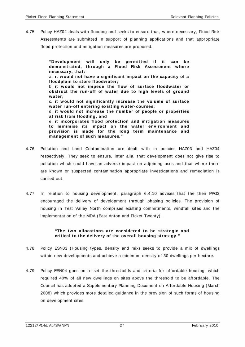
4.75 Policy HAZ02 deals with flooding and seeks to ensure that, where necessary, Flood Risk
Assessments are submitted in support of planning applications and that appropriate
flood protection and mitigation measures are proposed.
“Development will only be permitted if it can be demonstrated, through a Flood Risk Assessment where necessary, that: a. it would not have a significant impact on the capacity of a floodplain to store floodwater; b. it would not impede the flow of surface floodwater or obstruct the run-off of water due to high levels of ground water; c. it would not significantly increase the volume of surface water run-off entering existing water-courses; d. it would not increase the number of people or properties at risk from flooding; and e. it incorporates flood protection and mitigation measures to minimise its impact on the water environment and provision is made for the long term maintenance and management of such measures.”
4.76 Pollution and Land Contamination are dealt with in policies HAZ03 and HAZ04
respectively. They seek to ensure, inter alia, that development does not give rise to
pollution which could have an adverse impact on adjoining uses and that where there
are known or suspected contamination appropriate investigations and remediation is
carried out.
4.77 In relation to housing development, paragraph 6.4.10 advises that the then PPG3
encouraged the delivery of development through phasing policies. The provision of
housing in Test Valley North comprises existing commitments, windfall sites and the
implementation of the MDA (East Anton and Picket Twenty).
“The two allocations are considered to be strategic and critical to the delivery of the overall housing strategy.”
4.78 Policy ESN03 (Housing types, density and mix) seeks to provide a mix of dwellings
within new developments and achieve a minimum density of 30 dwellings per hectare.
4.79 Policy ESN04 goes on to set the thresholds and criteria for affordable housing, which
required 40% of all new dwellings on sites above the threshold to be affordable. The
Council has adopted a Supplementary Planning Document on Affordable Housing (March
2008) which provides more detailed guidance in the provision of such forms of housing
on development sites.
12212/P14d/A5/SA/NPN 27 February 2010

Picket Piece Planning Statement Relevant Planning Policies
4.80 Policy ESN20 (New local shops and local community facilities) permits the provision of
these uses within new development where there would:
“be no adverse impact on the character of the area of the amenity of nearby residents”.
4.81 In relation to the provision of open space on new housing development, policy ESN22
(Public recreation open space provision) states:
“New housing development where there is a net increase in dwellings will be permitted subject to:
a. The provision of open space to a standard of at least 2.8ha per 1,000 population comprising: Sport’s grounds / formal recreation 1.0ha Parkland 0.4ha Informal recreation areas 0.8ha Children’s play space 0.6ha
As net areas of usable open space, excluding access, parking, ancillary buildings, landscaping and safety margins sufficient to avoid the need for visually intrusive fencing;
b. the layout out and equipping of the open space to a high standard at an early stage in the development; and c. arrangements for the long term maintenance for the open space having been made.”
4.82 Policy ESN30 sets out that development should contribute to infrastructure and
community facilities. The Council has an adopted Infrastructure and Developer
Contributions SPD (February 2009) which provides more detailed guidance on how
contributions under S106 of the 1990 Act (as amended) will be negotiated in line with
Circular 5/05.
4.83 Policies TRA01 (Traffic generating development), TRA02 (Parking Standards), TRA 04
(Financial contributions to transport infrastructure), TRA 05 (Safe Access), TRA 06 (Safe
Layouts) and TRA 09 (Impact on the highway network) have all been considered fully as
part of the submitted Traffic Impact Assessment. These policies seeks to, inter alia,
ensure that new development do not have an adverse impact on pedestrian, cycle or
public transport users, seeks to promote the use of modes of transport other than the
private car and ensures that the new development his acceptable in access and layout
terms.
12212/P14d/A5/SA/NPN 28 February 2010
Picket Piece Planning Statement Relevant Planning Policies
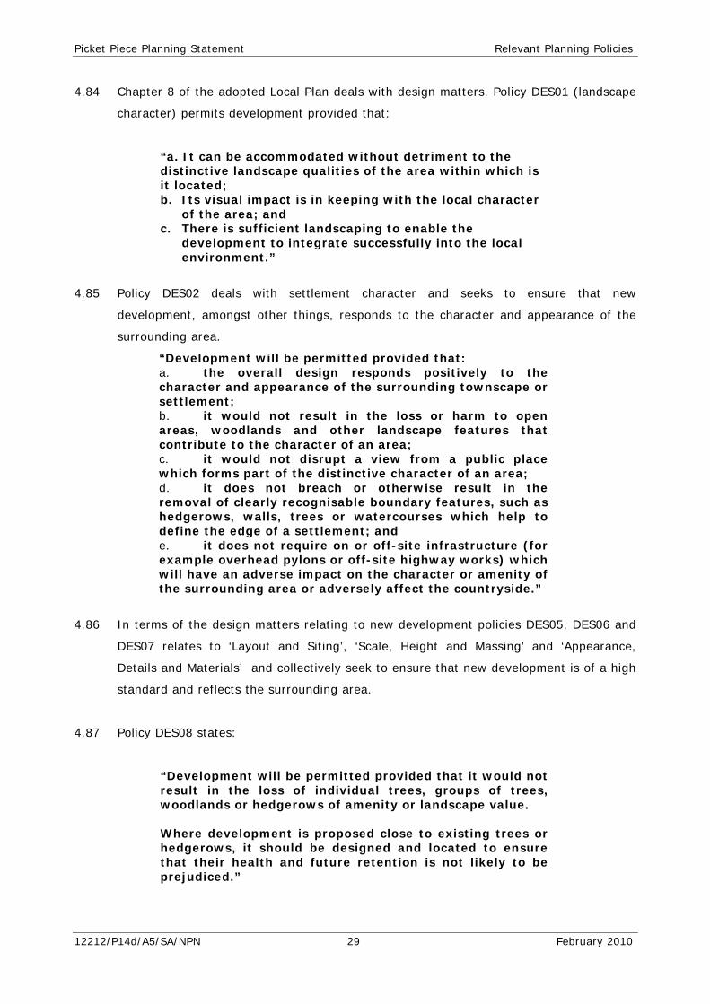
4.84 Chapter 8 of the adopted Local Plan deals with design matters. Policy DES01 (landscape
character) permits development provided that:
“a. It can be accommodated without detriment to the distinctive landscape qualities of the area within which is it located; b. Its visual impact is in keeping with the local character
of the area; and c. There is sufficient landscaping to enable the
development to integrate successfully into the local environment.”
4.85 Policy DES02 deals with settlement character and seeks to ensure that new
development, amongst other things, responds to the character and appearance of the
surrounding area.
“Development will be permitted provided that: a. the overall design responds positively to the character and appearance of the surrounding townscape or settlement; b. it would not result in the loss or harm to open areas, woodlands and other landscape features that contribute to the character of an area; c. it would not disrupt a view from a public place which forms part of the distinctive character of an area; d. it does not breach or otherwise result in the removal of clearly recognisable boundary features, such as hedgerows, walls, trees or watercourses which help to define the edge of a settlement; and e. it does not require on or off-site infrastructure (for example overhead pylons or off-site highway works) which will have an adverse impact on the character or amenity of the surrounding area or adversely affect the countryside.”
4.86 In terms of the design matters relating to new development policies DES05, DES06 and
DES07 relates to ‘Layout and Siting’, ‘Scale, Height and Massing’ and ‘Appearance,
Details and Materials’ and collectively seek to ensure that new development is of a high
standard and reflects the surrounding area.
4.87 Policy DES08 states:
“Development will be permitted provided that it would not result in the loss of individual trees, groups of trees, woodlands or hedgerows of amenity or landscape value.
Where development is proposed close to existing trees or
hedgerows, it should be designed and located to ensure that their health and future retention is not likely to be prejudiced.”
12212/P14d/A5/SA/NPN 29 February 2010

Picket Piece Planning Statement Relevant Planning Policies
4.88 A similar approach is required in relation to wildlife and amenity features (Policy
DES09).
4.89 Policy DES10 promotes new hard and soft landscaping within new developments, in
conjunction with the retention of existing features.
4.90 Policy AME01 (Privacy and Private Open Space) advises that development will be
permitted if:
a. “it provides for the privacy and amenity of its occupants and those of neighbouring properties; and b. in the case of residential development, it provides for private open space in the form of gardens or communal open spaces appropriate to the needs of the intended occupants taking account of topography, location and character.”
4.91 Policy AME02 requires all new development to ensure satisfactory provision of daylight
and sunlight to new and existing properties.
4.92 Policy AND03 proposes an extension to the Walworth Estate in respect of employment
uses (Class B1(b), Class B1(c) Class B2 and Class B8. It is stated that development
should be designed to respect its surroundings particularly with regard to Picket Piece.
4.93 Paragraph 10.5.3 states that:
“The layout of the development and the design and location of any new buildings will need to take account of the existing development at Picket Piece and that area's potential for further residential development. Buildings should be set back from the eastern boundary, by approximately 35 metres and be orientated so that service areas are not facing housing. Their design and siting should also be such that any noise generated is minimised. That part of the site rising southwards to Ox Drove is sensitive in visual terms when viewed from the south and longer distance views from the north. Buildings here should respect those views and their height will need to be restricted.”
EMERGING LOCAL DEVELOPMENT FRAMEWORK: CORE STRATEGY
4.94 Test Valley Borough Council published their Pre-Submission Draft Core Strategy in
October 2008. At an exploratory meeting on 1st May 2009, the Inspector advised that
the Pre-submission draft was likely to be found unsound for a number of reasons,
though not in relation to the proposed strategic housing land allocation at Picket Piece.
12212/P14d/A5/SA/NPN 30 February 2010
Picket Piece Planning Statement Relevant Planning Policies
It is considered important to note that the Pre-submission draft of the Core Strategy
was premised on 5,000 homes being required by the draft South East Plan in Northern
Test Valley yet the adopted RSS actually provides for 6,100 homes within the period
2006-26.
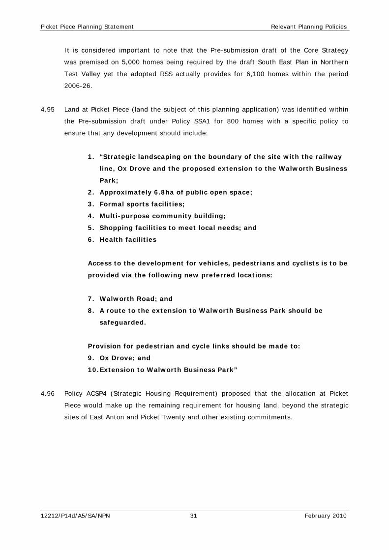
4.95 Land at Picket Piece (land the subject of this planning application) was identified within
the Pre-submission draft under Policy SSA1 for 800 homes with a specific policy to
ensure that any development should include:
1. “Strategic landscaping on the boundary of the site with the railway
line, Ox Drove and the proposed extension to the Walworth Business
Park;
2. Approximately 6.8ha of public open space;
3. Formal sports facilities;
4. Multi-purpose community building;
5. Shopping facilities to meet local needs; and
6. Health facilities
Access to the development for vehicles, pedestrians and cyclists is to be
provided via the following new preferred locations:
7. Walworth Road; and
8. A route to the extension to Walworth Business Park should be
safeguarded.
Provision for pedestrian and cycle links should be made to:
9. Ox Drove; and
10. Extension to Walworth Business Park”
4.96 Policy ACSP4 (Strategic Housing Requirement) proposed that the allocation at Picket
Piece would make up the remaining requirement for housing land, beyond the strategic
sites of East Anton and Picket Twenty and other existing commitments.
12212/P14d/A5/SA/NPN 31 February 2010
Picket Piece Planning Statement Planning Issues
5.0 PLANNING ISSUES
In developing their proposals for this development the Applicant has sought to ensure
that the development complies with all relevant national, regional and local planning
policy guidance.
This section sets out the main planning issues associated with the proposed
development and provides an explanation of how those issues are addressed to comply
with the aims, objectives and requirements of the relevant policies.
5.1 The Principle of Development
5.1.1 The site lies within the open countryside, to the rear of an area defined within the Local
Plan for frontage infill development. There is a long planning history in relation to this
site, specifically concerning its status within the development plan, as described at
Section 3.0. The consideration of the site for residential development has therefore
been undertaken over a considerable period of time, most recently during the
preparation of the Local Development Framework, but also during the Local Plan Public
Inquiry into the now adopted Local Plan where the Inspector identified the site as being
suitable for such a development.
5.1.2 The omission of the site from the Adopted Local Plan, contrary to the recommendation
of the Inspector, was primarily due to the concerns of the Council regarding the
deliverability of the development given the fragmented nature of the site in terms of the
number of landowners involved; and did not relate to the suitability of the site.
5.1.3 Whilst the Core Strategy has been withdrawn and does not form part of the
Development Plan, the level of housing required flows from the Regional Spatial
Strategy and it will, therefore, be necessary for Test Valley Borough Council to identify
sufficient land to meet those requirements, which have been increased to 305 per
annum (for Northern Test Valley) within the adopted South East Plan, which of course is
now part of the Development Plan.
Housing Land Supply
5.1.4 In October 2009 Test Valley Borough published a draft Strategic Housing Land
Availability Assessment (SHLAA) which set out:
12212/P14d/A5/SA/NPN 32 February 2010
Picket Piece Planning Statement Planning Issues
• The housing commitments within the Borough (i.e. those sites which have
planning permission but where the development is not yet complete);
• The sites where there is no extant planning permission but where there is a
planning policy presumption in favour of development;
• Site which have been put forward as having the potential for development
but would require a change in planning policy
5.1.5 The final version of the SHLAA (following public consultation) is due to be published at
the end of January 2010 but was not available at the time of writing.
5.1.6 The draft SHLAA identifies that over the 3 year period from 2006 until 2009 a total of
379 dwellings were completed within Northern Test Valley, which is only slightly higher
in total than the annual requirement: and represents a shortfall of 536 dwellings over a
three year period. This means that the annualised residual requirement stands at 336
over the remaining 17 years of the period to 2026. However, it is our view, supported
by Policy H2 of the RSS, which advises that backlog of unmet housing need should be
addressed in the first 10 years of the Plan period i.e. by 2016, that the shortfall of 536
dwellings should be met over the next 5 years. Accordingly, if one adds the shortfall to
the annual residual housing requirement spread over 5 years, this increases the
requirement to 412 dwellings per annum.
5.1.7 The Council’s Annual Monitoring Report forecasts a much improved rate of housing
delivery over the next few years primarily in relation to construction works on the two
Major Development Areas of East Anton and Picket Twenty. Whilst it is acknowledged
that outline planning permission has been granted for 1,200 dwellings at Picket Twenty
and 2,500 dwellings at East Anton with reserved matters applications granted for some
phases of both schemes, work has so far only commenced at East Anton. There has
been no significant start at Picket Twenty and there is no indication that works are to
commence at any time soon. It is estimated that the Council is reliant on the two MDAs
for around 75% of existing housing land supply over the RSS plan period to 2026.
5.1.8 Having reviewed the responses received to the draft SHLAA, the Local Planning
Authority has sought to establish their 5 year housing land supply position in
accordance with paragraph 54 of PPS3. It is understood that the Council’s analysis of
the situation is that they have 5.8 years supply in Northern Test Valley with existing
commitments and identified sites (though this takes no account of the shortfall in 2006-
09); though this falls to 5 years when taking the revised annual requirement of 412
dwellings.
12212/P14d/A5/SA/NPN 33 February 2010
Picket Piece Planning Statement Planning Issues
5.1.9 The applicant has undertaken a review of the Council’s assumptions set out within the
SHLAA and carried forward to their 5 year housing land supply calculations and it is
considered that certain sites should not be included as they do not meet the test of
deliverability set out within PPS3. Those sites where there is a difference of opinion
between the applicant and the Local Planning Authority are set out below:
5.1.10 East Anton – Outline planning permission has been granted for 2,500 dwellings on this
major development site on the edge of Andover. Work has commenced and is ongoing
on site: however, we would question the estimated rate of delivery of the housing over
the 5 year period. The Local Plan Inspectors Report (September 2005) considered the
rate of delivery suggested by the promoters of the East Anton site and expressed
concerns regarding the high level of delivery being proposed. Given the current
economic climate and the relatively low level of housing completions both historically in
Northern Test Valley (an average of 126 dwellings per annum) and on the East Anton
site itself it is considered that the suggested completion rate of 200 dwellings per
annum is overly optimistic and should be reduced to a more realistic 150 per annum as
we understand there are three developers active on the site. It is considered reasonable
to assume that each can deliver around 50 dwellings per calendar year – one dwelling
completion per week on average.
Picket Twenty – In addition, the SHLAA housing trajectory proposes the completion of
50 dwellings on Picket Twenty in 2011/12, but with no commencement on site this must
be considered optimistic and it is considered more robust to defer the commencement
of development for at least a 12 month period, resulting in 100 fewer dwellings on
Picket Twenty by 2014/15 i.e. 250 overall within the five year period.
5.1.11 The SHLAA document also considers a number of sites within Northern Test Valley
which lie within an area where the principle of residential development would be
considered acceptable in planning policy terms. There are, however, a number of sites
identified within the Council’s document which we do not consider meet the tests of
deliverability as set out within PPS3. These sites, and the reasons for our concerns, are
set out below.
a) 57 & 59 Rooksby Road – the site was the subject of a formal planning
application which was refused in October 2007 for a number of reasons including
that the development of 21 units would have a detrimental impact on the
character of the area which is characterised by low density development.
12212/P14d/A5/SA/NPN 34 February 2010
Picket Piece Planning Statement Planning Issues
b) Children’s Playgroup, Cricketers Way – This site is currently used as a pre-
school which is due to be relocated to Andover Town Centre in 2010. However,
at present there is proposed replacement pre-school facility and it is considered
that this site is not available for development.
c) East Anton and Picket Twenty Density Increases – The density increases
would not result in the physical extension of the site but could potentially result
in the need for taller buildings to be provided, which could have a detrimental
visual impact on the area. In addition to EIA and other procedural implications,
the impact of increased housing numbers on infrastructure and services will also
need to be considered, including impact on highway junctions and traffic
management matters. The impact upon the provision and amount of open space
and the provision of education will also need to be considered as any increase in
housing numbers will inevitably require an increase in the amount of open space
which will affect the overall master plan for the development. It is considered
that the density increases at both sites have yet to be demonstrated as suitable
for the numbers included within the Council’s housing land supply and would not
increase supply in the 5 year period.
d) Easton Anton Secondary School – The outline planning permission for East
Anton includes a site reserved for a secondary school. Hampshire County Council
has yet to confirm whether the site is required. The site is not therefore
available at present and as such should not be included within the five year land
supply.
e) George Yard / Black Swan – We understand that whilst the site it mainly
owned by Test Valley Borough Council, parts of the site are under private
ownership and as such a Compulsory Purchase Order may be required to deliver
the redevelopment of the site. Furthermore, the site is currently used for car
parking and any redevelopment of the site would result in the loss of car parking
for the town centre uses. We would therefore question whether this site is
suitable for development.
f) Land at Former Shepherds Spring Schools and Land at Roman Way
School – These site form parcels of land which are considered by Hampshire
County Council as surplus to requirements. Both sites forms areas of land
classified as school playing fields and as such their loss would need to be
considered against the guidance within PPG17.
12212/P14d/A5/SA/NPN 35 February 2010
Picket Piece Planning Statement Planning Issues
g) Hillside Villas – We question whether the shape of the site would allow for a
high quality design providing adequate amenity space and living conditions for
future residents and given the proximity of the watercourses we would question
whether matters in relation to flooding have been fully considered when
assessing the site as deliverable.
Conclusions on Five Year Housing Land Supply
5.1.12 In conclusion, there are a number of sites which are considered to fail the tests of
deliverability as set out within PPS3 and those site should not, therefore, be counted
within Test Valley Borough Council’s housing land supply. The omission of those sites
outlined above would result the Local Planning Authority having 3.9 years supply of
housing land and a shortfall of 439 units over the 5 year period starting from April
2009.
5.1.13 Rolling this forward to take account of completions from the beginning of April 2009 to
the end of December 2009 will further demonstrate the inadequacy of the Council’s land
supply position. Whatever completions have occurred in the period April to December
2009 will have had an equal effect on the supply and requirement sides of the equation.
Thus the change in the 5 year supply since 1st April 2009 can be assessed by comparing
the number of new permissions given to the additional requirement (9 months of the
RSS figure), thus:
Net new dwellings added to the supply: +23
less:
Dwellings added to the requirement (75% of 412pa requirement):-309
equals:
Change in the 5 year supply April – December 2009: -286
This would turn our assessed deficit at March 2009 of 439 dwellings into a deficit of 725
dwellings in December 2009 and further demonstrates the continued contraction of the
Council’s housing land supply with the need to bring forward sites to contribute to the
delivery of housing.
5.1.14 Given the RSS requirements, the relatively slow delivery of housing over the past three
years, and the sites identified within the SHLAA which are not considered by the
applicant to be deliverable, it is considered that there will continue to be a requirement
for a strategic site to be identified within the Core Strategy.
12212/P14d/A5/SA/NPN 36 February 2010
Picket Piece Planning Statement Planning Issues
5.1.15 The location of the application site has, on numerous occasions, been confirmed as
suitable for residential development and its omission from previous development plan
documents has only related to concerns regarding the deliverability of the site. This
planning application seeks permission only for land within the control of the applicant.
5.1.16 Paragraph 71 of PPS3 advises that where LPAs cannot demonstrate an up-to-date five
year supply of deliverable sites, for example, where LDDs have not been reviewed to
take into account policies in PPS3 or there is less than five years supply of deliverable
sites, they should consider favourably planning applications for housing, having regard
to the policies in PPS3 including the considerations in Paragraph 69.
5.1.17 Test Valley BC has not reviewed its policies to take account of PPS3, which was
published in December 2006 following the adoption of the Local Plan in June 2006, and
it is considered that the Council does not benefit from a 5 year housing land supply of
deliverable sites in accordance with Paragraph 54 of PPS3. On this basis PPS3 directs
that the Council should consider favourably this application in accordance with
Paragraph 69 of PPS3. The DCLG guidance on Demonstrating a 5 Year Supply of
Deliverable Sites advises that even where they can demonstrate an up to date 5-year
supply of deliverable sites, they should:
“Consider planning applications having regard to PPS3 (in particular paragraph 69), Development Plan policies and other material considerations. In areas with significant demand and need for housing Local Planning Authorities should not necessarily treat the 5-year housing provision figures as a ceiling which cannot be exceeded.” (emphasis added)
5.1.18 It is considered that the Council’s five year land supply in the northern part of the
Borough is wholly dependent on two key sites, East Anton and Picket Twenty, and with
the suggestion of further development through greater densities on these sites, the
Council is arguably even more exposed to the performance and delivery of such sites –
this is not in our view a flexible and responsive land supply position as is required by
PPS3.
5.1.19 Accordingly, the nature and circumstances of supply are such that the Council’s five
year land supply is fragile and heavily dependent on the delivery of two key sites. The
Council must have due regard to the trajectory and supply of housing land over the
whole plan period in order to achieve a flexible and responsive housing land supply for
at least 15 years from the point of adoption of LDDs. Indeed, Paragraph 55 of PPS3
requires that LPAs should also identify a further supply of specific developable sites for
12212/P14d/A5/SA/NPN 37 February 2010
Picket Piece Planning Statement Planning Issues
years 6-10, and, where possible, for years 11-15. Even if one were to accept (which we
do not) the Council’s position of 5.8 years supply (or 5.1 years assuming a requirement
of 412dpa), such supply is only marginally above the 5 year requirement and the
delivery of Picket Piece would make an important contribution to both 5 year and 6-10
year housing land supply.
5.1.20 Notwithstanding this assessment of the Northern Test Valley area, regard should be had
to the need to consider Test Valley Borough as a whole. RSS Policy H1 requires LPAs to
ensure delivery of district/Borough wide housing requirements, i.e. 501 dwellings per
annum or 10,020 over the plan period. Paragraph 7.9 of the RSS notes that LPAs should
ensure clear arrangements for managing and monitoring the delivery of housing
provision for sub-regional areas together with the trajectory for the district as a whole.
Using the Council’s own SHLAA data it is estimated that there is a Southern Test Valley
5 year housing land supply of 4.36 years as at 1st April 2009. Paragraph 52 of PPS3
states that the Government’s objective is to ensure that the planning system delivers a
flexible and responsive supply of land. Flexibility is therefore at the heart of national
policy on housing, as set out in PPS3. Whilst the RSS may disaggregate the housing
requirements within Test Valley, PPS3 does not make such a distinction in policy terms.
Thus, when examining either Northern Test Valley, Southern Test Valley or the whole
Borough, the Council’s housing land supply is considered to be deficient in terms of the
5 year land supply requirement.
Suitability of Picket Piece
5.1.21 We do not consider that the delivery of development at Picket Piece would prejudice the
preparation of the Core Strategy, including the identification of strategic sites for
development, nor would it harm wider policy objectives as referred to in paragraph 69
of PPS3. The site has been proposed for strategic allocation by the Council in the now
withdrawn Core Strategy where Picket Piece was proposed for 800 dwellings and the
site compares favourably in relation to all other sites in the northern part of Test Valley.
5.1.22 In September 2005, following the Local Plan Public Inquiry, the Inspectors Report
confirmed in relation to Picket Piece that:
“It seems to us that the area already has the semi urban character of an existing mainly residential community on the edge of Andover...we therefore have no hesitation in concluding that Picket Piece has the potential for a planned extension to the existing urban area.”
12212/P14d/A5/SA/NPN 38 February 2010
Picket Piece Planning Statement Planning Issues
We consider that demonstrating the deliverability of Picket Piece is best served through
the preparation and submission of a planning application and Environmental Impact
Assessment.
5.1.23 In accordance with Paragraph 69 of PPS3, it is considered that the development
proposed and set out in more detail in the Design and Access Statement is of high
quality, with a good mix of housing in accordance with RSS Policy H2, and Local Plan
Policy ESN03. The site has been used efficiently in terms of land use, balancing the
spatial context to the site against the objective of Paragraph 40 of PPS3, RSS Policy and
Local Plan Policy ESN03.
5.1.24 The suitability of the site for housing as been demonstrated by the previous Local Plan
Inquiry and though the Environmental Impact Assessment accompanying this planning
application, and the development is in line with planning for housing objectives,
reflecting both need and demand as well as the emerging spatial vision for the area –
as confirmed by the recently withdrawn Core Strategy – which demonstrates without
doubt that the site is considered suitable for development. The site is located close to,
and will provide through a new local centre, a range of community facilities, with good
access to jobs, key services and infrastructure, especially through enhanced public
transport provision in accordance with paragraph 36 of PPS3. We consider that the
above justification warrants the favourable consideration of development within an area
of countryside subject to the normal policy of development restraint (Local Plan Policy
SET03).
Deliverability
5.1.25 The land subject to the planning application is either under ownership to Wates
Developments Ltd or under the control of the applicant via an option agreement with
the relevant landowners (many of them local residents of Picket Piece) to promote
residential development of the site. There is therefore no obstruction to the delivery of
this site for development. All of the option agreements envisage and facilitate a
comprehensive development of the site. There are three small parcels of land between
Walworth Road and Ox Drove (shown with a dotted red line on the master plan), which
Wates anticipate have the potential to come forward for development at a later stage
and therefore the Environmental Impact Assessment has assessed these areas as part
of an overall development of up to 800 homes, including two substantial development
areas north of Walworth Road (also shown on the master plan). The Design and Access
Statement considers the overall development as well as that proposed for this planning
12212/P14d/A5/SA/NPN 39 February 2010
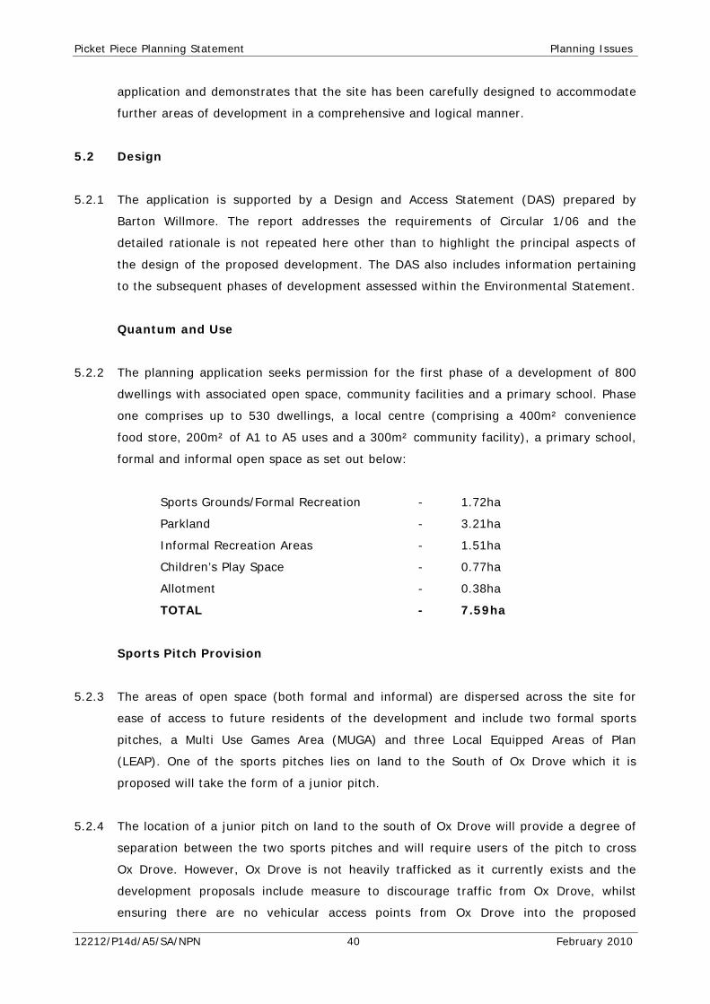
Picket Piece Planning Statement Planning Issues
application and demonstrates that the site has been carefully designed to accommodate
further areas of development in a comprehensive and logical manner.
5.2 Design
5.2.1 The application is supported by a Design and Access Statement (DAS) prepared by
Barton Willmore. The report addresses the requirements of Circular 1/06 and the
detailed rationale is not repeated here other than to highlight the principal aspects of
the design of the proposed development. The DAS also includes information pertaining
to the subsequent phases of development assessed within the Environmental Statement.
Quantum and Use
5.2.2 The planning application seeks permission for the first phase of a development of 800
dwellings with associated open space, community facilities and a primary school. Phase
one comprises up to 530 dwellings, a local centre (comprising a 400m² convenience
food store, 200m² of A1 to A5 uses and a 300m² community facility), a primary school,
formal and informal open space as set out below:
Sports Grounds/Formal Recreation - 1.72ha
Parkland - 3.21ha
Informal Recreation Areas - 1.51ha
Children’s Play Space - 0.77ha
Allotment - 0.38ha
TOTAL - 7.59ha
Sports Pitch Provision
5.2.3 The areas of open space (both formal and informal) are dispersed across the site for
ease of access to future residents of the development and include two formal sports
pitches, a Multi Use Games Area (MUGA) and three Local Equipped Areas of Plan
(LEAP). One of the sports pitches lies on land to the South of Ox Drove which it is
proposed will take the form of a junior pitch.
5.2.4 The location of a junior pitch on land to the south of Ox Drove will provide a degree of
separation between the two sports pitches and will require users of the pitch to cross
Ox Drove. However, Ox Drove is not heavily trafficked as it currently exists and the
development proposals include measure to discourage traffic from Ox Drove, whilst
ensuring there are no vehicular access points from Ox Drove into the proposed
12212/P14d/A5/SA/NPN 40 February 2010
Picket Piece Planning Statement Planning Issues
development. The pitch south of Ox Drove is situated approximately 150m from the
proposed sports pavilion, easy walking distance from the changing rooms, with 90m of
this distance achieved by simply walking along the edge of the northern sports pitch. A
pedestrian friendly crossing point will be provided over Ox Drove. The junior pitch south
of Ox Drove will be set within an area of ground modelling to create the required Sport
England gradient, and this will serve to create an attractive backdrop for spectators to
watch matches on the pitch, creating a grassed embankment on the southern side of
the pitch. This creates added value to the development and existing residents by
delivering a unique facility which is suitably located to both minimise disturbance to
residents but provide an effective use of land in easy walking distance of the proposed
development for formal sports provision.
5.2.5 It is intended that the junior sports pitch will located adjacent to an area of informal
open space which could includes elements such as a skate park and is surrounded by a
circular walkway for informal recreational uses, both of which will provide surveillance
of users of the pitch, as will the existing and proposed residential dwellings to the north
and west. As such we consider that the proposed open space provision in terms of the
range and type of provision, its quantity and its disposition, is functional, attractive and
acceptable in planning terms and represents a real asset to the proposed development
and existing community.
5.2.6 The amount of open space, its location and the form within which it is proposed (i.e.
the mix of types) is in accordance with RSS Policy CC8, Local Plan Policy ESN22 and the
provision of community facilities complies with the provisions of Local Plan Policy
ESN30.
5.2.7 The proposed open space meets the requirement of the withdrawn Core Strategy Policy
for Picket Piece in terms of quantum of space, plus sports pitch provision, a multi-
purpose community building and shopping facilities to meet local needs. Health facilities
are not proposed as Hampshire Primary Care Trust has not stated that it will be seeking
the provision of a health facility on site. A financial contribution for off-site GP surgery
improvements is most likely but this needs formal agreement. The community building
is capable of being used as a satellite GP surgery if required.
Retail Assessment
5.2.8 A Retail Assessment report has been submitted in support of the planning application.
The report demonstrates the following:
12212/P14d/A5/SA/NPN 41 February 2010
Picket Piece Planning Statement Planning Issues
(i) There is policy support for the provision of retail facilities at expanded
communities such as Picket Piece.
(ii) There is a clearly defined quantitative and qualitative need for the indicative
amount of retail floorspace proposed.
(iii) The amount of retail floorspace proposed is well within the suggested parameters
for the amount of floorspace which could be supported by the existing and
proposed development.
(iv) The scale of retail floorspace is consistent with the role and function of Picket
Piece and commensurate with addressing the needs of its existing and new
residents. Similarly, the quantum of retailing proposed can be supported by the
new residents of the development, without needing to draw existing retail
expenditure from other centres. It is self sustaining in expenditure terms, and
will not therefore compete to a material extent with or have an adverse impact
on retail facilities in existing centres. The local centre will accord with Local Plan
Policy ESN20.
Layout
5.2.9 The master plan and illustrative layout submitted provides for a flexible layout, taking
full account of the location of the site interspersed with existing residential and
commercial development. The overarching principles for the site have evolved in
response to the contextual analysis within the DAS. As such, the principles for the
development of the site are set out below:
• Comply with policy guidance and, in particular, local plan policy;
• Integrate the site with the adjoining areas;
• Provide a landscape open space network;
• Create a development which minimizes the need for car journeys and
encourages walking and cycling;
• Adopt an environmentally sensitive approach minimizing the impact on
surrounding areas;
• Provide a distinctive high quality in terms of building, urban form and spaces,
which draws on the traditions of the area; and
• Create a safe and attractive place, which fosters a sense of community.
12212/P14d/A5/SA/NPN 42 February 2010
Picket Piece Planning Statement Planning Issues
5.2.10 A sensitive approach to the layout and siting of development is adopted in accordance
with the objectives of Local Plan Policy DES05, including the retention of green space,
fitting in with the landscape structure and minimizing tree and hedge losses and
ecological impact. The defining characteristic which has driven the layout of the
proposed development is the retention of Important and other species rich hedgerows.
The development will have a strong sense of place promoted by the use of references
from distinctive places in the area. Areas of public open spaces and the local centre will
be created for the benefit of new residents and the existing community. The
development will provide a mixture of house types and tenures meeting the needs of
the local community. The development will ensure good design (an attractive, durable
and adaptable place) in accordance with Paragraph 33 of PPS1.
5.2.11 The proposed development is founded on a key access loop – the main street, which
runs on an east west axis in parallel to Walworth Road, connecting to the existing road
at two points, one at the eastern end of the site and the other towards the western end
of the site. This will enable the development to be served by public transport on a loop
which uses Walworth Road to connect with the new main street. A Local Centre,
including a one form entry primary school is proposed within the site, at a position
accessible to Walworth Road and the Walworth Estate as well as centrally located within
walking distance of new residents. This centre will contain a food store and other retail
units plus a community building for a variety of uses.
5.2.12 A sports pavilion and Multi-Use Games Area (MUGA) is to be provided along with
children’s play areas and formal sports pitches. These facilities and key route form the
backbone of the new community, which will then be divided into a series of residential
character areas. A key aim of the Master Plan is to create a development with a distinct
identity. Therefore based on the location, density and the use of the units, five key character
zones have been identified each of which has a specific role in responding to landscape, or key
routes within the development. The spaces, which meet the objectives of Local Plan Policy DES10,
are described in further visual and written detail in the DAS, and are summarised as follows:
• High Street Frontage:
• Main Street Frontage;
• Green Lane Frontage;
• Back Streets; and
• Mews.
12212/P14d/A5/SA/NPN 43 February 2010

Picket Piece Planning Statement Planning Issues
Walworth Industrial Estate
5.2.13 With respect to the boundary facing the proposed Walworth Estate extension, we
consider that appropriate regard has been made to this relationship, with development
proposed to front the western boundary of the site, incorporating a 10m buffer within
the site to the dwelling frontages. It should be noted that the Local Plan allocation for
the Industrial Estate, policy AND03.2 advises that a landscape buffer 15 metres wide on
the eastern boundary of the site is to be provided and the text of paragraph 10.5.3
states:
“The layout of the development and the design and location of any new buildings will need to take account of the existing development at Picket Piece and that area's potential for further residential development. Buildings should be set back from the eastern boundary, by approximately 35 metres and be orientated so that service areas are not facing housing. Their design and siting should also be such that any noise generated is minimised. That part of the site rising southwards to Ox Drove is sensitive in visual terms when viewed from the south and longer distance views from the north. Buildings here should respect those views and their height will need to be restricted.”
5.2.14 It is considered that the combination of measures outlined above, together with our
proposal would result in commercial and residential buildings at least 45 metres apart,
with no servicing areas fronting housing and a substantial landscaped buffer across the
boundary of some 20 metres in depth. As such an adequate relationship would exist
between residential and commercial development in this context. Matters of privacy and
open space and daylight and sunlight considerations in respect of the illustrative layout
and design principles have been addressed as part of the Design and Access Statement
in accordance with Local Plan Policies AME01 and AME02.
Scale
5.2.15 The heights of the buildings in the Application Site will range between 2 and 3 storeys.
The accompanying Environmental Statement Parameter Plans define the envelope for
storey heights whilst the illustrative master plan has been developed to allow for
flexibility at the detailed design stages. All properties will be within the parameters that
the plans have established. Scale parameters are contained within the DAS and the
scale height and massing reflects the objectives of Local Plan Policy DES06.
12212/P14d/A5/SA/NPN 44 February 2010
Picket Piece Planning Statement Planning Issues
Appearance
5.2.16 Whilst the appearance of the buildings is reserved for future consideration, the Design
and Access Statement contains information in respect of the potential design, materials
palette and influences from surrounding villages and towns. The overall design responds
positively to the character and appearance of the surrounding area in accordance with
Local Plan Policy DES02 criterion a, and Policy DES07. The architectural strategy for the
site establishes design principles for a variety of building types spread across the Site.
5.2.17 While there has to be a certain amount of coherence in the treatment of elevations so
that they respond to local distinctiveness, this should not suppress the expression of
their type and the use of modern technologies and materials. In considering the
principles for each use there are a number of factors which influence them all. These
include:
• Creating a sense of local distinctiveness which in terms of architectural
treatment recognises the building traditions and vernacular of the surrounding
villages. The local character analysis identifies potential urban form and
architectural references.
• The range of uses, density and height of development set out in the planning
parameters.
• The townscape opportunities and environmental context of the development;
and
• Providing sustainable buildings to reduce energy consumption and minimise
waste.
The overarching requirement is to produce high quality distinctive and sustainable
architecture and is set out in further detail in the DAS.
Landscape
5.2.18 The detailed landscape proposals will be considered at the reserved matters stage,
however the planting scheme will take account of the hedgerows to be retained and will
seek, in most places to reflect the hedgerow species prevalent within the area. The
landscape strategy for the site is included within the appendices to the landscape
chapter of the Environmental Statement.
5.2.19 The development will accord with the objectives of Local Plan Policy DES01 (Landscape
Character) in accommodating the new homes without detriment to the distinctive
landscape qualities of the area and ensuring sufficient landscaping to integrate the
12212/P14d/A5/SA/NPN 45 February 2010
Picket Piece Planning Statement Planning Issues
development into the local environment. The key features of the landscape structure
(which are discussed in greater detail in the DAS) are as follows:
• Proposed and retained hedgerows to feature wide grass verges forming edge
habitats, to soften the road infrastructure and enhance local biodiversity;
• Proposed linear ‘parkway’ aligning northern boundary to be enhanced with
additional native trees and a managed shrub under storey. The parkway will
enhance the local biodiversity in this area by incorporating informal pedestrian
routes through managed grassland areas;
• Semi-mature native tree planting within hedgerows will increase opportunities
for extending ecological corridors at tree canopy level. Such methods will be
introduced where gaps between hedgerows allow roads or paths to pass
through;
• Where necessary, non-native hedgerow trees will be phased out and replaced
with appropriate native, locally appropriate species;
• Avenue planting forms a transition from informal street planting to ‘village’
street planting and will feature large, native trees set within managed shrub and
grass landscaping;
• Informal street planting will feature medium native trees ideally suited for
urbanised planting, which will also contribute to the overall vegetative
framework associated with the landscape in the wider context;
• Proposed ‘domestic’ residential planting including trimmed hedgerows and shrub
planting creating separation between existing and proposed properties;
• Naturalistic play areas within informal open spaces, featuring retained and
proposed vegetation including managed hedgerows, grassland mosaics and scrub
planting to improve biodiversity and blending ecological benefi ts with
educational appreciation of nature.
5.3 Landscape and Visual Appraisal
5.3.1 There is a strong framework of hedgerows and tree belts along the eastern boundary of
the site, which forms a visual buffer between the built form within Picket Piece and the
open countryside. The site is also visually contained by a substantial hedgerow to the
north adjacent to the railway embankment, existing mature hedgerow trees within
hedgerows, a degraded framework of hedgerows within the southern portion of the site
and domestic planting within the gardens of existing residential properties.
12212/P14d/A5/SA/NPN 46 February 2010
Picket Piece Planning Statement Planning Issues
5.3.2 The existing structure of hedgerows, hedgerow trees and tree groups provides a strong
and attractive context for high quality design and ecological management as part of the
development.
5.3.3 In terms of the landscape character, at a national level, the site falls within the
Hampshire Downs, a landscape described as a strong rolling downland with scarps,
hilltops and valleys which have an open and exposed character. In contrast, the
sheltered downland valleys exhibit a strong framework of mixed-species hedgerows,
interspersed by numerous woodland blocks to give a strong sense of enclosure.
5.3.4 At a county level, the site is described as part of the Urban Area given its close
proximity to the urban edge of Andover, and the strong presence of residential and
commercial development in the area.
5.3.5 At a localised level within the Test Valley Borough, the Site lies within the Andover
Chalk Downland which forms part of the wider Chalk Downlands. The Andover Chalk
Downland is characterised by settlements resulting from ribbon development at Andover
and Picket Piece. The built-up edge of these settlements is recognised in the wider
landscape where urban fringe activities are visible from the open area of downland.
Historical land use influences the landscape as exhibited by the 19th century
parliamentary enclosure. This character is evident on the site where larger fields have
been subdivided to form smaller grazing paddocks for horses.
5.3.6 The landscape and visual appraisal within the Environmental Statement fully considers
the context of the Application Site and the impact of the development upon the
landscape.
5.3.7 The detailed visual appraisal demonstrates that the site is seen from a number of local
viewpoints. This includes open and partial views obtained from the roads and properties
which abut or are included within its boundaries. Open views are also obtained from
localised residential areas on Walworth Road and Ox Drove which pass through and to
the south of site. In these views, hedgerow character of the vegetation within the site
usually forms a prominent feature in the local landscape and accordingly has been
retained where possible. However, the remainder of the site is typically seen in the
context of the existing properties along Walworth Road and Ox Drove.
5.3.8 The visual appraisal confirms that longer distance views towards the site are restricted.
Again, topographical variation, and intervening vegetation within the landscape
12212/P14d/A5/SA/NPN 47 February 2010

Picket Piece Planning Statement Planning Issues
collectively screen and curtail views from the wider area. As a consequence, the site’s
contribution to the appearance of the landscape to the east of Andover is limited.
5.3.9 The results of the visual assessment demonstrate that a relatively limited number of
properties would experience moderate adverse effects in the longer term as a result of
the development. The properties that would be affected by the development are mostly
located in close proximity to the site. A number of residential properties at some
distance from the site would obtain long distance views towards the development.
However, the significance of the effects on these views is considered to be to minor to
negligible at worse due to their distance from the site and the filtering effect of
intervening vegetation and topography.
5.3.10 The views from the roads and railway which are local to the site would experience
minor or negligible adverse visual effects from the development at scheme completion,
and these include views from Walworth Road and Ox Drove. In these views, the
development would generally be seen in the context of the existing built up areas and
urban activities which occupy land surrounding the site. Longer distance views towards
from roads at a greater distance are generally curtailed by topography and existing
vegetation.
5.3.11 Although the land subject to development would change in character, the character of
the site is already influenced by the existing urban areas which surround it. As a
result, the change in character would move from a semi-urban or semi-rural character
to one which is more strongly urban. This represents a different order of effect to a
change from wholly rural to wholly urban. In addition, although the landscape
character of the site itself would change, the impact of this change on the character of
the surrounding landscape would be more limited.
5.3.12 The existing structure of hedgerows on the site would, for the most part, be retained,
and this would provide a robust landscape framework for the new development. The
reinforcement of the existing pattern of vegetation with new planting, which respects
species of local provenance, and the appropriate management of existing landscape
features, would ensure that the landscape structure of the area would be reflected
within the layout of the development. As a result, the pattern or “grain” of the
landscape would be retained and reflected within the mitigation proposals for the site.
5.3.13 A number of ecological enhancement opportunities would flow from the development
proposals. The planting proposals are anticipated to cover extensive areas, and would
consist of locally indigenous species. The introduction of new planting would enhance
12212/P14d/A5/SA/NPN 48 February 2010
Picket Piece Planning Statement Planning Issues
the biodiversity importance of these areas as well as providing a variety of tree age.
The master plan includes the creation of accessible green spaces and corridors
associated which will offer a significant contribution to recreational opportunities within
the community.
5.3.14 In summary, the development would result in a change in outlook for a number of
properties, roads and railways in the medium to long term. However, the provision of
substantial areas of structural landscape planting on the edges of the development
would provide visual “buffers” to views and provide nature conservation benefits that
extend along established green corridors. As the structural and informal street planting
matures, the development would become increasingly assimilated into the wider
landscape, and some of the local adverse visual effects would be reduced. In addition,
the landscape mitigation measures proposed would result in environmental and
benefits, and would enhance and reinforce local landscape character, local
distinctiveness and contribute a positively to the aims of a broader green network. The
site provides a high degree of visual containment from the surrounding landscape and
would respect the existing landscape structure and key on site features. Accordingly it
is considered that the site has a high capacity in landscape terms to accommodate
residential development in an acceptable manner.
5.3.15 On this basis the development accords with PPS1 and PPS7 in protecting and enhancing
the natural environment and character of the countryside, and in particular would not
adversely affect the setting of the North Wessex Downs AONB. The development
respects the local landscape character, in particular ensuring the retention of a large
proportion of the existing hedgerows and provides an appropriate landscape planting
strategy which will complement the development and the location of the site in
accordance with RSS Policies C3, C4 and C5 and Policies ENV07, DES01, DES08 and
DES10 of the Local Plan.
5.4 Ecology and Nature Conservation
5.4.1 The Application Site lies on Upper Chalk with the overall ecological zone of influence of
the development considered to extend across the site as a whole and constitutes all
areas of land which have the potential to be affected by the Proposed Development.
5.4.2 The majority of the site, as existing, comprises open extended gardens to the rear of
residential dwellings along Walworth Road and Ox Drove. The site is divided into parcels
both by land ownership (with associated fences) and with an extensive network of
hedgerows which include Elder, Hawthorn, Privet and buckthorn. There are a number of
12212/P14d/A5/SA/NPN 49 February 2010
Picket Piece Planning Statement Planning Issues
the hedgerows which are considered to be of significant importance and one of the
defining constraints of the site has been the desire to retain the hedgerows as much as
possible.
5.4.3 The primary ecological value of the site is within the well established and extensive
network of hedgerows, which are of Borough value and qualify as UK BAP priority
habitat. In addition to their innate wildlife value, they also support invertebrate, bird
and bat populations all assessed as of local or Borough value. Dormice also live within
these hedgerows in three discrete locations, and these are a receptor of county
importance, although their patchy distribution across the site indicates that this
population may not be viable even in the absence of development. The site, and
adjoining land, provides foraging for bats. During surveys five species of bat were
recorded, including the common Pipistrelle, Serotine, Noctule, Myotis and Long-Eared
Bats. These are generally the more common species and whilst a single roost was
identified, it will not be affected by the proposed development being within an existing
dwelling which is outside of the Application Site.
5.4.4 Retention of hedgerow habitat has been a primary focus of the design of the
development parameters and it has been possible to maintain a valuable network of
hedgerows on the site through a combination of retention and habitat creation. This
has enabled the majority of the existing wildlife value of the site to remain.
5.4.5 The overarching ecological mitigation measures comprise a site clearance strategy (for
the construction phase) and a hedgerow and grassland management plan (for the
operational phase). In particular, the hedges along the eastern boundary will be linked
to the wide hedgerow buffer that surrounds the public open space proposed in the
south-east (south of Ox Drove). This area will provide substantial scope for ecological
mitigation in the form of species rich grassland creation, bat foraging habitat and
dormice habitat. This habitat mitigation area south of Ox Drove is of a scale and
continuity to surrounding countryside which is of local significance to the site and has
the potential to achieve both an attractive recreational environment as well as a diverse
ecological habitat which will benefit a range of protected species as well as providing
for invertebrates.
5.4.6 The site clearance strategy will set out the seasonal timing, methodology and, where
appropriate, licences required for clearance of semi-natural habitat on the site. The key
receptors are bats, reptiles, nesting birds and dormice. Each of these has different
optimal seasons for clearance and requires slightly different treatments. A co-ordinated
12212/P14d/A5/SA/NPN 50 February 2010
Picket Piece Planning Statement Planning Issues
approach will therefore be critical to ensuring that adverse effects and legal offences
are avoided.
5.4.7 The hedgerow and grassland management plans will set out the techniques that will be
used to create habitats of ecological value and maintain that value in the long-term.
This includes measures such as rotational 3-5 yearly cutting for many of the hedgerows
and a programme of extensive management to promote natural regeneration within the
grasslands.
5.4.8 Other valuable receptors include slow-worms, along the London – Exeter railway line
embankment in the north of the subsequent development area and a bat roost,
immediately north of the application site (and therefore off-site). These receptors are
of county value and will be retained within the final scheme. Special mitigation
measures will be adopted in relation to the slow-worms and these include enhancement
of retained habitat and supervised site-clearance work in the appropriate season.
5.4.9 The residual effects of the development on ecology and nature conservation are
generally negligible although there will be some temporary adverse effects on
hedgerows and habitat connectivity during the construction period, before
compensatory habitat provision becomes established. One residual adverse effect of
site-scale significance will remain within the development and that is a residual loss of
semi-improved grassland. Substantial grassland retention and creation will take place,
and this residual effect is an unavoidable result of development over previously
undeveloped ground. The development will bring about beneficial effects through
eradication of invasive weeds and, if achieved, the long term retention of the currently
vulnerable dormouse population on the site as a result of species-specific habitat
enhancements. Long-term population monitoring for dormice will be undertaken in the
built scheme.
5.4.10 The proposed development is therefore considered to have incorporated a series of
measures in terms of its design, habitat retention and additional habitat creation to lead
to the realisation of opportunities to built-in nature conservation objectives in line with
PPS9. Where necessary the relevant European Protected Species Licences will be sought
from Natural England.
5.4.11 The development accords with the objective of RSS Policy CC1 in ensuring the
enhancement of the natural environment, Policies CC4, CC8 in providing green
infrastructure to enhance biodiversity, Policy NRM5 in providing no net loss of
12212/P14d/A5/SA/NPN 51 February 2010
Picket Piece Planning Statement Planning Issues
biodiversity, Policy NRM7 in terms of the protection of trees/woodland and Policies
ENV01, ENV05, DES02, DES08 and DES09 of the Local Plan.
5.6 Transport and Accessibility
5.6.1 A Transport Assessment Report (TAR), Residential Travel Plan (RTP) and Public
Transport Strategy (PTS) have been prepared by WSP, which all form part of the
appendices to the Environmental Statement. The transportation infrastructure being
planned is designed to promote the use of modes of transport other than the private
car.
5.6.2 There is an existing network of pedestrian and cycle facilities within the vicinity of the
site, including designed crossing at some of the main junctions between the site and
Andover Town Centre. These will be enhanced through the creation of additional
facilities for walking and cycling and by creating better links to some areas, such as the
Walworth Business Park. The provision of the local centre and its associated services
will also provide services for existing and proposed residents within a convenient
distance of their homes, in line with the guidance in PPG13.
5.6.3 There is a single existing bus service which operates two journeys a day to Picket Piece.
There are, however, other services which run in relative close proximity to the
Application Site and operate a more regular service. As part of the package of transport
measures proposed with the development a new bus service will be provided which will
serve the Application Site and the wider population of Picket Piece and will provide a 20
minute frequency to Andover Town Centre and an hourly service to Basingstoke. High
quality, fully accessible vehicles will be utilised which are attractive, convenient and
safe. New bus stops within the Application Site will ensure that all new residents are
within a five minute walk of the service.
5.6.4 Two new junctions will be created along Walworth Road to provide access into the
Application Site. These will take the form of roundabouts and will include footways to
provide safe pedestrian access into the site.
5.6.5 Transport modelling undertaken by WSP, in consultation with Hampshire County Council
Highways, has demonstrate that the proposals for development at Picket Piece are
acceptable from a transport perspective, the assessment having included the cumulative
impact of the developments at East Anton, Picket Twenty and Andover Airfield as well
as all phases of the proposed development (i.e. up to 800 dwellings).
12212/P14d/A5/SA/NPN 52 February 2010

Picket Piece Planning Statement Planning Issues
5.6.6 It has been demonstrated that in terms of location, the site is well positioned at the
east extent of the built up area of Andover. It has been demonstrated that all forms of
facilities (employment, schools, retail and leisure) expected to be required by residents
can currently be accessed within 30 minutes, via walking, cycling or public transport. In
the majority of instances, journey times are significantly shorter. Walworth Business
Park for example, a major employment centre in Andover is accessed within around ten
minutes on foot and the Picket Piece commercial centre is located adjacent to the site.
Andover town centre and River Way retail facilities can be accessed within a 30 minute
walk or an eight minute cycle. The site’s closest schools can be accessed by foot in less
than 25 minutes.
5.6.7 In terms of traffic generation, the TAR demonstrates that whilst the development will
lead to changes in the volume or traffic within the vicinity of the development site,
there will be no demonstrable impact on the local highway network when taking into
account the junction improvement schemes which have been secured through Section
106 agreements in connection with the Picket Twenty and East Anton developments.
5.6.8 The development proposals will aim to enhance walking, cycling and public transport
accessibility by implementing a series of internal pedestrian and cycling routes designed
to integrate seamlessly with the area’s existing routes and designed to follow existing
desire lines to key destinations including Walworth Business Park, Andover town centre,
and the railway and bus stations. Car parking provision will be provided in line with
local standards and based on locally identified demand and will be defined as part of a
reserve matters application. Parking would be provided in line with current best practice
in a number of forms, in courts, on curtilage and on street,
5.6.9 The application is accompanied by a comprehensive Residential Travel Plan prepared in
accordance with the guidance within PPG13 and will be accompanied by financial
contributions towards transport infrastructure, which will be secured through a Section
106 planning agreement in accordance with Circular 05/2005 and Local Plan Policy
TRA04.
5.6.10 The highways proposals and transport measures proposed fully accord with the
guidance contained within PPS1 (and its supplement), PPS3 and PPG13 as well as RSS
Policies T4 and T5, in particular the provision of a Travel Plan, the creation and
upgrading of safe and attractive walking and cycling opportunities and links and the
approach towards the provision of car parking spaces. The proposals also comply with
Local Plan policies TRA01, TRA02, TRA05, TRA06 and TRA09 which seek to ensure that
12212/P14d/A5/SA/NPN 53 February 2010

Picket Piece Planning Statement Planning Issues
new development do not have an adverse impact on the local highway network, on
pedestrian and cycle facilities and provide safe means of access.
5.7 Air Quality
5.7.1 WSP has undertaken an air quality assessment which forms part of the Environmental
Statement. It is proposed to provide a Construction Environmental Management Plan
(CEMP) to ensure that the effects of the construction phase of the proposed
development are kept to a minimum in terms of magnitude, duration and location.
According to the assessment significance criteria within the Environmental Statement,
the impact of phase 1 of the development is considered to range from negligible to
neutral for NO2 (nitrogen Oxides) and PM10 (Particulate Matter with aerodynamic
diameter of less than 10 micrometres).
5.7.2 Mitigation measures proposed during the construction phase will include:
• vehicles carrying loose aggregate and workings should be sheeted at all times;
• implementation of design controls for construction equipment and vehicles and
use of appropriately designed vehicles for materials handling;
• completed earthworks should be covered or vegetated as soon as is practicable;
• regular inspection and, if necessary, cleaning of local highways and site
boundaries to check for dust deposits (and removal if necessary);
• minimise surface areas of stockpiles (subject to health and safety and visual
constraints regarding slope gradients and visual intrusion) to reduce area of
surfaces exposed to wind pick-up;
• use of dust-suppressed tools for all operations;
• ensuring that all construction plant and equipment is maintained in good working
order and not left running when not in use;
• Restrict on-site movements to well within site and not near the perimeter, if
possible; and
• no unauthorised burning of any material anywhere on-site.
5.7.3 On the basis of the assessment, and with the proposed mitigation in place, the
proposed development is in accordance with the guidance set out within PPS23 and is
consistent with the long term objectives of Policy NRM9 of the RSS.
12212/P14d/A5/SA/NPN 54 February 2010
Picket Piece Planning Statement Planning Issues
5.8 Noise and Vibration
5.8.1 Chapter 11 of the Environment Statement considers the issues in relation to noise and
vibration, a full assessment of which has been undertaken by WSP. There are very few
buildings to be demolished as part of the proposed development and these are mainly
limited to the chicken shed on the south western edge of the site. Demolition can often
generate the highest noise levels and as such the CEMP will ensure that all contractors
keep noise and vibration disturbance to a minimum during this phase.
5.8.2 The assessment has shown that construction noise will lead to a negligible effect whilst
the vibration associated with construction will be minor adverse whilst works are being
undertaken close to existing dwellings.
5.8.3 When operational the proposed development will increase road traffic noise levels on
surrounding roads by less than 1dB which is considered to be negligible.
5.8.4 There may be a requirement on the Application Site for some piled foundations and
should this be required a further assessment of the noise and vibration associated with
such works will be carried out.
5.8.5 Overall the proposed development (during construction and operational phases) will
produce a negligible effect in terms of noise and vibration and as such the development
complies with the guidance contained within PPG24 together with Policies CC1, CC2
NRM10 of the RSS.
5.9 Water Quality and Resources
5.9.1 WSP has undertaken a Flood Risk Assessment (FRA) for the proposed development in
accordance with PPS25 and which forms a technical appendix to Chapter 12 of the
Environmental Statement.
5.9.2 The Application Site lies within Flood Zone 1 (low probability) and there are no events
of flooding recorded in the recent past. Potable water supply is provided in the vicinity
of the site from Fullerton Water Treatment Works.
5.9.3 The FRA details the surface water drainage strategy for the site which mainly consists
of Sustainable Drainage Strategy (SUDS) and includes the use of swales and soakaways.
There are no attenuation ponds or water courses proposed as the infiltration rates for
the area do not require them. The SUDS strategy will ensure that there is no residual
12212/P14d/A5/SA/NPN 55 February 2010

Picket Piece Planning Statement Planning Issues
effect from the proposed development and as such the proposals are in accordance with
PPS25, PPS1 (and its supplement), Policies CC1, CC2, CC4, NRM1, NRM2 and NRM4 of
the RSS and Local Plan Policies ENV09 and HAZ02 in ensuring that the development will
not have a significant effect in the area and would not increase the volume or surface
water run-off entering the existing water courses.
5.10 Ground Conditions and Contamination
5.10.1 The site is considered to be of high environmental sensitivity due to the surrounding
residential properties, underlying Major Aquifer and areas of potential ground
contamination.
5.10.2 The main effects relating to the potential for soil and groundwater contamination result
from surrounding site uses, current and historical site uses, disruption to existing
ground contamination during construction works, fuel storage and use of plant.
5.10.3 An intrusive investigation is required in order to identify any contaminants present
across the site and for geotechnical design purposes. The proposed intrusive
investigation shall also include groundwater level monitoring and sampling to determine
the groundwater levels across the site and contamination status of the major aquifer
beneath the site.
5.10.4 If all appropriate mitigation, and remedial techniques if required, are implemented it is
anticipated that there will be no significant residual effects on the site with respect to
ground conditions and contamination, i.e. the risk is negligible.
5.10.5 By adopting the remediation strategies that have been suggested, the development will
help to minimise the risk of pollution to the new site users and residents, and to the
surrounding environs.
5.10.6 The development will therefore accord with the objectives of PPS23, and Local Plan
Policies HAZ03 and HAZ04.
5.11 Waste
5.11.1 Demolition and construction works in connection with the proposed development will
result in waste arising and the need to dispose to landfill. In order to minimise the
volume of waste generated, a Site Waste Management Plan (SWMP) will be provided
which the site contractor will adhere to.
12212/P14d/A5/SA/NPN 56 February 2010

Picket Piece Planning Statement Planning Issues
5.11.2 The waste arising from the completed development will comprise a mixture of
household refuse waste, household green waste and a limited amount of commercial
waste. TVBC provide a kerbside refuse and recycling collection service, which future
occupiers of the development will be eligible to take advantage of. Adequate space will
therefore be provided within residential plots to allow for the segregation and storage
of waste.
5.11.3 The likely residual effect of the operation of the development in terms of an increase in
waste is considered to be of minor adverse significance and the development will accord
with the objectives of RSS Policy W2 and PPS10.
5.12 Archaeology
5.12.1 WSP has undertaken an assessment of the development in terms of archaeology and
cultural heritage, based upon on desktop study and site visits and which forms Chapter
13 of the Environmental Statement.
5.12.2 The site lies to the east of the modern urban area of Andover, and its origins lie as part
of the historic hundred of Andover. Early evidence is known of prehistoric and Roman
activity within the study area, though few sites of these dates have been investigated to
fully determine their relative importance in the wider landscape. This is of particular
relevance to the prehistoric landscape which, while being relatively well understood in
region, has not been subject to significant modern investigation within the study area.
The nearest evaluation investigated potential remains of this period (to the west of the
site) recovered no evidence.
5.12.3 During the Medieval and Post Medieval periods, the site lay in the agricultural lands
outside any areas of settlement. The Ox Drove, identified as being established in the
Medieval period, is not known to have attracted roadside activity of significant nature.
5.12.4 Given that parts of the site have been subject to relatively low levels of historic
development, there remains potential for the survival of remains from the prehistoric
and Roman periods in line with the recovery of material recovered from the west of the
Site. Artefactual evidence may be present from the Medieval period onwards.
5.12.5 The full scope of archaeological investigation will need to be discussed and agreed with
the Archaeological Officer at Hampshire CC prior to the implementation of the
12212/P14d/A5/SA/NPN 57 February 2010

Picket Piece Planning Statement Planning Issues
archaeological works. The development therefore accords with the objectives of PPG16
and Policy ENV11 of the Local Plan.
5.13 Agriculture
5.13.1 A report on Agricultural Issues has been prepared by Reading Agricultural Consultants
in support of the planning application. The principal agricultural issue relevant to the
Picket Piece site is that of the quality of the affected agricultural land. While national
and regional planning policies seek to safeguard land of high quality, the so-called best
and most versatile agricultural land, as a sustainability consideration, it is accepted that
releases of such land will on occasion be necessary. In those circumstances it is
national policy that local planning authorities determine the weight to be attached to
this factor having had regard to competent advice. This criterion has been met in
relation to the consideration of the Picket Piece site.
5.13.2 The site has been identified as one of only two development option locations on the
periphery of Andover which do not have substantive effects on high quality farmland,
which is universally present around the town. The highest quality land is concentrated
to the north and west, with poorer quality land being intermixed with high quality land
to the south and east. The particular circumstances at Picket Piece where there is
existing developed land and a highly fragmented pattern of land ownership have been
independently considered to produce conditions in which any best and most versatile
land would be unviable.
5.13.3 Published data suggests that the residual agricultural land within the site is of best and
most versatile quality and in a quantity the loss of which would normally be regarded as
significant. This assessment is, however, mitigated by the particular circumstances.
5.13.4 There are no farm structures or agri-environment considerations within the site which
would be adversely affected by the development, and the clearly contained nature of
the site and the proposed development design militate against adverse effects arising
for agricultural interests on the adjoining land. Accordingly the development is
considered to accord with the objectives of PPS7.
5.14 Sustainability and Resource Use
5.14.1 A Sustainability Statement has been prepared by WSP in support of the application. The
sustainability objectives were based on Test Valley Borough Council’s (TVBC) Core
Strategy Preferred Options Sustainability Appraisal Report (January 2008).
12212/P14d/A5/SA/NPN 58 February 2010

Picket Piece Planning Statement Planning Issues
5.14.2 It is expected that water efficiency will primarily be achieved in residential dwellings
through the commitment to the Code for Sustainable Homes. Code for Sustainable
Homes Level 3 has a limit for internal water use of 105 litres per person per day. Non-
residential buildings are expected to be in compliance with BREEAM ‘Very Good’. Further
water conservation measures to be included at the detailed design stage include:
• The use of water butts within residential and central areas;
• Grey water reuse where feasible;
• The use of rainwater harvesting systems such as tanked permeable paving; and
• The use of water efficient technologies where possible in bathrooms and kitchens
including spray taps, water saving shower heads, flow controllers, dual flush toilets
and water efficient appliances including washing machines and dishwashers.
5.14.3 The two key drivers for energy efficiency and renewable energy generation are the
Code for Sustainable Homes and the South East Plan. The Code for Sustainable Homes
Level 3 requires a minimum 25% reduction in dwelling emission rate over target
emission rate. Policy NRM11 of the South East Plan sets a target of 10% renewable
energy generation for major developments. The detail on how these are to be achieved
and the technologies that may be used will be set out at the detailed design stage.
Where possible, the following features will be included in the design of the Overall
Development:
• Improved thermal insulation;
• Energy efficient low energy internal and external light fittings; and
• Low energy lighting to be used in communal areas with occupancy sensing controls
where possible.
5.14.4 Options for renewable or low carbon energy will be identified at the detailed design
stages. Given the proximity of a gas main to the site, gas Combined Heat and Power
has been identified as a potential low carbon option.
5.14.5 The significant sustainability benefits are:
• Creating a cohesive and sustainable community through:
o Provision of a mix of dwelling sizes;
o Provision of a mixed use scheme that will generate a number full time jobs
and providing significant and important new retail floor space
o Provision of a community centre and a school for the new residents;
o Provision of 40% affordable homes; and
12212/P14d/A5/SA/NPN 59 February 2010
Picket Piece Planning Statement Planning Issues
o Crime reduction through implementation of the principles of Secured by
Design.
• Design out potential noise impact;
• Retain and enhance important ecological features and green corridors such as native
hedgerows;
• Providing a low carbon development through:
o Sustainable design and construction including commitments to the Code for
Sustainable Homes and BREEAM; and
o Sustainable transport systems, including improvements to the local bus
service, enhancements to pedestrian and cycle routes and a Travel Plan.
• Use of sustainable construction criteria that incorporate use of sustainable materials
and waste minimisation.
5.15 Planning Obligations
5.15.1 The proposed development will give rise to the need for planning contributions, made
necessary by the development. The Council seeks such contributions under Local Plan
Policy ESN30.
5.15.2 The Council’s Annual Monitoring Report (December 2009) advises that the target, set
out in the Housing Strategy 2008 to 2011 is 100 dwellings of affordable housing per
year. The Strategy was updated in the last reporting year and targets will be increased
to 200 per annum for the next reporting year. However, since 2001, the average
number of affordable homes delivered per annum is 99. The Housing Strategy reports
that house prices have increased in Test Valley by 196% in the last ten years.
Households within Test Valley have lower mean household incomes (£38,600) than
Central Hampshire as a whole (£39,800). In Test Valley an average key worker salary is
only 57% of the income needed to purchase a home.
5.15.3 There are 3,600 current housing applicants in Test Valley registered, of which 2,290,
fall within the definition of housing need from the Department for Communities and
their needs are unlikely to be met within the housing market. In addition to this, a
further 1,107 households are seeking intermediate forms of affordable housing. The
level of housing need therefore exceeds the number of new affordable homes developed
each year. In Test Valley the minimum estimate of housing need suggests that there is
a need for around 280 affordable (social rented) homes each year in addition to the
number of new social rented homes planned for the Borough over the next 5 years.
There is therefore a rising pattern of housing need and it is essential that new
12212/P14d/A5/SA/NPN 60 February 2010
Picket Piece Planning Statement Planning Issues
affordable homes are delivered on appropriate sites. Picket Piece is an opportunity to
deliver a range of affordable homes. We are advised that in accordance with policy, the
Council will seek 40% of all units to be affordable, with a tenure split of 70/30% in
favour of social rent, and the remainder a mix of shared ownership and discounted
market properties in groups of 10-15 units across the site. The provision of affordable
housing addresses the requirement of PPS3, RSS Policy H3 and Local Plan Policy ESN04.
5.15.4 It is expected that the development will make a range of further contributions to
infrastructure and services, either through on site provision, secured by S106
agreement, of via the provision of a financial contribution to off-site works or public
services. These will be the subject of more detailed negotiation and discussion as part
of the planning application process, but are likely to include the following:
• Affordable housing;
• Public open space, including children’s play space and formal sports pitches;
• A community building;
• A one form entry Primary School site and financial contribution;
• Public Art;
• Residential Travel Plan and related transport measures.
12212/P14d/A5/SA/NPN 61 February 2010
Picket Piece Planning Statement Planning Issues
6.0 CONCLUSIONS
6.1 The proposed development has been formulated and designed in consultation with the
community and taking fully into account all relevant matters. The applicant therefore
considers that the application should be permitted for the reasons set out within this
statement which are summarised below.
a) Principle of Development: The site currently lies within an area designed within the
Local Plan for frontage infill development. There is a long planning policy history
associated with the Application Site including the consideration of the site for allocation
within the Local Plan – where the Inspector concluded that it is a suitable location for
development.
b) Northern Test Valley has an annual requirement for 305 dwellings in accordance with the
Regional Spatial Strategy for the South East, and delivery over the past 3 years has fallen
well short of this requirement (379 in total). It is not considered that the Local Planning
Authority have a five year housing land supply identified within their SHLAA. We consider
that the Local Planning Authority has 3.9 years supply of housing land and a shortfall of
439 units over the 5 year period starting from April 2009. Accordingly, the nature and
circumstances of supply are such that the Council’s five year land supply is fragile and
heavily dependent on the delivery of two key sites. The Council must have due regard to
the trajectory and supply of housing land over the whole plan period in order to achieve a
flexible and responsive housing land supply for at least 15 years from the point of adoption
of LDDs.
c) In accordance with Paragraph 69 of PPS3, it is considered that the development proposed
and set out in more detail in the Design and Access Statement is of high quality, with a
good mix of housing in accordance with RSS Policy H2, and Local Plan Policy ESN03. The
site has been used efficiently in terms of land use, balancing the spatial context to the site
against the objective of Paragraph 40 of PPS3, RSS Policy and Local Plan Policy ESN03.
d) The suitability of the site for housing as been demonstrated by the previous Local Plan
Inquiry and though the Environmental Impact Assessment accompanying this planning
application, and the development is in line with planning for housing objectives, reflecting
both need and demand as well as the emerging spatial vision for the area – as confirmed
by the recently withdrawn Core Strategy – which demonstrates that the site is considered
suitable for development. The site is located close to, and will provide through a new local
centre, a range of community facilities, with good access to jobs, key services and
12212/P14d/A5/SA/NPN 62 February 2010
Picket Piece Planning Statement Planning Issues
infrastructure, especially through enhanced public transport provision in accordance with
paragraph 36 of PPS3. We consider that the above justification warrants the favourable
consideration of development within an area of countryside subject to the normal policy of
development restraint (Local Plan Policy SET03).
e) Design: This is an outline application with all matters in relation to external appearance,
layout, scale and landscaping reserved for consideration at a later date. An illustrative
layout is provided which demonstrates that the proposal can provide a high quality form of
development which respects the existing dwellings within the vicinity. Further details on
design are contained within the Design and Access Statement which fully accords with
Circular 01/2006 and provide further commentary of the development in relation to Local
Plan Policies AME01, AME02, DES02, DES05, DES06 AND DES07.
f) Landscape and Visual Assessment: The development accords with PPS1 and PPS7 in
protecting and enhancing the natural environment and character of the surrounding area,
with detailed emphases placed on the retention of the existing hedgerows on the
Application Site. The development proposes the provision of significant areas of public
open space and ensures that new landscaping will be provided to strengthen the retained
network of hedgerows in accordance with policies DES08 and DES10 of the Local Plan.
g) Ecology and Nature Conservation: The proposed development has fully considered the
implication of residential development on existing ecological habitats and wildlife species
and provides a full package of mitigation measures and nature conservation improvements
to ensure that the long term effect on the biodiversity of the site is enhanced in
accordance with PPS9 and Policy DES09 of the Local Plan.
h) Transport and Access: The provision and promotion of sustainable transport measures in
the development, including the provision of a Residential Travel Plan accords with PPS1,
PPS3 and PPG13 as well as the relevant Development Plan Policies.
i) Air Quality: The proposed development is in accordance with the guidance set out in
PPS3 and within policies NRM10 and HAZ03 of the Development Plan Documents.
j) Noise and Vibration: The proposed development, during the construction and operational
phases will have a negligible noise effect on all receptors. In terms of vibration appropriate
mitigation measures will ensure that there are minimal effects of existing residents. The
overall impact road traffic noise levels on surrounding roads will be an increase of less
than 1dB which is considered to be negligible.
k) Water Quality and Resources: The Flood Risk Assessment (FRA) for the proposed
development has been prepared in accordance with PPS25 and identifies that the
12212/P14d/A5/SA/NPN 63 February 2010
Picket Piece Planning Statement Planning Issues
Application Site lies within Flood Zone 1 where there is a low probability of any flooding
events. The proposed development will incorporate SUDS which will ensure that there are
no residual increases in surface water run off as a result of the development. Accordingly
the proposed development comply with PPS25, PPS1 (and its supplement) and the relevant
Development Plan Policies.
l) Ground conditions and land contamination: If all appropriate mitigation, and remedial
techniques if required, are implemented it is anticipated that there will be no significant
residual effects on the overall site with respect to ground conditions and contamination,
i.e. the risk is negligible. By adopting the remediation strategies that have been suggested,
the development will help to minimise the risk of pollution to the new site users and
residents, and to the surrounding environs. The development will therefore accord with the
objectives of PPS23, and Local Plan Policies HAZ03 and HAZ04.
m) Waste: The Site Waste Management Plan (SWMP) will ensure that a waste hierarchy
system and best practice methods are utilised for the disposal of waste arising during the
demolition and construction phases of the proposed development. The proposals for waste
comply with the guidance contained within PPS10 and the relevant Development Plan
Policies.
n) Archaeology: The application site has been the subject of relatively low levels of historic
development and as such there remains the potential for archaeological material to be
found. As such archaeological investigations will be required, which will be agreed with the
Hampshire County Council’s Archaeological Officer and which can be secured appropriately
through the use of planning conditions in accordance with PPS16 (Archaeology and
Planning) and Policy ENV11 of the Test Valley Borough Local Plan.
o) Agriculture: The development of the site at Picket Piece is not considered to have
substantive effects on high quality farmland, which is universally present around Andover
itself and concentrated to the north and west. The current land ownership situation at
Picket Piece are not considered to support the best and most versatile agricultural land and
coupled with the lack of any farm structures or agri-environment considerations it is not
considered that there are any agricultural constraints to the development of the site, in
accordance with PPS7.
p) Sustainability and resource use: The significant sustainability benefits are:
• Creating a cohesive and sustainable community through:
o Provision of a mix of dwelling sizes;
12212/P14d/A5/SA/NPN 64 February 2010
Picket Piece Planning Statement Planning Issues
o Provision of a mixed use scheme that will generate a number full time jobs
and providing significant and important new retail floor space
o Provision of a community centre and a school for the new residents;
o Provision of 40% affordable homes; and
o Crime reduction through implementation of the principles of Secured by
Design.
• Design out potential noise impact;
• Retain and enhance important ecological features and green corridors such as native
hedgerows;
• Providing a low carbon development through:
o Sustainable design and construction including commitments to the Code for
Sustainable Homes and BREEAM; and
o Sustainable transport systems, including improvements to the local bus
service, enhancements to pedestrian and cycle routes and a Travel Plan.
• Use of sustainable construction criteria that incorporate use of sustainable materials
and waste minimisation.
q) Planning Obligations: It is expected that the development will make a range of further
contributions to infrastructure and services, either through on site provision, secured by
S106 agreement, of via the provision of a financial contribution to off-site works or public
services. These will be the subject of more detailed negotiation and discussion as part of
the planning application process, but are likely to include the following:
• Affordable housing;
• Public open space, including children’s play space and formal sports pitches;
• A community building;
• A one form entry Primary School site and financial contribution;
• Public Art;
• Residential Travel Plan and related transport measures.
6.2 In conclusion, the development accords with the guidance in PPS1 and PPS3, in
particular providing development to meet the need for new housing, and is consistent
with the objectives of PPS4, PPS7, PPS9, PPS10, PPG13, PPG16, PPS22, PPS23, PPG24,
and PPG25 as well as RSS and Local Plan policies.
12212/P14d/A5/SA/NPN 65 February 2010