land administration and management using geographical
TRANSCRIPT

Journal of Information Engineering and Applications www.iiste.org
ISSN 2224-5782 (print) ISSN 2225-0506 (online)
Vol.4, No.9, 2014
57
Land Administration and Management using Geographical
Information System (GIS): A Case Study of Bethel Estate, Enugu
State, Nigeria
Ndukwe Chiemelu Canice Eze
Department of Geoinformatics and Surveying, University of Nigeria, Enugu Campus
Abstract
Land information is prime requisite for making decisions related to land investment, development and
management. Information reduces uncertainty by helping to identify and analyze problems. Strategies to
overcome them may then be prepared and implemented. The value of the information and the effectiveness of
the decision making process are directly related to the quality of the information and the manner in which it is
made available. Land records are very important because these form the basis for assignment and settlement of
land titles, these must stand against legal scrutiny. It helps to create more reliable and all-embracing tool for
decision- making about land especially with the recent Land reform efforts of the Federal Government of Nigeria.
The paper presents an overall framework for understanding the role of the multi-purpose cadastre in facilitating
an efficient land market as well as an effective land-use administration. Bethel estate located in Enugu state is
used as a case study. The procedure include: data collection, scanning, geo-referencing and digitizing. The
attributes of features were created in the database, results were obtained by querying the database and finally the
results were analyzed and presented.
Keywords: Land Reforms, Multi-purpose Cadastre, geo-referencing, Land-use administration, Land Information.
1.0 Introduction
1.1 The Concept of Cadastre The cadastre is an inventory of land object. It provides a wide inventory of local, regional, state, and national
land objects such as parcels, properties, natural resources, environmental and legal aspects. The cadastre is
normally up-to-date in which land information is systematically identified. The cadastre shows present
conditions of lands. Cadastral systems must serve a multi-purpose use and thereby meet the challenge of a
modern GIS and IT environment and of course Land Reform efforts. The cadastre is seen as the basic
infrastructure for providing economic, social and environmental benefits. This cadastral infrastructure will
permeate through the land administration and land management systems. According to Rekha (2013), “in
countries in Western Europe like The Netherlands, Germany, United Kingdom, Austria and Switzerland cadastre
systems not only provide information about the ownership and value of land but may also include information on
land use, legal restrictions, regulations concerning land use and the registration of important assets or
infrastructure, such as utilities.”
1.2 Statement of the Problems The traditional method of data management has proved to be ineffective and cumbersome. It is faced with
problems such as: Redundancy (the unnecessary repetition or duplication of data), High maintenance costs, long
learning times and difficulty in moving from one system to another, the possibility that enhancements and
improvements to individual files of data will be made in an ad hoc manner, data-sharing difficulties, lack of
security and standards and the lack of coherent corporate views of data management.
1.3 Objectives Data collection from the project site, Scanning and geo-referencing of the analogue plans of the estate showing
the buildings, their types and other existing structures in the site, Data capture by digitizing, Production of
Digital map of the estate, Assignment of unique identifiers to each parcel, Creation of attributes of individual
parcels in the estate, Queries and Analysis of database
1.4 The Role of the Cadastre A cadastral vision of the future, as presented in the UN Bogor Declaration 1996, is to: “develop modern
cadastral infrastructures that facilitate efficient land and property markets, protect the land rights of all, and
support long term sustainable development and land management”.
A vision for the future role of the cadastre in a global land management perspective should reflect the
scenario of IT development. This means that the cadastral systems must provide adequate information on the
land parcels to be presented in a variety of interfaces. The design and maintenance of cadastral systems must

Journal of Information Engineering and Applications www.iiste.org
ISSN 2224-5782 (print) ISSN 2225-0506 (online)
Vol.4, No.9, 2014
58
reflect this multipurpose use.
1.5 Benefits of Multipurpose Cadastre • A flow of standardized data for updating federal maps and statistics for use in national-wide census to
efficiently manage federal assistance to local programs such as community housing and developments
can be achieved.
• State maps could be related with other detailed maps and databases available from private firms and
local governments. State governments could also easily share information between themselves and local
governments.
• This is because an MPC allows for better data to be used in any public transactions with the local
governments. Local governments in turn have access to other related geo-information using a MPC.
Higher accuracy data when needed is available through existing connectivity with other geo-
information repositories. The production of new themes or datasets
• may not be necessary because local governments and government authorities may collectively agree to
share land related resources through the MPC. As a result, a MPC will dramatically reduce costs of
maintaining separate map systems and land information.
• Private sectors will also benefit from the MPC through efforts such as the production of standard and
regulations, sharing of themes and datasets and large-scale maps, amongst others.
• Academic institutions will continue to contribute through extensive research and education into areas
such as human interaction with the MPC, feasibility studies and the data transfer formats
• Faster access to records affecting individual rights, such as planning control, native title and land title
issues could be achieved. The MPC is also expected to clarify minor boundary disputes through
simultaneous access to planning, cadastral, title and customary land title databases. Ultimately, the
public's attitude towards the administration of local governments programs may improve.
2.0 Theoretical Framework
2.1 Principal Components of a Multipurpose Cadastre • A reference framework consisting of a geodetic network,
• A series of current, accurate large-scale maps,
• A cadastral overlay delineating all cadastral parcels,
• A unique identifying number assigned to each parcel that is used as a common index of all land records
in information systems,
• A series of land data files, each including a parcel identifier for information retrieval and links to other
data files.
2.2 Managing Attribute Data Data about our world are being produced continuously. They are being collected by difference means. This data
are best managed by using a database approach. Database offer more than just a method of handling the
attributes of spatial entities, they can help to convert data into information with value. Information results from
the analysis, or organization of data. In a database, data can be ordered, re-ordered, summarized and combined to
produce information.
The traditional method of data management has proved to be ineffective and cumbersome. It is faced by
the following problems:
• Redundancy (the unnecessary repetition or duplication of data)
• High maintenance costs
• Long learning times and difficulty in moving from one system to another
• The possibility that enhancements and improvements to individual files of data will be made in an ad
hoc manner.
• Data-shearing difficulties
• Lack of security and standards and
The lack of coherent corporate views of data management.
2.3 Advantages of Computer-Based Databases 1. Different data access methods will be possible.
2. Data are stored independently of the application for which they will be used.
3. Redundancy will be minimized
4. Access to data will be controlled and centralized
5. A computer database is relatively easy to maintain and updating is possible
6 Simple query systems and standardized query languages are available.

Journal of Information Engineering and Applications www.iiste.org
ISSN 2224-5782 (print) ISSN 2225-0506 (online)
Vol.4, No.9, 2014
59
3.0 Research Methodology
3.1 Development of a Multipurpose Cadastre
The cadastre is an inventory of land object. It provides a wide inventory of local, regional, state, and national
land objects such as parcels, properties, natural resources, environmental and legal aspects. The cadastre is
normally up-to-date in which land information is systematically identified. The cadastre shows present
conditions of lands. The methods used for the project are listed below.
3.2 Data Sources
Primary Sources of Data • Coordinates of some pillar numbers obtained with GPS receiver to be used for geo-referencing of the
plan.
• Ground truthing. Attribute data collected during the ground truthing to confirm the type of buildings
present in the site.
Secondary Sources of Data • Analogue Plan of the layout
• Analogue plan of the As-built Survey
• Coordinates of the boundary pillars
• Building plan of the site
• Attribute of the plots
3.3 The Project Practical Procedures In this project the practical steps taken for the development of multipurpose cadastre are listed below and they
include the following:
Scanning of the Analogue Plans The analogue plans of the estate i.e. the layout plan and the building plan was scanned with an A0 HP scanner
and saved as an image file in jpeg format.
Geo-referencing. The map was geo-reference following the procedure of the application software.
Digitizing • The basic spatial entities used in digitizing are the point, polyline and polygon entities. Points are used
to represent features that are too small to be represented as areas, for example beacons. Polylines are
used to represent features that are linear in nature, for example roads and river. Polygons are
represented by a closed set of lines and are used to define features such as fields, buildings, parcels or
administrative areas. The spatial entity to be used depends on the features present in the plan and the
scale in which it will be represented. The spatial entities used in the project are represented bellow:
• Point – beacons
• polyline – roads, center lines and fence
• Polygon – parcels, buildings, blocks and security posts.
3.4 Database Creation / Building Attribute
Database is a collection of data organized for storage in a computer memory and designed for easy access by
authorized users. The data may be in the form of text, numbers, or encoded graphics. Since their first,
experimental appearance in the 1950s, databases have become so important in industrial societies that they can
be found in almost every field of information.
In GIS, two types of data are handled – the graphical data and non spatial attribute data. These types of data are
normally stored in a database.
During digitizing the attributes of each feature class are added to the features so that it can be easily
identified and to enable querying. This can be done before digitizing or after digitizing. The procedures for
digitizing are stated as follows:
1. Right-click the layer in the table of contents.
2. Click Open Attribute Table
The Attributes of the table will display three columns named FID, Shape, and ID, all of which were
created by ArcMAP.
3. In the Attributes table click Options, Add Field.
If you are unable to select this option, go back to the Editor Toolbar, click Stop Editing, and then try
again to add a field.
4. In the Name field, type PLOT NO, choose Short Integer From the Type drop-down list, then click OK
5. Click Editor, Start Editing, click in the top cell of the PLOT NO field, type 1, and press Enter
Pressing Enter will not take you to the next cell. To activate the next cell for data entry, place your

Journal of Information Engineering and Applications www.iiste.org
ISSN 2224-5782 (print) ISSN 2225-0506 (online)
Vol.4, No.9, 2014
60
mouse cursor over it and click.
6. In sequential order, continue numbering the remaining cells in the PLOT NO field.
7. Click Editor, Stop Editing.
8. Click Yes to save your edits
The same procedure was used to add the attributes of other feature classes.
4.0 Analysis and Results
4.1 Geospatial Database Queries
These involve the extraction of relevant information from sets of spatial and attribute data. Queries offer a
method of data retrieval, and can be performed on data that are part of the GIS database. The following queries
were performed on the database and they include:
• Summary of Property Attributes. Fig3
• Which properties have a building type of “3 Bedroom Detached bungalow” Fig4.
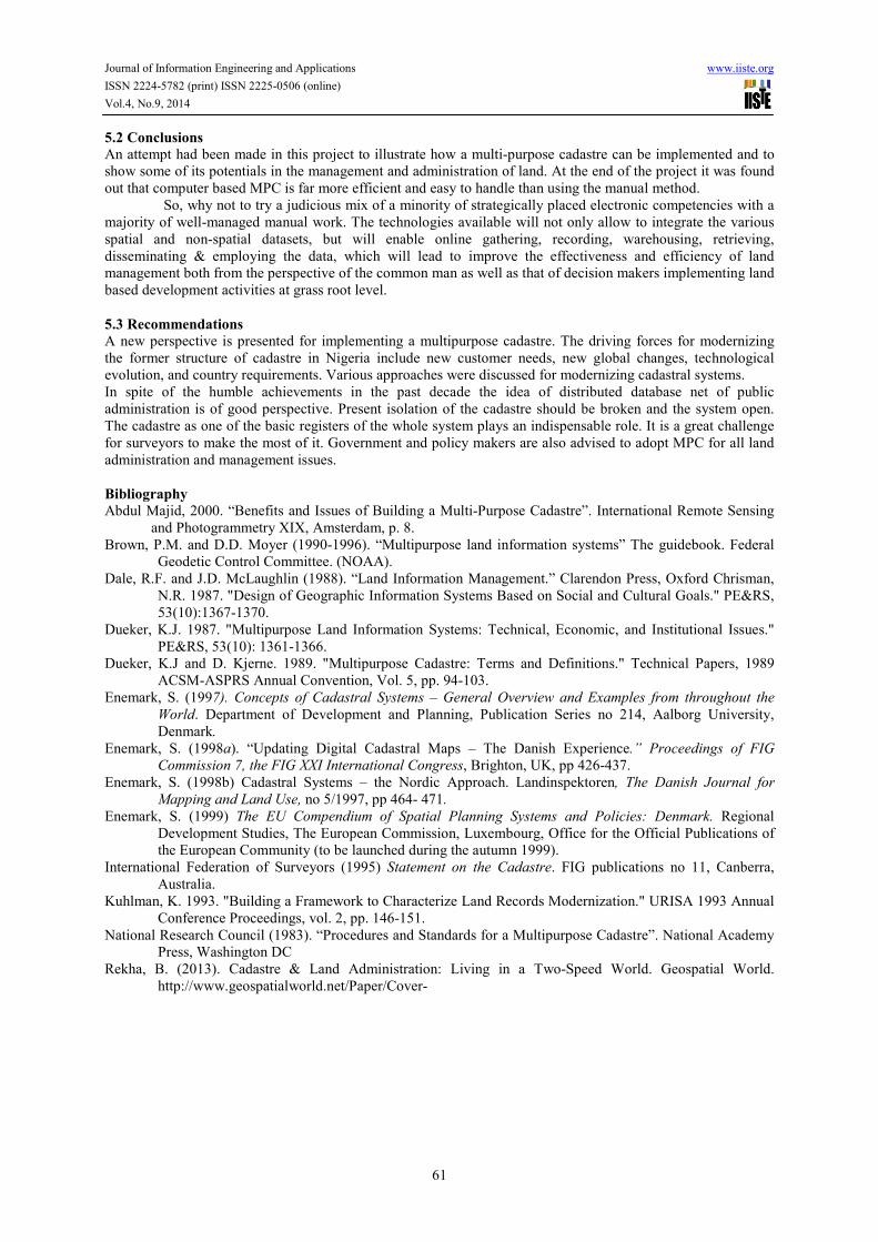
• Which properties have an area that is greater than 557.479 sq. meters? Fig5.
• Which properties have not paid their annual ground rent? Fig.6
• Which properties are used for commercial purposes? Fig.7
• Which properties have not been sold?
• Which properties have a market value that is less than N5, 500,000.00? Fig.9
• Instrument hyperlinked to a parcel. Fig.8
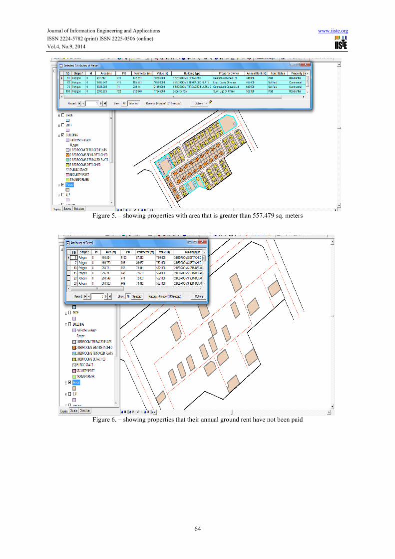
A query was performed on the database to find the parcels with building type of 3 Bedroom detached bungalow.
The result of the query shows that 52 buildings are 3 Bedroom Detached bungalows. Only the parcels with the
building type of 3 Bedroom detached bungalow are displayed.
The result of the query to determine the parcels with area greater than 557.479 sq. meters are shown
above. The parcels with area greater than 557.479 sq. meters are highlighted on the attribute table and on the
map respectively.
The field (Rent Status) and the value (not paid) are used to construct a definition query using the query
builder.
From the result the parcels that their annual ground rent have not been paid are displayed above
including their attributes. (See Fig.6)
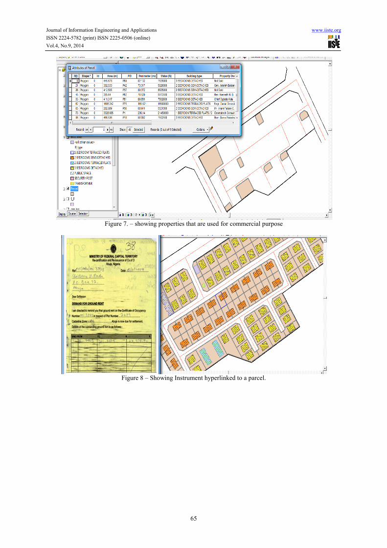
From the query performed in the database, the parcels that are used for commercial purposes are
displayed above with their attributes. The layer used was parcel, the field used was property type and the value
used was commercial. (See Fig.7)
The instruments that are associated with the individual parcel are hyperlinked to them. This helps to
locate and manage the documents for each parcel. The instrument that is associated with plot 45 is displayed
above.
The result of the analysis shows that seven parcels was valued less than N5,500,000.00 and they
include : plot 8, 9, 38, 46, 54, 59 and plot 89 (Fig. 9).
5.0 Summary, Conclusions and Recommendations
5.1 Summary
The importance of GIS application in the development of multi-purpose cadastre cannot be over emphasized in
the management and administration of land. This is due to the fact that efficient management of land cannot be
achieved using the manual or analogue method. Cadastral systems are necessary for sustainable social and
economic development. Cadastre started simply as a public register of boundaries and later went on to include
the various other interests in land which lead to the development of the concept of multipurpose cadastre. This is
a system designed to record, store and retrieve not only land-tenure data and land valuation information but also
a wide variety of information that can be functionally related to and referenced by property parcels. The
objective of the development of multi-purpose cadastre is to be able to take property inventories, as well as help
in utility management, school management, population estimates, disaster management, computerization of land
records, property tax generation and monitoring. This project shows a prototype of how MPC can be
implemented using Bethel Estate as case study. The major software used for the project is ArcGIS which enables
for data capture, integration, storage, retrieval and analysis. The themes created are: road, building, parcel, pillar
number and block themes. Attributes of the features were created and queries were performed on the database
and results were analyzed and reported. The result of the queries and analysis showed that: 52 properties houses
a 3 Bedroom Detached Bungalow, 4 properties has an area that is greater than 557.479 meters, the annual ground
rent of 18 properties has not been paid, 9 properties are used for commercial purpose, 25 properties have not
been sold and 7 properties are valued less than N5, 500,000.
Journal of Information Engineering and Applications www.iiste.org
ISSN 2224-5782 (print) ISSN 2225-0506 (online)
Vol.4, No.9, 2014
61
5.2 Conclusions
An attempt had been made in this project to illustrate how a multi-purpose cadastre can be implemented and to
show some of its potentials in the management and administration of land. At the end of the project it was found
out that computer based MPC is far more efficient and easy to handle than using the manual method.
So, why not to try a judicious mix of a minority of strategically placed electronic competencies with a
majority of well-managed manual work. The technologies available will not only allow to integrate the various
spatial and non-spatial datasets, but will enable online gathering, recording, warehousing, retrieving,
disseminating & employing the data, which will lead to improve the effectiveness and efficiency of land
management both from the perspective of the common man as well as that of decision makers implementing land
based development activities at grass root level.
5.3 Recommendations
A new perspective is presented for implementing a multipurpose cadastre. The driving forces for modernizing
the former structure of cadastre in Nigeria include new customer needs, new global changes, technological
evolution, and country requirements. Various approaches were discussed for modernizing cadastral systems.
In spite of the humble achievements in the past decade the idea of distributed database net of public
administration is of good perspective. Present isolation of the cadastre should be broken and the system open.
The cadastre as one of the basic registers of the whole system plays an indispensable role. It is a great challenge
for surveyors to make the most of it. Government and policy makers are also advised to adopt MPC for all land
administration and management issues.
Bibliography
Abdul Majid, 2000. “Benefits and Issues of Building a Multi-Purpose Cadastre”. International Remote Sensing
and Photogrammetry XIX, Amsterdam, p. 8.
Brown, P.M. and D.D. Moyer (1990-1996). “Multipurpose land information systems” The guidebook. Federal
Geodetic Control Committee. (NOAA).
Dale, R.F. and J.D. McLaughlin (1988). “Land Information Management.” Clarendon Press, Oxford Chrisman,
N.R. 1987. "Design of Geographic Information Systems Based on Social and Cultural Goals." PE&RS,
53(10):1367-1370.
Dueker, K.J. 1987. "Multipurpose Land Information Systems: Technical, Economic, and Institutional Issues."
PE&RS, 53(10): 1361-1366.
Dueker, K.J and D. Kjerne. 1989. "Multipurpose Cadastre: Terms and Definitions." Technical Papers, 1989
ACSM-ASPRS Annual Convention, Vol. 5, pp. 94-103.
Enemark, S. (1997). Concepts of Cadastral Systems – General Overview and Examples from throughout the
World. Department of Development and Planning, Publication Series no 214, Aalborg University,
Denmark.
Enemark, S. (1998a). “Updating Digital Cadastral Maps – The Danish Experience.” Proceedings of FIG
Commission 7, the FIG XXI International Congress, Brighton, UK, pp 426-437.
Enemark, S. (1998b) Cadastral Systems – the Nordic Approach. Landinspektoren, The Danish Journal for
Mapping and Land Use, no 5/1997, pp 464- 471.
Enemark, S. (1999) The EU Compendium of Spatial Planning Systems and Policies: Denmark. Regional
Development Studies, The European Commission, Luxembourg, Office for the Official Publications of
the European Community (to be launched during the autumn 1999).
International Federation of Surveyors (1995) Statement on the Cadastre. FIG publications no 11, Canberra,
Australia.
Kuhlman, K. 1993. "Building a Framework to Characterize Land Records Modernization." URISA 1993 Annual
Conference Proceedings, vol. 2, pp. 146-151.
National Research Council (1983). “Procedures and Standards for a Multipurpose Cadastre”. National Academy
Press, Washington DC
Rekha, B. (2013). Cadastre & Land Administration: Living in a Two-Speed World. Geospatial World.
http://www.geospatialworld.net/Paper/Cover-

Journal of Information Engineering and Applications www.iiste.org
ISSN 2224-5782 (print) ISSN 2225-0506 (online)
Vol.4, No.9, 2014
62
Figure 1. – Flowchart of procedures
Figure 2. – showing digitized features
Data Collection
Scanning of Analogue
Site Plans
Geo-referencing
Map Digitization
Building Attribute /
Database Creation
Data Analysis
Spatial / Attribute
Queries

Journal of Information Engineering and Applications www.iiste.org
ISSN 2224-5782 (print) ISSN 2225-0506 (online)
Vol.4, No.9, 2014
63
Figure 3 – showing how to build attribute of feature
Figure 4. – showing properties with building type of “3 Bedrooms Detached Bungalow
Journal of Information Engineering and Applications www.iiste.org
ISSN 2224-5782 (print) ISSN 2225-0506 (online)
Vol.4, No.9, 2014
64
Figure 5. – showing properties with area that is greater than 557.479 sq. meters
Figure 6. – showing properties that their annual ground rent have not been paid
Journal of Information Engineering and Applications www.iiste.org
ISSN 2224-5782 (print) ISSN 2225-0506 (online)
Vol.4, No.9, 2014
65
Figure 7. – showing properties that are used for commercial purpose
Figure 8 – Showing Instrument hyperlinked to a parcel.

Journal of Information Engineering and Applications www.iiste.org
ISSN 2224-5782 (print) ISSN 2225-0506 (online)
Vol.4, No.9, 2014
66
Figure 9–Showing properties with market value that is less than N5,500,000.00

The IISTE is a pioneer in the Open-Access hosting service and academic event
management. The aim of the firm is Accelerating Global Knowledge Sharing.
More information about the firm can be found on the homepage:
http://www.iiste.org
CALL FOR JOURNAL PAPERS
There are more than 30 peer-reviewed academic journals hosted under the hosting
platform.
Prospective authors of journals can find the submission instruction on the
following page: http://www.iiste.org/journals/ All the journals articles are available
online to the readers all over the world without financial, legal, or technical barriers
other than those inseparable from gaining access to the internet itself. Paper version
of the journals is also available upon request of readers and authors.
MORE RESOURCES
Book publication information: http://www.iiste.org/book/
IISTE Knowledge Sharing Partners
EBSCO, Index Copernicus, Ulrich's Periodicals Directory, JournalTOCS, PKP Open
Archives Harvester, Bielefeld Academic Search Engine, Elektronische
Zeitschriftenbibliothek EZB, Open J-Gate, OCLC WorldCat, Universe Digtial
Library , NewJour, Google Scholar