lake ranch reservoir outlet works improvements study/ mitigated negative declaration _____ lake...
TRANSCRIPT

Initial Study/
Mitigated Negative Declaration _______________
Lake Ranch Reservoir Outlet Works Improvements
Prepared for
1221A S. Bascom Avenue
San Jose, CA 95128
CEQA Lead Agency
Santa Clara County Parks
298 Garden Hill Drive Los Gatos, CA 95032
Prepared by
Denise Duffy & Associates, Inc.
947 Cass Street, Suite 5 Monterey, CA 93940
January 2016


Lake Ranch Reservoir Outlet Improvements i Initial Study Table of Contents
Table of Contents Chapter 1. Project Information...................................................................................................................... 1 Chapter 2. Project Description ...................................................................................................................... 3 Chapter 3. Environmental Evaluation ......................................................................................................... 17
A. Aesthetics.................................................................................................................................... 19 B. Agricultural and Forest Resources .............................................................................................. 20 C. Air Quality .................................................................................................................................. 21 D. Biological Resources .................................................................................................................. 24 E. Cultural Resources ...................................................................................................................... 45 F. Geology and Soils ....................................................................................................................... 46 G. Greenhouse Gas Emissions......................................................................................................... 53 H. Hazards and Hazardous Materials .............................................................................................. 53 I. Hydrology and Water Quality .................................................................................................... 55 J. Land Use ..................................................................................................................................... 58 K. Mineral Resources ...................................................................................................................... 59 L. Noise ........................................................................................................................................... 60 M. Population and Housing .............................................................................................................. 61 N. Public Services ........................................................................................................................... 62 O. Recreation ................................................................................................................................... 62 P. Transportation ............................................................................................................................. 63 Q. Utilities & Service Systems ........................................................................................................ 65 R. Mandatory Findings of Significance .......................................................................................... 66
Chapter 4. References ................................................................................................................................. 68 List of Figures Figure 1. Project Location Map ................................................................................................................... 6 Figure 2. Aerial Map .................................................................................................................................... 7 Figure 3. Site Plan – Saratoga Dam ............................................................................................................. 9 Figure 4. Site Plan – Beardsley Dam ......................................................................................................... 10 Figure 5. Demolition Plan – Saratoga Dam ............................................................................................... 11 Figure 6. Demolition Plan – Beardsley Dam ............................................................................................. 12 Figure 7. Staging Areas .............................................................................................................................. 13 Figure 8A. Site Photos ............................................................................................................................... 14 Figure 8B. Site Photos ............................................................................................................................... 15 Figure 9. Saratoga Dam Habitat Map ........................................................................................................ 30 Figure 10. Beardsley Dam Habitat Map .................................................................................................... 31 Figure 11. Saratoga Dam Wetland Delineation Map ................................................................................. 37 Figure 12. Beardsley Dam Wetland Delineation Map ............................................................................... 38 Figure 13. Saratoga Dam Geologic Map ................................................................................................... 49 Figure 14. Beardsley Dam Geologic Map ................................................................................................. 50 Appendices A. Biological Resources Report B. Wetland Delineation C. Arborist Report D. Geologic/Geotechnical Study
Lake Ranch Reservoir Outlet Improvements ii Initial Study Table of Contents
List of Acronyms acre Bay Area Air Quality Management District
ac BAAQMD
California Department of Fish and Wildlife CDFW California Endangered Species Act CESA California Environmental Quality Act CEQA California Native Plant Protection Act CNPPA California Native Plant Society CNPS California Natural Diversity Database CNDDB California Red-Legged Frog CRLF Clean Water Act CWA Denise Duffy & Associates, Inc. DD&A Environmentally Sensitive Habitat ESHA feet ft Federal Endangered Species Act FESA Foothill Yellow-Legged Frog Greenhouse Gas
FYLG GHG
Geographic Information System GIS Global Positioning System GPS Habitat Conservation Plan HCP hectare Ha high-density polyethylene HDPE Individual Permit Initial Study
IP IS
kilometer km meter m Migratory Bird Treaty Act Million Gallons
MBTA MG
mile Mitigated Negative Declaration
mi MND
National Pollution Discharge Elimination System NPDES Nationwide Permit NWP Regional Water Quality Control Board RWQCB Santa Clara Valley Water District SCVWD San Jose Water Company SJWC Streambed Alteration Agreement SAA United States Army Corps of Engineers USACE United States Fish and Wildlife Service USFWS United States Geological Survey USGS Western Pond Turtle WPT

Lake Ranch Reservoir Outlet Improvements 1 Chapter 1 Initial Study Project Information
Chapter 1. Project Information 1. Project Title: Lake Ranch Reservoir Outlet Works Improvements
2. Lead Agency Name and Address: Santa Clara County Parks, 298 Garden Hill Drive, Los Gatos,
CA 95032 Contact: Kimberly Brosseau 408-355-2230 3. Project Proponent: San Jose Water Company, 1221A S. Bascom Avenue, San Jose, CA 95128
Contact: Bill Tuttle, Director of Engineering, Water Services and Planning 408-279-7861
4. Project Location: The project site is located within Sanborn County Park, about two miles south of the City of Saratoga, in Santa Clara County, California.
5. Project Description Summary: San Jose Water Company proposes to rehabilitate the Lake
Ranch Reservoir in accordance with the requirements of the California Division of Safety of Dams. The project is the construction of siphons for both the north and south dams and grouting of the existing outlet pipes.
6. Santa Clara County General Plan Designation: Regional Parks, Existing
7. Santa Clara County Zoning Designation: HS (Hillside)

Lake Ranch Reservoir Outlet Improvements 2 Chapter 1 Initial Study Project Information
This page left intentionally blank.

Lake Ranch Reservoir Outlet Improvements Chapter 2 Initial Study Project Description
3
Chapter 2. Project Description 2.1 INTRODUCTION This Initial Study/Mitigated Negative Declaration (IS/MND) has been prepared by Denise Duffy & Associates on behalf of the applicant, San Jose Water Company (SJWC), in conjunction with the lead agency, Santa Clara County Parks. This document has been completed in accordance with the California Environmental Quality Act (CEQA), Public Resource Code §21000 et seq. 2.2 SAN JOSE WATER COMPANY OVERVIEW SJWC is an investor owned public utility that serves approximately one million people in the greater San Jose metropolitan area. SJWC supplies water to the cities of San Jose, Cupertino, Campbell, Monte Sereno, Saratoga, Los Gatos, and unincorporated portions of Santa Clara County. SJWC also provides services to other utilities including operations and maintenance, billing, and backflow testing. Approximately 90 percent of the water SJWC distributes to customers is provided by the Santa Clara Valley Water District and the remaining 10 percent is produced by the SJWC-owned Montevina and Saratoga water treatment plants. SJWC serves water to a combined number of 215,115 service connections with a combined population of approximately one million. 2.3 PROJECT LOCATION The project is located within Sanborn County Park in the Santa Cruz Mountains; about two miles south of the City of Saratoga in Santa Clara County (see Figure 1). SJWC service roads provide access to Lake Ranch Reservoir from the north via Sanborn Road and from the south via Black Road. Public access to Lake Ranch Reservoir is provided only by trails within Sanborn Park. A portion of the John Nicholas Trail extends along the access road along the reservoir’s east boundary. An aerial showing the reservoir and project area is provided in Figure 2.
2.4 PROJECT DESCRIPTION SJWC is proposing rehabilitation of the Lake Ranch Reservoir in accordance with the requirements of the California Division of Safety of Dams (DSOD). Lake Ranch Reservoir is a small, approximately 70 million gallon (MG) reservoir constructed between 1874 and 1876.
The reservoir occupies a linear, topographic saddle within the San Andreas Fault zone and has two relatively small earth dams at either end. The reservoir receives water from runoff and tributary drainages that flow from slopes to the west. Based on available information, the north dam (Saratoga dam) is about 20 to 25 feet high and about 685 feet long, with a crest width of about 30 to 50 feet. The outlet pipe beneath Saratoga dam is about 200 feet long and eight inches in diameter. This outlet provides stream releases to Saratoga Creek via Sanborn Creek. The south dam (Beardsley dam) is about 25 to 30 feet high and about 150 feet long, with a crest width of about 27 to 40 feet. The outlet pipe at Beardsley dam is about 190 feet long and 12 inches in diameter. This outlet drains into Lyndon Canyon Creek, feeding SJWC’s Beardsley intake and ultimately Montevina Water Treatment Plant. Both outlet pipes are buried beneath their respective embankments and recent surveys indicate the pipes are in various states of disrepair.
A gravel access road generally extends along the east boundary of the reservoir, connecting to existing SJWC service roads to the north and south.

Lake Ranch Reservoir Outlet Improvements Chapter 2 Initial Study Project Description
4
Due to the age of the embankments and lack of details regarding their original construction, SJWC proposes to construct siphons over both dams and grout the existing outlet pipes, rather than replace them. Based on the DSOD’s drawdown requirements, the siphon at Saratoga dam will consist of a 12-inch diameter pipe, as shown in the site plan in Figure 3. At Beardsley dam, the siphon will consist of a 4-inch-diameter pipe with 16-inch emergency pipe, as indicated in Figure 4. The siphons will be constructed using high-density polyethylene (HDPE) piping. The pipes will be buried and concrete-encased where they cross over the dam abutments, and will be mounted on the lake bottom with floating intakes within the reservoir.
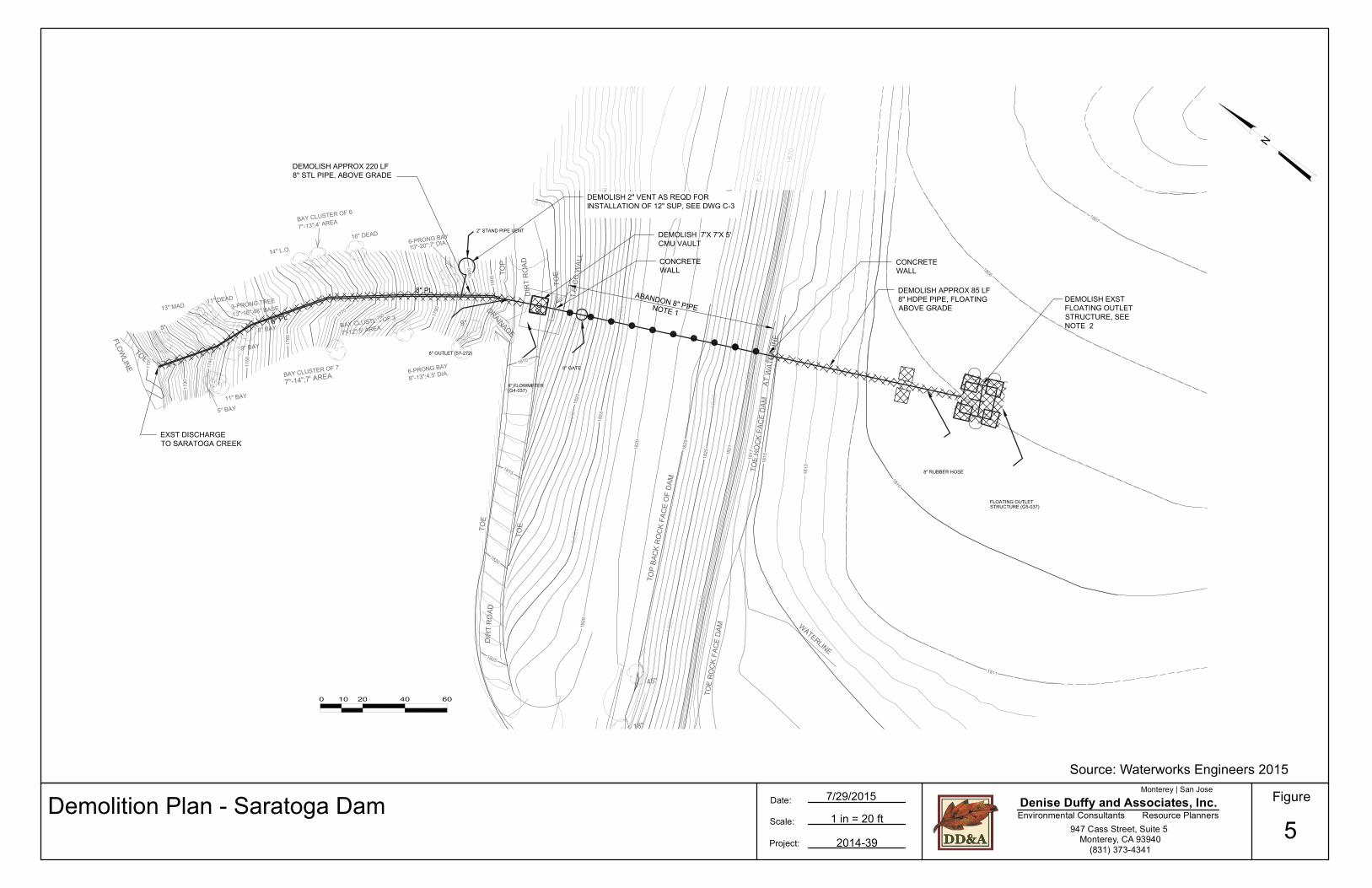
Demolition plans for the project are presented in Figures 5 and 6. For the Saratoga dam, the project proposes to demolish and remove the following structures: floating wood and aluminum outlet structure, 8-inch floating HDPE pipe, concrete vault, and 8-inch above grade steel pipeline. However, the existing mooring piles for the floating outlet structure will be protected and reused as part of the new improvements. In addition, the buried 8-inch pipe will be abandoned by pressure grouting pipe.
For the Beardsley dam, the project includes demolition/removal of the steel and concrete outlet structure, valve, extension stem, metal supports and handwheel (concrete supports to remain for reuse), 6-inch steel pipeline above grade, 10-inch ductile iron pipeline above grade, and wood discharge structure to Lyndon Canyon (or Beardsley) Creek. In addition, the buried 10-inch pipe and buried 6-inch steel pipe will be abandoned by pressure grouting pipe. A temporary cofferdam will be installed to create a dry work environment for construction work at the Beardsley dam.
The proposed reservoir outlet improvements will require the removal of three trees. Tree protection measures will be implemented in areas where construction activities may affect existing trees in accordance with an arborist report prepared for the project (Monarch Consulting Arborists, March 2015).
The project proposes to implement the following best management practices, at a minimum, in order to avoid or minimize environmental impacts: • Staging will occur on access roads or other disturbed areas that are already compacted and support
only ruderal vegetation. Similarly, all maintenance equipment and materials will be contained within the existing access roads or other pre-determined staging areas. The staging areas are shown in Figure 7.
• Building materials, including chemicals and sediment, will not be stockpiled or stored where they could spill into the reservoir or drainages.
• No runoff from staging areas will be allowed to enter the reservoir or other drainages without being
subjected to adequate filtration (e.g., vegetated buffer, hay bales, silt screens).
• During the dry season, no stockpiled soils will remain exposed for more than seven days. During the wet season, no stockpiled soils will remain exposed unless surrounded by properly installed and maintained silt fencing or other means of erosion control.
• Equipment and materials for cleanup of spills will be available on the project site at all times and
spills and leaks will be cleaned up immediately and disposed of in accordance with all regulatory requirements.

Lake Ranch Reservoir Outlet Improvements Chapter 2 Initial Study Project Description
5
2.5 PROJECT OBJECTIVES The purpose of the project is to rehabilitate the Lake Ranch Reservoir outlet structures in accordance with the requirements of the California Division of Safety of Dams. 2.6 PROJECT SCHEDULE Construction of the reservoir outlet improvements is planned to begin in April 2016 and be completed in October 2016. 2.7 PROJECT APPROVALS The project will require the following approvals:
• U.S. Army Corps of Engineers – Clean Water Act Section 404 Permit • California Department of Fish and Wildlife – Streambed Alteration Agreement • County of Santa Clara – Grading, Building • San Francisco Bay Regional Water Quality Control Board – Section 401 Water Quality
Certification Permit, Stormwater Pollution Prevention Plan

^
U
0 21 mi
0 21 km
Scale:
Project:
Date:1 inch = 1 miles
2014-39
Figure
1Denise Duffy and Associates, Inc.
Monterey | San Jose
Environmental Consultants Resource Planners947 Cass Street, Suite 5
Monterey, CA 93940(831) 373-4341C:\GIS\GIS_Projects\2014-39 Lake Ranch\Map Products\ADIS\Figure 1 Project Location.mxd
Service Layer Credits: Sources: Esri, HERE, DeLorme, USGS, Intermap, increment P Corp.,NRCAN, Esri Japan, METI, Esri China (Hong Kong), Esri (Thailand), TomTom, MapmyIndia, ©
Project Location Map 7/31/2015
Project Location

LakeRanch
Reservoir
Saratoga Dam
BeardsleyDam
¯
0 500250 Feet
0 10050 Meters
Scale:
Project:
Date:1 inch = 240 feet
2014-39
Figure
2Denise Duffy and Associates, Inc.
Monterey | San Jose
Environmental Consultants Resource Planners947 Cass Street, Suite 5
Monterey, CA 93940(831) 373-4341
Aerial Map
Service Layer Credits: Source: Esri,DigitalGlobe, GeoEye, i-cubed,USDA, USGS, AEX, Getmapping,
7/31/2015
C:\GIS\GIS_Projects\2014-39 Lake Ranch\Map Products\ADIS\Figure 2 Aerial Map.mxd
J o h nN i c h o l a s
T r a i l

Lake Ranch Reservoir Outlet Improvements Chapter 2 Initial Study Project Description
8
This page left intentionally blank

Denise Duffy and Associates, Inc.Monterey | San Jose
Environmental Consultants Resource Planners947 Cass Street, Suite 5
Monterey, CA 93940(831) 373-4341
Scale:
Project:
Date: Figure
Source: Waterworks Engineers 2015
Site Plan - Saratoga Dam3
2014-39
1 in = 30 ft
7/29/2015
1.6'
CC
WAL
L
DIR
T R
OAD
TOE
TOE
GC
18+25
10+00
11+00
12+0
0
13+0
0
14+00
15+00
16+00
17+00
18+00
SCALE: 1" = 20'
SEE DWG SM-11
GROUTED RIP RAP
ACCESS TRAIL,SEE NOTE 1
12" SUP, NORTH DAMALIGNMENT, SEE SHEET C-3TO C-5 FOR PLAN & PROFILE
12" SUP FLOW METERVAULT, SEE DWG SM-3
12" SUP, NORTH DAMALIGNMENT, SHEET C-3 TOC-4 FOR PLAN & PROFILE
12" FLOATING SIPHONINLET - SARATOGASEE DWG SM-5
C-3
DRAWINGSHEET NO., TYP
C-4
C-5
12" SIPHON PRIMING /AIR REMOVALSTATION SEE DWG SM-1
MATCHLINE - 13+00
MATCHLINE - 16+00
12" SUP ARTICULATING PIPEJOINT, SEE DWG SM-13
VACUUM PRIMINGMECHANICAL BUILDING
SOLAR ARRAY

Denise Duffy and Associates, Inc.Monterey | San Jose
Environmental Consultants Resource Planners947 Cass Street, Suite 5
Monterey, CA 93940(831) 373-4341
Scale:
Project:
Date: Figure
Source: Waterworks Engineers 2015
Site Plan - Beardsley Dam4
2014-39
1 in = 10 ft
7/29/2015
10+0
0
11+0
0
12+00
13+00
13+8
7
SCALE: 1" = 10'
4" SUP / 16" EMR FLOW METERVAULT, SEE DWG SM-4
ACCESS TRAIL,SEE NOTE 2
EXST OVERFLOW STRUCTURE DEBRIS GUARDPOSTS, 2' DIAM VERTICAL GALVANIZED STEELPIPE, @ APPROX 2' SPACING
SEE NOTE 4
STA 10+65, 4" SUP AND16" EMR ARTICULATINGPIPE JOINT SEE DWGSM-13
4" SUP / 16" EMRFLOW METER VAULT,SEE DWG SM-4
NOTES:1. CONTRACTOR TO PROTECT LARGE OAK TREES.2. ACCESS TRAIL SHALL CONSIST OF RAILROAD TIE STEPS SPACED WITH AGGREGATE BASE
FOOT PATH BETWEEN STEPS.3. CONTRACTOR SHALL PROVIDE 20'L X 8'W X 3' MIN DEPTH GROUTED RIP RAP.
CONTRACTOR TO COORDINATE EXTENTS OF RIP RAP WITH ENGINEER PRIOR TOPLACEMENT.
4. CONTRACTOR TO COORDINATE EXACT ALIGNMENT OF PIPLINES TO CLEAR EXISTINGOVERFLOW STRUCTURE DEBRIS GUARD POSTS.
SOUTH DAM DISCHARGE,TO NORTH FORKBEARDSLEY CR +/- 1790'SEE DWG SM-12
GROUTED RIP RAP,NOTE 3
SEE NOTE 1
16" EMR, SOUTH DAMALIGNMENT, SEE DWG C-7FOR PROFILE
4" SUP, CL OFFSET 2.5'FROM CL OF 16" EMRSEE DWG C-7 FOR PROFILE
NOTE 1
4" FLOATING SIPHON INLETAND 16" EMR SIPHON INLET,SEE DWG SM-7
Denise Duffy and Associates, Inc.Monterey | San Jose
Environmental Consultants Resource Planners947 Cass Street, Suite 5
Monterey, CA 93940(831) 373-4341
Scale:
Project:
Date: Figure
Source: Waterworks Engineers 2015
Demolition Plan - Saratoga Dam5
2014-39
1 in = 20 ft
7/29/2015
1.6'
CC
WAL
L
DIR
T R
OAD
TOE
TOE
6" PL
8" OUTLET (57-272)
8" GATE
8" RUBBER HOSE
2" STAND PIPE VENT
FLOATING OUTLETSTRUCTURE (G5-037)
8" FLOWMETER(G4-037)

Denise Duffy and Associates, Inc.Monterey | San Jose
Environmental Consultants Resource Planners947 Cass Street, Suite 5
Monterey, CA 93940(831) 373-4341
Scale:
Project:
Date: Figure
Source: Waterworks Engineers 2015
Demolition Plan - Beardsley Dam6
2014-39
1 in = 10 ft
7/29/2015
10" PL
ROCK
WALL
ROCK PILE
DIRT ROAD
19" CMP
F/L ELEV.=1824.73
TOP ELEV.=1826.31
CC WALL
ROCK PILE
48" RCP
CNOC '_X '6 X'6 HSILOMED,ERUTCURTS TELTUO LEETS DNA
5971 -/+ LE VNI
FO POTMAD HTUOS
WOLFREVO TSXEEES ,ERUTCURTS
1 ETON
FL 03 HSILOMEDEDARG EVOBA ,EPIP ID "01
EGRAHCSID TSXEKROF HTRON OT
KEERC YELSDRAEB
"6-'3 X '7 X '5 HSILOMEDEGRAHCSID DOOW
ERUTCURTS
K
FL 02 HSILOMEDEVOBA ,EPIP LTS "6
EDARG
,METS NOISNETXE ,EVLAV HSILOMED.LEEHWDNAH DNA ,STROPPUS LATEM
NIAMER OT STROPPUS CNOC
TSXE EVOMERSEERT
FL 59 HSILOMED,EPIP LTS "6
EDARG EVOBA
ABANDON 10" PIPE, NOTE 2
NOTES:
1. CONTRACTOR TO SAWCUT CONC OVERFLOW WINDOW INVERT FROM1819.2 TO 1818.78 TO PROVIDE A DISTANCE OF 11.1-FT FROM THE INVOF THE WINDOW TO THE MIN TOP OF DAM ELEV OF 1829.88.
2. CONTRACTOR TO ABANDON 8-INCH PIPE BY PRESSURE GROUTING PIPETO EXTENTS SHOWN. SEE SPEC SECTION 02220.
3.
EXST OVERFLOW STRUCTURE,DEBRIS GURAD POSTS, 2" DIAMVERTICAL GALVANIZED STL PIPE,APPROX 60 @ 2' SPACING

¯
0 525262.5 Feet
0 10050 Meters
Scale:
Project:
Date:1 inch = 250 feet
2014-39
Figure
7Denise Duffy and Associates, Inc.
Monterey | San Jose
Environmental Consultants Resource Planners947 Cass Street, Suite 5
Monterey, CA 93940(831) 373-4341
Approximate Staging Locations
Service Layer Credits: Source: Esri,DigitalGlobe, GeoEye, i-cubed, USDA,USGS, AEX, Getmapping, Aerogrid, IGN,
8/12/2015
C:\GIS\GIS_Projects\2014-39 Lake Ranch\Map Products\ADIS\Figure 7 Staging.mxd
Staging Locations
LakeRanch
Reservoir
Saratoga Dam
BeardsleyDam
J o h nN i c h o l a s
T r a i l

Figure
8ADenise Duffy and Associates, Inc.
Monterey | San Jose
Environmental Consultants Resource Planners947 Cass Street, Suite 5
Monterey, CA 93940(831) 373-4341
Site Photos
Photo 1. Lake Ranch Reservoir from Beardsley Dam facing northwest.
Photo 2. Lake Ranch Reservoir from Saratoga Dam facing southeast.
Figure
8BDenise Duffy and Associates, Inc.
Monterey | San Jose
Environmental Consultants Resource Planners947 Cass Street, Suite 5
Monterey, CA 93940(831) 373-4341
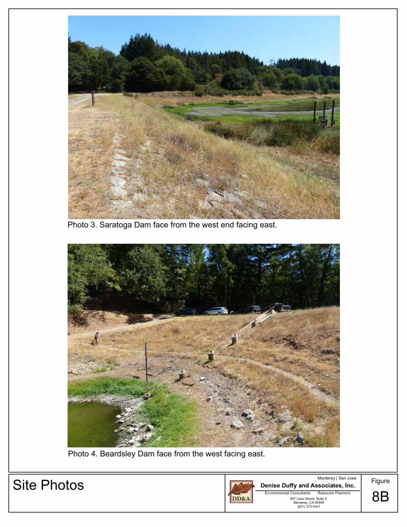
Site Photos
Photo 3. Saratoga Dam face from the west end facing east.
Photo 4. Beardsley Dam face from the west facing east.

Lake Ranch Reservoir Outlet Improvements Chapter 3 Initial Study Environmental Evaluation
16
This page left intentionally blank .

Lake Ranch Reservoir Outlet Improvements Chapter 3 Initial Study Environmental Evaluation
18
EVALUATION OF ENVIRONMENTAL IMPACTS 1. A brief explanation is required for all answers except “No Impact” answers that are adequately supported by the information sources a lead agency cites in the parentheses following each question. A “No Impact” answer is adequately supported if the referenced information sources show that the impact simply does not apply to projects like the one involved (e.g., the project falls outside a fault rupture zone). A “No Impact” answer should be explained where it is based on project-specific factors as well as general standards (e.g., the project will not expose sensitive receptors to pollutants, based on project-specific screening analysis). 2. All answers must take into account the whole action involved, including offsite as well as onsite, cumulative as well as project-level, indirect as well as direct, and construction as well as operational impacts. 3. Once the lead agency has determined that a particular physical impact may occur, then the checklist answers must indicate whether the impact is potentially significant, less than significant with mitigation, or less than significant. "Potentially Significant Impact" is appropriate if there is substantial evidence that an effect may be significant. If there are one or more "Potentially Significant Impact" entries when the determination is made, an EIR is required. 4. “Negative Declaration: Less Than Significant With Mitigation Incorporated” applies where the incorporation of mitigation measures has reduced an effect from “Potentially Significant Impact” to a “Less Than Significant Impact.” The lead agency must describe the mitigation measures, and briefly explain how they reduce the effect to a less than significant level mitigation measures from Section XVII, “Earlier Analyses,” may be cross-referenced). 5. Earlier analyses may be used where, pursuant to the tiering, program EIR, or other CEQA process, an effect has been adequately analyzed in an earlier EIR or negative declaration. Section 15063(c)(3)(D). In this case, a brief discussion should identify the following: a) Earlier Analysis Used. Identify and state where they are available for review. b) Impacts Adequately Addressed. Identify which effects from the above checklist were within the scope of and adequately analyzed in an earlier document pursuant to applicable legal standards, and state whether such effects were addressed by mitigation measures based on the earlier analysis. c) Mitigation Measures. For effects that are “Less than Significant with Mitigation Measures Incorporated,” describe the mitigation measures, which were incorporated or refined from the earlier document and the extent to which they address site-specific conditions for the project. 6. Lead agencies are encouraged to incorporate into the checklist references to information sources for potential impacts (e.g., general plans, zoning ordinances). Reference to a previously prepared or outside document should, where appropriate, include a reference to the page or pages where the statement is substantiated. 7. Supporting Information Sources: A source list should be attached, and other sources used or individuals contacted should be cited in the discussion. 8. This is only a suggested form, and lead agencies are free to use different formats; however, lead agencies should normally address the questions from this checklist that are relevant to a project’s environmental effects in whatever format is selected. 9. The explanation of each issue should identify: a) The significance criteria or threshold, if any, used to evaluate each question; and b) The mitigation measure identified, if any, to reduce the impact to less than significance.

Lake Ranch Reservoir Outlet Improvements Chapter 3 Initial Study Environmental Evaluation
19
ENVIRONMENTAL SETTING AND IMPACTS This Initial Study is based on the most current CEQA Environmental Checklist Form (Appendix G of the CEQA Guidelines, 2015). The checklist is followed by explanatory comments corresponding to each checklist item. The sources of information are cited in Chapter 4 References. A. AESTHETICS Setting The Lake Ranch Reservoir is located in a relatively remote location within Sanborn County Park, in the Santa Cruz Mountains above Saratoga and Los Gatos. Photos of the project site are presented in Figure 8. The visual/aesthetic character of the property is that of a small reservoir surrounded by hillsides and thickly wooded forest. A portion of the John Nicholas Trail extends along the access road along the reservoir’s east boundary. Impacts and Mitigation Thresholds per CEQA Checklist
ENVIRONMENTAL IMPACTS
Potentially Significant
Issues
Potentially Significant
Unless Mitigation
Incorporated
Less Than Significant
Impact
No Impact
ChecklistSource(s)
1. AESTHETICS. Would the project:
a) Have a substantial adverse effect on a scenic vista? X 1, 2
b) Substantially damage scenic resources, including but not limited to trees, rock outcroppings, and historic buildings within a state scenic highway?
X 1, 2
c) Substantially degrade the existing visual character or quality of the site and its surroundings? X 1, 2
d) Create a new source of substantial light or glare, which would adversely affect day or nighttime views in the area? X 1, 2
Explanation a) No Impact. The reservoir is located in a relatively remote location within Sanborn Park, with no
residential development in the immediate project vicinity. The project would not have a substantial adverse effect on a scenic vista.
b) No Impact. The project is not located near, or visible from, any state scenic highways. c) Less Than Significant Impact. The visual/aesthetic character of the project site is that of a small
reservoir, gravel access road, and surrounding forest. There are no residential uses within the immediate vicinity of the project and the project site is not visible from any public streets. The project will replace existing reservoir outlet features and will not adversely affect the visual quality of the reservoir or project area upon completion of construction.

Lake Ranch Reservoir Outlet Improvements Chapter 3 Initial Study Environmental Evaluation
20
The project site is located within Sanborn Park and a portion of the John Nicholas Trail extends along the access road along the reservoir’s east boundary. The proposed reservoir outlet improvements would not noticeably alter the view of the site from this public trail upon completion of construction activities.
In conclusion, the project will not degrade the existing visual character or quality of the site and
its surroundings. d) No Impact. The project is improvement to the reservoir outlets and will not create any new
sources of light or glare. B. AGRICULTURAL AND FOREST RESOURCES Setting In the State of California, agricultural land is given consideration under CEQA. According to Public Resources Code §21060.1, “agricultural land” is identified as prime farmland, farmland of statewide importance, or unique farmland, as defined by the U.S. Department of Agriculture land inventory and monitoring criteria, as modified for California. CEQA also requires consideration of impacts on lands that are under Williamson Act contracts. The project area is identified as “other land” on the Santa Clara County Important Farmlands Map. Other land is described as “land not included in any other mapping category,” and can include low density rural developments, brush, timber, wetlands, and riparian areas not suitable for livestock grazing. CEQA requires the evaluation of forest and timber resources where they are present. The site does not contain any forest land as defined in Public Resources Code Section 12220(g)), timberland as defined by Public Resources Code Section 4526, or property zoned for Timberland Production as defined by Government Code Section 51104(g). Impacts and Mitigation Thresholds per CEQA Checklist
ENVIRONMENTAL IMPACTS
Potentially Significant
Issues
Potentially Significant
Unless Mitigation
Incorporated
Less Than Significant
Impact
No Impact
Source(s)
2. AGRICULTURAL AND FOREST RESOURCES. In determining whether impacts to agricultural resources are significant environmental effects, lead agencies may refer to the California Agricultural Land Evaluation and Site Assessment Model (1997) prepared by the California Department of Conservation as an optional model to use in assessing impacts on agriculture and farmland. In determining whether impacts to forest resources, including timberland, are significant environmental effects, lead agencies may refer to information compiled by the California Department of Forestry and Fire Protection regarding the state’s inventory of forest land, including the Forest and Range Assessment Project and the Forest Legacy Assessment project; and forest carbon measurement methodology provided in Forest Protocols adopted by the California Air Resources Board. Would the project:
a) Convert Prime Farmland, Unique Farmland, or Farmland of Statewide Importance (Farmland), as shown on the maps prepared pursuant to the Farmland Mapping and Monitoring Program of the California Resources Agency, to non-agricultural use?
X 1,2,5
b) Conflict with existing zoning for agricultural use, or a Williamson Act contract? X 1,2,5

Lake Ranch Reservoir Outlet Improvements Chapter 3 Initial Study Environmental Evaluation
21
ENVIRONMENTAL IMPACTS
Potentially Significant
Issues
Potentially Significant
Unless Mitigation
Incorporated
Less Than Significant
Impact
No Impact
Source(s)
c) Conflict with existing zoning for, or cause rezoning of, forest land (as defined in Public Resources Code section 12220(g)), timberland (as defined by Public Resources Code section 4526), or timberland zoned Timberland Production (as defined by Government Code section 51104(g))?
X 1,2
d) Result in the loss of forest land or conversion of forest land to non-forest uses? X 1,2
e) Involve other changes in the existing environment which, due to their location or nature, could result in conversion of Farmland to non-agricultural use or conversion of forest land to non-forest use?
X 1,2,5
Explanation a) No Impact. The project site is designated as “other land” on the Important Farmlands Map for
Santa Clara County and does not contain any prime farmland, unique farmland, or farmland of statewide importance. The proposed reservoir outlet improvements would not affect agricultural land.
b) No Impact. The project site is not zoned for agricultural use and does not contain lands under
Williamson Act contract; therefore, no conflicts with agricultural uses would occur. c) No Impact. No other changes to the environment would occur from construction of the proposed
improvements that would result in conversion of timberland to non-agricultural uses. d) No Impact. The project would not impact forest resources since the site does not contain any
forest land as defined in Public Resources Code Section 12220(g)), timberland as defined by Public Resources Code Section 4526, or property zoned for Timberland Production as defined by Government Code Section 51104(g).
e) No Impact. As per the discussion above, the project would not involve changes in the existing
environment which, due to their location or nature, could result in conversion of forest land or agricultural land.
C. AIR QUALITY Regulatory Background The project site is located within the San Francisco Bay Area Air Basin. The Bay Area Air Quality Management District (BAAQMD) is the local agency authorized to regulate stationary air quality sources in the Bay Area. The Federal Clean Air Act and the California Clean Air Act mandate the control and reduction of specific air pollutants. Under these Acts, the U.S. Environmental Protection Agency and the California Air Resources Board have established ambient air quality standards for specific "criteria" pollutants, designed to protect public health and welfare. Primary criteria pollutants include carbon monoxide (CO), reactive organic gases (ROG), nitrogen oxides (NOX), particulate matter (PM10), sulfur dioxide (SO2), and lead (Pb). Secondary criteria pollutants include ozone (O3), and fine particulate matter.

Lake Ranch Reservoir Outlet Improvements Chapter 3 Initial Study Environmental Evaluation
22
Setting Air quality in the region is controlled by the rate of pollutant emissions and meteorological conditions. Meteorological conditions such as wind speed, atmospheric stability, and mixing height may all affect the atmosphere’s ability to mix and disperse pollutants. Long-term variations in air quality typically result from changes in air pollutant emissions, while frequent, short-term variations result from changes in atmospheric conditions. The San Francisco Bay Area is considered to be one of the cleanest metropolitan areas in the country with respect to air quality. BAAQMD monitors air quality conditions at more than 30 locations throughout the Bay Area. Sensitive receptors consist of groups of people more affected by air pollution than others. The California Air Resources Board (CARB) has identified the following as the most likely to be affected by air pollution: children under 14, the elderly over 65, athletes, and people with cardiovascular and chronic respiratory diseases. Locations that may contain a high concentration of these sensitive population groups include residential areas, hospitals, daycare centers, elder care facilities, elementary schools, and parks. There are no sensitive receptors in the immediate project vicinity. Hikers may occasionally pass through the project area on the adjacent John Nicholson Trail (part of the trail network within Sanborn County Park). Impacts and Mitigation Thresholds per CEQA Checklist
ENVIRONMENTAL IMPACTS
Potentially Significant
Issues
Potentially Significant
Unless Mitigation
Incorporated
Less Than Significant
Impact
No Impact
ChecklistSource(s)
3. AIR QUALITY. Where available, the significance criteria established by the applicable air quality management or air pollution control district may be relied upon to make the following determinations. Would the project:
a) Conflict with or obstruct implementation of the applicable air quality plan? X 3
b) Violate any air quality standard or contribute to an existing or projected air quality violation? X 3
c) Result in a cumulatively considerable net increase of any criteria pollutant for which the project region is non-attainment under an applicable federal or state ambient air quality standard (including releasing emissions, which exceed quantitative thresholds for ozone precursors)?
X 3
d) Expose sensitive receptors to substantial pollutant concentrations? X 3
e) Create objectionable odors affecting a substantial number of people? X 3
Explanation a) No Impact. The BAAQMD, with assistance from the Association of Bay Area Governments and
the Metropolitan Transportation Commission, has prepared and will implement specific plans to meet the applicable laws, regulations, and programs related to air quality planning. Among them are the Carbon Monoxide Maintenance Plan (1994), the 2001 Ozone Attainment Plan, and the Bay Area 2010 Clean Air Plan. The proposed reservoir improvements would not conflict with

Lake Ranch Reservoir Outlet Improvements Chapter 3 Initial Study Environmental Evaluation
23
implementation of control measures contained in the Bay Area 2010 Clean Air Plan or other clean air planning efforts.
b) Less Than Significant Impact. The BAAQMD has identified thresholds of significance that can
be applied to the evaluation of air quality impacts. The proposed reservoir improvements will not generate any long-term air pollution emissions that will exceed the BAAQMD’s thresholds, since no diesel or other equipment is required for operations, and the project will not increase vehicle trips. Short-term emissions of PM10 (dust) and diesel exhaust will be generated during construction, as discussed under d) below.
c) Less Than Significant Impact. The Bay Area is considered a non-attainment area for ground-
level ozone and fine particulate matter (PM2.5) under both the Federal Clean Air Act and the California Clean Air Act. The area is also considered non-attainment for PM10 under the California Act, but not the Federal Act. The area has attained both State and Federal ambient air quality standards for carbon monoxide. The short-term construction activities would be less-than-significant with the implementation BMPs identified below in d). Operation of the proposed project would not generate permanent new vehicle trips or otherwise result in long-term air quality impacts that would contribute to a cumulatively considerable increase of any air pollutant.
d) Less Than Significant Impact with Mitigation Incorporated. Grading and other construction
activities for the reservoir outlet improvements could result in short-term air quality impacts generated primarily by particulates (i.e., dust). Construction-related impacts will be intermittent and temporary. Construction activities will increase local PM10 levels downwind. Construction-related dust and diesel emissions will be minor and will not exceed the BAAQMD significance thresholds due to the small scale of the project with implementation of the BAAQMD construction mitigation measures, identified below. In addition, there are no sensitive receptors (e.g., residences) in the immediate project vicinity.
Mitigation AIR-1 SJWC will implement the following “Basic Construction Mitigation Measures
Recommended for All Proposed Projects” in accordance with BAAQMD requirements to minimize fugitive dust and other particulate emissions:
• All exposed surfaces (e.g., parking areas, staging areas, soil piles, graded areas,
and unpaved access roads) shall be watered two times per day. • All haul trucks transporting soil, sand, or other loose material off-site shall be
covered. • All visible mud or dirt track-out onto adjacent public roads shall be removed
using wet power vacuum street sweepers at least once per day. The use of dry power sweeping is prohibited.
• All vehicle speeds on unpaved roads shall be limited to 15 mph. • All roadways, driveways, and sidewalks to be paved shall be completed as soon
as possible. Building pads shall be laid as soon as possible after grading unless seeding or soil binders are used.
• Idling times shall be minimized either by shutting equipment off when not in use or reducing the maximum idling time to 5 minutes (as required by the California airborne toxics control measure Title 13, Section 2485 of California Code of Regulations [CCR]). Clear signage shall be provided for construction workers at all access points.

Lake Ranch Reservoir Outlet Improvements Chapter 3 Initial Study Environmental Evaluation
24
• All construction equipment shall be maintained and properly tuned in accordance with manufacturer’s specifications. All equipment shall be checked by a certified mechanic and determined to be running in proper condition prior to operation.
• A publicly visible sign shall be posted at the site with the telephone number and person to contact at the Lead Agency regarding dust complaints. This person shall respond and take corrective action within 48 hours. The Air District’s phone number shall also be visible to ensure compliance with applicable regulations.
e) No Impact. During construction, the various diesel-powered vehicles and equipment in use
onsite may create localized odors. However, this would not impact sensitive receptors since none are located within the immediate project vicinity.
D. BIOLOGICAL RESOURCES Regulatory Background Federal Regulations Federal Endangered Species Act Provisions of the ESA of 1973 (16 USC 1532 et seq., as amended) protect federally listed threatened or endangered species and their habitats from unlawful take. Listed species include those for which proposed and final rules have been published in the Federal Register. The ESA is administered by the Service or National Oceanic and Atmospheric Administration Marine Fisheries Service (NOAA Fisheries). In general, NOAA Fisheries is responsible for the protection of ESA-listed marine species and anadromous fish, whereas other listed species are under Service jurisdiction. Section 9 of ESA prohibits the take of any fish or wildlife species listed under ESA as endangered or threatened. Take, as defined by ESA, is “to harass, harm, pursue, hunt, shoot, wound, kill, trap, capture, or collect, or attempt to engage in any such conduct.” Harm is defined as “any act that kills or injures the fish or wildlife…including significant habitat modification or degradation that significantly impairs essential behavioral patterns of fish or wildlife.” In addition, Section 9 prohibits removing, digging up, and maliciously damaging or destroying federally listed plants on sites under federal jurisdiction. Section 9 does not prohibit take of federally listed plants on sites not under federal jurisdiction. If there is the potential for incidental take of a federally listed fish or wildlife species, take of listed species can be authorized through either the Section 7 consultation process for federal actions or a Section 10 incidental take permit process for non-federal actions. Federal agency actions include activities that are on federal land, conducted by a federal agency, funded by a federal agency, or authorized by a federal agency (including issuance of federal permits). Migratory Bird Treaty Act The MBTA of 1918 prohibits killing, possessing, or trading migratory birds except in accordance with regulation prescribed by the Secretary of the Interior. Most actions that result in taking or in permanent or temporary possession of a protected species constitute violations of the MBTA. The Service is responsible for overseeing compliance with the MBTA and implements Conventions (treaties) between the United States and four countries for the protection of migratory birds – Canada, Mexico, Japan, and Russia. The Service maintains a list of migratory bird species that are protected under the MBTA, which was updated in 2010 to: 1) correct previous mistakes, such as misspellings or removing species no longer known to occur within the United States; 2) add species, as a result of expanding the geographic scope to

Lake Ranch Reservoir Outlet Improvements Chapter 3 Initial Study Environmental Evaluation
25
include Hawaii and U.S. territories and new evidence of occurrence in the United States or U.S. territories; and 3) update name changes based on new taxonomy (Service, 2010). Clean Water Act The ACOE and Environmental Protection Agency (EPA) regulate discharge of dredged and fill material into “Waters of the United States” (waters of the U.S.) under Section 404 of the CWA. Waters of the U.S. are defined broadly as waters susceptible to use in commerce (including waters subject to tides, interstate waters, and interstate wetlands) and other waters (such as interstate lakes, rivers, streams, mudflats, sandflats, wetlands, sloughs, prairie potholes, wet meadows, playa lakes, or natural ponds) (33 CFR 328.3). Potential wetland areas are identified as “those areas that are inundated or saturated by surface or ground water at a frequency and duration sufficient to support, and that under normal circumstances do support, a prevalence of vegetation typically adapted for life in saturated soils conditions.” Under Section 401 of the CWA, any applicant receiving a Section 404 permit from the ACOE must also obtain a Section 401 Water Quality Certification from the RWQCB. A Section 401 Water Quality Certification is issued when a project is demonstrated to comply with state water quality standards and other aquatic resource protection requirements. State Regulations California Endangered Species Act The CESA was enacted in 1984. The California Code of Regulations (Title 14, §670.5) lists animal species considered endangered or threatened by the state. Section 2090 of CESA requires state agencies to comply with endangered species protection and recovery and to promote conservation of these species. Section 2080 of the Fish and Game Code prohibits "take" of any species that the commission determines to be an endangered species or a threatened species. “Take” is defined in Section 86 of the Fish and Game Code as "hunt, pursue, catch, capture, or kill, or attempt to hunt, pursue, catch, capture, or kill." A Section 2081 Incidental Take Permit from the Department may be obtained to authorize “take” of any state listed species. California Fish and Game Code Birds: Section 3503 of the Fish and Game Code states that it is “unlawful to take, possess, or destroy the nest or eggs of any such bird except as otherwise provided by this code or any regulation adopted pursuant thereto.” Section 3503.5 prohibits the killing, possession, or destruction of any birds in the orders Falconiformes or Strigiformes (birds-of-prey). Section 3511 prohibits take or possession of fully protected birds. Section 3513 prohibits the take or possession of any migratory nongame birds designated under the federal MBTA. Section 3800 prohibits take of nongame birds. Species of Special Concern: As noted above, the Department also maintains a list of animal “species of special concern.” Although these species have no legal status, the Department recommends considering these species during analysis of project impacts to protect declining populations and avoid the need to list them as endangered in the future. Streams and Lakes: Streams and lakes and their associated riparian habitat are subject to jurisdiction by the Department under Sections 1600-1616 of the Fish and Game Code. The California Code of Regulations (CCR) defines the term stream, which includes creeks and rivers, as: “a body of water that flows at least periodically or intermittently through a bed or channel having banks and supports fish or

Lake Ranch Reservoir Outlet Improvements Chapter 3 Initial Study Environmental Evaluation
26
other aquatic life. This includes watercourses having a surface or subsurface flow that supports or has supported riparian vegetation” (14 CCR 1.72). Additionally, the term stream can include general ephemeral streams, dry washes, watercourses with subsurface flows, canals, aqueducts, irrigation ditches, and other means of water conveyance if they support aquatic life, riparian vegetation, or stream dependent terrestrial wildlife (Department, 1994). Riparian vegetation is defined as “vegetation which occurs in and/or adjacent to a stream and is dependent on, and occurs because of, the stream itself” (Department, 1994). Native Plant Protection Act The CNPPA of 1977 directed the Department to carry out the legislature’s intent to “preserve, protect and enhance rare and endangered plants in the state.” The CNPPA prohibits importing rare and endangered plants into California, taking rare and endangered plants, and selling rare and endangered plants. The CESA and CNPPA authorized the Fish and Game Commission to designate endangered, threatened and rare species and to regulate the taking of these species (§2050-2098, Fish and Game Code). Plants listed as rare under the CNPPA are not protected under CESA. Porter-Cologne Water Quality Control Act The Porter-Cologne Water Quality Control Act of 1969 (Porter-Cologne) is California’s statutory authority for the protection of water quality and applies to surface waters, wetlands, and groundwater, and to both point and nonpoint sources. Under the Porter-Cologne, the State Water Resources Control Board (State Board) has the ultimate authority over State water rights and water quality policy. However, Porter-Cologne also establishes nine RWQCBs to oversee water quality on a day-to-day basis at the local/regional level. The survey area is located within Region 2 – San Francisco Bay RWQCB. Porter-Cologne incorporates many provisions of the federal CWA, such as delegation to the State Board and RWQCBs of the National Pollutant Discharge Elimination System (NPDES) permitting program. Under Porter-Cologne, the state must adopt water quality policies, plans, and objectives that protect the state’s waters for the use and enjoyment of the people. Regional authority for planning, permitting, and enforcement is delegate to the nine RWQCBs. The regional boards are required to formulate and adopt water quality control plans for all areas in the region and establish water quality objectives in the plans. The Porter-Cologne sets forth the obligations of the State Board and RWQCBs to adopt and periodically update water quality control plans (basin plans). The act also requires waste dischargers to notify the RWQCBs of such activities through filing of Reports of Waste Discharge (RWD) and authorizes the State Board and RWQCBs to issue and enforce waste discharge requirements (WDRs), NPDES permits, Section 401 water quality certifications, or other approvals. The RWQCBs also have authority to issue waivers to RWD requirements and WDRs for broad categories of “low threat” discharge activities that have minimal potential for adverse water quality effects, when implemented according to prescribed terms and conditions. The term “Waters of the State” is defined by Porter-Cologne as “any surface water or groundwater, including saline waters, within the boundaries of the state.” The RWQCB protects all waters in its regulatory scope but has special responsibility for wetlands, riparian areas, and headwaters, including isolated wetlands, and waters that many not be regulated by the ACOE under Section 404 of the CWA. Waters of the State are regulated by the RWQCB under the State Water Quality Certification Program, which regulates discharges of fill and dredged material under Section 401 of the CWA and the Porter-Cologne.

Lake Ranch Reservoir Outlet Improvements Chapter 3 Initial Study Environmental Evaluation
27
Setting Reconnaissance-level biological surveys were conducted in the survey area on May 29 and June 26, 2015 by DD&A Senior Environmental Scientist, Josh Harwayne, and Associate Environmental Scientist, Matthew Johnson. The survey area includes the approximate pipeline location and associated facilities (access path, concrete headwall, floating siphon, etc.), with a 50 foot buffer on each side to account for disturbance associated with the installation. Survey methods included walking the survey area and using aerial maps to identify general habitat types and potential sensitive habitats and conducting a focused survey for special-status plant species. Concurrently, a reconnaissance-level wildlife habitat survey was conducted to identify suitable habitat and observe any special-status wildlife species. DD&A also conducted a jurisdictional wetland delineation. Available reference materials were reviewed prior to conducting the field surveys, including; the California Department of Fish and Wildlife’s (Department’s) California Natural Diversity Database (CNDDB) occurrence reports and Special Animals list (Department, 2015a and 2015b), the U.S. Fish and Wildlife Service’s (Service’s) list of Federally Listed Threatened and Endangered Species that May Occur in Santa Clara County (Service, 2015), site plans from the SJWC’s engineering consultant and aerial photographs of the survey area. Habitat types were mapped on aerial images in the field and later digitized using ArcGIS software. Data collected during the surveys were used to assess the environmental conditions of the survey area and its surroundings, evaluate environmental constraints at the site and within the local vicinity, and provide mitigation measures to reduce impacts. Special-Status Species Special-status species are those plants and animals that have been formally listed or proposed for listing as endangered or threatened, or are candidates for such listing under the federal Endangered Species Act (ESA) or the California Endangered Species Act (CESA). Listed species are afforded legal protection under the ESA and CESA. Species that meet the definition of rare or endangered under the CEQA Section 15380 are also considered special-status species. Animals on the Department’s list of “species of special concern” (most of which are species whose breeding populations in California may face extirpation if current population trends continue) meet this definition and are typically provided management consideration through the CEQA process, although they are not legally protected under the ESA or CESA. Additionally, the Department also includes some animal species that are not assigned any of the other status designations in the CNDDB “Special Animals” list. The Department considers the taxa on this list to be those of greatest conservation need, regardless of their legal or protection status. Plants listed as rare under the California Native Plant Protection Act (CNPPA) or on the California Native Plant Society (CNPS) list are also treated as special-status species in accordance with CEQA Guidelines Section 15380. In general, the Department considers plant species on List 1 (List 1A [Plants presumed extinct in California] and List 1B [Plants rare, threatened, or endangered in California and elsewhere]), or List 2 (Plants rare, threatened, or endangered in California, but more common elsewhere) of the CNPS Inventory of Rare and Endangered Vascular Plants of California (CNPS, 2015) as qualifying for legal protection under this CEQA provision.1 In addition, species of vascular plants, bryophytes, and lichens listed as having special-status by the Department are considered special-status plant species (Department, 2015). 1 Species on CNPS List 3 (Plants about which we need more information - a review list) and List 4 (Plants of limited distribution - a watch list) may, but generally do not, qualify for protection under this provision. This analysis considers species on CNPS Lists 1 or 2 as special-status species.

Lake Ranch Reservoir Outlet Improvements Chapter 3 Initial Study Environmental Evaluation
28
Raptors (e.g., eagles, hawks, and owls) and their nests are protected under both federal and state laws and regulations. The federal Migratory Bird Treaty Act (MBTA) of 1918 and California Fish and Game Code2 Section 3513 prohibit killing, possessing, or trading migratory birds except in accordance with regulation prescribed by the Secretary of the Interior. Birds of prey are protected in California under Fish and Game Code Section 3503.5. Section 3503.5 states that it is “unlawful to take, possess, or destroy the nest or eggs of any such bird except otherwise provided by this code or any regulation adopted pursuant thereto.” In addition, fully protected species under the Fish and Game Code Section 3511 (birds), Section 4700 (mammals), Section 5515 (fish), and Section 5050 (reptiles and amphibians) are also considered special-status animal species. Species with no formal special-status designation, but thought by experts to be rare or in serious decline, are also considered special-status animal species (Department, 2015b). Sensitive Habitats Sensitive habitats include riparian corridors, wetlands, habitats for legally protected species, areas of high biological diversity, areas supporting rare or special-status wildlife habitat, and unusual or regionally restricted habitat types. Habitat types considered sensitive include those listed on the CNDDB’s working list of high priority and rare natural communities (i.e., those habitats that are rare or endangered within the borders of California) (Department, 2010), those that are occupied by species listed under ESA or are critical habitat in accordance with ESA, and those that are defined as ESHA under the CCA). Specific habitats may also be identified as sensitive in city or county general plans or ordinances. Sensitive habitats are regulated under federal regulations (such as the Clean Water Act [CWA] and Executive Order 11990 – Protection of Wetlands), state regulations (such as CEQA and the Department’s Streambed Alteration Program), or local ordinances or policies (such as city or county tree ordinances and general plan policies). Data Sources The primary literature and data sources reviewed in order to determine the occurrence or potential for occurrence of special-status species within the survey area are as follows: current agency status information from the Service and Department for species listed, proposed for listing, or candidates for listing as threatened or endangered under ESA or CESA, and those considered “species of special concern” by the Department (2015b); the CNPS Inventory of Rare and Endangered Vascular Plants of California (CNPS, 2015); and CNDDB occurrence reports (Department, 2015a). The Castle Rock Ridge quadrangle and the eight surrounding quadrangles (Los Gatos, Cupertino, San Jose West, San Jose East, Santa Teresa Hills, Felton, Laurel and Loma Prieta) from the CNDDB were also reviewed for documented special-status species occurrences in the vicinity of the survey area. From these resources, a list of special-status plant and wildlife species known or with the potential to occur in the vicinity of the survey area was created (Appendix A). The list presents these species along with their legal status, habitat requirements, and a brief statement of the likelihood to occur.
2 California Department of Fish and Game (CDFG) changed its name to California Department of Fish and Wildlife, effective January 1, 2013. Please note that although the name has changed, California Fish and Game Code was not changed.

Lake Ranch Reservoir Outlet Improvements Chapter 3 Initial Study Environmental Evaluation
29
Survey Results The survey results include mapping and quantification of the acreage of four habitat types within the survey area, as shown in Figures 9 and 10: • Annual Grassland/Ruderal (0.5 acre) • Wetland (1.0 acre) • Mixed Coniferous Forest (0.4 acre) • Open Water (0.5 acre) A brief description of each of these habitats can be found below along with the identification of the presence or potential presence of special-status species within each habitat. Annual Grassland/Ruderal Approximately 0.5 acre of annual grassland/ruderal habitat exists within the survey area. Annual grassland/ruderal habitat is located immediately adjacent to Lake Ranch Reservoir and the associated wetland habitats. This habitat type includes the dam faces, existing dirt roads, and picnic areas. Annual grassland/ruderal habitat is dominated by non-native invasive annual grasses including, slender oat (Avena barbata) and ripgut brome (Bromus diandrus). Other species documented within this habitat type include yellow star thistle (Centaurea solstitialis), cudweed (Gnaphalium sp.), English plantain (Plantago lanceolota), and summer mustard (Hirschfeldia incana). No special-status plant species were identified within this habitat type and none are expected to occur. No special-status wildlife was observed within the annual grassland/ruderal habitat during field visits. However, special-status bird species may forage within this habitat type, including Cooper’s hawk. CRLF may utilize grassland habitat as upland habitat where small mammal burrows are present. Wetland Approximately one acre of wetland habitat exists within the survey area. Wetland habitat was documented within the survey area, located in the northwest corner of Lake Ranch Reservoir and along the fringe of the open water of Lake Ranch Reservoir. Wetlands occurring in the northwest corner of the Lake Ranch Reservoir basin were characterized by two unique vegetation suites. One of the vegetation suites was dominated by bulrush (Schoenoplectus acutus) and cattail (Typha sp.), with stinging nettle (Urtica dioica) along the margins. The second vegetation suite was dominated by rabbit’s foot grass (Polypogon monspeliensis) and Italian rye grass (Festuca perennis), with pennyroyal (Mentha pulegium) and smartweed (Persicaria amphibia) dominating the margins. Wetlands that occur along the fringe of the open water of Lake Ranch Reservoir on the northwest and southeast ends were dominated by knotgrass (Paspalum distichum), smartweed (Persicaria amphibia), cocklebur (Xanthium strumarium) and an unknown Poaceae. No special-status plant species were identified within this habitat type and none are expected to occur. No special-status wildlife species were observed within this habitat type; however, CRLF may use this habitat for dispersal and WPT may use this habitat for basking and/or nesting. Additionally, raptors and other migratory bird species may forage over this habitat type. The wetland habitat within the survey area would be classified as a sensitive habitat and could potentially be subject to the regulatory jurisdiction of the ACOE, the Department and the RWQCB.

Denise Duffy and Associates, Inc.Monterey | San Jose
Environmental Consultants Resource Planners947 Cass Street, Suite 5
Monterey, CA 93940(831) 373-4341
Scale:
Project:
Date: Figure
Approximate New Outlet Pipe LocationSurvey Area
HabitatAnnual Grassland/RuderalWetlandMixed Coniferous ForestOpen Water
Service Layer Credits: Source: Esri,
8/12/20151 inch = 77 feet
2014-39Document Path: C:\GIS\GIS_Projects\2014-39 Lake Ranch\Map Products\ADIS\Figure 10 Habitat Map Saratoga.mxd
0 75 15037.5 Feet
U
Lake Ranch Reservoir Dam RehabilitationSaratoga Dam Habitat Map 9

Denise Duffy and Associates, Inc.Monterey | San Jose
Environmental Consultants Resource Planners947 Cass Street, Suite 5
Monterey, CA 93940(831) 373-4341
Scale:
Project:
Date: Figure
Approximate New Outlet Pipe LocationSurvey Area
HabitatAnnual Grassland/RuderalWetlandMixed Coniferous ForestOpen Water Service Layer Credits: Source: Esri,
8/12/20151 inch = 42 feet
2014-39Document Path: C:\GIS\GIS_Projects\2014-39 Lake Ranch\Map Products\ADIS\Figure 9 Habitat Map Beardsley.mxd
0 50 10025 Feet
U
Lake Ranch Reservoir Dam RehabilitationBeardsley Dam Habitat Map 10

Lake Ranch Reservoir Outlet Improvements Chapter 3 Initial Study Environmental Evaluation
32
Mixed Coniferous Forest Approximately 0.4 acre of mixed coniferous forest exists within the survey area. Mixed coniferous forest habitat is located on all sides of Lake Ranch Reservoir, and along Beardsley and Saratoga Creeks. The canopy of this habitat type is dominated by Douglas fir (Pseudotsuga menziesii var. menziesii). Several other tree species are present at less dominant distributions, including California buckeye (Aesculus californica), Ponderosa pine (Pinus ponderosa), tan oak (Notholithocarpus densiflorus), madrone (Arbutus menziesii), toyon (Heteromeles arbutifolia), big leaf maple (Acer macrophyllum), California bay (Umbellularia californica), elderberry (Sambucus mexicanus) and coast live oak (Quercus agrifolia). The understory is mostly bare ground or covered with duff. Sparse vegetation found within the understory includes sword fern, wood fern (Woodwardia fimbriata), California rose (Rhododendron macrophyllum), snowberry (Symphoricarpos sp.), poison oak (Toxicodendron diversilobum) and blackberry (Rubus armeniacus). No special-status plant species were observed within the mixed coniferous forest and none are expected to occur. No special-status wildlife species were observed within this habitat type; however, mixed coniferous forest within the survey area may provide nesting habitat for raptors and other protected bird species. Open Water Approximately 0.5 acre of open water habitat exists within the survey area. Aquatic habitat within lakes and other impoundments is referred to as open water habitat. No special-status plant species were observed within this habitat type and none are expected to occur. Open water provides breeding habitat for CRLF. WPT are also known to occur within this habitat at Lake Ranch Reservoir. Several bullfrogs (Lithobates catesbeianus), a non-native amphibian species known to compete with CRLF for similar resources, were observed within and surrounding the open water of Lake Ranch Reservoir during multiple site visits. Open water would be considered a sensitive habitat and would be subject to the regulatory jurisdiction of the ACOE and the RWQCB. Special-Status Species Published occurrence data within the survey area and surrounding USGS Quads were evaluated to compile a table of special-status species known to occur in the vicinity of the survey area (please refer to “Methods Section” and Appendix A). Each of these species was evaluated for their likelihood to occur within and immediately adjacent to the survey area (Appendix A). The special-status species that are known to, or have been determined to have a moderate or high potential to occur within or immediately adjacent the survey area are discussed below and in the impacts and mitigation section. All other species presented in Appendix A are assumed “unlikely to occur” or have a low potential to occur and are unlikely to be impacted for the species-specific reasons presented. The survey area was evaluated for the presence, or potential presence, of a variety of special-status plant species. A total of 52 special-status plant species have been documented within the USGS quadrangles evaluated. No special-status plant species were observed within the survey area during surveys in May and June. None of these special-status plant species are expected to occur within the survey area due to the species-specific rationale presented in Appendix A (e.g., outside of known elevation range, no suitable habitat, not observed during multiple site visits, etc.). Wildlife species expected to occur on the project site are described further below.

Lake Ranch Reservoir Outlet Improvements Chapter 3 Initial Study Environmental Evaluation
33
Western Pond Turtle The Department recognizes the western pond turtle (Emys marmorata) as consisting of two subspecies, the northwestern pond turtle (E. m. marmorata), which occurs from Washington south to the San Francisco Bay area, and the southwestern pond turtle (E. m. pallida), which occurs from the San Francisco Bay area south to Baja California Norte, Mexico. Both subspecies have been identified as Species of Special Concern. These two subspecies have historically been distinguished by morphological characteristics, particularly differences in neck markings and the presence or absence/reduction of inguinal plates (Spinks and Shaffer 2005). However, recent genetic studies have identified four geographically distinct clades. One clade is congruent with the range of the northwestern pond turtle, with the exception that the range is extended to San Luis Obispo County; however, no clade was congruent with the range of the southwestern pond turtle (Spinks and Shaffer 2005). As such, for the purposes of this report the western pond turtle is discussed on a species level and not at the Department-recognized subspecies level and both subspecies and all clades will be considered special-status and species of special concern as designated by Department. The WPT ranges from west of the Cascade-Sierra crest from western Washington to northern Baja California (Ernst el al 1994). It occurs primarily in riparian habitat, in which pools are preferred over shallow reaches (Bury 1972, as cited in Ernst el al 1994). The WPT feeds on aquatic plants, such as pond lilies, beetles, aquatic invertebrates, fishes, frogs, and carrion. It requires basking sites such as partially submerged logs, rocks, mats of floating vegetation, or open mud banks, as well as underwater retreats to hide from predators and humans. Females deposit their eggs in nests in sandy banks or, in the case of foothill streams, in upland areas away from the stream. Nests have been observed in many soil types, from sandy to very hard, and have been found up to 100 m (325 ft) from the water. The CNDDB identifies 16 WPT occurrences within the USGS quadrangles examined. The CNDDB reports an occurrence of this species from 2003 at Lake Ranch Reservoir. For the preceding reasons WPT is considered present within the project site. California Red-Legged Frog The CRLF is listed as a federally Threatened species and a Department Species of Special Concern. Critical Habitat was designated for CRLF in 2006. The CRLF is the largest native frog in California (44 - 131 mm snout-vent length) and was historically widely distributed in the central and southern portions of the state (Jennings and Hayes 1994). Adults generally inhabit aquatic habitats with riparian vegetation, overhanging banks, or plunge pools for cover, especially during the breeding season (Jennings and Hayes 1988). They may take refuge in small mammal burrows, leaf litter, or other moist areas during periods of inactivity or to avoid desiccation (Rathbun et al 1993; Jennings and Hayes 1994). Radiotelemetry indicates that adults engage in straight-line breeding season movements irrespective of riparian corridors or topography and they may move up to two miles between non-breeding and breeding sites (Bulger et al 2003). During the non-breeding season, a wider variety of aquatic habitats are used including small pools in coastal streams, springs, water traps, and other ephemeral water bodies. CRLF may also move up to 300 feet from aquatic habitats into surrounding uplands, especially following rains, where individuals may spend days or weeks (Bulger et al 2003). This species requires still or slow-moving water during the breeding season where it can deposit large egg masses, which are most often attached to submergent or emergent vegetation. Breeding typically occurs between December and April depending on annual environmental conditions and locality. Eggs require six to 12 days to hatch and metamorphosis generally occurs after 3.5 to 7 months, although larvae are also capable of over-wintering. Following metamorphosis, generally between July and September, juveniles are 25-35 mm in size. Juvenile CRLF appear to have different habitat needs than adults. Jennings and
Lake Ranch Reservoir Outlet Improvements Chapter 3 Initial Study Environmental Evaluation
34
Hayes (1988) recorded juvenile frogs mostly from sites with shallow water and limited shoreline or emergent vegetation. Additionally, it was important that there be small one-meter breaks in the vegetation or clearings in the dense riparian cover to allow juveniles to sun themselves and forage, but also to have close escape cover from predators. Jennings and Hayes also noted that tadpoles have different habitat needs and that in addition to vegetation cover, tadpoles use mud. The CNDDB identifies 16 CRLF occurrences within the USGS quadrangles examined. The closest known occurrence of this species is approximately 2 miles north of the project site, outside of the proximity radius (1 mile, Bulger et al 2003) specified in the federal survey protocol, on Saratoga Creek. Lake Ranch Reservoir provides breeding habitat and the mixed coniferous forest and wetlands habitats within and adjacent to the project site provide suitable dispersal and upland habitat for this species. Bullfrogs, a non-native invasive species, which compete for the same resources as CRLF, were observed at Lake Ranch Reservoir during multiple site visits. Although appropriate habitat does exist and the project site is within the historic range for CRLF, due to the large presence of bullfrogs and that the closest known occurrence is outside of the proximity radius specified in the federal survey protocol, there is only a moderate potential for this species to occur on the project site. San Francisco Dusky-Footed Woodrat The San Francisco dusky-footed woodrat (Neotoma fuscipes annectens) (SFDFW) is a CDFW species of special concern. This is a subspecies of the dusky-footed woodrat, which is common to oak woodlands throughout California. SFDFW are located throughout the San Francisco Bay area in grasslands, scrub and woodlands (Hall 1981). Relatively large nests are constructed of grass, leaves, sticks, and feathers and are built in protected spots, such as rocky outcrops or dense brambles of blackberry (Rubus sp.) and/or poison oak (Toxicodendron diversilobum). Typical food sources for this species include leaves, flowers, nuts, berries, and truffles. Dusky-footed woodrats may be a significant food source for small- to medium-sized predators. Populations of this species may be limited by the availability of nest material. Within suitable habitat, nests are often found in close proximity to each other.
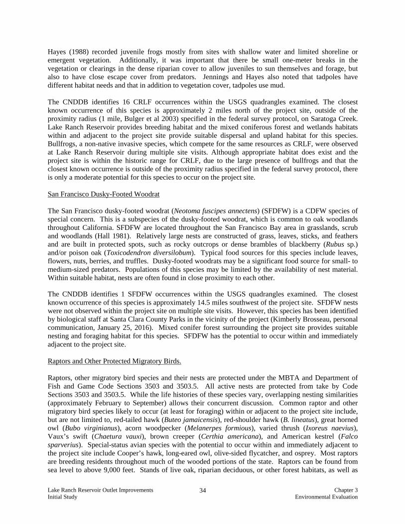
The CNDDB identifies 1 SFDFW occurrences within the USGS quadrangles examined. The closest known occurrence of this species is approximately 14.5 miles southwest of the project site. SFDFW nests were not observed within the project site on multiple site visits. However, this species has been identified by biological staff at Santa Clara County Parks in the vicinity of the project (Kimberly Brosseau, personal communication, January 25, 2016). Mixed conifer forest surrounding the project site provides suitable nesting and foraging habitat for this species. SFDFW has the potential to occur within and immediately adjacent to the project site. Raptors and Other Protected Migratory Birds. Raptors, other migratory bird species and their nests are protected under the MBTA and Department of Fish and Game Code Sections 3503 and 3503.5. All active nests are protected from take by Code Sections 3503 and 3503.5. While the life histories of these species vary, overlapping nesting similarities (approximately February to September) allows their concurrent discussion. Common raptor and other migratory bird species likely to occur (at least for foraging) within or adjacent to the project site include, but are not limited to, red-tailed hawk (Buteo jamaicensis), red-shoulder hawk (B. lineatus), great horned owl (Bubo virginianus), acorn woodpecker (Melanerpes formious), varied thrush (Ixoreus naevius), Vaux’s swift (Chaetura vauxi), brown creeper (Certhia americana), and American kestrel (Falco sparverius). Special-status avian species with the potential to occur within and immediately adjacent to the project site include Cooper’s hawk, long-eared owl, olive-sided flycatcher, and osprey. Most raptors are breeding residents throughout much of the wooded portions of the state. Raptors can be found from sea level to above 9,000 feet. Stands of live oak, riparian deciduous, or other forest habitats, as well as

Lake Ranch Reservoir Outlet Improvements Chapter 3 Initial Study Environmental Evaluation
35
open grasslands, are used most frequently. Nesting also occurs in isolated stands of trees adjacent to foraging habitat. Most species nest in tree crotches 10 to 80 feet, but usually 20 to 50 feet, above ground. Breeding occurs between March and August, with peak activity from May through July. Prey for these species include small birds (especially young during the nesting season), small mammals, and some reptiles and amphibians. Many raptor species hunt in open woodland and habitat edges and often in agricultural fields. Potential nesting trees appropriate for many raptor species occur throughout the redwood forest habitat within the project site. Ospreys generally nest in trees adjacent to large bodies of water. The CNDDB identifies 31 raptor and/or other protected migratory bird occurrences including; Cooper’s hawk, tricolored blackbird (Agelaius tricolor), burrowing owl (Athene cunicularia), long-eared owl, black swift (Cypseloides niger), saltmarsh common yellowthroat (Geothlypis trichas sinuosa), purple martin (Progne subis), white-tailed kite (Elanus leucurus), American peregrine falcon (Falco peregrinus anatum), Swainson’s hawk (Buteo swainsoni), and osprey within the USGS quadrangles examined. Trees within and adjacent to the project site provide appropriate nesting habitat for raptors and other protected migratory bird species. There is a moderate potential for several raptor and other protected migratory bird species to occur within and adjacent to the project site.

Lake Ranch Reservoir Outlet Improvements Chapter 3 Initial Study Environmental Evaluation
36
Sensitive Habitats Wetlands and Other Waters of the U.S. Potentially jurisdictional wetlands were documented along the fringe of Lake Ranch Reservoir, where vegetation cover was at least five percent. Additionally wetland features were mapped within the Lake Ranch Reservoir basin in the northwest corner. Approximately 0.5 acres of wetlands were recorded within the study area (refer to Figures 11 and 12). The San Francisco Bay is a navigable water and as such, tributaries conveying waters to it have the potential to be federally jurisdictional. Lake Ranch Reservoir, Lyndon Canyon Creek and the unnamed drainage on the northwest end of Lake Ranch Reservoir are all hydrologically connected to the Guadalupe River, which then empties into San Francisco Bay through Alviso Slough. As a result, wetland within or adjacent to the Lake Ranch Reservoir have the potential to be federally jurisdictional. Typical OHW within the study area was delineated by distinct hydrogeomorphological features, such as shelving of the bank. Within the study area, approximately 0.5 acres of potential other Waters of the U.S. was documented within the Lake Ranch Reservoir basin. An additional 0.03 acre of potential other Waters of the U.S. were documented within Lyndon Canyon Creek and the unnamed drainage on the northwest end of Lake Ranch Reservoir. The project may be authorized under the Nationwide Permit (NWP) Program through the use of NWP #33 (Temporary Construction, Access, and Dewatering). However, if implementation of the project exceeds the thresholds of the NWP Program, the USACE may require issuance of an Individual Permit (IP). Implementation of the project would require issuance of a Water Quality Certification from the San Francisco Bay Region of the RWQCB. Implementation of the project would require the issuance of a Streambed Alteration Agreement (SAA) under Section 1600-1607 of the California Department of Fish and Game Code. Tree Survey A tree survey was completed for the project by Monarch Consulting Arborists, LLC (March 31, 2015). This report is contained in Appendix C and the results are summarized below. The project area is comprised of a native woodland environment with a mixture of trees and shrubs typically of the region. The tree survey evaluated trees within the proposed outlet alignments. The tree survey identified trees protected by the County of Santa Clara under Municipal Code Division C16 Tree Preservation and Removal. The trees surveyed consist of 26 trees of five different species. Most of trees are bay laurels (16) and big leaf maple (five). The site also contains two Douglas fir, two willows, and one interior live oak. Refer to Appendix C for additional details on the trees inventoried.

!(!(!(
!(!(!(
!(
!(!(
!(
!(
5
10
46
911
12
87
OHW
OHW
Denise Duffy and Associates, Inc.Monterey | San Jose
Environmental Consultants Resource Planners947 Cass Street, Suite 5
Monterey, CA 93940(831) 373-4341
Scale:
Project:
Date: Figure
!( Data Locations
Approximate New Outlet Pipe LocationSurvey AreaOther Waters of the U. S.Potentially Juridictional Wetland
Service Layer Credits: Source: Esri,
8/12/20151 inch = 76 feet
2014-39Document Path: C:\GIS\GIS_Projects\2014-39 Lake Ranch\Map Products\ADIS\Figure 11 Wetland Delineation Saratoga.mxd
0 75 15037.5 FeetU
Lake Ranch Reservoir Dam Rehabilitation JurisidcitionalWetland Delineation - Saratoga Dam Map 11

!(!(!(
!(!(!(!(!(
1
23
OHWOHWOHW
OHWOHW
Denise Duffy and Associates, Inc.Monterey | San Jose
Environmental Consultants Resource Planners947 Cass Street, Suite 5
Monterey, CA 93940(831) 373-4341
Scale:
Project:
Date: Figure
!( Data Locations
Approximate New Outlet Pipe and LocationSurvey AreaOther Waters of the U. S.Potentially Jurisdictional Wetland Service Layer Credits: Source: Esri,
8/12/20151 inch = 39 feet
2014-39Document Path: C:\GIS\GIS_Projects\2014-39 Lake Ranch\Map Products\ADIS\Figure 12 Wetland Delineation Beardsley.mxd
0 40 8020 Feet
U
Lake Ranch Reservoir Dam Rehabilitation JurisidcitionalWetland Delineation Beardsley Dam Map 12
!(
!(!(
!(!(
OHW
OHWOHW
OHWOHW

Lake Ranch Reservoir Outlet Improvements Chapter 3 Initial Study Environmental Evaluation
39
Impacts and Mitigation Thresholds per CEQA Checklist
ENVIRONMENTAL IMPACTS
Potentially Significant
Issues
Potentially Significant
Unless Mitigation
Incorporated
Less Than Significant
Impact
No Impact
ChecklistSource(s)
4. BIOLOGICAL RESOURCES. Would the project:
a) Have a substantial adverse effect, either directly or through habitat modifications, on any species identified as a candidate, sensitive, or special-status species in local or regional plans, policies, or regulations, or by the California Department of Fish and Game or U.S. Fish and Wildlife Service?
X 6
b) Have a substantial adverse effect on any riparian habitat or other sensitive natural community identified in local or regional plans, policies, regulations or by the California Department of Fish and Game or U.S. Fish and Wildlife Service?
X 6
c) Have a substantial adverse effect on federally protected wetlands as defined by Section 404 of the Clean Water Act (including, but not limited to, marsh, vernal pool, coastal, etc.) through direct removal, filling, hydrological interruption, or other means?
X 6
d) Interfere substantially with the movement of any native resident or migratory fish or wildlife species or with established native resident or migratory wildlife corridors, or impede the use of native wildlife nursery sites?
X 6
e) Conflict with any local policies or ordinances protecting biological resources, such as a tree preservation policy or ordinance?
X 6, 8
f) Conflict with the provisions of an adopted Habitat Conservation Plan, Natural Community Conservation Plan, or other approved local, regional or state habitat conservation plan?
X 6
Explanation a) Less Than Significant with Mitigation Incorporated. Several special-status species have the
potential to occur within or adjacent to the project site. Potential presence, possible impacts that could occur due to the project, and mitigation necessary to reduce these impacts to less-than-significant are described below for each species.
California Red-Legged Frog
CRLF have at least a moderate potential to occur at Lake Ranch Reservoir and within the survey area. If CRLF are present at Lake Ranch Reservoir all life stages of the CRLF may utilize the open water habitat associated with Lake Ranch Reservoir. Additionally, adult and juvenile CRLF may utilize the wetland, mixed coniferous forest and annual grassland/ruderal habitat within the survey area as upland/dispersal habitat. Demolition of the existing and installation of the new outlet structures at Saratoga and Beardsley dams, including the installation of a coffer dam for dewatering, may result in impacts to CRLF. Impacts include direct mortality of an individual

Lake Ranch Reservoir Outlet Improvements Chapter 3 Initial Study Environmental Evaluation
40
from equipment and ground disturbance to habitat destruction. This is considered a potentially significant impact that can be reduced to a less-than-significant level with implementation of mitigation measures identified below.
The presence of California red-legged frog has not been determined at this time. No CRLF were observed during site visits; however CRLF may utilize the open water habitat associated with Lake Ranch Reservoir. Additionally, adult and juvenile CRLF may utilize the wetland, mixed coniferous forest, and annual grassland/ruderal habitat within the study area as upland/dispersal habitat. If CRLF are present within the area, demolition and construction activities for the outlet structures at Saratoga and Beardsley dams, including the installation of a coffer dam for dewatering for the Beardsley dam, may result in impacts to CRLF. Impacts include direct mortality of an individual from equipment and ground disturbance to habitat destruction. This is considered a potentially significant impact that can be reduced to a less-than-significant level with implementation of the mitigation identified below.
Mitigation BIO-1A Prior to construction activities, a qualified biologist shall conduct an Employee
Education Program for the construction crew. The biologist shall meet with the construction crew at the project site at the onset of construction to educate the construction crew on the following: 1) a review of the project boundaries; 2) the special-status species that may be present, their habitat, and proper identification; 3) the specific mitigation measures that will be incorporated into the construction effort, 4) the general provisions and protections afforded by the Service and the Department; and 5) the proper procedures if a special-status species is encountered within the project site. An instructional pamphlet shall be included with the Employee Education Program and additional copies will be left for construction personnel that join the project construction effort after the Employee Education Program has been conducted. At the completion of the Employee Education Program the qualified biologist will define someone on-site (generally the project foreman) who will ensure that new construction members receive and review the pamphlet information. The on-site monitor shall also be the primary point of contact in the event that special-status species are found on-site and the presence of the qualified biologist is required.
BIO-1B A qualified biologist shall conduct one daytime survey for CRLF within 48 hours
prior to initiation of project activities.
1. If no CRLF are found within or immediately adjacent to the project site, the project may proceed as planned.
2. If CRLF or the eggs or larvae, are found within the project site a qualified
biologist will implement the following measures:
a. A survey will be conducted each morning prior to the initiation of construction activities.
i. If eggs or larvae are found during the survey effort, a buffer zone
will be established around the location of the eggs/larvae and work may proceed outside of the buffer zone. Work within the buffer zone will be postponed until the eggs have hatched and/or the larvae have

Lake Ranch Reservoir Outlet Improvements Chapter 3 Initial Study Environmental Evaluation
41
metamorphosed. The qualified biologist will determine the buffer size based on the specific conditions of the site and the construction activities proposed.
ii. If adults or non-larval juvenile CRLF are found and cannot be avoided, the individuals will be captured and relocated by a qualified biologist (with Service and/or Department approval) and work may proceed.
BIO-1C A Site Assessment Report for CRLF shall be prepared according to the published
guidelines for the species and submitted to the Service. If the Service determines that the CRLF has the potential to occur within the project site, protocol-level surveys in accordance with the Revised Guidance on Site Assessments and Field Surveys for the California Red-legged Frog (Service and DFW, 2005) may be required. These surveys typically include two day and four night surveys during the breeding season and one night and one day survey during the non-breeding season. If CRLF are found on the site during the surveys and/or it is determined the project will result in take of this species, formal consultation with the Service shall be initiated and an Incidental Take Permit shall be acquired from the Service. Procurement of the Incidental Take Permit would be facilitated under Section 7 when applying for the 404 CWA permit from the Army Corps of Engineers.
Western Pond Turtle WPT are known to occur at Lake Ranch Reservoir and within the survey area. WPT are likely to occur within the open water of Lake Ranch Reservoir. Additionally, adult WPT may utilize the wetland and annual grassland/ruderal habitat within the survey area as nesting habitat. Demolition of the existing and installation of the new outlet structures at Saratoga and Beardsley Dams may result in impacts to WPT. Impacts include direct mortality of an individual from equipment and ground disturbance, nest destruction and habitat destruction. This is considered a potentially significant impact that can be reduced to a less-than-significant level with implementation of mitigation measures identified below.
Mitigation BIO-2A Information on WPT shall be included in the Employee Education Program, as
detailed in Mitigation Measure BIO-1A. BIO-2B A qualified biologist will conduct one daytime survey for WPT within 48 hours
before the initiation of project activities.
1. If no WPT are found within or immediately adjacent to the project site, the project may proceed as planned.
2. If WPT, or the eggs, are found within the project site a qualified biologist will implement the following measures:
a. A survey will be conducted each morning prior to the initiation of
construction activities. b. If an active WPT nest is detected within the project site, a 50-foot buffer
zone around the nest will be established and maintained during breeding
Lake Ranch Reservoir Outlet Improvements Chapter 3 Initial Study Environmental Evaluation
42
and nesting season (April 1-August 31). The buffer zone will remain in place until the young have left the nest, as determined by a qualified biologist.
c. If adults or juvenile WPT are found and cannot be avoided, the individuals will be captured and relocated by a qualified biologist (with Service and/or Department approval) and work may proceed.
Raptors and Other Protected Migratory Birds Raptors and other protected migratory birds have the potential to nest in the mixed conifer forest habitat located within and adjacent to the survey area. Additionally emergent wetland, open water and annual grassland/ruderal habitats provide foraging habitat for these species. Construction activities associated with the implementation of the project, including ground disturbance and the use of heavy machinery, have the potential to impact these species by resulting in nest abandonment. This is considered a potentially significant impact that can be reduced to a less-than-significant level with implementation of mitigation measures identified below. Mitigation BIO-3A Information on raptors and other protected migratory birds shall be included in
the Employee Education Program, as detailed in Mitigation Measure BIO-1A. BIO-3B To avoid impacts to nesting raptors and other migratory bird species,
construction activities, including vegetation removal shall be scheduled outside of the breeding season (February 15 through August 1). If this is not possible, pre-construction surveys shall be conducted for nesting raptors and/or other migratory bird species in all areas that may provide suitable nesting habitat that exist in or within 300 feet of the project boundary by a qualified biologist within 15 days prior to the commencement of construction activities. If protected nesting bird species are identified during pre-construction surveys, an appropriate buffer will be imposed within which no construction activities or disturbance will take place (generally 300 feet in all directions). The exact diameter of the buffer will dependent upon consultation with a qualified biologist and the project/site specific conditions at each nest location. A qualified biological monitor shall be on-site during work re-initiation in the vicinity of the nest offset to ensure that the buffer is adequate and that the nest is not stressed and/or abandoned. No work may proceed within the designated buffer zone of an active nest until such time as all young are fledged, or until after August 1 (when young are assumed fledged).
San Francisco Dusky-Footed Woodrat San Francisco dusky-footed woodrats have the potential to nest in the mixed conifer forest habitat located within and adjacent to the survey area. Additionally emergent wetland, open water and annual grassland/ruderal habitats provide foraging habitat for these species. Construction activities associated with the implementation of the project, including ground disturbance and the use of heavy machinery, have the potential to impact these species by resulting in individual mortality, nest destruction, and nest abandonment. This is considered a potentially significant impact that can be reduced to a less-than-significant level with implementation of mitigation measures identified below.

Lake Ranch Reservoir Outlet Improvements Chapter 3 Initial Study Environmental Evaluation
43
Mitigation BIO-4A Information on San Francisco dusky-footed woodrats shall be included in the
Employee Education Program, as detailed in Mitigation Measure BIO-1A. BIO-4B A qualified biologist shall conduct a pre-construction survey between 30-60 days
prior to any surface disturbing actions for San Francisco dusky-footed woodrat nests. All nests shall be identified and their locations mapped and flagged to be avoided during construction activities
BIO-4C In the event, a dusky-footed woodrat house is found, and assuming the house is
of the San Francisco dusky-footed woodrat sub-species, one of the following avoidance/minimization measures will be implemented. These measures are listed in order of priority, where the first measure is the preferred measure to be implemented as it provides the least amount of impact to the woodrat. If the first measure cannot be implemented due to extenuating site conditions, the second shall be implemented and so forth down the list.
i. The development will be rerouted/re-sited if possible, to avoid the
woodrat house by at least 50 feet. ii. Safety and/or silt fencing will be erected around all houses within 25 feet
of the grading and construction activities to avoid impacts during site work.
iii. In the event, the project footprint must go directly through or within 5 feet of a house, CDFW shall be consulted with one of the two following options:
a. If the house appears inactive (e.g. no scat or fresh leaves and twigs), dismantle the house and replace the lost resource by building an artificial house, subject to CDFW approval. One artificial house shall be built for every one existing inactive house that is dismantled.
b. If the house appears active: 1) trap the occupant(s) of the house, 2) dismantle the house, 3) construct a new artificial house with the materials from the dismantled house, and 4) release the occupant into the new artificial house, subject to CDFW approval. The new house shall be placed no more than 20 feet from its original location and as far from the project footprint as necessary to be protected from excavation, grading and construction activities. In the event, trapping has occurred for three consecutive nights and no woodrats have been captured, the house should be dismantled and a new house constructed Houses shall only be moved in the early morning during the non-breeding season (October through February).
b) Less Than Significant with Mitigation Incorporated. Approximately 0.5 acre of wetlands
occurs within the project survey area. Demolition of the existing outlet structures and installation of new outlet structures would result in temporary impacts to wetlands. Temporary impacts could include grading for access to the construction areas and the removal and disturbance of soils and vegetation associated with construction activities. This is a potentially significant impact that can

Lake Ranch Reservoir Outlet Improvements Chapter 3 Initial Study Environmental Evaluation
44
be reduced to a less-than-significant level with implementation of mitigation measures identified below.
Mitigation
BIO-5 To minimize potential impacts, construction activities shall be limited to the smallest area
possible. Standard BMPs will be followed during pipeline removal and installation, including those designed for with erosion control, sediment control, and spill prevention, to minimize any potential of impacting redwood forest. Project site conditions shall be returned to pre-existing conditions following the completion of all construction activities
c) Less Than Significant with Mitigation Incorporated. Approximately 0.5 acre of potentially
jurisdictional wetlands and 0.5 acre of Other Waters of the U.S. occur within the project survey area. Demolition of the existing outlet structures and installation of new outlet structures would result in temporary impacts to wetlands and other waters of the United States. Temporary impacts could include grading for access to the construction areas and the removal and disturbance of soils and vegetation associated with construction activities. This is considered a potentially significant impact that can be reduced to a less-than-significant level with implementation of mitigation measures identified below.
Mitigation
BIO-6 Implementation of the project will require the issuance of permits from all relevant
regulatory agencies, including a CWA Section 404 permit from the ACOE, CWA Section 401 permit from the RWQCB, and a Fish and Game Code Section 1600-1607 Streambed Alteration Agreement from the Department. Some or all of these permits may require the project proponent to comply with additional avoidance and minimization measures.
d) Less Than Significant Impact. Project activities are expected to temporarily impact wildlife
movement within areas that are under construction. Noise and disturbance associated with construction activities could cause species that commonly use habitats in the project site for dispersal to at least temporarily avoid dispersal through the project site. These effects would be temporary, and once construction activities are complete, wildlife movement conditions would be similar to pre-existing conditions.
e) Less Than Significant Impact. The project will require the removal of three trees, two bay
laurels and one Douglas fir. Seven trees are located in close proximity to construction activities and could be impacted. The project will incorporate tree protection measures during construction to preserve these trees and set forth in the arborist report (Appendix C). This includes wrapping the trees with straw wattle around the main stems to help prevent mechanical damage. No tree protection fence would be required for this project and it is not practical in this situation. Trees that are to be removed would be left on site with all limbs chipped and trunks secured on the ground to continue to provide wildlife habitat. In addition, any brush chips would be directed back into the woodland area and kept onsite. Tree removal for the project is exempt from permitting according to Santa Clara County Ordinance C16-4. Exceptions Section (f) “Maintenance Work within Public Utility Easements.”
f) No Impact. The project site is located outside the boundaries of the Santa Clara Valley Habitat
Conservation Plan boundary. There are no other Habitat Conservation Plans, Natural Community Conservation Plans, or other approved local, regional, or state habitat conservation plans located within the project boundaries or vicinity.

Lake Ranch Reservoir Outlet Improvements Chapter 3 Initial Study Environmental Evaluation
45
E. CULTURAL RESOURCES Setting
A cultural resources evaluation was performed for the project site by Holman & Associates (July 2015), which is available for review at the Santa Clara County Parks office for qualified individuals. This study was prepared to determine the potential for cultural resources on the project site and describes the results of an archival records search, field review of the project site, and findings. An archaeological literature review was conducted at the Northwest Information Center (NWIC file no. 14-03331). The records search indicates that there are no recorded historic and/or prehistoric sites located in the project area or within a one-mile radius. The nearest archaeological field studies were limited to the Highway 9 corridor. A visual inspection of the project area was conducted on July 10, 2015. The survey was conducted for all open ground, starting at the reservoir water’s edge extending to the access road and dam areas to the tree line. No evidence of historic and/or prehistoric archaeological resources was found during the field inspection. Given that the area was historically graded for construction of the reservoir, topsoil that may have held evidence of Native American camps and/or villages have been removed. In addition, the project area would not have supported any kind of habitation in aboriginal times due to its remote location away from seasonal Native American villages (such as those once found in the Lexington Reservoir area). The area also lacks any exposed bedrock that could have been used for seed grinding station or repositories for rock art. Based on the results of the cultural resources evaluation, no evidence of historic and/or prehistoric use was found within the project area. Impacts and Mitigation Thresholds per CEQA Checklist
ENVIRONMENTAL IMPACTS
Potentially Significant
Issues
Potentially Significant
Unless Mitigation
Incorporated
Less Than Significant
Impact
No Impact
ChecklistSource(s)
5. CULTURAL RESOURCES. Would the project:
a) Cause a substantial adverse change in the significance of a historical resource as defined in CEQA 15064.5? X 9
b) Cause a substantial adverse change in the significance of an archaeological resource pursuant to CEQA 15064.5? X 9
c) Directly or indirectly destroy a unique paleontological resource or site or unique geologic feature? X 1,2
d) Disturb any human remains, including those interred outside of formal cemeteries? X 1,2
Explanation
a) No Impact. Based on the results of the cultural resources evaluation, no evidence of historic
and/or prehistoric use was identified within the project area. The evaluation, thus, concluded that

Lake Ranch Reservoir Outlet Improvements Chapter 3 Initial Study Environmental Evaluation
46
the project would have no effect on cultural resources and no further research or monitoring was recommended.
b) Less Than Significant Impact. The cultural resource evaluation concluded that construction of
the reservoir outlet improvements are not expected to affect historic and/or prehistoric materials. The cultural resource evaluation did not identify any further recommendations. The following requirement will be incorporated into the project plans and specifications in the unlikely event that buried cultural resources are encountered during construction:
“Should evidence of prehistoric cultural resources be discovered during construction, work within 50 feet of the find shall be stopped to allow adequate time for evaluation and mitigation by a qualified professional archaeologist. If evidence of any archaeological, cultural, and/or historical deposits is found, hand excavation and/or mechanical excavation shall proceed to evaluate the deposits for determination of significance as defined by CEQA guidelines. The archaeologist shall submit reports, to the satisfaction of the City’s Environmental Principal Planner, describing the testing program and subsequent results. These reports shall identify any program mitigation that the developer shall complete in order to mitigate archaeological impacts (including resource recovery and/or avoidance testing and analysis, removal, reburial, and duration of archaeological resources).”
c) No Impact. The project site is not located in an area of any known or recorded paleontological resources and no impact to such resources is anticipated.
d) Less Than Significant Impact. The project is not expected to encounter human remains. In the unlikely event that human remains are discovered during excavation activities, the following measure will be incorporated into project plans and specifications to avoid impacts associated with disturbance to such remains:
“Pursuant to Section 7050.5 of the Health and Safety Code, and Section 5097.94 of the Public Resources Code of the State of California, in the event of the discovery of human remains during construction, there shall be no further excavation or disturbance of the site or any nearby area reasonably suspected to overlie adjacent remains. The Santa Clara County Coroner shall be notified and shall make a determination as to whether the remains are Native American. If the Coroner determines that the remains are not subject to his authority, he shall notify the Native American Heritage Commission who shall attempt to identify descendants of the deceased Native American. If no satisfactory agreement can be reached as to the disposition of the remains pursuant to this State law, then the land owner shall re-inter the human remains and items associated with Native American burials on the property in a location not subject to further subsurface disturbance.”
F. GEOLOGY AND SOILS Setting The following discussion is based on the geotechnical investigation performed for the proposed reservoir outlet improvements by GEI Consultants (March 2015), contained in Appendix D. The site is on the northeastern flank of the northern Santa Cruz Mountains, about two miles south of Saratoga. The northwest-trending San Andreas Fault zone is mapped along the eastern margin of the reservoir and juxtaposes metasedimentary and metavolcanic rocks of the Jurassic-Cretaceous Franciscan Complex on the northeast against younger, Tertiary-age marine sedimentary rocks on the southwest.

Lake Ranch Reservoir Outlet Improvements Chapter 3 Initial Study Environmental Evaluation
47
The reservoir occupies a linear valley that is filled with older alluvium derived from the adjacent east-flowing drainages that extend up to the summit. The slopes above (west of) the reservoir are relatively steep and rugged, and are underlain primarily by marine sandstone and shale, which are Miocene in age. Bedding in these rocks typically strikes northwest, parallel to the regional structure and dips moderately to the southwest and northeast. Slopes on the east side of the reservoir are relatively gentle and formed by a low ridge. These slopes are mapped as older alluvium overlying Tertiary marine shale. Both dams lie (at least partially) on older alluvium. During the 1906 San Francisco earthquake, ground cracks were observed and documented in the Saratoga dam and in the bottom of the reservoir. The cracks were generally described as fissures from 4 - 6 feet wide oriented nearly north and south. The Beardsley dam was severely damaged when the intake pipes at the south end of the reservoir were disconnected and the escaping water undermined a part of the upstream side of the dam. Additionally, a DSOD inspection memorandum dated June 25, 1930, indicates the outlet pipe at the Beardsley dam was also “sheared at a point about on the axis of the dam” during the earthquake and later repaired. Neither of the dams failed during the 1906 earthquake; however, details of the repairs to the Beardsley embankment and outlet pipe are unknown. The 1989 Loma Prieta earthquake occurred southeast of the site in the Santa Cruz Mountains. This earthquake was not accompanied by primary surface fault rupture like the 1906 event, but numerous ground cracks, broken pipes, and other types of secondary ground deformation were documented in the Los Gatos area as a result of this earthquake. No ground deformation was observed or documented at Lake Ranch Reservoir as a result of the 1989 Loma Prieta event. Previous (1974) Borings In June of 1974, the DSOD drilled two borings at the site; one through the Saratoga dam and one through the Beardsley dam. Details of the drilling and sampling methods were not provided in the available documents; however, general field descriptions of the materials encountered are included on the boring logs. The reservoir water level at the time of drilling (at the Beardsley embankment) was 6.3 feet deep. The boring at the Saratoga dam was drilled to a depth of 37 feet, and generally encountered very stiff sandy clays and dense silty sands with varying amounts of gravel. Gravels typically consisted of weathered sandstone fragments. From a depth of about 13 to 18 feet, slightly plastic silt to sandy silt was encountered, overlying a two-foot layer of black organic clay from about 18.5 to 20.5 feet. Below the organic clay, the boring generally encountered dense silty sand with gravel. Groundwater was encountered during drilling at a depth of about 29 feet; prior to backfilling, groundwater was measured at a depth of about 16 feet. At the Beardsley dam, the boring was drilled to a depth of 91 feet. Bedrock was encountered at a depth of about 39 feet. The bedrock was generally described as crushed shale and sandstone. From existing grade to about 12 feet, the boring encountered hard to very stiff clay with weathered sandstone fragments. From about 12 - 21 feet the boring encountered gravelly silty clay described as “locally soupy.” At a depth of about 21 feet, a one-foot layer of loose gravelly silty sand was encountered. From 22 - 39 feet, gravelly clay and clay ranging from soft to very stiff was encountered. Groundwater was encountered during drilling at a depth of about 11 feet. 2015 Geotechnical Investigation The geotechnical investigation for the project included a site reconnaissance, geophysical surveys at both dams, and drilling 13 exploratory borings. The borings were generally located to explore the subsurface conditions along the proposed siphon alignments. Laboratory tests were performed to profile soil and

Lake Ranch Reservoir Outlet Improvements Chapter 3 Initial Study Environmental Evaluation
48
groundwater conditions. The locations of the borings are presented in the geologic map presented in Figures 13 and 14. Borings along the proposed siphon alignment at the Saratoga dam identified a wide range of soil conditions, including silty sands, sandy clays, gravelly sands, clayey sands, and sandy gravel. Borings ND-1 and ND-2 were drilled on the access road near the toe of the embankment. Boring ND-1 encountered medium dense silty sand overlying stiff sandy clay. At a depth of about 21 feet below ground surface (bgs), a loose clayey sand was encountered. Groundwater prior to backfilling was measured at about 17 feet bgs. Boring ND-2 encountered loose silty and clayey sand overlying medium dense gravelly sand to a depth of about 21.5 feet bgs. Groundwater prior to backfilling was at about 16 feet bgs. Boring ND-3 was drilled on the alluvial surface that forms part of the reservoir bottom. This boring encountered about five feet of very soft sandy clay (i.e., mud) overlying medium stiff sandy clay to a depth of about 15.5 feet. Medium dense, silty fine sand was encountered below. Groundwater was encountered less than one foot bgs. Borings ND-4 and ND-7 were drilled on the crest of the dam. Boring ND-4 encountered about five feet of stiff sandy clay overlying about five feet of medium dense clayey sand. From about 10.5 feet to the bottom of the boring (~ 21.5 feet), medium dense gravelly sands and loose to medium dense sands and sandy gravels were encountered. Groundwater prior to backfilling was measured at about 10 feet bgs. Boring ND-7 encountered about 11 feet of medium stiff to stiff sandy clay. From a depth of about 11 feet to 19 feet, medium dense silty and clayey sands. Below this, dense sandy gravel was encountered. Groundwater was encountered during drilling at a depth of about 14 feet. Three additional borings (ND-5, ND-6, and ND-8) were drilled in the in the left side of the dam. These borings generally encountered medium stiff to stiff sandy clay and medium dense clayey sand. Boring ND-6 encountered medium dense gravelly sand below a depth of about 18.5 feet bgs. Boring ND-8 encountered silty fine sand below a depth of about 20.5 feet bgs. Groundwater in borings ND-6 and ND-8 was encountered at a depth of about 19 feet bgs; in boring ND-5, groundwater was encountered at a depth of about 23.5 feet. Information from the borings at the Saratoga dam suggests that the embankment fills range from about 10 feet thick at Boring ND-4 to about 26 feet thick at Boring ND-5. The base of the fill appears to coincide with the bottom of a distinct black clayey sand-sandy clay unit that occurs in all borings except ND-8. The depth to groundwater at the dam ranges from about 10 feet to 24 feet bgs and in most locations appears to coincide with the contact between the embankment and the foundation. Groundwater along the proposed siphon alignment ranges from less than 1 foot (in ND-3) to about 17 feet bgs (in ND-1). Borings along the proposed siphon alignment at the Beardsley dam encountered medium stiff to hard sandy clay soils, with varying amounts of gravel. In Borings SD-1 and SD-2, medium dense fine sands were encountered beneath the sandy clays at a depth of about 20 feet bgs. Groundwater was not encountered in either of these borings. Boring SD-3, drilled on the upstream right abutment, encountered sand and clayey sand below a depth of about nine feet. Groundwater prior to backfilling this boring was measured at about 14 feet bgs. Boring SD-4 encountered sandy clay throughout its extent, with increasing sand content near the bottom of the boring. Groundwater was encountered in this boring at a depth of about 10 feet bgs. Boring SD-5 encountered about 5 feet of medium dense silty sand overlying soft to stiff sandy clay to a depth of about 16 feet. Below 16 feet, medium dense sand was encountered. No groundwater was encountered in this boring. No borings were drilled through the crest of the dam, so it is difficult to estimate the thickness of the embankment fills. The boring made previously by the DSOD encountered bedrock at a depth of about 37 feet on the left side of the dam; however, based on the available historical and topographic information, the depth to the embankment foundation is likely more shallow. Groundwater was encountered at a depth of about 10 - 14 feet.

Denise Duffy and Associates, Inc.Monterey | San Jose
Environmental Consultants Resource Planners947 Cass Street, Suite 5
Monterey, CA 93940(831) 373-4341
Scale:
Project:
Date: Figure
Source: GEI Consultants 2015
Geologic Map and Boring Locations – Saratoga Dam13
2014-39
1 in = 60 ft
7/31/2015
ND-4
ND-7
ND-2
ND-8
ND-6
ND-5
ND-1
DWR-2
ND-38" PL
6" PL
SCALE, FEET
0 25 50 75
DWR-3
SD-2BORING FOR THIS STUDY
BORING BY DWR (1974)
MAJOR CONTOUR -TERRESTRIALMAJOR CONTOUR -BATHYMETRIC
ARTIFICIAL FILL
EXISTING WELL
GEOLOGIC CONTACT(APPROXIMATE)SAN ANDREAS FAULT(1906 TRACE)
NOTES:1. TOPOGRAPHIC AND BATHYMETRIC BASE MAPS
PROVIDED BY SAN JOSE WATER COMPANY.
RESERVOIR SEDIMENTS
YOUNGER ALLUVIUM
OLDER ALLUVIUM
COLLUVIUM
SAN ANDREAS FAULT(1906 TRACE)
PROP. SIPHONALIGNMENT
PROP. SIPHONALIGNMENT

Denise Duffy and Associates, Inc.Monterey | San Jose
Environmental Consultants Resource Planners947 Cass Street, Suite 5
Monterey, CA 93940(831) 373-4341
Scale:
Project:
Date: Figure
Source: GEI Consultants 2015
Geologic Map and Boring Locations – Beardsley Dam14
2014-39
1 in = 30 ft
7/31/2015
SD-3
DWR-3
SD-2
SD-1SD-5
SD-4
6" PL
CC STRIP
WELL (TYP)
SCALE, FEET
0 25 50 75
DWR-3
SD-2BORING FOR THIS STUDY
BORING BY DWR (1974)
MAJOR CONTOUR -TERRESTRIALMAJOR CONTOUR -BATHYMETRIC
ARTIFICIAL FILL
EXISTING WELL
GEOLOGIC CONTACT(APPROXIMATE)SAN ANDREAS FAULT(1906 TRACE)
RESERVOIR SEDIMENTS
YOUNGER ALLUVIUM
OLDER ALLUVIUM
COLLUVIUM
NOTES:1. TOPOGRAPHIC AND BATHYMETRIC BASE MAPS
PROVIDED BY SAN JOSE WATER COMPANY.
SAN ANDREAS FAULT(1906 TRACE)
PROP. SIPHONALIGNMENT
PROP. SIPHONALIGNMENT

Lake Ranch Reservoir Outlet Improvements Chapter 3 Initial Study Environmental Evaluation
51
Thresholds per CEQA Checklist
ENVIRONMENTAL IMPACTS
Potentially Significant
Issues
Potentially Significant
Unless Mitigation
Incorporated
Less Than Significant
Impact
No Impact
ChecklistSource(s)
6. GEOLOGY AND SOILS. Would the project:
a) Expose people or structures to potential substantial adverse effects, including the risk of loss, injury, or death involving:
i) Rupture of a known earthquake fault, as delineated on the most recent Alquist-Priolo Earthquake Fault Zoning Map issued by the State Geologist for the area or based on other substantial evidence of a known fault? Refer to Division of Mines and Geology Special Publication 42.
X 10
ii) Strong seismic ground shaking? X 10
iii) Seismic-related ground failure, including liquefaction? X X 1,2,10
iv) Landslides? X 10
b) Result in substantial soil erosion or the loss of topsoil? X 1,2,10
c) Be located on a geologic unit or soil that is unstable, or that would become unstable as a result of the project, and potentially result in on- or off-site landslide, lateral spreading, subsidence, liquefaction or collapse?
X 10
d) Be located on expansive soil, as defined in Table 18-1-B of the Uniform Building Code (1994), creating substantial risks to life or property?
X 10
e) Have soils incapable of adequately supporting the use of septic tanks or alternative wastewater disposal systems where sewers are not available for the disposal of wastewater?
X 1,2
Explanation ai) Less Than Significant Impact. Surface rupture occurs along lines of previous faulting. The
project site is crossed by the San Andreas Fault and is located within an Alquist-Priolo Earthquake Fault Zone. A site-specific seismic hazard assessment was performed as part of the geotechnical investigation to evaluate the spectral accelerations that may occur on the site during a future earthquake on the San Andreas Fault. The proposed siphon alignment at the Beardsley outlet appears to cross the 1906 trace of the San Andreas Fault. In the vicinity of Lake Ranch Reservoir, the fault has a slip rate of about 0.67 inches per year with a recurrence interval of about 200-400 years (USGS, 1996). During the 1906 (magnitude 7.9), horizontal (right-lateral) ground movements of about 14 inches to 20 inches were documented near Lake Ranch reservoir. The pipeline at the fault crossing is likely to be severely damaged or destroyed during a future ground-rupturing earthquake on the San Andreas Fault. The siphon at the Beardsley outlet has been designed with an emergency siphon (16-inch pipeline) to prevent uncontrolled releases in the event of a ground-rupturing earthquake. Therefore, the project would result in a less-than-significant impact associated with seismic ground rupture.
aii) Less Than Significant Impact. The San Andreas Fault extends across a portion of the reservoir (see Figures 13 and 14). Refer to discussion ai) above. Due to the project’s location in a seismically active region, the proposed reservoir improvements would be subject to strong

Lake Ranch Reservoir Outlet Improvements Chapter 3 Initial Study Environmental Evaluation
52
seismic ground shaking during their design life that would likely damage the proposed structures. The project has been designed in accordance with DSOD requirements and recommendations of the geotechnical investigation to minimize impacts from seismic shaking. This represents a less-than-significant impact.
aiii) Less Than Significant Impact. Liquefaction is a phenomenon in which the strength and stiffness of a soil is reduced, typically during seismic shaking, causing the soils to liquefy. Sands and silty sands are particularly susceptible to liquefaction, and some silts and sensitive clays also exhibit liquefaction-type strength loses. Observations documented from the 1906 earthquake indicate that the deformation of the reservoir’s two dams (ground cracks) was related to surface fault rupture and not liquefaction. In addition, no occurrences of liquefaction-related deformation were documented at or near the site as a result of the 1989 Loma Prieta earthquake. The geotechnical investigation concluded that liquefaction and liquefaction-related phenomenon are not likely to pose a significant hazard to the project. This represents a less-than-significant impact.
aiv) Less Than Significant Impact. No landslides were identified in the geotechnical investigation for the project. If possible future landslides could affect the project site, these landslides would not result in substantial risk of loss, injury, or death associated with the proposed reservoir outlet improvements.
b) Less Than Significant Impact. Site preparation, trenching, and other construction activities would disturb soil and increase erosion. An erosion control plan would be developed and incorporated into final design plans and specifications to avoid impacts related to loss of topsoil. The project contractor will conform to all legal requirements for avoiding erosion and sedimentation to protect water quality including Santa Clara County Code of Ordinance C12-3 Erosion Prevention and Sediment Control Measures.
c) Less-than-Significant Impact. The geotechnical investigation concluded that liquefaction and liquefaction-related phenomenon are not likely to pose a significant hazard to the project. The project is not otherwise located on a geologic unit or soil that is unstable, or that would become unstable as a result of the project.
Based on subsurface conditions observed in the site borings, there may be localized areas that contain groundwater perched on top of the clayey soils. The occurrence of groundwater in the pipeline trenches during construction is possible and recommendations for dewatering are identified in the geotechnical investigation (Appendix D). The project will be constructed in accordance with the recommendations of the geotechnical report; therefore, this represents a less-than-significant impact.
d) Less-than-Significant Impact. The project site is not expected to contain expansive soils. The
proposed reservoir improvements will be designed and constructed in accordance with the geotechnical investigation (Appendix D), thereby avoiding significant impacts associated with onsite soil and geologic conditions.
e) No Impact. The project consists of reservoir improvements and does not involve septic tanks or alternative wastewater disposal systems.

Lake Ranch Reservoir Outlet Improvements Chapter 3 Initial Study Environmental Evaluation
53
G. GREENHOUSE GAS EMISSIONS Setting Various gases in the earth’s atmosphere, classified as atmospheric greenhouse gases (GHGs), play a critical role in determining the earth’s surface temperature. Solar radiation enters the atmosphere from space and a portion of the radiation is absorbed by the earth’s surface. The earth emits this radiation back toward space, but the properties of the radiation change from high-frequency solar radiation to lower-frequency infrared radiation. Greenhouse gases, which are transparent to solar radiation, are effective in absorbing infrared radiation. As a result, this radiation that otherwise would have escaped back into space is retained, resulting in a warming of the atmosphere. This phenomenon is known as the greenhouse effect. Among the prominent GHGs contributing to the greenhouse effect, or climate change, are carbon dioxide (CO2), methane (CH4), ozone (O3), water vapor, nitrous oxide (N2O), and chlorofluorocarbons (CFCs). Human-caused emissions of these GHGs in excess of natural ambient concentrations are responsible for enhancing the greenhouse effect. In California, the transportation sector is the largest emitter of GHGs, followed by electricity generation. Impacts and Mitigation Thresholds per CEQA Checklist
ENVIRONMENTAL IMPACTS
Potentially Significant
Issues
Potentially Significant
Unless Mitigation
Incorporated
Less Than Significant
Impact
No Impact
Source(s)
7. GREENHOUSE GAS EMISSIONS. Would the project: a) Generate greenhouse gas emissions, either directly or
indirectly, that may have a significant impact on the environment?
X 1, 2, 4
b) Conflict with an applicable plan, policy, or regulation adopted for the purpose of reducing the emissions of greenhouse gases?
X 1, 2, 4
Explanation a) Less Than Significant Impact: Construction of the reservoir outlet improvements will not
generate any permanent new vehicle trips or other sources of GHG emissions. During construction, GHG emissions would be generated by construction vehicles and equipment. Given its small scale and limited construction duration, the project would not contribute GHG emissions that would have a significant impact on the environment.
b) Less Than Significant Impact: As described in a) above, the project will not generate substantial GHG emissions and, therefore, will not conflict with an applicable plan, policy or regulation adopted for the purpose of reducing the emissions of greenhouse gases.
H. HAZARDS AND HAZARDOUS MATERIALS Setting The project site lies in a relatively remote location within Sanborn County Park in the Santa Cruz Mountains. The project site has been occupied by the reservoir since the 1870’s. The site does not

Lake Ranch Reservoir Outlet Improvements Chapter 3 Initial Study Environmental Evaluation
54
contain any known hazardous materials contamination, nor is any expected given the site’s location and historic use as a reservoir. Impacts and Mitigation Thresholds per CEQA Checklist
ENVIRONMENTAL IMPACTS
Potentially Significant
Issues
Potentially Significant
Unless Mitigation
Incorporated
Less Than Significant
Impact
No Impact
ChecklistSource(s)
7. HAZARDS AND HAZARDOUS MATERIALS. Would the project:
a) Create a significant hazard to the public or the environment through the routine transport, use, or disposal of hazardous materials?
X 1, 2
b) Create a significant hazard to the public or the environment through reasonably foreseeable upset and accident conditions involving the release of hazardous materials into the environment?
X 1, 2
c) Emit hazardous emissions or handle hazardous or acutely hazardous materials, substances, or waste within ¼ mile of an existing or proposed school?
X 1, 2
d) Be located on a site which is included on a list of hazardous materials sites compiled pursuant to Government Code Section 65962.5 and, as a result, would it create a significant hazard to the public or the environment?
X 1, 2
e) For a project located within an airport land use plan or, where such a plan has not been adopted, within two miles of a public airport or public use airport, would the project result in a safety hazard for people residing or working in the project area?
X 1, 2
f) For a project within the vicinity of a private airstrip, would the project result in a safety hazard for people residing or working in the project area?
X 1, 2
g) Impair implementation of or physically interfere with an adopted emergency response plan or emergency evacuation plan?
X 1, 2
h) Expose people or structures to a significant risk of loss, injury or death involving wildland fires, including where wildlands are adjacent to urbanized areas or where residences are intermixed with wildlands?
X 1, 2
Explanation a) No Impact. Rehabilitation of the reservoir outlets will not involve an increase in the routine
transport, use, or disposal of hazardous materials.
b) Less Than Significant Impact. The project is located in a rural area with no reported or anticipated sources of hazardous material contamination. The reservoir improvements would not introduce hazardous materials onto the site. However, it is possible that hazardous materials such as fuels, oils, grease, and lubricants from equipment could be accidentally released during construction. As described in Section 2.4, the project includes best management practices to
Lake Ranch Reservoir Outlet Improvements Chapter 3 Initial Study Environmental Evaluation
55
assure that hazardous materials are properly managed during construction. These include the following:
• Equipment and materials for cleanup of spills will be available on the project site at all times
and spills and leaks will be cleaned up immediately and disposed of in accordance with all regulatory requirements.
• All equipment used in the reservoir will be inspected leaks each day prior to initiation of
work and action taken to repair leaks prior to use.
• Building materials, including chemicals and sediment, will not be stockpiled or stored where they could spill into the reservoir or the nearby drainages.
c) No Impact. The project site is not located within ¼ mile of any schools.
d) No Impact. The site is not located on the referenced list of hazardous materials sites compiled pursuant to Government Code Section 65962.5.
e)-f) No Impact. The project site is not located within two miles of any airports and the proposed improvements would not otherwise create a safety hazard for people in the project area.
g) No Impact. Implementation of the proposed project would not interfere with any evacuation plans.
h) Less Than Significant Impact. The entire project site is located within a “Very High Zone, Wildland Urban Interface” area as defined by Santa Clara County. Chapter 7A of the County Building Code and Chapter 49 of the County Fire Code list the requirements for a proposed project, including specific guidelines for construction located within this zone. Rehabilitation of the reservoir outlets will not affect wildland fire potential.
I. HYDROLOGY AND WATER QUALITY Setting Lake Ranch Reservoir lies between two watersheds: Saratoga Creek Watershed to the northwest and Lyndon Canyon Watershed to the southeast. Lake Ranch Reservoir collects runoff from the hillslopes that surround the reservoir as well as an unnamed tributary to Saratoga Creek, whose flows can be diverted via gates controlled by the SJWC. The catchment area of Lake Ranch Reservoir is approximately 571 acres. The storage capacity is approximately 215 acre-feet, with a surface area of approximately 23 acres, when full (1,840 above mean sea level). The reservoir has outlets at both ends that discharge to an unnamed tributary to Sanborn Creek to the north and Lyndon Canyon Creek to the south. Lyndon Canyon Creek (also known as Beardsley Creek) flows southeast eventually connecting to Lexington Reservoir, which empties through Los Gatos Creek, a tributary of Guadalupe River. Guadalupe River ultimately drains into San Francisco Bay via Alviso Slough. The unnamed tributary connects to Sanborn Creek at Ambrose Road. Sanborn Creek is a tributary to Saratoga Creek, which also eventually drains to Guadalupe River. Construction in Santa Clara County is subject to the conditions of the National Pollutant Discharge Elimination System (NPDES) Permit. The objective of the NPDES program is to control and reduce pollutants entering water bodies from non-point discharges. The program is administered by Regional Water Quality Control Boards (RWQCBs) throughout California.

Lake Ranch Reservoir Outlet Improvements Chapter 3 Initial Study Environmental Evaluation
56
The San Francisco Bay Area RWQCB issues NPDES point source permits for discharges from major industries and non-point source permits for discharges to water bodies in the Bay Area for municipalities and other local government entities. The project area is currently covered by the California Regional Water Quality Control Board San Francisco Bay Region Municipal Regional Stormwater NPDES Permit (MRP). Impacts and Mitigation Thresholds per CEQA Checklist
ENVIRONMENTAL IMPACTS
Potentially Significant
Issues
Potentially Significant
Unless Mitigation
Incorporated
Less Than Significant
Impact
No Impact
ChecklistSource(s)
8. HYDROLOGY AND WATER QUALITY. Would the project:
a) Violate any water quality standards or waste discharge requirements? X 1, 2
b) Substantially deplete groundwater supplies or interfere substantially with groundwater recharge such that there would be a net deficit in aquifer volume or a lowering of the local ground water table level (for example, the production rate of pre-existing nearby wells would drop to a level which would not support existing land uses or planned uses for which permits have been granted)?
X 1, 2
c) Substantially alter the existing drainage pattern of the site or area, including through the alteration of the course of a stream or river, in a manner which would result in substantial erosion or siltation on- or off-site.
X 1, 2
d) Substantially alter the existing drainage pattern of the site or area, including through the alteration of the course of a stream or river, or substantially increase the rate or amount of surface runoff in a manner that would result in flooding on- or off-site?
X 1, 2
e) Create or contribute runoff water which would exceed the capacity of existing or planned storm water drainage systems or provide substantial additional sources of polluted runoff?
X 1, 2
f) Otherwise substantially degrade water quality? X 1, 2
g) Place housing within a 100-year flood-hazard area as mapped on a federal Flood Hazard Boundary or Flood Insurance Rate Map or other flood hazard delineation map?
X 1, 2
h) Place within a 100-year flood-hazard area structures which would impede or redirect flood flows? X 1, 2
i) Expose people or structures to a significant risk of loss, injury or death involving flooding, including flooding as a result of the failure of a levee or dam?
X 1, 2
j) Inundation by seiche, tsunami, or mudflow? X 1, 2
Explanation a) Less Than Significant with Mitigation Incorporated. Construction and operation of the
proposed project would not violate any water quality standards or waste discharge requirements set forth by the San Francisco RWQCB. Water pollution control measures will be incorporated

Lake Ranch Reservoir Outlet Improvements Chapter 3 Initial Study Environmental Evaluation
57
into the project design to avoid and/or minimize effects on water quality as described in below and in c) and d).
Site preparation and construction activities would disturb soil and could increase siltation to Lyndon Canyon Creek and the unnamed tributary to Sanborn Creek. This is a significant impact that would be reduced to a less-than-significant level with the following mitigation.
Mitigation
HYD-1 In order to avoid water quality impacts, SJWC shall incorporate and implement the following measures, to be included in the final plans and specifications:
• The Santa Clara County’s Building Regulations related to grading as follows: Santa Clara County, California, Code of Ordinances Title C - Construction, Development and Land Use, Division C12 - Subdivisions and Land Development, Chapter III. – Grading, Article 4. - Requirements Part 4. - Responsibility of Permittee.
• The Municipal Regional Stormwater National Pollutant Discharge Elimination
System (NPDES) Permit. b) No Impact. The project would not divert water from groundwater sources or increase
impervious surfaces that would prevent ground water recharge. Therefore, the proposed improvements would not deplete or otherwise adversely affect groundwater supplies or recharge.
c) Less Than Significant Impact. The proposed outlet improvements would not alter the existing drainage pattern of the two drainages on either side of the reservoir. Clearing, grading, and other construction activities have the potential to result in a temporary increase in erosion affecting the quality of storm water runoff during construction activities (refer also to F. Geology and Soils). After construction, disturbed areas would be restored. The project includes best management practices to avoid impacts from erosion and sedimentation of the two drainages.
As described in a) above, the project would be required to comply with the County of Santa Clara Grading Ordinance, including erosion and dust control during site preparation and with the County of Santa Clara Zoning Ordinance requirements for keeping adjacent streets free of dirt and mud during construction. The following BMPs will be implemented to prevent storm water pollution and minimize potential sedimentation during construction:
1. Restriction of grading to the dry season (April 15 through October 15). 2. Utilize on-site sediment control BMPs to retain sediment on the project site. 3. Implement damp street sweeping; 4. Provide temporary cover of disturbed surfaces to help control erosion during
construction. 5. Provide permanent cover to stabilize the disturbed surfaces after construction has been
completed. 6. Provide proper equipment staging and storage.\
d) Less Than Significant Impact. The project would alter the existing drainage pattern of the site or substantially increase the rate or amount of surface runoff in a manner that would result in flooding on- or off-site. By improving the intakes and outfalls of the Lake Ranch Reservoir, the project would reduce the potential risk of flooding from dam failure.
Lake Ranch Reservoir Outlet Improvements Chapter 3 Initial Study Environmental Evaluation
58
e) Less Than Significant Impact. See d) above. Implementation of the proposed project would not create or contribute runoff that would exceed the capacity of existing or planned storm water drainage systems or provide substantial additional sources of polluted runoff.
f) Less Than Significant Impact. The project would not substantially degrade water quality, as described in c) above.
g) No Impact. The project does not propose the development of any housing or other habitable structures in a floodplain.
h) No Impact. The project would not impede or redirect flood flows. By improving the intakes and outfalls of the Lake Ranch Reservoir, the project would reduce the potential risk of flooding (from dam failure).
i) No Impact. Proposed reservoir improvements would not expose people or structures to a significant risk of loss, injury or death involving flooding as a result of the failure of a levee or dam. By improving the intakes and outfalls of the Lake Ranch Reservoir, the project would reduce the potential risk of flooding from dam failure.
j) Less Than Significant Impact. The project site is not located in an area subject to significant seiche or tsunami risk. The project area is in a mountainous region subject to mudflow risks. The project would be constructed during the dry season and would be short-term to avoid mudflow risks to construction workers.
J. LAND USE Setting The project site is designated in the Santa Clara County General Plan as Regional Parks, Existing and zoned HS - Hillside. The Regional Parks designation is applied to park lands of the County, Cities, State of California, and United States government agencies that serve a region-wide population. The reservoir is located within Sanborn County Park and was constructed in the 1870’s prior to park development. Impacts and Mitigation Thresholds per CEQA Checklist
ENVIRONMENTAL IMPACTS
Potentially Significant
Issues
Potentially Significant
Unless Mitigation
Incorporated
Less Than Significant
Impact
No Impact
ChecklistSource(s)
9. LAND USE AND PLANNING. Would the project:
a) Physically divide an established community? X 1,2
b) Conflict with any applicable land use plan, policy, or regulation of an agency with jurisdiction over the project (including, but not limited to the general plan, specific plan, local coastal program, or zoning ordinance) adopted for the purpose of avoiding or mitigating an environmental effect?
X 1,2,4
c) Conflict with any applicable Habitat Conservation Plan or Natural Community Conservation Plan? X 1,2
Lake Ranch Reservoir Outlet Improvements Chapter 3 Initial Study Environmental Evaluation
59
Explanation a) No Impact. The proposed reservoir improvements would not physically divide an established
community.
b) No Impact. The project site is located within Sanborn County Park and is designated Regional Park in the County’s General Plan. The reservoir was constructed in the 1870’s before the park was developed and is compatible with park uses. The reservoir outlet improvements are proposed to meet DSOD requirements and are consistent with the County’s General Plan policies to provide and improve water services to the residents of Santa Clara County. No changes in the general plan, zoning ordinance, or planning document would be required. The project would not conflict with any applicable land use plan, policy, or regulation adopted for the purpose of avoiding or mitigating an environmental effect.
c) No Impact. The project site is located outside the boundaries of the SCVHCP. Refer to D. Biological Resources for further discussion.
K. MINERAL RESOURCES Setting Under the Surface Mining and Reclamation Act of 1975 (SMARA), the State Mining and Geology Board has designated the Hillsdale Rock Company as the operator of Lexington Quarry, a crushed stone operation located about three miles north of the project site. The project site and vicinity do not have mineral deposits subject to SMARA. Impacts and Mitigation Thresholds per CEQA Checklist
ENVIRONMENTAL IMPACTS
Potentially Significant
Issues
Potentially Significant
Unless Mitigation
Incorporated
Less Than Significant
Impact
No Impact
ChecklistSource(s)
10. MINERAL RESOURCES. Would the project:
a) Result in the loss of availability of a known mineral resource that would be of value to the region and the residents of the state?
X 1,2
b) Result in the loss of availability of a locally-important mineral resource recovery site delineated on a local general plan, specific plan, or other land use plan?
X 1,2
Explanation a) No Impact. The project will not result in the loss of availability of a known mineral resource.
b) No Impact. The project would not affect the availability of any mineral resources from mineral recovery sites.

Lake Ranch Reservoir Outlet Improvements Chapter 3 Initial Study Environmental Evaluation
60
L. NOISE Setting Noise is measured in decibels (dB), and is typically characterized using the A-weighted sound level or dBA. This scale gives greater weight to the frequencies to which the human ear is most sensitive. Noise may be defined as unwanted sound. Noise is usually objectionable because it is disturbing or annoying. The objectionable nature of sound could be caused by its pitch or its loudness. Pitch is the height or depth of a tone or sound, depending on the relative rapidity (frequency) of the vibrations by which it is produced. Higher pitched signals sound louder to humans than sounds with a lower pitch. Loudness is intensity of sound waves combined with the reception characteristics of the ear. Intensity may be compared with the height of an ocean wave in that it is a measure of the amplitude of the sound wave. There are no noise sensitive receptors (e.g., residences) in the immediate project vicinity. Impacts and Mitigation Thresholds per CEQA Checklist
ENVIRONMENTAL IMPACTS
Potentially Significant
Issues
Potentially Significant
Unless Mitigation
Incorporated
Less Than Significant
Impact
No
Impact
ChecklistSource(s)
11. NOISE. Would the project result in
a) Exposure of persons to or generation of noise levels in excess of standards established in the local general plan or noise ordinance or applicable standards of other agencies?
X 1, 2
b) Exposure of persons to or generation of excessive ground borne vibration or ground borne noise levels? X 1, 2
c) Substantial permanent increase in ambient noise levels in the project vicinity above levels existing without the project? X 1, 2
d) A substantial temporary or periodic increase in ambient noise levels in the project vicinity above levels existing without the project?
X 1, 2
e) For a project located within an airport land use plan or, where such a plan has not been adopted, within two miles of a public airport or public use airport, would the project expose people residing or working in the project area to excessive noise levels?
X 1, 2
f) For a project within the vicinity of a private airstrip, would the project expose people residing or working in the project area to excessive noise levels?
X 1, 2
Explanation a) Less Than Significant Impact. The project consists of outlet improvements to Lake Ranch
Reservoir. The only noise generated on the site will occur during construction. This will temporarily elevate noise levels in the immediate project area from the use of construction equipment. However, due to the lack of nearby sensitive receptors (e.g., residences), this is a less-than-significant impact. See also d) below.

Lake Ranch Reservoir Outlet Improvements Chapter 3 Initial Study Environmental Evaluation
61
b) Less Than Significant Impact. The reservoir improvements do not include pumps or other mechanical equipment that will generate permanent ground borne vibration or ground borne noise levels.
c) No Impact. No pumps or other noise-generating mechanical equipment is included in the project
that will result in permanent increases in noise levels. The only noise generated on the site will occur during construction. This is addressed under item d) below.
d) Less Than Significant Impact. Construction activities associated with the project will result in
short-term increases in noise. Noise impacts from construction activities depend on the type of construction equipment, the timing and length of activities, the distance between the noise generating construction activities and receptors, and shielding. Estimated noise levels at 25 feet from construction activity are about 84-92 dB. Noise levels attenuate approximately six dB for every doubling of distance. There are no sensitive receptors (e.g., residences) located within the vicinity of the project site; therefore noise abatement measures are not required per CEQA. The project is located along a public trail within the Sanborn County Park, and construction activities may be intermittently audible to park users; however, it is assumed that the public trail adjacent to the reservoir will be closed or re-routed during project construction. Noise generated during construction, therefore, is considered a less-than-significant impact.
e) No Impact. The project is not located within an airport land use plan or near any public airports. f) No Impact. The project is not located near any private airstrips. M. POPULATION AND HOUSING Setting The proposed project does not include development of housing, nor does it include an expansion in water use or services that would affect population or housing characteristics. Impacts and Mitigation Thresholds per CEQA Checklist
ENVIRONMENTAL IMPACTS
Potentially Significant
Issues
Potentially Significant
Unless Mitigation
Incorporated
Less Than Significant
Impact
No Impact
ChecklistSource(s)
12. POPULATION AND HOUSING. Would the project:
a) Induce substantial population growth in an area, either directly (for example, by proposing new homes and businesses) or indirectly (for example, through extension of roads or other infrastructure)?
X 1,2
b) Displace substantial numbers of existing housing, necessitating the construction of replacement housing elsewhere?
X 1,2
c) Displace substantial numbers of people, necessitating the construction of replacement housing elsewhere? X 1,2
Lake Ranch Reservoir Outlet Improvements Chapter 3 Initial Study Environmental Evaluation
62
Explanation a) No Impact. The improvements to the reservoir would not directly or indirectly facilitate growth.
b) No Impact. The improvements to the reservoir displace any existing housing, necessitating the construction of replacement housing.
c) No Impact. The project would not displace any housing or people.
N. PUBLIC SERVICES Setting Lake Ranch Reservoir is operated and maintained by SJWC. The Sheriff’s Department serves the unincorporated areas of Santa Clara County. Fire protection services vary in quality over the rural areas of the Santa Cruz Mountains and most of the rural areas receive seasonal fire protection from CAL FIRE. Impacts and Mitigation Thresholds per CEQA Checklist
ENVIRONMENTAL IMPACTS
Potentially Significant
Issues
Potentially Significant
Unless Mitigation
Incorporated
Less Than Significant
Impact
No Impact
Checklist Source(s)
13. PUBLIC SERVICES. Would the project result in substantial adverse physical impacts associated with the provision of new or physically altered governmental facilities or need for new or physically altered governmental facilities, the construction of which could cause significant environmental impacts, in order to maintain acceptable service ratios, response times, or other performance objectives for any of the public services:
a) Fire protection? X 1,2
b) Police protection? X 1,2
c) Schools? X 1,2
d) Parks? X 1,2
e) Other public facilities? X 1,2
Explanation a)–e) No Impact. The proposed project consists of improvements to an existing reservoir. The project
will not impact fire, police, school, park, or other public services. The reservoir will continue to be operated and maintained by SJWC.
O. RECREATION Setting Lake Ranch Reservoir is located within Sanborn County Park. The park encompasses 3,688 acres of land within the Santa Cruz Mountains between Saratoga and Skyline Boulevard. The park contains camping facilities, hiking trails, and picnic amenities and is open year round from 8 AM to dusk.

Lake Ranch Reservoir Outlet Improvements Chapter 3 Initial Study Environmental Evaluation
63
Impacts and Mitigation Thresholds per CEQA Checklist
ENVIRONMENTAL IMPACTS
Potentially Significant
Issues
Potentially Significant
Unless Mitigation
Incorporated
Less Than Significant
Impact
No Impact
ChecklistSource(s)
14. RECREATION. Would the project:
a) Increase the use of existing neighborhood and regional parks or other recreational facilities such that substantial physical deterioration of the facility would occur or be accelerated?
X 1,2
b) Include recreational facilities or require the construction or expansion of recreational facilities, which might have an adverse physical effect on the environment?
X 1,2
Explanation a) Less Than Significant Impact with Mitigation. The proposed reservoir improvements will not
impact the long-term use of the adjacent John Nicholas Trail, part of the trail system within Sanborn Park. The project will not increase the use of existing neighborhood and regional parks or other recreational facilities such that substantial physical deterioration of the facility would occur. During construction, however, portions of the trail adjacent to the reservoir may be closed or re-routed for safety reasons. This temporary loss of access would result in short-term disruptions to portions of the trail. The following mitigation is identified to reduce this short-term impact to trail users during construction to a less-than-significant level.
Mitigation
REC-1 Signs shall be posted notifying park users of temporary trail closures and alternative trail routes during construction to provide interim trail access during the construction period. If permanent trail access is altered or damaged during construction, then permanent trail access shall be fully restored after construction.
b) No Impact: The project does not include recreational facilities or require the construction or expansion of recreational facilities. See also a) above.
P. TRANSPORTATION Setting SJWC service roads provide access to Lake Ranch Reservoir from the north via Sanborn Road and from the south via Black Road. Public access to Lake Ranch Reservoir is provided only by trails within Sanborn Park. A portion of the John Nicholas Trail extends within the access road along the reservoir’s east boundary.

Lake Ranch Reservoir Outlet Improvements Chapter 3 Initial Study Environmental Evaluation
64
Impacts and Mitigation Thresholds per CEQA Checklist
ENVIRONMENTAL IMPACTS
Potentially Significant
Issues
Potentially Significant
Unless Mitigation
Incorporated
Less Than Significant
Impact
No Impact Source(s)
15. TRANSPORTATION/TRAFFIC. Would the project: a) Conflict with an applicable plan, ordinance or policy
establishing measures of effectiveness for the performance of the circulation system, taking into account all modes of transportation including mass transit and non-motorized travel and relevant components of the circulation system, including but not limited to intersections, streets, highways and freeways, pedestrian and bicycle paths, and mass transit?
X 1, 2
b) Conflict with an applicable congestion management program, including but not limited to level of service standards and travel demand measures, or other standards established by the county congestion management agency for designated roads or highways?
X 1, 2
c) Result in a change in air traffic patterns, including either an increase in traffic levels or a change in location that results in substantial safety risks?
X 1, 2
d) Substantially increase hazards due to a design feature (for example, sharp curves or dangerous intersections) or incompatible uses (for example, farm equipment)?
X 1, 2
e) Result in inadequate emergency access?
X 1, 2
f) Conflict with adopted policies, plans, or programs regarding public transit, bicycle, or pedestrian facilities, or otherwise decrease the performance or safety of such facilities?
X 1, 2
Explanation a) Less Than Significant Impact. Outside of the construction period, the reservoir outlet
improvements will not generate additional traffic. The only vehicle trips that will be generated by the project on a permanent basis will be for maintenance or inspection of facilities, which will be unchanged from current maintenance and inspection activities.
During construction, additional truck traffic will be introduced into the local roadway network. Construction vehicles would access the site from the north service road via Sanborn Road. Sanborn Road carries relatively low traffic volumes. The volume and type of traffic associated with project construction may temporarily increase traffic volumes on roads on the local network; however, this short-term increase in traffic volume is not expected to degrade the level of service on any transportation facilities. As per the construction specifications, the contractor will develop a traffic control plan prior to construction to avoid temporary traffic impacts during construction. The contractor must comply with an approved traffic control plan and be responsible for furnishing, installing and maintaining all warning signs and devices necessary to safeguard the general public and the work, and to provide for the proper and continuous safe routing of vehicular and pedestrian traffic during the performance of the work.
b) Less-than-Significant Impact. See a) above.
c) No Impact. The project will not result in any changes to air traffic patterns.

Lake Ranch Reservoir Outlet Improvements Chapter 3 Initial Study Environmental Evaluation
65
d) No Impact. The project will not substantially increase hazards due to a design feature or incompatible uses.
e) No Impact. The project will not result in inadequate emergency access. f) No Impact. The project will not conflict with adopted policies, plans, or programs regarding
public transit, bicycle, or pedestrian facilities, or otherwise decrease the performance or safety of such facilities.
Q. UTILITIES AND SERVICE SYSTEMS Setting Lake Ranch Reservoir and the proposed reservoir outlet improvements will continue to be operated and maintained by SJWC. Impacts and Mitigation Thresholds per CEQA Checklist
ENVIRONMENTAL IMPACTS
Potentially Significant
Issues
Potentially Significant
Unless Mitigation
Incorporated
Less Than Significant
Impact
No Impact
ChecklistSource(s)
16. UTILITIES AND SERVICE SYSTEMS. Would the project:
a) Exceed wastewater treatment requirements of the applicable Regional Water Quality Control Board? X 1, 2
b) Require or result in the construction of new water or wastewater treatment facilities or expansion of existing facilities, the construction or which could cause significant environmental effects?
X 1, 2
c) Require or result in the construction of new storm water drainage facilities or expansion of existing facilities, the construction of which could cause significant environmental effects?
X 1, 2
d) Have sufficient water supplies available to serve the project from existing entitlements and resources, or are new or expanded entitlements needed?
X 1, 2
e) Result in a determination by the wastewater treatment provider, which serves or may serve the project, that it has adequate capacity to serve the project’s projected demand in addition to the provider’s existing commitments?
X 1, 2
f) Be served by a landfill with sufficient permitted capacity to accommodate the project’s solid waste disposal needs? X 1, 2
g) Comply with federal, state, and local statutes and regulations related to solid waste? X 1, 2
Explanation a) Less Than Significant Impact. The project would comply with discharge permits and
regulations, as applicable.

Lake Ranch Reservoir Outlet Improvements Chapter 3 Initial Study Environmental Evaluation
66
b) Less Than Significant Impact. The project is replacing and improving the existing reservoir
outlet works. As described in this Initial Study, the project will reduce all significant impacts to a less-than-significant level with mitigation incorporated into the project. The project is not an expansion of existing water facilities. In addition, the project does not involve any wastewater facilities.
c) Less Than Significant Impact. The project does not propose any new storm water drainage
facilities or expansion of existing facilities. d) Less Than Significant Impact. Construction of the proposed project may require some minor
amount of water for dust suppression, which will not affect existing water entitlements and resources.
e) No Impact. No wastewater service is required for the project; therefore, the proposed project would have no impact on wastewater treatment providers and related wastewater systems.
f)-g) No Impact. The proposed project would not generate substantial solid waste that would adversely affect any landfills. Materials to be removed by the project will be recycled to the extent feasible.
R. MANDATORY FINDINGS OF SIGNIFICANCE
ENVIRONMENTAL IMPACTS
Potentially Significant
Issues
Potentially Significant
Unless Mitigation
Incorporated
Less Than Significant
Impact
No Impact
Checklist Source(s)
17. MANDATORY FINDINGS OF SIGNIFICANCE. Does the project:
a) Have the potential to degrade the quality of the environment, substantially reduce the habitat of a fish or wildlife species, cause a fish or wildlife population to drop below self-sustaining levels, threaten to eliminate a plant or animal community, reduce the number or restrict the range of a rare or endangered plant or animal or eliminate important examples of the major periods of California history or prehistory?
X 1,2,6,7,9
b) Have impacts that are individually limited, but cumulatively considerable? (“Cumulatively considerable” means that the incremental effects of a project are considerable when viewed in connection with the effects of the past projects, the effects of other current projects, and the effects of probable future projects.)
X 1,2
c) Have environmental effects that will cause substantial adverse effects on human beings, either directly or indirectly?
X 1,2
Explanation a) Less Than Significant Impact with Mitigation Incorporated. Based on the analysis provided
in this Initial Study, the proposed reservoir outlet improvements will not substantially degrade or reduce wildlife species or habitat with implementation of identified mitigation. The cultural resources evaluation for the project concluded that the project would not impact historic or other cultural resources.

Lake Ranch Reservoir Outlet Improvements Chapter 3 Initial Study Environmental Evaluation
67
b) Less Than Significant Impact. Based on the analysis provided in this Initial Study, the proposed
reservoir outlet improvements would not have significant cumulative impacts. All potential impacts of the proposed project would be less-than-significant or reduced to a less-than-significant level with incorporation of mitigation measures. Furthermore, potential impacts of the proposed project are limited to temporary construction activities that would be resolved upon completion of the project.
c) Less Than Significant Impact. As identified in this Initial Study, implementation of the
proposed reservoir outlet improvements would not result in substantial adverse effects on human beings, either directly or indirectly.

Lake Ranch Reservoir Outlet Improvements Chapter 4 Initial Study References
68
Chapter 4. References LEAD AGENCY Santa Clara County Parks Kimberly Brosseau, Acting Senior Planner REPORT PREPARATION Denise Duffy & Associates, Inc. Environmental Consultant Leianne Humble Senior Planner/Project Manager Matt Johnson Associate Environmental Scientist Jami Davis Associate Environmental Scientist Robyn Simpson Administration/Editing
PERSONS CONTACTED Steve Hooper, Waterworks Engineers Ken Schwartz, Horizon Water & Environment Bill Tuttle, SJWC REFERENCES Bay Area Air Quality Management District, 2012. BAAQMD CEQA Guidelines. Bay Area Air Quality Management District, Clean Air Plan, March 2010. Bulger, J.B., N.J. Scott Jr., and R.B. Seymour. 2003. Terrestrial activity and conservation of adult
California red-legged frog Rana aurora draytonii in coastal forests and grasslands. Biological Conservation, Vol. 110. Pp. 85-95.
CNPS, Rare Plant Program. 2015. Inventory of Rare and Endangered Plants (online edition, v8-02). California Native Plant Society, Sacramento, CA. Website http://www.rareplants.cnps.org [accessed 30 July 2015].
Department. 2008. California Wildlife Relationships System: Life History Accounts. Database Version 8.2.
Department. 2010. List of California terrestrial natural communities recognized by the Natural Diversity Database.
Department. 2015a. California Natural Diversity Database Special Animals List. Available online at: http://www.dfg.ca.gov/biogeodata/cnddb/pdfs/SPAnimals.pdf (July 2015).
Department. 2015b. California Natural Diversity DataBase Rare Find Report (May & July 2015).
Ernst, C.H. and R.W. Barbour. 1972. Turtles of the United States. University Kentucky Press, Lexington, KY. 347 pp.

Lake Ranch Reservoir Outlet Improvements Chapter 4 Initial Study References
69
GEI Consultants. April 2015. Geologic/Geotechnical Study, Lake Ranch Reservoir Outlet Pipe Replacement Project.
Hall, E.R. 1981. Mammals f north America. John Wiley and Sons. 1181 pp.
Jennings, M.R. and M.P. Hayes. 1988. Habitat correlates of distribution of the California red-legged frog (Rana draytonii) and the foothill yellow-legged frog (Rana boylii): implications for management. Proceedings form Management of Amphibians, Reptiles and Small Mammals in North America Symposium 1988.
Jennings, M.R. and M.P. Hayes. 1994. Amphibian and reptile species of special concern in California. Final report to the California Department of Fish and Wildlife, Inland Fisheries Division.255 pp.
Jepson Flora Project. 2015. Jepson Online Interchange for California floristics. Available online at: http://ucjeps.berkeley.edu/interchange.html
Rathbun, G.B., M.R. Jennings, T.G. Murphey, and N.R. Siepel. 1993. Status and ecology of sensitive aquatic vertebrates in lower San Simeon and Pico Creeks, San Luis Obispo County, California. Unpublished report, National Ecology Research Center, Pederast Blancas Research Station, San Simeon, California. 103 pp.
Service. 2015. Listed, Proposed, and Candidate Species Which May Occur in Santa Clara County. Available online at: http://www.dfg.ca.gov/biogeodata/cnddb/pdfs/SPAnimals.pdf (July 2015).
Spinks, P.Q. and Shaffer, B. 2005. Range-wide molecular analysis of the western pond turtle (Emys
marmorata): cryptic variation, isolation by distance, and their conservation implications. Molecular Ecology Vol. 14. Pp. 2047–2064.
U.S. Fish and Wildlife Service (Service). 2010. Birds Protected by the Migratory Bird Treaty Act. Available online at: http://www.fws.gov/migratorybirds/RegulationsPolicies/mbta/mbtintro.html
CHECKLIST SOURCES 1. CEQA Guidelines and professional expertise of consultant 2. Project Plan and Site Review 3. BAAQMD CEQA Guidelines 4. Santa Clara County General Plan, 1994 5. Important Farmlands Map, 2015 6. Biological Investigation, 2015 7. Wetland Delineation, 2015 8. Arborist Report, 2015 9. Cultural Resources Evaluation, 2015 10. Geotechnical Investigation, 2015
