lake minnetonka conservation district board of...
TRANSCRIPT

LAKE MINNETONKA CONSERVATION DISTRICT
BOARD OF DIRECTORS
AGENDA
7:00 PM, Wednesday, October 12, 2016
Wayzata City Hall
600 Rice Street, Wayzata, MN 55391
1. CALL TO ORDER
2. PLEDGE OF ALLEGIANCE
3. ROLL CALL
4. APPROVAL OF AGENDA
5. CHAIR ANNOUNCEMENTS, Chair Green
6. APPROVAL OF MINUTES- 9/14/16 LMCD Regular Board Meeting
9/28/16 LMCD Regular Board Meeting
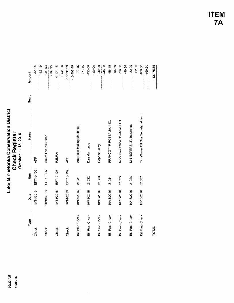
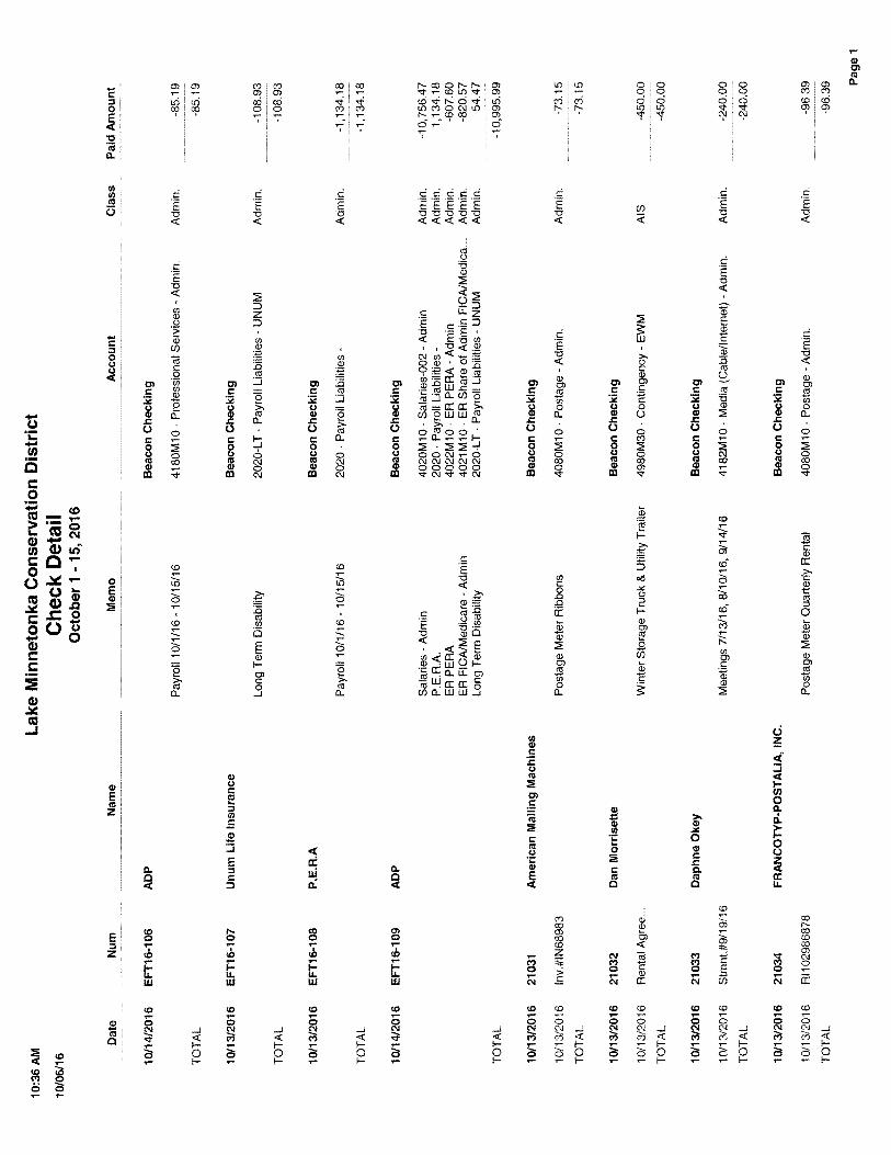
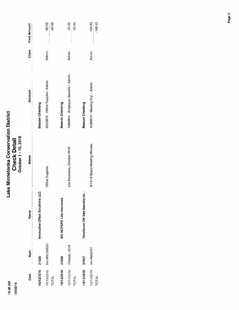
7. APPROVAL OF CONSENT AGENDA A) Audit of vouchers (10/1/16 – 10/15/16)
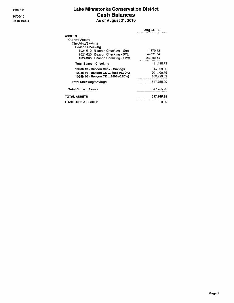
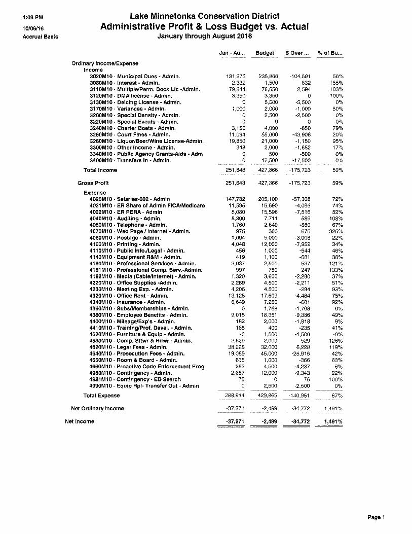
B) August Financial Summary and Balance Sheet
C) 5th
Street Ventures, approval of draft Record of Decision and LMCD Resolution 151 ordering a
negative declaration on the need for an Environmental Impact Statement (EIS) for the Mandatory
Environmental Assessment Worksheet (EAW) document.
D) Approval of draft letter to be forwarded to LMCD Member Cities regarding Board appointments
for 2017
8. PUBLIC COMMENTS- Persons in attendance, subjects not on the agenda (limited to 5 minutes)
9. PUBLIC HEARINGS - None
10. OTHER BUSINESS A) Review and consideration of draft mandatory Environmental Assessment Worksheet (EAW)
City of Excelsior Proposed Multiple Dock and Municipal Planned Unit Development
Browns Bay Marina (Site 2) Proposed Multiple Dock

LMCD Board of Directors
October 12, 2016
Page 2
B) Code amendment options regarding Section 2.015, “Reconfiguration of Non-Conforming
Structures
C) Review draft amendment to the LMCD Investment Policy per Board direction – to be
emailed
11. UPDATE FROM STANDING LMCD COMMITTEES
12. EXECUTIVE DIRECTOR UPDATE
A) Review and input regarding LMCD Facebook page
B) Input regarding continuing the contract with TimeSaver (minute taking)
C) Other
13. OLD BUSINESS
14. NEW BUSINESS
15. ADJOURNMENT

LAKE MINNETONKA CONSERVATION DISTRICT BOARD OF DIRECTORS
7:00 P.M., September 14, 2016 Wayzata City Hall
1. CALL TO ORDER
Chair Green called the meeting to order at 7:00 p.m.
2. PLEDGE OF ALLEGIANCE
3. ROLL CALLMembers present: Jay Green, Mound; Deborah Zorn, Shorewood; Dan Baasen, Wayzata; Ann Hoelscher,Victoria; Gary Hughes, Spring Park; Gabriel Jabbour, Orono; Dennis Klohs, Minnetonka Beach; Bret Niccum,Minnetrista; Gregg Prest, Excelsior; Rob Roy, Greenwood; and Sue Shuff, Minnetonka. Also present: JimBrimeyer, Interim Executive Director; Vickie Schluening, Executive Director; Emily Herman, AdministrativeAssistant; and Kyle Hartnett, Legal Counsel.
Members absent: Chris Jewett, Deephaven; Fred Meyer, Woodland; and, Gregg Thomas, Tonka Bay.
4. APPROVAL OF AGENDA
Green requested Agenda Item 10C be moved to 10A, with the other agenda items moving down accordingly.
MOTION: Niccum moved, Zorn seconded to approve the agenda as amended, making the change noted by Green above.
VOTE: Motion carried unanimously.
5. CHAIR ANNOUNCEMENTS
Green welcomed new Executive Director Vickie Schluening to the Board.
6. APPROVAL OF MINUTES- 8/10/16 LMCD Regular Board Meeting 8/24/16 LMCD Special Board Meeting 8/31/31 LMCD Special Board Meeting (Continued from 8/24/16)
MOTION: Roy moved, Shuff seconded to approve the 8/10/16 LMCD Regular Board Meeting minutes as submitted.
VOTE: Motion carried unanimously.
MOTION: Roy moved, Niccum seconded to approve the 8/24/16 LMCD Special Board Meeting minutes as submitted.
VOTE: Ayes (10), Abstained (1, Zorn); motion carried.
ITEM 6
Lake Minnetonka Conservation District Regular Board Meeting September 14, 2016 Page 2
MOTION: Jabbour moved, Hughes seconded to approve the 8/31/16 LMCD Special Board Meeting minutes as submitted.
VOTE: Motion carried unanimously.
7. APPROVAL OF CONSENT AGENDA
MOTION: Jabbour moved, Zorn seconded to approve the consent agenda as presented. Items so approved
included: 7A) Audit of Vouchers (8/16/16 – 8/31/16) and (9/1/16 – 9/15/16); 7B) July Financial Summary and Balance Sheet; and 7C) Approval of Employment Agreement for Executive Director
VOTE: Motion carried unanimously.
8. PUBLIC COMMENTS- Persons in attendance, subjects not on the agenda (limited to 5 minutes) There were no public comments. 9. PUBLIC HEARING
A) Howard’s Point Marina, new multiple dock license on South Upper Lake to reconfigure storage (utilizing Qualified Commercial Marina Ordinance)
Herman directed the Board to the staff memo, dated 9/9/16, and provided the following overview of this agenda item via a PowerPoint presentation:
An overview of the currently approved license and the recent completion of an Environmental Assessment Worksheet (EAW) that resulted in a negative declaration.
A detailed overview of the proposed changes outlined within the staff memo.
Relevant LMCD Code Sections included Qualified Commercial Marina (Section 1.02, 40a), Dock Use Area Requirements (Section 2.01), Shoreline Requirements (Section 2.02, Subd. 10), and Fuel Sales Facilities (Section 2.03, Subd. 10).
No changes are proposed for the 38 off Lake boat storage units (BSU).
Staff recommends the Board approve the 2017 Howard’s Point Marina Multiple Dock License, subject to conditions outlined within the staff memo.
Green inquired if there was language with other sites that states where customers should board watercraft. Herman stated she would have to research the topic, but it is not uncommon as it offers another level of safety and there is currently not a proposed designated boat storage unit for such use. Zorn inquired what the square footage of the approved plan is. Herman stated she did not have that information, but would provide it to the Board. Niccum referred to the extension of the north dock and the area only being 23’ wide. He asked if people will have assistance backing up their boats from the launching ramp. Herman stated until this date, she
Lake Minnetonka Conservation District Regular Board Meeting September 14, 2016 Page 3
was under the impression the employees would be launching all watercraft. However, it has come to her attention that the ramp is available for the general public for a fee. She would have to defer to the applicant relative to that question. Mr. Richard Baker, owner of Howard’s Point Marina, commented the docks are in need of replacement. In reference to the boat launch area, it is only four feet narrower than it is right now. Zorn asked the applicant if he knew the square footage of the plan. Mr. Baker stated he did not know it. Green opened the public hearing at 7:24 p.m. Mr. Scott Colesworthy, 5480 Howards Point Road, commented he opposes the length of the dock as it negatively impacts his property. Herman stated the proposed dock length is 200’ with an extra 25’ for the fueling facility. Jabbour stated the owner is complying with the ordinance in their proposed request. No additional comments were offered and the public hearing was closed at 7:29 p.m. MOTION: Jabbour moved, Niccum seconded to approve 2017 Howard’s Point Marina Multiple Dock
License subject to staff recommendations. VOTE: Ayes (10); Nays (1, Baasen); motion carried.
10. OTHER BUSINESS
A) The Caribbean Marina, request for additional minimum wake buoy (110 Sunrise Avenue, Tonka Bay, MN) Niccum recommended approval of the request without further discussion. The Chair believed an overview of the request was relevant. Brimeyer directed the Board to the staff memo, dated 9/8/16, and Caribbean Marina’s request for an additional minimum wake buoy. He provided an overview of the request and staff’s recommendations as outlined within his memo. MOTION: Niccum moved, Zorn seconded to approve up to three minimum wake buoys for Caribbean Marina. Jabbour provided a historical overview of the concerns as owner of Tonka Bay Marina (originally with incoming traffic to the marinas vs. concerns now arising for outgoing traffic). He acknowledged that three buoys originally existed over 30 years ago prior to the LMCD regulating this matter. He recommended any granting of the buoys be placed within the extension of the property line.

Lake Minnetonka Conservation District Regular Board Meeting September 14, 2016 Page 4
A gentleman in the audience requested clarification if this agenda item would have to be reposted due to the expansion of the request to three buoys from one. Brimeyer recommended this matter be further clarified via a follow-up meeting to allow the Caribbean to bring in a drawing depicting the exact location of the buoys . Jabbour believed an approval could be offered specifying where the buoys are to be placed; within the extension of the property line. He further noted that the watercraft speed within the area would not be changing but that the signage would simply be reiterating such speed (minimum wake). Shuff requested further clarification as to why the original three buoys were reduced. Jabbour stated that matter existed prior to the LMCD regulating the matter; reiterating over 30 years ago. A representative from the Caribbean offered historical background from the audience which was not audible. Klohs believed this could be approved this evening with the addition that he could not place the buoys any further out and within their extended lot lines. Niccum withdrew his motion and opened it up for another. He asked that the Board consider the fact that the site had three buoys many years ago, that the watercraft operators do not understand the need to adhere to speed limits within specific locations, and it would provide for additional safety to the marina operators. MOTION: Hoelscher moved, Klohs seconded to approve the request for one minimum wake buoy placed
within the current setbacks for the Caribbean Marina. VOTE: Motion carried unanimously.
B) Resolution 150, approving and ratifying a nominating process for Board Officers
Brimeyer directed the Board to his staff memo, dated 9/14/16. He recommended the Board memorialize the Nominating Committee process via the draft resolution offered within the packet. Green expressed concern that this document relies heavily on committees; requiring compliance with the Open Meeting Law. MOTION: Roy moved, Jabbour seconded to approve Resolution No. 150, “Approving and Ratifying a
Nominating Process for Board Officers.” Green reminded the Board that the motion refers to a committee. Herman stated that she spoke to Gilchrist as to the consideration of a Working Group for this process vs.

Lake Minnetonka Conservation District Regular Board Meeting September 14, 2016 Page 5
formalized committee. Gilchrist stated this topic was important enough to be formalized and did not recommend a Working Group for such. Jabbour concurred. Hartnett stated whatever it is called does not change how it comes under the Open Meeting Law. Shuff asked for clarification of No. 6 of the Recommended Nomination Process, regarding what to do in the instance of a tie between two finalists. Hartnett stated a majority vote would be required to pass. Klohs stated in discussions about this topic, they wanted to be able to communicate more in the workshops without always being controlled by the quorum rules and publications. Green clarified discussions in workshops are more free open discussions, not for formal action. However, with a Nominating Committee, it needs to be more formalized. VOTE: Ayes (10); Abstained (1, Shuff); motion carried.
C) Re-codification, consideration of process and recommendation to proceed
Brimeyer provided a status update on the recodification process, as provided in the meeting packet. The options include:
Use American Legal Publishing, at a lower “supposed” rate, and expect that the Board, staff, and legal counsel do a majority of the work, which will substantially increase the “actual” costs of doing the work. This process could take six to 24 months.
Use Kennedy and Graven with the advantage of having legal counsel becoming more familiar with the code while managing the outlines, updates, discussion, and the final product. This process could take nine to 12 months. Staff recommends this option.
Brimeyer provided an overview of the 2016 and 2017 budget to consider this process, as well as any further amendments to the 2017 budget. Green commented in the 2017 budget; acknowledging money could be allocated from Contract Services. Jabbour stated the LCMD has an attorney on staff and should be part of this process. He also stated that Save the Lake should pay for the majority of the re-codification and the Board should ask for a grant. Baasen stated Save the Lake has begun looking at grants they have given out in the past and will be accepting applications. He recommends the Board discuss this and develop a process for applying for the funds. MOTION: Hoelscher moved, Niccum seconded to direct staff to pursue Kennedy and Graven and
proceed with recodification. VOTE: Motion carried unanimously. Green suggested a working group be assigned to this project. Volunteers for this group include Jabbour,
Lake Minnetonka Conservation District Regular Board Meeting September 14, 2016 Page 6
Niccum, Hughes, Hoelscher, and Klohs. Green requested they find out what is available for funding. Zorn suggested Gilchrist make a recommendation as to how to proceed with possible funding from Save the Lake. Hoelscher inquired if there are other grants available. Brimeyer commented he checked with other cities and did not find any grants that had been used. He will look at LMCD reserves and Save the Lake reserves and see what is available. Baasen clarified he never said Save the Lake funds should not be used; he only said there should be a process.
11. UPDATE FROM STANDING LMCD COMMITTEES Baasen offered that the Save the Lake Committee met and discussed the Boater Safety Education Course that will take place on October 20th at Westonka Public Schools Education Service Center. The first session had 22 youth and five adults that participated. The Committee reviewed their fundraising efforts and contributions are on track at $17,000. Lastly, the Save the Lake Committee held a booth at James J. Hill Days in Wayzata. Zorn asked what the Boater Safety Education Course costs. Baasen replied Jay Soule volunteers to teach the class and the first class cost $1,143. The budget for 2016 is $6,000 and it will be well under that amount. This year scholarships were granted if the youth requested it, not automatically as had been done in the past. Everything was done by volunteers and there is very little staff time needed. Niccum stated another resource needs to be used for the buoy lights because they do not work. A lower profile, durable, LED, solar powered light is needed. Green reported on the following: 1) he has scheduled a meeting with the AIS Task Force for October 14th, 2) the harvesters were removed from the water on August 16th, 3) he has observed a lot of flowering rush on the Lake, 4) he visited Lake Koronis to see how they manage the invasive species Starry Stonewort. It is now found in several lakes and they are trying different techniques in an effort to treat it, 5) zebra mussels have been found in Lake Minnewashta and the public access has been shut down in an effort to get it under control, and 6) the AIS Summit in St. Cloud will be on October 5th and 6th and the new Executive Director will be in attendance. Jabbour offered the MN DNR is becoming more proactive in getting pre-approval on the label of chemicals. They have been out with University program collecting samples of the water in an effort to research the viability of survival of invasive species inside engines and other areas. His staff assisted the MN DNR to remove water out of engines and live zebra mussels were found inside of them. Chemicals have not been used to kill them, but they are researching to see if antifreeze will.
12. INTERIM EXECUTIVE DIRECTOR UPDATE
Introduction of Executive Director
Interim Executive Director future schedule
Lake Minnetonka Conservation District Regular Board Meeting September 14, 2016 Page 7
Brimeyer announced Vickie Schluening as the newly hired LMCD Executive Director. Schluening thanked the Board for this opportunity. She further stated she is excited to be part of the LMCD team, to meet the stakeholders, and continue the great work on behalf of Lake Minnetonka.
13. OLD BUSINESS There was no old business.
14. NEW BUSINESS Jabbour announced he, Jay Soule, and Bret Niccum would like to invite the LMCD Board and staff to join them on Sunday, September 25 from 4:00 to 6:00 p.m. for a chartered cruise set up as an appreciation event for the Sheriff’s Office and Water Patrol staff that worked the July 4th holiday weekend.
15. ADJOURNMENT
There being no further business, the meeting was adjourned at 8:34 p.m.
___________________________________ ___________________________________ James Jay Green, Chair Gregory J. Thomas, Secretary
LAKE MINNETONKA CONSERVATION DISTRICT BOARD OF DIRECTORS
6:00 P.M., Wednesday, September 28, 2016 Wayzata City Hall
1. CALL TO ORDER
Chair Green called the meeting to order at 6:00 p.m.
2. ROLL CALLMembers present: Jay Green, Mound; Deborah Zorn, Shorewood; Chris Jewett, Deephaven; Dan Baasen,Wayzata; Ann Hoelscher, Victoria; Gary Hughes, Spring Park; Gabriel Jabbour, Orono; Dennis Klohs,Minnetonka Beach; Gregg Prest, Excelsior; Bret Niccum, Minnetrista; and Sue Shuff, Minnetonka. Alsopresent: Vickie Schleuning, Executive Director; Jim Brimeyer, Interim Executive Director; and Emily Herman,Administrative Assistant/Technician.
Members absent: Fred Meyer, Woodland; Rob Roy, Greenwood; and Gregg Thomas, Tonka Bay. Also absent was Troy Gilchrist, LMCD Legal Counsel.
3. APPROVAL OF AGENDA.
Green proposed that Item 6C, “Process and timetable for recodification process” be continued to the October 26th meeting to allow staff time to further review the logistics involved.
Jabbour stated that he would like to include the following questions when considering this process: 1) the use of Save the Lake funds for this process, 2) an overview of the Fund itself, and 3) the use of tax funds for Save the Lake expenses.
MOTION: Shuff moved, Niccum seconded to approve the agenda, as amended, making the changes noted above.
VOTE: Motion carried unanimously.
4. APPROVAL OF CONSENT AGENDA
Zorn moved, Hughes seconded to approve the consent agenda as submitted. Motion carried unanimously. Item so approved included 4A) Audit of vouchers (9/6/16– 9/30/16).
Klohs believed there was a need to confirm whether the second meeting of each month (4th Wednesday) is considered a Regular Board Meeting or a Workshop. He believed the intension of this meeting was to be a workshop setting that would not subject the Board members to the Open Meeting Law. He recommended Schleuning confirm this matter with Gilchrist.
5. PUBLIC COMMENTS- Persons in attendance, subjects not on the agenda (limited to 5 minutes)
There were no public comments.
ITEM 6

Lake Minnetonka Conservation District
Regular Board Meeting
September 28, 2016 Page 2
6. OTHER BUSINESS A) Lt. Vnuk, Hennepin County Sheriff’s Office Water Patrol Unit, 2016 Boating Season Update
Vnuk thanked Jabbour, Niccum, and Al & Alma’s General Manager Jay Soule for holding an appreciation gathering for their staff that worked the July 4th holiday weekend. He further thanked Brimeyer for his service to the LMCD in working with the Sheriff’s Office and Water Patrol Unit. He provided the following update:
The distribution and a detailed overview of a 2016 LMCD Summer Deputy Grant Summary of Activities. This handout provided for the deputy’s enforcement activities and a summary of such from 2015 to 2016; providing for a 90% enforcement increase.
An overview of how the newly established emergency access ramp was utilized and staffed.
That the Sheriff’s Office provided for a substantial amount of additional funds over and above what was offered through the Save the Lake grant to further supplement this important program.
Acknowledgment that this position is saving lives. The Board offered a few questions and comments in which Vnuk expounded on: 1) the LMCD could assist the Sheriff’s Office in 2017 by increasing the funds for the continuation of this program, 2) an overview of the Water Patrol staffing levels (including the special deputies currently in place and those that are in training), 3) the positive impact the increased staffing/enforcement is having on the Lake residents; offering a meeting that was held with Big Island residents that acknowledged their ability to further enjoy their property during peak boating days and times, 4) and that all enforcement is based on probable cause. Jabbour expressed the need to continue working towards the establishment of a Water Patrol satellite station within the Lower Lake area. The LMCD thanked Vnuk for his update and the service offered.
B) Jerry Rockvam, Rockvam Boat Yards, Discussion of Reconfiguration of Non-Conforming LMCD Code Rockvam expressed his interest in removing every other dock finger and replacing it with two permanent pylons to provide for the storage of wider boats. This would be completed on the east side of the main walkway for Site 1. In considering this reconfiguration, he would need to adhere to Code Section 2.015, Reconfiguration of Non-Conforming Structures. He believed this Code section limited him in considering this and that the Board should consider providing approval of such and revisiting the ordinance to allow for the dramatic changes offered in this growing industry. The Board directed Schleuning to work with Gilchrist in drafting an amendment to the Code for consideration at their October 12th meeting. This amendment would include: 1) the lack of consideration of square footage calculations in a slip and 2) the need to find the total dock footage of the whole area.
Lake Minnetonka Conservation District
Regular Board Meeting
September 28, 2016 Page 3
Baasen arrived at 6:45 p.m.
C) Process and timetable for recodification process - tabled
D) Future role of Executive, Finance, and Personnel Committees
LMCD Investment Policy Brimeyer directed the Board to his memo, dated 9/28/16. He provided background as to the historical use of the above noted committees and his current recommendations as follows: 1) create an additional 12-month cash flow budget, allow the director to proceed with laddered investments, and amend the Investment Policy to reflect the removal of a Finance Committee, 2) establish an Administrative/Personnel Committee for the coordination of evaluating of the Executive Director (with full Board participation), review of benefits package, as well as a sounding board to the Director, and 3) the continuation of working groups with defined beginning and ending dates and clear missions/goals.
E) Observations from Interim Director Jim Brimeyer Brimeyer directed the Board to a document within the packet that outlined his thoughts relative to the
enforcement of the Code, recodification, and proposed staffing levels; providing an overview of each area. The Board thanked Brimeyer for his service to the LMCD and presented a personal gift on behalf of the Board,
Gilchrist, and staff.
There being no further business, the meeting was adjourned at 7:30 p.m. ___________________________________ ___________________________________ James Jay Green, Chair Gregory J. Thomas, Secretary

ITEM 7B
LMCD MONTHLY CASH FLOW CHART
AUGUST, 2016
Administration
$-
$10,000
$20,000
$30,000
$40,000
$50,000
$60,000
$70,000
$80,000
2016 General Revenue/Expense
Revenue (That Month Only) Expense (That Month Only)
$-
$50,000
$100,000
$150,000
$200,000
$250,000
$300,000
$350,000
2016 General Ending Cash
General ending cash
Budget (16% of 2016 Annual Admin. Expenses)


Web Page Address: http://www.lmcd.org E-mail Address: [email protected]
To protect and preserve Lake Minnetonka.
RECORD OF DECISION
Findings of Fact, Conclusion, and Lake Minnetonka Conservation District (LMCD) Resolution
151
Declaring a Negative Need for an Environmental Impact Statement (EIS)
5th
Street Ventures, LLC
4681 Shoreline Drive
Spring Park, MN 55331
Dock Reconfiguration and Reconstruction
Finding of Fact
1. Pursuant to Minnesota Rules for Marina Projects, 4410.4300, Subpart 25, the Lake
Minnetonka Conservation District (LMCD), acting as the Responsible Governmental
Unit (RGU), prepared the mandatory Environmental Assessment Worksheet (EAW) for
the proposed dock reconfiguration and reconstruction project.
2. The EAW is incorporated by reference in this Record of Decision.
3. As indicated in the EAW, 5th
Street Ventures, LLC proposes to reconfigure and
reconstruct an existing multiple dock licensed site located at 4681 Shoreline Drive,
Spring Park, MN 55384 (within Seton Lake of Lake Minnetonka).
4. The LMCD Board of Directors authorized the submittal of an EAW to the Minnesota
Environmental Quality Board (EQB) on August 10, 2016.
5. A press release announcing the availability of the EAW for public review and comment
was sent to Lakeshore Weekly News on August 15, 2016.
6. The EAW was filed with the EQB and notice for its availability for public review and
comments was published in the EQB Monitor on August 22, 2016. A copy of the EAW
was sent to all persons on the EQB Distribution List and to persons who requested a
copy.
7. The 30-day public review and comment period for the EAW began on August 22, 2016
and ended on September 21, 2016.
8. The LMCD maintained all document, and respective updates, at www.lmcd.org, under
“Hot Topics.”
ITEM 7C
5th Street Ventures, LLC EAW Record of Decision (Findings of Fact, Conclusions, and LMCD Resolution 151) October 12, 2016 Page 2
9. During the 30-day public review and comment period, the LMCD received written
comments on the EAW from four regulatory agencies with two Divisions from one
agency (five total). Comments were received from: 1) MnDOT Metro Division –
Planning, 2) MN DNR (Central Region and Natural Heritage Review), 3) Minnesota
Pollution Control Agency, and 4) Metropolitan Council. The respective comments, with
LMCD’s acknowledgement of receipt, are summarized below and attached:
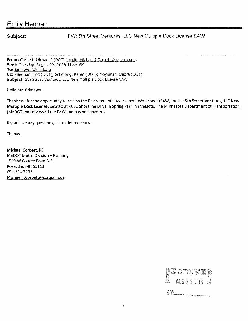
MnDOT Metro Division – Planning
Michael Corbett, PE, reviewed the EAW and had no concerns.
The LMCD has noted Mr. Corbett’s comments for the record.
MN DNR (Natural Heritage Review, Division of Ecological and Water Resources)
Ms. Lisa Joyal, Endangered Species Review Coordinator, acknowledged receipt of the
subject EAW and its query with the Minnesota Natural Heritage Information System
(NHIS). The NHIS query determines if any rare species or other significant natural
features are known to occur within an approximate one-mile radius of the proposed
project. It was found that pugnose shiners (Notropis anogenus), a state-listed threatened
fish species, and least darters (Etheostoma microperca), a state-listed fish species of
special concern, have been documented in Lake Minnetonka. The two species are
vulnerable to the removal of aquatic vegetation from lakes, increase in eutrophication
from nutrient enrichment, and increase in water turbidity or siltation that can be caused
from pollutions, pesticides, and runoff.
Ms. Joyal further stated that while the proposed project is unlikely to negatively affect
these species, actions to help improve the habitat conditions for these fish include the
following recommendations: minimize the use of pesticides and fertilizers, maintain or
restore lakeshore vegetation, minimize the removal of negative aquatic vegetation, and
maintain effective erosion and sediment control practices.
The NHIS is maintained by the Division of Ecological and Water Resources, Department
of Natural Resources and is continually updated as new information becomes available.
It is the most complete source of data on Minnesota’s rare or otherwise significant
species, native plant communities, and other natural features. However, the NHIS is not
an exhaustive inventory and thus does not represent all of the occurrences of rare features
within the state; acknowledging the possibility that ecologically significant features for
which they have no record may exist within the project area. To this end, if additional
information became available regarding rare features in the vicinity of the project, further
review may be necessary.

5th Street Ventures, LLC EAW Record of Decision (Findings of Fact, Conclusions, and LMCD Resolution 151) October 12, 2016 Page 2
For environmental review purposes, the results of their review, specific to the project
location and description provided, are valid for one year. The LMCD is to contact Ms.
Joyal should project details change or for an updated review if construction has not
occurred within one year.
The Natural Heritage Review does not constitute review or approval by the MNDNR as a
whole but only identifies issues regarding known occurrences of rare features and
potential effects of such. It was recommended that the LMCD contact the MN DNR
Regional Environmental Assessment Ecologist for the full review.
Contact information was offered for further review and comments.
The LMCD has noted the MN DNR Natural Heritage Review Division’s comments for
the record and has acknowledged the following:
Pugnose shiners (Notropis anogenus), a state-listed threatened fish species, and
least darters (Etheostoma microperca), a state-listed fish species of special
concern, have been documented in Lake Minnetonka. The two species are
vulnerable to the removal of aquatic vegetation from lakes, increase in
eutrophication from nutrient enrichment, and increase in water turbidity or
siltation that can be caused from pollutions, pesticides, and runoff.
If additional information becomes available regarding rare features in the vicinity
of the project, a further review may be necessary.
The LMCD should contact Ms. Joyal if project details change or if construction is
not completed within one year.
The LMCD did contact the MN DNR Regional Environmental Assessment
Ecologist whose comments are offered within.
MN DNR (Central Region, Division of Ecological and Water Resources)
Ms. Rebecca Horton, Regional Environmental Assessment Ecologist, acknowledged
review of the subject EAW. The following was noted: 1) the MN DNR Area Fisheries
Managers have set work exclusion dates in Public Waters in order to allow for fish
migration and spawning. For Seton Lake, the exclusion dates are April 1st to June 30
th
and 2) the MN DNR acknowledged there are no known rare species that will likely be
negatively affected by this project, Ms. Horton recommended the proposer recognize the
Natural Heritage review’s comments and act to improve habitat for the two state listed
species that are known to occur in the vicinity of the project; acknowledging
appreciation, in advance, for those efforts. Contact information was offered for further
questions or comments.
The LMCD has noted the MN DNR’s comments for the record and will notify the
proposer of the work exclusion dates of April 1st to June 30
th and their recommendation

5th Street Ventures, LLC EAW Record of Decision (Findings of Fact, Conclusions, and LMCD Resolution 151) October 12, 2016 Page 2
to address the actions outlined by the Heritage Review to improve habitat for the two
state listed species.
Minnesota Pollution Control Agency
Ms. Karen Kromar, Planner Principal, Environmental Review Unit, Resource
Management and Assistance Division, acknowledged receipt and review of the subject
EAW. Ms. Kromar further acknowledged that staff had no comments at this time.
Ms. Kromar requested a copy of the Record of Decision and stated that their
communication does not constitute approval by the Minnesota Pollution Control Agency
of any or all elements of the project for the purpose of pending or further permit action(s)
by the Agency. She further stated that it is the responsibility of the project proposer to
secure any required permits and to comply with any requisite permit conditions.
Contact information was offered for further review and comments.
The LMCD has noted the Minnesota Pollution Control Agency’s comments for the
record and will notify the proposer of their permitting responsibilities as noted above.
Metropolitan Council
Ms. Lisa Beth Barajas, Manager, Local Planning Assistance, acknowledged receipt of the
subject EAW. The Council staff reviewed the EAW’s accuracy, completeness, potential
impacts, and the need for an Environmental Impact Statement (EIS). Council found that
the proposed project was consistent with regional policies and an EIS was not needed for
regional purposes. Additional comments offered included:
The approved site plan identified the location of vegetated shoreline to the south
of the dock facility to be much closer in proximity to the dock than in the
proposed site plan. It was their understanding that the shoreline location is due to
that shoreline being part of the perimeter of a floating bog that exists within the
general area. Ms. Barajas documented that there was a high likelihood that the
bog could float off of its previously anchored position and migrate north towards
the channel and the newly proposed dock structures where it existed in the late
1950’s through the 1990’s.
That Hennepin County Environment and Energy staff, who maintains Seton
Channel open for navigational purposes, indicated that the bog tends to change in
size and location from year to year but has continued to maintain within the
channel for at least the last 60 years (confirmed by aerial photos).
Conditions of sufficient Lake level rise for the bog to become unanchored and
move during any particular summer season have increased during the last couple
of decades due to significant increases in the frequency of very heavy and
extreme precipitation events.

5th Street Ventures, LLC EAW Record of Decision (Findings of Fact, Conclusions, and LMCD Resolution 151) October 12, 2016 Page 2
It is their understanding that the anchoring of the bog is costly and limited to open
water season only.
It is their Council staff’s recommendation that a license for the dock facility
expansion only be granted if the commercial marina owner agrees to be
financially responsible for any facility damage resulting from “natural” bog
migration and the cost of moving/anchoring the bog during any future boating
season (with any necessary approvals) should it migrate into the dock facility.
The Council will take no formal action on the EAW and contact information was
provided.
The LMCD has noted Metropolitan Council’s comments for the record.
Conclusions
The LMCD has fulfilled all applicable procedural requirements of law and rule regarding the
determination of need for an Environmental Impact Statement (EIS) for the proposed
reconfiguration and reconstruction project at Howard’s Point Marina.
1. The proposed project has been evaluated by the public and the LMCD to determine
potential environmental effects. Based on the findings and record in this matter, the
LMCD has determined that the proposed project does not have the potential for
significant environmental effects. LMCD Resolution 151, which is attached to this
Record of Decision, was approved by the LMCD Board of Directors on October 12, 2016
declaring a negative need for an EIS.
2. A copy of this RGU Record of Decision is being provided, within five days, to all
persons on the EQB Distribution List, to persons commenting, and to persons who
requested a copy. This Record of Decision will also be available on the LMCD’s
website.
____________________________________________ ____________
Emily Herman , Administrative Assistant/Technician Date
To/Through Vickie Schleuning, Executive Director
Lake Minnetonka Conservation District
RGU Representative


Page 1 of 2
STATE OF MINNESOTA
LAKE MINNETONKA CONSERVATION DISTRICT
RESOLUTION 151
A RESOLUTION ORDERING A NEGATIVE DECLARATION ON THE NEED FOR AN
ENVIRONMENTAL IMPACT STATEMENT FOR 5th
STREET VENTURES, LLC
ENVIRONMENTAL ASSESSMENT WORKSHEET
WHEREAS, the Lake Minnetonka Conservation District (LMCD) is the Responsible
Governmental Unit (RGU) in the preparation of the Environmental Assessment Worksheet
(EAW) for proposed dock reconfiguration and reconstruction project at 5th
Street Ventures, LLC;
and
WHEREAS, the LMCD has submitted a copy of the EAW to all public agencies on the
EAW distribution list, publishing EAW availability in the EQB Monitor on August 22, 2016, all
of which were done in accordance with applicable State laws, rules, and regulations; and
WHEREAS, the 30-day comment period ended on September 21, 2016, with four public
agencies commenting (two Divisions within one); and
WHEREAS, the LMCD acknowledges the comments from MnDOT Metro Division
(Planning), Metropolitan Council, Minnesota Department of Natural Resources (MN DNR)
Central Region and Natural Heritage Review, and the Minnesota Pollution Control Agency; and
WHEREAS, the comments received do not support a need for an Environmental Impact
Statement (EIS) on the proposed project; and
WHEREAS, the LMCD has considered the comments that were received and shall
complete the Record of Decision supporting the declaration of negative need, including
responses to the commenting public agencies.
NOW, THEREFORE BE IT RESOLVED that the Board of Directors of the LMCD has
made a negative declaration on the need for an EIS for 5th
Street Ventures, LLC proposed dock
reconfiguration and reconstruction project.

Page 2 of 2
ADOPTED by the Board this 12th
day of October, 2016.
_____________________________
James Jay Green, Chair
ATTEST:
_______________________________
Gregory J. Thomas, Secretary

Page 1 of 2
DATE: October 14, 2016
TO: LMCD Member Cities
FROM: Vickie Schleuning, Executive Director
SUBJECT: Appointment of 2017 LMCD Board Members
The terms for some members of the Lake Minnetonka Conservation District (LMCD) Board of Directors will expire January 31, 2017. Terms on the LMCD Board run from February 1st through January 31st of the following year. The state enabling LMCD legislation calls for Board members to be appointed by their respective member cities for a three-year term, with no term limits. If necessary, a city does have the ability to recall its member anytime and appoint another member for the remainder of the three-year term. Some cities have made one-year appointments. Because of the uniqueness of Lake Minnetonka and the important application of the ordinances, it would be beneficial to have the Directors serve multiple years. As such, we hope that your current Director will consider serving another term. We appreciate their time and dedication to preserve and enhance the Lake Minnetonka experience.
At this time, the cities with the 2017 expiration terms are requested to reappoint or appoint new members to the Board of Directors. A list of the City appointment terms is provided in the table below.
2017- Appointments Requested 2018 2019 Deborah Zorn, Vice Chair- City of Shorewood
Jay Green, Chair- City of Mound Dennis Klohs, City of Minnetonka Beach
Gregg Thomas, Secretary- City of Tonka Bay Dan Baasen, City of Wayzata Sue Shuff, City of Minnetonka
Chris Jewett, Treasurer- City of Deephaven Gary Hughes, City of Spring Park
Ann Hoelscher, City of Victoria Gregg Prest, City of Excelsior
Gabriel Jabbour, City of Orono
Fred Meyer, City of Woodland
Brett Niccum, City of Minnetrista
Rob Roy, City of Greenwood
This past year, the overall attendance of the Board Members was good. The individual Board Member attendance records for the LMCD Regular meetings are provided below. Members may also have
ITEM 7D

Appointment of 2017 LMCD Board Members October 14, 2016
Page 2 of 2
attended Special Meetings, Workgroups, Committees, or events. The attendance records for Special Meetings are not included; fewer meetings were held due to the operational and format change for the second board meeting.
Member City Board Member
Number of
Meetings
Attended
Total
Meetings
Rate of
Attendance
(Percentage)
Deephaven Chris Jewett 12 20 60
Gregg Prest 6 8 75
Jennifer Caron 3 8 38
Jeff Morris 1 1 100
Greenwood Rob Roy 15 20 75
Minnetonka Sue Shuff 20 20 100
Minnetonka Beach Dennis Klohs 16 20 80
Minnetrista Bret Niccum 15 20 75
Mound Jay Green 20 20 100
Orono Gabriel Jabbour 20 20 100
Shorewood Deborah Zorn 17 20 85
Spring Park Gary Hughes 19 20 95
Tonka Bay Gregg Thomas 15 20 75
Victoria Ann Hoelscher 17 20 85
Wayzata Dan Baasen 16 20 80
Fred Meyer 11 12 92
James Doak 6 7 86
LMCD Member Attendance
Regular Board Meetings October 14, 2015 to September 28, 2016
Excelsior
Woodland Please let me know your city’s appointments for 2017 by December 31, 2016. Their appointment will start February 1, 2017. I look forward to working with your city in the coming year. If you have questions, please contact me at (952) 745-0789. Sincerely, Vickie Schleuning Executive Director
Web Page Address: http://www.lmcd.org E-mail Address: [email protected]
To protect and preserve Lake Minnetonka.
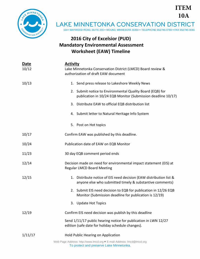
2016 City of Excelsior (PUD) Mandatory Environmental Assessment
Worksheet (EAW) Timeline
Date Activity 10/12 Lake Minnetonka Conservation District (LMCD) Board review &
authorization of draft EAW document
10/13 1. Send press release to Lakeshore Weekly News
2. Submit notice to Environmental Quality Board (EQB) forpublication in 10/24 EQB Monitor (Submission deadline 10/17)
3. Distribute EAW to official EQB distribution list
4. Submit letter to Natural Heritage Info System
5. Post on Hot topics
10/17 Confirm EAW was published by this deadline.
10/24 Publication date of EAW on EQB Monitor
11/23 30 day EQB comment period ends
12/14 Decision made on need for environmental impact statement (EIS) at Regular LMCD Board Meeting
12/15 1. Distribute notice of EIS need decision (EAW distribution list &anyone else who submitted timely & substantive comments)
2. Submit EIS need decision to EQB for publication in 12/26 EQBMonitor (Submission deadline for publication is 12/19)
3. Update Hot Topics
12/19 Confirm EIS need decision was publish by this deadline
Send 1/11/17 public hearing notice for publication in LWN 12/27 edition (safe date for holiday schedule changes).
1/11/17 Hold Public Hearing on Application
ITEM 10A
City of Excelsior (Multiple Dock PUD) EAW Page 1 of 15
July 2013 version (from EQB website)
ENVIRONMENTAL ASSESSMENT WORKSHEET This Environmental Assessment Worksheet (EAW) form and EAW Guidelines are available at
the Environmental Quality Board’s website at: The EQB webpage of Environmental Review
Guidance Documents / http://www.eqb.state.mn.us/EnvRevGuidanceDocuments.htm. The
EAW form provides information about a project that may have the potential for significant
environmental effects. The EAW Guidelines provide additional detail and resources for
completing the EAW form.
Cumulative potential effects can either be addressed under each applicable EAW Item, or can be
addresses collectively under EAW Item 19.
Note to reviewers: Comments must be submitted to the RGU during the 30-day comment period
following notice of the EAW in the EQB Monitor. Comments should address the accuracy and
completeness of information, potential impacts that warrant further investigation and the need for
an EIS.
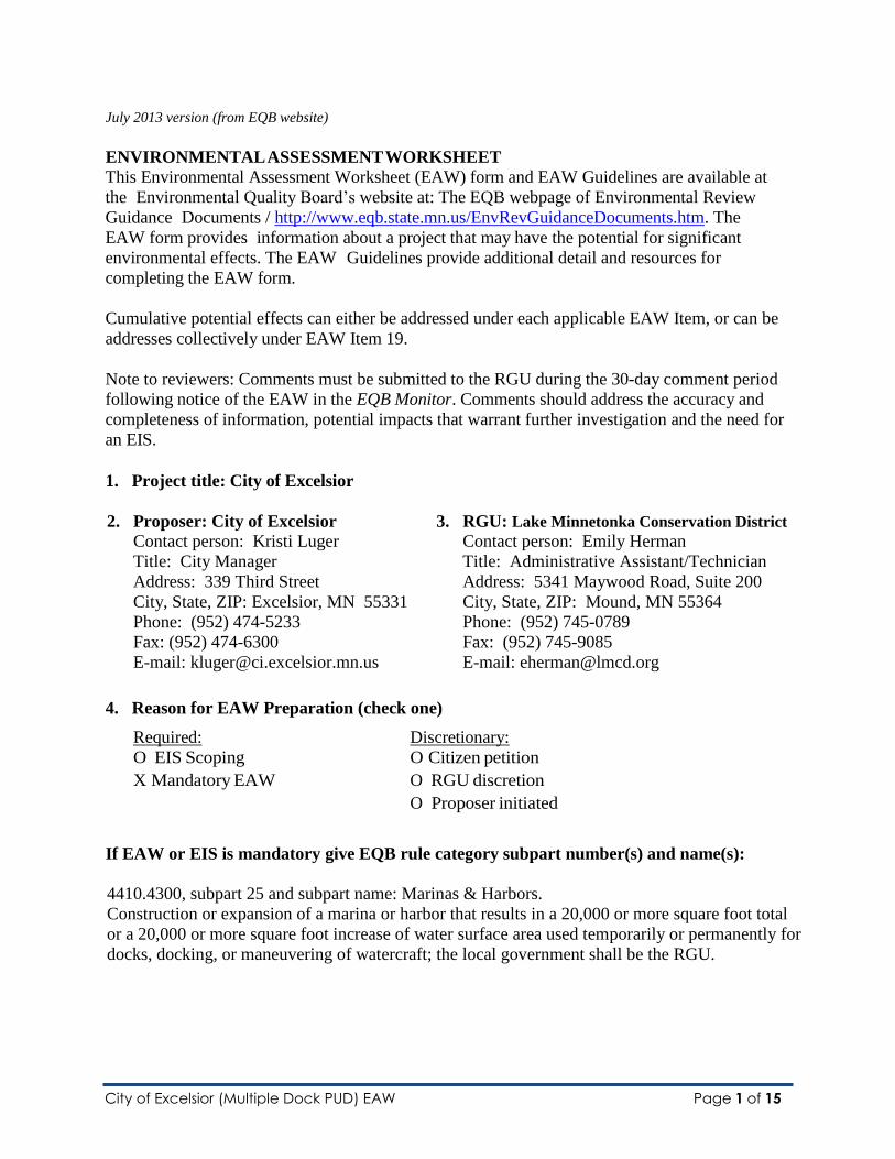
1. Project title: City of Excelsior
2. Proposer: City of Excelsior 3. RGU: Lake Minnetonka Conservation District
Contact person: Kristi Luger Contact person: Emily Herman
Title: City Manager Title: Administrative Assistant/Technician
Address: 339 Third Street Address: 5341 Maywood Road, Suite 200
City, State, ZIP: Excelsior, MN 55331 City, State, ZIP: Mound, MN 55364
Phone: (952) 474-5233 Phone: (952) 745-0789
Fax: (952) 474-6300 Fax: (952) 745-9085
E-mail: [email protected] E-mail: [email protected]
4. Reason for EAW Preparation (check one)
Required: Discretionary:
O EIS Scoping O Citizen petition
X Mandatory EAW O RGU discretion
O Proposer initiated
If EAW or EIS is mandatory give EQB rule category subpart number(s) and name(s):
4410.4300, subpart 25 and subpart name: Marinas & Harbors.
Construction or expansion of a marina or harbor that results in a 20,000 or more square foot total
or a 20,000 or more square foot increase of water surface area used temporarily or permanently for
docks, docking, or maneuvering of watercraft; the local government shall be the RGU.

City of Excelsior (Multiple Dock PUD) EAW Page 2 of 15
5. Project Location (two parcels) County: Hennepin
City/Township: Excelsior
Watershed (81 major watershed scale): Minnehaha Creek Watershed District
399 Lake Street, 55331
PLS Location: 204
Tax Parcel Number: 3411723110002
GPS Coordinates: N: Latitude 44.904625 , W: Longitude -93.565136
The Commons
PLS Location: Document #9980985. AUDITOR'S SUBDIVISION NO. 135 HENNEPIN
COUNTY, MINN - Block: NONE - Lot(s) 160; S34/T117/R23 - QQQ(s) NENE;
SHELDONS SUBDIVISIONS OF LOTS 56 TO 60 IN THE VILLAGE OF EXCELSIOR
AND OF LOTS 1 TO 5 AND 24 TO 27 AND 57 IN SNELLS ADDITION TO EXCELSIOR
& OF THE TRACT BETWEEN THESE LOTS AND LAKE MINNETONKA - Block: 3 -
Lot(s) 7, 8
Tax Parcel Number: None
GPS Coordinates: N: Latitude 44.906894, W: -93.566855
At a minimum attach each of the following to the EAW:
County map showing the general location of the project; U.S. Geological Survey 7.5 minute, 1:24,000 scale map indicating project
boundaries (photocopy acceptable); and
Site plans showing all significant project and natural features. Pre-construction site
plan and post- construction site plan.
6. Project Description
a. Provide the brief project summary to be published in the EQB Monitor, (approximately 50
words).
The Lake Minnetonka Conservation District (LMCD) is anticipating the receipt of a new
multiple dock municipal planned unit development (PUD) license application from the
City of Excelsior. The proposal would be to: 1) expand Piers 3, 4 and 5 within their
“Commons” area to just under 200’ out from the shore, 2) add additional watercraft
density, and 3) congregating transient watercraft storage to one specific area.
b. Give a complete description of the proposed project and related new construction,
including infrastructure needs. If the project is an expansion include a description of the
existing facility. Emphasize: 1) construction, operation methods and features that will
cause physical manipulation of the environment or will produce wastes, 2) modifications
City of Excelsior (Multiple Dock PUD) EAW Page 3 of 15
to existing equipment or industrial processes, 3) significant demolition, removal or
remodeling of existing structures, and 4) timing and duration of construction activities.
The City of Excelsior is proposing to submit a new multiple dock municipal planned unit
development (PUD) license application. The proposal would be to divide their single
multiple dock license into two separate licenses. The proposed project within this EAW
would provide for the multiple dock and PUD license expanding over 20,000 square feet
within the two parcels documented under #5 above. This project would provide for: 1) the
expansion of Piers 3, 4 and 5 within their “Commons” area to just under 200’ out from the
shore, 2) add an estimated 30 additional boat storage units (BSU) to those piers, and 3)
congregating transient watercraft storage to one specific area. Please see Approved and
Proposed site plans within.
Piers 3, 4 and 5 are the furthest dock structures to the west. Their BSU size will be
maintained at 22’ wide and 24’ long. Each pier is currently approved for the storage of 14
BSUs. The proposer would extend the three piers out to an estimated 180’; providing for
the remaining piers to remain at their original length.
The current license also provides for eight transient BSUs within Pier 1 (T-1 to T8) and an
additional six within the furthest east structure with the triangular tip. The proposal would
provide for Pier 1 to be designated to transient storage (proposed T1 to T14), as well as
remain with the original transient BSUs within the furthest east structure.
The City of Excelsior is currently approved for 128 BSU on 3,120 feet of 929.4’ of
shoreline. They are documented as legal, conforming site and maintain a watercraft
density of 1:24 through the issuance of a Special Density License.
The City of Excelsior maintains a separate District Mooring Area license issued by the
LMCD. This site is legal, non-conforming that is approved for the mooring of 12
watercraft that expand a maximum 225 out from the shoreline of the Commons area. This
licensed site has been in existence since the early 1970s and is not allowed to expand. Nor
does this site touch the shoreline of the “Commons” area. Staff has confirmed with a staff
member of the Environmental Quality Board that this licensed area is not required to be
tied to the EAW as it is a separately licensed site that is not expanding through the
proposed project.
LMCD Code of Ordinances provides for the issuance of a Municipal Planned Unit Development
Dock License with the ability to expand the dock structure and watercraft storage out to 200’
into the water subject maintaining: 1) at lease 200’ of continuous shoreline, 2) equal the amount
of shoreline left untouched with all structures and watercraft contained within one of the two
dock use areas (DUA).
The City of Excelsior is dedicating an estimated 2,000 feet of shoreline to the PUD. The lateral
extension of the dock structure is estimated at 680 feet; providing for more than double the
amount of shoreline dedicated as required to apply for a PUD license.
This mandatory EAW is directed exclusively to the proposed PUD licensed area on

City of Excelsior (Multiple Dock PUD) EAW Page 4 of 15
Excelsior Bay. It does not address:
Issues other than those associated with the water and the environment at or below
929.4 N.G.V.D. on the Lake, the ordinary high water mark established by the State
of Minnesota for Lake Minnetonka.
The proposed Site 2 license as described above.
The approved District Mooring Area.
Construction of the proposed expansion will consist of permanent machine-installed
pilings for structure support, with installation to occur in early 2017 through the ice. Noise
from the pile driving will occur during the construction of the proposed project.
Lake Minnetonka is a designated infested water containing Eurasian Watermilfoil, zebra
mussels, and flowering rush. Proper measures will be taken to mitigate spread by
thoroughly inspecting and cleaning all equipment prior to placement of any structure into
the water. The dock installer utilized for this project will maintain a Lake Service Provider
certification by the MN DNR.
LMCD records indicate that a mandatory EAW was performed in 1996 for the expansion
of the triangular pier directly to the east of the dedicated BSUs for the storage of charter
boats (see Approved site plan). This pier extension was added on to provide a safe area for
embarking and disembarking passengers for chartered excursions (also licensed by the
LCMD). Specifically, this addition provide for the operation of a licensed chartered steam
boat “Minnehaha.” This EAW received a negative declaration on the need for an
environmental Impact Statement for the City of Excelsior’s EAW. LMCD staff has chosen
to proceed with an EAW encompassing the square footage previously documented.
Water surface area occupied by the proposed docks, including dock structure and
maneuvering space, is 74,558 square feet. Further details of these calculations are
outlined in Attachment One.
c. Project magnitude:
Construction/ Infrastructure Elements Size
Total Project Acreage Linear project length Number and type of residential units Commercial building area (in square feet) Industrial building area (in square feet) Institutional building area (in square feet) Other uses – specify (in square feet) Structure height(s)
This Section deals with land construction information that is not related to docks placed in
the water. The project area is applicable to the extent of the water surface covered by the
dock structure and maneuvering space identified in Section 6b. Total project area of water
surface occupied by the proposed expansion project is 74,558 square feet.

City of Excelsior (Multiple Dock PUD) EAW Page 5 of 15
d. Explain the project purpose; if the project will be carried out by a governmental unit,
explain the need for the project and identify its beneficiaries.
The LMCD is a political subdivision of the State of Minnesota under Minnesota Statutes
Section 103B.605, Subdivision 1. One of the powers of the district is to regulate the
storage of watercraft and structures within the Lake. In doing so, the LMCD licenses site
that maintain five or more restricted watercraft (residential, municipal, marina, homeowner
association, etc.). To this end, the RGU requires a license from the City of Excelsior for
their proposed project. This project will provide greater access to the Lake for the public.
Piers 3, 4, and 5 would increase docking and watercraft storage availability to their local
residents and provide for four additional transient BSUs to the general Lake users.
e. Are future stages of this development including development on any other property
planned or likely to happen? If yes, briefly describe future stages, relationship to
present project, timeline and plans for environmental review.
X Yes No
Not specifically a future stage. However the RGU would point out that the licensee will
also be applying for a Special Density License. The City of Excelsior currently maintains
one; however, with the division of their currently approved license, each separate licensed
site will require a newly issued license.
The RGU’s general watercraft storage density regulation is one boat per 50 feet of
shoreline (1:50’). The Special Density License provides for sites that can demonstrate
instances where increased watercraft storage density may be clearly demonstrated to be a
benefit to the Lake and to the most general public use of the Lake. This process requires
the licensee to provide amenities (via a point scale) that are available to the public.
Amenity groups established for license consideration include Public Access,
Environmental Protection (over and above city and other governmental agencies minimum
requirements), and Public Service. If this license is approved by the RGU based on
meeting the required amenity points, the site may store up to one boat per 10 feet of
shoreline (1:10’).
The proposer will have an estimated 2,000 feet of shoreline established for this site.
Although 50% of the shoreline will remain free of structure and storage, the licensed site
could technically expand their density up to 200 vs. the proposed 144 for the PUD site.
The proposer would have the future ability to consider expanding within the proposed
licensed area or adjust the shoreline buffer mark. The maximum dock structure length
expansion is 200’. Either way, a new license would be required by the LMCD for Board
consideration.
f. Is this project a subsequent stage of an earlier project?
If yes, briefly describe the past development, timeline and any past environmental review.
Yes X No
City of Excelsior (Multiple Dock PUD) EAW Page 6 of 15
7. Cover types
Estimate the acreage of the site with each of the following cover types before and after
development:
Cover Type Before After Cover Type Before After
Wetlands Lawn/landscaping Deep water/streams Impervious surface Wooded/forest Stormwater Pond Brush/Grassland Other (describe) Cropland
TOTAL
This entire section is N/A.
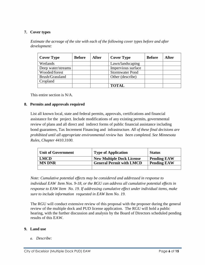
8. Permits and approvals required
List all known local, state and federal permits, approvals, certifications and financial
assistance for the project. Include modifications of any existing permits, governmental
review of plans and all direct and indirect forms of public financial assistance including
bond guarantees, Tax Increment Financing and infrastructure. All of these final decisions are
prohibited until all appropriate environmental review has been completed. See Minnesota
Rules, Chapter 4410.3100.
Unit of Government Type of Application Status
LMCD New Multiple Dock License Pending EAW MN DNR General Permit with LMCD Pending EAW
Note: Cumulative potential effects may be considered and addressed in response to
individual EAW Item Nos. 9-18, or the RGU can address all cumulative potential effects in
response to EAW Item No. 19. If addressing cumulative effect under individual items, make
sure to include information requested in EAW Item No. 19.
The RGU will conduct extensive review of this proposal with the proposer during the general
review of the multiple dock and PUD license application. The RGU will hold a public
hearing, with the further discussion and analysis by the Board of Directors scheduled pending
results of this EAW.
9. Land use
a. Describe:

City of Excelsior (Multiple Dock PUD) EAW Page 7 of 15
i. Existing land use of the site as well as areas adjacent to and near the site,
including parks, trails, prime or unique farmlands.
Two parcels will be associated with this proposed project (as listed above). 399 Lake
Street is vacant lakeshore. The “Commons” does not have platted results; however, it
is owned by the residents of the City of Excelsior and under the operation of the City of
Excelsior. In quoting the city’s website, “The Excelsior Commons and Port of
Excelsior are historic, dating to the origins of the city, and are widely recognized as
Excelsior’s chief assets. The 13-acre park includes open recreation areas, picnic sites,
playgrounds, two swimming beaches, tennis courts, baseball fields, a band shell,
bathhouse, public restrooms, docks, buoys, and docking for public excursion boats that
provide lake access for those who do not own personal boats.
In addition to traditional park uses such as picnics and family gatherings, the Excelsior
Commons and Port of Excelsior serve diverse recreational opportunities for all age
groups with the annual Art Fair, Fourth of July celebration, organized sports, and other
large events.”
Residential living and commercial enterprises are blocks away from both noted parcels,
except condominiums otherwise referenced within the document.
ii. Plans: describe planned land use as identified in comprehensive plan (if available)
and any other applicable plan for land use, water, or resources management by a
local, regional, state, or federal agency.
Dock structures on Lake Minnetonka are subject to a water resources management plan
of the RGU, namely its "Management Plan for Lake Minnetonka;" dock structure
ordinances, and boat density policies. Expansion of the proposed project is feasible as
described under 6e above.
iii. Zoning, including special districts or overlays such as shoreland, floodplain, wild
and scenic rivers, critical area, agricultural preserves, etc.
This section is N/A.
b. Discuss the project’s compatibility with nearby land uses, zoning, and plans listed in
Item 9a above, concentrating on implications for environmental effects.
The LMCD defines the dock use area (DUA) of all sites maintaining 929.4 feet of
lakeshore. This process provides for defined setbacks and dock length restrictions
for the storage of all structures. Whether the nearby land uses are zoned commercial
or residential, they are subject to the defined regulations as outlined in Chapter 2 of
the LMCD Code of Ordinances; specifically sections 2.01 and 2.02.
Excelsior Bay consists of multiple licensed sites by the RGU (two Lake accessed

City of Excelsior (Multiple Dock PUD) EAW Page 8 of 15
restaurants that provide transient watercraft storage, two marinas, condominiums,
and residential living. The proposed use is consistent with the current use with
expansion of the docks adjacent to the park use area.
Identify measures incorporated into the proposed project to mitigate any potential
incompatibility as discussed in Item 9b above.
The City of Excelsior has maintained a multiple dock and district mooring area license
since the late 1970’s. The PUD ordinance provides municipalities the ability to
extend their dock structure and watercraft storage out further into the Lake (a cluster
effect) in an effort to leave shoreline in its natural state. Per current LMCD Code,
the proposer would also have the ability to continue to expand along the shoreline.
The proposer has chosen not to expand to maximum density at this time.
10. Geology, soils and topography/land forms
a. Geology - Describe the geology underlying the project area and identify and map any
susceptible geologic features such as sinkholes, shallow limestone formations,
unconfined/shallow aquifers, or karsts conditions. Discuss any limitations of these
features for the project and any effects the project could have on these features. Identify
any project designs or mitigation measures to address effects to geologic features.
b. Soils and topography - Describe the soils on the site, giving NRCS (SCS) classifications
and descriptions, including limitations of soils. Describe topography, any special site
conditions relating to erosion potential, soil stability or other soils limitations, such as
steep slopes, highly permeable soils. Provide estimated volume and acreage of soil
excavation and/or grading. Discuss impacts from project activities (distinguish between
construction and operational activities) related to soils and topography. Identify
measures during and after project construction to address soil limitations including
stabilization, soil corrections or other measures. Erosion/sedimentation control related
to stormwater runoff should be addressed in response to Item 11.b.ii.
NOTE: For silica sand projects, the EAW must include a hydro geologic investigation assessing
the potential groundwater and surface water effects and geologic conditions that could create
an increased risk of potentially significant effects on groundwater and surface water.
Descriptions of water resources and potential effects from the project in EAW Item 11 must be
consistent with the geology, soils and topography/land forms and potential effects described in
EAW Item 10.
This entire section is N/A.

City of Excelsior (Multiple Dock PUD) EAW Page 9 of 15
11. Water resources
a. Describe surface water and groundwater features on or near the site in a.i. and a.ii. below:
i. Surface water – lakes, streams, wetlands, intermittent channels, and county/judicial
ditches. Include any special designations such as public waters, trout stream/lake,
wildlife lakes, migratory waterfowl feeding/resting lake, and outstanding resource
value water. Include water quality impairments or special designations listed on the
current MPCA 303d Impaired Waters List that are within 1 mile of the project.
Include DNR Public Waters Inventory number(s), if any.
The project is in Excelsior Bay, part of Lake Minnetonka (27013300).
ii. Groundwater – aquifers, springs, seeps. Include: 1) depth to groundwater; 2) if
project is within a MDH wellhead protection area; 3) identification of any onsite
and/or nearby wells, including unique numbers and well logs if available. If there
are no wells known on site or nearby, explain the methodology used to determine
this.
This section is N/A.
b. Describe effects from project activities on water resources and measures to minimize or
mitigate the effects in Item b.i. through Item b.iv. below.
i. Wastewater - For each of the following, describe the sources, quantities and
composition of all sanitary, municipal/domestic and industrial wastewater
produced or treated at the site.
(1) If the wastewater discharge is to a publicly owned treatment facility, identify any
pretreatment measures and the ability of the facility to handle the added water
and waste loadings, including any effects on, or required expansion of,
municipal wastewater infrastructure.
(2) If the wastewater discharge is to a subsurface sewage treatment systems (SSTS),
describe the system used, the design flow, and suitability of site conditions for
such a system.
(3) If the wastewater discharge is to surface water, identify the wastewater
treatment methods and identify discharge points and proposed effluent
limitations to mitigate impacts. Discuss any effects to surface or
groundwater from wastewater discharges.

City of Excelsior (Multiple Dock PUD) EAW Page 10 of 15
This section is N/A.
ii. Stormwater – Describe the quantity and quality of stormwater runoff at the site prior
to and post construction. Include the routes and receiving water bodies for runoff
from the site (major downstream water bodies as well as the immediate receiving
waters). Discuss any environmental effects from stormwater discharges. Describe
stormwater pollution prevention plans including temporary and permanent runoff
controls and potential BMP site locations to manage or treat stormwater runoff.
Identify specific erosion control, sedimentation control or stabilization measures to
address soil limitations during and after project construction.
This section is N/A.
iii. Water appropriation - Describe if the project proposes to appropriate surface or
groundwater (including dewatering). Describe the source, quantity, duration, use
and purpose of the water use and if a DNR water appropriation permit is required.
Describe any well abandonment. If connecting to an existing municipal water
supply, identify the wells to be used as a water source and any effects on, or
required expansion of, municipal water infrastructure. Discuss environmental
effects from water appropriation, including an assessment of the water resources
available for appropriation. Identify any measures to avoid, minimize, or mitigate
environmental effects from the water appropriation.
This section is N/A.
iv. Surface Waters
(1) Wetlands - Describe any anticipated physical effects or alterations to wetland
features such as draining, filling, permanent inundation, dredging and vegetative
removal. Discuss direct and indirect environmental effects from physical
modification of wetlands, including the anticipated effects that any proposed
wetland alterations may have to the host watershed. Identify measures to avoid
(e.g., available alternatives that were considered), minimize, or mitigate
environmental effects to wetlands. Discuss whether any required compensatory
wetland mitigation for unavoidable wetland impacts will occur in the same minor
or major watershed, and identify those probable locations.
(2) Other surface waters- Describe any anticipated physical effects or alterations to
surface water features (lakes, streams, ponds, intermittent channels,
county/judicial ditches) such as draining, filling, permanent inundation,
dredging, diking, stream diversion, impoundment, aquatic plant removal and

City of Excelsior (Multiple Dock PUD) EAW Page 11 of 15
riparian alteration. Discuss direct and indirect environmental effects from
physical modification of water features. Identify measures to avoid, minimize, or
mitigate environmental effects to surface water features, including in- water Best
Management Practices that are proposed to avoid or minimize
turbidity/sedimentation while physically altering the water features. Discuss how
the project will change the number or type of watercraft on any water body,
including current and projected watercraft usage.
The proposed plan includes expansion of boat storage units within LMCD code
requirements. It is not anticipated all watercraft would be operated simultaneously
on the lake.
12. Contamination/Hazardous Materials/Wastes
a. Pre-project site conditions - Describe existing contamination or potential environmental
hazards on or in close proximity to the project site such as soil or ground water
contamination, abandoned dumps, closed landfills, existing or abandoned storage tanks,
and hazardous liquid or gas pipelines. Discuss any potential environmental effects from
pre-project site conditions that would be caused or exacerbated by project construction
and operation. Identify measures to avoid, minimize or mitigate adverse effects from
existing contamination or potential environmental hazards. Include development of a
Contingency Plan or Response Action Plan.
b. Project related generation/storage of solid wastes - Describe solid wastes
generated/stored during construction and/or operation of the project. Indicate method
of disposal. Discuss potential environmental effects from solid waste handling, storage
and disposal. Identify measures to avoid, minimize or mitigate adverse effects from the
generation/storage of solid waste including source reduction and recycling.
c. Project related use/storage of hazardous materials - Describe chemicals/hazardous
materials used/stored during construction and/or operation of the project including
method of storage. Indicate the number, location and size of any above or below
ground tanks to store petroleum or other materials. Discuss potential environmental
effects from accidental spill or release of hazardous materials. Identify measures to
avoid, minimize or mitigate adverse effects from the use/storage of
chemicals/hazardous materials including source reduction and recycling. Include
development of a spill prevention plan.
d. Project related generation/storage of hazardous wastes - Describe hazardous wastes
generated/stored during construction and/or operation of the project. Indicate method of
disposal. Discuss potential environmental effects from hazardous waste handling,
storage, and disposal. Identify measures to avoid, minimize or mitigate adverse effects

City of Excelsior (Multiple Dock PUD) EAW Page 12 of 15
from the generation/storage of hazardous waste including source reduction and
recycling.
This entire section is N/A.
13. Fish, wildlife, plant communities, and sensitive ecological resources (rare features)
a. Describe fish and wildlife resources as well as habitats and vegetation on or in near the
site.
b. Describe rare features such as state-listed (endangered, threatened or special concern)
species, native plant communities, Minnesota County Biological Survey Sites of
Biodiversity Significance, and other sensitive ecological resources on or within close
proximity to the site. Provide the license agreement number (LA) and/or
correspondence number (ERDB) from which the data were obtained and attach the
Natural Heritage letter from the DNR. Indicate if any additional habitat or species
survey work has been conducted within the site and describe the results.
c. Discuss how the identified fish, wildlife, plant communities, rare features and ecosystems
may be affected by the project. Include a discussion on introduction and spread of
invasive species from the project construction and operation. Separately discuss effects
to known threatened and endangered species.
d. Identify measures that will be taken to avoid, minimize, or mitigate adverse effects
to fish, wildlife, plant communities, and sensitive ecological resources.
Fish, wildlife, and habitats on or near the site are consistent with other areas of Lake
Minnetonka. Therefore, staff believes the proposed project would have little to no impact.
The area where the new docks and slips will be installed is where the existing structures
have been in existence for many years; providing for three piers extending an additional 95
feet out into the Lake.
As part of this process, the preparer will notify a number of regulating agencies, including
a Natural Heritage review.
14. Historic properties
Describe any historic structures, archeological sites, and/or traditional cultural properties
on or in close proximity to the site. Include: 1) historic designations, 2) known artifact
areas, and 3) architectural features. Attach letter received from the State Historic
Preservation Office (SHPO). Discuss any anticipated effects to historic properties during
project construction and operation. Identify measures that will be taken to avoid, minimize,
or mitigate adverse effects to historic properties.

City of Excelsior (Multiple Dock PUD) EAW Page 13 of 15
The RGU, through distribution of this EAW, will confirm there are no properties listed in
the Register of Historic Places and no known archaeological properties in the area that will
be affected by this project.
15. Visual
Describe any scenic views or vistas on or near the project site. Describe any project related
visual effects such as vapor plumes or glare from intense lights. Discuss the potential visual
effects from the project. Identify any measures to avoid, minimize, or mitigate visual effects.
Lights may be visible from dock lighting. The extent of the light which may be used on a
licensed multiple dock facility is a matter for control by the RGU.
16. Air
a. Stationary source emissions - Describe the type, sources, quantities and compositions of
any emissions from stationary sources such as boilers or exhaust stacks. Include any
hazardous air pollutants, criteria pollutants, and any greenhouse gases. Discuss effects
to air quality including any sensitive receptors, human health or applicable regulatory
criteria. Include a discussion of any methods used assess the project’s effect on air
quality and the results of that assessment. Identify pollution control equipment and other
measures that will be taken to avoid, minimize, or mitigate adverse effects from
stationary source emissions.
This section is N/A.
b. Vehicle emissions – Describe the effect of the project’s traffic generation on air
emissions. Discuss the project’s vehicle-related emissions effect on air quality. Identify
measures (e.g. traffic operational improvements, diesel idling minimization plan) that
will be taken to minimize or mitigate vehicle-related emissions.
This section is N/A.
c. Dust and odors – Describe sources, characteristics, duration, quantities, and intensity of
dust and odors generated during project construction and operation. (Fugitive dust may
be discussed under item 16a). Discuss the effect of dust and odors in the vicinity of the
project including nearby sensitive receptors and quality of life. Identify measures that will
be taken to minimize or mitigate the effects of dust and odors.
This section is N/A.
17. Noise

City of Excelsior (Multiple Dock PUD) EAW Page 14 of 15
Describe sources, characteristics, duration, quantities, and intensity of noise generated
during project construction and operation. Discuss the effect of noise in the vicinity of the
project including 1) existing noise levels/sources in the area, 2) nearby sensitive receptors,
3) conformance to state noise standards, and 4) quality of life. Identify measures that will
be taken to minimize or mitigate the effects of noise.
Noise may be generated during the installation of the dock structures. Based on the
proposal, minimal to no greater noise levels are anticipated to be generated during the
normal operation of the marina.
18. Transportation
a. Describe traffic-related aspects of project construction and operation. Include: 1)
existing and proposed additional parking spaces, 2) estimated total average daily traffic
generated, 3) estimated maximum peak hour traffic generated and time of occurrence, 4)
indicate source of trip generation rates used in the estimates, and 5) availability of
transit and/or other alternative transportation modes.
b. Discuss the effect on traffic congestion on affected roads and describe any traffic
improvements necessary. The analysis must discuss the project’s impact on the regional
transportation system. If the peak hour traffic generated exceeds 250 vehicles or the total
daily trips exceeds 2,500, a traffic impact study must be prepared as part of the EAW.
Use the format and procedures described in the Minnesota Department of
Transportation’s Access Management Manual, Chapter 5 (available at: Minnesota
Department of Transportation Access Management Resources
/http://www.dot.state.mn.us/accessmanagement/resources.html) or a similar local guidance.
c. Identify measures that will be taken to minimize or mitigate project related transportation
effects.
The proposed project will be constructed within the waters of Lake Minnetonka. The
expanded structures are the furthest piers along the northern edge of the shoreline with
access to the bay. The addition of four transient BSU does not appear to be a significant
change for the areas’ use.
19. Cumulative potential effects
Note: Preparers can leave this item blank if cumulative potential effects are addressed
under the applicable EAW Items.
All necessary cumulative potential effects analysis information has been presented
item-by-item.

City of Excelsior (Multiple Dock PUD) EAW Page 15 of 15
a. Describe the geographic scales and timeframes of the project related environmental
effects that could combine with other environmental effects resulting in cumulative
potential effects.
b. Describe any reasonably foreseeable future projects (for which a basis of expectation
has been laid) that may interact with environmental effects of the proposed project
within the geographic scales and timeframes identified above.
c. Discuss the nature of the cumulative potential effects and summarize any other
available information relevant to determining whether there is potential for
significant environmental effects due to these cumulative effects.
20. Other potential environmental effects
If the project may cause any additional environmental effects not addressed by items 1 to 19,
describe the effects here, discuss the how the environment will be affected, and identify
measures that will be taken to minimize and mitigate these effects.
The RGU does not believe any additional environmental effects will be affected by the
proposed project.
RGU CERTIFICATION
The Environmental Quality Board will only accept SIGNED Environmental Assessment
Worksheets for public notice in the EQB Monitor.
I hereby certify that:
The information contained in this document is accurate and complete to the best of my
knowledge.
The EAW describes the complete project; there are no other projects, stages or
components other than those described in this document, which are related to the project
as connected actions or phased actions, as defined at Minnesota Rules, parts 4410.0200,
subparts 9c and 60, respectively.
Copies of this EAW are being sent to the entire EQB distribution list.
Signature: ___________________________________________ October 13, 2016
Emily Herman, Administrative Assistant/Technician Date
To/Through Vickie Schleuning, Executive Director
Lake Minnetonka Conservation District
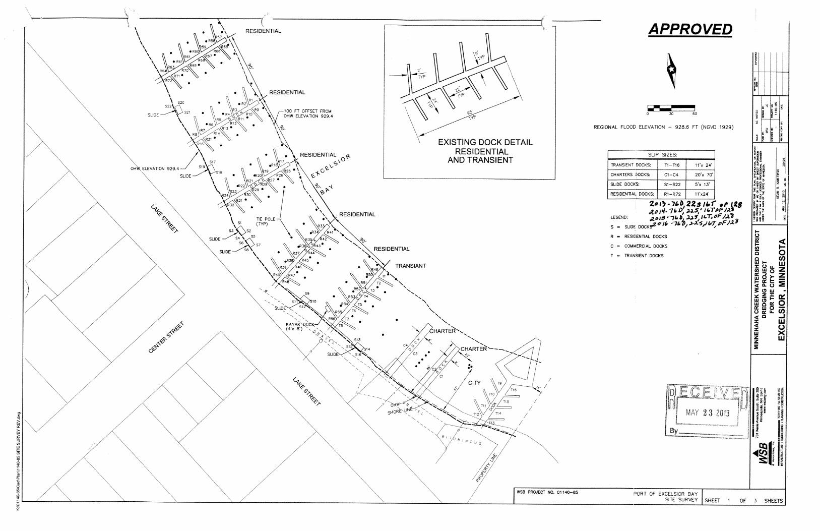
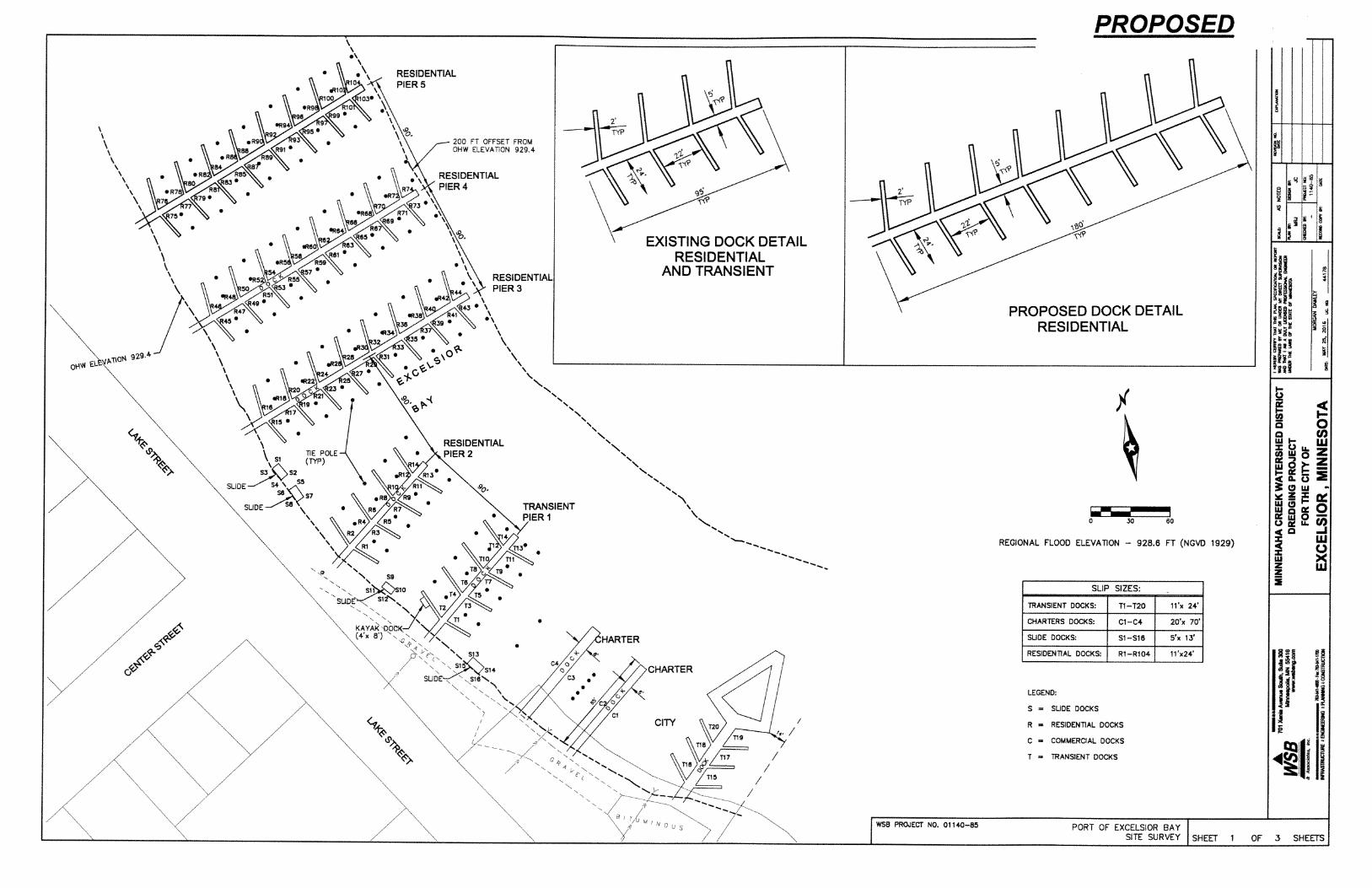
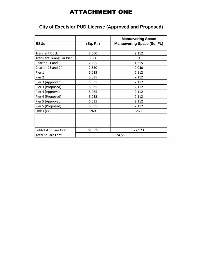
ATTACHMENT ONE
Manuevering Space
BSUs (Sq. Ft.) Manuevering Space (Sq. Ft.)
Transient Dock 2,650 2,112
Transient Triangular Pier 3,600 0
Charter C1 and C2 2,295 1,615
Charter C3 and C4 2,550 2,040
Pier 1 5,035 2,112
Pier 2 5,035 2,112
Pier 3 (Approved) 5,035 2,112
Pier 3 (Proposed) 5,035 2,112
Pier 4 (Approved) 5,035 2,112
Pier 4 (Proposed) 5,035 2,112
Pier 5 (Approved) 5,035 2,112
Pier 5 (Proposed) 5,035 2,112
Slides (x4) 260 260
Subtotal Square Feet 51,635 22,923
Total Square Feet
City of Excelsior PUD License (Approved and Proposed)
74,558
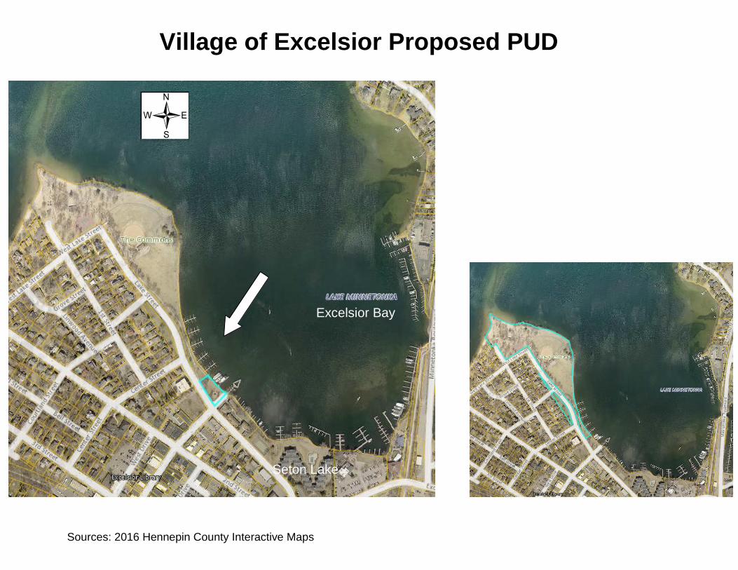
Village of Excelsior Proposed PUD
Sources: 2016 Hennepin County Interactive Maps
/
Excelsior Bay
West Arm Bay
Seton Lake

Web Page Address: http://www.lmcd.org E-mail Address: [email protected]
To protect and preserve Lake Minnetonka.
2016 Browns Bay Marina (Site 2) Mandatory Environmental Assessment
Worksheet (EAW) Timeline
Date Activity 10/12 Lake Minnetonka Conservation District (LMCD) Board review &
authorization of draft EAW document
10/13 1. Send press release to Lakeshore Weekly News
2. Submit notice to Environmental Quality Board (EQB) forpublication in 10/24 EQB Monitor (Submission deadline 10/17)
3. Distribute EAW to official EQB distribution list
4. Submit letter to Natural Heritage Info System
5. Post on Hot topics
10/17 Confirm EAW was published by this deadline.
10/24 Publication date of EAW on EQB Monitor
11/23 30 day EQB comment period ends
12/14 Decision made on need for environmental impact statement (EIS) at Regular LMCD Board Meeting
12/15 1. Distribute notice of EIS need decision (EAW distribution list &anyone else who submitted timely & substantive comments)
2. Submit EIS need decision to EQB for publication in 12/26 EQBMonitor (Submission deadline for publication is 12/19)
3. Update Hot Topics
12/19 Confirm EIS need decision was publish by this deadline
Send 1/11/17 public hearing notice for publication in LWN 12/27 edition (safe date for holiday schedule changes).
1/11/17 Hold Public Hearing on Application
ITEM 10A
Browns Bay Marina (Site 2) EAW Page 1 of 15
EQB July 2013 EAW Version
ENVIRONMENTAL ASSESSMENT WORKSHEET This Environmental Assessment Worksheet (EAW) form and EAW Guidelines are available at
the Environmental Quality Board’s website at: The EQB webpage of Environmental Review
Guidance Documents / http://www.eqb.state.mn.us/EnvRevGuidanceDocuments.htm. The
EAW form provides information about a project that may have the potential for significant
environmental effects. The EAW Guidelines provide additional detail and resources for
completing the EAW form.
Cumulative potential effects can either be addressed under each applicable EAW Item, or can be
addressed collectively under EAW Item 19.
Note to reviewers: Comments must be submitted to the RGU during the 30-day comment period
following notice of the EAW in the EQB Monitor. Comments should address the accuracy and
completeness of information, potential impacts that warrant further investigation and the need for
an EIS.
1. Project title: Browns Bay Marina (Site 2)
2. Proposer: Browns Bay Marina (Site 2) 3. RGU: Lake Minnetonka Conservation District
Contact person: Luke Kujawa Contact person: Emily Herman
Title: Co-Owner Title: Administrative Assistant/Technician
Address: 1444 Shoreline Drive Address: 5341 Maywood Road, Suite 200
City, State, ZIP: Orono, MN 55391 City, State, ZIP: Mound, MN 55364
Phone: (612) 208-1800 Phone: (952) 745-0789
Fax: (612)-208-1779 Fax: (952) 745-9085
E-mail: [email protected] E-mail: [email protected]
4. Reason for EAW Preparation (check one)
Required: Discretionary:
O EIS Scoping O Citizen petition
X Mandatory EAW O RGU discretion
O Proposer initiated
If EAW or EIS is mandatory give EQB rule category subpart number(s) and name(s):
4410.4300, subpart 25 and subpart name: Marinas & Harbors.
Construction or expansion of a marina or harbor that results in a 20,000 or more square foot total
or a 20,000 or more square foot increase of water surface area used temporarily or permanently for
docks, docking, or maneuvering of watercraft; the local government shall be the RGU.

Browns Bay Marina (Site 2) EAW Page 2 of 15
5. Project Location (three parcels) County: Hennepin
City/Township: Orono
PLS Location (That Part of Govt. Lot 1, Section 11, Township 117, and Range 23)
Watershed (81 major watershed scale): Minnehaha Creek Watershed District
1444 Shoreline Drive; Parcel with Structure
Tax Parcel Number: 11-117-23-22-0017
GPS Coordinates: N: Latitude 44.961401, W: Longitude -93.558784
1442 Shoreline Drive; Parcel with Dedicated Shoreline Only
Tax Parcel Number 11-117-23-22-0005
GPS Coordinates: N: Latitude 44.961928, W: Longitude -93.558429
1440 Shoreline Drive; Parcel with Dedicated Shoreline Only
Tax Parcel Number 11-117-23-22-0004
GPS Coordinates: N: Latitude 44.962022, W: Longitude -93.558484
At a minimum attach each of the following to the EAW:
County map showing the general location of the project; U.S. Geological Survey 7.5 minute, 1:24,000 scale map indicating project boundaries
(photocopy acceptable); and
Site plans showing all significant project and natural features. Pre-construction site plan
and post- construction site plan.
6. Project Description
a. Provide the brief project summary to be published in the EQB Monitor, (approximately 50
words).
The Lake Minnetonka Conservation District (LMCD) is anticipating the receipt of a new
multiple dock license application from Browns Bay Marina (Site 2), located at 1444
Shoreline Drive in Orono, MN 55391. The proposal is to reconfigure the existing non-
permanent dock structures utilizing conforming side setbacks and length dimensions;
resulting in the repeal of a currently approved variance for both the north and south
extended property lines.
The currently approved variance provides for a zero foot setback to the south and the
allowance of three dock fingers to extend over two differently zoned properties. Chapter 2,
Section 2.03, Subd. 9, “Dock Extensions” does not allow a multiple dock or mooring area
or commercial dock to extend across the extended zone line between sites zoned
differently by a municipality. The north extension was allowed based on the proposer
reducing the available dock use area of the subject site by approximately 50% and within
Browns Bay Marina (Site 2) EAW Page 3 of 15
the spirit and intent of the LMCD Code of Ordinances.
This site maintains dock structures and watercraft storage at 1444 Shoreline Drive;
however, the shoreline measurements for 1442 and 1440 Shoreline Drive are also
dedicated to the density offered at 1444 Shoreline Drive.
Proposed site plan is subject to minor changes once the exact dock structure material is
chosen. This could include the reinsertion of some currently approved corner pedestals for
lighting (currently 24 at 2.8' for a total of 67.2') and the widening of the dock structure
based on materials used or installation of pumpers (estimated one foot).
b. Give a complete description of the proposed project and related new construction,
including infrastructure needs. If the project is an expansion include a description of the
existing facility. Emphasize: 1) construction, operation methods and features that will
cause physical manipulation of the environment or will produce wastes, 2) modifications
to existing equipment or industrial processes, 3) significant demolition, removal or
remodeling of existing structures, and 4) timing and duration of construction activities.
Browns Bay Marina (Site 2) has proposed to reconfigure its multiple dock facility on
Tanager Bay. Currently, the facility is approved for 40 Boat Storage Units (BSUs) on
approximately 240 feet of continuous shoreline (via the three listed tax parcels noted
above). The site has a BSU density of one for each six feet of continuous shoreline.
The applicant is proposing to submit a new multiple dock license application for the
reconfiguration of the dock structure utilizing LMCD Code Section 2.03, Multiple Docks,
Mooring Areas, Commercial Docks, and Launching Ramps and incorporating Ordinance
217 for Qualified Commercial Marinas.
The proposed project would not increase the number of BSUs. The applicant is proposing
to reconfigure and reconstruct all dock structures within the facility (see Approved and
Proposed Site Plans). Conforming side setbacks would be met on both the northerly and
southerly extended property lines. In utilizing Ordinance 217, the dock structures will be
extended to 200 feet out from the 929.4’ ordinary high water level; maintaining a
conforming length. Currently the site has an approved variance (see 6a). The proposed
reconfiguration would allow this variance to be repealed upon approval of the LMCD
Board of Directors.
A "Qualified Commercial Marina" is a privately owned, revenue producing business that rents
storage for 13 or more watercraft on Lake Minnetonka. A facility does not qualify as a
"Qualified Commercial Marina" unless all rented BSUs on the Lake are freely available to the
public without requiring membership in any organization and without providing any priority or
preferences to members of any organization.
Additional BSUs may be used for purposes other than rental to the general public, subject to
the following limitations:
No more than 20% of all BSUs may be used for any combination of the following uses
(watercraft held for sale by the marina owner, watercraft being repaired by the marina
Browns Bay Marina (Site 2) EAW Page 4 of 15
owner, rental watercraft, emergency storage of a disabled watercraft for up to three
business days, or BSUs made available under a priority or preference to owners of
specified real property under real estate interests created prior to 1995).
No more than the number of BSUs rented to the general public may be used for any
combination of the following uses (transient use, storage of commercial or government
lake maintenance watercraft, or storage of governmental watercraft for emergency
response or law enforcement uses).
This mandatory EAW is directed exclusively to the multiple dock facility on Tanager Bay.
It does not address:
Issues other than those associated with the water and the environment at or below
929.4 N.G.V.D. on the Lake, the ordinary high water mark established by the State
of Minnesota for Lake Minnetonka.
A second marina owned by Browns Bay Marina directly to the east, licensed
separately by the LMCD as Browns Bay Marina (Site 1).
Construction of the proposed expansion project will consist of seasonal dock structures
(designed and constructed to be removed from the Lake on a seasonal basis with all
components capable of removal by manual means without use of power equipment,
machines or tools other than hand held power tools). The applicant does have the ability to
leave the dock structures in place over the winter. Installation is planned for operation by
the 2017 boating season subject to Board approval.
Lake Minnetonka is a designated infested water containing Eurasian Watermilfoil, zebra
mussels, and flowering rush. Proper measures will be taken to mitigate spread by
thoroughly inspecting and cleaning all equipment prior to placement of any structure into
the water. The proposer is MN DNR certified as a Lake Service Provided. Whether the
proposer or a hired contractor installs the dock structures, staff has been assured it will be
performed by a MN DNR certified Lake Service Providers.
LMCD records indicate that a mandatory EAW has not been previously prepared for this
multiple dock facility. Water surface area occupied by the proposed docks, including dock
structure and maneuvering space, is 25,618 square feet. Further details of these
calculations are outlined in Attachment One.
c. Project magnitude:
Construction/ Infrastructure Elements Size
Total Project Acreage Linear project length Number and type of residential units Commercial building area (in square feet) Industrial building area (in square feet) Institutional building area (in square feet) Other uses – specify (in square feet) Structure height(s)

Browns Bay Marina (Site 2) EAW Page 5 of 15
This Section deals with land construction information that is not related to docks placed in
the water. The project area is applicable to the extent of the water surface covered by the
dock structure and maneuvering space identified in Section 6b. Total project area of water
surface occupied by the proposed expansion project is 25,618 square feet.
d. Explain the project purpose; if the project will be carried out by a governmental unit,
explain the need for the project and identify its beneficiaries.
The LMCD is a political subdivision of the State of Minnesota under Minnesota Statutes
Section 103B.605, Subdivision 1. One of the powers of the district is to regulate the
storage of watercraft and structures within the Lake. In doing so, the LMCD licenses sites
(residential, municipal, marina, homeowner association, etc.) that maintain five or more
restricted watercraft. To this end, the RGU requires a license from the proposer for the
expanded project. The proposed project will continue to offer public access to the Lake
while recommending the repeal of the currently approved variance in conforming to the
LMCD Code of Ordinances.
e. Are future stages of this development including development on any other property
planned or likely to happen?
O Yes X No
If yes, briefly describe future stages, relationship to present project, timeline and plans
for environmental review.
f. Is this project a subsequent stage of an earlier project?
If yes, briefly describe the past development, timeline and any past environmental review.
X Yes O No
Not specifically a subsequent stage but more an ending to original goals. Prior to 2007, this
site was purchased by the proposer. Since that date, the proposer has rectified a dock
structure that was not in compliance with an originally the approved variance (9/25/85) and
reconfiguring the site to meet that demand. An EAW was contemplated for this process;
however, it was determined by the EQB that due to the reconfiguration meeting the extact
square footage measurements of the previously approved site plan, an EAW was not
required. The site’s density and shoreline measurements remained unchanged.
The approval of the 2014 reconfiguration required the submittal of an as-built survey upon
installation of the structures. Upon receipt the LMCD noted a few minor discrepancies in
the approved plan and worked with the applicant through a Minor Change application to
rectify the matter; providing for the currently approved site plan attached.

Browns Bay Marina (Site 2) EAW Page 6 of 15
7. Cover types
Estimate the acreage of the site with each of the following cover types before and after
development:
Cover Type Before After Cover Type Before After
Wetlands Lawn/landscaping Deep water/streams Impervious surface Wooded/forest Stormwater Pond Brush/Grassland Other (describe) Cropland
TOTAL
This entire section is N/A.
8. Permits and approvals required
List all known local, state and federal permits, approvals, certifications and financial
assistance for the project. Include modifications of any existing permits, governmental
review of plans and all direct and indirect forms of public financial assistance including
bond guarantees, Tax Increment Financing and infrastructure. All of these final decisions are
prohibited until all appropriate environmental review has been completed. See Minnesota
Rules, Chapter 4410.3100.
Unit of Government Type of Application Status
LMCD New Multiple Dock License Pending EAW MN DNR General Permit with LMCD Pending EAW City of Orono Comments to LMCD Pending EAW
Note: Cumulative potential effects may be considered and addressed in response to
individual EAW Item Nos. 9-18, or the RGU can address all cumulative potential effects in
response to EAW Item No. 19. If addressing cumulative effect under individual items, make
sure to include information requested in EAW Item No. 19.
The RGU will conduct extensive review of this proposal with the proposer during the general
review of the multiple dock license application. The RGU will hold a public hearing, with the
further discussion and analysis by the Board of Directors scheduled pending results of this
EAW.

Browns Bay Marina (Site 2) EAW Page 7 of 15
9. Land use
a. Describe:
i. Existing land use of the site as well as areas adjacent to and near the site,
including parks, trails, prime or unique farmlands.
One “commercial-preferred” parcel and the shoreline of two “residential lake shore”
parcels are associated with this operation (all under common ownership). All
structures and the business operation are operated through the “commercial-preferred”
parcel. The other two sites simply have their shoreline dedicated to the currently
approved license for density purposes. No dock structures or watercraft storage are
allowed to be erected on the two residential lots. One lot currently has a home that is
being rented while the other is unoccupied.
As noted above (under 6b) the proposer owns a marina/boat club directly to the east of
this site. Additionally, a marina is located directly to the south of this site that is not
associated with or owned by the proposer. To the south of 1440 Shoreline Drive and
continuing around Tanager Bay are properties that maintain residential lakeshore.
ii. Plans: describe planned land use as identified in comprehensive plan (if available)
and any other applicable plan for land use, water, or resources management by a
local, regional, state, or federal agency.
Dock structures on Lake Minnetonka are subject to a water resources management plan
of the RGU, namely its "Management Plan for Lake Minnetonka;" dock structures
ordinances, and boat density policies. Although the site cannot increase the total
number of BSUs as they were previously approved as a legal, non-conforming site, the
facility can increase the total square footage of the structures and BSUs out to 200'
from shore (as a Qualified Commercial Marina). The RGU has additional ordinances
that establish an authorized dock use area, including length limitations and side setback
requirements.
iii. Zoning, including special districts or overlays such as shoreland, floodplain, wild
and scenic rivers, critical area, agricultural preserves, etc.
This section is N/A.
b. Discuss the project’s compatibility with nearby land uses, zoning, and plans listed in
Item 9a above, concentrating on implications for environmental effects.
The LMCD defines the dock use area (DUA) of all sites maintaining 929.4 feet of
lakeshore. This process provides for defined setbacks and dock length restrictions
for the storage of all structures. Whether the nearby land uses are zoned commercial
or residential, they are subject to the defined regulations as outlined in Chapter 2 of
Browns Bay Marina (Site 2) EAW Page 8 of 15
the LMCD Code of Ordinances; specifically sections 2.01 and 2.02.
The proposal will not increase the watercraft density but will reconstruct and
reconfigure the docks to be conforming with the regulations; resulting in the
proposal to repeal the currently approved variance. The marina activity has been at
this site (under various different owners) since 1977. The uses have been
compatible.
c. Identify measures incorporated into the proposed project to mitigate any potential
incompatibility as discussed in Item 9b above.
The site remains in operation as it has since the late 1977’s. Currently another long-
standing marina is operating directly to the south of this site. A potential positive is that
the proposed reconfiguration will be reducing the number of personal watercraft (PWC)
currently licensed for storage at this site. Although, by Code, the proposer is not limited in
what type of watercraft will be stored at the site, the reduction of PWC could be a positive
aspect to the neighboring residential property owners.
10. Geology, soils and topography/land forms
a. Geology - Describe the geology underlying the project area and identify and map any
susceptible geologic features such as sinkholes, shallow limestone formations,
unconfined/shallow aquifers, or karsts conditions. Discuss any limitations of these
features for the project and any effects the project could have on these features. Identify
any project designs or mitigation measures to address effects to geologic features.
b. Soils and topography - Describe the soils on the site, giving NRCS (SCS) classifications
and descriptions, including limitations of soils. Describe topography, any special site
conditions relating to erosion potential, soil stability or other soils limitations, such as
steep slopes, highly permeable soils. Provide estimated volume and acreage of soil
excavation and/or grading. Discuss impacts from project activities (distinguish between
construction and operational activities) related to soils and topography. Identify
measures during and after project construction to address soil limitations including
stabilization, soil corrections or other measures. Erosion/sedimentation control related
to stormwater runoff should be addressed in response to Item 11.b.ii.
NOTE: For silica sand projects, the EAW must include a hydro geologic investigation assessing
the potential groundwater and surface water effects and geologic conditions that could create
an increased risk of potentially significant effects on groundwater and surface water.
Descriptions of water resources and potential effects from the project in EAW Item 11 must be
consistent with the geology, soils and topography/land forms and potential effects described in
EAW Item 10.

Browns Bay Marina (Site 2) EAW Page 9 of 15
This entire section is N/A.
11. Water resources
a. Describe surface water and groundwater features on or near the site in a.i. and a.ii. below:
i. Surface water – lakes, streams, wetlands, intermittent channels, and county/judicial
ditches. Include any special designations such as public waters, trout stream/lake,
wildlife lakes, migratory waterfowl feeding/resting lake, and outstanding resource
value water. Include water quality impairments or special designations listed on the
current MPCA 303d Impaired Waters List that are within 1 mile of the project.
Include DNR Public Waters Inventory number(s), if any.
The project is in Tanager Bay, part of Lake Minnetonka (27013300).
ii. Groundwater – aquifers, springs, seeps. Include: 1) depth to groundwater; 2) if
project is within a MDH wellhead protection area; 3) identification of any onsite
and/or nearby wells, including unique numbers and well logs if available. If there
are no wells known on site or nearby, explain the methodology used to determine
this.
This section is N/A.
b. Describe effects from project activities on water resources and measures to minimize or
mitigate the effects in Item b.i. through Item b.iv. below.
i. Wastewater - For each of the following, describe the sources, quantities and
composition of all sanitary, municipal/domestic and industrial wastewater
produced or treated at the site.
(1) If the wastewater discharge is to a publicly owned treatment facility, identify any
pretreatment measures and the ability of the facility to handle the added water
and waste loadings, including any effects on, or required expansion of,
municipal wastewater infrastructure.
(2) If the wastewater discharge is to a subsurface sewage treatment systems (SSTS),
describe the system used, the design flow, and suitability of site conditions for
such a system.
(3) If the wastewater discharge is to surface water, identify the wastewater
treatment methods and identify discharge points and proposed effluent
limitations to mitigate impacts. Discuss any effects to surface or
groundwater from wastewater discharges.
Browns Bay Marina (Site 2) EAW Page 10 of 15
This section is N/A.
ii. Stormwater – Describe the quantity and quality of stormwater runoff at the site prior
to and post construction. Include the routes and receiving water bodies for runoff
from the site (major downstream water bodies as well as the immediate receiving
waters). Discuss any environmental effects from stormwater discharges. Describe
stormwater pollution prevention plans including temporary and permanent runoff
controls and potential BMP site locations to manage or treat stormwater runoff.
Identify specific erosion control, sedimentation control or stabilization measures to
address soil limitations during and after project construction.
This section is N/A.
iii. Water appropriation - Describe if the project proposes to appropriate surface or
groundwater (including dewatering). Describe the source, quantity, duration, use
and purpose of the water use and if a DNR water appropriation permit is required.
Describe any well abandonment. If connecting to an existing municipal water
supply, identify the wells to be used as a water source and any effects on, or
required expansion of, municipal water infrastructure. Discuss environmental
effects from water appropriation, including an assessment of the water resources
available for appropriation. Identify any measures to avoid, minimize, or mitigate
environmental effects from the water appropriation.
This section is N/A.
iv. Surface Waters
(1) Wetlands - Describe any anticipated physical effects or alterations to wetland
features such as draining, filling, permanent inundation, dredging and vegetative
removal. Discuss direct and indirect environmental effects from physical
modification of wetlands, including the anticipated effects that any proposed
wetland alterations may have to the host watershed. Identify measures to avoid
(e.g., available alternatives that were considered), minimize, or mitigate
environmental effects to wetlands. Discuss whether any required compensatory
wetland mitigation for unavoidable wetland impacts will occur in the same minor
or major watershed, and identify those probable locations.
(2) Other surface waters- Describe any anticipated physical effects or
alterations to surface water features (lakes, streams, ponds, intermittent
channels, county/judicial ditches) such as draining, filling, permanent
inundation, dredging, diking, stream diversion, impoundment, aquatic plant

Browns Bay Marina (Site 2) EAW Page 11 of 15
removal and riparian alteration. Discuss direct and indirect environmental effects
from physical modification of water features. Identify measures to avoid,
minimize, or mitigate environmental effects to surface water features, including
in- water Best Management Practices that are proposed to avoid or minimize
turbidity/sedimentation while physically altering the water features. Discuss how
the project will change the number or type of watercraft on any water body,
including current and projected watercraft usage.
The proposed project will not increase the number of watercraft stored at this
multiple dock facility. Dock structures will only be increasing in square footage by
an estimated 4,702 from the previously approved license.
12. Contamination/Hazardous Materials/Wastes
a. Pre-project site conditions - Describe existing contamination or potential environmental
hazards on or in close proximity to the project site such as soil or ground water
contamination, abandoned dumps, closed landfills, existing or abandoned storage tanks,
and hazardous liquid or gas pipelines. Discuss any potential environmental effects from
pre-project site conditions that would be caused or exacerbated by project construction
and operation. Identify measures to avoid, minimize or mitigate adverse effects from
existing contamination or potential environmental hazards. Include development of a
Contingency Plan or Response Action Plan.
b. Project related generation/storage of solid wastes - Describe solid wastes
generated/stored during construction and/or operation of the project. Indicate method
of disposal. Discuss potential environmental effects from solid waste handling, storage
and disposal. Identify measures to avoid, minimize or mitigate adverse effects from the
generation/storage of solid waste including source reduction and recycling.
c. Project related use/storage of hazardous materials - Describe chemicals/hazardous
materials used/stored during construction and/or operation of the project including
method of storage. Indicate the number, location and size of any above or below
ground tanks to store petroleum or other materials. Discuss potential environmental
effects from accidental spill or release of hazardous materials. Identify measures to
avoid, minimize or mitigate adverse effects from the use/storage of
chemicals/hazardous materials including source reduction and recycling. Include
development of a spill prevention plan.
d. Project related generation/storage of hazardous wastes - Describe hazardous wastes
generated/stored during construction and/or operation of the project. Indicate method of
disposal. Discuss potential environmental effects from hazardous waste handling,
storage, and disposal. Identify measures to avoid, minimize or mitigate adverse effects
from the generation/storage of hazardous waste including source reduction and
Browns Bay Marina (Site 2) EAW Page 12 of 15
recycling.
This entire section is N/A.
13. Fish, wildlife, plant communities, and sensitive ecological resources (rare features)
a. Describe fish and wildlife resources as well as habitats and vegetation on or in near the
site.
b. Describe rare features such as state-listed (endangered, threatened or special concern)
species, native plant communities, Minnesota County Biological Survey Sites of
Biodiversity Significance, and other sensitive ecological resources on or within close
proximity to the site. Provide the license agreement number (LA) and/or
correspondence number (ERDB) from which the data were obtained and attach the
Natural Heritage letter from the DNR. Indicate if any additional habitat or species
survey work has been conducted within the site and describe the results.
c. Discuss how the identified fish, wildlife, plant communities, rare features and ecosystems
may be affected by the project. Include a discussion on introduction and spread of
invasive species from the project construction and operation. Separately discuss effects
to known threatened and endangered species.
d. Identify measures that will be taken to avoid, minimize, or mitigate adverse effects
to fish, wildlife, plant communities, and sensitive ecological resources.
Fish, wildlife, and habitats on or near the site are consistent with other areas of Lake
Minnetonka. Therefore, staff believes the proposed project would have little to no impact.
The majority of the area where the new docks and slips will be installed is where the
existing structures have been in existence for many years. The extension of length would
be the constant change in that the original 1980’s license provided for an estimated 138
foot dock length from the 929.4’ shoreline. The currently approved license provided for an
extension to 152’ and the proposed site plan offers the maximum qualified length of 200’
as a Qualified Commercial Marina (described above).
As part of this process, the preparer will notify a number of regulating agencies, including
a Natural Heritage review.
14. Historic properties
Describe any historic structures, archeological sites, and/or traditional cultural properties
on or in close proximity to the site. Include: 1) historic designations, 2) known artifact
areas, and 3) architectural features. Attach letter received from the State Historic
Preservation Office (SHPO). Discuss any anticipated effects to historic properties during
project construction and operation. Identify measures that will be taken to avoid, minimize,
Browns Bay Marina (Site 2) EAW Page 13 of 15
or mitigate adverse effects to historic properties.
The RGU, through distribution of this EAW, will confirm there are no properties listed in
the Register of Historic Places and no known archaeological properties in the area that will
be affected by this project.
15. Visual
Describe any scenic views or vistas on or near the project site. Describe any project related
visual effects such as vapor plumes or glare from intense lights. Discuss the potential visual
effects from the project. Identify any measures to avoid, minimize, or mitigate visual effects.
Lights may be visible from dock lighting. The extent of the light which may be used on a
licensed multiple dock facility is a matter for control by the RGU.
16. Air
a. Stationary source emissions - Describe the type, sources, quantities and compositions of
any emissions from stationary sources such as boilers or exhaust stacks. Include any
hazardous air pollutants, criteria pollutants, and any greenhouse gases. Discuss effects
to air quality including any sensitive receptors, human health or applicable regulatory
criteria. Include a discussion of any methods used assess the project’s effect on air
quality and the results of that assessment. Identify pollution control equipment and other
measures that will be taken to avoid, minimize, or mitigate adverse effects from
stationary source emissions.
This section is N/A.
b. Vehicle emissions – Describe the effect of the project’s traffic generation on air
emissions. Discuss the project’s vehicle-related emissions effect on air quality. Identify
measures (e.g. traffic operational improvements, diesel idling minimization plan) that
will be taken to minimize or mitigate vehicle-related emissions.
This section is N/A.
c. Dust and odors – Describe sources, characteristics, duration, quantities, and intensity of
dust and odors generated during project construction and operation. (Fugitive dust may
be discussed under item 16a). Discuss the effect of dust and odors in the vicinity of the
project including nearby sensitive receptors and quality of life. Identify measures that will
be taken to minimize or mitigate the effects of dust and odors.
This section is N/A.

Browns Bay Marina (Site 2) EAW Page 14 of 15
17. Noise
Describe sources, characteristics, duration, quantities, and intensity of noise generated
during project construction and operation. Discuss the effect of noise in the vicinity of the
project including 1) existing noise levels/sources in the area, 2) nearby sensitive receptors,
3) conformance to state noise standards, and 4) quality of life. Identify measures that will
be taken to minimize or mitigate the effects of noise.
Noise may be generated during the installation of the dock structures. No greater noise
will be generated during the normal operation of the marina.
18. Transportation
a. Describe traffic-related aspects of project construction and operation. Include: 1)
existing and proposed additional parking spaces, 2) estimated total average daily traffic
generated, 3) estimated maximum peak hour traffic generated and time of occurrence, 4)
indicate source of trip generation rates used in the estimates, and 5) availability of
transit and/or other alternative transportation modes.
b. Discuss the effect on traffic congestion on affected roads and describe any traffic
improvements necessary. The analysis must discuss the project’s impact on the regional
transportation system. If the peak hour traffic generated exceeds 250 vehicles or the total
daily trips exceeds 2,500, a traffic impact study must be prepared as part of the EAW.
Use the format and procedures described in the Minnesota Department of
Transportation’s Access Management Manual, Chapter 5 (available at: Minnesota
Department of Transportation Access Management Resources
/http://www.dot.state.mn.us/accessmanagement/resources.html) or a similar local guidance.
c. Identify measures that will be taken to minimize or mitigate project related transportation
effects.
Shoreline Drive runs north and south of this site. The proposed project will be
constructed within the waters of Lake Minnetonka. Navigation through the channel and
within Tanager Bay will not be affected.
19. Cumulative potential effects
Note: Preparers can leave this item blank if cumulative potential effects are addressed
under the applicable EAW Items.
a. Describe the geographic scales and timeframes of the project related environmental
effects that could combine with other environmental effects resulting in cumulative
potential effects.
Browns Bay Marina (Site 2) EAW Page 15 of 15
b. Describe any reasonably foreseeable future projects (for which a basis of expectation
has been laid) that may interact with environmental effects of the proposed project
within the geographic scales and timeframes identified above.
c. Discuss the nature of the cumulative potential effects and summarize any other
available information relevant to determining whether there is potential for
significant environmental effects due to these cumulative effects.
The proposed project is meeting a long standing goal and the RGU believes
additional phases are not proposed for future expansion. As noted above, the
density of watercraft cannot increase at this site. Additionally, the proposer is
providing shoreline that will remain as a buffer as long as the residential properties
are not zoned commercial. The RGU is not aware of additionally proposed
changes throughout the Bay’s shoreline by other property owners; all of which are
subject to their defined DUA.
20. Other potential environmental effects
If the project may cause any additional environmental effects not addressed by items 1 to 19,
describe the effects here, discuss the how the environment will be affected, and identify
measures that will be taken to minimize and mitigate these effects.
The RGU does not believe any additional environmental effects will be affected by the
proposed project.
RGU CERTIFICATION
The Environmental Quality Board will only accept SIGNED Environmental Assessment
Worksheets for public notice in the EQB Monitor.
I hereby certify that:
The information contained in this document is accurate and complete to the best of my
knowledge.
The EAW describes the complete project; there are no other projects, stages or
components other than those described in this document, which are related to the project
as connected actions or phased actions, as defined at Minnesota Rules, parts 4410.0200,
subparts 9c and 60, respectively.
Copies of this EAW are being sent to the entire EQB distribution list.
Signature: ___________________________________________ October 13, 2016
Emily Herman, Administrative Assistant/Technician Date
To/Through Vickie Schleuning, Executive Director
Lake Minnetonka Conservation District

Browns Bay Marina (Site 2)
Multiple Dock License Dedicated to 1440, 1442, and 1444 Shoreline Drive, Orono
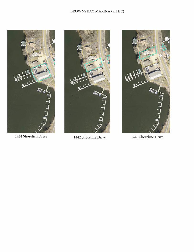
BROWNS BAY MARINA (SITE 2)
1444 Shorelien Drive 1442 Shoreline Drive 1440 Shoreline Drive

ATTACHMENT ONE
Manuevering Space
BSU #'s (W x L) Ft. (Sq. Ft.) Manuevering Space (Sq. Ft.)
1-6 75 x 30 2,250 1,716
7-12 75 x 26 1,950 1,716
13-18 70 x 26 1,820 1,586
19-26 100 x 30 3,000 2,210
27-40 169 x 30 5,070 3,650
Area within crane pad 10 x 65 650 N/A
14,740 10,878
Browns Bay Marina (Site 2) EAW Square Footage Calculations
Dock Structure
25,618
Subtotal Square Feet
Total Square Feet

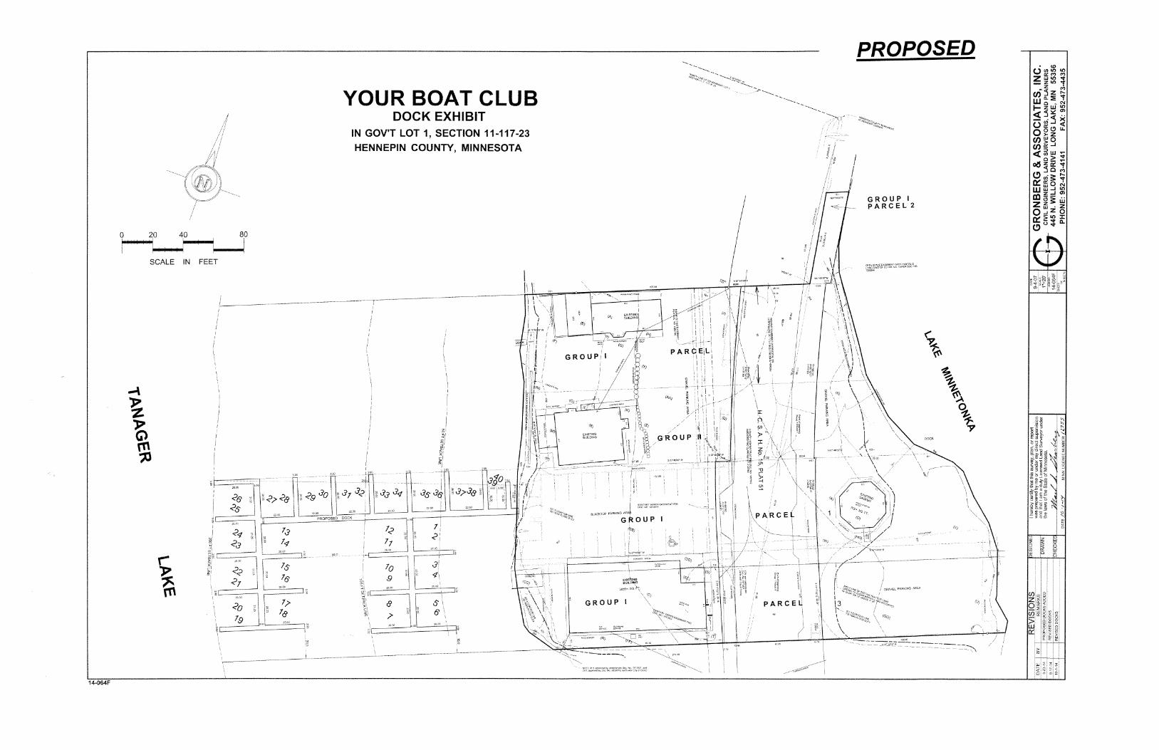

DATE: October 12, 2016
TO: Board of Directors
FROM: Vickie Schleuning, Executive Director
SUBJECT: Code Amendment Minor Reconfiguration (Chapter II)
ACTION
Board consideration of adoption of an ordinance amending Chapter II, Section 2.015,
subdivision 4 regarding minor reconfiguration of nonconforming structures.
BACKGROUND
At the September 28, 2016 Board Meeting, the Board directed staff to prepare an ordinance
amendment for nonconforming structures to allow minor reconfiguration to the slip areas under the
minor change application section Chapter II, Section 2.015, subdivision 4. The purpose of the
amendment is to allow an owner to reasonably increase the width of the boat storage unit (boat slip)
on condition that the overall footprint of the dock does not increase, the number of boat storage
units does not increase, and the aggregate length of boat storage units (boat slips) at the dock does
not increase. For example, current code language prohibits an owner from replacing the dock
fingers between slips with Dolphin poles to accommodate the trend toward wider watercraft under
the minor reconfiguration criteria.
The attorney drafted the attached ordinance amendment to the LMCD code of ordinances
regarding minor changes to nonconforming structures. If the Board approves the code
amendment, this situation would be allowed through minor change application to the Executive
Director so long as there is no expansion of the dock footprint, increase in the number of boats,
or increase in aggregate total length of the slips.
BOARD CONSIDERATIONS
How does this amendment affect other properties (48) that are nonconforming structures?
Is there a benefit or negative impact to Lake Minnetonka or its users?
Is the requirement legal, reasonable, and enforceable?
ITEM 10B
LAKE MINNETONKA CONSERVATION DISTRICT
STATE OF MINNESOTA
ORDINANCE NO. 230
AN ORDINANCE AMENDING THE LAKE MINNETONKA
CONSERVATION DISTRICT CODE OF ORDINANCES
REGARDING MINOR CHANGES TO NONCONFORMING STRUCTURES
THE BOARD OF DIRECTORS OF THE LAKE MINNETONKA CONSERVATION DISTRICT
ORDAINS:
Article I. Legislative Findings. The Board of Directors (“Board”) hereby finds and determines as
follows:
(a) There are approximately forty-eight (48) nonconforming structures on the Lake that are on
file with the Lake Minnetonka Conservation District (“LMCD”);
(b) Lake Minnetonka Code of Ordinances (“Code”) places reasonable restrictions on
nonconforming structures that allow them to continue, but in a way that also respects other
users of the Lake and the goals and policies of the LMCD;
(c) Chapter II, Section 2.015, Subd. 4 allows owners of nonconforming structures to seek
permission to reconfigure the structure by submitting a minor change application to the
LMCD Executive Director;
(d) The Executive Director may approve such requests if they meet certain conditions listed in
the section including: (2) All watercraft stored at the reconfigured facility conform to the
length limitations of Subdivision 9 of [Section 2.015]; and (6) There is no increase in the
square footage of slips outside of 100 feet from the shoreline at elevation 929.4 NGVD and
that;
(e) The restrictions imposed by these conditions can prohibit minor changes to nonconforming
structures that are objectively reasonable in that they may result in a minor increase in the
square footage of slips, but does not result in an overall increase in the footprint of the
structure;
(f) For example, an owner that wishes to replace the fingers between slips with Dolphin poles
to accommodate the trend toward wider watercraft without increasing the number or length
of the slips, or otherwise increasing the footprint of the structure, is reasonable and is
currently prohibited under condition (6) without reducing some other portion of the structure
to avoid any increase in total square footage;
(g) Owners are also deterred from making minor changes to their nonconforming structures
because doing so requires them, under condition (2), to potentially prohibit or remove
watercraft that have previously been allowed to be stored at the structure;
(h) The Board determines that creating a limited exception to the conditions placed on the
minor change reconfiguration of nonconforming structures that do not increase the footprint
of the structure is in the best interest of the LMCD.

Article II. Exception. Chapter II, Section 2.015, Subdivision 4, of the Lake Minnetonka Code of
Ordinances is hereby amended by adding the double-underlined material as follows:
Minor Change Applications Approved by Executive Director. The Executive Director
may approve reconfiguration of non-conforming structures other than Qualified Commercial
Marinas, Qualified Sailing Schools and Qualified Yacht Clubs without a public hearing and
without Board approval if, in addition to the requirements of Subdivision 3 of this Section, all of
the following conditions are met:
1) The proposed reconfiguration does not include a conversion of slides to slips.
2) All watercraft stored at the reconfigured facility conform to the length limitations of
Subdivision 9 of this Section.
3) There is no substantial change in the amount of the Lake obstructed or occupied by the
dock.
4) There is no substantial change in the use of the dock or type of watercraft stored at the
dock.
5) There is no increase in the number of BSUs stored outside of 100 feet from the shoreline
at elevation 929.4 NGVD.
6) There is no increase in the square footage of slips outside of 100 feet from the shoreline
at elevation 929.4 NGVD.
If a proposed reconfiguration does not, in the reasonable determination of the Executive
Director, result in an increase in the footprint of the nonconforming structure, the Executive
Director may approve the minor change application without requiring compliance with
conditions (2) or (6) above, provided the proposed reconfiguration otherwise complies with the
Code. For the purpose of this provision, the “footprint” of the existing nonconforming structure
shall be the total outside dimensions of all parts of the particular structure being reconfigured.
The term does not include other structures that are not connected to or immediately adjacent to
the structure being reconfigured even if the additional structures are part of the same dock
license. No approval of a minor change application shall be deemed to exclude compliance with
conditions (2) or (6) unless such exclusion is expressly stated in the approval issued by the
Executive Director. A reconfiguration approved under this provision shall not constitute an
expansion of a nonconforming use under Section 2.10, subdivision 3, and if it results in an
increase in slip size, a special density license shall not be required under Section 2.05,
subdivision 9.
The Executive Director may approve reconfiguration of non-conforming Qualified Commercial
Marina structures, Qualified Sailing School structures and Qualified Yacht Club structures
without a public hearing and without Board approval if, in addition to all provisions of
Subdivision 3.a) of this Section, all of the following conditions are met:
1) The proposed reconfiguration does not include a conversion of slides to slips.
2) There is no substantial change in the amount of the Lake obstructed or occupied by the
dock.
The Executive Director may refer any application to the Board and shall refer any application
that the Executive Director proposes to deny.
Article III. Effective Date. This ordinance shall be effective the day following its publication or a
summary thereof.

Adopted this 12th
day of October, 2016.
BY THE BOARD OF DIRECTORS
James Jay Green, Chair
ATTEST:
Gregory J. Thomas, Secretary
Date of Publication: October 18, 2016
Effective Date: October 19, 2016

ITEM 10C