lake huron binational partnership action plan
TRANSCRIPT

Lake Huron Binational Partnership
ACTION PLAN

2004 Lake Huron Binational Partnership Action Plan
i
Table ofContents
Table of ContentsSection 1: Executive Summary .......................................................................................................... 1
Section 2: Introduction ....................................................................................................................... 1
2.1 The Lake Huron Basin ............................................................................................................. 1
2.2 The Partnership ....................................................................................................................... 2
2.3 The Issues ............................................................................................................................... 3
Section 3: Fish and Wildlife Contaminants ...................................................................................... 1
3.1 Contaminants in Fish ............................................................................................................... 1
3.1.1 Contaminant Trends ..................................................................................................... 1
3.1.2 Fish Consumption Advisories ....................................................................................... 3
3.2 Contaminants in Wildlife .......................................................................................................... 5
3.2.1 Fish-Eating Birds .......................................................................................................... 5
3.2.2 Other Wildlife ............................................................................................................... 6
3.3 References .............................................................................................................................. 8
Section 4: Aquatic Ecosystem ........................................................................................................... 1
4.1 Lake Huron Aquatic Foodweb ................................................................................................. 1
4.2 Fishery Management Goals .................................................................................................... 1
4.2.1 Spawning and Nursery Habitats ................................................................................... 2
4.2.2 Shoreline Processes .................................................................................................... 3
4.2.3 Food Web Structure and Invasive Species .................................................................. 3
4.2.4 Water Quality ............................................................................................................... 3
4.3 Invasive Species ...................................................................................................................... 3
4.3.1 Sea Lamprey ................................................................................................................ 4
4.3.2 Round Goby ................................................................................................................. 4
4.3.3 Ruffe ............................................................................................................................. 4
4.3.4 Spiny Water Flea .......................................................................................................... 5
4.3.5 Zebra and Quagga Mussels ......................................................................................... 5
4.3.6 Other Aquatic Nuisance Species .................................................................................. 5
4.4 References .............................................................................................................................. 5
Section 5: Areas of Concern in Lake Huron ..................................................................................... 1
5.1 Spanish Harbour, Ontario ........................................................................................................ 1
2004 Lake Huron Binational Partnership Action Plan
ii
Table ofContents
5.2 Saginaw River/Bay, Michigan .................................................................................................. 1
5.3 Binational Area of Concern: St. Marys River ........................................................................... 2
Section 6: Other Lake Huron Issues ................................................................................................. 1
6.1 Low Water Levels .................................................................................................................... 1
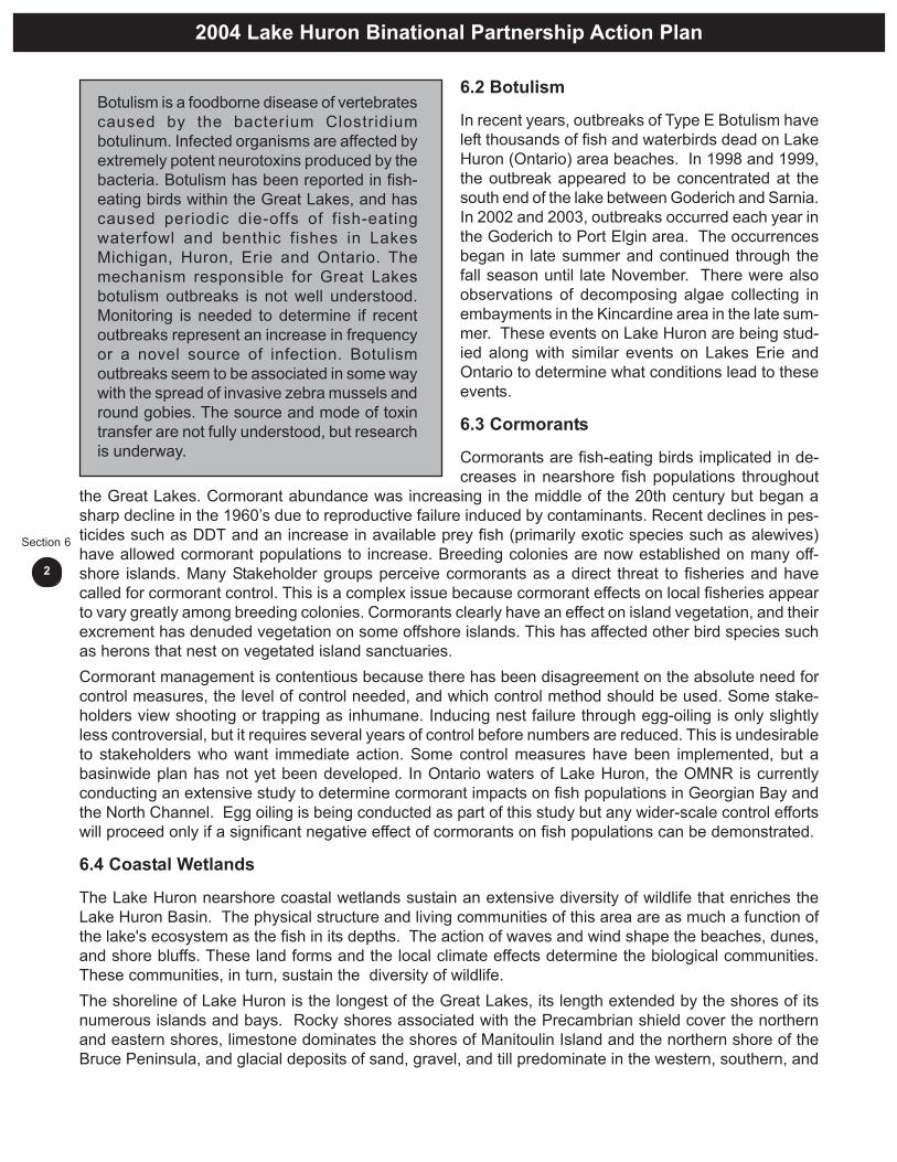
6.2 Botulism ................................................................................................................................... 2
6.3 Cormorants .............................................................................................................................. 2
6.4 Coastal Wetlands .................................................................................................................... 2
6.5 Bacterial Contamination........................................................................................................... 3
6.6 Blue-green Algae Blooms in Georgian Bay ............................................................................. 3
6.7 Tributary Access for Spawning Fish ......................................................................................... 3
6.8 Aquaculture .............................................................................................................................. 4
6.9 Global Climate Change ........................................................................................................... 4
6.10 Low-Level Contaminants ....................................................................................................... 5
Section 7: Action Plan ........................................................................................................................ 1
7.1 Canadian Watershed ............................................................................................................... 1
7.1.1 Activities Addressing Contaminants in Fish and Wildlife .............................................. 1
7.1.2 Activites to Increase Understanding ofEcosystem Change, Biodiversity and the Impact of Exotic Species ............................ 1
7.1.3 Activities Addressing Fish and Wildlife Habitat/Populations ......................................... 2
7.1.4 Activities Addressing Nutrient and Bacteria Issues ...................................................... 3
7.1.5 Activities at Areas of Concern
7.1.5.1 Spanish Harbour ............................................................................................... 4
7.1.5.2 Severn Sound ................................................................................................... 4
7.2 U.S. Watershed ....................................................................................................................... 4
7.2.1 Addressing Contaminated Sediments in Areas of Concern ......................................... 4
7.2.1.1 Saginaw Bay ..................................................................................................... 5
7.2.1.2 St. Marys River .................................................................................................. 5
7.2.2 Partners in the Restoration of the Lake Huron Fishery ................................................ 5
7.2.2.1 Lake Trout Rehabilitation .................................................................................. 5
7.2.2.2 Lake Sturgeon Restoration ............................................................................... 6
7.2.2.3 Monitoring the Growth and Condition of Lake Whitefish .................................. 6
7.2.2.4 Managing the Lake Huron Treaty Fishery ......................................................... 6
2004 Lake Huron Binational Partnership Action Plan
iii
Table ofContents
7.2.2.5 Monitoring Fish Community Health ................................................................... 6
7.2.3 Targeting the Saginaw Bay Aquatic Ecosystem ........................................................... 6
7.2.3.1 Walleye Recovery in Saginaw Bay ................................................................... 6
7.2.3.2 Restoring Fish Passage to Saginaw Bay Tributaries ........................................ 7
7.2.4 Wildlife and Habitat Management ................................................................................ 7
7.2.4.1 The Great Lakes Piping Plover ......................................................................... 7
7.2.5 Understanding the Lower Food Web ........................................................................... 7
7.2.5.1 Benthic Macroinvertebrate Community of the Open Waters of Lake Huron ..... 7
7.2.5.2 Changes in the Lower Food Web of Saginaw Bay ........................................... 7
7.2.6 Monitoring the Threat of Invasive Species ................................................................... 7
7.2.7 Community Planning Efforts......................................................................................... 8
7.2.7.1 The Misery Bay Initiative, A Plan to Protect Coastal Ecosystems ..................... 8
7.2.8 Improving Data Management and Sharing .................................................................. 8
7.2.8.1 Lake Huron GIS ................................................................................................ 8
7.2.8.2 Bald Eagle Monitoring Database ...................................................................... 8
7.2.8.3 Improving Coastal Wetland Restoration througha Conservation Lands Inventory ....................................................................... 8
7.2.8.4 Ranking System for Great Lakes Islands ......................................................... 8
7.3 Long-Term Projects ................................................................................................................. 9
7.4 References .............................................................................................................................. 9

ES
Executive
Sum
mary
Executive Summary

2004 Lake Huron Binational Partnership Action Plan
1
Section 1
Section 1: Executive SummaryIn 2002, the Binational Executive Committee formally endorsed the formation of a Lake Huron BinationalPartnership in order to coordinate environmental activities in the Lake Huron basin. The United StatesEnvironmental Protection Agency, Environment Canada, Michigan’s Departments of Environmental Qualityand Natural Resources and Ontario’s Ministries of Environment and Natural Resources form the core ofthe Partnership by providing leadership and coordination. However, a flexible membership is being promotedwhich is inclusive of other agencies and levels of government, Tribes/First Nations, non-governmentorganizations and the public on an issue-by-issue basis.The approach to Lake Huron differs from the Lakewide Management Plans (LaMPs) of Lakes Superior,Michigan, Erie and Ontario in that there has been no systematic assessment of beneficial use impairments,identification of causes, definition of critical pollutants, determination of chemical sources and loadings,and release of a report for comment. The alternative approach focuses on areas of obvious importance,tackles these as priorities in the first action plans, and will expand over time to include other activities thatinvestigate the less severe or obvious issues in the lake. Three priority issues - contaminants in fish andwildlife; biodiversity and ecosystem change; fish and wildlife habitat - were given priority for immediateaction while other issues will be tracked and added as the Partnership pursues this process of updatingand expanding activities over time.Actions in Areas of Concern or resulting from specific local priorities are also part of the Partnership’sagenda. These actions, which are being managed domestically, include the continued efforts at SaginawBay, monitoring of Spanish Harbour’s recovery and science based investigations of bacterial and algaefouling of beaches along the south-east shore of the lake. Other Lake Huron concerns include: low waterlevels, botulism, cormorant populations, blue-green algae blooms in Georgian Bay, aquaculture, emergingcontaminant concerns and global climate change.This 2004 Action Plan provides information on priority issues, trends, goals, research, monitoring, on-the-ground activities and future needs. Consistent with an adaptive management approach, it is not fullycomprehensive, but will be expanded and added to over time. Contaminant trends in fish and wildlife havebeen summarized, current knowledge of changes in the fish community, threats to aquatic life and habitathave been outlined along with proposed draft environmental objectives for fisheries management. Moredetail on any of these topics can be obtained from source documents and fact sheets developed by thePartnership. The Action Plan section itself highlights the activities already underway and planned over theshort term (2 years) and future efforts over the long term (5 years). These actions are geared towardsimproving knowledge, understanding function and change, monitoring trends, and restoring, rehabilitatingand protecting the Lake Huron ecosystem.

2
Introduction
Introduction

2004 Lake Huron Binational Partnership Action Plan
1
Section 2
April 22, 2004
Section 2: Introduction2.1 The Lake Huron Basin
The Lake Huron drainage basin is unique in the Great Lakes system, both as the lake in the middle of theGreat Lakes and due to its abundance of shoreline habitat. Lake Huron has over 30,000 islands and, asa result, has the longest shoreline of any lake in the world. Its expansive open-lake waters, large watershedarea and relatively undisturbed nearshore areas support a high diversity of aquatic and riparian species ofimportance to the Great Lakes region.The Lake Huron watershed is home to about 2.5 million people. Both sides of Lake Huron have relativelylow human population densities. As a result Lake Huron retains much of its historic fish and wildlifehabitat. Saginaw Bay, Georgian Bayand the North Channel still supportsome of the most extensive highquality coastal habitat in the GreatLakes.The U.S./Canada border dividesLake Huron almost in half. TheCanadian portion of the Lake,including Georgian Bay, is wholly inthe Province of Ontario. The U.S.portion is located entirely within theState of Michigan. The drainagebasin on the Ontario side (86,430square kilometers or 33,500 squaremiles) covers twice the area, hasapproximately five times theshoreline, and roughly 300,000 fewerresidents than in Michigan.The Lake Huron basin contains nomajor metropolitan areas. Thelargest urban centers in the basin areSudbury and Sarnia on the Ontario side and Saginaw andBay City on the Michigan side. With populations under100,000, these urban areas are relatively small compared tourban areas in the more populous Great Lake basins. TheLake Huron basin is heavily forested in the northern portionand then becomes increasingly agricultural in the south withits urbanized areas along the southernmost portion of the lake.Much of southern part of the Huron basin is devoted tointensive cultivated field crops and, beef and dairy farms,particularly in the "thumb" area of Michigan, along the BrucePeninsula and the southeast shore of the main basin. Miningof limestone, nickel, uranium, copper, platinum and gold hasbeen an important activity in the northern portion of the LakeHuron basin. Though residential land use makes up a smallpercentage of total land use, much rural development hasoccurred along the shoreline. In the past 20 years there hasbeen increasing development pressure for cottages and year-
Figure 2.1
Figure 2.2

2004 Lake Huron Binational Partnership Action Plan
2
Section 2
April 22, 2004
round retirement properties. Undoubtedly, the next 20 years will bring more as urban populations growand the retired population increases.In 1987, four Areas of Concern (AOCs) were identified in the Lake Huron basin in addition to the St. MarysRiver. Within the basin two AOCs, Saginaw Bay, Michigan, and Spanish Harbour, Ontario remain. Thecauses of impairment within the AOCs are being addressed, and habitat, fish and wildlife populations, andenvironmental quality are recovering. Canada and Ontario have recognized Spanish Harbour as an "Areain Recovery" where all remedial actions have been implemented and the environment will take some timeto respond and the goals to be achieved. Severn Sound, Ontario was delisted as an AOC in 2003 and theCollingwood Harbour AOC, also in Ontario, was delisted in 1994. The St. Marys River is being addressedthrough a binational process.Lake Huron is the third largest freshwater lake in the world in terms of area, and the sixth largest in volumeand boasts the largest island (Manitoulin) of any freshwater lake on Earth. The retention time for water inLake Huron is 22 years, and the average depth is 59 metres (195 feet). This long retention time and largesurface area have resulted in the build up of persistent substances that bioaccumulate in fish and wildlife.The diverse shoreline of Lake Huron is the longest of the Great Lakes, its length extended by the shoresof its numerous islands. Rocky shores associated with the Precambrian shield cover the northern andeastern shores, limestone dominates the shores of Manitoulin Island and the northern shore of the BrucePeninsula, and glacial deposits of sand, gravel, and till predominate in the western, southern, and south-eastern portions of the shore. Shoreline and inshore habitats are correspondingly diverse.Along the Canadian shore of Lake Huron, loss of wetland habitat on a large scale has not occurredbecause most of the shoreline is sparsely populated. Losses tend to be concentrated around the smallurban centers that dot the shore. Within the last 10 years, there has been incremental and site-specificloss of wetland area from agricultural encroachment and cottage development. Over 40 species of rareplants, 5 rare reptile species, and 59 fish species use the coastal wetlands of Lake Huron.
2.2 The Partnership
In 2002, the federal, state and provincial agencies that manage binational environmental activities underthe Great Lakes Water Quality Agreement formally endorsed the formation of a Lake Huron BinationalPartnership in order to prioritize and coordinate environmental activities in the Lake Huron basin. TheUnited States Environmental Protection Agency (USEPA), Environment Canada (EC), Michigan’sDepartments of Environmental Quality (MDEQ) and Natural Resources (MDNR) and Ontario’s Ministriesof Environment (MOE) and Natural Resources (MNR) form the core of the Partnership, by providingleadership and coordination. However the Partnership emphasizes the importance of maintaining a flexiblemembership which is inclusive of other agencies and levels of government, Tribes/First Nations, non-government organizations and the public on an issue-by-issue basis.This partnership builds upon the efforts begun by the Michigan Department of Environmental Quality’sOffice of the Great Lakes in their Lake Huron Initiative. Through the Lake Huron Initiative priority actionswere identified for the Lake Huron Basin regarding use impairments, critical pollutants, habitat, andbiodiversity. The Lake Huron Initiative developed an Action Plan for Lake Huron in 2000 and updated in2002 which outlined priority programs and initiatives. Many of these activities are now being addressedthrough the Lake Huron Binational Partnership.The Partnership facilitates information sharing and priority setting for binational environmental protectionand restoration activities of importance in the Lake Huron basin and also promotes cooperation andcollaboration towards shared objectives that can not be accomplished by individual agencies alone.Public consultation is an important component of the Partnership’s activities in the Lake Huron basinparticularly on a project specific level. Those individuals and organizations which have a direct interest inan issue will be targeted to participate or provide input to project direction and implementation. Theagencies in the Partnership will work with existing mechanisms and groups as much as possible to consultand provide information to the public. The Lake Huron mailing list, through which general information will

2004 Lake Huron Binational Partnership Action Plan
3
Section 2
April 22, 2004
be provided, includes municipal governments, environmental organizations, special interest groups andmembers of the public. A series of stand-alone fact sheets has been produced on the following topics:The Binational Partnership; Contaminants in Fish; Contaminants in Wildlife; Developing EnvironmentalObjectives for Fish Communities; Lake Huron GIS; and Changes in the Lake Huron Fish Community.The Partnership is an action-oriented process for identifying priority issues and efforts needed to ensurea healthy Lake Huron watershed. The binational work plan includes U.S., Canadian, and joint actionsfocused on short term project implementation and longer-term priority setting.
2.3 The Issues
The participants of the Partnership have agreed upon three initial binational issues to focus on:• contaminants in fish and wildlife,• biodiversity and ecosystem change, and• fish and wildlife habitat.
These key issues were given priority for immediate action while other issues will be tracked and added asthe Partnership pursues an iterative process of updating and expanding activities over time.The subject areas that are being addressed through the efforts of the Partnership include:
• Status and trends of contaminants in fish and wildlife, chemicals causing fish consumptionrestrictions. The identification of potential sources and implementation of reduction measures.
• Scope and causes of observed changes in ecosystem structure and function. The impact ofinvasive species on food web dynamics, fish communities and biodiversity.
• Status and trends of fish and wildlife populations and habitat. The evaluation, protection andrestoration of critical habitat such as wetlands, fish spawning areas and nesting sites forwaterbirds.
While these topics are being addressed binationally, other issues are managed domestically. These includethe restoration of beneficial uses in the Areas of Concern, and other local issues such as fouling ofbeaches by algae and bacteria. The Partnership facilitates the sharing of information between countrieson these domestic issues.In order to streamline activities and minimize costs, the Partnership will work closely with existing programs.One example of this effort is the close tie to the Great Lakes Fishery Commission's Lake Huron TechnicalCommittee and activities such as the development of Environmental Objectives. The basin’s size andmultiple bi-national political jurisdictions, require coordination among programs as well as special basinwideand local initiatives. While governmental agencies are in a position to provide leadership, success willdepend on leveraging both governmental and non-governmental organization involvement and resources.Success will also require engaging local governments whose authority and local decision-making collectivelyhas a significant impact on the natural resources and sustainability of communities throughout the LakeHuron Basin.

Fish and WildlifeContaminants
3
Fish & W
ildlifeC
ontaminants

2004 Lake Huron Binational Partnership Action Plan
1
Section 3
Section 3: Fish and WildlifeContaminants
3.1 Contaminants in Fish
The Michigan Department of Environmental Quality and the Ontario Ministry of the Environment collectand analyze many species of fish to determine whether chemicals are present in quantities that may be ofconcern to those eating sport-caught fish. Contaminants such as mercury, toxaphene, dioxins, andpolychlorinated biphenyls (PCBs) can accumulate in fish, wildlife and humans and could be harmful to adeveloping fetus, young child or breast-feeding baby.The sport fish contaminant monitoring program is the largest testing and advisory program of its kind inNorth America. Both Michigan and Ontario have major fish contaminant analysis programs in place whichinclude coverage of the Lake Huron watershed. These programs annually evaluate the available fishcontaminant information and place advisories on the consumption of specific species of fish depending onthe levels of contaminants found.
3.1.1 Contaminant Trends
From the late 1970’s to the early 1990’s, concentrations of persistent, bioaccumulative substance such asPCB, DDT, dieldrin, dioxins, and furans declined significantly in Lake Huron lake trout. However, whileconcentrations of DDT continued to decline up until 1995, PCB concentrations have not declined significantlysince the mid 1980s (Figure 3.1). As with other trends, concentrations decreased significantly in the late1970s but have remained relatively stable since.
Continuing sources of contaminants are primarily from sediments contaminated by historic discharges,airborne deposition, industrial and municipal discharges and land runoff. Contaminants enter Lake Huronthrough a variety of pathways including direct discharges, atmospheric deposition, and tributary discharge.Pesticides such as DDT, Toxaphene, Mirex, Chlordane and Aldrin/Dieldrin have been banned from use inthe U.S. and Canada; however, they are still cycling within the environment through run-off, sedimentresuspension and long range atmospheric transport. The large surface area of Lake Huron, like the otherGreat Lakes, has made it particularly vulnerable to atmospheric deposition of contaminants. Lake Huronhas a large surface area and relatively few local contaminant point sources. Pollutant loadings to LakeHuron from water sources are lowest of all the Great Lakes but air sources are highest. The persistenceof contaminants in the aquatic environment varies from substance to substance.The breakdown or transformation of contaminants into forms that are inactive or less toxic may takeanywhere from minutes to years. As a result, for the more persistent substances such as PCBs and DDT,
Figure 3.1
2004 Lake Huron Binational Partnership Action Plan
2
Section 3
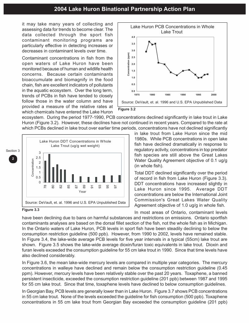
it may take many years of collecting andassessing data for trends to become clear. Thedata collected through the sport fishcontaminant monitoring programs areparticularly effective in detecting increases ordecreases in contaminant levels over time.Contaminant concentrations in fish from theopen waters of Lake Huron have beenmonitored because of human and wildlife healthconcerns. Because certain contaminantsbioaccumulate and biomagnify in the foodchain, fish are excellent indicators of pollutantsin the aquatic ecosystem. Over the long term,trends of PCBs in fish have tended to closelyfollow those in the water column and haveprovided a measure of the relative rates atwhich chemicals have entered the Lake Huronecosystem. During the period 1977-1990, PCB concentrations declined significantly in lake trout in LakeHuron (Figure 3.2). However, these declines have not continued in recent years. Compared to the rate atwhich PCBs declined in lake trout over earlier time periods, concentrations have not declined significantly
in lake trout from Lake Huron since the mid1980s. While PCB concentrations in open lakefish have declined dramatically in response toregulatory activity, concentrations in top predatorfish species are still above the Great LakesWater Quality Agreement objective of 0.1 ug/g(in whole fish).Total DDT declined significantly over the periodof record in fish from Lake Huron (Figure 3.3).DDT concentrations have increased slightly inLake Huron since 1995. Average DDTconcentrations are below the International JointCommission's Great Lakes Water QualityAgreement objective of 1.0 ug/g in whole fish.In most areas of Ontario, contaminant levels
have been declining due to bans on harmful substances and restrictions on emissions. Ontario sportfishcontaminants analyses are based on the dorsal fillet section of the fish, not the whole fish as in Michigan.In the Ontario waters of Lake Huron, PCB levels in sport fish have been steadily declining to below theconsumption restriction guideline (500 ppb). However, from 1990 to 2002, levels have remained stable.In Figure 3.4, the lake-wide average PCB levels for five year intervals in a typical (55cm) lake trout areshown. Figure 3.5 shows the lake-wide average dioxin/furan toxic equivalents in lake trout. Dioxin andfuran levels exceeded the consumption guideline for 55 cm lake trout in 1990. Since that time levels havealso declined considerably.In Figure 3.6, the mean lake-wide mercury levels are compared in multiple year categories. The mercuryconcentrations in walleye have declined and remain below the consumption restriction guideline (0.45ppm). However, mercury levels have been relatively stable over the past 20 years. Toxaphene, a bannedpersistent insecticide, exceeded the consumption restriction guideline (201 ppb) between 1987 and 1995for 55 cm lake trout. Since that time, toxaphene levels have declined to below consumption guidelines.In Georgian Bay, PCB levels are generally lower than in Lake Huron. Figure 3.7 shows PCB concentrationsin 55 cm lake trout. None of the levels exceeded the guideline for fish consumption (500 ppb). Toxapheneconcentrations in 55 cm lake trout from Georgian Bay exceeded the consumption guideline (201 ppb)
Figure 3.2
Figure 3.3

2004 Lake Huron Binational Partnership Action Plan
3
Section 3
between 1996 and 1997. Since that time, toxaphenelevels have decreased to below the consumptionrestriction guidelines in Georgian Bay. In the 2003-04 guide, dioxins and furans were the cause of onlyone consumption restriction (65-75 cm lake trout).Overall, the percentage of consumption restrictionsfor fish from Georgian Bay (15.5%) was much lessthan those for Lake Huron (26%).In the North Channel, the percentage of fishconsumption restrictions (16.5%) is also much lowerthan in Lake Huron. The PCB levels in lake trout inthe North Channel have declined since 1983(Figure 3.8). Recent levels are well below theconsumption restriction guideline (500 ppb).
Toxaphene levels in 55cm lake trout exceeded the consumption guideline in 1987 and 1989 but havedecreased considerably since that time.
3.1.2 Fish Consumption Advisories
Fish consumption advisories are based on guidelines developed through research and review of toxicologicaldata. Both Michigan and Ontario have determined a safe dose for an extensive list of contaminants. Thisamount is referred to as a tolerable daily intake. It is then determined what proportion of the tolerable dailyintake comes from each of the environmental pathways (e.g. air, water, different types of food), includingsport fish consumption. A series of estimates and calculations are then done to determine if fish are
Figure 3.5 Dioxin/furan levels in 55 cm lake trout fromLake Huron (Source: OMOE, 2004).
Figure 3.4 PCB concentrations in 55 cm lake troutfrom Lake Huron (Source: OMOE, 2004).
Figure 3.6 Mercury concentrations in 45 cm walleyefrom Lake Huron (Source: OMOE, 2004).
Figure 3.7 PCB concentrations in 55 cm lake trout fromGeorgian Bay (Source: OMOE, 2004).
Figure 3.8 PCB concentrations in 55 cm lake trout fromthe North Channel (Source: OMOE, 2004).

2004 Lake Huron Binational Partnership Action Plan
4
Section 3
suitable for consumption. Fish Consumption Advisories are meant to inform consumers of the potentialconcerns.In comparison to the other Great Lakes, contaminant concentrations are relatively low in Lake Huron.Nevertheless, fish consumption advisories exist for the open lake and all Areas of Concern (St. MarysRiver, Saginaw Bay and the Spanish River). Advisories differ by species, size and location, so it is importantto check advisories in effect for the appropriate area.In the Ontario waters of Lake Huron (including Georgian Bay, North Channel and St. Marys River) generally,the restrictions on trout, salmon, carp and channel catfish are caused by PCBs (Figure 3.9). The restrictionson other species are usually caused by mercury. In total, over 20 percent of the advice given for sport fishfrom Lake Huron results in some level of consumption restriction.In the Michigan waters of Lake Huron (including Saginaw Bay and the St. Marys River) generally, therestrictions on trout, salmon, carp, channel catfish, burbot, northern pike, walleye, white bass, white suckers,
white perch and yellow perch are caused by PCBs. The other restrictions are caused by chlordane, dioxins,or mercury.Based on the most recent information the current status of sport fish consumption advisories for bothOntario and Michigan are as shown below:PCBs – In Michigan waters, almost every sample collected from Lake Huron exceeded the trigger levelused by the Michigan Department of Community Health to issue sport fish consumption advisories for theprotection of women of child bearing age and children under 15 years of age. Sport fish consumptionadvisories cover 15 species of Lake Huron fish. In addition, fish from several Lake Huron tributaries arecovered by sport fish consumption advisories due to elevated concentrations of PCBs.Toxaphene - Several species of Lake Huron fish including lake trout, lake whitefish and brown trout hadtoxaphene concentrations above the Ontario Ministry of Environment’s sport fish consumption advisorytrigger level.Dioxins - Fewer dioxin analyses have been conducted on Lake Huron fish because of the relatively highcost of analyses. However, lake trout, lake whitefish and carp have dioxin concentrations above thetrigger level used by both the Michigan Department of Community Health and the Ontario Ministry ofEnvironment to issue sport fish consumption advisories. In addition, fish from the Saginaw River watershedare covered by advisories due to elevated concentrations of dioxin.Chlordane - Concentrations of chlordane in Lake Huron lake trout occasionally exceed the sport fishconsumption advisory trigger level (Figure 3.10).
Figure 3.9 Causes of fish consumption advisories for the Lake HuronWatershed (2003-04 Guide to Eating Ontario Sport Fish(MOE)).

2004 Lake Huron Binational Partnership Action Plan
5
Section 3
Mercury - Only the methylated form ofmercury bioaccumulates in fish tissue and anumber of characteristics influence themethylation of mercury in the aquaticenvironment. Mercury methylation occursmore readily in inland lakes than in the GreatLakes. Therefore, sportfish consumptionadvisories due to elevated levels of mercuryare more prevalent in fish from inland lakeswithin the Lake Huron watershed rather thanfish from Lake Huron.DDT/PBB - Concentrations of DDT and PBBrarely exceed sportfish consumptionadvisory trigger levels in Lake Huron fish.The only area of the Lake Huron watershedwhere concentrations are elevated is in thePine River in the Saginaw River watershed.
3.2 Contaminants in Wildlife
In the early 1970s, fish-eating birds (eagles, gulls, cormorants, etc.) on Lake Huron suffered widespreadcontaminant-induced reproductive failure, declining populations and eggshell thinning. With reductions inloadings of persistent toxic contaminants, such as PCBs, most fish-eating bird populations have recovered;numbers of herring gulls, Caspian terns, black-crowned night-herons and double-crested cormorantshave increased significantly. However, some contaminant-associated problems, e.g. birth defects, impairedphysiological responses and/ or reproductive failure, continue to occur in a small percentage of thepopulations in local areas.It is important to monitor temporal and spatial trends in contaminants in these species and to identifypotential problem areas and sources. Recently, to obtain more detailed geographical information, monitoringprograms have included other aquatic-feeding species such as reptiles, amphibians, mink and otter.Contaminants such as PCBs, chlordane, dioxins and DDT have a strong association with reproductionand health in these species and this information, together with the fish-eating bird monitoring data, providesa more complete picture of the wildlife health effects of contaminants in the Lake Huron ecosystem.
3.2.1 Fish-Eating Birds
The Canadian Wildlife Service (CWS) ofEnvironment Canada has been monitoringcontaminant levels in herring gull eggs at 15 GreatLakes sites since 1974. The three Lake Huron sitesare: Channel-Shelter Island, Double Island andChantry Island (Figure 3.11).The program tracks temporal and spatial trends incontaminant levels and effects in a top avian aquaticpredator in the Great Lakes food web. Contaminantslevels have declined dramatically at all three CWSLake Huron sites since 1974, although the rates ofdecline for some compounds slowed during the1990s (Figure 3.12). In spite of these declines, PCBand dioxin levels in gull eggs from Channel-ShelterIsland continued to remain elevated compared toother Great Lakes sites. While major point sources
Figure 3.10
Figure 3.11 Canadian Wildlife Service Annual Herring GullMonitoring Sites
Source: EnvironmentCanada CWS

2004 Lake Huron Binational Partnership Action Plan
6
Section 3
of chemical contaminants are not found on the Canadian side of Lake Huron, atmospheric deposition,agricultural run-off, re-suspension of sediments and leaching of soils from landfill sites contribute to thesteady state that has been evident since the 1990s. Year-to-year fluctuations in contaminant levels resultfrom changes in food abundance associated with/or changes in weather conditions (Fox et al. 1990,Ewins et al. 1992).The Michigan Department of Environmental Quality (MDEQ) began a similar annual gull egg monitoringproject in 1999, augmenting the CWS work. Their sites include the outer Saginaw Bay, Alpena, St. Ignaceand Sault Ste. Marie. MDEQ data are reviewed each year for new parameters for which wildlife should beanalyzed.High concentrations of brominated diphenyl ethers (BDEs) in Great Lakes herring gulls have recentlybeen identified as a concern (Norstrom et al. 2003). Total BDE in herring gull eggs sampled from Doubleand Chantry Islands in 2000 were low (308-320 ug/kg) in comparison to other Great Lakes sites (1400 ug/kg in Green Bay), largely due to their remoteness from large urban/heavy industrial centres. Little isknown with regard to the toxic effects of brominated diphenyl ethers in humans and wildlife.In addition to Herring gull egg monitoring, the CWS occasionally measures contaminants in eggs fromdouble-crested cormorants, ring-billed gulls, black-crowned night herons, great black-backed gulls andseveral species of terns. Generally, levels of contaminants in these species from Lake Huron sites werelower than other Great Lakes sites (Pekarik et al 1998; CWS unpublished).In hunted waterfowl from Georgian Bay and Sault Ste. Marie, Braun et al. (1999) found that organochlorines,PCBs and mercury in pectoral muscle were low and did not pose a risk to wildlife. One exception was acommon merganser from Sault Ste. Marie with the highest PCB concentrations of all waterfowl andgamebirds collected across Canada from 1987 to 1995. The reason for these high levels is unknown.Bald eagles are a very sensitive top level predator and are often considered the ultimate contaminantindicator species. They have begun to return to the Great Lakes and can be used as indicators ofcontaminant trends by sampling contaminants in blood. Elevated levels of contaminants have been foundin some eaglet blood samples from Georgian Bay (Donaldson et al. 1999) and Lake Huron watersheds(Saginaw River, Shiawassee Cutoff) although the 1999-2001 samples were significantly lower than in1987-1992 (Roe et al. 2004)Exposure to heavy metals has been identified as a concern for bald eagles since several bald eaglesfound dead in the last few years in Ontario have had elevated levels of both mercury and lead in theirbodies (Badzinski and Richards, 2002). Adult longevity and nest occupancy turn-over rates, including ageof replacement birds, are other important factors which will ultimately determine how successful nestingbald eagles are on the shores of Lake Huron.Ospreys are often used as local indicators in areas where there are few or no eagles. During 1991-1993DDE concentrations in Osprey eggs and plasma were significantly higher in Georgian Bay than at inlandsites in Ontario (Martin et al. 2003). Mean concentrations of DDE were lower than the critical value (4.2ug/g) associated with significant eggshell thinning, however 20% of eggs from Georgian Bay were abovethis level. In terms of heavy metals, all samples taken from the St. Marys River and Georgian Bay (1991-1993) had mercury levels below those expected to cause adverse effects on reproduction. Thus, theCanadian Lake Huron osprey population does not appear to be affected by the current level of contaminants.
3.2.2 Other Wildlife
Snapping turtles are ideal monitors of wetland health due to their sedentary nature, their position as a toppredator in the food chain and their ability to accumulate high levels of contaminants over the course oftheir long lives. Geographic variation in contaminant levels have been shown to be similar to the variationreported for herring gull eggs at other Great Lakes sites (Struger et al. 1985). Mink and otter both live inwetland habitat near the shoreline and consume various amounts of fish in their diet. Mink are one of themost sensitive mammals to PCBs, resulting in reproductive problems and death. Trends in mink populationshave followed those of fish-eating birds; the population began to decline in the mid 1950s and was lowest

2004 Lake Huron Binational Partnership Action Plan
7
Section 3
Figure 3.12 Temporal Trends in Levels of Contaminants in Herring Gull Eggs at Three Lake Huron Annual Monitor Colonies.

2004 Lake Huron Binational Partnership Action Plan
8
Section 3
in the early 1970s but recovered somewhat in the 1980s. Otter have a lower rate of reproduction andtherefore, are slower to recover.Mink and otter are also sensitive indicators of mercury in the aquatic environment. Total mercuryconcentrations in otter tissues from near Parry Sound were higher than those in mink tissues, possiblydue to their more piscivorous-based diet compared to mink (Klenavic, 2004). Mercury levels in otter hairwere within the range found in studies in southern Ontario. Levels reported for Lake Huron otter were wellbelow action thresholds.In summary, wildlife information has indicated that PCBs, chlordane, dioxins and DDT are a concern in theLake Huron basin although, with the exception of Saginaw Bay (PCBs, dioxin), concentrations are lowcompared to the other Great Lakes. Concentrations have declined significantly since the early 1970s butstill remain at levels associated with deformities and reproductive effects in several local watersheds inMichigan, especially Saginaw Bay. Data collected in Ontario’s wildlife species were generally not at levelsof concern although sporadic elevated measurements support the need for continued ongoing monitoring.
3.3 References
Fox, G.A., Allan, L.J., Weseloh, D.V., and Mineau, P. 1990. The diet of herring gulls during the nestingperiod in Canadian waters of the Great Lakes. Can.J. Zool. 68: 1075-1085.Ewins, P.J., Weseloh, D.V.C. and Mineau, P. 1992. Geographical distribution of contaminants and productivitymeasures of herring gulls in the Great Lakes: Lake Huron 1980. J.Great Lakes Res. 18(2): 316-330.Pekarik, C., Weseloh, D.V., Barrett, G.C., Simon, M., Bishop, C.A., and Pettit, K.E. 1998. An atlas ofcontaminants in the eggs of fish-eating colonial birds of the Great Lakes (1993-1997). Can. Wildl. Ser.Tech. Rep. Ser. No. 321.245pp.Donaldson, G.M., Shutt, J.L. and Hunter, P. 1999. Organochlorine contamination in bald eagle eggs andnestlings from the Canadian Great Lakes. Arch. Environ. Contam. Toxicol. 36: 70-80.Roe, A., Birrenkott, A., Bowerman, W., Bush, D., and Sikarskie, J.. 2004 Michigan Wildlife ContaminantTrend Monitoring – Year 2001 Annual Report. Nestling Bald Eagles. Michigan Dept. of EnvironmentalQuality and Michigan State University.Badzinski, D.S. and Richards, I. 2002. Southern Ontario bald eagle monitoring project – 2002 final report.Bird Studies Canada, Environment Canada, Ontario Ministry of Natural Resources. 15 pp.Martin, P.A., de Solla, S.R., and Ewins, P. 2003. Chlorinated hydrocarbon contamination in osprey eggsand nestlings from the Canadian Great Lakes basin, 1991-1995. Ecotoxicology 12: 209-224.Struger, J., Weseloh, D.V., Hallett, D.J. and Mineau, P. 1985. Organochlorine contaminants in herring gulleggs fro the Detroit and Niagara Rivers and Saginaw Bay (1978-1982): contaminant discriminants. J.Great Lakes Res. 11:223-230.Klenavic, K.M. 2004. Mercury levels in wild mink (Mustela vison) and river otter (Lutra canadensis) inOntario and Nova Scotia: Relations to age, sex, parasitism and body condition. M.Sc. Thesis. TrentUniversity, Peterborough, Ontario, Canada.Bowerman, W.W. 1993. Regulation of Bald Eagle (Haliaeetusleucocephalus) Production in the GreatLakes Basin: An Ecological and Toxicological Approach. PhD. Thesis. Michigan State University, EastLansing, MI, USA.Bowerman, W.W., D.A. Best, J.P. Giesy, M.C. Shieldcastle, M.W. Meyer, S. Postupalsky, and J.G. Sikarski.2003. Association between Regional Differences in PCBs and DDE in Blood of Nestling Bald Eagles andReproductive Productivity. Environ. Toxicol. Chem. 22:371-376.Day, R. and S. Walsh. 2000. Michigan Fish Contaminant MonitoringProgram: 2000 Annual Report. SurfaceWater Quality Division, Michigan Department of Environmental Quality Report #MI/DEQ/SWQ-00/122.DeVault, D.S., R. Hesselberg, P.W. Rodgers and T.J. Feist. 1996. Contaminant Trends in Lake Trout andWalleye from the Laurentian Great Lakes. J. Grt. Lks. Res. 22(4):884-8895.

Aquatic Ecosystem
HistoricLake HuronOffshoreEcosystem
The original ecosystem had fewer predators and many more prey fish species.
CurrentLake Huron OffshoreEcosystemThe current ecosystem has many more predators and Both predators and prey are dominated by introduced species.
Many of the original deepwater cisco species in Lake Huron are extinct.
4
Aquatic
Ecosystem
2004 Lake Huron Binational Partnership Action Plan
1
Section 4
Section 4: Aquatic EcosystemSince French explorer Étienne Brûlé first saw Lake Huron in 1612, the lake ecosystem has undergonemany changes. Among the most significant change to the fish community have been the invasion ofrainbow smelt (Osmerus mordax) in the 1920’s, and alewife (Alosa pseudoharengus) and sea lamprey(Petromyzon marinus) in the 1930s. Sea lamprey predation and overfishing led to the collapse of laketrout (Salvelinus namaycush) by the 1950’s (although two remnant stocks barely survived). With nopredators to control alewife and smelt populations their numbers exploded and nuisance die-offs of alewifecommonly littered beaches during the 1960s.The turnaround came with sea lamprey control in the 1960s which allowed the survival of stocked Pacificsalmon (Oncorhynchus spp.), lake trout and other predators. Restocking controlled both smelt and alewifepopulations, prevented nuisance alewife die-offs and resulted in exceptionally good fishing.
4.1 Lake Huron Aquatic Foodweb
The original Lake Huron ecosystem had lake trout as the main predator together with burbot (Lota lota) inthe deeper waters, and walleye (Sander vitreus) the main nearshore area predator. The historic preybase was dominated by lake herring (or cisco) (Coregonus artedii) and a number of other species ofdeepwater ciscos (Coregonus spp.), with sculpins (Cottus spp. and Myoxocephalus quadricornis), lake(Coregonus clupeaformis) and round whitefish (Prosopium cylindraceum) contributing to a lesser extent.The historic Lake Huron off-shore ecosystem had fewer predators and many more prey fish species. Thecurrent ecosystem has many more predators and both predators and prey are dominated by introducedspecies. Many of the original deepwater cisco species in Lake Huron are extirpated. (Refer to the sectiondivider for illustration of aquatic ecosystem.)Today chinook salmon (Oncorhynchus tshawytscha) are the dominant consumer in the lake, feedingmainly on non-native forage (alewife are their main prey with smelt being second) and lake trout are still asignificant factor due to continued stocking. The abundance of both alewife and smelt can fluctuatesignificantly between years which can influence growth rates and survival of predators.Six sites of natural reproduction of lake trout have been documented on Lake Huron and one has beendeemed rehabilitated. Despite this level of success much work is needed to rehabilitate lake trout to evena small portion of their former abundance across the lake.On Lake Huron the impact of industrialization and human population density has not been as great as onsome of the other Great Lakes. The lake is, however, vulnerable from future impacts due to it’s beingwithin easy commuting distance of much higher population areas and is a popular destination for millionsof cottagers, tourists and anglers. The mounting development pressures on Lake Huron from improvedhighways, and diminishing resources in other locations, will likely increase harvest and developmentpressure and strain the achievement of resource sustainability. Continued vigilance is needed to insurethat future development on Lake Huron is done in a sound ecologically sustainable manner while efforts toseek solutions to existing problems continue to occur.
4.2 Fishery Management Goals
Fish Community Objectives (FCO) for Lake Huron were developed in 1995, and were in most cases yieldtargets by species based on historic commercial fishery landings from 1912-1940. An emerging realizationis that historic harvest, and even current levels for some species, may not be sustainable in the long-term.Historic commercial fishery practices such as switching to different targeted species, fishing different fishstocks, changes in fishing effort and fishing power may all have masked the steady decline of fish populationsover this historic time period.In addition, the current ecosystem may not be as productive as in the past since non-native prey speciesare not as efficient in utilizing the primary and secondary production of the lake as were historic species,

2004 Lake Huron Binational Partnership Action Plan
2
Section 4
such as the diversity of ciscos that once inhabited the lake. The introduction of non-native species such aszebra (Dreissena polymorpha) and quagga mussels (Dreissena bugensis) and the spiny water flea(Bythotrephes cederstroemi) may also divert much of the primary and secondary production of the lake todifferent pathways, making it unavailable to top predators.Non-native salmonids which feed almost exclusively on alewife and smelt, are likely less efficient at utilizingproductivity than indigenous lake trout, in that lake trout has a much more varied diet and would historicallyhave utilized some portion of the available benthic prey in addition to forage fish to support their populationsize.Taken in context, historic yield can provide an idea of what a fully recovered fish community might sustainrather than a specific target. The Great Lakes Fishery Commission (GLFC) currently facilitates the publishingof State of the Lake Reports for each of the Great Lakes on a five year rotation. A critical review of the lakestatus relative to FCOs is currently being conducted and FCOs will be updated as required.To better facilitate the cooperative management of fisheries resources a framework for inter-jurisdictionalcoordination of fisheries management based upon an ecosystem context was developed. This “ecosystemapproach” to fisheries management recognizes that the resources of the Great Lakes must be managedas a whole, that healthy fish communities require functioning, diverse habitats and clean water. FCOs forLake Huron were completed in 1995 and described what was considered a “desirable” fish communitybased upon accepted ecological concepts and guiding principles. In order to support these FCOs,Environmental Objectives (EOs) are being developed to describe the biological, chemical and physicalneeds of these desired fish communities. The rehabilitation of Saginaw Bay, which once accounted for asignificant proportion of lake wide yield of fish species, and making stream habitats currently blocked byman-made barriers available to migrating fish, rank as key targets for future habitat work.With multiple resource agency input, the development of draft EOs was initiated in 2002 and the currentversion is undergoing critical review. These draft EOs provide a summary of the major environmentalimpediments to achieving FCOs in Lake Huron. A summary of the draft Environmental Objectives isprovided below:
4.2.1 Spawning and Nursery Habitats
Maintain, protect and restore the integrity and connectivity of wetland spawning, nursery andfeeding areas throughout the Lake Huron basin. Coastal wetlands throughout Lake Huron providecritical spawning, nursery and feeding habitat for a variety of fish species. Northern pike (Esox lucius) andmuskellunge (Esox masquinongy) spawn exclusively in wetland areas whereas other species such asyellow perch (Perca flavescens), walleye, and minnow species use these areas as nursery and feedingsites. Historical losses of Lake Huron wetlands through drainage, infilling and other physical alterationshave been significant. Many remaining wetlands are degraded or no longer accessible due to shorelinearmoring.Protect and restore connectivity and functionality of tributary spawning and nursery areasthroughout the Lake Huron Basin. The Lake Huron watershed is one of the largest in the Great Lakeswith numerous rivers and streams draining into the basin. The principal spawning and nursery habitats fora variety of species including lake sturgeon (Acipenser fluvescens), walleye, pacific salmonids(Oncorhynchus spp.), and suckers (Catostomus spp.) are found in these tributaries. Unfortunately, riversand streams are some of the most altered and disrupted habitats in the Lake Huron basin. Many of thewatersheds draining into Lake Huron have barriers to upstream access and have flow regimes that havebeen altered as a result of watershed land-use changes or hydro-electric generation needs.Protect and restore reef spawning areas throughout the Lake Huron Basin. Lake Huron is a deepoligotrophic lake with a fish community that was historically dominated by deep dwelling species such aslake trout, whitefish and ciscoes. Most of these species utilize offshore or nearshore reefs for spawningpurposes. Nearshore and offshore reefs are one of the most common habitat features throughout theLake Huron basin. For the most part these habitats have not been physically altered to the same extent as
2004 Lake Huron Binational Partnership Action Plan
3
Section 4
other habitat types, however, the colonization of these habitats by invasive species such as zebra musselsand round goby (Neogoblus melanostomus) has accelerated in recent years and may in time degrade thequality of these habitats.
4.2.2 Shoreline Processes
Protect and rehabilitate nearshore habitats and reestablish the beneficial structuring forces ofnatural water exchanges, circulation, and flow that they provide. The alteration of nearshore areasdue to human activities has been widespread throughout the Lake Huron basin but has been mostpronounced in the populated areas in the southern part of the basin. Shoreline straightening, infilling,dredging, and other such activities alter nearshore currents, increase erosion and deposition of finesediments and leads to the loss of habitat diversity. Since a majority of fish species inhabiting the basinuse nearshore areas at some point in their life-cycle altering these areas results in the loss of fish productionand change in fish community structure.
4.2.3 Food Web Structure and Invasive Species
Protect and where possible enhance or restore fish community structure and function by promotingnative species abundance and diversity and avoiding further invasive species introductions. Inparticular, protect and restore keystone predators to control exotic species and cultivate a foodweb favorable to reproduction of native species. Fish communities throughout the Lake Huron basinhave undergone substantive change over the last century. Historically, the offshore fish communities werecharacteristic of a large, deep oligotrophic lake with lake trout and burbot being the dominant predatorsand a variety of cisco species being the dominant prey species. In the nearshore waters, a relativelygreater diversity of predators (walleye, northern pike, muskellunge, bass (Micropterus spp.)) were presentas well as benthivores (sturgeon, suckers, channel catfish (Ictalurus punctatus)) and forage fish (herring,yellow perch, cyprinids). A variety of factors have been implicated in the loss or extinction of species in thebasin and prominent among them is the proliferation of invasive species such as lamprey, alewife, rainbowsmelt, and zebra mussels.
4.2.4 Water Quality
Protect and restore water quality throughout the Lake Huron basin, especially in the Areas ofConcern and reduce or remove contaminant burdens from the fish community in order to avoidreductions in fish production and native species biodiversity, and to maintain fishable, swimmable,aesthetically unaltered waters for the enjoyment of future generations. Water quality throughout theLake Huron basin has shown gradual improvement since the early 1970’s. Some localized nutrientenrichment problems exist in Saginaw Bay and southeastern main basin and in northeastern ManitoulinIsland. Acid rain and heavy metal contamination is still a localized issue in some parts of the North Channeland Georgian Bay. Consumption advisories due to contaminant levels are in place throughout the basinfor a variety of fish species.
4.3 Invasive Species
Lake Huron has been dramatically and forever changed by the invasion of non-native species, which havedecimated native fish populations and in some cases permanently impacted fish communities. Invasivespecies are defined as species that do not originate in the Lake Huron ecosystem and have been introducedeither intentionally or accidentally. Invasive species threaten the diversity and abundance of native speciesand the ecological stability of infested waters.The introduction of invasive species into Lake Huron has altered or disrupted existing relationships andecological processes. This disruption can cause significant changes to the Lake Huron ecosystem suchas alterations of food webs, nutrient dynamics, reproduction, sustainability, and biodiversity. Invasivespecies have few natural enemies such as pathogens, parasites and predators. Without co-evolved parasitesand predators, they out-compete and even displace native populations. Not only do invasive species
2004 Lake Huron Binational Partnership Action Plan
4
Section 4
compete with native species for food and habitat, they may also increase cycling of persistentbioaccumulative chemicals in the food chain. For example, research has shown that zebra mussels andround gobies are contributing to the cycling and bioaccumulation of PCBs (Jude 1996).The recent invasion of zebra and quagga mussels, round gobies, the spiny water flea, white perch (MoroneAmericana) and ruffe (Gymnocephalus cemuus) into Lake Huron heightens the uncertainty for expectationsfrom the ecosystem. Recently Diporeia hoyi (scud), a native invertebrate has declined significantly inabundance, especially in southern Lake Huron. There is a suspicion that the Diporeia decline may berelated to the invasion of zebra mussels. Diporeia is a key diet item of lake whitefish and other desirablesport and commercial fish species.The following is a description of a number of invasive species having a significant impact on the LakeHuron aquatic ecosystem.
4.3.1 Sea Lamprey
The sea lamprey has been a serious problem in the Great Lakes for more than 50 years. An adult lampreycan kill up to 40 pounds of fish in just 12 to 20 months. The St. Marys River, which flows between LakesSuperior and Huron has become the most important spawning area for lampreys in the Great Lakes.Successful rehabilitation of Lake Huron lake trout populations has been hindered because of the highnumber of sea lamprey. Without question the sea lamprey problem in northern Lake Huron, associatedwith increased lamprey production from the St. Marys River, is the most severe impediment to a healthyfish community in the lake. By the1990’s the St. Marys River was producing more sea lampreys than allother Great Lakes spawning tributaries combined.Cost-effective sea lamprey control on the St. Marys, once thought to be impossible, may now be withinreach because of a special program developed by biologists and research scientists working under thedirection of the Great Lakes Fishery Commission. During 1998 – 1999, more than 840 hectares of the St.Marys River were treated with Bayluscide 3.2 percent Granular Sea Lamprey Larvicide. Additionaltreatments of sea lamprey “hot-spots” in the river have been conducted in more recent years. Thesetreatments reduced the number of larval sea lampreys in the river by nearly 45 percent. Enhancedtrapping and release of sterile male lampreys in the river reduced the reproduction potential by an estimated92 percent. Although the Great Lakes Fishery Commission’s fish community objective for sea lamprey(75 percent reduction) was not met for year 2000, the objective for 2010 (90 percent reduction) is attainable.However, funding for sea lamprey control remains at approximately 65 percent of that needed to fully fundthe program.
4.3.2 Round Goby
The round goby are a small fish that feed chiefly on bivalves, amphipod, crustaceans, and small fish andfish eggs (Jude 1996). Consumption studies of fish suggest round gobies might have a detrimentalimpact on native species through competition for food and predation on eggs and young fish. To helpcontrol the expansion of the goby into other waterways, river barrier systems are being implementedalong with aggressive public education programs. Unfortunately, no effective measures have been foundto decrease established populations of goby.
4.3.3 Ruffe
The ruffe was first identified in Lake Huron in 1995 in Thunder Bay near Alpena, Michigan. The Ruffeadapts well to various environments, matures quickly, and spawns over an extended period of time. Witha high level of adaptability, ruffe populations are on the rise, yet they have not spread from the ThunderBay region of Lake Huron.

2004 Lake Huron Binational Partnership Action Plan
5
Section 4
4.3.4 Spiny Water Flea
The spiny water flea was first discovered in Lake Huron in 1984 and is believed to have entered the watersof the Great Lakes through discharged ballast water (Mills et al 1993). Although its average length israrely more than 1.5 centimeters, this predacious zooplankter can have a profound effect on a lake’splankton community. The spiny water flea has colonized all offshore areas of the lake.
4.3.5 Zebra and Quagga Mussels
Zebra mussels reproduce rapidly and are able to form dense layered colonies of over one million persquare meter. Zebra mussels are a serious threat to Lake Huron ecosystem because they have tremendousfiltering capacity for sediments and phytoplankton (Fanslow et al 1995). In many regions of the GreatLakes zebra mussels have had severe impacts on many native unionids and are of special concern tothreatened and endangered species of bi-valves. Also, zebra mussels are a serious concern becausethey contribute to the cycling of contaminants by removing PCBs from the sediments and reintroducingthem into the food web (Jude 1996). Quagga mussels are similar to zebra mussels in many respects butdo prefer deeper water. They therefore have the potential to detrimentally impact aquatic species that usethe deeper portions of the lake.
4.3.6 Other Aquatic Nuisance Species
Eurasian watermilfoil (Myriophyllum spicatum) is one of the most common species found in Saginaw Bay.Populations have thrived since the introduction of zebra mussels that have contributed to higher waterclarity. Decreased light levels allow for fewer species to survive. Eurasian watermilfoil also reroutesnutrients from plankton to uprooted plants, depriving energy to the fish community. Purple loosestrife(Lythrum salicaria) is a perennial wetland plant that is impacting Lake Huron wetland ecosystems bychanging the structure, function and productivity of the wetlands. The plant forms dense monoculturestands sometimes hundreds of acres in size. Purple loosestrife can displace native vegetation and threatenthe biotic integrity of wetland ecosystems. Cercopagis pengoi, the fishhook water flea, is one of the mostrecent invasive species to Lake Huron. Cercopagis are a problem because they tangle lines in bothrecreational and commercial fisheries and have a large appetite for zooplankton (Ontario Federation ofHunters and Anglers 1999). Further ecological disruptions have not been completely determined and,therefore, Cercopagis are being closely watched.In the future, additional non-native species will likely be introduced into the Great Lakes food web and willhave unknown effects making it even more difficult, if not impossible, to define reasonable expectationsfor an ever changing ecosystem.
4.4 References
Mills, Edward L. et al, 1993. Exotic Species in the Great Lakes: A History of Biotic Crises and AnthropogenicIntroductions. J. Great Lakes Res. 19(1):1-54.Fanslow, D.L., Nalepa, T. F., and G. A. Lang. 1995. Filtration rates of the zebra mussel (Dreissenapolymorpha) on natural seston from Saginaw Bay, Lake Huron. J. Great Lakes Res. 21(4):489-500.Ontario Federation of Anglers and Hunters. August 1999. Cercopagis pengoi invades Lake Ontario Factsheet.Jude, D. J. 1996. Gobies: Cyberfish of the 90s. Center for the Great Lakes and Aquatic Sciences,Michigan Sea Grant Program.

Areas of Concern
5
Areas of Concern
2004 Lake Huron Binational Partnership Action Plan
1
Section 5
Section 5: Areas of Concernin Lake Huron
In 1987, four AOCs were identified within the Lake Huron watershed, as well as the St. Marys River.Collingwood Harbour and Severn Sound in Canada were delisted in 1994 and 2003 respectively. Monitoringis ongoing in these areas to ensure that environmental quality is maintained. Each of the remaining AOCsare being addressed through on-going programs, as described below. For more information on AOCs,see the following websites:http://gldev.on.ec.gc.ca/water/raps/map_e.htmlhttp://www.epa.gov/glnpo/aoc/index.html
5.1 Spanish Harbour, Ontario
At the Spanish Harbour AOC, all recommended actions were completed and in 1999, the area was thefirst in the Great Lakes to be recognized as being an Area in Recovery. Heavy metal contamination in theriver and harbour are being monitored for natural recovery. Results from a recent survey (October 2003)are being compiled and will be used to generate modeling predictions to estimate how long recovery maytake. A six year muskellunge re-introduction program involving many partner organizations is now in thefinal assessment stages.
5.2 Saginaw River/Bay, Michigan
The Saginaw Bay Watershed is one of Michigan's most diverse areas-its rich resources support agriculture,manufacturing, tourism, outdoor recreations, and a vast variety of wildlife. The watershed is 8,709 squaremiles in size and is America's largest contiguous freshwater coastal wetland system. Contaminatedsediments, fish consumption advisories, degraded fisheries and loss of significant recreational values arethe major reasons for this AOC’s designation. Saginaw Bay priorities include remediation of PCBcontaminated sediment, nonpoint pollution control, wetland restoration, and habitat restoration.The Stage 1 Saginaw River/Bay Remedial Action Plan (RAP) process began in July 1986 and was completedin September 1988. Following substantial progress, an updated Saginaw River/Bay RAP was developedin 1994. More recently, the Measures of Success report (2001) provides a foundation for redirecting andrefocusing efforts. It recommends a list of targeted restored conditions that should be viewed as stepstoward the delisting of the Saginaw Bay/River AOC. Preparation of the updated Saginaw River/Bay RAPis being done through the committee structure of the Partnership for the Saginaw Bay Watershed.Major ongoing efforts are addressing contaminated sediments and floodplain soils within the Tittabawasseeand Saginaw River. Sediments and floodplain soils in the Saginaw River Watershed contain a variety oforganic compounds, including dioxins, furans, and PCBs. The 1998 $28.2 million natural resources damagessettlement funded the removal of 342,433 cubic yards of contaminated sediments from the river, protectionof coastal wetlands (1677 acres), and restoration of coastal wetland and lakeplain prairie on 391 acres.Portions of this settlement used as match for a $1M North American Wetlands Conservation Act (NAWCA)grant that is improving habitat on approximately 3,000 acres. Also, plans are being finalized for restorationof the hydrology of Tobico Marsh, a 900 acre wetland immediately adjacent and connected to SaginawBay. This project is expected to improve spawning opportunities for Saginaw Bay northern pike.Existing data from US Army Corps of Engineers, U.S. EPA, and Michigan DEQ indicate that, at somelocations, dioxin contamination exceeds human health risked-based regulatory levels and ecological riskbased screening levels. Michigan Department of Environmental Quality is actively characterizing SaginawRiver sediments and floodplain soils for compounds of regulatory and environmental significance. Thedata collected will assist in decision making regarding short-term protection of human health and the

2004 Lake Huron Binational Partnership Action Plan
2
Section 5
environment and long-term remediation of the Saginaw River and Saginaw Bay. It will also provide inputto similar decision-making on the Shiawassee River, a tributary of the Saginaw River. Michigan DEQ isengaging the community as an integral part of addressing the dioxin issues in the watershed and Area ofConcern. A Community Advisory Panel (CAP) has been established to bring stakeholders together andadvance remediation.
5.3 Binational Area of Concern: St. Marys River
The St. Marys River is a 112 km connecting channel between Lakes Superior and Huron and is subject tomany activities under the binational Remedial Action Plan. Accomplishments on the Canadian side haveincluded the development of wetland protection strategies, the recovery of walleye populations, the designof habitat features in the city's waterfront development, and installation of an activated sludge treatmentfacility to reduce the oxygen demand and suspended solids in the discharge water of the St. Marys Papermechanical pulp mill. The Environmental Management Agreement with Algoma Steel, to be renewed in2004, has likewise resulted in many improvements to both air and wastewater discharges. Current projectsinclude: funding for the design of a strategy for contaminated sediment; review of delisting criteria;wastewater characterization study; and wetland conservation. Future challenges include the need to controlinputs from the century-old Algoma slag site, long-term sea lamprey control efforts to restore impairedfisheries, and the finalization and implementation of a sediment management plan.Priorities of the St. Marys River on the Michigan side are cleanup of the Cannelton Tannery Superfundsite, sea lamprey control, and elimination of combined sewer overflows. The Cannelton Superfund sitehas been restored for re-use by the city of Sault Ste. Marie and its citizens. Once remediated, the site maysupport light industry, residential homes, or park areas. Certain use restrictions will apply to various partsof the site to prevent contamination from affecting human or ecosystem health. The sea lamprey controlefforts will help restore impaired fisheries in the St. Marys River as well as northern Lake Huron and LakeMichigan. This will be a long-term, continuing effort since the opportunistic lamprey can take quick advantageof any lapse in larvae and adult control measures. Combined sewer separation in Sault Ste. Marie, Michiganhas already eliminated the worst of the occasional overflows of sewage to the St. Marys River in Michiganwaters. Continued work on this will eventually stop all potential for untreated sewage entering the river,even in the worst run-off events.

Other Lake Huron Issues
6
Oth
er
La
keH
uron Issues
2004 Lake Huron Binational Partnership Action Plan
1
Section 6
Section 6: Other Lake HuronIssues
There are a range of other issues in the Lake Huron basin which are being addressed by other programsor are beyond the current scope of the Partnership’s priority issues. They are no less significant, however,so they are either being addressed domestically, through other programs or they are being tracked andover time, specific actions to address these issues may be incorporated into the Binational PartnershipAction Plan.
6.1 Low Water Levels
Unlike the other Great Lakes, water levels in Lakes Huron (and Michigan since they share the same level)are approaching historic lows. Cyclic water level fluctuation is a natural occurrence, but recent low levelscould be a regional response to global climate change. Many shoreline property owners have welcomedlower water levels since it has exposed increased amounts of beach and shoreline and reduced thepotential for any property damage from erosion. Others are very concerned about exposed shorelinesand the loss of existing wetlands which are being dried out as water levels drop. The low water levels thathave recently occurred in Lakes Huron and Michigan are not being seen to the same extent in the otherGreat Lakes.This situation created a novel regulatory issue. On the Michigan shoreline, receding water levels exposedshoreline mud flats and beaches that were colonized by emergent wetland vegetation. This representsrestoration of a natural condition that has not existed for many years, and in many areas newly emergedwetlands represent a substantial increase in essential wetland habitat for fishes and waterfowl. However,some property owners, accustomed to sandy beaches and open lake, regard the new wetlands withdisfavor and have attempted to secure beach grooming permits. Several cases of unpermitted vegetationremoval have led to enforcement actions. The State of Michigan’s Wetlands Protection and the GreatLakes Submerged Lands parts of Michigan’s Natural Resources and Environmental Protection Act wererecently amended to permit property owners to carry out limited vegetation removal, except in areasdesignated as Environmental Areas by the MDEQ, where threatened or endangered species may beimpacted, or, in designated critical dune areas. The recent amendments to Michigan law designatesSaginaw Bay as a pilot area that allows riparian property owners to remove certain types of vegetationfrom exposed bottomlands, after receiving a letter of approval from the MDEQ certifying that specifiedcriteria are met. Vegetation removal in this pilot area is typically limited to 50 percent of a property owner’sshoreline, or 100 feet, whichever is greater. A permit from the U.S. Army Corps of Engineers is required formechanical removal of vegetation.At the same time in some Canadian waters, particularly in Georgian Bay and the North Channel wheredifferent shoreline conditions exist, many wetlands have been significantly reduced in size through drying.This has reduced availability of critical spawning habitat for fish species such as northern pike, muskel-lunge and smallmouth bass. Currently, research is being conducted to assess impacts of these low waterlevels and compare the current situation to the historic state.
2004 Lake Huron Binational Partnership Action Plan
2
Section 6
6.2 Botulism
In recent years, outbreaks of Type E Botulism haveleft thousands of fish and waterbirds dead on LakeHuron (Ontario) area beaches. In 1998 and 1999,the outbreak appeared to be concentrated at thesouth end of the lake between Goderich and Sarnia.In 2002 and 2003, outbreaks occurred each year inthe Goderich to Port Elgin area. The occurrencesbegan in late summer and continued through thefall season until late November. There were alsoobservations of decomposing algae collecting inembayments in the Kincardine area in the late sum-mer. These events on Lake Huron are being stud-ied along with similar events on Lakes Erie andOntario to determine what conditions lead to theseevents.
6.3 Cormorants
Cormorants are fish-eating birds implicated in de-creases in nearshore fish populations throughout
the Great Lakes. Cormorant abundance was increasing in the middle of the 20th century but began asharp decline in the 1960’s due to reproductive failure induced by contaminants. Recent declines in pes-ticides such as DDT and an increase in available prey fish (primarily exotic species such as alewives)have allowed cormorant populations to increase. Breeding colonies are now established on many off-shore islands. Many Stakeholder groups perceive cormorants as a direct threat to fisheries and havecalled for cormorant control. This is a complex issue because cormorant effects on local fisheries appearto vary greatly among breeding colonies. Cormorants clearly have an effect on island vegetation, and theirexcrement has denuded vegetation on some offshore islands. This has affected other bird species suchas herons that nest on vegetated island sanctuaries.Cormorant management is contentious because there has been disagreement on the absolute need forcontrol measures, the level of control needed, and which control method should be used. Some stake-holders view shooting or trapping as inhumane. Inducing nest failure through egg-oiling is only slightlyless controversial, but it requires several years of control before numbers are reduced. This is undesirableto stakeholders who want immediate action. Some control measures have been implemented, but abasinwide plan has not yet been developed. In Ontario waters of Lake Huron, the OMNR is currentlyconducting an extensive study to determine cormorant impacts on fish populations in Georgian Bay andthe North Channel. Egg oiling is being conducted as part of this study but any wider-scale control effortswill proceed only if a significant negative effect of cormorants on fish populations can be demonstrated.
6.4 Coastal Wetlands
The Lake Huron nearshore coastal wetlands sustain an extensive diversity of wildlife that enriches theLake Huron Basin. The physical structure and living communities of this area are as much a function ofthe lake's ecosystem as the fish in its depths. The action of waves and wind shape the beaches, dunes,and shore bluffs. These land forms and the local climate effects determine the biological communities.These communities, in turn, sustain the diversity of wildlife.The shoreline of Lake Huron is the longest of the Great Lakes, its length extended by the shores of itsnumerous islands and bays. Rocky shores associated with the Precambrian shield cover the northernand eastern shores, limestone dominates the shores of Manitoulin Island and the northern shore of theBruce Peninsula, and glacial deposits of sand, gravel, and till predominate in the western, southern, and
Botulism is a foodborne disease of vertebratescaused by the bacterium Clostridiumbotulinum. Infected organisms are affected byextremely potent neurotoxins produced by thebacteria. Botulism has been reported in fish-eating birds within the Great Lakes, and hascaused periodic die-offs of fish-eatingwaterfowl and benthic fishes in LakesMichigan, Huron, Erie and Ontario. Themechanism responsible for Great Lakesbotulism outbreaks is not well understood.Monitoring is needed to determine if recentoutbreaks represent an increase in frequencyor a novel source of infection. Botulismoutbreaks seem to be associated in some waywith the spread of invasive zebra mussels andround gobies. The source and mode of toxintransfer are not fully understood, but researchis underway.

2004 Lake Huron Binational Partnership Action Plan
3
Section 6
south-eastern portions of the shore. Shoreline and inshore habitats are correspondingly diverse.The nearshore area habitat represents a warm- or coolwater ecosystem that, at one time, encircled thelake. It was undoubtedly a small part of total lake volume, but it supported many locally important fisheriesfor bass, perch, walleye and pike. Many of these fisheries were compromised early on through overexploitation and loss of wetlands, and have largely been forgotten. Where they remain, they are animportant resource.Many nearshore areas of Lake Huron have been altered due to human influences. The once naturalshorelines offered fish and wildlife significant habitat for all of their life stages. Due to development incoastal areas, many areas now have shoreline protection structures. In many cases, the narrow band oftransitional vegetation is now gone.No comprehensive estimates of coastal wetland loss for Lake Huron are available. On the northern shoreof Lake Huron, loss of wetland habitat on a large scale has not occurred because most of the shoreline issparsely populated and remote. Most losses tend to be concentrated around small urban centers on thelakeshore. Within the last 10 years, there has been incremental and site-specific loss of wetland areafrom agricultural encroachment, cottage development, road construction, dredging and channelization. Arecent study of Saginaw Bay estimates that in seven of eight coastal counties at least 40 percent ofwetlands have been lost.
6.5 Bacterial Contamination
The watershed of Lake Huron along its south-east shore (Sauble Beach to Sarnia) is a draw for thousandsof tourists and cottagers annually as it boasts some of the finest freshwater beaches in the world. Highlevels of nutrients and bacteria (E. coli) along the beaches and in the tributaries have led to numerouspostings of beaches warning of unsafe conditions for swimming. These conditions have existed for manyyears yet have received heightened attention due to recent media coverage. Complaints from residentsabout algae have been less consistent, and are sporadic geographically and over time with some yearsmuch worse than others. The relative contributions of sources of nutrients and bacteria have not beenspecifically quantified, however agricultural practices, municipal wastewater, septic systems and wildlifesources are all contributors.Canadian agencies have formed a subgroup under the Lake Huron Binational Partnership to address thisimportant domestic issue. The south-east shore working group has been working since July 2002 tocoordinate activities and conduct research into the sources and causes of these impairments along theshoreline. More recently, the provincial Ministries of the Environment and Agriculture and Food haveintensified their efforts under a science committee to investigate microbial sources to the lakeshore and tobetter understand the contributions from different sources.
6.6 Blue-green Algae Blooms in Georgian Bay
Recent occurrences of blue-green algae blooms in the protected bays and inlets of Georgian Bay haveled to increased concern about inputs of nutrients from shoreline cottages and developments. In the fallof 2003, Sturgeon Bay, a small inlet along the north-east coast of Georgian Bay just north of Parry Sound,was subject to a warning from the local health unit advising residents to restrict use of water from the bayfor any purposes including swimming, drinking, bathing, and any other domestic uses. This has alarmedlocal residents and cottagers and has increased concern amongst the many other Georgian Bay locationsthat may be subject to the same limnological conditions and inputs as Sturgeon Bay. Further monitoringand research is planned for 2004 and the Township of the Archipelago will be launching an educationcampaign to inform local residents about what they can do to reduce nutrient releases from their proper-ties.
6.7 Tributary Access for Spawning Fish
Many fishes need to migrate between different habitats throughout their life histories. In the past, LakeHuron was connected to diverse array of stream and inland lake habitats. Historically, tributaries were

2004 Lake Huron Binational Partnership Action Plan
4
Section 6
important sources of cool, high quality water, and they served as spawning and nursery habitats for manyspecies. Fish were excluded from many of these areas in the 1800’s through construction of mill damsand later through hydroelectric facilities. As shown in Figure 6.1 [below] dams now fragment many streamswhere historical spawning occurred for adfluvial fish (live in the open waters of the Great Lakes and usetributaries for spawning). For example, 106 dams occur in the watershed of the Au Sable River, Michigan,a high quality trout stream. Included are six large hydroelectric dams, which impound nearly all thehighest gradient rapids on the lower river. These dams impound over 26 percent of the river's mainstreamwarm downstream reaches lessening their suitability for coldwater fishes and, prevent Great Lakes fishesfrom accessing 93 percent of the mainstream Au Sable River (Zorn and Sendek 2001). Many importantfisheries and spawning rapids are no longer accessible.
6.8 Aquaculture
In Lake Huron, rainbow trout are stocked into floating pens at small size, fed prepared diets, and har-vested when they reach marketable size. Currently these operations occur only in Ontario waters of LakeHuron and are mostly located in the North Channel. These operations support high fish concentrationsthat produce fecal material that can degrade water quality and alter benthic environments below penrearing facilities. Proper siting of these facilities is critical, but aesthetic concerns can arise even in areaswith suitable water circulation.Additional concerns regarding these operations include introduction of unwanted organisms, diseases, orparasites. These can be introduced in shipments of eggs or young fish, and fish are known to escaperearing facilities. Rainbow trout were introduced into Lake Huron well over 100 years ago and have be-come naturalized, thus escaped pen reared fish would not represent a new introduction; however, interac-tions between pen reared escaped fish and naturalized rainbow trout are unknown. Despite these prob-lems the industry provides a desired product with significant economic benefits and is working with vari-ous levels of government to develop technologies and best management practices to ensure ecologicalsustainability.
6.9 Global Climate Change
Global climate change may already be affecting Lake Huron by altering water levels. If current trendscontinue, further reductions in water level may be expected. This would exacerbate navigation and beachvegetation issues. A wide range of fisheries issues could occur if Lake Huron experienced additionalwarming: expansion of the near-shore fish community into deeper areas, increases in fish populationsthat are presently temperature limited (particularly alewife), and range expansion of both native and intro-duced fishes that are presently restricted to Lake Erie are possible. Global climate change may also
Figure 6.1

2004 Lake Huron Binational Partnership Action Plan
5
Section 6
cause greater demand for fresh water, and any reduction or loss of fresh water in other regions of NorthAmerica would heighten water demand and place greater pressure on Great Lakes residents to allowwater withdrawal. While this might benefit the region economically, it opens the door to ecological, eco-nomic, and social issues that have not been considered.
6.10 Low-Level Contaminants
Recent advances in chemical detection techniques have revealed the presence of low concentrations ofchemical contaminants that were previously not known to be present. Studies in other aquatic systemshave detected a wide range of chemicals including personal care products (soaps and perfumes), humanand veterinary drugs (antibiotics), natural and synthetic hormones, plasticizers, insecticides, fire retar-dants, and caffeine from coffee drinkers. Concentrations of these chemicals almost never exceed stan-dards set for drinking water, but there are no standards for many substances because it was not knownthat they were even present. The primary concern with low-level contaminants is that they may serve asendocrine disrupters that affect growth, maturation, and reproduction of aquatic organisms. The problemis so new that many basic questions are as yet unanswered.

Action Plan
7
Action Plan

2004 Lake Huron Binational Partnership Action Plan
1
Section 7
Section 7: Action PlanSince the Lake Huron Binational Partnership was formed in 2002, partner agencies have been aligningtheir programs and projects to address the priority issues that have been identified through this effort. Aworkplan for both short term and long term activities has been drafted and many of these critical activitiesare already underway.
7.1 Canadian Watershed
In order to address binational priorities as well as issues on the Canadian side of the Lake Huron basin, afederal/provincial working group was established in 2002. A number of needs are met by the workinggroup such as information sharing, partnering on projects as well as workplanning and reporting under therequirements of the Canada Ontario Agreement (COA). A south east shore working group functions as asubcommittee to the federal/provincial group and focuses specifically on the bacteria and algae foulingissues at Lake Huron’s beaches along the shore from Southampton to Sarnia.
7.1.1 Activities Addressing Contaminants in Fish and Wildlife
Canadian information on contaminants in fish and resulting sport fish consumption advisories have beenassembled, synthesized and combined with U.S. information into a fact sheet for general distribution bythe Lake Huron Binational Partnership. In addition, a report summarizing current status, trends anddistributions of wildlife along the Canadian shores of Lake Huron has been prepared and covers populations,contaminant levels and habitat of colonial waterbirds, marsh birds, waterfowl, birds of prey, amphibians,reptiles and mammals which feed on aquatic life in Lake Huron and its tributaries. The contaminantinformation from this report was combined with available U.S. data and presented in a Lake Huron BinationalPartnership fact sheet.By evaluating the status and trends of fish and wildlife contaminant levels, both geographically andtemporally, it is possible to identify contaminants of concern to Lake Huron and recommend furtherinvestigations into suspected source areas and follow up with remedial measures.
7.1.2 Activities to Increase Understanding of Ecosystem Change, Biodiversity and the Impactof Exotic Species
The following projects are geared towards developing a better understanding of changes in Lake Huron:• Integrated assessment of the microbial food web• Lake Whitefish Food Web Interactions• Trends in the Benthic Macroinvertebrate Community• Growth, Condition and Energy Density of Lake Whitefish
In Canada, the federal Department of Fisheries and Oceans and the provincial Ministry of Natural Resourcesare engaged in a number of activities to study the structure and function of Lake Huron’s ecosystem.Since the arrival of zebra mussels in the late 1980’s and the subsequent and ongoing accidental introductionsof a range of species from invertebrates to fish, shifts are beginning to take place in how food is transferredwithin the system and how aquatic communities are responding. Lakes Erie and Ontario have beensubject to even more dramatic changes because of their smaller size and shallower depths. The microbialfood web is an important link at the bottom end of the food chain, particularly in the offshore areas wherenutrients are low. A study of the offshore communities and a comparison with nearshore areas has beenunderway since 2003 under DFO’s lead with Canadian and U.S. researchers.Benthic macroinvertebrate community trends were measured in 2000 and 2003 with an emphasis onchanges in abundance of the amphipod Diporeia and dreissenid mussels (zebra and quagga) by NOAA

2004 Lake Huron Binational Partnership Action Plan
2
Section 7
with MNR and Environment Canada’s NWRI participation. A study by MNR’s Fish and Wildlife Branch tocompare bioenergetics of Lake Whitefish growth before and after the invasion of zebra mussels and spinywater flea will assess food web interactions. Under NOAA’s lead, in cooperation with Michigan’s Departmentof Natural Resources, and the U.S. Fish and Wildlife Service, MNR is contributing to an examination of thediet, condition and growth of Lake Whitefish in various regions of the lake. These variables will be examinedrelative to abundances of Diporeia. The study will also compare whitefish in locations of Lake Huron withand without diporeia to determine the potential lakewide effects of declines of this benthic invertebrate.
7.1.3 Activities Addressing Fish and Wildlife Habitat/Populations
The following projects are underway to assess status and trends and take action on restoring and protectinghabitat and populations in the Canadian portion of the Lake Huron basin:• Summary report on wildlife populations and habitat• Assessment and protection of fish habitat and populations in selected nearshore, coastal and
spawning areas of Lake Huron• Barriers to fish movement project• Watershed rehabilitation and protection projects in the Ausable, Bayfield, Maitland, French and
Manitou Rivers, Huronia Area tributaries and Blue Jay Creek.A report entitled “Current Status, Trends and Distributions of Aquatic Wildlife along the Canadian Shoresof Lake Huron” is in the final stages of preparation by Environment Canada and will assist in targeting highpriority areas for protection and restoration in the watershed. Fish community and habitat assessmentsare underway in many areas of the lake by MNR’s Lake Huron Unit and various district offices. A nearshoresmall fish community and exotic species assessment is being conducted lakewide and will evaluate thestatus of native populations with a comparison to populations of round goby. In Georgian Bay and theNorth Channel, walleye spawning habitat is being inventoried and assessed. The identification and GISmapping of Lake Trout and Lake Whitefish spawning shoals and their assessment will aid in habitatprotection and better stocking practices. Lake Sturgeon spawning locations are being identified to determinewhat rehabilitation efforts are needed and if current harvest levels are sustainable.Various wetlands in coastal and river delta areas along the Canadian shore of Lake Huron are beingmeasured for a broad set of physical, chemical and food-web characteristics by researchers from McMasterUniversity in cooperation with MNR and EC. The work will lead to the development of biotic indicators ofwetland health and relate to anthropogenic disturbances.Satellite imagery and various other assessment techniques are being applied in important coastal wetlands(Central Algoma, Southern Lake Huron and Georgian Bay) under several projects which support theneed for current and accurate information on which to base management decisions for habitat enhancementand protection. A project to identify and map barriers to fish movement in tributaries to Lake Huron in theMaitland, Nottawasaga and Severn Sound areas have contributed to a binational GIS project for LakeHuron and will assist in identifying areas where stream habitat can be improved through dam removal.Projects underway by MNR’s district offices are targeted to local watersheds in the Canadian side of theLake Huron basin. These projects assist rural landowners in addressing sources of contaminants anderosion on their properties and encourage best management practices through river clean-up, plantings,establishing buffer strips, stream rehabilitation, managing nutrients and drainage. A key component ofthese projects is to inform, educate and influence sound stewardship practices on the landowner propertywhich will result in improvements to water quality and fish habitat.In addition, the Lake Huron Lake Committee under the Great Lakes Fishery Commission have a numberof activities underway which support the goals of the Lake Huron Binational Partnership:• Fish stocking• Sea Lamprey control

2004 Lake Huron Binational Partnership Action Plan
3
Section 7
• The Development of Environmental Objectives supporting Fish Community Objectives• Commercial and sport fish assessment projects• Lake Huron Stewardship Councils
The Great Lakes Fishery Commission and the Lake Huron Lake Committee and Technical Committeehave an established binational forum and process for addressing issues, research needs and managementactions required to protect and enhance the Lake Huron fish community. The Commission coordinatesthe Sea Lamprey Control Program for all of the Great Lakes and includes the use of lampricide, barriersto prevent spawning, traps to remove females, sterilizing males and research. Between seven and thirteenmillion fish a year are stocked by the Michigan Department of Natural Resources, the U.S. Fish andWildlife Service and the Ontario Ministry of Natural Resources. Three to four million of these stocked fishare lake trout and walleye aimed specifically at rehabilitation efforts.The development of Environmental Objectives will address the need for habitat protection and enhancementto meet the abundances and species makeup desired for the lake, while ongoing annual assessments ofthe commercial and recreational fisheries provide essential information for maintaining the sustainabilityof the resource. Two Stewardship councils are supported to assist MNR in making management decisionsrelated to the fisheries of Lake Huron.
7.1.4 Activities Addressing Nutrient and Bacteria Issues
Projects underway or planned to focus on the bacterial contamination and algal fouling of beaches alongthe south-east shore of Lake Huron include:• Water quality surveys at nearshore index/reference stations• Lake Huron south-east shore project• Best Management Practices Compliance promotion activities• MOE/OMAF Science Committee
Seventeen Lake Huron/Georgian Bay monitoring stations in the Great Lakes-wide suite of index andreference stations were surveyed in 2002 and 2003 by the Ontario Ministry of Environment as part of theirlong-term monitoring program. This data allows for temporal and spatial comparisons for Lake Huron andthroughout the Great Lakes and connecting channels. This information will be compiled and used foroverall evaluations of status and trends of conventional parameters as well as contaminants in water,surficial and suspended sediment.The federal/provincial south-east shore working group has a workplan for a number of monitoring andresearch projects which will continue over several years. Partners in the working group include EnvironmentCanada’s regional staff and National Water Research Institute, Ontario’s Ministries of Environment,Agriculture and Food, Natural Resources. A background summary of water quality monitoring information,complaints and beach posting information was prepared by the Lake Huron Centre for Coastal Conservationfor Environment Canada. Specific research projects are aimed at microbial source tracking, and theinfluence of tributaries, groundwater, swash zone, wildlife (specifically birds), algae and beach managementpractices on E.coli levels on beaches. A more focused short-term approach will be followed by the MOE/OMAF Science Committee to examine sources of bacterial pollution in Huron County focusing on areas ofshoreline which have been posted on a regular basis in recent years due to levels of the indicator E.Coli.in water.The Nutrient Management Act, enacted in Ontario in June of 2002 is a comprehensive, province-wideapproach to nutrient management designed to protect soil and water quality in Ontario’s rural communitiesby establishing regulations which are being phased in over time. However, in the meantime, bestmanagement practices are being promoted in the agricultural community through various techniques byresponsible agencies (OMAF, MNR, Environment Canada and Conservation Authorities). Many of the

2004 Lake Huron Binational Partnership Action Plan
4
Section 7
province’s top watersheds that have experienced the greatest impact from livestock operations are in theLake Huron basin (Blackie and Tuininga, 2003).
7.1.5 Activities at Areas of Concern
7.1.5.1 Spanish Harbour
The following activities are in support of tracking the recovery and ensuring ongoing management of theAOC:• Spanish River Delta Fish Community Assessment• Whalesback Channel Integrated Management Plan Initiative• Spanish Harbour Restoration of Muskellunge Population• Sediment and Benthos Assessment
Fish community assessments by MNR’s district office in Espanola will gather and collate a database ofexisting fisheries data and measure the progress of fish community recovery. In addition, MNR will workwith First Nations and stakeholders in the development of a comprehensive integrated management planfor species of recreational, commercial, and priority aboriginal food fishing interest in the WhalesbackChannel. The muskie re-introduction work which has been ongoing for a number of years within the AOCwill be evaluated now that the project has reached completion.The National Water Research Institute (EC) conducted detailed sediment and benthic assessments in theAOC in 2003. The results of this work will be combined with recent data collected by MOE and used toassess the progress of natural recovery of contaminated sediment. A modeling exercise will assist inmaking predictions about when the AOC will have met the goals and can be delisted.
7.1.5.2 Severn Sound
As a condition of delisting, MNR is completing (in 2004) a detailed analysis of the Severn Sound fishcommunity, with emphasis on the walleye population and with assessments of small fish and exotic species.The Severn Sound Environmental Association also plans to meet the final delisting commitment in 2004through a project to ensure the recognition and implementation of Fish Habitat Management Plans by itsmember municipalities and their inclusion in official plans.
7.2 U.S. Watershed
Over the past two years, Federal, State, Tribal, and local agencies have made considerable progresstoward protecting and restoring the Lake Huron watershed. Persistent, bioaccumulating chemicals havebeen removed from the environment, populations of native species show signs of recovery, and communitiesare actively managing land-use to protect natural resources. Several highlights from major projects areprovided below.
7.2.1 Addressing Contaminated Sediments in Areas of Concern
Some harbors and rivers within the Lake Huron watershed continue to be contaminated by the legacy ofindustrial pollution. Several programs target contaminated sediments for removal, before the sedimentsare dispersed by storm or flood events. The recently-passed Great Lakes Legacy Act (Public Law No:107-303) may help advance ongoing efforts. The act authorizes appropriations up to $50M per year fromFY2004 through FY2008 to address contaminated sediment projects in Great Lakes Areas of Concern.
7.2.1.1 Saginaw Bay
Following the removal of about 345,000 cubic yards of contaminated sediments from five areas in thelower Saginaw River, Michigan Department of Environmental Quality and the U.S. Fish & Wildlife Service

2004 Lake Huron Binational Partnership Action Plan
5
Section 7
continue to implement post-dredging activities and monitor ecosystem recovery. These activities arepursuant to a 1998 $28.2 million natural resources damages settlement [under Superfund].Michigan Department of Environmental Quality and U.S. EPA – Great Lakes National Program Office areperforming surveys of the horizontal and vertical distribution of dioxin/furan concentrations in theTittabawassee, Saginaw, Cass, and Shiawassee Rivers. While PCB contamination has been welldocumented in this area, dioxins and furans have not. This project is funded through U.S. EPA- GLNPO’scompetitive grant program and has received strong support from the U.S. Fish and Wildlife Services, as itwill complement USFWS ecological risk assessment for dioxin like compounds in this watershed. TheService plans to ultimately use these study results to calculate congener-specific sediment to biotaaccumulation factors. The assessment is expected to be completed by 2005. Meanwhile, MDEQ hascompleted an aquatic ecological risk assessment for the Tittabawassee River and is working with DowChemical (under RCRA) to implement interim actions to protect human health while they develop plansfor corrective actions to address the dioxin and dibenzofuran contamination in the Tittabawassee Riverand its floodplain.Michigan Department of Environmental Quality and U.S. EPA Region 5 are continuing the DDT/PBB PineRiver sediment cleanup and post-evaluation. This effort is funded through the Clean Michigan Initiativeand Superfund. Total project cost to date is $53 million. To date, about 400,000 cubic yards of DDTcontaminated sediment has been removed (which includes approximately 750,000 lbs. of DDT). About280,000 cubic yards remain. The clean-up to be completed by the end of 2007.
7.2.1.2 St. Marys River
U.S. EPA - GLNPO and Lake Superior State University is investigating possible downstream contaminationof sediments at two focus areas with St. Marys River: the Little Rapids area, a candidate for restoration ofopen rapid habitat, and Munuscong Lake in the lower St. Mary’s, which has undergone substantialhydrological manipulations in the past. This project was funded through U.S. EPA – GLNPO’s competitivegrant program. The assessment is expected to be completed in 2004.
7.2.2 Partners in the Restoration of the Lake Huron Fishery
Federal, State, and Tribal agencies, in partnership with their Canadian counterparts, manage the openwater fishery for the public. Several focused efforts are helping restore native species and maintain thesustainable productivity of the open waters.
7.2.2.1 Lake Trout Rehabilitation
The U.S. Fish and Wildlife Service, Michigan Department of Natural Resources, Ontario Ministry of NaturalResources, and the Chippewa Ottawa Resource Authority participates in the interagency effort to restorelake trout to self-sustaining levels in Lake Huron. Supplemental lake trout stocking in U.S. waters of LakeHuron is conducted primarily by the USFWS’ National Fish Hatcheries. Fall spawning surveys at offshorereefs in the Six Fathom Bank and Yankee Reef complex monitor natural reproduction that occurs at thosesites. The overall rehabilitation effort is tracked by analyzing data collected through interagency fisheryassessment activities.
7.2.2.2 Lake Sturgeon Restoration
The U.S. Fish and Wildlife Service, in partnership with the Michigan Department of Natural Resources,has led an interagency effort in the Lake Huron – Lake Erie region of the Great Lakes to determine thestatus and trends of surviving lake sturgeon stocks. This effort has relied on cooperation from state, tribaland provincial commercial fishers to collect measurements and externally tag by-caught sturgeon, allowingthe assessment of movement and distribution. Additional research includes the genetic analysis andprofiling of spawning stocks from numerous Great Lakes tributaries, including one of largest known spawningsites in the St. Clair River.
2004 Lake Huron Binational Partnership Action Plan
6
Section 7
7.2.2.3 Monitoring the Growth and Condition of Lake Whitefish
The National Oceanic and Atmospheric Administrations’ (NOAA) Great Lakes Environmental ResearchLaboratory, in partnership with MDNR, USFWS, and OMNR, is examining the diet, condition, and growthof lake whitefish in various regions of the lake. These variables will be examined relative to abundancesof the amphipod Diporeia. This important food organism is now declining and completely gone from manylake areas (see “The Lower Foodweb” below).
7.2.2.4 Managing the Lake Huron Treaty Fishery
Working with the Chippewa Ottawa Resource Authority, the Alpena Fisheries Resource Office (FRO)Treaty Fishery Unit fulfills Department of Interior and Service federal-tribal trust responsibilities by conductingactivities in support of the Year 2000 Consent Decree, a 20 year fishery allocation for 1836 Treaty watersbetween the federal government, state of Michigan, and 5 Native American tribes. The Treaty Fishery Unitconducts fishery assessments in Lake Huron, annually performs statistical-catch-at-age modeling todetermine safe harvest limits of lake trout and lake whitefish in 1836 Treaty waters, and provides technicalassistance to tribal and state resource agencies.
7.2.2.5 Monitoring Fish Community Health
The U.S. Geologic Survey’s Great Lakes Science Center conducts annual bottom trawl surveys at severallocations in Lake Huron to determine the abundance, size and age structure of key prey species communitycomposition, and prevalence of exotics. Fish collections are also sampled for analysis of contaminants,energy density, genetics, epizootics, and coded wire tags (lake trout). Fish community assessments areexpanding, with hydroacoustic studies of the pelagic community beginning in 2004, and planned additionalsampling of lower trophic levels in conjunction with fish surveys.
7.2.3 Targeting the Saginaw Bay Aquatic Ecosystem
Saginaw Bay is one of the most biologically productive portions of the U.S. Lake Huron watershed. Severalefforts are advancing the restoration of this critical region. Two are highlighted below.
7.2.3.1 Walleye Recovery in Saginaw Bay
In 2003, the MDNR Fisheries Division presented the Saginaw Bay Walleye Recovery Plan to stakeholdersfor their approval and endorsement. The Saginaw Bay Walleye Recovery Plan is a science-based blueprint for management actions intended to achieve a self-sustaining walleye population and restore ecologicalbalance to the fish community. Biological benefits from the recovery plan are anticipated to extend to thegreater fish community, including yellow perch. The recovery plan focuses on 1) reducing stream habitatand sediment delivery to the bay, through collaboration with partner agencies such as MDEQ and theNatural Resources Conservation Districts as well as stakeholder watershed groups, 2) achieving fishpassage at key dams, 3) reef rehabilitation, and 4) increased stocking of fingerling walleye (to 2.8 million)to shift the predator/prey balance. This effort is closely linked to the effort described below.
7.2.3.2 Restoring Fish Passage to Saginaw Bay Tributaries
A pilot project is currently investigating how to restore natural flows and enhancing fish passage over low-head barrier dams in the Saginaw River watershed. A decision-making tool and strategy for resourcemanagers and communities that will identify the most cost-effective options for dam removal/fish passageto achieve the targeted, sustainable fish population goals for Saginaw Bay. In cases where dam removalis unlikely in the near-term, a design feasibility study will identify techniques for enhancing fish passageover a barrier dams. This effort, organized by Public Sector Consultants, includes the following projectpartners: The Partnership for the Saginaw Bay Watershed, Michigan Department of Natural Resources,City of Frankenmuth, Michigan Department of Environmental Quality, U.S. Army Corps of Engineers, U.S.Fish and Wildlife Service, and community representatives. This project could provide a template for fish

2004 Lake Huron Binational Partnership Action Plan
7
Section 7
passage on other Great Lakes tributaries.
7.2.4 Wildlife and Habitat Management
7.2.4.1 The Great Lakes Piping Plover
The USFWS and its partners continue to implement a program aimed at recovering the Piping Plover onfederal, state and private lands. The U.S. Fish and Wildlife Service (USFWS) is estimating the totalnumber of nesting Piping Plover pairs, eggs laid, eggs hatched and chicks fledged. This information willhelp determine cause of mortality of eggs, chicks, and/or adults, as well as implementing and evaluatingprotection/recovery strategies. Ultimately, the effort will lead to recommendations to improve nestingsuccess, long-term plover population persistence, and population recovery. USFWS also partners withthe State of Michigan to provide educational/information materials on coastal ecosystems and the rare,threatened or endangered species that inhabit them. The focus of the program will be on the protectionthe federally endangered piping plover and its nesting habitat on Michigan State Park lands throughmanaging state lands during the nesting season and educational programs about the nesting pipingplovers and the importance of coastal ecosystem processes.
7.2.5 Understanding the Lower Food Web
All fish species rely on the small organisms of the lower aquatic food web, especially during the first fewyears of growth. The small shrimp-like organism called Diporeia is an important food organism for LakeTrout and Whitefish. Data suggest that Diporeia now declining and completely gone from many lakeareas. Scientists are investigating these changes, as described below.
7.2.5.1 Benthic Macroinvertebrate Community of the Open Waters of Lake Huron
The Great Lakes Environmental Research Laboratory, NOAA, in partnership with OMNR and NWRI, areconducted a benthic macroinvertebrate survey in the main basin of Lake Huron in 2003 to determinetrends in major macrobenthic groups. Many of the 80 sites sampled were also sampled in 2000. Of mostinterest are changes in abundances of the amphipod Diporeia and dreissenids (zebra and quagga)mussels.
7.2.5.2 Changes in the Lower Food Web of Saginaw Bay
The Great Lakes Environmental Research Laboratory, NOAA conducted a large study in Saginaw Baybetween 1990 and 1996 to assess the impact of the zebra mussel on the lower food web (nutrients,phytoplankton, zooplankton, benthos). While a portion of the data has been analyzed and published,present efforts will complete the analysis and provide an overall synthesis.
7.2.6 Monitoring the Threat of Invasive Species
The Eurasian Ruffe continues to be found around the Alpena area and has the potential to become asignificant component of the fish community. The expansion of the range of this species has been closelymonitored over the past decade. Since 1992, the U.S. Fish and Wildlife Service has conducted annualsurveillance to monitor Aquatic Nuisance Species (ANS) and population trends of nearshore fish communityat Lake Huron ports, river mouths, and in the St. Marys River. These efforts monitor the existing fishcommunity, track the effects of the Eurasian Ruffe, and provide early warning of new ANS populations.
7.2.7 Community Planning Efforts
Communities are expanding their efforts to incorporate natural resource management efforts in their land-use planning and zoning laws. One recent effort is highlighted below.

2004 Lake Huron Binational Partnership Action Plan
8
Section 7
7.2.7.1 The Misery Bay Initiative, A Plan to Protect Coastal Ecosystems
The Northeast Michigan Council of Governments, is helping Alpena-area governments establish protectionsfor nearshore terrestrial ecosystems through a coordinated planning effort. The partnership, partially-funded through U.S. EPA- GLNPO’s competitive grant program, includes governmental agencies, localgovernment, land owners, industries, and conservation organizations. The process will include assessmentsof existing conditions, review of local planning and zoning, analysis of threats to ecological values, anddevelopment of strategies for resource protection. This project will continue through 2004.
7.2.8 Improving Data Management and Sharing
7.2.8.1 Lake Huron GIS
Agencies are continuing to investigate way to use technology to enhance management efforts. The LakeHuron “geographic information system” decision support tool developed by Michigan Department of NaturalResources has helped quantify connectivity issues, target habitats for restoration and protection, andbuild public support for management actions. Hundreds of spatial data layers have been integrated intothe GIS system, including biological data (e.g., fish and bird data including invasive and threatened species);base layers (e.g., political boundaries, nautical charts, and management units); classifications for tributary,terrestrial, and wetland habitats; and environmental layers (e.g., areas affected by fish contaminants,areas of concern, locations of remedial action programs). Data layers have been structured to accommodateall levels of GIS users.
7.2.8.2 Bald Eagle Monitoring Database
In cooperation with Michigan State University, USFWS personnel are now using the state-wide bald eagledatabase created by the University’s Department of Fisheries and Wildlife. The USFWS serves as theprimary clearing house for all bald eagle data records in the State of Michigan and the new databaseassists in ensuring accuracy and validity of existing and newly added data from around the State. Theproject provides the USFWS with additional organization and accuracy of bald eagle records andgeoreferencing assistance.
7.2.8.3 Improving Coastal Wetland Restoration through a Conservation Lands Inventory
Through U.S. FWS support, Ducks Unlimited and is creating a comprehensive GIS layer of ConservationAnd Recreation Lands (CARL) for the Lake Huron watershed (as part of a project spanning five of theGreat Lakes States: Wisconsin, Michigan, Illinois, Indiana, and Ohio). The CARL GIS layer will consist ofpublic lands (Federal, State, and locally owned lands), private lands (The Nature Conservancy, Audubon,and local conservancies) and conservation easements (Wetland Reserve Program, Conservation Reserveand Enhancement Program, etc.). By creating the CARL layer for the five Great Lake States with DU, theU. S. Fish and Wildlife Service provides a valuable tool for planning and development of coastal andinland wetland habitat restoration and protection activities. The CARL layer will also assist other land-useplanners by formulating informed decisions, including plans for Greenways, conservation, and recreationalactivities.
7.2.8.4 Ranking System for Great Lakes Islands
Developed by the U.S. Fish and Wildlife Service, this tool uses a database and short narrative to rankislands to achieve conservation goals. The narrative include an executive summary, description of themethods, list of information sources, etc. The database ranks islands categorically by such variables aspresence/absence of threatened & endangered species, nesting waterbirds, use by migrating passerinesand other birds, presence of building structures, contaminants, fish habitat, etc. Other variables include

2004 Lake Huron Binational Partnership Action Plan
9
Section 7
geographic location, vegetation type present, and land ownership. The database is searchable by lake,state, and by distance from other geographic features.
7.3 Long-Term Projects
As we look to the future, the year 2007 has been tentatively identified for the comprehensive monitoringand analysis of the health of Lake Huron. This year appears to work well for existing monitoring schedules,although much more work will be necessary to coordinate monitoring on this geographic scale. This topicwill be on the future agenda of the Lake Huron Binational Partnership.
7.4 References
Blackie, M.M. and Tuininga, K.A., Prioritizing watersheds threatened by manure spills and manure mis-management. Environment Canada, internal report. August 2003.

Lake Huron Binational Partnership
ACTION PLAN