lake basin development authority - l. b. d. a
TRANSCRIPT

LAKE BASIN DEVELOPMENT
AUTHORITY
PROJECT PROPOSAL FOR
FEASIBILITY STUDY
THE NANDI FOREST
MULTIPURPOSE DAM PROJECT
MAY 2008
P.O. BOX 1516 TEL+254-057-
2027227
KISUMU FAX+254-057-
2027228
Siaya
Mumias
Busia
Amagoro
Kapsakwony
Bungoma
Kapsabet
Eldoret
KAKAMEGA
KISUMU
Awasi
Kitale
Bondo
Kosele
SindoHoma Bay Nyamira
Kisii
Ogembo
Kericho
Liten
Bomet
Migori
Kehancha
Lugari
Vihiga
LAKE VICTORIA
UG
AN
DA
Mfangano
Island
Rusinga
Island
Mageta
Island Ndere Island
TANZANIA
Grid North
Teremi
Moi's Bridge
Shelby Falls(0.3MW Existing)
Rongai
Lugari
Webuye Falls
Mushangumba
GongoYala Falls
Nandi Forest
Londiani
Koru
Awasi
Poiywak
Yurith
Magwagwa
Orokiet
Gogo Falls
Namba Kodero
Miriu
Fotobiro
Anyika
Hydroelectric Power
Potential in the Region
KENYA
LBDA area boundary
District headquarter
Provincial headquarter
Falls
Dam
River
International boundary
LEGEND
Swamp
Scale
0 20 40 60 Km
D33
D28
D38Mumias
D13
Twin BridgeD5
D22
Sondu Falls

Title Nandi Hydropower and Irrigation Project Nandi Hydropower Integrated
Development Programme
Overall Goal Poverty alleviation and Sustainable development.
Specific
Objectives
• Energy for industrial development
• Increased agricultural production
• Income generation
• Environmental conservation
• Water Supply
Sectors Involved Energy
Agriculture
Environment
Water
Expected Outputs 50 MW of electricity
10,000 ha of Irrigated rice developed
Supply of water to Kisumu Town and environs
Stimulate industrial development in the region
Encourage the development of agro-businesses and
agricultural processing plants.
Alleviate poverty in the region and raise the
standards of living
Stimulate industrial development in the region
Reduced erosion and Silt load
Reduced Flood problems in the lower reaches of
river Yala.
Increased production of Rice and Horticultural

crops.
Implementation
period/Schedule
2years for project preparation
5 Years for project implementation
One year for project Handing over.
Geographical
Coverage
Yala River basin in Tinderet Division of Nandi District;
The irrigation component will be in Kano, while water
supply will traverse the project area.
Budget Ksh 22,823,218,000.00
Source of
Financing
GOK
Donor (Multilaterals)
Sustainability Hydropower, water supply and agricultural produce.
Key Assumptions Funds availability
Participation from the stakeholders
Good will from GOK and donors
Conclusions Creating employment opportunities in the rural areas;
Stimulating industrial development in the region.
Providing adequate and reliable water for domestic,
agricultural & industrial use.
Encouraging the development of small enterprises and
agricultural processing plants

1
TABLE OF CONTENTS
PROJECT SUMMARY.............................................................................................................................................. 2
EXECUTIVE SUMMARY ........................................................................................................................................ 3
1.0 INTRODUCTION ........................................................................................................................................ 4
2.0 PROBLEM STATEMENT .......................................................................................................................... 4
3.0 BACKGROUND INFORMATION ............................................................................................................ 4
3.1 AGRICULTURAL SECTOR ............................................................................................................................ 4 3.2 Energy Sector ...................................................................................................... 5
4.0 PREVIOUS STUDIES ................................................................................................................................. 6
5.0 PROJECT DESCRIPTION ......................................................................................................................... 8
5.1 Project Area ........................................................................................................ 8
5.2 Climate ................................................................................................................ 8
5.3 Topography ......................................................................................................... 9
5.4 Hydrology ........................................................................................................... 9
6.0 OBJECTIVES ............................................................................................................................................... 9
6.1 Energy ................................................................................................................. 9
6.2 Irrigation ........................................................................................................... 10
7.0 SCOPE OF WORK .................................................................................................................................... 10
Preparation of the project (Exploratory and Planning) ......................................... 11
COST ESTIMATES AND IMPLEMENTATION SCHEDULE .......................................................................... 11
LIST OF TABLES
Table 1: Nandi Forest – Kano Plain Transfer Scheme Summary ............................................. 7
Table 2: 1985 Kano Plain Transfer Project Cost estimate ...................................................... 7
Table 3: River Yala Monthly flow in m³/Sec at 1FE2 ............................................................... 9
Table 4: Projected Cost Estimate of the Project .................................................................... 11
Table 5: Projected Implementation Schedule ........................................................................ 11

2
PROJECT SUMMARY
PROJECT TITLE: Nandi Forest Hydropower Multipurpose Dam Project.
LOCATION: At the Confluence of the Kimondi & Sirua rivers on River
Yala between Kaimosi and Kapsabet in Nandi District,
FUNDING AGENCY: Donor/GoK/Community Contribution
IMPLEMENTING AGENCY: Lake Basin Development Authority
EXECUTING AGENCY: Ministry of Regional Development Authorities
COLLABORATING AGENCIES: The Treasury, Ministry of Agriculture, Ministry of Water
Resources, Ministry of Energy, KENGEN, Office of the
President, Ministry of Environment.
PROJECT DESCRIPTION: The Nandi Forest Multipurpose Dam Project Preparation
(Feasibility/Designs) and Implementation which will cover
the storage Dam, the water Supply System, the Hydro-
Electric Power Station, Irrigation of 16,000 Ha and
Catchment Conservation. It will create employment,
Alleviate poverty through enhanced agriculture production
and horticultural crops development for export. Help create
Environmental Awareness, Reduce Erosion and Silt load on
River Yala Basin.
ESTIMATED PROJECT COST: Kshs: 22,823,218,000 (US $ 326,045,971.4)

3
EXECUTIVE SUMMARY
The Nandi Forest Multipurpose Dam Project is a promising milestone undertaking which if
implemented could lead to sustained rural development and alleviation of poverty in the project
area. The project is strategic in light of the National development goal of transforming Kenya
into an industrialised economy by the year 2020, and a key project in the region towards
achievement of the Vision 2030.
The project will have five major components: the storage dam and environmental conservation,
the domestic and industrial water treatment & supply system, the power generation station to
produce 60 MW and the irrigation of nearly 10.000 ha of agricultural land on the Kano plains.
The implementation of the project will however be preceded by a detailed feasibility study.
The project implementation will be undertaken in phases to avoid overlaps and implementation
bottlenecks. In this regard the first phase will comprise the detailed feasibility study and design.
The study will in turn be conducted in phases (stages), namely, the Exploratory & Planning
Stage followed by the Feasibility Study Stage and finally the Project Preparation, Design and
Tender Documentation Stage and implementation.
The Key objectives of the project include:
An integrated development
Increasing the supply of energy in the region.
Creating employment opportunities in the rural areas.
Stimulating industrial development in the region.
Providing adequate and reliable water for domestic, agricultural & industrial use.
Encouraging the development of small enterprises and agricultural processing plants.
Catchment conservation
Other Related Benefits
Water supply to the surrounding institutions; for dairy and horticultural production in the
upper areas
The damming will lead to reduced flooding incidences in the areas around Yala Swamp,
which usually occur during the peak periods of the rainy season and has major influence
on the Nzoia flooding problem.
In order to avoid implementation pitfalls both the study and the project will be implemented in
phases so that lessons learned help to improve efficiency in the subsequent operations thereby
preventing resources wastage and environmental catastrophes. Finally the key stakeholders and
beneficiaries will be involved from the onset to obtain active participation and support of the
locals.

4
1.0 INTRODUCTION
The Lake Basin Development Authority (LBDA) was established in 1979 by an Act of
Parliament Cap 442 of 1979. The prime objective of the LBDA is to plan, coordinate and
implement development projects and programmes on the Kenyan side of the Lake Victoria
Basin. This includes promotion of regional economic activities and mobilization of domestic
resources for equitable development towards achievement of the countries development goals
and objectives.
The Lake Basin region is situated between latitudes 1˚16'N and 1˚54’s and longitudes 33˚55'E
and 35˚51'E. It covers an area of approximately 39,240sq km, which is about 6.9% of the total
land area of Kenya. Its climate is mild with small variations in monthly average temperature
between 19˚C and 25˚C throughout the year. Daily temperatures fluctuate more widely, ranging
from 15˚C to 30˚C. Rainfall in this region has an annual average of about 1300mm varying from
2000mm in the highlands to 1000mm in the north, southwest and lowlands along the lakeshore.
Rainfalls exhibit a bimodal pattern with long and short rainy seasons in the period of March to
June and September to November respectively.
About 11.2 million people occupy the Lake Basin region, which is about 40% of the country’s
total population (1999 population census). The region consists of Nyanza and Western
Provinces and some parts of the Rift Valley Province. Certain areas in the region are among the
most densely populated in the country. This has led to an economic pressure being exerted on
the high and medium potential lands in the region.
Six major rivers and many small ones, most of which are seasonal drain the basin into Lake
Victoria. The Major Rivers are Sio, Nzoia, Yala, Nyando, Sondu and Kuja. The Proposed Nandi
Forest Multipurpose Dam is the Yala River.
2.0 PROBLEM STATEMENT
Although the LBDA region is endowed with abundant water resources, land and readily
available labour, the region however suffers from poor and unreliable rainfall distribution and
flood hazards, which alternate unpredictably so that stable food production cannot be realized
without developing irrigation and drainage farming methods.
The Lake Basin region also suffers from inadequate power supply, which would otherwise
promote accelerated industrial development especially in the rural areas. Overall Kenya’s current
energy production and consumption are well below the levels needed to support not only a
satisfactory standard of living but also the country’s vision of an industrialised economy by the
year 2020. Recent droughts have worsened the situation and energy supply from hydropower
has reduced significantly.
3.0 BACKGROUND INFORMATION
3.1 Agricultural Sector
The Agricultural sector is the single largest sector of Kenyan Economy, it accounts for about
27% of the Gross Domestic Product (GDP). Dependence on this sector is infact much heavier.
The agricultural sector has though witnessed a declining contribution towards GDP, falling from
36.6% between 1964 and 1973 to a low of 2.2% in the late 1990’s. The sector contributes over

5
50% of total export earnings and 60% of national income and accounts for 80% of national
employment. It is thus expected to carry the burden of ensuring sustainable economic growth in
the country. In this respect, the Poverty Reduction Strategy Paper for the period 2001-2004
therefore ranks the agricultural and Rural Development sectors in the country’s economy as a
priority. Factors contributing to this poor performance include bad weather, poor world
commodity prices and poor infrastructure. This especially; is in the areas which solely depend
on rain fed agriculture for meeting most of their food and agricultural raw material requirements.
Against this background, it is obvious that well planned integrated development with appropriate
facilities will play a major role in the development of a viable, productive and sustainable rural
Kenya.
In Kenya, the ninth Development Plan (2002 - 2008) is now under execution, setting main
themes for mobilization of resources for development. In line with these themes, the Government
stresses the importance of promoting rural development so as to improve and stabilize food
supply through optimum utilization of available land and water resources. Over-reliance on rain-
fed agriculture is identified as a contributor to food shortage and insecurity in the country. The
Government is undertaking to improve infrastructure and the economy in general for the purpose
of promotion of agriculture and manufacturing sectors. The Government at the moment is
divesting from public enterprises and moving towards the provision of adequate socio-economic
activities leading to creation of employment opportunities, stimulating private agro-based
industrial growth and poverty alleviation.
Of the total estimated Kenya’s land area of 567,249 km2 about 10.8 million hectares is
considered arable. The estimated total cropped area per annum is about 2.4 million hectares. Of
this, the total irrigated area is estimated at 65,000 ha which amounts to only 17% of the
approximately 540,000Ha potentially irrigable area in the country.
3.2 Energy Sector
Kenya’s energy sector is largely dominated by imported petroleum for the modern sector and
wood fuel for rural communities, the urban poor and informal sector. The current domestic
demand for petroleum fuels accounts for 25% of the total import bill. In terms of energy supply,
wood fuel provides about 68% of the total energy requirements, petroleum energy 20%,
electricity 10% and other alternative sources account for 2%.
Kenya’s current electricity generation capacity is inadequate, with demand regularly exceeding
supply during the peak periods. This normally leads to rationing. From September 1998 to early
2001, the country went through severe power rationing due to a prolonged drought, which
negatively affected performance of the economy. This reflects the requirements for developing
other power services to deliver adequate supplies to the large urban centres, fast growing towns
and small urban centres in rural areas. The rural electrification programme is an important
element of the regional development policy as it stimulates industrial and agricultural
development as well as promotion of general welfare in the rural areas.

6
4.0 PREVIOUS STUDIES
In 1985 C Lotti & Associati completed and submitted their report on the “Lake Basin River
Catchment Development – River Profile Studies”. In their report, they identified five major
potential development options. Four of these form the Yala Cascade which utilises the waters of
the Yala River entirely within the basin. The fifth, dubbed the “Nandi Forest-Kano Plain
Transfer Scheme”, exploits the height difference between the Yala River basin and the Kano
Plain to the south of the Nyando escarpment and would divert flows out of the Yala River Basin.
After analysing all the five options, the report recommended the “Nandi Forest-Kano Plain
Transfer Scheme”, which offered the highest benefit/cost ratio for power generation and most
importantly, offers the additional benefit of also providing an irrigation water supply to the
potentially water deficient Kano Plain.
In 1986, a draft proposal for the detailed investigations and feasibility designs of the Nandi
Forest Multipurpose Dam for the generation of 50MW of hydroelectric power and irrigation of
16500 hectares was prepared under the United Nations DTCD Project Ken/82/001. The proposal
gave preliminary details on sugarcane production showing the increased yields that would be
realised under irrigated conditions. The current thinking in the regions development is to also
irrigate other crops such as cotton, rice and horticultural crops.
C. Lotti & Asccociati indicated that the benefit/cost ratio for power is 1.45 while the United
Nations report indicated the benefit/cost ratio for agriculture to be 1.40.
The Lake Basin Development Authority there proposes that feasibility study of the project be
conducted including detailed designs and the project be implemented.
A summary of the details and estimated cost of implementing the Hydropower component of the
project are given in Tables 1&2 respectively. (Exchange Rate: 1US$ = Kshs 70.00)

7
Table 1: Nandi Forest – Kano Plain Transfer Scheme Summary
Table 2:
1985 Kano Plain Transfer Project Cost estimate
Kshs million US$ million
Access Road 48.4 0.69
Camp and Site Facilities 100 1.43
Embankment 172.43 2.46
Spillway 23.48 0.34
Diversion and Outlet Works 31.83 0.45
Intake 29.43 0.42
Headrace and Tailrace Tunnels 195.62 2.79
Surge Chamber and Riser 15.81 0.23
Shaft and Penstocks 25.15 0.36
Services Adit 27.25 0.39
Control Building and Switchyard 41.92 0.60
Underground Powerhouse 67.76 0.97
Access Adits 47.02 0.67
Sub-total 826.1 11.80
Unmeasured Items (10%) 82.61 1.18
Sub-total 908.71 12.98
Preliminary and General (15%) 136.31 1.95
Mechanical and Electrical Plant 200 2.86
Transmission Lines 6 0.09
Sub-total 1251.02 17.87
Contingencies (15%) 187.65 2.68
Engineering and Administration (10%) 125.1 1.79
TOTAL 1,563.77 22.34
Source: River Profile studies 1985
Reservoir
Dam Crest Level 1837.5 m
Full Supply Level 1832.5 m
Gross Storage 305 x 106 m
3
Live Storage 275 x 106 m
3
Mean Annual Runoff (M.A.R.) 308 x 106 m
3
Live Storage (% M.A.R.) 89 %
Gross Yield (% M.A.R.) 72%
Gross Yield 7.0 m3/s
Net Yield 6.6 m3/s
Dam
Dam Type Earth/rock fill embankment
Dam Height 58 m
Fill Volume 3.1 x 10⁶ m
3
Power System
Gross Head 552.5 m
Net Head 542 m
Installed Capacity 50 MW
Headrace Tunnel Length 17.2 km
Headrace Tunnel Diameter 3 m
Spillway Type Free Overflow Chute
Spillway Capacity 400 m3/s

8
5.0 PROJECT DESCRIPTION
The project comprises of a 58m high earth/rock embankment dam located in the Nandi Forest
immediately downstream of the confluence of the Remonde (Kimondi) and Sirua (Mokong)
tributaries at an elevation of 1800masl. It would impound water with a live storage capacity of
275 Million m³ and surface area extending to some 12.5 square kilometres. Diversion of about
6.6m³/sec through a 17.2 km tunnel and dropping it through 550m to an underground
powerhouse at the foot of the Nyando escarpment will generate 50MW of electric power. The
tail waters will be discharged through a free flowing tailrace tunnel into the Great Oroba River at
elevation 1280masl. These waters can be used to irrigate about 16,000-17,000 hectares in the
Miwani and Chemelil areas of the Nyanza region.
The United Nations report, proposed changing the type of dam from earth/rock embankment to a
straight gravity concrete one incorporating a spillway, which is simpler and cheaper to construct.
It also proposed an increase of the height of the dam by another 4.5m to obtain 50x106 m³ of
additional storage thereby giving an enhanced yield of 7.0m³/sec with a corresponding increase
in power generation.
5.1 Project Area
The hydropower project is located in the Yala River basin while the irrigation project is located
in the Kano Plains. The Yala River traverses the three provinces of the Lake Basin region
namely: Rift Valley Province, Western Province and Nyanza Province. The Remonde tributary
originates from the swamp north of Kapsabet while the Sirua tributary is from the Nandi Hills.
The river flows for a distance of 212 km before draining into Lake Victoria through Yala
Swamp. It has a gross catchment of 3262 km2 with an average annual flow of 30 m³/sec. The
Nandi Forest Dam is located at the confluence of Remonde and Sirua tributaries.
The Yala River boasts a well-watered catchment particularly in the middle reaches, which are
characterised by extensive indigenous forests in the Kakamega area. Sharp changes in relief
associated with the North-South trending Nandi escarpment, the Yala Falls and the Nyando
escarpment to the South give rise to substantial hydropower potential.
The project dam site is located in Tinderet Division of Nandi District. The district can be
divided into five main features: the Rolling Hills to the west; the Kapsabet Plateau (an extension
of the Uasin Gishu); the weeded highlands and foothills of Tinderet volcanic mass in the South-
East; the Krugwal Swamp in Baraton – Chepteret area and the dissected Nyando Escarpment to
the South. In general the district lies between altitudes ranging between 1300 m and 2500 m
above sea level.
5.2 Climate
The district enjoys a cool and moderately wet climate with rainfall ranging between 1,200 mm
and 2000 mm per annum in the upper areas where the dam would be situated. In the lower areas
where irrigation is proposed the rainfall is below 10000 mm annually and is poorly distributed.
The mean temperatures of between 18ºC and 22ºC which occur during the rainy season whereas
the higher temperatures averaging 23ºC are recorded during the drier months of December and
January

9
5.3 Topography
The topography of most of the district where the dam will be constructed is favourable for the
growth of natural forests, which form the watershed of the major rivers namely, Kipkaren, Clare,
Onyonkie, Kimandi, Kurgwal, Kabuitie, Mokong, Yala, Kapchorwa and Amapngetuny. Some of
the rivers, especially in Tinderet Division have several falls, which can be harnessed for HEP
generation. The rugged topography coupled with steep slopes hinders the full exploitation of the
land.
5.4 Hydrology
The upper reach of the Yala River above Nandi forest which drains about 1350 km² has a mean
annual yield of approximately 10 m³/sec flows at an elevation of approximately 1800m.a.s.l
compared with the average lowland elevation of 1200m.a.s.l
Flow records at 1FE2, which is downstream of the dam site, are shown on Table 3.
Table 3: River Yala Monthly flow in m³/Sec at 1FE2
Year Jan Feb Mar Apr May Jun Jul Aug Sep Oct Nov Dec Average
1965 - - 2.8 5.4 6.8 3.2 4.0 5.1 7.8 5.1 7.8 3.6 4.70
1966 1.8 3.4 4.0 12.5 7.7 6.3 7.1 10.9 18.9 7.5 5.9 3.1 7.43
1967 1.4 1.7 1.5 4.9 12.3 7.6 17.3 23.6 19.3 11.5 12.1 - 10.30
1968 3.7 6.3 7.0 15.7 21.3 16.2 16.8 31.4 16.9 12.0 8.9 6.2 13.53
1969 4.2 6.3 6.9 3.2 6.8 6.0 6.7 11.6 15.7 7.7 6.7 3.0 7.07
1970 5.3 3.8 4.4 - 12.1 10.1 8.2 26.2 23.4 16.4 8.7 5.8 11.31
1971 4.5 2.6 1.5 4.3 - 11.5 17.0 37.2 31.1 20.8 13.4 7.0 13.72
1972 4.8 5.8 3.2 2.6 10.5 - 21.6 19.8 13.7 11.4 17.7 12.7 11.25
1973 10.9 10.3 4.5 - 14.2 18.4 9.9 - - - 16.6 6.0 11.35
1974 5.0 2.6 4.9 8.6 3.0 - 13.4 10.2 14.2 11.7 8.3 3.6 7.78
Averag
e 4.62 4.75 4.07 7.15
10.5
2 9.91 12.2 19.5
17.4
7
15.5
7
10.6
1 5.67 9.85
Source: River Profile studies 1985.
6.0 OBJECTIVES
6.1 Energy
Under the Rural Electrification Programme, the main objective of the Government is to provide
electricity to as many parts of the country as possible and reduce the demand on wood fuel and
Kerosene for industry. The objectives of this project are to: -
Increase the supply of energy in the region and for the Nation.
Lessen the country’s dependency on imported energy
Harness the energy resources in the region
Stimulate industrial development in the region
reduce demand on wood fuel and conserve forests
Alleviate poverty in the region and raise the standards of living.

10
Encourage the development of agro-businesses and agricultural processing plants.
6.2 Irrigation
And since the tailrace water will be emptied into the Oroba river, the first component of the
irrigation potential will for rice and cotton for large parts of the Kano plain. This irrigation will
also be used for horticulture within the region. Already patches of rice irrigation are on going in
patches of the area that are able to use the inadequate water of rhe Oroba River.
This potential irrigation area also covers parts of the Nyanza Sugar Belt, which constitute part of
the 10,000 ha envisaged for irrigation in the zones around Miwaniand Chemelil In this area,
sugarcane yields average 35 ton/hectare under rain fed conditions. However, these yields can be
improved up to an average of 80 ton/hectare under irrigated conditions.
The Government objectives in the sugar sector are:
Attain self-sufficiency in sugar and sugar products
Create employment
Improve socio-economic well-being of the rural population thereby curbing rural-urban
migration.
Save on foreign exchange.
Towards attainment of these objectives, the Kenya Sugar Board is working on strategies aimed
towards; -
Sugarcane irrigation development and expansion
Increasing sugarcane production and productivity.
Capacity expansion and improved production technologies
Reduction of overall production cost.
7.0 SCOPE OF WORK
The Nandi Forest Dam has the potential of generating 50MW of hydroelectric power and
irrigating a gross area of 16,500 hectares in the Kano Plains are as well as supplying water to the
towns after the dam including Kisumu and other towns in the area.
The scope of work comprises:
The collection and analysis of all relevant data and carrying out detailed studies to
determine the technical and economic feasibility as well as social and environmental
acceptability of the Nandi Forest-Kano Plain transfer project. The accepted alternative
will be advanced to implementation level with emphasis on the optimum development of
the power potential, irrigation, while other benefits will include water supply to the
surrounding dam area as a priority and possibly to Kisumu.
The study will make use of the earlier studies and where appropriate, will recommend
new alternatives, which would lead to an optimal development of the river potential.
The development will envisage the conservation of the upper catchment of the river and
practices that will improve its management.

11
This scope will broadly comprise:
Preparation of the project (Exploratory and Planning)
Provide review of the alternatives that exist for river regulation and hydro-power
development at Nandi Forest Dam or elsewhere on the Yala River, thereby demonstrating
that the selection of Nandi Forest as a site for river regulation is optimal for hydro-power,
down stream irrigation development, water supply, catchment conservation and flood
alleviation in the lower reaches of the Yala River.
Field investigations shall be carried out in sufficient detail not only to allow for
international project appraisal but also to allow for the subsequent preparation of tender
designs and tender documentation for the implementation stage.
COST ESTIMATES AND IMPLEMENTATION SCHEDULE
Table 4: Projected Cost Estimate of the Project
Item No Description Amount
1 Preparation of the Project to tender 248,380,000.
2 Hydro power Development 13,000,000,000
3 Irrigation Development 5,000,000,000
4 Water Supply 1,500,000,000
5 Catchment Conservation 1,000,000,000
6 Sub Total 20,748,380,000
7 Contingency @ 10% 2,074,838,000
Grand Total 22,823,218,000
Table 5: Projected Implementation Schedule
IMPLEMENTATION SCHEDULE
Month 2 4 6 8 10 12 14 16 18 20 24
Feasibility
Design and Tender Documentation
Implementation to take up to 6yrs

12
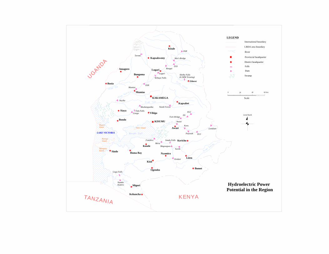
Fig 1: Lake Victoria River Systems and Development Options.

13
Fig 2: Dam Site Project View.