lagrangian sensor systems laboratory
TRANSCRIPT

Applications of Mobile Sensing
Lagrangian Sensor Systems LaboratoryUC Berkeley
Electrical Engineering and Computer Sciences, Syste ms Engineering, Mechanical Engineering, Industrial Eng ineering
and Operations Research
Los Alamos, 03/23/2010
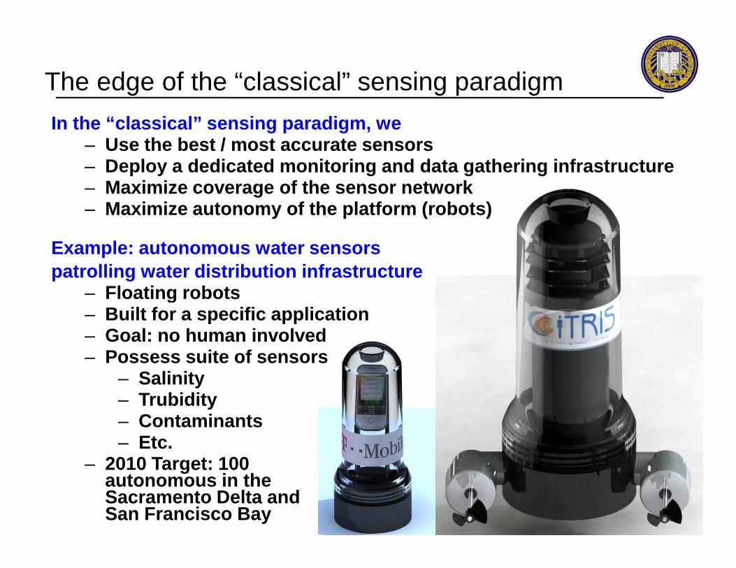
The edge of the “classical” sensing paradigm
In the “classical” sensing paradigm, we– Use the best / most accurate sensors– Deploy a dedicated monitoring and data gathering in frastructure– Maximize coverage of the sensor network– Maximize autonomy of the platform (robots)
Example: autonomous water sensors patrolling water distribution infrastructure
– Floating robots – Floating robots – Built for a specific application– Goal: no human involved– Possess suite of sensors
– Salinity– Trubidity– Contaminants– Etc.
– 2010 Target: 100 autonomous in the Sacramento Delta and San Francisco Bay

User generated content: sensor-free sensing
An example in which user generated content can bemore can be more efficient than the proper tool.
– An appropriate sensor to measure an earthquake is an accelerometer
– USGS has deployed sensor arrays in the US– Today, most smartphones have accelerometers
– Using them for earthquake monitoring is challenging
– Deploying a dedicated infrastructure is – Deploying a dedicated infrastructure is expensive
– Yet Twitter can provide first alert of the type“Did you feel it” based on user generated content

Web 2.0Emergence of the mobile internet
– Internet accesses from mobile devices skyrocketing
– Mobile devices outnumber PCs by 5:1
– 1. 5 million devices/day (Nokia) – Redefining the mobile market:
Google, Apple, Nokia, Microsoft, Intel, IBM, etc.
– Open source computing: – Open source computing: Symbian Foundation, Android, Linux
Sensing and communication suite– GSM, GPRS, WiFi, bluetooth,
infrared– GPS, accelerometer, light sensor,
camera, microphoneSmartphones and Web 2.0
– Context awareness– Sensing based user generated
content
4
0
1 billion
2 billion
3 billion3.3 billion mobile
device subscriptions
worldwide in 2007
[Courtesy J. Shen, Nokia Research Center Palo Alto]
OutlineOutline
Mobile Century traffic experiment
- Issues with mobile sensing in the context of traffic- Mobile Century experiment results
Mobile floating sensor networksMobile floating sensor networks
- Background- Applications
Pollution and noise estimation using smartphones
Conclusion
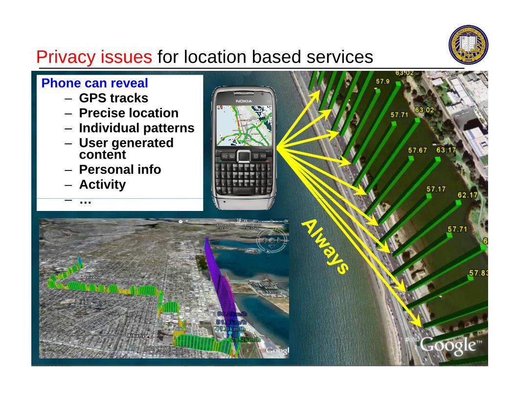
Privacy issues for location based servicesPhone can reveal
– GPS tracks– Precise location– Individual patterns– User generated
content– Personal info– Activity– …– …
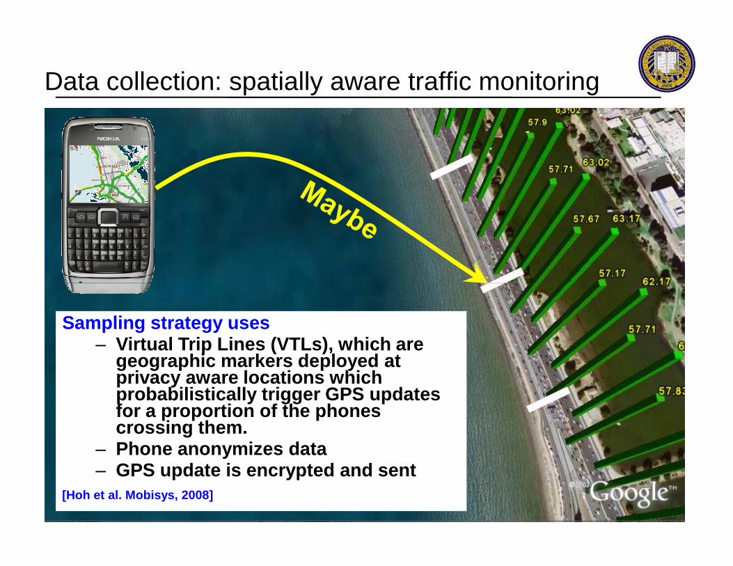
Data collection: spatially aware traffic monitoring
Sampling strategy uses– Virtual Trip Lines (VTLs), which are
geographic markers deployed at privacy aware locations which probabilistically trigger GPS updates for a proportion of the phones crossing them.
– Phone anonymizes data– GPS update is encrypted and sent
[Hoh et al. Mobisys, 2008]

Tradeoffs (summary)Privacy considerations
– Sampling strategy– Randomization of the
sampling– Anonymization of the data– Encryption of the data– Local computations (onboard
the phone)
Accuracy considerations, and data to push the estimation further
– Full trajectory collection– Re-identification (day to day)– Additional context collection
(jam, pictures, other sensors)– Tower information
Hardness of estimation Privacy intrusion
Estimation results– Patterns– Travel time– Aggregate data
Individual trajectories– Inference from patterns– Reconstruction?
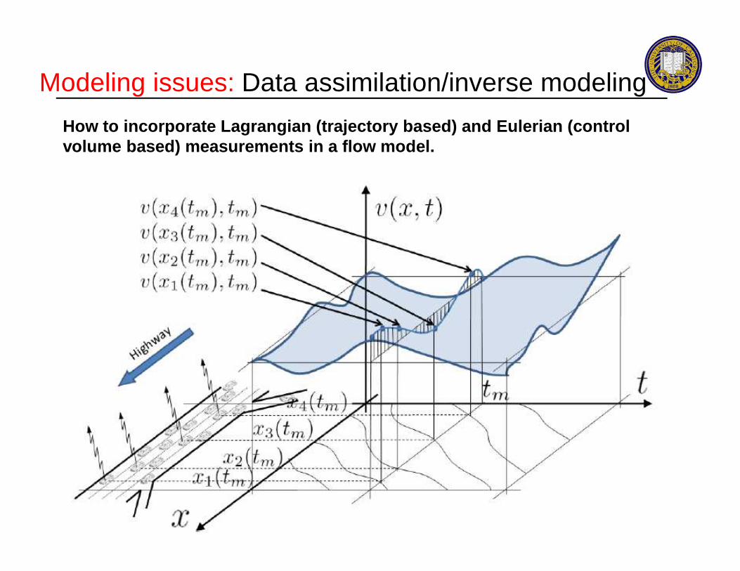
Modeling issues: Data assimilation/inverse modeling
How to incorporate Lagrangian (trajectory based) and Eulerian (control volume based) measurements in a flow model.
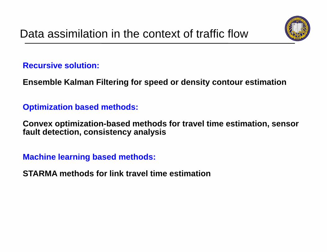
Data assimilation in the context of traffic flow
Recursive solution:
Ensemble Kalman Filtering for speed or density conto ur estimation
Optimization based methods:
Convex optimization -based methods for travel time estimation, sensor Convex optimization -based methods for travel time estimation, sensor fault detection, consistency analysis
Machine learning based methods:
STARMA methods for link travel time estimation

Mobile Century traffic experiment
- Issues with mobile sensing in the context of traffic- Mobile Century experiment results
Mobile floating sensor networks
OutlineOutline
Mobile floating sensor networks
- Background- Applications
Pollution and noise estimation using smartphones
Conclusion
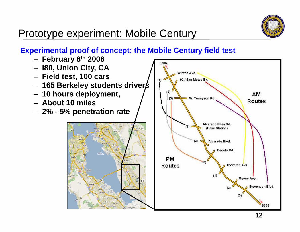
Prototype experiment: Mobile Century
Experimental proof of concept: the Mobile Century field test– February 8 th 2008– I80, Union City, CA– Field test, 100 cars– 165 Berkeley students drivers– 10 hours deployment, – About 10 miles– 2% - 5% penetration rate
12

A glimpse of Mobile Century (February 8th, 2008)
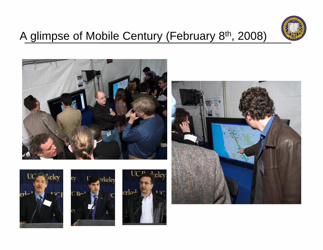
A glimpse of Mobile Century (February 8th, 2008)
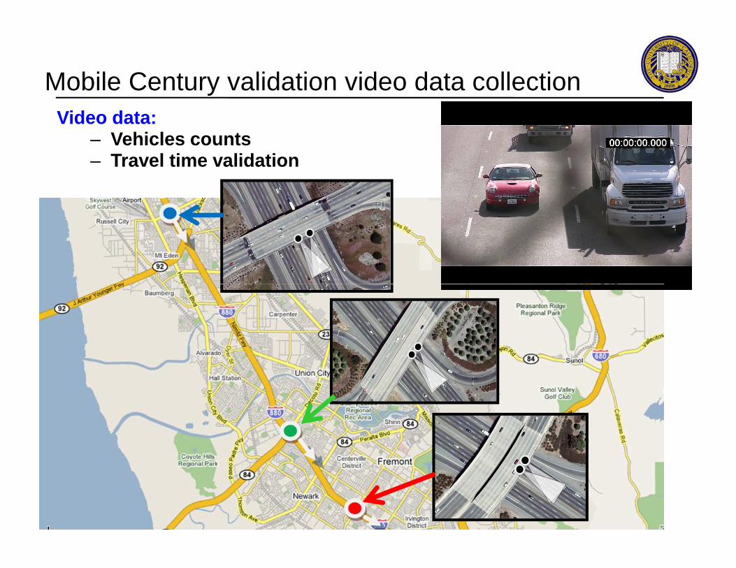
Mobile Century validation video data collectionVideo data:
– Vehicles counts – Travel time validation
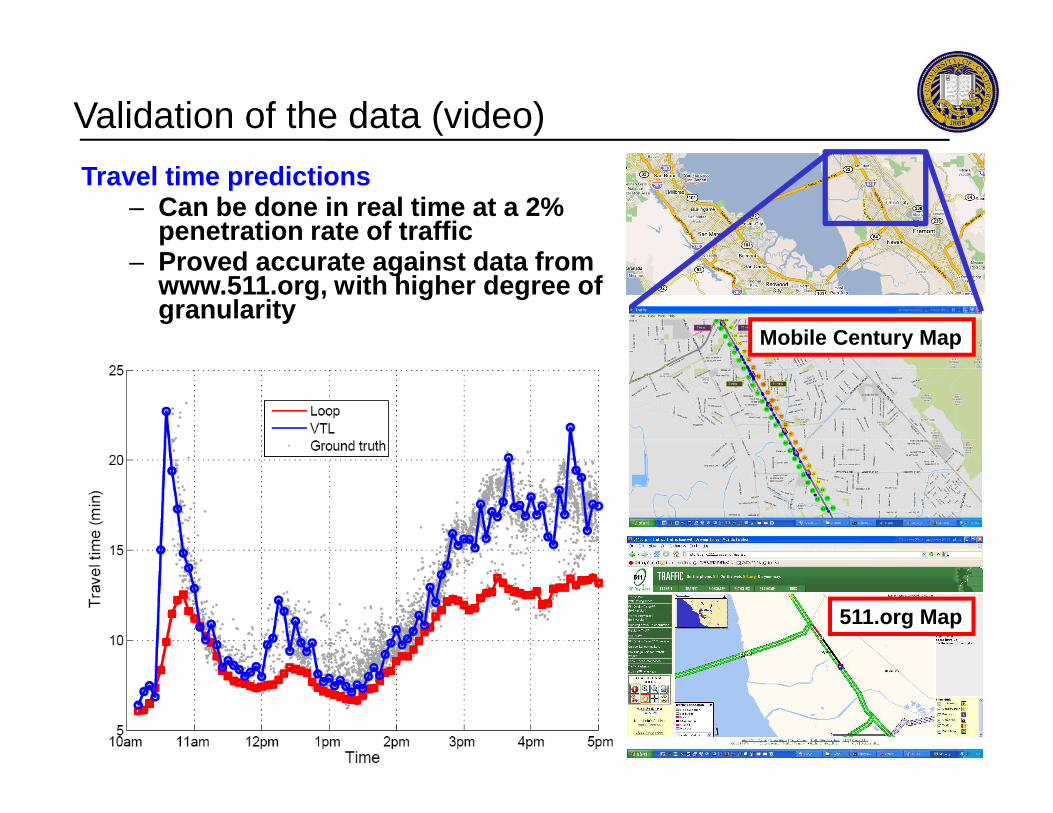
Validation of the data (video)
Travel time predictions – Can be done in real time at a 2%
penetration rate of traffic– Proved accurate against data from
www.511.org, with higher degree of granularity
Mobile Century Map
511.org Map
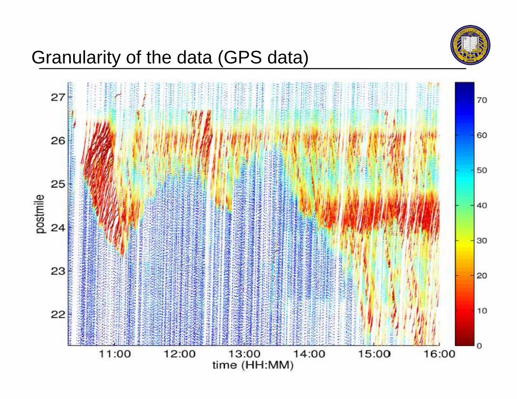
Granularity of the data (GPS data)
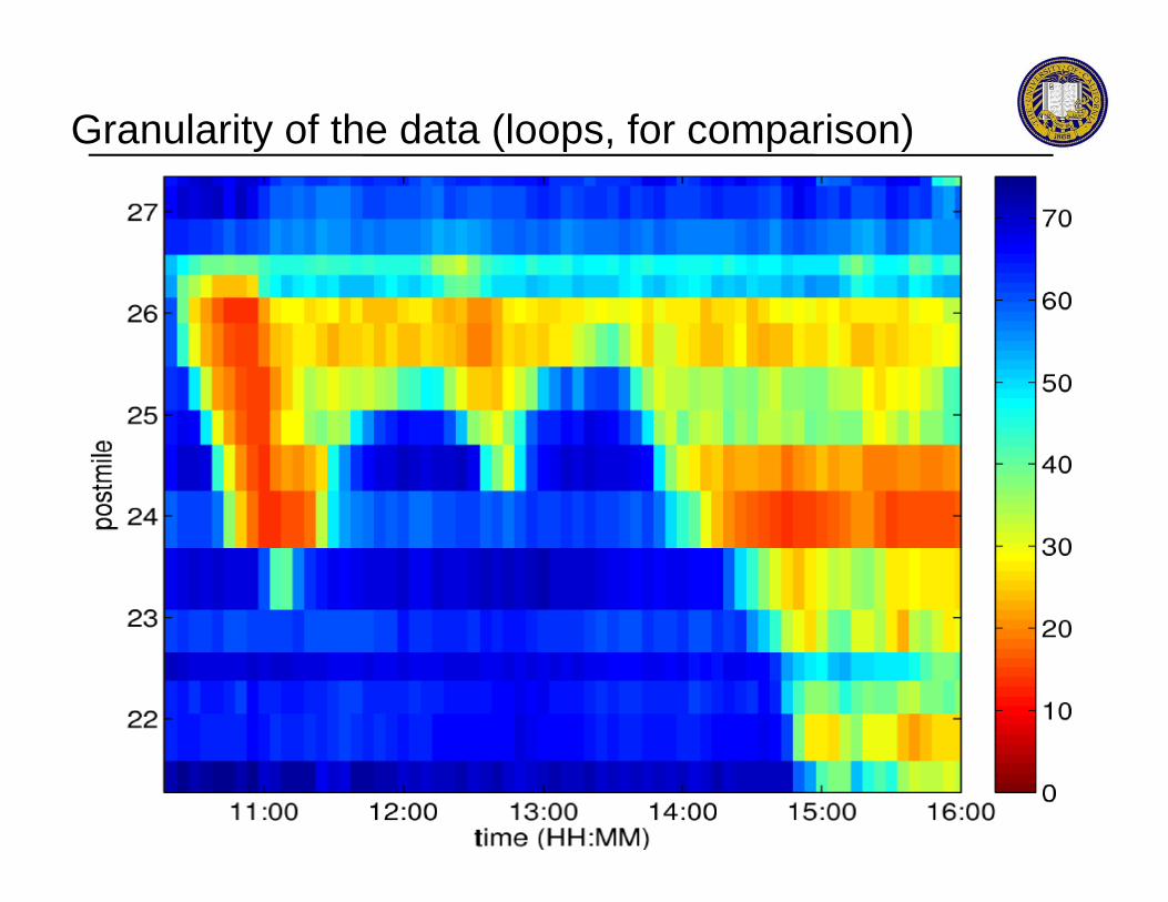
Granularity of the data (loops, for comparison)

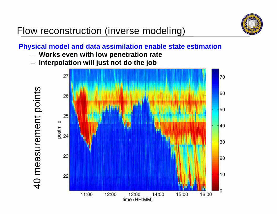
Flow reconstruction (inverse modeling)
Physical model and data assimilation enable state e stimation– Works even with low penetration rate– Interpolation will just not do the job
mea
sure
men
t poi
nts
40m
easu
rem
ent p
oint
s
Flow reconstruction (inverse modeling)
Physical model and data assimilation enable state e stimation– Works even with low penetration rate– Interpolation will just not do the job
mea
sure
men
t poi
nts
40m
easu
rem
ent p
oint
s

Flow reconstruction (inverse modeling)
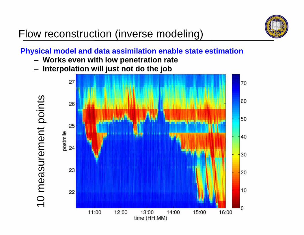
Physical model and data assimilation enable state e stimation– Works even with low penetration rate– Interpolation will just not do the job
10 m
easu
rem
ent p
oint
s10
mea
sure
men
t poi
nts
Flow reconstruction (inverse modeling)
Physical model and data assimilation enable state e stimation– Works even with low penetration rate– Interpolation will just not do the job
10 m
easu
rem
ent p
oint
s10
mea
sure
men
t poi
nts
Pos
tmile
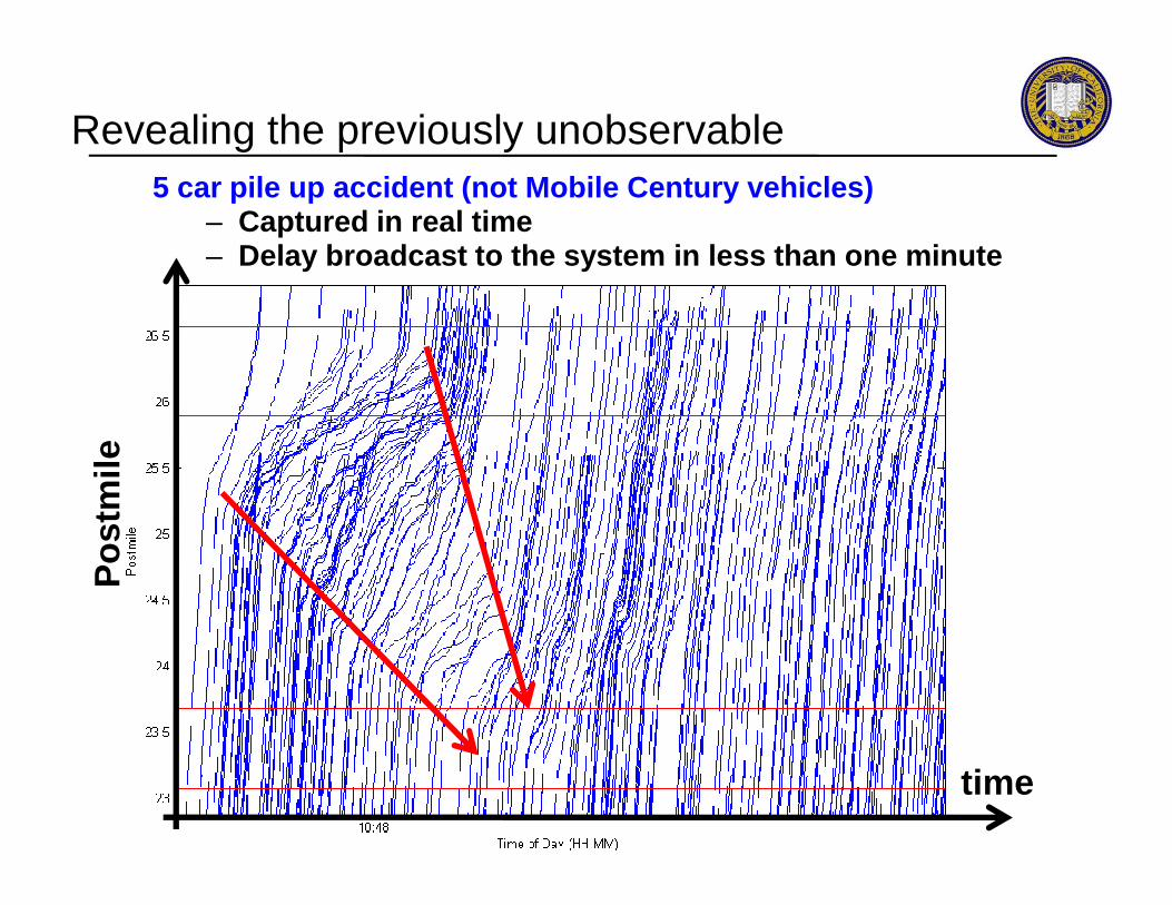
Revealing the previously unobservable5 car pile up accident (not Mobile Century vehicles )
– Captured in real time– Delay broadcast to the system in less than one minu te
Pos
tmile
time
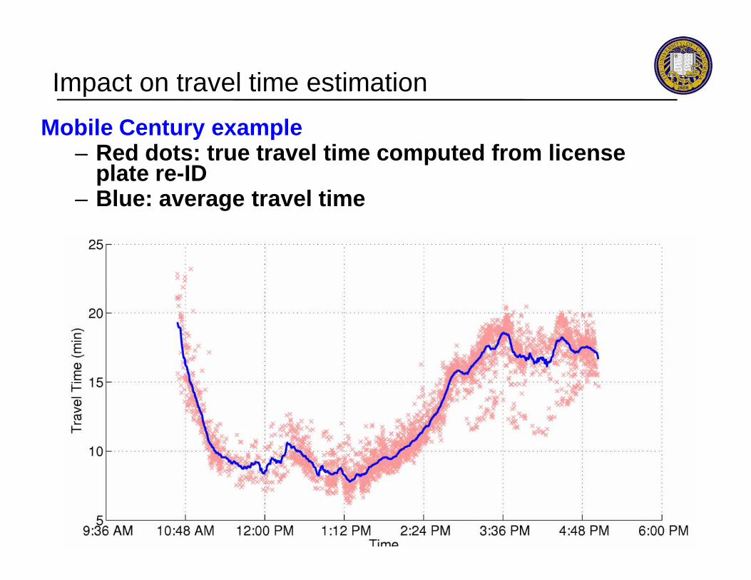
Impact on travel time estimation
Mobile Century example– Red dots: true travel time computed from license
plate re-ID– Blue: average travel time

Impact on travel time estimation
Mobile Century (MC) example (cont’)– Black: average travel time (license plate based)– Red: MC model estimation results (phones only)– Blue: MC model estimation results (PeMS only)
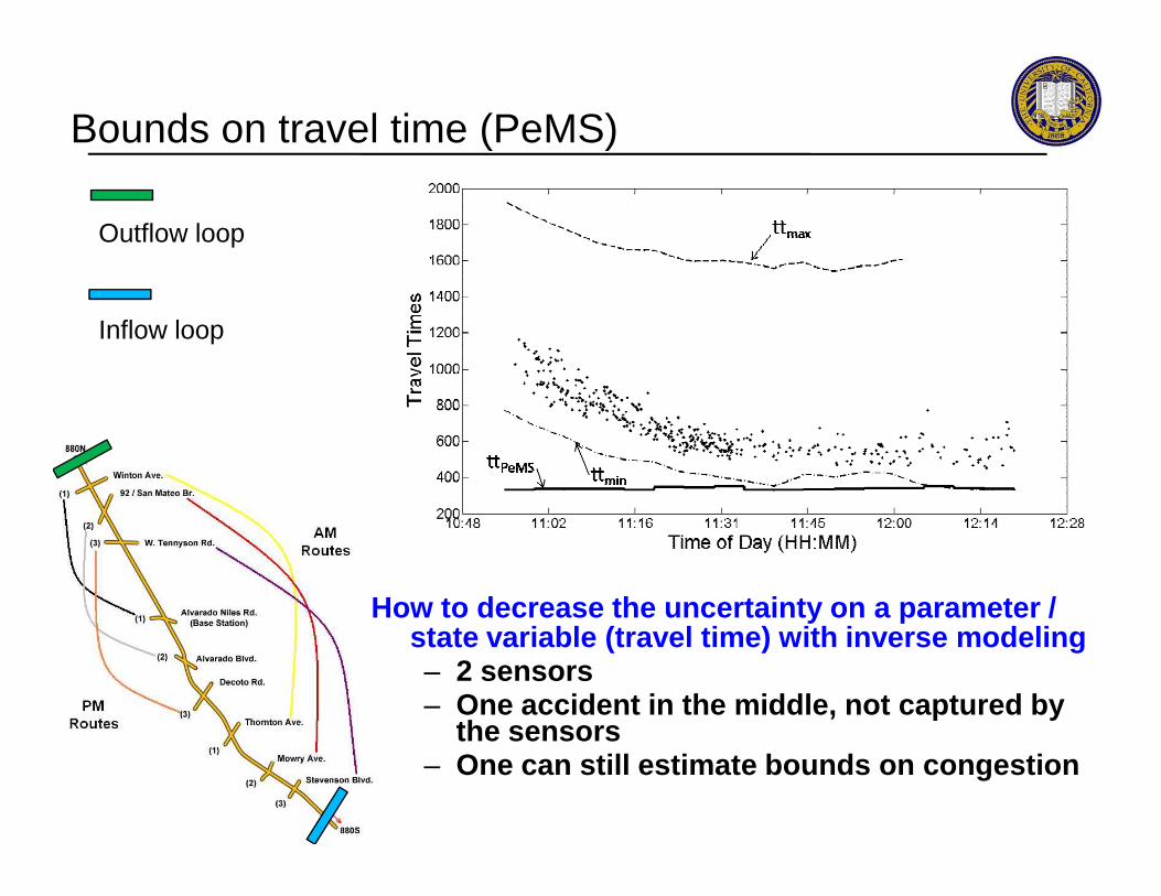
Bounds on travel time (PeMS)
Outflow loop
Inflow loop
How to decrease the uncertainty on a parameter / state variable (travel time) with inverse modeling– 2 sensors– One accident in the middle, not captured by
the sensors– One can still estimate bounds on congestion

Bounds on travel time (PeMS and phones)
Outflow loop
Inflow loop
How to decrease the uncertainty on a parameter / state variable (travel time) with inverse modeling– 2 sensors– One accident in the middle, not captured by
the sensors– One can still estimate bounds on congestion
Mobile Century traffic experiment
- Issues with mobile sensing in the context of traffic- Mobile Century experiment results
Mobile floating sensor networks
OutlineOutline
Mobile floating sensor networks
- Background- Applications
Pollution and noise estimation using smartphones
Conclusion

To Berkeley Data Center via GPRS
Current fleet: 10 passive GPS floats (courtesy M. Stacey), 10 GPS/wireless enabled drifters (manufactured at Berk eley)Target (2010) fleet of 100 (potentially using Android phon es)Potential additional sensors: salinity, temperature, dissolved O 2
Floating [Lagrangian] sensor network
ShortShort--range range wirelesswireless
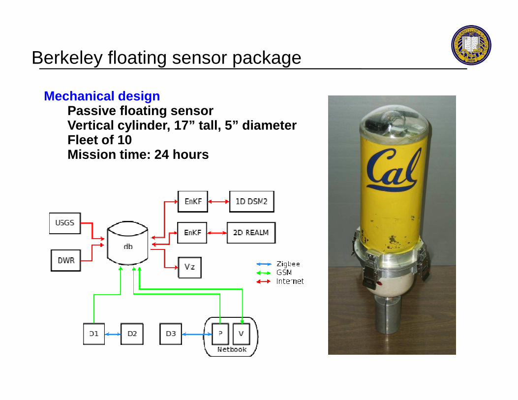
Mechanical designPassive floating sensorVertical cylinder, 17” tall, 5” diameterFleet of 10Mission time: 24 hours
Berkeley floating sensor package

Berkeley floating sensor package
Onboard hardware- Communications: GSM module, ZigBee radio- GPS receiver w/ carrier phase at 1Hz- Temperature/electroconductivitysensor in exposed lower hull- Embedded computer (XScale based PXA270, running Linux)- 200 g LiPo battery, 600 g Pb ballast- 1 GB data storage

Berkeley floating sensor package
Zigbee radio
GSM module
Onboard hardware- Communications: GSM module, ZigBee radio- GPS receiver w/ carrier phase at 1Hz- Temperature/electroconductivitysensor in exposed lower hull- Embedded computer (XScale based PXA270, running Linux)- 200 g LiPo battery, 600 g Pb ballast- 1 GB data storage

Berkeley floating sensor package
Gumstix embedded computer
Battery
Onboard hardware- Communications: GSM module, ZigBee radio- GPS receiver w/ carrier phase at 1Hz- Temperature/electroconductivitysensor in exposed lower hull- Embedded computer (XScale based PXA270, running Linux)- 200 g LiPo battery, 600 g Pb ballast- 1 GB data storage
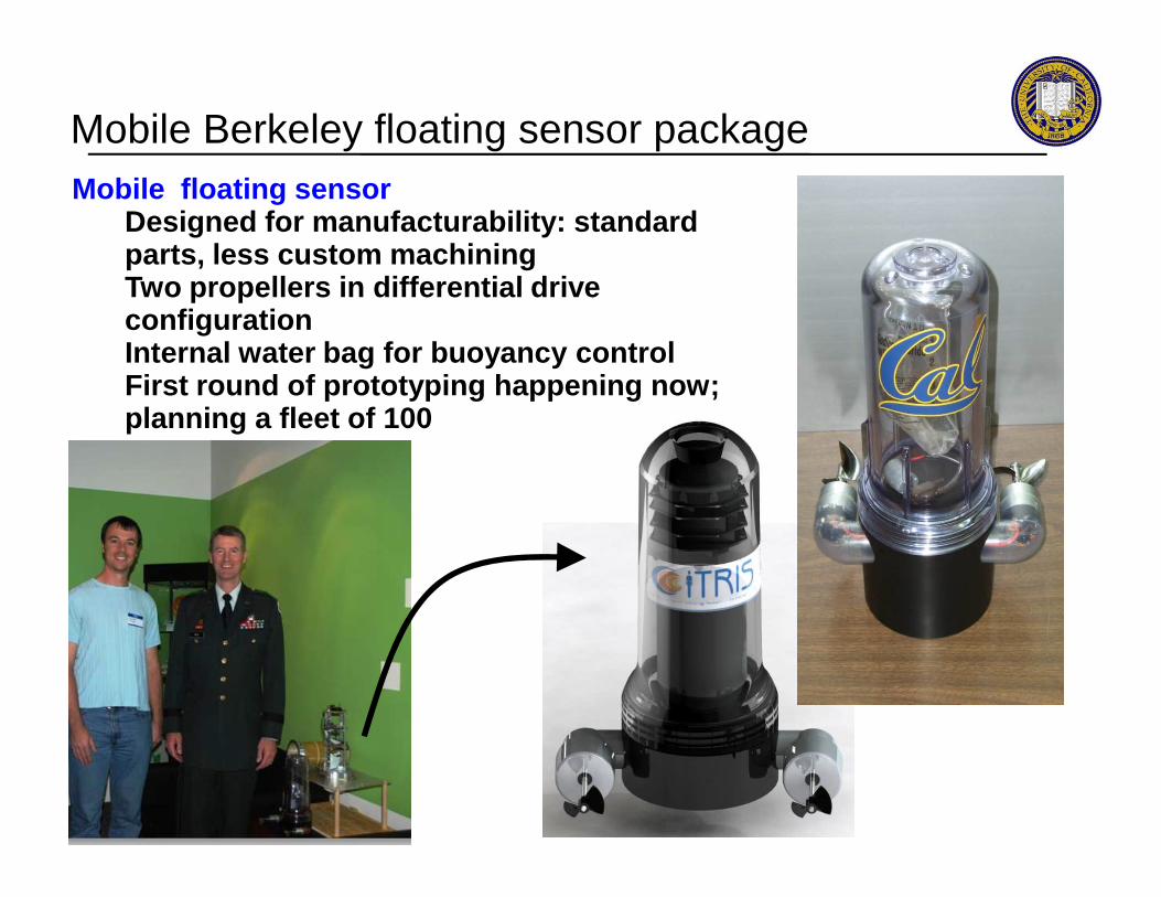
Mobile floating sensorDesigned for manufacturability: standard parts, less custom machiningTwo propellers in differential drive configurationInternal water bag for buoyancy controlFirst round of prototyping happening now; planning a fleet of 100
Mobile Berkeley floating sensor package
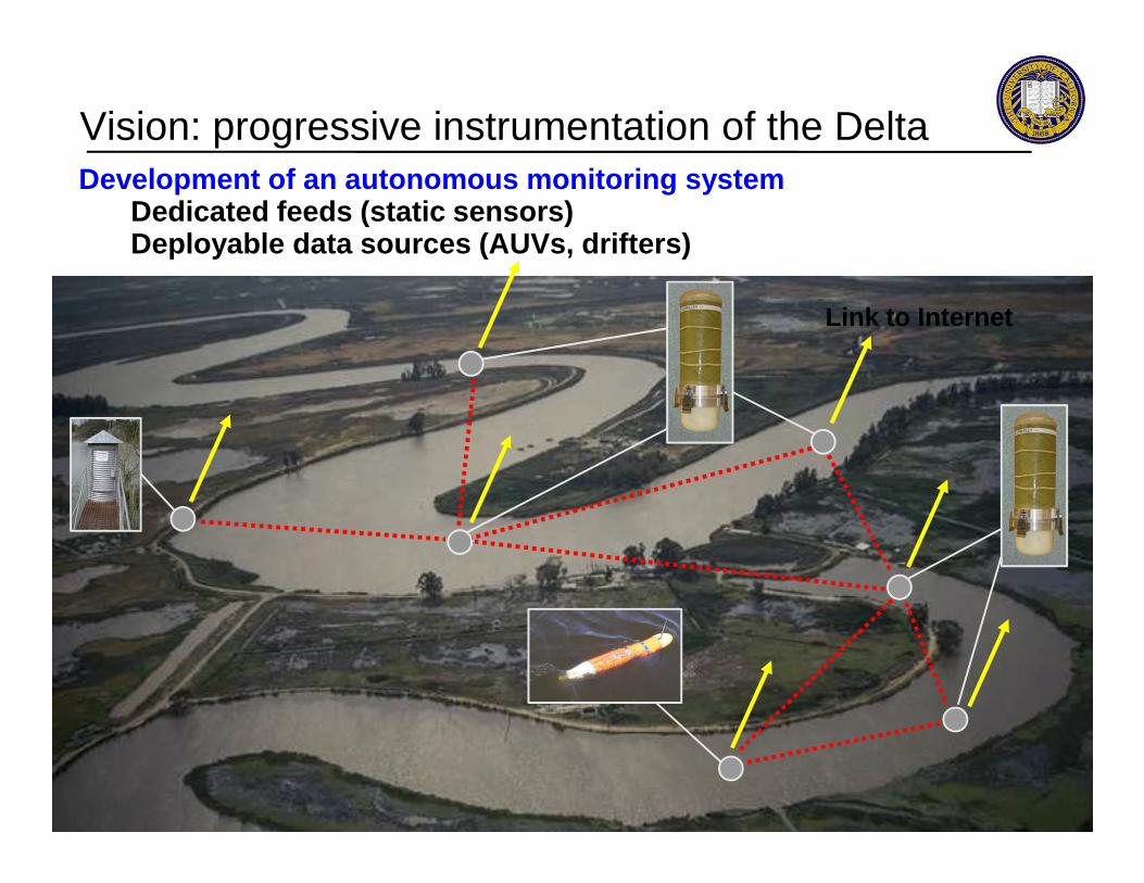
Development of an autonomous monitoring systemDedicated feeds (static sensors)Deployable data sources (AUVs, drifters)
Link to Internet
Vision: progressive instrumentation of the Delta
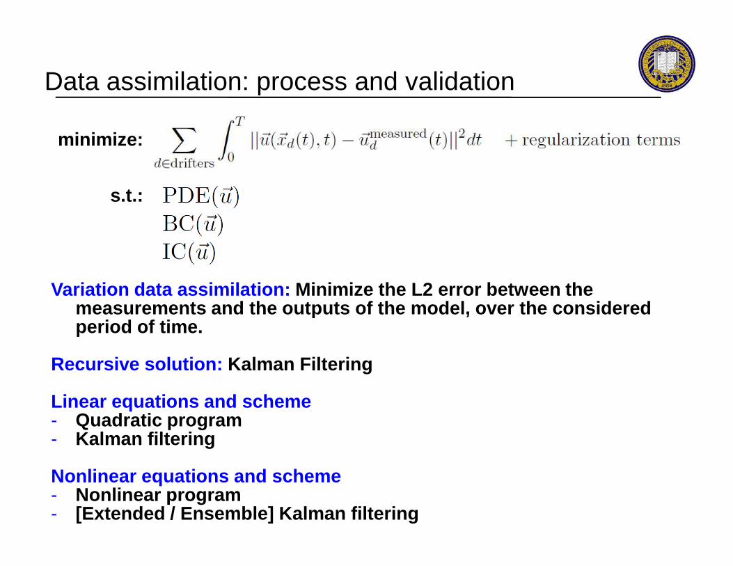
Data assimilation: process and validation
minimize:
s.t.:
Variation data assimilation: Minimize the L 2 error between the Variation data assimilation: Minimize the L 2 error between the measurements and the outputs of the model, over the considered period of time.
Recursive solution: Kalman Filtering
Linear equations and scheme- Quadratic program- Kalman filtering
Nonlinear equations and scheme- Nonlinear program- [Extended / Ensemble] Kalman filtering
Mobile Century traffic experiment
- Issues with mobile sensing in the context of traffic- Mobile Century experiment results
Mobile floating sensor networks
OutlineOutline
Mobile floating sensor networks
- Background- Applications
Pollution and noise estimation using smartphones
Conclusion

June 2, 2004June 2, 2004 June June 55, , 20042004
Response to unanticipated events could be improved using mobile sensing, for example in the case of:- Heavy Rains, floods- Contaminant Spills- Levee Failures
2004 Jones Tract Levee Failure-- Silt from flooded area
Response to unanticipated events
June 2, 2004June 2, 2004 June June 55, , 20042004-- Silt from flooded area -contaminated the Delta-- South pumps shut down -until contaminant cleared-- Fixed network insufficient-to determine safe startup- $1M/day, 3 day shutdown
Questions:-- Where does the water go?-- How to recalibrate the -Hydrodynamics?

US Army Corps of Engineers / HSARPA demonstration: Rapid Repair of Levee Breach- Rapid Repair of Levee Breach using water-filled fa bric tubes- Controlled levee breach with 125 cubic feet/s flow
RRLB test at Stillwater, Oklahoma

RRLB test at Stillwater, Oklahoma
US Army Corps of Engineers / HSARPA demonstration: Rapid Repair of Levee Breach- Side experiment using supply canal- 1200' long, sinuous path- Trapezoidal prismatic canal- Vegetated bottom and sides- Upstream BC: 50 cubic feet/s- Downstream BC: height controlled by gate- Downstream BC: height controlled by gate- 20 runs, 6 drifters deployed upstream; gate modifi ed in 50% of runs

Mobile Century traffic experiment
- Issues with mobile sensing in the context of traffic- Mobile Century experiment results
Mobile floating sensor networks
OutlineOutline
Mobile floating sensor networks
- Background- Applications
Pollution and noise estimation using smartphones
Conclusion
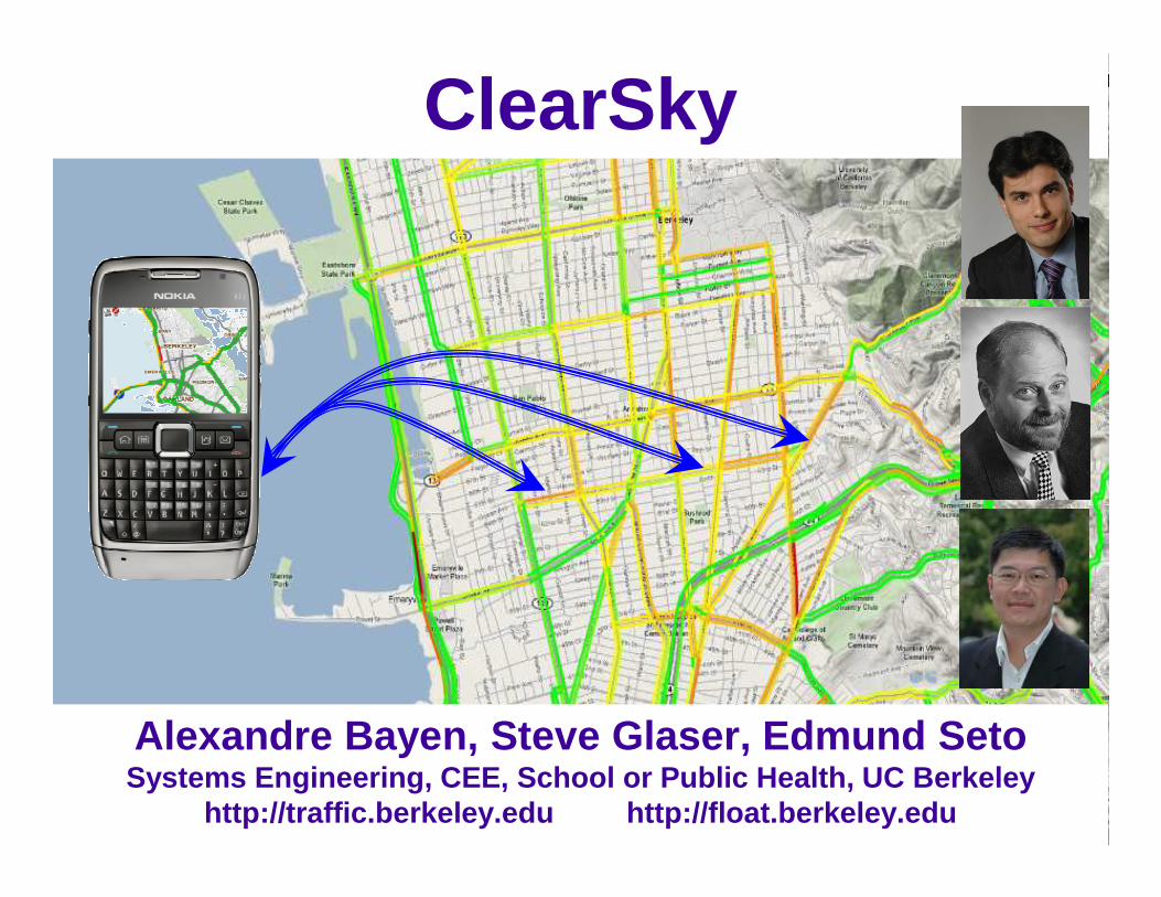
ClearSky
Alexandre Bayen , Steve Glaser, Edmund SetoSystems Engineering, CEE, School or Public Health, UC Berkeley
http://traffic.berkeley.edu http://float.berkeley.ed u
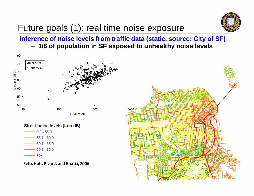
Future goals (1): real time noise exposureInference of noise levels from traffic data (static , source: City of SF)
– 1/6 of population in SF exposed to unhealthy noise levels
Seto, Holt, Rivard, and Bhatia, 2006
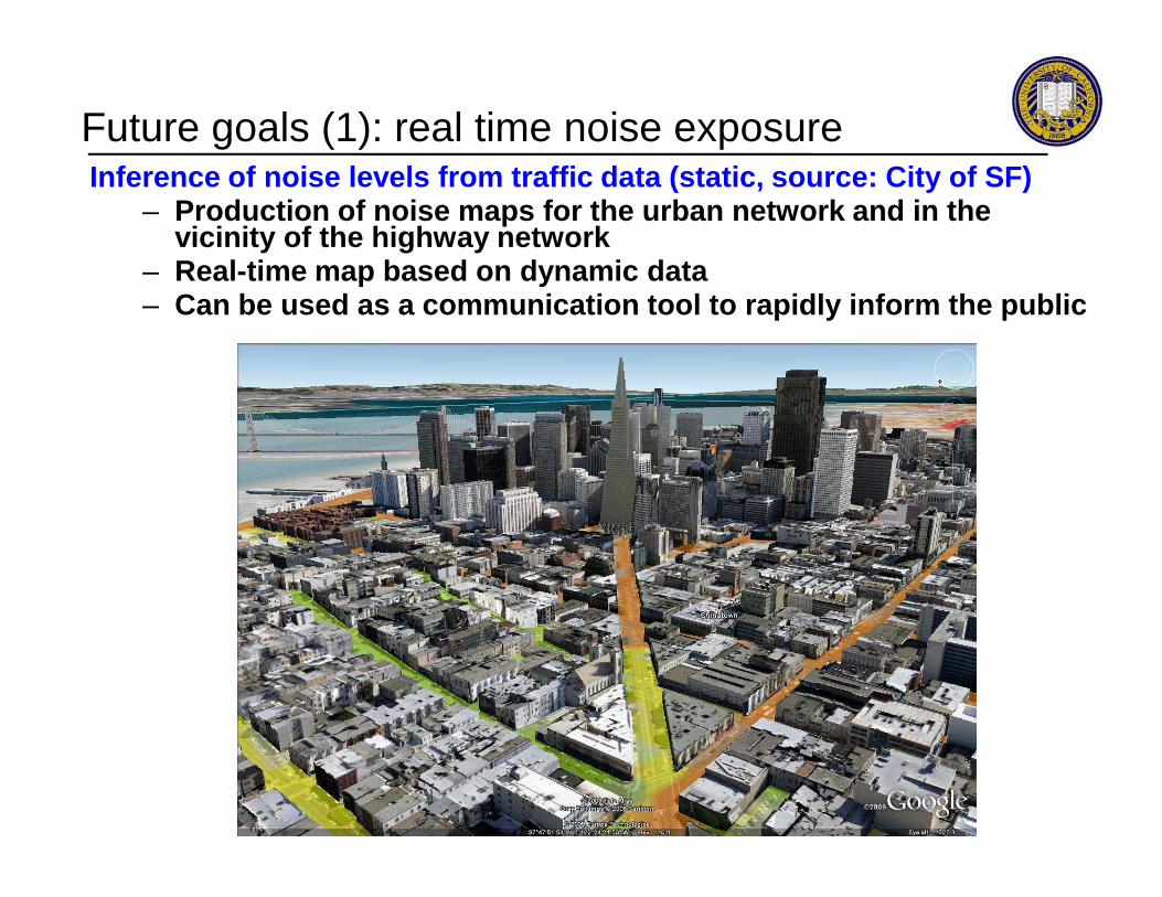
Future goals (1): real time noise exposureInference of noise levels from traffic data (static , source: City of SF)
– Production of noise maps for the urban network and in the vicinity of the highway network
– Real-time map based on dynamic data– Can be used as a communication tool to rapidly info rm the public
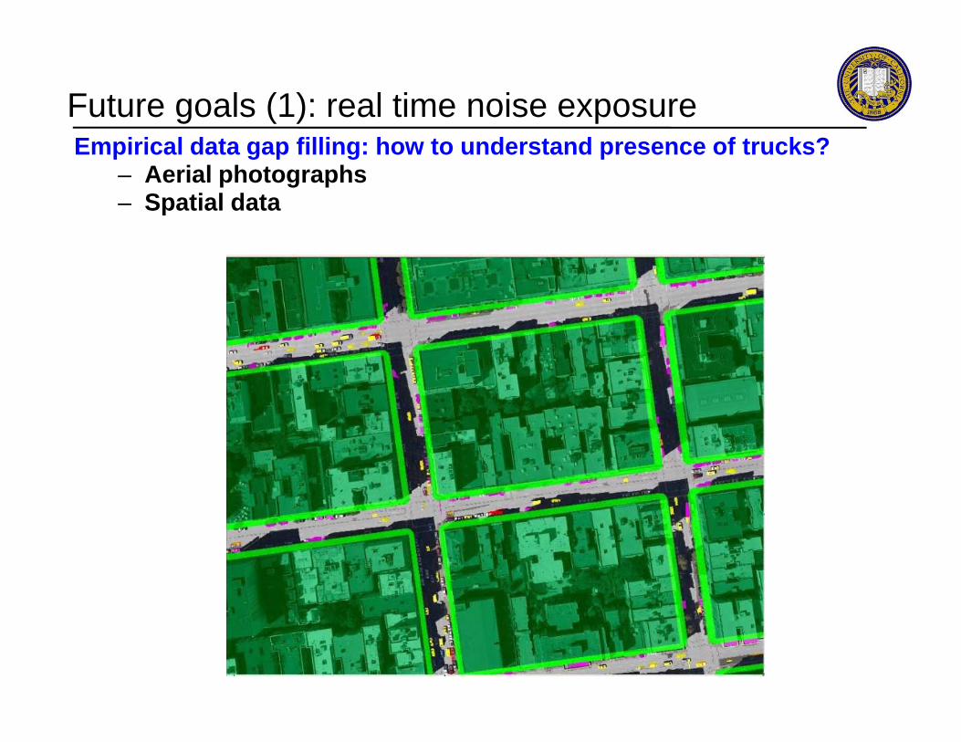
Empirical data gap filling: how to understand prese nce of trucks?– Aerial photographs– Spatial data
Future goals (1): real time noise exposure
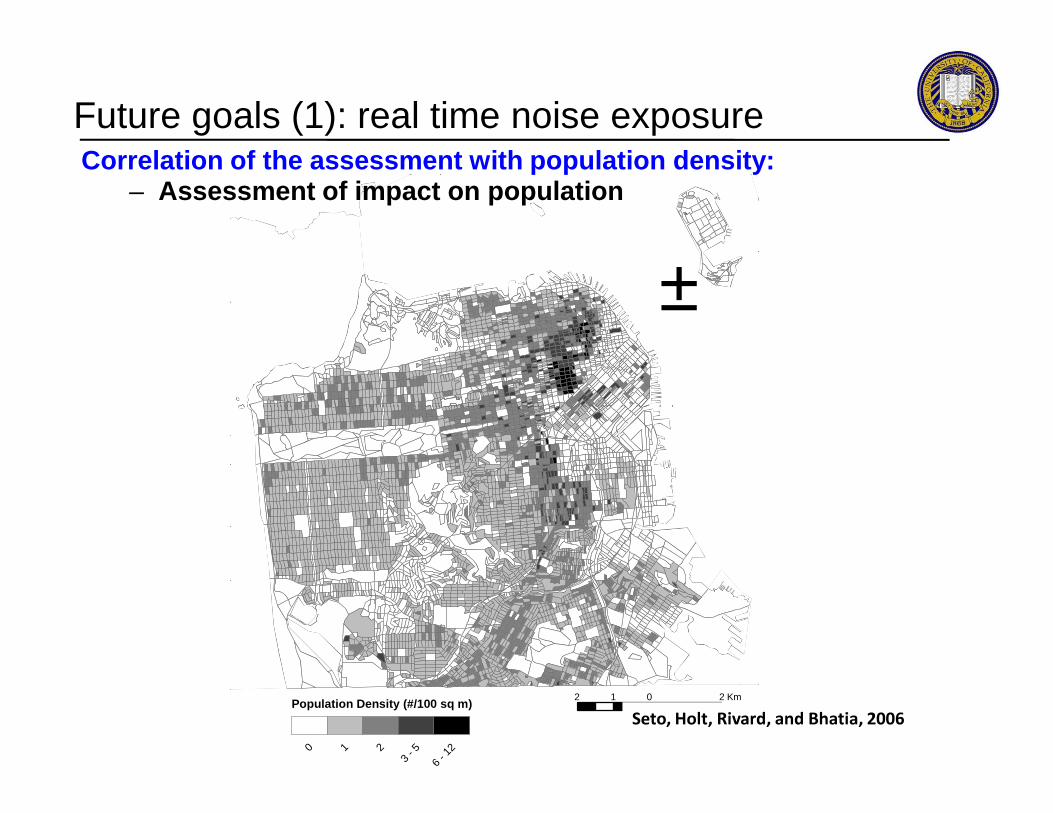
±
Correlation of the assessment with population densi ty:– Assessment of impact on population
Future goals (1): real time noise exposure
2 0 21 Km
Population Density (#/100 sq m)
0 1 2
3 - 5
6 - 1
2
Seto, Holt, Rivard, and Bhatia, 2006

Impact maps on the population: building / using ris k curves– Mortality rates can be inferred from these maps (ot her agents)– In a security scenario: one hour death maps, two ho urs, etc.
Future goals (1): real time noise exposure

Integration process (noise, air pollution, airborne agent, etc.)– Process will be integrated entirely in Mobile Mille nnium system– Linked to population data to assess impact on popul ation
Traffic Counts Citywide Traffic Map
Future goals (1): real time noise exposure
Traffic-NoiserelationshipCitywide Noise Map
Noise-Annoyance relationship Citywide Population Map
Citywide Annoyance Map
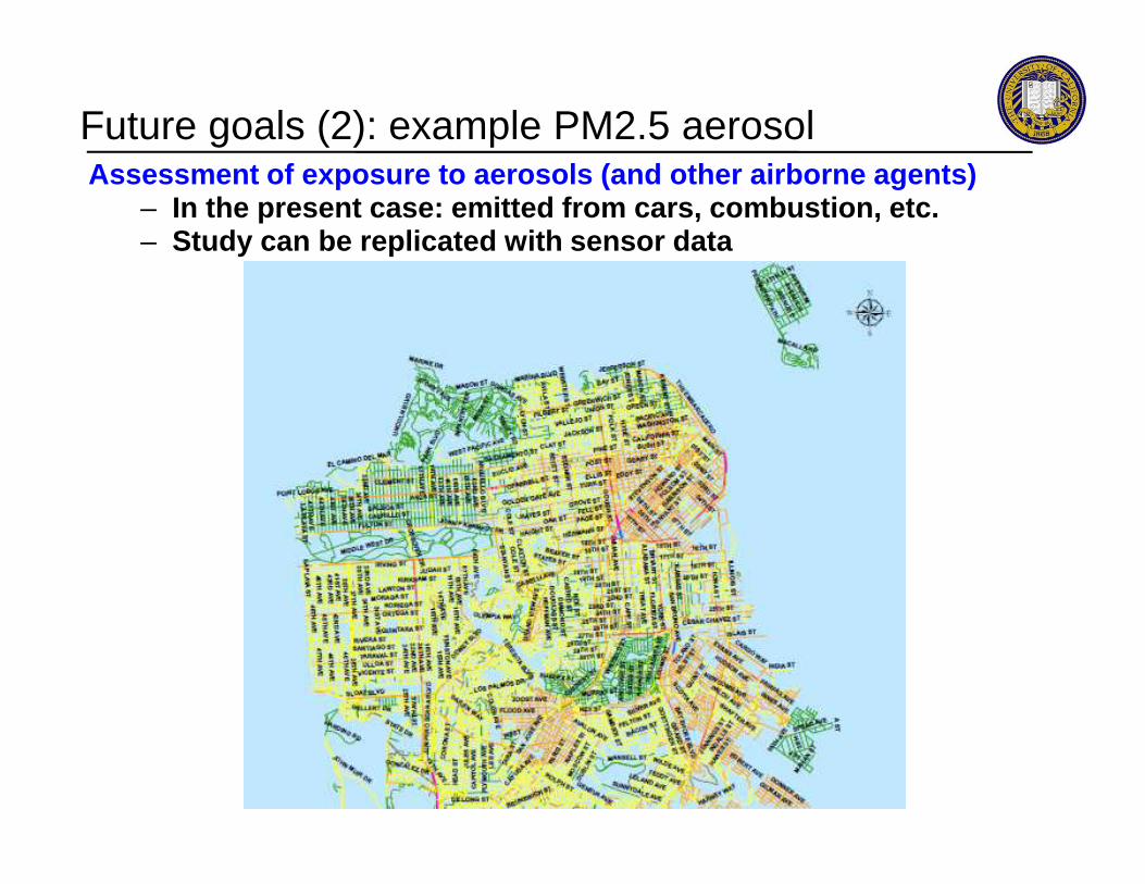
Assessment of exposure to aerosols (and other airbo rne agents)– In the present case: emitted from cars, combustion, etc.– Study can be replicated with sensor data
Future goals (2): example PM2.5 aerosol
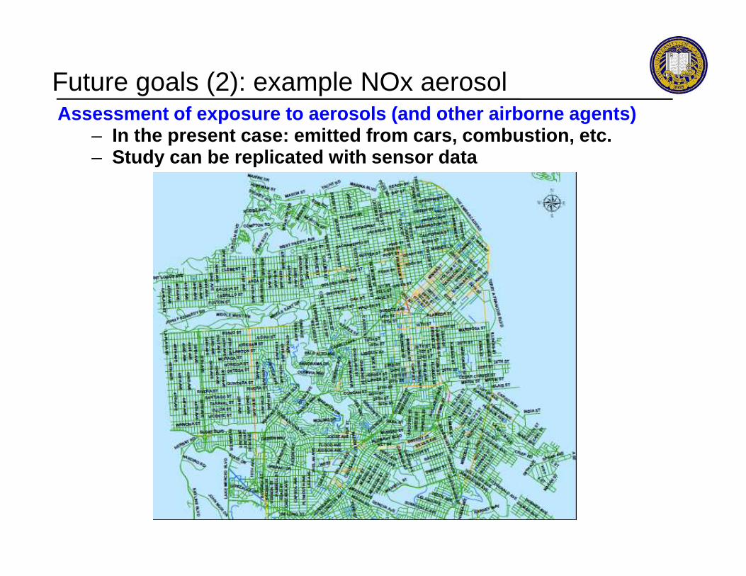
Assessment of exposure to aerosols (and other airbo rne agents)– In the present case: emitted from cars, combustion, etc.– Study can be replicated with sensor data
Future goals (2): example NOx aerosol

Scientific approach– Validation of the models (in the present case: Gaus sian
dispersion models)– Model, assess concentration, measure, check that th e
measured data corresponds to the estimate– Photographs: deployment of validation sensors.
Validation procedure

Scientific approach– Validation of the models (in the present case: Gaus sian
dispersion models)– Model, assess concentration, measure, check that th e
measured data corresponds to the estimate– Photographs: deployment of validation sensors.
Validation procedure
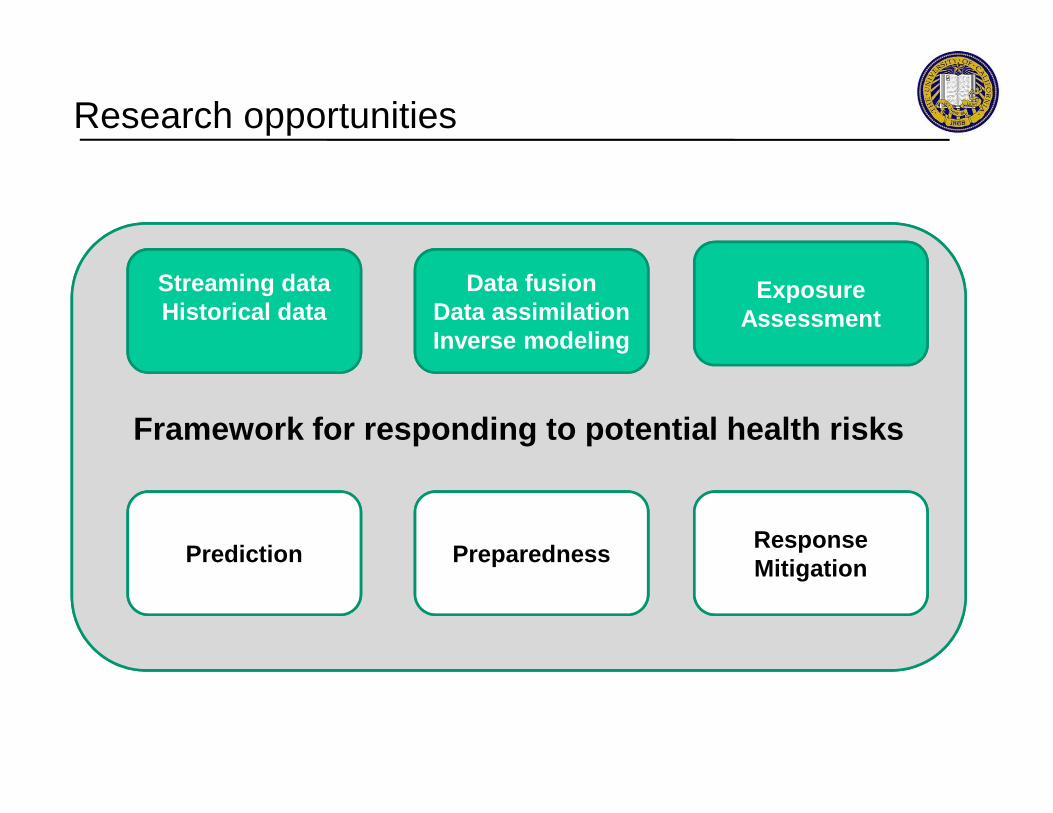
Research opportunities
Exposure Assessment
Streaming data Historical data
Data fusionData assimilationInverse modeling
Framework for responding to potential health risks
ResponseMitigation
Prediction Preparedness
Outline
Mobile Century traffic experiment
- Issues with mobile sensing in the context of traffic- Mobile Century experiment results
Mobile floating sensor networks
Outline
Mobile floating sensor networks
- Background- Applications
Pollution and noise estimation using smartphones
Conclusion
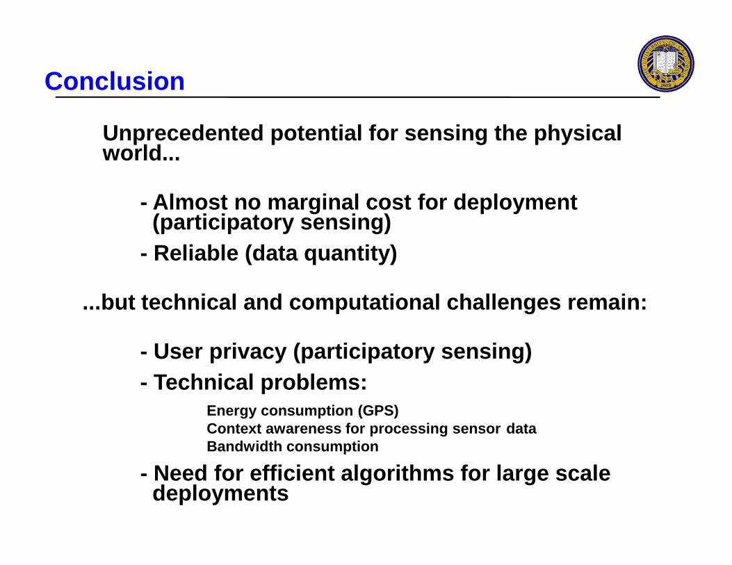
Conclusion
Unprecedented potential for sensing the physical world...
- Almost no marginal cost for deployment (participatory sensing)
- Reliable (data quantity)
...but technical and computational challenges remai n:
- User privacy (participatory sensing)- Technical problems:
Energy consumption (GPS)Context awareness for processing sensor dataBandwidth consumption
- Need for efficient algorithms for large scale deployments