labrant-lindsey lane neighborhood plan …lindsey lane on the north side and labrant to the south...
TRANSCRIPT

LABRANT-LINDSEY LANE
NEIGHBORHOOD PLAN
AND
DEVELOPMENT CODE
LABRANT-LINDSEY LANE NEIGHBORHOOD PLAN
An amendment to the Flathead County Master Plan
Adopted by the Flathead County Board of Commissioners Resolution No. 1323A
April 7, 1998
LABRANT-LINDSEY LANE ZONING DISTRICT Resolution No. 1345A
Adopted October 6, 1998
DEVELOPMENT STANDARDS Resolution No. 955AX
Adopted October 6, 1998

1
THE LABRANT-LINDSEY LANE NEIGHBORHOOD PLAN
INTRODUCTION:
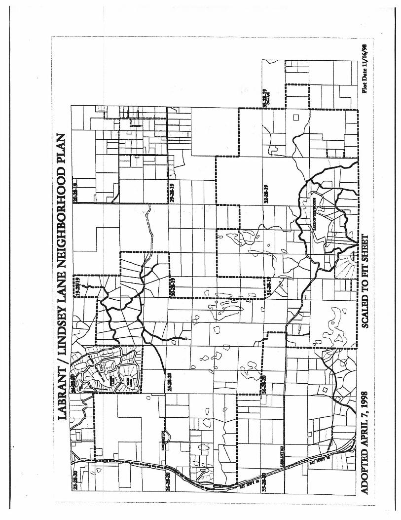
THE LABRANT-LINDSEY LANE NEIGHBORHOOD: The LaBrant-Lindsey Lane Neighborhood generally encompasses those areas that are served by LaBrant Road and Lindsey Lane. The area lies north of Echo Lake, south of Many Lakes and on the east side of Hwy 35. (Please see Figure 1)
WHY A NEIGHBORHOOD PLAN: The LaBrant-Lindsey Lane Neighborhood lies within the jurisdiction of the Flathead County Master Plan, yet the County Master Plan does not give specific guidance or direction for the LaBrant-Lindsey Lane area. There is a strong desire to protect the amenities and rural character of this neighborhood through a land development code as evidenced by the 1996 survey results showing 81% of the respondents calling for land use standards that affect the rate, amount or type of development in the area. Yet there is no plan to give specific guidance as to how such regulations should be crafted and what they should address. This Neighborhood Plan is intended to bridge the gap and offer specific direction and guidance for this area.
Generally, there are no specific land development codes in effect in this area. State and County Health Department regulations do require sanitation approval for all land divisions less than 20 acres in size. County Subdivision Regulations apply to all land splits less than 160 acres in size but a substantial number of lots are still created using exemptions to the subdivision laws and thus receive no formal subdivision review. The Lakeshore Protection Program applies to all lakes over 20 acres in size but in this neighborhood only Lake of the Woods qualifies, the smaller pothole lakes are exempt. In summary, current plans and regulations on the books are not specific enough to meet the needs of this neighborhood and at the same time protect its rural character. The neighborhood planning process is intended to give guidance in meeting the specific needs of this neighborhood.
DEVELOPMENT OF THE PLAN: The LaBrant-Lindsey Lane Neighborhood Plan was developed by the property owners in the LaBrant-Lindsey Lane Neighborhood. Due to neighborhood concerns about the potential for increased subdivision activity on a much larger scale than has been experienced in the past and the concern that there was no neighborhood input into such things as large scale commercial development and gravel extraction, the property owners in the LaBrant-Lindsey Lane Neighborhood came together to provide advice to elected and appointed government officials, developers, and existing and future property owners. Through a series of meetings they studied the issues that would be affected by increased growth pressures such as police and fire protection, road maintenance and the likelihood of major improvements, schools, water quality and wildlife. The neighborhood identified likes and dislikes and discussed future aspirations for their area. Finally, they identified goals (what the community wants to become), developed and discussed alternatives for achieving these goals, and selected courses of action.
The development of this plan had its beginnings in early 1996. A group of property owners from the LaBrant-Lindsey Lane area met to talk about common concerns following the hearing process for a large residential subdivision. They decided to send a newsletter and survey to all property owners in the surrounding area to gage interest in developing a neighborhood planning process and determine neighborhood views. The original survey included LaBrant-Lindsey Land but also included Many Lakes and the Foothills Road area as well. At the first meeting, held in Creston in the spring of 1996, participants decided to undertake a series of informational meetings to help better understand the neighborhood. It was agreed that after these meetings, the people within each neighborhood would decide whether or not they wanted to proceed with a planning effort. In all, 6 meetings were held. Speakers were invited from the County Road Department and the Sheriff’s Department, Montana
2
Department of Fish, Wildlife and Parks, the local school district and the Creston Fire Department. In addition, a local geologist and a hydrologist were invited. In December 1996 the group was polled to determine if the planning process should proceed. There appeared to be strong support for continuing with the Neighborhood Plan and some type of a land development code for the LaBrant Area beginning approximately one mile east of Highway 35 and for the Lindsey Lane area to the north. Residents in both the Many Lakes and Foothills area showed much less support and those areas were dropped from the process. During the next 6 months, many people within the neighborhood were contacted on a one-to-one basis and a second newsletter was sent out in June, 1997 updating the neighborhood of progress over the last year. Based on the past year’s input, a plan was drafted and the plan and survey were mailed to each property owner in the proposed neighborhood in November, 1997. The results of the survey indicated (to be filled in when the survey is tabulated)
THE RESOURCES:
Prior to development of a Neighborhood Plan, residents felt that they should become more informed about their neighborhood. They wanted to know what the effects of development would have on such things as water quality, particularly ground water.
They also felt wildlife issues and availability of public services such as roads, schools and fire protection were key to the future of their neighborhood. Following is a discussion of those issues.
GROUND WATER AND GEOLOGY
In the process of developing this plan Roger Noble, Hydrologist and Lex Blood, Geologist were both contacted. They concurred that there is a lack of good data on ground water in this area. Geologically, this area was formed by glacier action and contains to a great degree glacier deposits of cobble, boulders and silts laid down in a very erratic pattern. Pothole lakes are a common feature and are merely depressions in sand deposits laying over silts and clay filled with ground. Consequently, the level of these lakes directly reflects the local ground water level. In wet years the lakes will be high and conversely in dry years theses lakes will be low or dry.
There are two primary aquifers in this area. The shallow ground water aquifer and the deep aquifer. The shallow aquifer is the primary source of all shallow wells. This aquifer is highly inter-connected with surface water. It is not uncommon for runoff and streams such as Brown to literally disappear into the gravels and flow as a shallow aquifer. The water level in the lakes merely reflects the level of ground water. Because this aquifer is so inter-connected, it is also highly vulnerable to contamination. In addition, this aquifer is fast moving, generally traveling east to west. Any source of contamination could have wide spread consequences. It is very important to anticipate and monitor land use activity up hill because of the great potential for down gradient impacts.
The deep aquifer is pristine in quality and lies 600-800 feet deep. It has substantial volumes, is used by major irrigators and the Creston Fish Hatchery and is not subject to the effects of draw down to date. It is separated from the shallow aquifer by bedrock. In summary, ample ground water exists, however the shallow aquifer is highly subject to contamination because of local disturbances or actions including the impacts of future development. A contaminant source in one area may have widespread effects throughout the neighborhood.

3
COUNTY ROAD SERVICES
Charles Johnson, Flathead County Road Department, was contacted concerning County road issues, primarily LaBrant road. He said his staff is the same size as it was in 1989 yet population has increased by 10,000 people and traffic on County roads has grown 20%. He pointed out that the rural home that pays $1,000 in property tax pays only $32 dollars of this to the road department. Today, each one of his road crews is responsible for maintaining approximately 44 miles of roadway which makes regular maintenance extremely difficult. He stated that construction costs keep increasing. In the last 6 years asphalt has gone up 150%. The County presently has a moratorium on new paving of County roads and is trying its best to maintain/rebuild existing paved roads. The County does not dust proof its gravel roads. If private parties want to do this, the County will, if possible, grade the applicants road in preparation for dust coating but the owners are responsible for maintenance and pothole filling after the application. A major problem with County roads is that most of the old roads were built to a minimal standard and are very costly to maintain. As an example, Fish Hatchery Road was a log corduroy road (logs laid over muck covered with dirt and gravel, then paved). They were never intended for long service or heavy traffic.
Future concerns include lack of a County paving program for existing County gravel roads, limited maintenance of existing County roads, a need for better standards for private driveway encroachments onto County roads for drainage and access, and the concern that typical rural residential development does not pay, in tax dollars, its share of impacts on the County road system. Lindsey Lane is a private road. Maintenance is the responsibility of the abutting property owners. Traffic and wear on the road continues to increase as development continues. Lindsey Lane on the north side and LaBrant to the south are the primary County roads within this neighborhood. Both are graveled. There are no scheduled major improvements of any type including widening or paving in the near future. In stating this, Mr. Johnson acknowledged that LaBrant Road was in serious condition carrying traffic it was not designed for. In particular, LaBrant contains site distance limitations, below standard curves, inadequate right-of-way, unfavorable dust conditions in the summer and snow plowing problems in the winter, width problems, a deteriorated travel surface and no provision for pedestrians even though school children use the road on a regular basis.
SCHOOLS
The LaBrant Lindsey Lane neighborhood straddles 3 rural school districts, Creston, Bigfork and Cayuse Prairie. John Babcock, principal of Cayuse Prairie School, gave a brief overview of rural schools in the area. He stated the East Valley was growing slower than other parts of the County. However, capacity was becoming an issue everywhere. He noted that Cayuse Prairie School in particular had room for growth but this could change quickly. He said that there is increased talk among the East Valley schools of the need to construct a common middle school for grades 7 – 8. On the other hand, he stated that there is no consensus on this and no money, just a need. The State provides funds for education but it does not provide building funds associated with an increased student body and therein lies a conflict. While increased student loads bring in an increase in State funding, there is usually a year’s lag time in funding and the funding only meets the educational needs, it does not pay for building expansion.
Creston enrollment for 1996-97 was 92 students for grades K-6th. This is an 84% increase over the past 10 years, when enrollment stood at 50. Creston operates a 5 room school that can accommodate some limited growth in the District. Creston transfers 7th and 8th grades into Kalispell (District 5) at the cost of just over $1400 per student per year, as it has no room for these students. Bigfork enrollment for 1996-97 was 579 students in grades K-8th. This is a 19% increase over the past 10 years, when enrollment stood at 488. This school is also very near capacity.

4
Cayuse Prairie enrollment for 1996-97 was 239 students for grades K-8th. This is only a 1% increase over the past 10 years, when enrollment stood at 237. The district has recently gone through a building expansion and can accommodate additional growth in students.
FIRE PROTECTION
Gary Mahugh, Creston Fire Chief, was contacted concerning fire protection issues in the neighborhood. He said he has seen much change. The department has 50 – 100 responses per year. Chimney fires used to be big, now it is structure fires and vehicle accidents. They have 28 volunteers on staff. In the past, it was almost all farm community members, today only 2 are from the farm community. This creates a response problem during the day as volunteers who historically worked in the neighborhood during the day, are now in town at work and often unable to respond. Costs of operation continue to climb with an average fire truck costing $200,000 and safety equipment at $2,000 per fire fighter. They maintain 4 stations with the main one in Creston.
He stated that there are several issues in this neighborhood that impact his Department. There is a general lack of adequate water sources at a fire scene. The road systems, both public and private in the area, are a nightmare. They are poorly named and confusing in their layout. In addition, many private driveways are poorly signed and aren’t designed for emergency vehicles (to steep and narrow). Some properties are designed to burn because of thick brush, overhanging trees, wood-shingle roofs and combustible material stacked up against them. Many developments have only one access, no provision for a second emergency access and no consideration given to accommodating a loaded fire truck, ambulance or police car. Increasingly, he is faced with placing crews in unsafe situations.
In addition to regular structure fires, the threat of wildfire has dramatically increased as the number one safety issue as more people move into the woods. This is a two fold issue. Increased structure fires in forested areas creates a greater likelihood of an associated wild fire. At the same time, an uncontrolled wildfire has a potential of major structure loss.
WILDLIFE
Harvey Nyburg, Regional Wildlife Manager for the Montana Department of Fish, Wildlife and Parks, was contacted concerning wildlife issues in the neighborhood. He addressed several issues including the current condition of wildlife, especially big game and the change in wildlife mix in this areas that is now slowly occurring because of increased development.
Mr. Nyburg explained that in the early 1970’s, photos showed very little development in this area. Much has happened since then. A small elk herd still frequents the area and whitetail deer are prevalent but as development pressure has increased things are slowly changing. Typically, Nyburg said, the first to go are the big game, the elk and moose. Whitetail deer are highly adaptive to increased rural development. Residents foster this by planting gardens and flower beds and by feeding deer in the winter time. Increased residential density in turn reduces hunting pressure. In turn, whitetail deer attract mountain lions. There has been a dramatic increase in mountain lion contacts whose predatory habits create concerns in residential settings. Another key in the changing wildlife pattern as residential densities increase in rural areas in the increase in scavengers such as skunks and ravens, neither of which are considered beneficial. The Foothills area is important for black bear and is a spring/fall grizzly bear range. Unfortunately, when grizzly or black bears do show up now and move too far down into residential developed areas, it is usually a one way trip for them because of the potential for human contact. The bear is either trapped and moved or destroyed.

5
Nyburg concluded by stating that increased rural development, and in particular the pattern of 5 acre-ranchettes is the most devastating to a naturally occurring wildlife pattern. Large open spaces are needed to maintain diversity. Wildlife will still be a part of rural development. But as density increases, the mix of wildlife changes from big game to small animal predator/scavenger.
ISSUES AND CONCERNS:
Early in the planning process at one of the first neighborhood meetings, the participants identified specific likes, dislikes and thoughts on the future. The common thread through this process was the attraction for the rural setting of the LaBrant-Lindsey Lane neighborhood. In addition, the privacy, solitude and quietness were all aspects of the area that people appreciated. The forest and the alpine views also ranked highly. A few of the other items which were of importance to people were the wildlife, water quality, community spirit and the feeling of freedom associated with the lack of regulations. While people felt lack of regulation was a plus, they also highlighted a major concern regarding the lack of zoning as it created a level of uncertainty for how the area will develop in the future. Many people expressed a dislike for certain types of uses (gravel pits, junk yards and large commercial developments). Increasing traffic, the condition of the roads and the increasing amount of road dust in the air were combined together as the second highest concern. In addition to road dust, air quality concerns were also voiced in relationship to increased wood smoke. Water, noise, air and light pollution were all identified.
When looking into the future, the residents of the LaBrant-Lindsey neighborhood would like to maintain the rural character of the area, have good water quality, enjoy the wildlife and minimize the number of wildfires in the area. Open spaces and density standards are concepts that were addressed. Additional commercial development in the area was not supported. There were also some comments regarding improving the roads and concerns about state and forest land policies.
In addition to the neighborhood meetings, a survey of all property owners within the greater neighborhood was conducted in May, 1996. The survey had a 34% response rate which indicates a high degree of reliability. Approximately 95% of the respondents stated that they had concerns about future growth in the area and 81% stated land use standards that affect the rate, amount and type of development are necessary to protect the quality of life.
We have discussed both what we like about the neighborhood and what we dislike to help is in developing the list of issues, as well as developing a possible direction for the future of the LaBrant-Lindsey Lane Neighborhood. While not everyone in the neighborhood would agree with all the issues identified, we believe they reasonably represent the diversity of views in the neighborhood. They are provided here to give you an understanding of the neighborhood and what we appreciate about our area of Flathead County.
ISSUES:
a) Need to protect water quality of the LaBrant-Lindsey Lane area including both the surface water and the Pothole lakes as well as ground water resources.
b) Strong desire by the neighborhood to maintain the rural character of the area including the quietness, rural setting low density of residences, privacy and open space.
c) Preference of existing homeowners to limit future development to single-family housing.
d) Desire to set density standards for future development.

6
e) Strong desire of existing homeowners to prohibit unrestricted future commercial development.
f) Uncertainty of future development plans of large private land owners within the neighborhood.
g) Lack of suitable access, wildlife hazards and difficult terrain limit development in much of the area. h) Desire to generally limit scale and intensity of development due to lack of urban scale services (fire
department, sheriff’s department, public sewer and water, rural school near capacity) and a desire that adequate services are provided to meet the demand of any new development.
i) A desire to limit intrusions of and the consequential cost of government and to limit government and tax increases by encouraging existing volunteerism.
j) The roads are a concern because of the lack of provision for pedestrians and school children, and their declining ability to handle traffic increases due to increased rural development. LaBrant in particular is an extreme hazard.
k) Strong desire to protect wildlife habitat so as to maintain a healthy wildlife habitat base as the area continues to develop.
SUMMARY:
A majority of the property owners support the development of a neighborhood plan to provide common goals for the LaBrant-Lindsey Lane Neighborhood. Water quality and the rural setting characterized by the open, low density character of the neighborhood are deemed most important to preserve. The development pattern of small lots interspersed with substantially larger tracts, all on private septic systems that has characterized the area over the years, has had few negative repercussions. However, it is acknowledged that the continuation of this pattern of development is not desirable both for the sake of water quality or for the integrity of the neighborhood. The limited level of public services including police and fire protection and road maintenance, the dependence on ground water, especially from shallow aquifers for domestic use and the lack of community sewer bear this out. With these issues in the forefront, it is recognized that for a plan to be equitable, it must address both the needs of the large property owners who have not developed their lands as well as the many smaller property holders who have over the years bought, built and invested in this special place.
7
THE PLAN
GOAL:
PROMOTE AND PROTECT THE QUALITY, CHARACTER AND OPENNESS OF THE LABRANT/LINDSEY LANE NEIGHBORHOOD AND PROVIDE GUIDANCE FOR FUTURE DEVELOPMENT.
RECOMMENDATIONS:
I. A citizen’s advisory committee should be appointed by the County Commissioners to serve as the neighborhood voice of the LaBrant/Lindsey Lane area in all affairs that affect this Neighborhood Pan. A committee comprised of five property owners is suggested with broad based membership. The Committee would be advisory to the Flathead County Planning Board, Flathead County Board of Adjustment and the County Commissioners and would adopt bylaws.
II. Because of the rural residential and recreational character of the area, commercial activity should be specifically limited to home businesses that blend in with the surrounding area.
III. Future residential development should include both single-family housing and manufactured homes providing that the underlying density if the site should be maintained.
IV. All existing legal uses of buildings and land in the neighborhood should be protected by grandfathering provisions. For example, maintenance, repairs, and health and safety code updates should be permitted; such uses should be allowed to rebuild within a reasonable time if destroyed by fire or other natural cause; and provisions should be made to allow minor expansions.
V. A land development code should be developed which considers the following:
1. A min. 20-foot setback for all structures abutting a private or public road R/W. 2. Establishing maximum densities for all developments. It is suggested that a
maximum density of 1 lot or tract per 20 acres be established with provisions to accommodate clustering at 1 lot per 10 acres if 75% of the area is left in private open space. Minimum lot sizes could be as small as 1 acre in size so as to encourage creative land usage that better fits the terrain and level of services.
3. Home-based businesses that have up to one (1) non-resident employee, all outdoor storage completely screened from view of a public road or adjacent property, only small unobtrusive signage and sales restricted to what is produced on site and this generally blend into the neighborhood should be permitted anywhere.
4. Home-based business that uses more than one (1) non-resident employee or who have outdoor storage in view of a public road or adjacent property storage should be allowed by special review to insure neighborhood compatibility.
5. Provision should also be made for private contractors who traditionally operate out of their homes such as a plumber or home builder to ensure where these activities occur, that neighborhood compatibility is maintained.
6. Right to farm and right to forestry provisions must be provided for. 7. Gravel extraction should be provided for on a case-by-case basis after a
neighborhood hearing for conformity.

8
ADOPTION:
The impetus behind developing the LaBrant-Lindsey Lane Neighborhood Plan is to provide local guidance to the overall pattern of growth in the Neighborhood. Neighborhood plans become official public policy under the umbrella of the Flathead County Master Plan. The LaBrant-Lindsey Lane Neighborhood Plan would be adopted as an addendum to the Flathead County Master Plan and thus provides much more specific guidance for the area.
Prior to adoption of a neighborhood plan, at least one public hearing is required before the Flathead County Planning Board. The Board forwards a recommendation to the County Commissioners who take final action.
IMPEMENTATION:
A plan is effective only if it is used. The Neighborhood Plan should be consulted whenever a public or private action affects land use within the neighborhood. For example, all subdivision development should be reviewed based on the criteria of this Plan. If a development code such as zoning is proposed or adopted for this neighborhood, it should be based in the principles of this Plan. This would also hold true for any action involving zoning, such as an amendment to the local code, the granting of a conditional use permit, etc.
AMENDMENT PROCESS:
It is also envisioned from time to time that the Neighborhood Plan will require amendments, review and updating. The amendment process is identical to the initial adoption process. The LaBrant-Lindsey Lane Land Use Advisory Committee would serve as the local public forum for discussion of any amendments. A neighborhood meeting would be held by the Committee to allow an opportunity for neighborhood input. A recommendation is ultimately forwarded from the Committee to the Flathead County Planning Board. State law requires at least one public hearing before the Flathead County Planning Board followed by County commissioners’ final consideration.
MANDATORY REVIEW:
The Neighborhood Plan and any development standards adopted pursuant to this Neighborhood Plan should be reviewed for effectiveness and appropriateness on a regular basis. The LaBrant-Lindsey Lane Land Use Advisory Committee, as provided for in this Neighborhood Plan, should convene, at a minimum. Within one year, three years and five years from the date of adoption of this Plan by the County Commissioners. The Committee should review the regulations and Neighborhood Plan in light of development activity that has occurred to date and forward a report to the Flathead County Planning Board and County Commissioners recommending changes as deemed appropriate to:
1. Ensure the smooth administration of the plan and regulations; 2. Ensure that the regulations are meeting the desired goals of the plan; and to 3. Address any unforeseen issues or circumstances not originally or adequately
addressed by the plan and regulations; 4. Consider requests for the expansion of the boundaries of this neighborhood plan.
The special reviews are not intended to preclude the convening of a special review where need warrants or for action on a specific amendment during the interim periods.
9
LABRANT/LINDSEY LANE DEVELOPMENT
STANDARDS
Excerpted from the Flathead County Zoning Regulations
LL LaBrant/Lindsey Zoning Classifications Resolution No. 955AX
Adopted 10/05/98

10
SECTION 3.39 LL LABRANT/LINDSEY LANE
3.39.010 Definition:
This development code is designed to implement the LaBrant/Lindsey Lane Neighborhood Plan by protecting the water quality, rural character and openness of the neighborhood and by providing guidance for future development.
3.39.020 Permitted Uses
1. Agriculture/silviculture. 2. Dwelling, single-family. 3. Guest house, caretakers facility (only one per lot/tract in addition to the
primary dwelling). 4. Home occupation. 5. Manufactured home (Class A, B, or C). 6. Public service utility installations. 7. Temporary building or structure. 8. Temporary recreational vehicle or camping (private use).
3.39.030 Conditional Uses
1. Bed and Breakfast (Maximum 4 bedrooms for rent). 2. Cellular tower.* 3. Dwelling unit, accessory (ADU) 4. Dwelling, family hardship.* 4. Extractive industry (including gravel). 5. Home-based business. 6. Contractor’s storage yard.
* Administrative Conditional Use Permit (See Section 2.06.045)
3.39.040 Lot Size and Dimensional Requirements
1. All legal lots existing at the time of adoption of these regulations, or any amendment thereto, are grandfathered regardless of size configuration, or setbacks.
2. Any new lot created must comply with one of the following:
a. One lot per 20 acres
1) The smallest lot created can be one acre. 2) The average of all lots created must be one per 20 acres.
b. One lot per 10 acres
1) The smallest lot created can be one acre. 2) The average of all lots created must be one per 10 acres. 3) The applicant must have at least 20 acres of land to start
with.

11
4) 75% of the development site must be left in contiguous open space (7.5 acres per every 10 acres developed).
5) 25% of the development site can be developed into building lots (2.5 acres for every 10 acres owned).
6) An original home site is allowed on the open space tract as part of the overall density.
3. Minimum setbacks for structures:
a. 20 feet from any public or private road right-of-way. b. 20 feet from all property lines. c. Lake/perennial stream: 50-foot setback for primary structures,
measured landward of the average high-water line.
Note: These regulations set a standard of one lot per every 20 acres owned in order to maintain the rural character. They do not require minimum 20-acre lots, instead they allow flexibility in lot size. For example, 60 acres may be divided into a maximum of 3 lots (at a 1 per 20 acre ratio). The three lots could vary in size based on terrain, suitable building site, and amount of land desired as long as each is over 1 acre in size.
One option is offered if owners wish to develop at a greater density of one lot per 10 acres and still maintain the rural privacy, lifestyle and wildlife characteristics of the area. In this case, the greater density (more lots) is intended to be offset by the owner setting aside 75% of the total development into open space as described in Section 3.39.050 below. Using the same example, if an owner had 60 acres of land, he could create up to 6 lots (one lot per every 10 acres owned). The 6 lots would have to be clustered on a maximum of 25% of the site (in this example, 15 acres) and the remaining 75% of the site (45 acres in this example) would remain in open space. This option would also allow an original home site to be maintained on the open space tract in which case the remaining 5 lots allowed would be clustered elsewhere on the site.
3.39.050 Exceptions to Minimum Density and Setbacks
1. A lot or tract of land existing at the time of adoption of these regulations which contains inadequate land area to allow the creation of one additional lot or tract may be subdivided to allow the creation of one additional lot or tract if the land area of the proposed lot/tract is within 75% of the required density. (Intended to handle hardships where property owners don’t have enough land to create a second tract. Example – in the 10-acre density classification, someone with 17.5 acres could create two tracts even though they don’t have a full 20 acres).
2. When a structure which 1) existed at the time of adoption of these regulations and 2) exceeded one or more setbacks, is replaced, the new structure shall be constructed no closer than the existing structure to the lake, perennial stream or other property lines.

12
3. When a structure that existed at the time of adoption of these regulations is expended or modified, no variance is needed if the expansion does not reduce the setback further than exists.
3.39.060 Special Open Space Development Standards.
1. When new lots are created and the owner proposes to utilize option b (10 acre density) as provided for in Section 3.39.040(2) above, the resulting land to be maintained in common open space shall be maintained within the overall bounds of the single contiguous ownership proposed to be developed. The open space must exhibit a beneficial relationship to the lots to be created and further the overall concepts of good design. When an owner proposes to develop property in a phased program, the overall open space plan shall be submitted with the first application.
2. The overall open space may either be held in common ownership by a homeowners association as is typical in the case of a subdivision or it may be maintained or sold by the original owner. In either case, the designated open space tract shall carry with it a deed restriction limiting its future use to open space activities/uses as listed below.
3. The open space areas may be utilized for agriculture, timber management, homeowner recreation, natural areas, etc. The areas may contain accessory buildings necessary to carry these things out such as agricultural buildings, homeowner association community buildings, parking areas, gazebo, tennis courts, well houses, etc. In addition, one residence is allowed for each open space tract within the overall density limitations of the ownership.
3.39.070 LaBrant/Lindsey Lane Land Use Advisory Committee
There is hereby created the LaBrant/Lindsey Lane Land Use Advisory Committee, a citizen’s advisory committee formed to serve as the neighborhood voice for all issues affected by the LaBrant/Lindsey Lane Neighborhood Plan or these Land Development Regulations. The Committee shall contain five (5) individuals representing the varied interests of the Neighborhood including timber interests, large and small tract owners, lake interests and DNRC public lands as follows: two large lot owners who own over 20 acres of land, two small lot owners who own 20 acres or less and a fifth member at large. The Committee shall be appointed by the County Commissioners. By-laws shall be prepared by the Committee and adopted by the Commissioners to govern the Committee. The Committee shall be advisory to the Flathead County Planning Board, Flathead County Board of Adjustment and the County Commissioners. The Committee shall review all applications for variances, conditional uses permits, and amendments to these regulations as well as major and minor subdivision applications.
3.39.080 Conditional Use Review Process
A conditional use is a use which may be allowed in an area but which because of size, technological processes or equipment used, or because of the exact location

13
with reference to surroundings, streets, and existing improvements or demands upon public facilities, requires a special degree of control to make such uses consistent with and compatible to other existing or permitted uses in the area. A Conditional Use Permit application (available at the Flathead County Planning & Zoning Office) and filing fee shall be submitted to the Flathead County Planning & Zoning Office as provided for in Section 2.06 of the Flathead County Zoning Ordinance. The Flathead County Planning & Zoning Office shall forward the application to all members of the LaBrant/Lindsey Lake Land Use Advisory Committee and to all adjoining property owners within 150 feet of the site. The Committee shall hold a public meeting and shall recommend to approve with conditions or deny an application based on the criteria enumerated in Section 2.06.080 of the Flathead County Zoning Ordinance. Criteria include site suitability, appropriateness of design, availability of public services and immediate neighborhood impacts. The application is then forwarded to the Flathead County Board of Adjustment who will hear the issue and make a final decision concerning the request.
3.39.100 Variance Review Process
Where these regulations create an undue hardship, a variance to these regulations may be applied for as provided in Section 2.05, Flathead County Zoning Ordinance. Prior to action on the variance request by the Flathead County Board of Adjustment, the Flathead County Planning & Zoning Office shall forward the request to all members of the LaBrant-Lindsey Lane Land Use Advisory Committee and to all adjoining property owners within 150 feet of the site. The Committee shall hold a public meeting and make a recommendation based on findings as provided for in Section 2.05.030 of the County Zoning Ordinance. Said findings include, among other things, that reasonable use of the property is limited without the variance, the hardship is caused by lot size, shape or topography which the owner has no control over, the hardship is not self created, is not merely economic, it will not adversely affect neighboring properties and it will not confer a special privilege to the owner if granted.
3.39.110 Relationship of These Regulations to Other County Regulations
1. The LaBrant-Lindsey Lane Development Standards are intended to be adopted as a zoning district, either by reference, or by direct insert, into the Flathead County Zoning Regulations. As such, the existing administrative structure, the Flathead County Planning Board, Flathead County Board of Adjustment and Board of County Commissioners shall have established responsibilities for ensuring the proper administration of these regulations.
2. The LaBrant-Lindsey Lane Development Code is based on the LaBrant-Lindsey Lane Neighborhood Plan, which has been adopted as an addendum to the Flathead County Growth Policy. The Neighborhood Plan and Development Code provide the more specific detail and guidance for the Neighborhood in land use issues.

14
3.39.120 Definitions
1. BED AND BREAKFAST: A single, separate habitable living unit added to, created within, or detached from the principal single-family dwelling that provides any or all of the basic requirements for living, sleeping, eating, cooking and sanitation for the purpose of providing to the general public for compensation, lodging facilities to overnight patrons. The primary residence owner/on-site manager will be in residence on the property. Each Bed and Breakfast is required to obtain a State of Montana Public Accommodation License.
2. CARETAKER’S FACILITY: A dwelling which is constructed detached from, or created within, the principal single-family dwelling and is designed to provide living quarters for caretakers and/or property managers and is clearly subordinate to the principal structure.
3 DWELLING UNIT, ACCESSORY ADU: A single, separate habitable living unit added to, created within, or detached from the principal single-family dwelling that provides the basic requirements for living, sleeping, eating, cooking and sanitation with stays of 30 days or longer on a single-family lot. ADUs are subordinate in size (no larger than 40% of the floor area of the principal dwelling), location and appearance to the principal single-family dwelling and have separate means of ingress and egress. One ADU is allowed per tract of record and it may be rented to the general public. Each tract of record may have an ADU or a guest house but shall not have both.
4. DWELLING, FAMILY HARDSHIP: A temporary dwelling used for housing a member of the family whose physical or mental condition requires constant care or assistance.
5. GUEST HOUSE: A detached structure being accessory to a single-family dwelling and limited to a maximum of two bedrooms. Each tract of record may have a Guest House or an ADU but shall not have both.
6. HOME-BASED BUSINESS: A home occupation that proposes any of the following: a) employs more than one non-resident employee; b) that uses outbuildings (detached garage, shed, barn, shop, etc.) for principal business activity; c) or in the case of a home-based service business, where the business sells products that are directly related to the service provided (for example, a small engine repair business that sells spark plugs, filters, oil or other parts associated with a repair). (See Home Occupation definition below.)
7. HOME OCCUPATION: Any business conducted entirely within a dwelling and carried on by the members of the family and up to one non-resident employee, which is clearly incidental and secondary to the

15
dwelling for dwelling purposes, does not utilize unscreened outdoor storage and does not change the character of the dwelling or neighborhood.
8. MANUFACTURED HOME: Housing built on a chassis designed and constructed for transportation to a site for installation and use when connected to required utilities. Also referred to as “mobile home” or “modular home”.
9. OPEN SPACE: A portion of a development set aside to remain open in character while building density is shifted to another part of the development site, typically through a residential cluster or planned unit development process. Permitted primary uses, which are considered to be open in character, are limited to agricultural/horticultural/silvicultural uses, recreational space, a single-family dwelling on open space area, with density limitations and utilities. Accessory uses to these primary uses are also permitted. Examples of permitted structures or uses include barns, corrals, stables, mint stills, granaries, hay sheds, farm or logging machinery storage buildings, golf courses, playgrounds, swimming pools, and courtyards. Open space calculation shall exclude road easements and road rights-of-way.
10. TEMPORARY RECREATIONAL VEHICLE AND CAMPING (PRIVATE USE): The occasional placement of a single recreational vehicle on a parcel of land which may or may not contain an existing residence, for the private use of the owner, guest or visitor for infrequent use and not as a permanent residence.