l-scan cruisereport v2s - marine geo · 5 anthony johnson tech in ... manifestation of these...
TRANSCRIPT
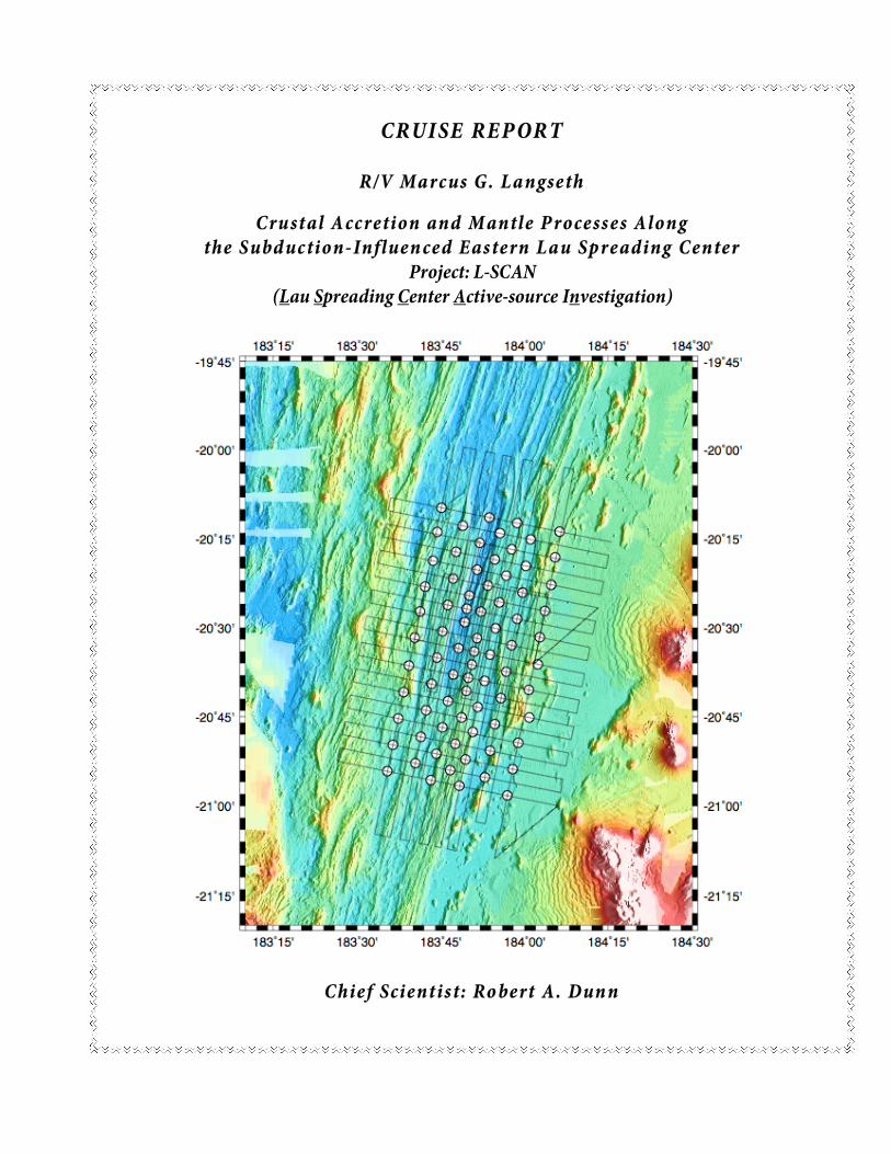
CRUI SE RE P OR T
R/V Marcus G. Langseth
Crustal A ccretion and Mantle P rocesses Along
the S ubd uction- Influen ced Eastern Lau Sp reading Center Project: L-SCAN
(Lau Spreading Center Active-source Investigation)
Chief Scientist: Ro bert A. Dun n
2
Table of Contents Table of Contents .................................................................................................................................. 2 Scientific and Operational Objectives..................................................................................................... 5 Science Summary.................................................................................................................................. 6 Scientific Overview................................................................................................................................. 6 Scientific Objectives............................................................................................................................... 7 Operational Objectives (cruise plan and experiment layout)................................................................... 7 Lau Basin Currents .............................................................................................................................. 16 Contingency Plan................................................................................................................................. 16 L-SCAN Operations Report.................................................................................................................. 17 Narrative .............................................................................................................................................. 18 Instrument Drop Points ........................................................................................................................ 26 Instrument Recoveries ......................................................................................................................... 28 Shot Line Log Campaigns I and II ........................................................................................................ 29 Instrument Deployment Map ................................................................................................................ 33 Shot Line Map – Campaign I................................................................................................................ 34 Shot Line Map – Campaign II............................................................................................................... 35 Instrument Performance ......................................................................... Error! Bookmark not defined. Assessment of OBS Operations and Instrumentation .......................................................................... 37 Assessment of Ship Operations ........................................................................................................... 39 APPENDIX 1: OBS Instrument Configuration....................................................................................... 42 APPENDIX 2: WHOI OBSIP Cruise Report.......................................................................................... 45 APPENDIX 3: Assessment of Background Noise and Firing Interval.................................................... 48 APPENDIX 4: Marine Mammal Observation Summary ........................................................................ 49 APPENDIX 5: OBS Deployment & Logging Protocol............................................................................ 50 APPENDIX 6: OBS Deploy Log Keeping ............................................................................................. 50 APPENDIX 7: Line Change Orders ...................................................................................................... 51 APPENDIX 8: Local and Global Earthquakes Occurring during the OBS experiment........................... 52 APPENDIX 9: Gravity Reduction Information ....................................................................................... 54 APPENDIX 10: Towing Configurations.................................................... Error! Bookmark not defined. APPENDIX 11: XBT Drops ..................................................................... Error! Bookmark not defined. APPENDIX 12: Clearances.................................................................................................................. 61
(R. Dunn – Honolulu, HI March 2009)
3
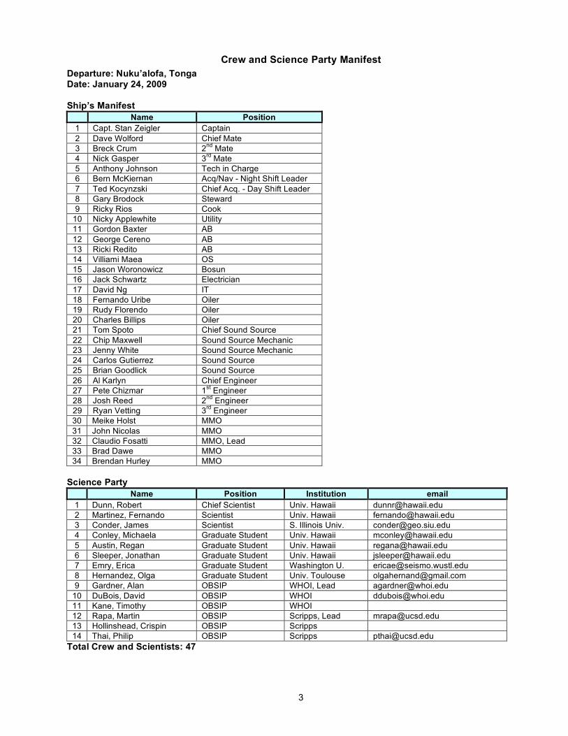
Crew and Science Party Manifest Departure: Nuku’alofa, Tonga Date: January 24, 2009 Ship’s Manifest
Name Position 1 Capt. Stan Zeigler Captain 2 Dave Wolford Chief Mate 3 Breck Crum 2nd Mate 4 Nick Gasper 3rd Mate 5 Anthony Johnson Tech in Charge 6 Bern McKiernan Acq/Nav - Night Shift Leader 7 Ted Kocynzski Chief Acq. - Day Shift Leader 8 Gary Brodock Steward 9 Ricky Rios Cook
10 Nicky Applewhite Utility 11 Gordon Baxter AB 12 George Cereno AB 13 Ricki Redito AB 14 Villiami Maea OS 15 Jason Woronowicz Bosun 16 Jack Schwartz Electrician 17 David Ng IT 18 Fernando Uribe Oiler 19 Rudy Florendo Oiler 20 Charles Billips Oiler 21 Tom Spoto Chief Sound Source 22 Chip Maxwell Sound Source Mechanic 23 Jenny White Sound Source Mechanic 24 Carlos Gutierrez Sound Source 25 Brian Goodlick Sound Source 26 Al Karlyn Chief Engineer 27 Pete Chizmar 1st Engineer 28 Josh Reed 2nd Engineer 29 Ryan Vetting 3rd Engineer 30 Meike Holst MMO 31 John Nicolas MMO 32 Claudio Fosatti MMO, Lead 33 Brad Dawe MMO 34 Brendan Hurley MMO
Science Party
Name Position Institution email 1 Dunn, Robert Chief Scientist Univ. Hawaii [email protected] 2 Martinez, Fernando Scientist Univ. Hawaii [email protected] 3 Conder, James Scientist S. Illinois Univ. [email protected] 4 Conley, Michaela Graduate Student Univ. Hawaii [email protected] 5 Austin, Regan Graduate Student Univ. Hawaii [email protected] 6 Sleeper, Jonathan Graduate Student Univ. Hawaii [email protected] 7 Emry, Erica Graduate Student Washington U. [email protected] 8 Hernandez, Olga Graduate Student Univ. Toulouse [email protected] 9 Gardner, Alan OBSIP WHOI, Lead [email protected]
10 DuBois, David OBSIP WHOI [email protected] 11 Kane, Timothy OBSIP WHOI 12 Rapa, Martin OBSIP Scripps, Lead [email protected] 13 Hollinshead, Crispin OBSIP Scripps 14 Thai, Philip OBSIP Scripps [email protected]
Total Crew and Scientists: 47

4
R/V Marcus Langseth Technical Support Organizational Chart Technical Support Organizational Chart
Cruise MGL0903 v1.2
Tech-in-charge Anthony Johnson
Chief Acquisition Ted Koczynski Chief IT/Nav Anthony Johnson
Operational Watches Acquisition and IT/Navigation Midnight to Noon Noon to Midnight
Watch Leader Watch Leader
Bern McKiernan Ted Koczynski
Acquisition Leader Nav Leader Acquisition Leader Nav Leader Bern McKiernan Bern McKiernan Ted Koczynski David Ng
Acq Watch Stander A Nav Watch Stander A Acq Watch Stander A Nav Watch Stander A Visiting Science Party Visiting Science Party Visiting Science Party Visiting Science Party
Chief Sound Source Handling Tom Spoto
Operational Watches Sound Source/Handling Midnight to Noon Noon to Midnight
Watch Leader Watch Leader Brian Goodick Carlos Gutierrez
Sound Source Mechanic Sound Source Mechanic
Chip Maxwell Jenny White Captain Stan Zeigler Chief Engineer Al Karlyn PI Robert Dunn Science Party Leader Shift 1 Fernando Martinez Science Party Leader Shift 2 James Conder
Regan Austin Jonathan Sleeper Erica Emry
Olga Hernandez Michaela Conley
NOTES: *Each of the three Technical Groups (Acquisition, IT/Nav, and Sound Source/Handling) will fully transition to 2 watches when necessary to leave flexibility to support Seismic gear deployment. Science operations manned 24 hours whenever data is being collected. *Tech-in-charge and PI will work out schedule for watch standing visiting science party including shift leaders and on deck responsibilities and seismic deployments.

5
Scientific and Operational Objectives
6
Science Summary The Eastern Lau Spreading Center (ELSC) is a RIDGE Integrated Study Site where researchers
from many disciples come together to study the integrated mantle-to-microbes processes interacting within the ridge system. The spreading center exhibits a tremendous along-strike variation in geochemistry, petrology, spreading rate, crustal structure, and morphology. Because of this variation, the ELSC represents the optimum location for an experiment to study the relationship between mantle melt production, mantle flow, and spreading center processes. This active-source seismic experiment is one part of a two-part study (the other being a large broadband seismic study of the mantle beneath the ELSC) that is designed to test the following hypothesis: Variations in the mantle melt supply control ridge crest features such as morphology, thermal structure, and hydrothermal venting.
The experiment consists of 84 OBS deployments along a 150 km section of the ELSC extending from north of the inflated Valu Fa region to the magma-starved northern ELSC where the axial melt lens is absent. Lines of ridge-parallel and ridge-perpendicular airgun shots cover the area and provide seismic sources for imaging the crust and uppermost ~2 km of the mantle. This experiment will image structure on a scale of 1-3 km, and will provide detailed constraints on thermal structure and melt distribution immediately beneath the ELSC.
Scientific Overview The generation and transport of melt beneath oceanic spreading centers is one of the most
important geological process shaping the earth; it produces over two thirds of the global crust and is a primary means of chemical differentiation in the Earth. Yet the physical mechanisms controlling melt aggregation, transport, and collection within the axial crust are poorly understood. Most of our understanding of melt dynamics beneath ridges results from petrological and geochemical studies of the materials output by this process. In contrast, the spatial distribution of melt and the associated convective mantle structure have been imaged in few locations. Both surface morphology and geochemical outputs vary substantially along and between ridge segments so our goal is to take advantage of this fact to understand the relationship between mantle melt processes and the surface manifestation of these processes along the ridge. Careful documentation of both crustal and upper mantle structure along a single ridge segment, combined with modeling of mantle flow and melting are required to accomplish this goal. To date, such a combined 3-D imaging study has not been attempted along an oceanic spreading center.
The Eastern Lau Spreading Center (ELSC) provides one of the best locations for this work. The ELSC was chosen by the RIDGE 2000 (R2K) program for focused, multidisciplinary study, due to its backarc setting and the exceptional along-strike variability in chemistry, petrology, morphology, and hydrothermal flux. Detailed 3-D imaging of the uppermost mantle and crust will allow us to fulfill, in part, three of the seven objectives of the Lau Integrated Studies Implementation Plan: (1) characterize the mantle flow pattern and the magma production and transport regions; (2) understand the origin and consequences of gradients in lava composition along the ELSC; (3) understand the spatial-temporal variations of crustal architecture.
The active-source seismic experiment along the ELSC is designed to image uppermost mantle and crustal properties and their along-strike variation over a 150-km-long section of the ELSC to evaluate whether variations in the mantle melt supply control ridge crest features such as morphology, thermal structure, and hydrothermal venting.
The Eastern Lau Spreading Center The ELSC is characterized by rapid along-strike changes in many variables and thus presents an
excellent opportunity to understand the importance of various forcing functions in controlling ridge processes. Going from south to north, the spreading rate increases from 40 to 95 mm/yr [Zellmer and Taylor, 2001], the ridge axis changes from inflated to an axial valley [Martinez and Taylor, 2002], the melt lens disappears and layer 2A thins [Collier and Sinha, 1992; Harding et al., 2000], the crustal composition changes from andesitic to tholeiitic [Vallier et al., 1991; Peate et al., 2001], and isotopic

7
values change from Pacific to Indian Ocean mantle domains [Pearce et al., 1995]. Furthermore, the depth of the spreading axis increases and the mantle Bouguer gravity values increase [Fouquet et al., 1991; Bortnikov et al., 1993]. The distance of the ridge from the Tonga arc increases from 30 km to 100 km and the depth to the underlying slab increases from 150 km to 250 km.
It is hypothesized that many of the along-strike changes in the ELSC are produced by variable geochemical and petrological inputs via subduction, with the greatest influence in the south where the ridge is closest to the arc [Pearce et al., 1995; Martinez and Taylor, 2002]. It is likely that the unusual chemistry observed in Valu Fa hydrothermal vents, particularly the enrichment in Zn and other metals, is related to the enriched andesitic crustal composition and the influence of slab-derived volatiles [Fouquet et al., 1993; Herzig et al., 1993]. Thus, mantle-melting processes appear to play a vital role in forming the chemical systems that are fundamental to the Lau vent ecosystems.
Despite the inferences that can be made based on petrology and geochemistry, how mantle melting may influence the ELSC to produce these systematic variations are unknown. The missing links are (1) the pattern of flow in the mantle wedge and its relation to variation in melt chemistry, distribution, and migration paths to the ridge; and (2) the pattern of melt delivery to the ridge axis at the base of the crust, and (3) crustal-level melt storage and thermal structure.
Scientific Objectives Using a grid of OBSs extending 150 km along the ELSC, with a station spacing of ~8 km, and a grid
of airgun shot lines, with a spacing of 1-4, km this experiment is designed to: (1) Map the seismic velocity structure of the uppermost mantle beneath a 150-km-long section of
the spreading center. (2) Image the seismic velocity structure of the crust along this 150-km-long section of the ELSC. (3) Construct a map of crustal thickness variations along and across the spreading center.
Operational Objectives (cruise plan and experiment layout)
Number of OBS Deployments and Recoveries The experiment is divided into two OBS grids (A and B) and two shot grids (1 and 2) OBS Deployments Group A: 59 OBS Recoveries Group A: 25 Number left on seafloor after first shooting leg: 34 OBS OBS Deployments Group B: 18 OBS Recoveries Group B: 52 (including those from group A left on the seafloor) Total Number of deployments: 77 deployments Total Number of recoveries: 77 recoveries
Parameters Used to Design the Active-Source Seismic Experiment Ship speed deploy/recovery: 8 knots Ship speed shooting: 4.5 knots Airgun depth = 9 m (the marine mammal permit asks for 9-12 m) Shot interval: every 450 meters (~3.25 min) Station deployment time (each): 1 hour Station recovery time (each): 2.5 hours Basic Plan: 59 instruments are placed on the seafloor (group A) and then Shot Pattern #1 is carried over these instruments. 25 of these instruments are then recovered (the southern section of the OBS grid) and 18 of these are reset and re-deployed to the north of the OBS that are still on the seafloor. Shot Pattern #2 is carried out over all instruments on the seafloor. All 52 instruments are then recovered. Figures below show the layout of Groups A and B and the Shot Lines for Patterns #1 and #2.
8
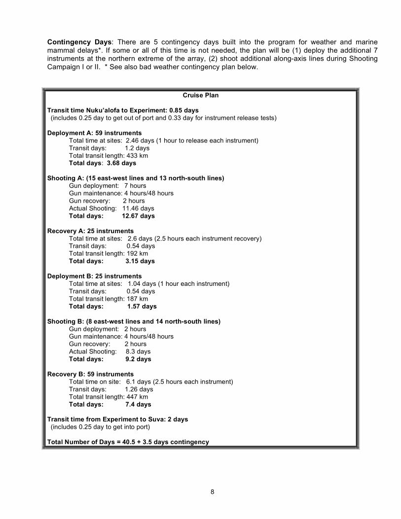
Contingency Days: There are 5 contingency days built into the program for weather and marine mammal delays*. If some or all of this time is not needed, the plan will be (1) deploy the additional 7 instruments at the northern extreme of the array, (2) shoot additional along-axis lines during Shooting Campaign I or II. * See also bad weather contingency plan below.
Cruise Plan Transit time Nuku’alofa to Experiment: 0.85 days (includes 0.25 day to get out of port and 0.33 day for instrument release tests) Deployment A: 59 instruments Total time at sites: 2.46 days (1 hour to release each instrument) Transit days: 1.2 days Total transit length: 433 km Total days: 3.68 days Shooting A: (15 east-west lines and 13 north-south lines) Gun deployment: 7 hours Gun maintenance: 4 hours/48 hours Gun recovery: 2 hours Actual Shooting: 11.46 days Total days: 12.67 days Recovery A: 25 instruments Total time at sites: 2.6 days (2.5 hours each instrument recovery) Transit days: 0.54 days Total transit length: 192 km Total days: 3.15 days Deployment B: 25 instruments Total time at sites: 1.04 days (1 hour each instrument) Transit days: 0.54 days Total transit length: 187 km Total days: 1.57 days Shooting B: (8 east-west lines and 14 north-south lines) Gun deployment: 2 hours Gun maintenance: 4 hours/48 hours Gun recovery: 2 hours Actual Shooting: 8.3 days Total days: 9.2 days Recovery B: 59 instruments Total time on site: 6.1 days (2.5 hours each instrument) Transit days: 1.26 days Total transit length: 447 km Total days: 7.4 days Transit time from Experiment to Suva: 2 days (includes 0.25 day to get into port) Total Number of Days = 40.5 + 3.5 days contingency
9
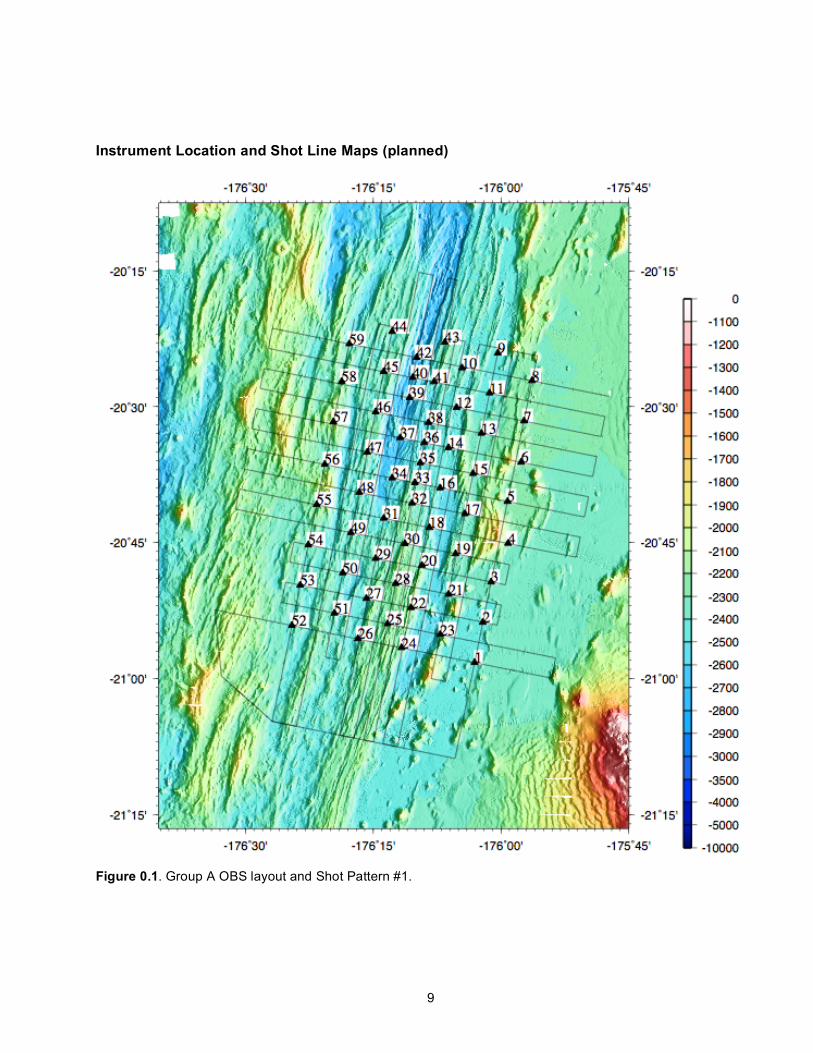
Instrument Location and Shot Line Maps (planned)
Figure 0.1. Group A OBS layout and Shot Pattern #1.
10
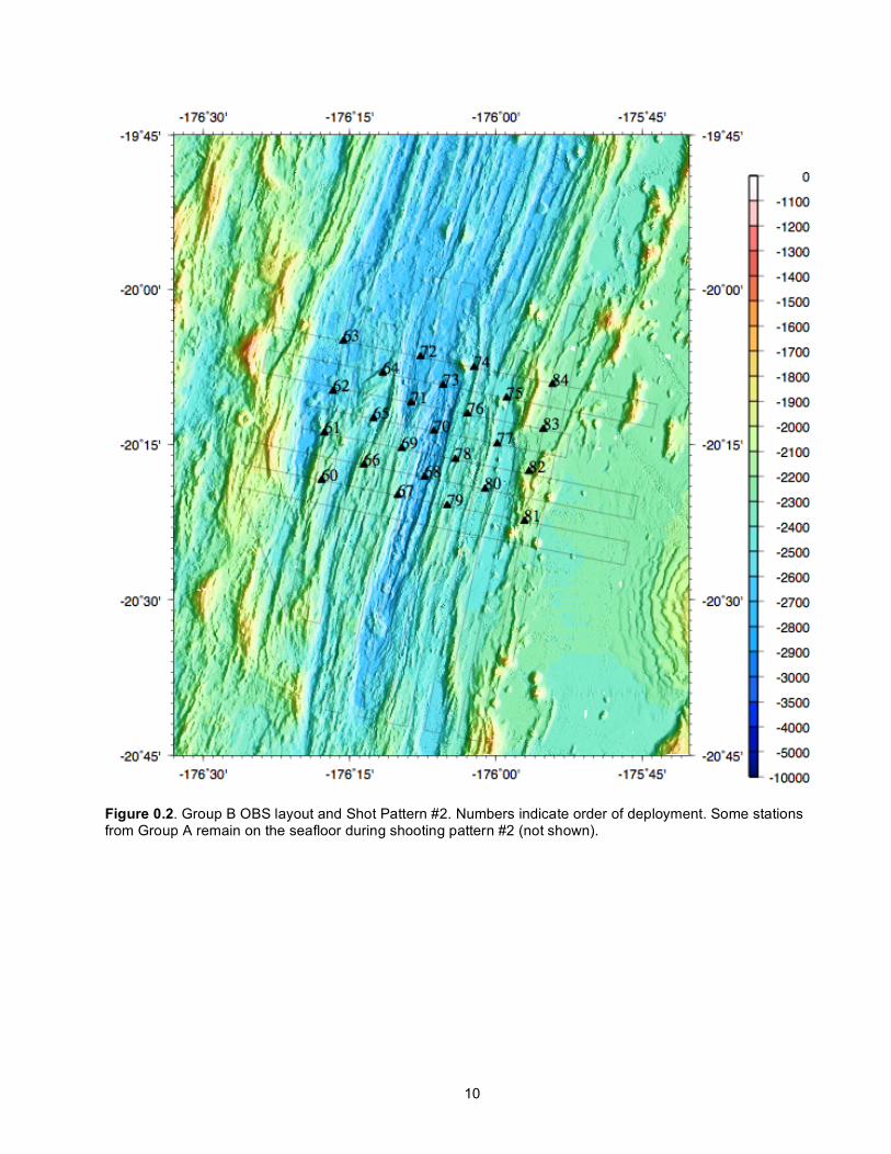
Figure 0.2. Group B OBS layout and Shot Pattern #2. Numbers indicate order of deployment. Some stations from Group A remain on the seafloor during shooting pattern #2 (not shown).
11
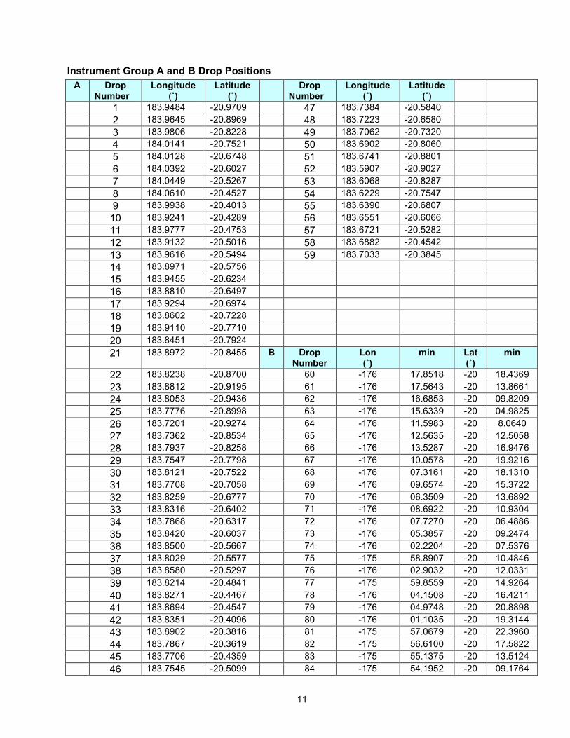
Instrument Group A and B Drop Positions A Drop
Number Longitude
(˚) Latitude
(˚) Drop
Number Longitude
(˚) Latitude
(˚)
1 183.9484 -20.9709 47 183.7384 -20.5840 2 183.9645 -20.8969 48 183.7223 -20.6580 3 183.9806 -20.8228 49 183.7062 -20.7320 4 184.0141 -20.7521 50 183.6902 -20.8060 5 184.0128 -20.6748 51 183.6741 -20.8801 6 184.0392 -20.6027 52 183.5907 -20.9027 7 184.0449 -20.5267 53 183.6068 -20.8287 8 184.0610 -20.4527 54 183.6229 -20.7547 9 183.9938 -20.4013 55 183.6390 -20.6807 10 183.9241 -20.4289 56 183.6551 -20.6066 11 183.9777 -20.4753 57 183.6721 -20.5282 12 183.9132 -20.5016 58 183.6882 -20.4542 13 183.9616 -20.5494 59 183.7033 -20.3845 14 183.8971 -20.5756 15 183.9455 -20.6234 16 183.8810 -20.6497 17 183.9294 -20.6974 18 183.8602 -20.7228 19 183.9110 -20.7710 20 183.8451 -20.7924 21 183.8972 -20.8455 B Drop
Number Lon (˚)
min Lat (˚)
min
22 183.8238 -20.8700 60 -176 17.8518 -20 18.4369 23 183.8812 -20.9195 61 -176 17.5643 -20 13.8661 24 183.8053 -20.9436 62 -176 16.6853 -20 09.8209 25 183.7776 -20.8998 63 -176 15.6339 -20 04.9825 26 183.7201 -20.9274 64 -176 11.5983 -20 8.0640 27 183.7362 -20.8534 65 -176 12.5635 -20 12.5058 28 183.7937 -20.8258 66 -176 13.5287 -20 16.9476 29 183.7547 -20.7798 67 -176 10.0578 -20 19.9216 30 183.8121 -20.7522 68 -176 07.3161 -20 18.1310 31 183.7708 -20.7058 69 -176 09.6574 -20 15.3722 32 183.8259 -20.6777 70 -176 06.3509 -20 13.6892 33 183.8316 -20.6402 71 -176 08.6922 -20 10.9304 34 183.7868 -20.6317 72 -176 07.7270 -20 06.4886 35 183.8420 -20.6037 73 -176 05.3857 -20 09.2474 36 183.8500 -20.5667 74 -176 02.2204 -20 07.5376 37 183.8029 -20.5577 75 -175 58.8907 -20 10.4846 38 183.8580 -20.5297 76 -176 02.9032 -20 12.0331 39 183.8214 -20.4841 77 -175 59.8559 -20 14.9264 40 183.8271 -20.4467 78 -176 04.1508 -20 16.4211 41 183.8694 -20.4547 79 -176 04.9748 -20 20.8898 42 183.8351 -20.4096 80 -176 01.1035 -20 19.3144 43 183.8902 -20.3816 81 -175 57.0679 -20 22.3960 44 183.7867 -20.3619 82 -175 56.6100 -20 17.5822 45 183.7706 -20.4359 83 -175 55.1375 -20 13.5124 46 183.7545 -20.5099 84 -175 54.1952 -20 09.1764
12
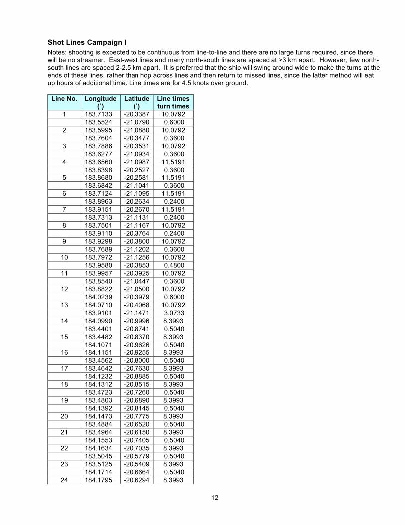
Shot Lines Campaign I Notes: shooting is expected to be continuous from line-to-line and there are no large turns required, since there will be no streamer. East-west lines and many north-south lines are spaced at >3 km apart. However, few north-south lines are spaced 2-2.5 km apart. It is preferred that the ship will swing around wide to make the turns at the ends of these lines, rather than hop across lines and then return to missed lines, since the latter method will eat up hours of additional time. Line times are for 4.5 knots over ground.
Line No. Longitude (˚)
Latitude (˚)
Line times turn times
1 183.7133 -20.3387 10.0792 183.5524 -21.0790 0.6000
2 183.5995 -21.0880 10.0792 183.7604 -20.3477 0.3600
3 183.7886 -20.3531 10.0792 183.6277 -21.0934 0.3600
4 183.6560 -21.0987 11.5191 183.8398 -20.2527 0.3600
5 183.8680 -20.2581 11.5191 183.6842 -21.1041 0.3600
6 183.7124 -21.1095 11.5191 183.8963 -20.2634 0.2400
7 183.9151 -20.2670 11.5191 183.7313 -21.1131 0.2400
8 183.7501 -21.1167 10.0792 183.9110 -20.3764 0.2400
9 183.9298 -20.3800 10.0792 183.7689 -21.1202 0.3600
10 183.7972 -21.1256 10.0792 183.9580 -20.3853 0.4800
11 183.9957 -20.3925 10.0792 183.8540 -21.0447 0.3600
12 183.8822 -21.0500 10.0792 184.0239 -20.3979 0.6000
13 184.0710 -20.4068 10.0792 183.9101 -21.1471 3.0733
14 184.0990 -20.9996 8.3993 183.4401 -20.8741 0.5040
15 183.4482 -20.8370 8.3993 184.1071 -20.9626 0.5040
16 184.1151 -20.9255 8.3993 183.4562 -20.8000 0.5040
17 183.4642 -20.7630 8.3993 184.1232 -20.8885 0.5040
18 184.1312 -20.8515 8.3993 183.4723 -20.7260 0.5040
19 183.4803 -20.6890 8.3993 184.1392 -20.8145 0.5040
20 184.1473 -20.7775 8.3993 183.4884 -20.6520 0.5040
21 183.4964 -20.6150 8.3993 184.1553 -20.7405 0.5040
22 184.1634 -20.7035 8.3993 183.5045 -20.5779 0.5040
23 183.5125 -20.5409 8.3993 184.1714 -20.6664 0.5040
24 184.1795 -20.6294 8.3993

13
183.5205 -20.5039 0.5040 25 183.5286 -20.4669 8.3993
184.1875 -20.5924 0.5040 26 184.1955 -20.5554 8.3993
183.5366 -20.4299 0.5040 27 183.5447 -20.3929 8.3993
184.2036 -20.5184 0.5040 28 184.2116 -20.4814 8.3993
183.5527 -20.3559 * 11.56 to shoot just the lines at 4.5 knots
Instrument Recovery Group A (partial) and Instrument Group B Drop Positions Recovery
Order East_Longitude
(˚) Latitude
(˚) Drop
Number Drop
Number deg min deg min
1 183.6390 -20.6807 55 60 -176 17.8518 -20 18.4369 2 183.7062 -20.7320 49 61 -176 17.5643 -20 13.8661 3 183.6229 -20.7547 54 62 -176 16.6853 -20 09.8209 4 183.6902 -20.8060 50 63 -176 15.6339 -20 04.9825 5 183.6068 -20.8287 53 64 -176 11.5983 -20 8.0640 6 183.5907 -20.9027 52 65 -176 12.5635 -20 12.5058 7 183.6741 -20.8801 51 66 -176 13.5287 -20 16.9476 8 183.7201 -20.9274 26 67 -176 10.0578 -20 19.9216 9 183.7776 -20.8998 25 68 -176 07.3161 -20 18.1310 10 183.7362 -20.8534 27 69 -176 09.6574 -20 15.3722 11 183.7937 -20.8258 28 70 -176 06.3509 -20 13.6892 12 183.7547 -20.7798 29 71 -176 08.6922 -20 10.9304 13 183.8121 -20.7522 30 72 -176 07.7270 -20 06.4886 14 183.7708 -20.7058 31 73 -176 05.3857 -20 09.2474 15 183.8602 -20.7228 18 74 -176 02.2204 -20 07.5376 16 183.9110 -20.7710 19 75 -175 58.8907 -20 10.4846 17 183.8451 -20.7924 20 76 -176 02.9032 -20 12.0331 18 183.8972 -20.8455 21 77 -175 59.8559 -20 14.9264 19 183.8238 -20.8700 22 78 -176 04.1508 -20 16.4211 20 183.8053 -20.9436 24 79 -176 04.9748 -20 20.8898 21 183.8812 -20.9195 23 80 -176 01.1035 -20 19.3144 22 183.9484 -20.9709 1 81 -175 57.0679 -20 22.3960 23 183.9645 -20.8969 2 82 -175 56.6100 -20 17.5822 24 183.9806 -20.8228 3 83 -175 55.1375 -20 13.5124 25 184.0141 -20.7521 4 84 -175 54.1952 -20 09.1764
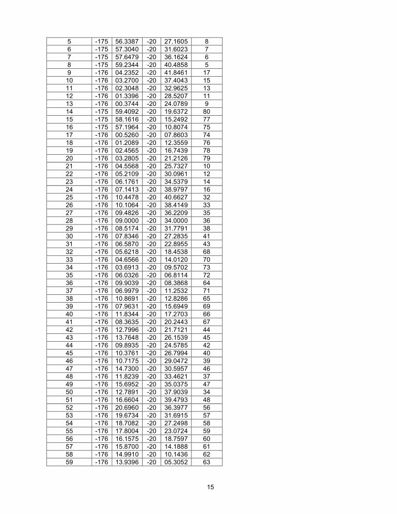
Shot Lines Campaign II Notes: East-west lines and many north-south lines are spaced at >3 km apart. However, a few north-south lines are spaced 2.5 km apart.
Line No.
deg min deg min
01 -175 58.2692 -20 36.0441 -175 50.8003 -20 01.6731
02 -175 52.4946 -20 01.3504 -176 01.6871 -20 43.6531
03 -176 03.9462 -20 43.2227 -175 55.9028 -20 06.2079
04 -175 57.5971 -20 05.8851 -176 05.6406 -20 42.9000

14
total time for lines is 8.2 days at 4.5 knots over ground.
Instrument Recovery - Group B and Group A (remaining) after Shot Pattern #2 Recovery
Order deg min deg min drop
number 1 -175 52.5009 -20 09.4991 84 2 -175 53.4431 -20 13.8351 83 3 -175 54.9157 -20 17.9050 82 4 -175 55.3735 -20 22.7187 81
05 -176 07.3349 -20 42.5773 -175 58.1424 -20 00.2745
06 -175 59.8368 -19 59.9518 -176 09.0292 -20 42.2545
07 -176 11.2884 -20 41.8242 -176 02.0959 -19 59.5215
08 -176 03.5078 -19 59.2525 -176 12.7003 -20 41.5552
09 -176 14.1123 -20 41.2863 -176 04.9198 -19 58.9836
10 -176 06.6141 -19 58.6608 -176 15.8066 -20 40.9635
11 -176 17.5010 -20 40.6408 -176 09.4575 -20 03.6259
12 -176 11.7167 -20 03.1956 -176 18.0365 -20 32.2787
13 -176 19.7308 -20 31.9559 -176 12.2619 -19 57.5850
14 -176 13.9563 -19 57.2622 -176 21.4252 -20 31.6332
15 -176 26.3543 -20 19.1302 -175 46.8196 -20 26.6609
16 -175 46.3370 -20 24.4400 -176 25.8717 -20 16.9093
17 -176 25.3891 -20 14.6884 -175 45.8544 -20 22.2191
18 -175 45.3718 -20 19.9982 -176 19.9647 -20 13.4088
19 -176 19.4820 -20 11.1879 -175 52.7962 -20 16.2712
20 -175 52.3136 -20 14.0503 -176 23.9413 -20 08.0257
21 -176 23.4587 -20 05.8048 -175 43.9240 -20 13.3356
22 -175 43.4414 -20 11.1147 -176 22.9761 -20 03.5839
23 -176 22.9761 -20 03.5839 -176 22.4935 -20 01.3630
24 -176 01.0318 -20 05.4511 -176 11.6491 -20 54.3108
25 -176 13.9082 -20 53.8804 -176 03.2909 -20 05.0208
26 -175 53.6896 -20 06.8497 -176 04.3070 -20 55.7093
27 -176 24.0743 -20 51.9440 -176 12.9514 -20 00.7577
15
5 -175 56.3387 -20 27.1605 8 6 -175 57.3040 -20 31.6023 7 7 -175 57.6479 -20 36.1624 6 8 -175 59.2344 -20 40.4858 5 9 -176 04.2352 -20 41.8461 17 10 -176 03.2700 -20 37.4043 15 11 -176 02.3048 -20 32.9625 13 12 -176 01.3396 -20 28.5207 11 13 -176 00.3744 -20 24.0789 9 14 -175 59.4092 -20 19.6372 80 15 -175 58.1616 -20 15.2492 77 16 -175 57.1964 -20 10.8074 75 17 -176 00.5260 -20 07.8603 74 18 -176 01.2089 -20 12.3559 76 19 -176 02.4565 -20 16.7439 78 20 -176 03.2805 -20 21.2126 79 21 -176 04.5568 -20 25.7327 10 22 -176 05.2109 -20 30.0961 12 23 -176 06.1761 -20 34.5379 14 24 -176 07.1413 -20 38.9797 16 25 -176 10.4478 -20 40.6627 32 26 -176 10.1064 -20 38.4149 33 27 -176 09.4826 -20 36.2209 35 28 -176 09.0000 -20 34.0000 36 29 -176 08.5174 -20 31.7791 38 30 -176 07.8346 -20 27.2835 41 31 -176 06.5870 -20 22.8955 43 32 -176 05.6218 -20 18.4538 68 33 -176 04.6566 -20 14.0120 70 34 -176 03.6913 -20 09.5702 73 35 -176 06.0326 -20 06.8114 72 36 -176 09.9039 -20 08.3868 64 37 -176 06.9979 -20 11.2532 71 38 -176 10.8691 -20 12.8286 65 39 -176 07.9631 -20 15.6949 69 40 -176 11.8344 -20 17.2703 66 41 -176 08.3635 -20 20.2443 67 42 -176 12.7996 -20 21.7121 44 43 -176 13.7648 -20 26.1539 45 44 -176 09.8935 -20 24.5785 42 45 -176 10.3761 -20 26.7994 40 46 -176 10.7175 -20 29.0472 39 47 -176 14.7300 -20 30.5957 46 48 -176 11.8239 -20 33.4621 37 49 -176 15.6952 -20 35.0375 47 50 -176 12.7891 -20 37.9039 34 51 -176 16.6604 -20 39.4793 48 52 -176 20.6960 -20 36.3977 56 53 -176 19.6734 -20 31.6915 57 54 -176 18.7082 -20 27.2498 58 55 -176 17.8004 -20 23.0724 59 56 -176 16.1575 -20 18.7597 60 57 -176 15.8700 -20 14.1888 61 58 -176 14.9910 -20 10.1436 62 59 -176 13.9396 -20 05.3052 63

16
Lau Basin Currents Ocean surface currents effect transit speeds over-ground and shooting speeds and timing.
Surface currents are seasonal and exhibit short-term fluctuations, in particular during storms. Near-real time ocean surface currents, derived from satellite altimeter and scatterometer data, can be found at http://www.oscar.noaa.gov/datadisplay. A recent 5-day average (about Dec. 21, 2008) shows SSE flow at <0.100 m/s (0.36 km/hr). The monthly mean (about Dec. 15, 2008) shows SE flow at ~0.05 m/s (~0.18 km/hr). A seasonal mean from Feb. 1, 2007 to March 1, 2008 shows a SSE flow at ~0.04 m/s (~0.14 km/hr). For a current of 0.20 km/hr and a shot interval of 450 meters, the timing of the shots will be delayed/advanced by only ~5 s. If surface currents become as high as 1 km/hr the shot timing will be delayed/advanced by 26 s. Since we wish to keep the shots greater than 3 minutes apart, only currents over 1 km/hr are of concern when the ship is traveling with the current.
Deep basin currents are expected to be significantly less than surface currents, but do impact instrument drops. The LAUB-FLEX project directly samples the deep-flow field in the Lau Basin with floats that are programmed to drift at depth and periodically return to the surface in order to transmit data back to shore. Once a month the float data are quality-controlled, processed and made publicly available at www.ldeo.columbia.edu/~ant/LAUB-FLEX as downloadable data and web animations.
Currently, there are 10 floats, which were deployed during three cruises in 2004-05, drifting in the Lau Basin. The available data span three- and four-week-long drift cycles and cover a good portion of the Lau Basin. The mean meridional (north-south) velocity recorded so far is 4.1(+/-0.9) mm/s (0.014 km/hr) to the north, while the zonal (east-west) flow is as yet indistinguishable from zero. Individual float-cycle-averaged velocities are omni-directional and associated with speeds up to 9 cm/s. Thus, on timescales of months, horizontal flow in the deep interior of the Lau Basin is primarily omni-directional, while the observed northward mean flow becomes important on longer (multi-year) timescales. Peak velocities averaged over 3-4 week intervals can be as high as 30 mm/s (~0.100 km/hr). Peak velocities averaged over shorter time periods are unknown. It can take 1-1.5 hours for an instrument to fall to the bottom (30 m/min); seafloor locations may be off by 100-150 m.
Contingency Plan In the event that storms or other unforeseeable circumstances divert the ship for a short period of
time from its main objectives of carrying out a seismic tomography study of the Eastern Lau Spreading Center, the following activities are proposed: (1) Shoot lines of airguns to the moored hydrophone array of Bohnenstiehl et al. Airgun shots are used
to calibrate acoustic wave travel time and transmission loss models. Proposed lines: (183.000˚E, 23.000˚S) to (182.000˚E, 23.000˚S) (182.883˚E, 20.000˚S) to (182.883˚E, 18.500˚S) (183.000˚E, 20.425˚S) to (182.250˚E, 20.425˚S) (183.000˚E, 21.000˚S) to (183.500˚E, 19.750˚S)
(2) Survey areas for seismometer deployments that will occur during the Wiens et al. broadband seismic cruise that is expected to occur in late 2009. There are some gaps in the current seafloor maps of the area and pre-surveying those gaps would save time for positioning instruments during the Wiens et al cruise that is expected to occur late 2009.
(3) Survey areas of the Western Lau basin using a multi-beam system and gravimeter. Large gaps in
the detailed seafloor maps of the western basin could be at least partly filled in, so as to achieve a better understanding of the history of plate tectonics of the area (see justification below).
No time-frame for this potential work is specified (other than the time-frame of the cruise Jan 16-
Feb 28). We would return to the main experiment site immediately when able to do so. Depending on a storm’s location and track, we could divert to any area in the region from 178.5W - 176.5W; 23S-18.5S. Which includes excursions into territory claimed by Fiji.
17
MGL0903
L-SCAN: Lau Spreading Center Active-Source INvestigation
L-SCAN Operations Report
18
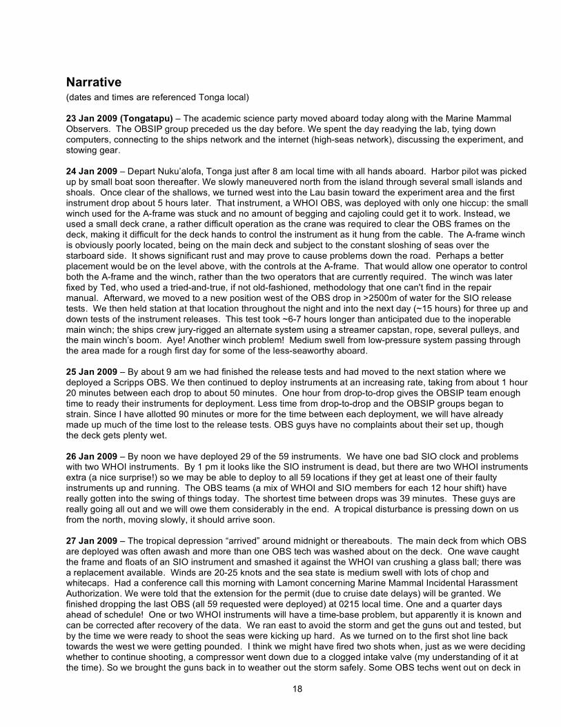
Narrative (dates and times are referenced Tonga local) 23 Jan 2009 (Tongatapu) – The academic science party moved aboard today along with the Marine Mammal Observers. The OBSIP group preceded us the day before. We spent the day readying the lab, tying down computers, connecting to the ships network and the internet (high-seas network), discussing the experiment, and stowing gear. 24 Jan 2009 – Depart Nuku’alofa, Tonga just after 8 am local time with all hands aboard. Harbor pilot was picked up by small boat soon thereafter. We slowly maneuvered north from the island through several small islands and shoals. Once clear of the shallows, we turned west into the Lau basin toward the experiment area and the first instrument drop about 5 hours later. That instrument, a WHOI OBS, was deployed with only one hiccup: the small winch used for the A-frame was stuck and no amount of begging and cajoling could get it to work. Instead, we used a small deck crane, a rather difficult operation as the crane was required to clear the OBS frames on the deck, making it difficult for the deck hands to control the instrument as it hung from the cable. The A-frame winch is obviously poorly located, being on the main deck and subject to the constant sloshing of seas over the starboard side. It shows significant rust and may prove to cause problems down the road. Perhaps a better placement would be on the level above, with the controls at the A-frame. That would allow one operator to control both the A-frame and the winch, rather than the two operators that are currently required. The winch was later fixed by Ted, who used a tried-and-true, if not old-fashioned, methodology that one can't find in the repair manual. Afterward, we moved to a new position west of the OBS drop in >2500m of water for the SIO release tests. We then held station at that location throughout the night and into the next day (~15 hours) for three up and down tests of the instrument releases. This test took ~6-7 hours longer than anticipated due to the inoperable main winch; the ships crew jury-rigged an alternate system using a streamer capstan, rope, several pulleys, and the main winch’s boom. Aye! Another winch problem! Medium swell from low-pressure system passing through the area made for a rough first day for some of the less-seaworthy aboard. 25 Jan 2009 – By about 9 am we had finished the release tests and had moved to the next station where we deployed a Scripps OBS. We then continued to deploy instruments at an increasing rate, taking from about 1 hour 20 minutes between each drop to about 50 minutes. One hour from drop-to-drop gives the OBSIP team enough time to ready their instruments for deployment. Less time from drop-to-drop and the OBSIP groups began to strain. Since I have allotted 90 minutes or more for the time between each deployment, we will have already made up much of the time lost to the release tests. OBS guys have no complaints about their set up, though the deck gets plenty wet. 26 Jan 2009 – By noon we have deployed 29 of the 59 instruments. We have one bad SIO clock and problems with two WHOI instruments. By 1 pm it looks like the SIO instrument is dead, but there are two WHOI instruments extra (a nice surprise!) so we may be able to deploy to all 59 locations if they get at least one of their faulty instruments up and running. The OBS teams (a mix of WHOI and SIO members for each 12 hour shift) have really gotten into the swing of things today. The shortest time between drops was 39 minutes. These guys are really going all out and we will owe them considerably in the end. A tropical disturbance is pressing down on us from the north, moving slowly, it should arrive soon. 27 Jan 2009 – The tropical depression “arrived” around midnight or thereabouts. The main deck from which OBS are deployed was often awash and more than one OBS tech was washed about on the deck. One wave caught the frame and floats of an SIO instrument and smashed it against the WHOI van crushing a glass ball; there was a replacement available. Winds are 20-25 knots and the sea state is medium swell with lots of chop and whitecaps. Had a conference call this morning with Lamont concerning Marine Mammal Incidental Harassment Authorization. We were told that the extension for the permit (due to cruise date delays) will be granted. We finished dropping the last OBS (all 59 requested were deployed) at 0215 local time. One and a quarter days ahead of schedule! One or two WHOI instruments will have a time-base problem, but apparently it is known and can be corrected after recovery of the data. We ran east to avoid the storm and get the guns out and tested, but by the time we were ready to shoot the seas were kicking up hard. As we turned on to the first shot line back towards the west we were getting pounded. I think we might have fired two shots when, just as we were deciding whether to continue shooting, a compressor went down due to a clogged intake valve (my understanding of it at the time). So we brought the guns back in to weather out the storm safely. Some OBS techs went out on deck in
19
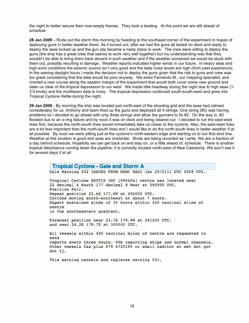
the night to better secure their now-empty frames. They took a beating. At this point we are still ahead of schedule. 28 Jan 2009 – Rode out the storm this morning by heading to the southeast corner of the experiment in hopes of deploying guns in better weather there. As it turned out, after we had the guns all tested on deck and ready to deploy the seas kicked up and the gun slip became a nasty place to work. The crew were willing to deploy the guns (the ship has a great crew that seems to work very well together) but my understanding was that they wouldn’t be able to bring them back aboard in such weather and if the weather worsened we would be stuck with them out, possibly resulting in damage. Weather reports indicated higher winds in our future. In heavy seas and high wind conditions the seismic source isn’t very good and the data noise levels are high (from past experience). In the waning daylight hours I made the decision not to deploy the guns given that the risk to guns and crew was too great considering that the data would be poor anyway. We woke Fernando M., our mapping specialist, and charted a new course along the eastern margin of the experiment that would both cover some new ground and steer us clear of the tropical depression to our west. We made little headway during the night due to high seas (1-3.5 knots) and the multibeam data is noisy. The tropical depression continued south-south-west and grew into Tropical Cyclone Hettie during the night. 29 Jan 2009 - By morning the ship was located just north-east of the shooting grid and the seas had calmed considerably for us. Anthony and team fired up the guns and deployed all 4 strings. One string (#2) was having problems so I decided to go ahead with only three strings and allow the gunners to fix #2. On the way in, #2 flooded due to an o-ring failure and by noon it was on deck and being cleared out. I decided to run the east-west lines first, because the north-south lines would immediately take us closer to the cyclone. Also, the east-west lines are a bit less important than the north-south lines and I would like to do the north-south lines in better weather if at all possible. By noon we were sitting just at the cyclone’s north-eastern edge and starting on to our first shot line. Weather at this location is good and seas are moderate. Shots are being recorded as I write. We are a fraction of a day behind schedule. Hopefully we can get back on and stay on, or a little ahead of, schedule. There is another tropical disturbance coming down the pipeline; it is currently located north-west of New Caledonia. We won’t see it for several days if at all.
20
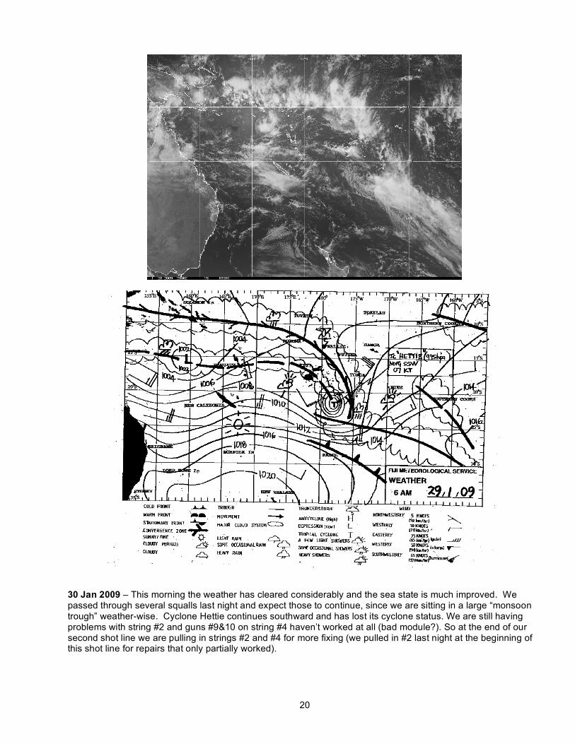
30 Jan 2009 – This morning the weather has cleared considerably and the sea state is much improved. We passed through several squalls last night and expect those to continue, since we are sitting in a large “monsoon trough” weather-wise. Cyclone Hettie continues southward and has lost its cyclone status. We are still having problems with string #2 and guns #9&10 on string #4 haven’t worked at all (bad module?). So at the end of our second shot line we are pulling in strings #2 and #4 for more fixing (we pulled in #2 last night at the beginning of this shot line for repairs that only partially worked).
21
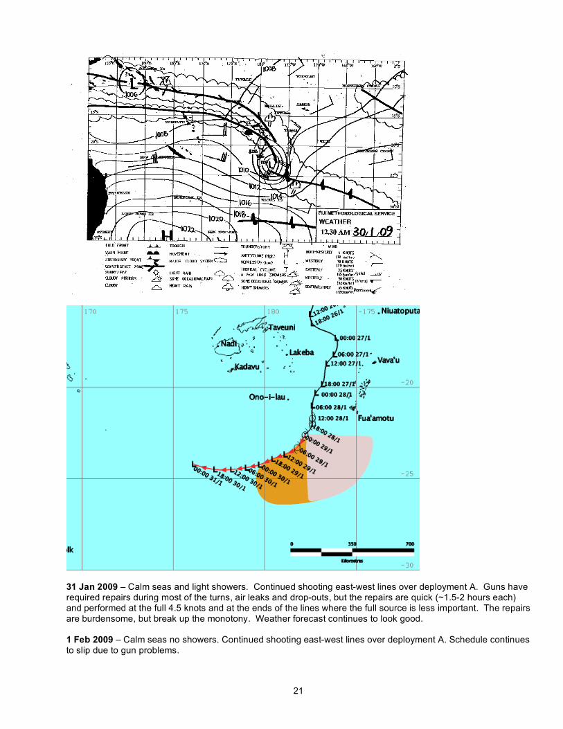
31 Jan 2009 – Calm seas and light showers. Continued shooting east-west lines over deployment A. Guns have required repairs during most of the turns, air leaks and drop-outs, but the repairs are quick (~1.5-2 hours each) and performed at the full 4.5 knots and at the ends of the lines where the full source is less important. The repairs are burdensome, but break up the monotony. Weather forecast continues to look good. 1 Feb 2009 – Calm seas no showers. Continued shooting east-west lines over deployment A. Schedule continues to slip due to gun problems.
22
2 Feb 2009 – Calm seas no showers earlier in the day; a little swell and showers later in the day. Continued shooting east-west lines over deployment A. Dropped the ends of half-a-dozen shot lines due to delays resulting from gun problems. Once these east-west lines are completed, we should be back on schedule. Apparently Tom’s torque wrench used to tighten the bolts on the guns etc. is untrustworthy – i.e., he doesn’t trust the calibration scale – and he is unsure if the bolts are set at the right torque. This may be part of the cause of some of the gun problems. We tested a depressor today for the magnetometer. The issue there is that it must be towed well behind the ship to avoid data corruption from the ship’s structure. However, the magnetometer cannot be towed past the guns for fear of entangling the cable with the guns. The magi manufacturer does make a depressor and a weight set designed to push the tow depth below the gun depth allowing for a longer ship-to-magi offset, but we don’t have that aboard, so we are designing one of our own. Initial tests indicate that it is a little small, so we will do some more modifications and tests tomorrow. 3 Feb 2009 – Calm seas and gray skies with occasional showers. Regional weather looks good overall. There is a large low-pressure system developing 400 km to the west-north-west and is so far stationary in location. Fernando edited the bathymetry that we have collected so far to date. Looks good. He was even able to clean up the very noisy data that we collected the night of the cyclone. Gun one on string one went down today. We pulled it in and the shield around the solenoid block had literally torn loose (1/4” steel) due to the guns crashing into each other during recoil on firing. Lamont needs to consider attaching spreader bars on the gun clusters, especially the front ones, since this recoil problem appears to be the source of many of our gun woes and has resulted in a lot of lost time and data during this experiment. 4 Feb 2009 – Ended East-west lines for deployment A and began north-south lines. Had one gun problem at the end of the first line, but was easily fixed after pulling in String #1. The guns have been better behaved for the past 36 hours. Magi depressor tests did not turn out as well as hoped and we won’t tow it behind the guns. 5 Feb 2009 – Calm seas good weather, continued shooting. Continued repairing guns as necessary. Depressor tests for magnetometer fail. We will tow Maggie forward of guns. 6 Feb 2009 – The gun array seemed to fall apart this morning beginning around 5:30 am. Air leaks, gun loss, miss firing, cross firings, and other inexplicable problems. We pulled in #3 and the gunners worked on it for some time, meanwhile #2 fell apart. We went off line and began 20 s shots to sort it all out. By turning various guns on and off and switching coms and power links Anthony and team were able to get most of the array back up to full power. We went back online and continued down the shot line, but we will need to go back and reshoot the missed portion of the line later. The tropical depression that was west of us has moved south-west of us. Though it continues to move southward, things could get nasty for us if it were to hook north. For that reason, we’ll continue shooting the main lines while the weather is good, rather than loop back around to pick up the lost line. Lots of complaints from the gunners that they do not have enough spare parts aboard. We are starting to fall behind schedule bit by bit due to the gun problems. We have about 3 days of shooting left before picking up the first 25 instruments and before bringing in the guns for a major overhaul. 7 Feb 2009 – Calm seas good weather. Continuing shooting north-south lines. Added a small 6 hour loop to the experiment to re-shoot a section of line that we missed yesterday due to the gun problems. Finished the day without any further gun problems. 8 Feb 2009 – Calm seas and sunny weather. The topical depression to our southwest continued moving south last night, entering cool waters and eventually faded away. Weather looks exceptional for the next 2-3 days at the least. We had a BBQ on the sundeck tonight. It was enjoyed greatly by all. We have been shooting a long time and everyone needed something new. 9 Feb 2009 – Calm seas and scattered showers. 10 Feb 2009 – Finished last shot of the first shot campaign at just before 1100 local. The guns and PAM were out of the water in a little over an hour after that. We then had the first OBS aboard by 1330. The next instrument was aboard after another 1.5 hours. 11 Feb 2009 – Continued good weather; instrument recoveries progressing rapidly.

23
15 Feb 2009 – Completed recoveries several days earlier. All 25 instruments were aboard in ~36 hours. We then redeployed all 25 instruments in about 19 hours start-to-finish. By Feb 13 0800 local we were deploying the guns and lining up for the first shot line. Shot Campaign II will take about 9 days and we may have some time for a few more shot lines than planned. Found out yesterday that our Tongan permits for operating in their EEZ are unclear as to when we would need to be finished with all research activities. Our main permit lasts until March 3, and although we were to understand that we had an extension until March 11, the extension was not clearly verified via a letter from the Tongan government. Rupert at the marine office swears that we are OK to continue operations after the 3rd, but it is painfully clear that the paperwork is not in order. He has been in contact with the State Dept. for clarification, but it looks like that clarification will need to come from the U.S. Embassy in Fiji (which also services Tongan requests). We are all waiting to hear the outcome. Came across two fishing vessels late in the day. They had out long lines. We skirted the tail buoy of the closest line by maybe 90 meters just as the sun set. 16 Feb 2009 – Calm seas and weather. Continued shooting; continued to have miscellaneous gun problems. Still not enough spare parts. 17 Feb 2009 – Same. Lost full volume for a good portion of one of the north-south lines on the western side of the ridge. Decided not to loop around to fill the gap since we do not have permission to operate here after the 3rd and we need to continue filling in the grid. 18 Feb 2009 – More “assurances” from the marine office about the Tongan extension. And then finally an admission that the Tongan’s have not yet given us the date change permission and that we will be operating after March 3 in violation of the current agreement. Rupert is looking into getting the continuation and also some clarification as to whether we must stop all activities on March 3 or just the airgun activity. Permission to have gear on the seafloor after March 3 is all we need to carry out the cruise plan, since shooting will stop before March 3 in any case. 20 Feb 2009 – Capt’n received some clarification from the marine office as to whether we can have gear on the seafloor after March 3. The answer is affirmative, so we will stick to the plan and continue shooting the lines for Campaign II. Although we will be pulling in the guns around the 25th or so, we need the time after March 3rd to pull up the instruments if there are any delays due to weather or instruments. 23 Feb 2009 – Still working on reading the SEGY seismic data files from the two groups. The file formats have changed and also the two OBS groups, which are supposed to form a coherent instrument pool, do not use the same information in the SEG-Y headers. 24 Feb 2009 – Found mistake in SIO header (lat and lon swapped by accident) and that should clear up things immensely. Working on analysis code to pick the data using either OBS group’s format; also Michaela is writing an instrument relocation code to use the water waves to locate the instrument seafloor positions. 25 Feb 2009 – Last shot at 0400 LT (shot #113119). Our last lines included re-shooting some areas where we did not have full gun volume, and we re-shot 7 previously shot lines so that we could stack the data for better returns, since initial analysis of the data revealed poor mantle returns. Guns were out of the water by ~0600 LT and we started recovering instruments at first light. Instrument recoveries progressing rapidly due to mild sea state. Fernando started laying out his tracks for surveying the western basin. The lack of a Tongan permit after the 3rd is still a pain in the neck as far as the surveying is concerned. First we rushed through the seismic experiment to get it done and now we will rush through the mapping phase. We may need to do all Tongan areas first and then proceed to Fijian waters. Capt’n is concerned about “shallow areas” in the survey plan. Shoals are marked on his charts, but they look to be in 2000+ meters of water according to the existing multibeam data. 26 Feb 2009 – Emailed Kelepi Mafi at the Tongan Ministry that is in charge of vetting our permits. I told him that our current permits runs out on March 3 and was wondering if he had seen our request for extension. He was very apologetic that we had not received the permission, and that he had not yet seen our UN request form. He later replied that he would see to it that the appropriate cabinet minister would see our request. 27 Feb 2009 – No word from Kelepi today, other than a request for collaboration with Fernando Martinez to write up something on the Tonga-Kermadec Ridge which he needs for an extended continental shelf claim by his government. Looks like we won’t get the extension in time. Soon we will begin executing an alternate plan.
24
28 Feb 2009 – Pulled up last OBS at ~2100 LT. The good weather facilitated getting all instruments up in record time (1.5 hours station-to-station). 100% instrument recovery; 84 total deployments and 84 recoveries. Secured deck, including deck winch used for instrument recoveries; deployed magnetometer, turned on multi-beam and 3.55 KHz systems, which had been turned off for instrument recoveries (pings interfere with ability to talk to instruments). Transited west to begin geophysical mapping. 01 March 2009 – Mapping all day along EEZ border in Tongan waters in order to complete Tongan regions before permit runs out. The coverage we are getting is not optimal. 02 March 2009 – Kelepi wrote to say that the request wasn’t considered last week, but it would be considered at a March 4th cabinet meeting. Unfortunately that is too late and we have already rushed through our plans to be “finished” by the 3rd midnight. 03 March 2009 – Continued mapping. Western basin shows signs of more recent volcanism. Also sediments here are easily penetrated by the 3.55KHz system, unlike the volcanoclastics to the east of the spreading center. 04 March 2009 - Continued mapping. Heard that our extension was approved during yesterdays cabinet meeting. 05 March 2009 – Continued mapping. 06 March 2009 – Continued mapping. 07 March 2009 - Continued mapping. Heading to port. 08 March 2009 – In port.
25
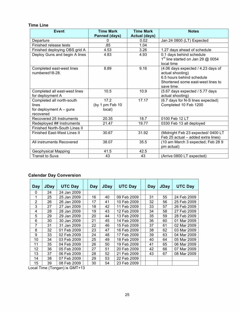
Time Line Event Time Mark
Panned (days) Time Mark
Actual (days) Notes
Departure 0 0.02 Jan 24 0800 (LT) Expected Finished release tests .85 1.04 Finished deploying OBS grid A 4.53 3.26 1.27 days ahead of schedule Deploy Guns and begin A lines 4.83 4.93 0.1 days behind schedule
1st line started on Jan 29 @ 0054 local time
Completed east-west lines numbered18-28.
8.89 9.16 (4.06 days expected / 4.23 days of actual shooting) 6.5 hours behind schedule Shortened some east-west lines to save time.
Completed all east-west lines for deployment A
10.5 10.9 (5.67 days expected / 5.77 days actual shooting)
Completed all north-south lines for deployment A – guns recovered
17.2 (by 1 pm Feb 10
local)
17.17
(6.7 days for N-S lines expected) Completed 10 Feb 1200
Recovered 25 Instruments 20.35 18.7 0100 Feb 12 LT Redeployed ## Instruments 21.47 19.77 0330 Feb 13 all deployed Finished North-South Lines II Finished East-West Lines II 30.67 31.92 (Midnight Feb 23 expected/ 0400 LT
Feb 25 actual – added extra lines) All instruments Recovered 38.07 35.5 (10 am March 3 expected; Feb 28 9
pm actual) Geophysical Mapping 41.5 42.5 Transit to Suva 43 43 (Arrive 0800 LT expected)
Calendar Day Conversion
Day JDay UTC Day Day JDay UTC Day Day JDay UTC Day 0 24 24 Jan 2009 1 25 25 Jan 2009 16 40 09 Feb 2009 31 55 24 Feb 2009 2 26 26 Jan 2009 17 41 10 Feb 2009 32 56 25 Feb 2009 3 27 27 Jan 2009 18 42 11 Feb 2009 33 57 26 Feb 2009 4 28 28 Jan 2009 19 43 12 Feb 2009 34 58 27 Feb 2009 5 29 29 Jan 2009 20 44 13 Feb 2009 35 59 28 Feb 2009 6 30 30 Jan 2009 21 45 14 Feb 2009 36 60 01 Mar 2009 7 31 31 Jan 2009 22 46 15 Feb 2009 37 61 02 Mar 2009 8 32 01 Feb 2009 23 47 16 Feb 2009 38 62 03 Mar 2009 9 33 02 Feb 2009 24 48 17 Feb 2009 39 63 04 Mar 2009 10 34 03 Feb 2009 25 49 18 Feb 2009 40 64 05 Mar 2009 11 35 04 Feb 2009 26 50 19 Feb 2009 41 65 06 Mar 2009 12 36 05 Feb 2009 27 51 20 Feb 2009 42 66 07 Mar 2009 13 37 06 Feb 2009 28 52 21 Feb 2009 43 67 08 Mar 2009 14 38 07 Feb 2009 29 53 22 Feb 2009 15 39 08 Feb 2009 30 54 23 Feb 2009
Local Time (Tongan) is GMT+13

26
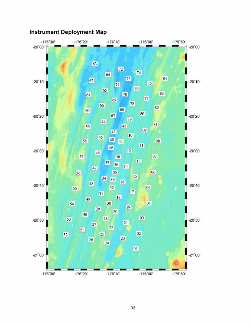
Instrument Drop Points
Instrument Group A Drop Order and Positions Drop Order
Site No.
Drop Longitude
(˚)
Drop Latitude
(˚)
Water Depth
(m)
Inst. Man.
1 1 -176˚ 03.103 -20˚ 58.239 2406 W 2 24 -176˚ 11.918 -20˚ 56.570 2202 S 3 23 -176˚ 07.041 -20˚ 55.177 2293 S 4 2 -176˚ 02.158 -20˚ 53.810 2416 W 5 3 -176˚ 01.192 -20˚ 49.380 2334 W 6 4 -175˚ 59.153 -20˚ 45.139 2200 W 7 5 -175˚ 59.229 -20˚ 40.529 2255 S 8 6 -175˚ 57.740 -20˚ 36.789 2285 S 9 7 -175˚ 57.319 -20˚ 31.614 2242 S 10 8 -175˚ 56.345 -20˚ 27.167 2289 S 11 9 -176˚ 00.395 -20˚ 24.066 2431 S 12 10 -176˚ 04.736 -20˚ 25.588 2452 S 13 11 -176˚ 01.408 -20˚ 28.491 2411 S 14 12 -176˚ 05.204 -20˚ 30.094 2447 S 15 13 -176˚ 02.291 -20˚ 32.968 2333 S 16 14 -176˚ 06.199 -20˚ 34.533 2425 S 17 15 -176˚ 03.277 -20. 37.402 2313 S 18 16 -176˚ 07.203 -20˚ 39.002 2416 S 19 17 -176˚ 04.267 -20˚ 41.841 2300 W 20 18 -176˚ 08.398 -20˚ 43.362 2330 W 21 19 -176˚ 05.396 -20˚ 46.225 2304 W 22 20 -176˚ 09.338 -20˚ 47.513 2217 W 23 21 -176˚ 06.147 -20˚ 50.738 2389 W 24 22 -176˚ 10.626 -20˚ 52.206 2099 W 25 25 -176˚ 13.370 -20˚ 53.974 2247 W 26 26 -176˚ 16.805 -20˚ 55.638 2422 W 27 27 -176˚ 15.811 -20˚ 51.196 2483 W 28 28 -176˚ 12.362 -20˚ 49.547 2143 W 29 29 -176˚ 14.697 -20˚ 46.790 2359 W 30 30 -176˚ 11.266 -20˚ 45.134 2129 W 31 31 -176˚ 13.708 -20˚ 42.390 2480 S 32 32 -176˚ 10.465 -20˚ 40.662 2215 S 33 33 -176˚ 10.186 -20˚ 38.271 2418 S 34 34 -176˚ 12.794 -20˚ 37.916 2567 S 35 35 -176˚ 09.488 -20˚ 36.229 2469 S 36 36 -176˚ 09.039 -20˚ 33.984 2540 S 37 37 -176˚ 11.847 -20˚ 33.460 2541 S 38 38 -176˚ 08.511 -20˚ 31.786 2511 S 39 39 -176˚ 10.733 -20˚ 29.047 2656 S 40 40 -176˚ 10.402 -20˚ 26.794 2663 S 41 41 -176˚ 07.653 -20˚ 27.353 2418 S 42 42 -176˚ 09.880 -20˚ 24.600 2704 S 43 43 -176˚ 06.626 -20˚ 22.886 2364 S 44 44 -176˚ 12.969 -20˚ 21.655 2343 S 45 45 -176˚ 13.777 -20˚ 26.146 2375 S 46 46 -176˚ 14.756 -20˚ 30.599 2375 W 47 47 -176˚ 15.716 -20˚ 35.016 2273 W 48 48 -176˚ 16.684 -20˚ 39.478 2367 W 49 49 -176˚ 17.638 -20˚ 43.947 2365 W 50 50 -176˚ 18.595 -20˚ 48.384 2432 W 51 51 -176˚ 19.500 -20˚ 52.827 2250 S 52 52 -176˚ 24.599 -20˚ 54.168 2408 S 53 53 -176˚ 23.572 -20˚ 49.737 2413 S 54 54 -176˚ 22.652 -20˚ 45.304 2330 S 55 55 -176˚ 21.700 -20˚ 40.848 2243 S

27
56 56 -176˚ 20.722 -20˚ 36.407 2313 S 57 57 -176˚ 19.739 -20˚ 31.718 2032 S 58 58 -176˚ 18.719 -20˚ 27.228 2259 S 59 59 -176˚ 17.830 -20˚ 23.045 2447 S
Instrument Group B Drop Order and Positions Drop Order
Site No.
Drop Longitude
(˚)
Drop Latitude
(˚)
Water Depth
(m)
Inst. Man
1 60 -176˚ 17.868 -20˚ 18.417 2298 W 2 61 -176˚ 17.582 -20˚ 13.856 2390 W 3 62 -176˚ 16.702 -20˚ 09.788 2607 W 4 63 -176˚ 15.653 -20˚ 04.944 2623 W 5 64 -176˚ 11.596 -20˚ 08.067 2466 W 6 65 -176˚ 12.548 -20˚ 12.493 2489 W 7 66 -176˚ 13.528 -20˚ 16.906 2317 S 8 67 -176˚ 10.040 -20˚ 19.863 2365 S 9 68 -176˚ 07.316 -20˚ 18.115 2758 S 10 69 -176˚ 09.637 -20˚ 15.374 2421 S 11 70 -176˚ 06.350 -20˚ 13.674 2780 S 12 71 -176˚ 08.671 -20˚ 10.933 2583 S 13 72 -176˚ 07.700 -20˚ 06.455 2712 S 14 73 -176˚ 05.331 -20˚ 09.223 2675 S 15 74 -176˚ 02.147 -20˚ 07.460 2504 W 16 75 -175˚ 58.868 -20˚ 10.501 2352 W 17 76 -176˚ 02.892 -20˚ 12.011 2382 W 18 77 -175˚ 59.842 -20˚ 14.927 2432 W 19 78 -176˚ 04.191 -20˚ 16.421 2445 W 20 79 -176˚ 04.984 -20˚ 20.910 2392 W 21 80 -176˚ 01.103 -20˚ 19.282 2416 W 22 81 -175˚ 57.062 -20˚ 22.408 2132 W 23 82 -175˚ 56.649 -20˚ 17.570 2150 W 24 83 -175˚ 55.146 -20˚ 13.491 2207 W 25 84 -175˚ 54.202 -20˚ 09.144 2259 W
28
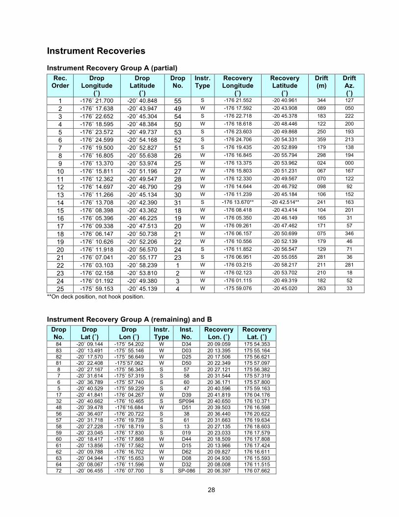
Instrument Recoveries
Instrument Recovery Group A (partial) Rec.
Order Drop
Longitude (˚)
Drop Latitude
(˚)
Drop No.
Instr. Type
Recovery Longitude
(˚)
Recovery Latitude
(˚)
Drift (m)
Drift Az. (˚)
1 -176˚ 21.700 -20˚ 40.848 55 S -176 21.552 -20 40.961 344 127
2 -176˚ 17.638 -20˚ 43.947 49 W -176 17.592 -20 43.908 089 050
3 -176˚ 22.652 -20˚ 45.304 54 S -176 22.718 -20 45.378 183 222
4 -176˚ 18.595 -20˚ 48.384 50 W -176 18.618 -20 48.446 122 200
5 -176˚ 23.572 -20˚ 49.737 53 S -176 23.603 -20 49.868 250 193
6 -176˚ 24.599 -20˚ 54.168 52 S -176 24.706 -20 54.331 359 213
7 -176˚ 19.500 -20˚ 52.827 51 S -176 19.435 -20 52.899 179 138
8 -176˚ 16.805 -20˚ 55.638 26 W -176 16.845 -20 55.794 298 194
9 -176˚ 13.370 -20˚ 53.974 25 W -176 13.375 -20 53.962 024 000
10 -176˚ 15.811 -20˚ 51.196 27 W -176 15.803 -20 51.231 067 167
11 -176˚ 12.362 -20˚ 49.547 28 W -176 12.330 -20 49.567 070 122
12 -176˚ 14.697 -20˚ 46.790 29 W -176 14.644 -20 46.792 098 92
13 -176˚ 11.266 -20˚ 45.134 30 W -176 11.239 -20 45.184 106 152
14 -176˚ 13.708 -20˚ 42.390 31 S -176 13.670** -20 42.514** 241 163
15 -176˚ 08.398 -20˚ 43.362 18 W -176 08.418 -20 43.414 104 201
16 -176˚ 05.396 -20˚ 46.225 19 W -176 05.350 -20 46.149 165 31
17 -176˚ 09.338 -20˚ 47.513 20 W -176 09.261 -20 47.462 171 57
18 -176˚ 06.147 -20˚ 50.738 21 W -176 06.157 -20 50.699 075 346
19 -176˚ 10.626 -20˚ 52.206 22 W -176 10.556 -20 52.139 179 46
20 -176˚ 11.918 -20˚ 56.570 24 S -176 11.852 -20 56.547 129 71
21 -176˚ 07.041 -20˚ 55.177 23 S -176 06.951 -20 55.055 281 36
22 -176˚ 03.103 -20˚ 58.239 1 W -176 03.215 -20 58.217 211 281
23 -176˚ 02.158 -20˚ 53.810 2 W -176 02.123 -20 53.702 210 18
24 -176˚ 01.192 -20˚ 49.380 3 W -176 01.115 -20 49.319 182 52
25 -175˚ 59.153 -20˚ 45.139 4 W -175 59.076 -20 45.020 263 33 **On deck position, not hook position.
Instrument Recovery Group A (remaining) and B Drop No.
Drop Lat (˚)
Drop Lon (˚)
Instr. Type
Inst. No.
Recovery Lon. (˚)
Recovery Lat. (˚)
84 -20˚ 09.144 -175˚ 54.202 W D34 20 09.059 175 54.353 83 -20˚ 13.491 -175˚ 55.146 W D03 20 13.395 175 55.164 82 -20˚ 17.570 -175˚ 56.649 W D25 20 17.506 175 56.621 81 -20˚ 22.408 -175˚57.062 W D50 20 22.349 175 57.097 8 -20˚ 27.167 -175˚ 56.345 S 57 20 27.121 175 56.382 7 -20˚ 31.614 -175˚ 57.319 S 58 20 31.544 175 57.319 6 -20˚ 36.789 -175˚ 57.740 S 60 20 36.171 175 57.800 5 -20˚ 40.529 -175˚ 59.229 S 47 20 40.596 175 59.163 17 -20˚ 41.841 -176˚ 04.267 W D39 20 41.819 176 04.176 32 -20˚ 40.662 -176˚ 10.465 S SP094 20 40.650 176 10.371 48 -20˚ 39.478 -176˚16.684 W D51 20 39.503 176 16.598 56 -20˚ 36.407 -176˚ 20.722 S 38 20 36.440 176 20.622 57 -20˚ 31.718 -176˚ 19.739 S 61 20 31.663 176 19.634 58 -20˚ 27.228 -176˚ 18.719 S 13 20 27.135 176 18.603 59 -20˚ 23.045 -176˚ 17.830 S 019 20 23.033 176 17.579 60 -20˚ 18.417 -176˚ 17.868 W D44 20 18.509 176 17.808 61 -20˚ 13.856 -176˚ 17.582 W D15 20 13.966 176 17.424 62 -20˚ 09.788 -176˚ 16.702 W D62 20 09.827 176 16.611 63 -20˚ 04.944 -176˚ 15.653 W D08 20 04.930 176 15.593 64 -20˚ 08.067 -176˚ 11.596 W D32 20 08.008 176 11.515 72 -20˚ 06.455 -176˚ 07.700 S SP-086 20 06.397 176 07.662

29
73 -20˚09.223 -176˚ 05.331 S SP-085 20 09.218 176 05.297 74 -20˚ 07.460 -176˚ 02.147 W D11 20 07.387 176 02.146 75 -20˚ 10.501 -175˚ 58.868 W D49 20 10.467 175 58.853 77 -20˚ 14.927 -175˚ 59.842 W D09 20 14.888 175 59.763 80 -20˚ 19.282 -176˚ 01.103 W D10 20 19.191 176 01.048 9 -20˚ 24.066 -176˚ 00.395 S 95 20 24.095 176 00.408 11 -20˚ 28.491 -176˚ 01.408 S 10 20 28.546 176 01.370 13 -20˚ 32.968 -176˚ 02.291 S 136 20 32.979 176 02.242 15 -20. 37.402 -176˚ 03.277 S 0078 20 37.309 176 03.207 16 -20˚ 39.002 -176˚ 07.203 S 093 20 38.849 176 07.166 33 -20˚ 38.271 -176˚ 10.186 S 0001 20 38.173 176 10.242 34 -20˚ 37.916 -176˚ 12.794 S SP-092 20 37.911 176 12.827 47 -20˚ 35.016 -176˚ 15.716 W D40 20 35.047 176 15.744 46 -20˚ 30.599 -176˚ 14.756 W D07 20 30.625 176 14.765 45 -20˚ 26.146 -176˚ 13.777 S SP-138 20 26.201 176 13.536 44 -20˚ 21.655 -176˚ 12.969 S SP-141 20 21.730 176 12.735 66 -20˚ 16.906 -176˚ 13.528 S 3 20 16.771 176 13.462 65 -20˚ 12.493 -176˚ 12.548 W D26 20 12.337 176 12.481 71 -20˚ 10.933 -176˚ 08.671 S 0056 20 10.755 176 08.671 70 -20˚ 13.674 -176˚ 06.350 S SP-088 20 13.552 176 06.423 76 -20˚ 12.011 -176˚ 02.892 W D55 20 12.023 176 02.883 78 -20˚ 16.421 -176˚ 04.191 W D02 20 16.470 176 04.126 79 -20˚ 20.910 -176˚ 04.984 W D06 20 20.917 176 04.988 10 -20˚ 25.588 -176˚ 04.736 S 17 20 25.585 176 04.732 12 -20˚ 30.094 -176˚ 05.204 S 75 20 30.087 176 05.151 14 -20˚ 34.533 -176˚ 06.199 S 002 20 34.420 176 06.206 35 -20˚ 36.229 -176˚ 09.488 S SP-089 20 36.128 176 09.538 36 -20˚ 33.984 -176˚ 09.039 S 090 20 33.943 176 09.159 37 -20˚ 33.460 -176˚ 11.847 S 0032 20 33.529 176 11.966 38 -20˚ 31.786 -176˚ 08.511 S 0021 20 31.908 176 08.574 39 -20˚ 29.047 -176˚ 10.733 S 0055 20 29.198 176 10.810 40 -20˚ 26.794 -176˚ 10.402 S SP-139 20 26.901 176 10.388 41 -20˚ 27.353 -176˚ 07.653 S SP-137 20 27.408 176 07.648 42 -20˚ 24.600 -176˚ 09.880 S 0027 20 24.622 176 09.855 43 -20˚ 22.886 -176˚ 06.626 S 0077 20 22.863 176 06.645 67 -20˚19.863 -176˚ 10.040 S SP-087 20 19.769 176 10.091 68 -20˚ 18.115 -176˚ 07.316 S SP-140 20 18.021 176 07.386 69 -20˚ 15.374 -176˚ 09.637 S 0007 20 15.281 176 09.648
Shot Line Log Campaigns I and II Seq
# Line # Date Time (UTC) Date
Time (UTC)
1 Lau_Ax001 2 Lau_A002 - - - - 3 Lau_A028 29-Jan-09 00:54:00 29-Jan-09 10:01:18 4 Lau_A027 29-Jan-09 11:58:06 29-Jan-09 19:57:33 5 Lau_A026 29-Jan-09 22:52:00 30-Jan-09 07:11:37 6 Lau_A025 30-Jan-09 07:40:09 30-Jan-09 16:19:59 7 Lau_A024 30-Jan-09 16:46:52 31-Jan-09 01:34:16 8 Lau_A023 31-Jan-09 02:00:58 31-Jan-09 10:41:55 9 Lau_A022 31-Jan-09 11:11:57 01-Jan-09 19:34:40 10 Lau_A021 31-Jan-09 20:04:36 01-Feb-09 01:12:55 11 Lau_A022A 01-Feb-09 01:51:03 01-Feb-09 02:47:51 12 Lau_A021 01-Feb-09 03:12:38 01-Feb-09 08:00:02 13 Lau_A020 01-Feb-09 08:28:26 01-Feb-09 17:06:32 14 WTURNS 01-Feb-09 17:11:17 01-Feb-09 17:33:00
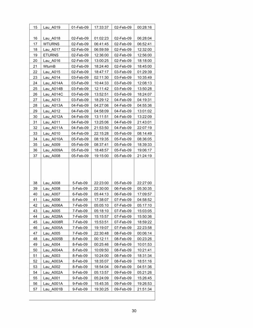
30
15 Lau_A019 01-Feb-09 17:33:37 02-Feb-09 00:28:16
16 Lau_A018 02-Feb-09 01:02:23 02-Feb-09 06:28:04 17 WTURNS 02-Feb-09 06:41:45 02-Feb-09 06:52:41 18 Lau_A017 02-Feb-09 06:59:59 02-Feb-09 12:32:00 19 ETURNS 02-Feb-09 12:36:00 02-Feb-09 12:56:00 20 Lau_A016 02-Feb-09 13:00:25 02-Feb-09 18:18:00 21 WturnB 02-Feb-09 18:24:40 02-Feb-09 18:45:00 22 Lau_A015 02-Feb-09 18:47:17 03-Feb-09 01:29:39 23 Lau_A014 03-Feb-09 02:11:30 03-Feb-09 10:35:49 24 Lau_A014A 03-Feb-09 10:44:33 03-Feb-09 12:08:13 25 Lau_A014B 03-Feb-09 12:11:42 03-Feb-09 13:50:28 26 Lau_A014C 03-Feb-09 13:52:51 03-Feb-09 18:24:07 27 Lau_A013 03-Feb-09 18:29:12 04-Feb-09 04:19:31 28 Lau_A013A 04-Feb-09 04:27:06 04-Feb-09 04:55:36 29 Lau_A012 04-Feb-09 04:58:09 04-Feb-09 13:01:02 30 Lau_A012A 04-Feb-09 13:11:51 04-Feb-09 13:22:09 31 Lau_A011 04-Feb-09 13:25:06 04-Feb-09 21:43:01 32 Lau_A011A 04-Feb-09 21:53:50 04-Feb-09 22:07:19 33 Lau_A010 04-Feb-09 22:15:28 05-Feb-09 08:14:49 34 Lau_A010A 05-Feb-09 08:19:35 05-Feb-09 08:36:05 35 Lau_A009 05-Feb-09 08:37:41 05-Feb-09 18:39:33 36 Lau_A009A 05-Feb-09 18:48:57 05-Feb-09 19:06:17 37 Lau_A008 05-Feb-09 19:15:00 05-Feb-09 21:24:19
38 Lau_A008 5-Feb-09 22:23:00 05-Feb-09 22:27:00 39 Lau_A008 5-Feb-09 22:30:00 06-Feb-09 05:30:35 40 Lau_A007 6-Feb-09 05:44:13 06-Feb-09 17:09:57 41 Lau_A006 6-Feb-09 17:38:07 07-Feb-09 04:58:52 42 Lau_A006A 7-Feb-09 05:05:10 07-Feb-09 05:17:10 43 Lau_A005 7-Feb-09 05:18:10 07-Feb-09 15:03:05 44 Lau_A028A 7-Feb-09 15:15:57 07-Feb-09 15:50:36 45 Lau_A008R 7-Feb-09 15:53:51 07-Feb-09 18:59:22 46 Lau_A005A 7-Feb-09 19:19:07 07-Feb-09 22:23:58 47 Lau_A005 7-Feb-09 22:30:48 08-Feb-09 00:06:14 48 Lau_A005B 8-Feb-09 00:12:11 08-Feb-09 00:23:26 49 Lau_A004 8-Feb-09 00:25:46 08-Feb-09 10:01:53 50 Lau_A004A 8-Feb-09 10:09:50 08-Feb-09 10:21:41 51 Lau_A003 8-Feb-09 10:24:00 08-Feb-09 18:31:34 52 Lau_A003A 8-Feb-09 18:35:07 08-Feb-09 18:51:16 53 Lau_A002 8-Feb-09 18:54:04 09-Feb-09 04:51:36 54 Lau_A002A 9-Feb-09 05:13:57 09-Feb-09 05:21:26 55 Lau_A001 9-Feb-09 05:24:09 09-Feb-09 15:26:45 56 Lau_A001A 9-Feb-09 15:45:35 09-Feb-09 19:26:53 57 Lau_A001B 9-Feb-09 19:30:25 09-Feb-09 21:51:34
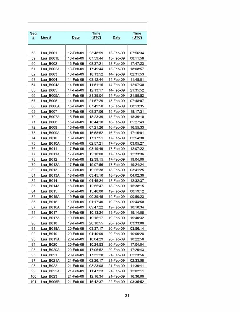
31
Seq # Line # Date
Time (UTC) Date
Time (UTC)
58 Lau_B001 12-Feb-09 23:48:59 13-Feb-09 07:56:34 59 Lau_B001B 13-Feb-09 07:59:44 13-Feb-09 08:11:58 60 Lau_B002 13-Feb-09 08:37:21 13-Feb-09 17:47:23 61 Lau_B002A 13-Feb-09 17:49:44 13-Feb-09 18:08:57 62 Lau_B003 13-Feb-09 18:13:52 14-Feb-09 02:31:53 63 Lau_B004 14-Feb-09 03:12:44 14-Feb-09 11:48:01 64 Lau_B004A 14-Feb-09 11:51:15 14-Feb-09 12:07:30 65 Lau_B005 14-Feb-09 12:13:17 14-Feb-09 21:35:52 66 Lau_B005A 14-Feb-09 21:39:04 14-Feb-09 21:55:52 67 Lau_B006 14-Feb-09 21:57:29 15-Feb-09 07:48:07 68 Lau_B006A 15-Feb-09 07:49:50 15-Feb-09 08:13:35 69 Lau_B007 15-Feb-09 08:37:06 15-Feb-09 18:17:31 70 Lau_B007A 15-Feb-09 18:23:39 15-Feb-09 18:39:10 71 Lau_B008 15-Feb-09 18:44:10 16-Feb-09 05:27:43 72 Lau_B009 16-Feb-09 07:21:26 16-Feb-09 16:55:33 73 Lau_B009A 16-Feb-09 16:58:52 16-Feb-09 17:16:01 74 Lau_B010 16-Feb-09 17:17:51 17-Feb-09 02:54:30 75 Lau_B010A 17-Feb-09 02:57:21 17-Feb-09 03:05:27 76 Lau_B011 17-Feb-09 03:19:49 17-Feb-09 12:07:22 77 Lau_B011A 17-Feb-09 12:10:00 17-Feb-09 12:33:36 78 Lau_B012 17-Feb-09 12:39:15 17-Feb-09 19:04:00 79 Lau_B012A 17-Feb-09 19:07:56 17-Feb-09 19:24:24 80 Lau_B013 17-Feb-09 19:25:38 18-Feb-09 03:41:25 81 Lau_B013A 18-Feb-09 03:45:10 18-Feb-09 04:02:30 82 Lau_B014 18-Feb-09 04:45:24 18-Feb-09 12:32:37 83 Lau_B014A 18-Feb-09 12:55:47 18-Feb-09 15:38:15 84 Lau_B015 18-Feb-09 15:46:00 19-Feb-09 00:19:12 85 Lau_B015A 19-Feb-09 00:39:45 19-Feb-09 00:50:23 86 Lau_B016 19-Feb-09 01:17:40 19-Feb-09 09:44:50 87 Lau_B016A 19-Feb-09 09:47:22 19-Feb-09 10:10:34 88 Lau_B017 19-Feb-09 10:13:24 19-Feb-09 19:14:08 89 Lau_B017A 19-Feb-09 19:16:17 19-Feb-09 19:40:32 90 Lau_B018 19-Feb-09 20:10:55 20-Feb-09 03:33:00 91 Lau_B018A 20-Feb-09 03:37:17 20-Feb-09 03:56:14 92 Lau_B019 20-Feb-09 04:40:09 20-Feb-09 10:00:28 93 Lau_B019A 20-Feb-09 10:04:29 20-Feb-09 10:22:50 94 Lau_B020 20-Feb-09 10:24:53 20-Feb-09 17:04:04 95 Lau_B020A 20-Feb-09 17:06:52 20-Feb-09 17:29:43 96 Lau_B021 20-Feb-09 17:32:20 21-Feb-09 02:23:56 97 Lau_B021A 21-Feb-09 02:26:17 21-Feb-09 02:33:58 98 Lau_B022 21-Feb-09 03:23:08 21-Feb-09 11:39:41 99 Lau_B022A 21-Feb-09 11:47:23 21-Feb-09 12:02:11
100 Lau_B023 21-Feb-09 12:16:34 21-Feb-09 16:36:00 101 Lau_B006R 21-Feb-09 16:42:37 22-Feb-09 03:35:52
32
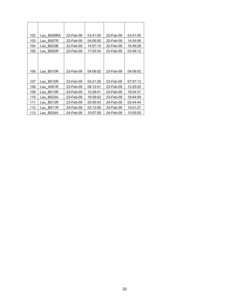
102 Lau_B006RA 22-Feb-09 03:41:05 22-Feb-09 03:41:05 103 Lau_B007R 22-Feb-09 04:06:55 22-Feb-09 14:54:06 104 Lau_B023B 22-Feb-09 14:57:15 22-Feb-09 16:49:28 105 Lau_B002R 22-Feb-09 17:03:34 23-Feb-09 03:48:12
106 Lau_B015R 23-Feb-09 04:08:02 23-Feb-09 04:08:02
107 Lau_B015R 23-Feb-09 04:21:26 23-Feb-09 07:57:13 108 Lau_A001R 23-Feb-09 08:12:41 23-Feb-09 12:25:20 109 Lau_B013R 23-Feb-09 12:28:41 23-Feb-09 19:24:37 110 Lau_B023A 23-Feb-09 19:39:42 23-Feb-09 19:44:09 111 Lau_B012R 23-Feb-09 20:00:43 24-Feb-09 02:44:44 112 Lau_B011R 24-Feb-09 03:13:59 24-Feb-09 10:01:27 113 Lau_B024A 24-Feb-09 10:07:58 24-Feb-09 15:05:05
33
Instrument Deployment Map

34
Shot Line Map – Campaign I

35
Shot Line Map – Campaign II
36
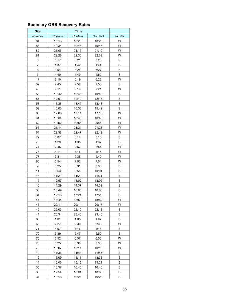
Summary OBS Recovery Rates Site Time
Number Surface Hooked On Deck SOI/W 84 18:13 18:20 18:23 W 83 19:34 19:45 19:48 W 82 21:06 21:16 21:19 W 81 22:26 22:36 22:39 W 8 0:17 0:21 0:23 S 7 1:37 1:42 1:44 S 6 3:04 3:25 3:27 S 5 4:40 4:49 4:52 S 17 6:10 6:19 6:22 W 32 7:45 7:52 7:55 S 48 9:11 9:19 9:21 W 56 10:42 10:45 10:48 S 57 12:01 12:12 12:17 S 58 13:38 13:46 13:48 S 59 15:06 15:38 15:42 S 60 17:00 17:14 17:16 W 61 18:34 18:40 18:43 W 62 19:52 19:58 20:00 W 63 21:14 21:21 21:23 W 64 22:38 22:47 22:49 W 72 0:07 0:14 0:16 S 73 1:29 1:35 1:37 S 74 2:46 2:52 2:54 W 75 4:11 4:16 4:18 W 77 5:31 5:38 5:40 W 80 6:54 7:02 7:04 W 9 8:25 8:31 8:33 S 11 9:53 9:58 10:01 S 13 11:21 11:29 11:31 S 15 12:57 13:02 13:05 S 16 14:29 14:37 14:39 S 33 15:49 16:00 16:03 S 34 17:16 17:24 17:28 S 47 18:44 18:50 18:52 W 46 20:11 20:14 20:17 W 45 22:03 22:10 22:13 S 44 23:34 23:43 23:46 S 66 1:01 1:05 1:07 S 65 2:27 2:36 2:38 W 71 4:07 4:16 4:18 S 70 5:39 5:47 5:50 S 76 6:52 6:57 6:58 W 78 8:25 8:36 8:38 W 79 10:07 10:11 10:13 W 10 11:35 11:43 11:47 S 12 13:09 13:17 13:38 S 14 15:06 15:18 15:21 S 35 16:37 16:43 16:46 S 36 17:54 18:04 18:06 S 37 19:18 19:21 19:23 S
37
Assessment of OBS Operations and Instrumentation We deployed all 59 instruments initially; we then recovered 25 and immediately redeployed them for a total of 84 deployments and recoveries. Deployments took ~10 minutes on site and on average about 30-40 minutes from station to station to complete. This was much faster than planned (1 hour + transit as per OBSIP guidelines). Recoveries also took much less time than planned, 1.5 hours from the time one instrument landed on deck to the next (as compared to the 2.5 hours + transit as per OBSIP guidelines). Overall this saved us considerable time, time which was used to make up for lost time due to hurricane Hettie and problems with the guns. The instrument handlers worked long hard hours during the deployments and recoveries and should be commended for that effort. WHOI: The WHOI D2 instrument is a small compact OBS. The sensor is decoupled from the electronics and battery package, resulting in low ocean current induced noise on the sensor. This is an indispensable feature of this instrument and all OBSIP instruments should have the geophone decoupled from the instrument body. The data was overall of very high quality with only a little instrument noise due to hard drives spinning once an hour or so (easily filtered out due to its high frequency). The usual ship noise is evident throughout much of the records. On the down side, according to the captain the radio beacon was only detectable by the bridge just off the ship’s bow. Dead flashers or heavy fog and these instruments could be lost. There were four WHOI instruments with partial recovery aides that we recovered during daylight hours. For multi-deployment experiments, obtaining data at sea is indispensable (to assess firing intervals and other data acquisition parameters). Mini-seed data was readily available from the WHOI group, but not readable by the standard rdseed software. That was unfortunate and required us to cobble together a quick shot file to get a section of segy data for analysis. If a miniseed reader was available for general use, it would have saved us some time, since we didn’t really need the shot gathered data at that point to assess the firing interval. A data viewer is not enough, since a scientist needs to be able to manipulate the data stream. Micro-seismicity in the Lau basin is high (one identifiable earthquake every ~4 minutes). This background noise appeared to be the major source of noise on the WHOI instruments. At the time of this writing a full data check has not been made, but from the preliminary analysis it seems that any self-noise of the instrument is much less than the micro-seismic noise (apart from the drive noise mentioned earlier). One ball leaked a small amount: about 1.5 pints of water including very fine sediment. The glass ball design makes it difficult to make any repairs aboard the ship. Luckily we did not need to redeploy this particular instrument. SEGY cut files are 1.7 GB each for the stations deployed the longest and are too large to use efficiently. A better method would be to have separate files for each channel. WHOI cuts the channels together, SIO cuts them out separately. It would be better for the users for both groups to do it the same way (separate files for each channel). SIO: The SIO instruments are frame-mounted devices attached to a large anchor. From an overall operational perspective, instrument recoveries and deployments were not appreciably longer or shorter than for the WHOI instruments, though the techs seemed to think otherwise. The radio beacon and flashers seem to work well for the SIO instruments.
38 20:34 20:38 20:41 S 39 22:00 22:05 22:08 S 40 23:25 23:33 23:35 S 41 0:37 0:43 0:45 S 42 1:57 2:04 2:06 S 43 3:20 3:31 3:33 S 67 4:44 4:54 4:56 S 68 6:08 6:18 6:20 S 69 7:29 7:36 7:38 S

38
Perhaps becasue the 3-component sensor is mounted to the frame and anchor, it picks up a considerable amount of current generated oscillation/noise; including a persistent ~6 and ~12 Hz “hum”, that may due to the current-induced oscillations or may be due to electronic humming, that comes and goes throughout the records depending on current speeds. Many hours of data on each instrument appear to be obliterated by this noise, because it is large enough to completely swamp the 3-component channels. Due to its very high amplitude, Butterworth band pass filtering does not remove this noise, but perhaps more exotic filtering would help.
Figure. (Possible) flag or other current-induced noise on the vertical channel.
Almost all 3-component SIO channels examined to date exhibit strong instrument noise of unknown origin
that appears as large partially-aliased spikes separated by perhaps 60 ms, and at times what looks like a 4 Hz square wave, also of significant amplitude (a 4Hz spectral line can often be observed in the spectrograms). Preliminary analysis shows reveals spiky data on almost all 3-comp. channels; we have not yet examined all records for the 4-Hz “square” wave. Neither can be effectively filtered from the data. The spikes in particular are a form of white noise that flatten the amplitude spectra of the data and make the records very ringy when high-pass filtered (filtered spikes become sinc-like functions). If the 4Hz spectral line is truly a square wave, then it too cannot be effectively filtered out by a typical bandpass or highpass procedure due to its large bandwidth. The SIO hydrophone data for the most part looks very good; it does not suffer from either the strumming problem or the instrument self-noise spike problem.
Passcal SEGY data (continuous data) was readily available from the SIO group and easily read by a psegy2mat program. This was very useful for getting a quick look at the data before re-deployment and shooting. All of the psegy continuous data and segy shot-cut data was provided on a 1TB disk to the PI at the end of the cruise. The SIO tech had to cut the data several times over several days due to missteps and mistakes in the header information and database (typos and bad math). Finding and following up on these problems was a huge waste of time for the science party and the SIO tech. Such mistakes would have been largely avoided if there was an agreed upon format for the Langseth shot log and a more careful data processing procedure.
Both Groups: A simple spec sheet with channel configuration, sensor information, and a nominal sensor response should be provided. Certain important details about the instruments were unknown by the instrument operators at sea. For example, each group records four channels, but what channel is what component of the instrument was not immediately known. Furthermore, the sign of the channels was (and still is) also unknown. Is inward pressure on the hydrophone a positive count or negative? Does the vertical component record vertical motion positive up or positive down? And what do the instruments actually record? Is it displacement, velocity, or acceleration? What about the hydrophone? Is it really pressure?

39
The two groups do not provide the same data products: the shot cut data do not have exactly the same header formats. Although different PIs may want different info in the header, all of the basic fields should be filled in and filled in the same manner. For example, SIO provides the trace start time and the shot time in different fields, because they are slightly different values, whereas the WHOI header only give the trace start time – the fact that the shot time is not exactly the same as the first sample time is lost and will generate a small amount of round-off noise in the data. Also, one group uses big-endian byte order, the other uses little-endian byte order. They should use the same. It would be very useful if OBSIP, as a group, provided a couple of different types of data readers for their data. For example, segy2mat codes for matlab are available and an official OBSIP version would be greatly appreciated. The OBSIP groups should agree upon a standard Shot Log format and then insist that the Langseth science techs provide that format and that format only. Since there is no standard, the shot log format causes considerable amounts of time to be wasted by the science and OBSIP parties (reformatting, misunderstanding of fields, etc). In addition, because the OBS staging areas and Main science labs are located far from one another, the telephone was used to send drop location information from the Main Lab to the OBS lab. This led to several typos in the OBS database of drop points and thus typos in the SEGY headers. A better system would be to have the science party compile a well-checked list of the drop points for the OBS operators.
Assessment of Ship Operations The planned experiment consisted of 77 OBS deployments along a 150 km section of the Eastern Lau Spreading Center with ~47 lines of ridge-parallel and ridge-perpendicular airgun shots to cover the area and provide seismic sources for imaging the crust and uppermost ~2 km of the mantle. Several days of contingency mapping in the western part of the basin were also planned. Several days of weather (and marine mammal) contingency were built into the cruise plan, including contingency time for both OBS operations and shooting. After passing through Cyclone Hettie that occurred just after all OBS were deployed and caused 36-48 hours of delay, we had excellent weather. A big surprise to all was that we did not encounter any marine mammals during operations and we were not delayed on that score. We were able to make ~10% greater OBS deployments (84 versus 77) and we shot ~120-125% more seismic line than planned. The A-frame winch used for OBS deployments is poorly located, being on the main deck and subject to the constant sloshing of seas over the starboard side. It shows significant rust, got stuck on us once, and may prove to cause problems down the road. Perhaps a better placement would be on the level above, with the controls at the A-frame. That would allow one operator to control both the A-frame and the winch, rather than the two operators that are currently required. The main boom/winch and the CTD winches were inoperable and we instead used a streamer capstan, a rope, and several pulleys to perform the OBS release test. This test took ~6-7 hours longer than anticipated due to the inoperable winches. During heavy seas significant water rushes over the starboard rail and could cause serious injury to OBS operators. Luckily we escaped such problems. The gunners worked long hard hours and were very dedicated to keeping the airgun array fully functional and by the end of the cruise the airgun array was working almost flawlessly, however throughout most of the shooting we had multiple gun drop outs and many timing issues that required work at the ends of most of the seismic lines and in a few cases during the lines. We did loose full volume at the ends of the lines during repairs, which was better than loosing time to gun repairs (the Chief Scientists decision). I understand that the guns had not been used for several months, a contributing factor surely, but also there didn't seem to be enough spare parts aboard the ship for full maintenance of the problems. The marine office did not have our permits fully in order to operate in Tongan waters and our permit expired 5 days before the end of the cruise forcing seismic operation to end early. This is an unbelievable oversight. The

40
party in charge assured us via email that everything was in order even though it was clear to us that it was not and he did not understand that the captain was not about to risk his license over the issue. By the time it was finally admitted that the permits were not extended to the full cruise duration, it was too late to get the necessary paper work from the Tongans. We lost ~4-5 days of seismic work because of this. Luckily for us, we had such good weather that we were already ahead of schedule and by trimming off the ends of some expected lines and not shutting down for repairs, we were able to squeeze in all of the planned seismic lines. For the extra 5 days at the end where we didn't have Tongan permits, we carried out some underway-geophysical mapping in the western basin. Pre-cruise the PI received good feedback concerning the cruise plan and science objectives from Anthony Johnson (tech in charge) and Jeff Rupert at the marine office. This feedback allowed me to redesign the experiment a bit to mesh better with the operational constraints of the ship - something that saved us much time later. The lack of full permits for the cruise window (discussed above) was clearly the low point of the cruise. The cruise was scheduled in the middle of the cyclone season for that area. We lobbied for and received 4-5 extra weather days (1/3 chance of getting hit by a cyclone during the cruise) during the pre-cruise scheduling. We did get hit by Cyclone Hettie early on and lost a couple of days, but made that up as the cruise progressed due to subsequent excellent weather and no OBS problems. In the end, those extra days meant a world of difference in getting all of the science objectives completed. The scheduling process was very opaque and as Chief Scientist I felt that I was usually last to know of schedule changes and often found out through third parties. There was a last minute rearrangement of the inbound transit leg when it was "discovered" that Tonga would not be able to provide sufficient fuel for the ship. This was something I had previously pointed out to the Lamont marine office perhaps 2 months earlier, but was ignored. I ultimately provided them with an alternative stop-over in Pago-Pago, Samoa for fuel. The marine technical party was adequately staffed with seasoned veterans (and one new tech) who worked long hard hours to make sure all of our science objectives were met. Anthony Johnson was indispensable in getting this cruise through to completion. The science party worked well together and were willing to listen to each others' (and my) comments and criticisms and effectively modified operations to be as efficient as possible. They did an excellent job of training the watch standers and an excellent job of communicating their needs, thoughts, and concerns to the Chief Scientist. There was an unexpected strong sense of common purpose to achieve the science objectives. Lamont should know that they have a very good group here and I hope that the marine office considers their comments/concerns carefully. Also, Gunners need more spare parts to keep the guns going at top performance. The marine techs should insist that OBSIP come up with an agreed-upon Standard Shot Log Format and then they should always provide that format and that format only. Since there is no standard, the shot log format changes cruise-to-cruise and causes considerable amounts of time to be wasted by the science party and the OBS party (reformatting, misunderstanding of fields, etc). Days lost at sea due to weather and equipment: 2 lost days for Cyclone Hettie, but was absorbed in contingency time. Also 1-2 hours per day lost to gun repairs, but this time was also included in our contingency time. 6-8 hours lost due to inoperable winches (used a slow streamer spool instead as noted above); this was absorbed in contingency time. 4-5 days of lost seismic shooting due to missing permits performed mapping contingency instead. ===============================================================================

41
APPENDICES
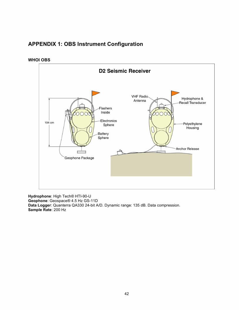
42
APPENDIX 1: OBS Instrument Configuration
WHOI OBS
Hydrophone: High Tech® HTI-90-U Geophone: Geospace® 4.5 Hz GS-11D Data Logger: Quanterra QA330 24-bit A/D. Dynamic range: 135 dB. Data compression. Sample Rate: 200 Hz

43
Scripps OBS
Hydrophone: High Tech® HTI-90-U Geophone: Mark L28 3-component geophone Data Logger: L-Cheapo 2000 (LC2000) Sample Rate: 200 Hz
Instrument Channels SIO Instruments
Channel Description Polarity Output (Volts/):
Type
0 X m/s Mark L28 1 Y m/s Mark L28 2 Z m/s Mark L28 3 HYD µPa High Tech HTI-90-U
Convention for 3-comp.
WHOI Instruments Channel Description Polarity Output
(Volts/): Type
ELZ (1) Vertical m/s Geospace 4.5 Hz GS-11D EL1 (2) North-South m/s Geospace 4.5 Hz GS-11D EL2 (3) East-West m/s Geospace 4.5 Hz GS-11D EDH (4) Hydrophone µPa High Tech HTI-90-U
Convention for 3-comp. • WHOI and presumably SIO instruments contain a two-ring Gimbals system that can be accidentally
inverted within the sensor casing. If one ring is inverted, then the vertical component is up side down. If two rings are inverted, then the vertical is correct, but the horizontals are inverted (west becomes east and north becomes south).
• Martin R. says that SIO electronics do not invert the polarity.
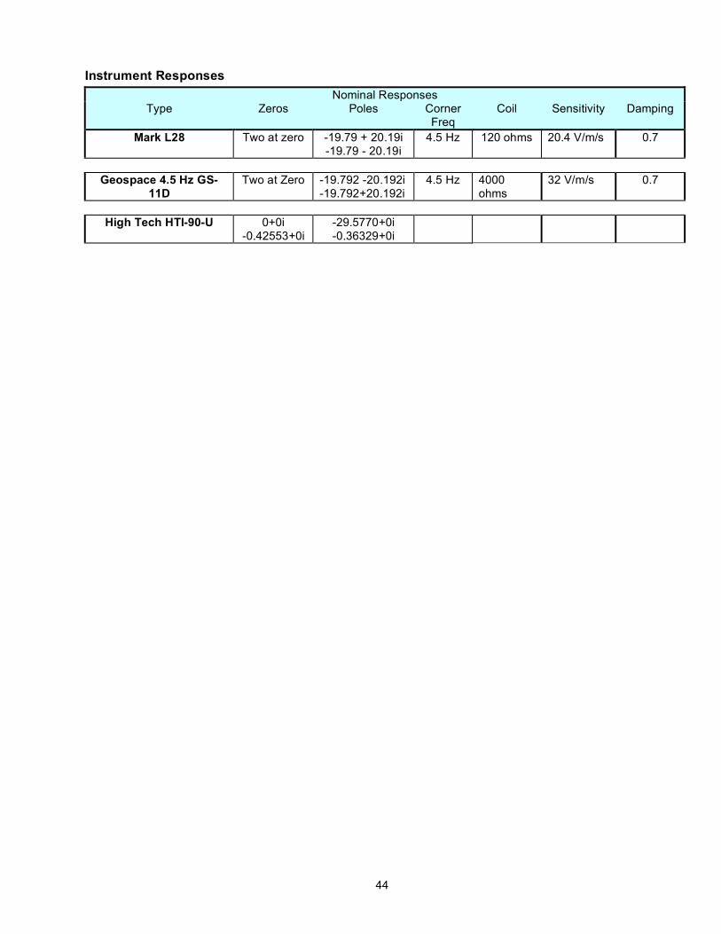
44
Instrument Responses Nominal Responses
Type Zeros Poles Corner Freq
Coil Sensitivity Damping
Mark L28 Two at zero
-19.79 + 20.19i -19.79 - 20.19i
4.5 Hz 120 ohms 20.4 V/m/s 0.7
Geospace 4.5 Hz GS-
11D Two at Zero -19.792 -20.192i
-19.792+20.192i 4.5 Hz 4000
ohms 32 V/m/s 0.7
High Tech HTI-90-U 0+0i
-0.42553+0i -29.5770+0i -0.36329+0i
45
APPENDIX 2: WHOI OBSIP Cruise Report L-SCAN experiment, Jan-Mar 2009 R/V Langseth
Summary: The Ocean Bottom Seismograph (OBS) group at the Woods Hole Oceanographic Institution
provided 20 “D2” instruments plus two spares (22 total) through the Ocean Bottom Seismograph Instrument Pool (OBSIP) in support of the “Lau Spreading Center Active source iNvestigation (L-SCAN). All deployments and recoveries, as well as the airgun work were handled from the R/V Langseth. Twenty-one D2 instruments were deployed initially. After shooting the airguns to these instruments, seventeen D2s were recovered. We then redeployed seventeen D2s at other sites further north. After another round of shooting, all 21 D2s on the bottom were recovered. In all there were 38 D2 deployments, and every one was successfully recovered and had recorded data over the entire deployment period.
The OBS group from Scripps Institute of Oceanography (SIO) was also present with 39 of their “L-CHEAPO” instruments. For deployments and recoveries, the OBSIP personnel were split into two 12-hour shifts, with at least one tech from each institution on each shift. This allowed for around the clock operations without regard to instrument type.
Deck operations: Deployments and recoveries went without major incident, using the A-frame and a temporary
electric winch to lift the instruments over the gunwale. This worked reasonably well, and was far preferable to the HIAB crane. The only major issue was that the line jumped the sheave several times. This complicated recoveries, twice forcing D2s to be hauled up by hand, and once forcing the HIAB to be used. The winch had some minor quirks and a switch failure, but fortunately these problems did not impede the recoveries. An issue that has been noted in past cruises on the Langseth is that tag lines can become jammed in the narrow gaps along the gunwale. This did not present a major difficulty, but it did require extra care and attention. The addition of cleats along the gunwale would ease the handling of tag lines. The D2s and support equipment were housed in a 20-foot lab van stored on the main deck. This is convenient for preparing instruments and debriefing them. Unfortunately, the deck is not flat, so the van twists as it is secured, jamming the double doors shut. All operations were carried out through the side door. There are times when being able to open the rear doors would be beneficial. A GPS antenna and an Iridium satellite phone antenna were mounted to the rails on the streamer deck when the ship was in port in Astoria, Oregon. These provide signals to the interior of the van. Upon arrival in Tonga, the GPS signal was weaker in the van than when it had left Astroia. A basket of gas canisters had been secured to the rail where the GPS antenna was located. This both partially blocked the view of the sky and crushed the antenna cable. The antenna was moved over away from the basket, and the cable was re-terminated after removing the damaged section. The GPS signal improved after this.
Recoveries: The D2s and L-CHEAPOs use the same acoustic release system, made by Edgetech/ORE, to
dissolve a burnwire and drop an anchor to release the instruments. Thus both groups used the same model 8011A acoustic deck box and hull-mounted transducer to communicate with their instruments. There were no major problems with the releases. In several cases the replies from the ocean bottom were inaudible, but the instruments clearly received and responded to all commands, releasing as expected. Once the instrument had released the reply signals became clearly audible. This problem was common to both the D2s and L-CHEAPOs. This is likely a function of the makeup of the ocean floor. A few D2s needed multiple commands to be sent before they were successfully received and acknowledged. In all cases, the instruments dropped their anchors within the 15 minutes of confirming the first release command. No repeat burns were required. Spotting the instruments generally

46
happened quickly once they were on the surface. The D2s have a very low surface profile, and thus are more difficult to spot than the L-CHEAPOs. The addition of a fluorescent orange flag to the D2s on this cruise increased their visibility significantly compared to previous cruises. The D2s are equipped with a radio beacon, to alert the bridge to their presence on the surface and ideally to allow for a Radio Direction Finder (RDF) to assist in locating the instrument. On most vessels this works well. However, on the Langseth, the RDF on the bridge was unable to detect the radio beacons until they were within about 100 meters, after they had already been spotted.
Water leak in D51: The only major D2 instrument issue was a water leak in number D51, which was deployed at site
#48 over both halves of the experiment. The main 17” glass ball, which houses essentially all the electronics, took on roughly a pint of water. The water had caused the instrument to shut down during the recovery process, so normal debrief was not possible. The ball was opened as soon as possible and all components were removed, cleaned and dried. Luckily damage was minor considering the quantity of water involved. While some neighboring components were severely corroded, the 2.5” hard drive itself was unharmed. By installing the hard drive into a spare baler, data were retrieved for the entire deployment up until the last half hour before recovery. The offset of the internal clock to UTC was not captured at recovery. The drift rate had to be inferred by comparing shots that had fallen at the same locations but at different times. Using this drift rate and the pre-deployment clock offset the data were clock corrected appropriately.
Data quality: Data were recovered from all 38 D2 deployments, and analyzed preliminarily using Cimarron, a
proprietary M-SEED viewer from Quanterra, the designer of the data loggers used in the D2s. There are no gaps in data on any of the instruments. In a few cases one of the horizontal channels of the geophone showed a low signal level compared to the other two channels on the same instrument and compared to the rest of the instruments. This is a somewhat subjective observation, and the shots are all clearly visible, so this may prove to be inconsequential. The only case where shots are not visible at all is channel EL1 on D03 deployed at site #83. The other two geophone channels and the hydrophone all look fine. See the attached spreadsheets for a summary of the performance of each channel on each deployment. A particular type of noise was observed in data from many of the instruments. This noise occurred at intervals from 1 to 8 hours (depending on the buffer size of the data logger and the amount of compression applied), each time the baler (hard drive) in the instrument turned on. It manifests as several bursts of a signal at 70Hz lasting for several seconds each over the course of a few minutes. In some cases impulses with low frequency ringing and noise spikes accompany these 70Hz bursts. These noise spikes reach amplitudes in excess of 10000 counts in a few instruments. The character of the noise for each instrument seems to be fairly consistent over the course of a deployment, although there were a few that changed over the deployment. According to personal communications with the chief scientist these noise bursts are easily distinguished from any real seismic event, and so should pose little to no problem in data processing. If necessary the times of these events can be predicted accurately for each instrument to aid processing. The attached spreadsheets also contain a brief description of the character of the baler turn-on noise. With the exception of D51 (see “Water Leak”, above), data from all instruments were clock corrected using offsets obtained at the beginning and end of the deployments by comparing the time of the internal Seascan real time clocks to the internal GPS receivers of the instruments. The data were then processed into SEGY format.

47

48
APPENDIX 3: Assessment of Background Noise and Firing Interval
Shot numbers 1:120 and 121:240 in the SEGY records are fake shot numbers with times for when the airguns were no longer firing. The records occur every 60 s and the data is cut with 60 s traces, so these records constitute two x two-hour blocks of shot-free data, with the exception that in both cases the last shot of Campaigns I and II occurs only a few minutes into these two blocks. Therefore, one can examine the ring-down of the seismic source unimpeded by following shots.
Figure. Station 49 (deployment 1). Last shot. Station is located ~8km from the shot.

49
Figure. Station 49 (deployment 1). RMS amplitude (RMS of 10 point window) of last shot. Station is located
~8km from the shot.
Figure. Station 04 (deployment 1). RMS amplitude (RMS of 10 point window) of last shot. Station is located
~38km from the shot. For a station located 8 km from the source, the time for the shot noise to dissipate is ~140 s after the first arrival. For a station located 38 km from the source, the time for energy dissipation is ~180 s after the first arrival. For stations >38 km from the source, one should consider 210 s shot intervals or larger. APPENDIX 4: Marine Mammal Observation Summary No marine mammals (or turtles) observed during the airgun operations. One green turtle sited during post-seismic mapping phase (March 3). Small pod of pilot whales spotted on transit to port. A search for large baleen whale calls in the OBS data returned nothing.
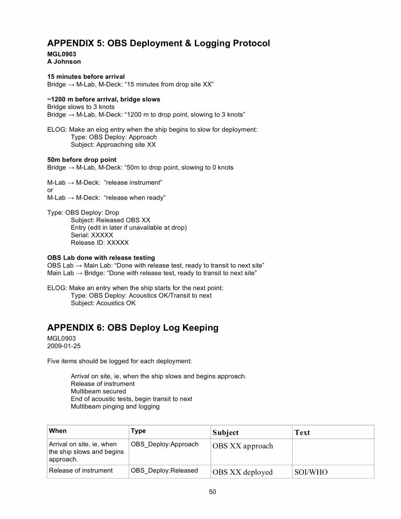
50
APPENDIX 5: OBS Deployment & Logging Protocol MGL0903 A Johnson 15 minutes before arrival Bridge → M-Lab, M-Deck: “15 minutes from drop site XX” ~1200 m before arrival, bridge slows Bridge slows to 3 knots Bridge → M-Lab, M-Deck: “1200 m to drop point, slowing to 3 knots” ELOG: Make an elog entry when the ship begins to slow for deployment: Type: OBS Deploy: Approach Subject: Approaching site XX 50m before drop point Bridge → M-Lab, M-Deck: “50m to drop point, slowing to 0 knots M-Lab → M-Deck: “release instrument” or M-Lab → M-Deck: “release when ready” Type: OBS Deploy: Drop Subject: Released OBS XX Entry (edit in later if unavailable at drop) Serial: XXXXX Release ID: XXXXX OBS Lab done with release testing OBS Lab → Main Lab: “Done with release test, ready to transit to next site” Main Lab → Bridge: “Done with release test, ready to transit to next site” ELOG: Make an entry when the ship starts for the next point: Type: OBS Deploy: Acoustics OK/Transit to next Subject: Acoustics OK
APPENDIX 6: OBS Deploy Log Keeping MGL0903 2009-01-25 Five items should be logged for each deployment:
Arrival on site, ie, when the ship slows and begins approach. Release of instrument Multibeam secured End of acoustic tests, begin transit to next Multibeam pinging and logging
When Type Subject Text Arrival on site, ie, when the ship slows and begins approach.
OBS_Deploy:Approach OBS XX approach
Release of instrument OBS_Deploy:Released OBS XX deployed SOI/WHO

51
Lat: XX XX.XXX Long: XXX XX.XXX Depth: XXXX m
Turn multibeam off Multibeam Multibeam secured Secured for acoustics ops
End of acoustic tests, begin transit to next
OBS_Deploy:Disabled Transit to next Acoustics OK
Turn multibeam on Multibeam Multibeam pinging and logging
Additional comments on speed or meters to/from site may be useful. Note also anything anomalous or unusual.
APPENDIX 7: Line Change Orders MGL0903 Line Change Orders, v 1.0 2009-01-30 A. Johnson Bridge should notify 30 mins before wheel over point. Alert Watch Leader at this time. Bridge will also notify before turn begins. Coming off line In Spectra, find the Line Control windows on the lower left screen. Watch the helmsman display on the left
side of the lower right screen. Watch the Velocity Along Track (VA) on the spectra display. Once VA drops below three you must end
the line and either begin the next or switch to internal cycle. If guns are pulled early for maintenance, or the source is otherwise degraded, log a separate LGSP entry in
ELOG: Type LGSP Subject <linename> LGSP XXXX Text Why no longer good (eg. “Air leack S4,
picking up for repair ” ) Note EOL in ELOG: Type EOL Subject EOL <linename> SP XXXX Text After disabling shooting, go to the Digishot system and switch to internal triggers. Set the shot cycle to 20s.
Enable the spare guns (one at a time). NOTE THE DIGISHOT GUN CONFIG BEFOREHAND. Nav Logs Update and close out the Nav Line Log. Update and sabve the Nav Sequence Log. Create and fill out a new Nav Line Log for the next line. Observer Logs Update and close out the Observer Line Log. Update and save the B15 Log. Create and fill out a new Observers Line Log for the next line. Update the Line Board

52
Prepare the Spectra Line Control Node Select the next line (right-click on the line name). Update sequence number (right next to line name). Sequence numbers should always increment
when changing lines. Update shot number: first shot should be sequence x 1000 + 21. eg. for sequence 7 first shot should be 7021. make sure 20 run-in and 0 run-out shots are configured Make sure shot type is DAlong Track. Make sure interval is 500 meters Make sure the line is going in the right direction. Reverse line if necessary. Make sure beneath the ENABLED/DISABLED button “Online and Approach ” is selected. Prepare the shotlog Switch to the NavLog workspace on spectra1 Close the nav log. Click 'setup' and select the new line. When coming on to line Turn off the spare guns in Digishot. As the ship approaches the line, watch the velocity along track. Velocity along track (VA) should be 3.0
knots or better before enabling. Prepare Digishot Set Digishot for external triggers. Set Digishot to shooting mode. Enable shooting in Spectra Note approach in ELOG Type SOL Subject SOL <linename> FSP XXXX Text FSP XXXX If not the same as SOL, note FGSP in ELOG: Type FGSP Subject <linename> FGSP XXXX Text FGSP XXXX Update and save the Nav and Observer logs, and the B15.
APPENDIX 8: Local and Global Earthquakes Occurring during the OBS experiment FILE CREATED: Wed Mar 4 02:42:50 2009 Global Search Earthquakes= 12 Catalog Used: PDE Date Range: 2009/01/24 to 2009/02/28 Magnitude Range: 6.0 - 10.0 Data Selection: Preliminary Data Only CAT YEAR MO DA ORIG TIME LAT LON DEP MAGNITUDE PDE-Q 2009 01 24 012839.35 -28.25 -176.70 10 6.0 PDE-Q 2009 02 02 175321.77 -13.58 -76.53 21 6.0 PDE-Q 2009 02 09 140902.93 -6.57 -81.12 15 6.0 PDE-Q 2009 02 11 173450.66 3.90 126.40 20 7.2 PDE-Q 2009 02 11 182511.60 4.03 126.78 35 6.0 PDE-Q 2009 02 12 034939.73 3.93 126.40 26 6.0 PDE-Q 2009 02 12 131507.43 4.05 126.57 35 6.3 PDE-Q 2009 02 15 100449.30 -5.87 -80.91 21 6.1 PDE-Q 2009 02 17 033054.45 -30.82 -178.64 13 6.0 PDE-Q 2009 02 18 215345.23 -27.44 -176.33 25 6.9 PDE-Q 2009 02 22 174522.53 3.68 126.56 32 6.0
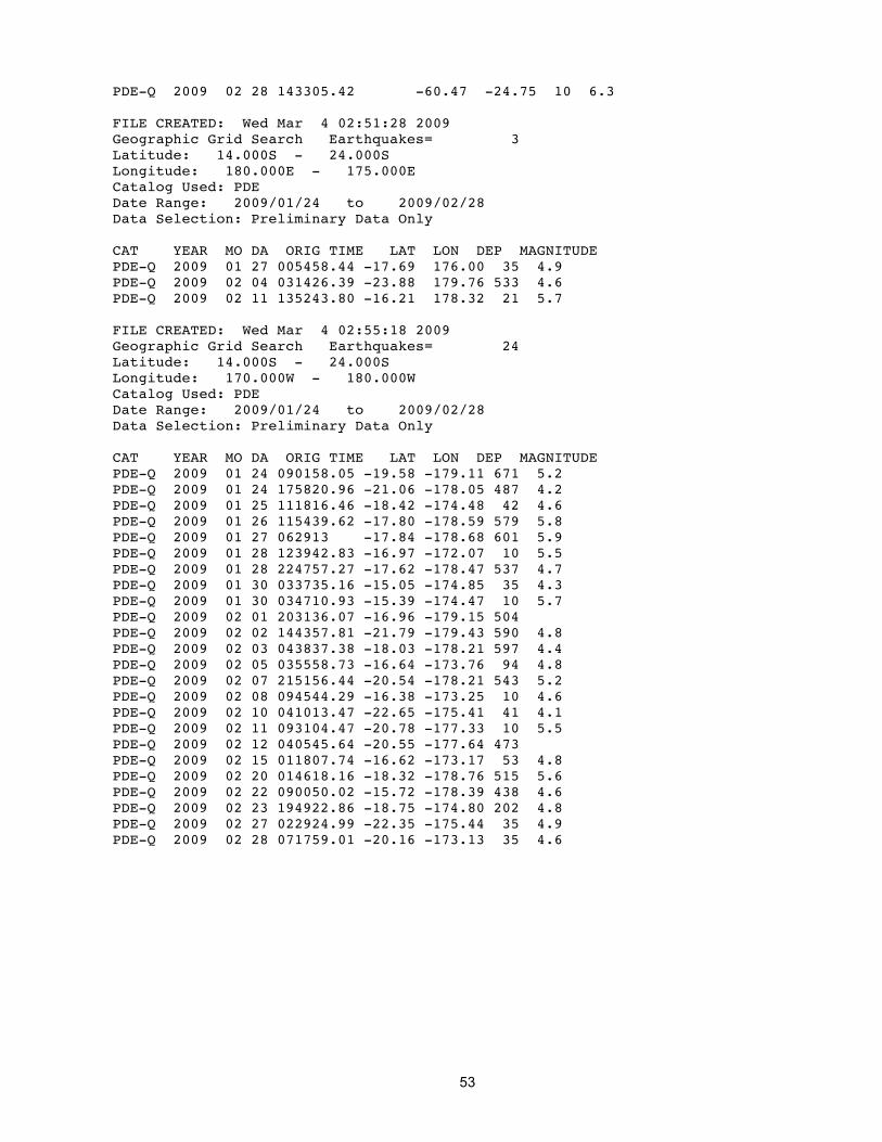
53
PDE-Q 2009 02 28 143305.42 -60.47 -24.75 10 6.3 FILE CREATED: Wed Mar 4 02:51:28 2009 Geographic Grid Search Earthquakes= 3 Latitude: 14.000S - 24.000S Longitude: 180.000E - 175.000E Catalog Used: PDE Date Range: 2009/01/24 to 2009/02/28 Data Selection: Preliminary Data Only CAT YEAR MO DA ORIG TIME LAT LON DEP MAGNITUDE PDE-Q 2009 01 27 005458.44 -17.69 176.00 35 4.9 PDE-Q 2009 02 04 031426.39 -23.88 179.76 533 4.6 PDE-Q 2009 02 11 135243.80 -16.21 178.32 21 5.7 FILE CREATED: Wed Mar 4 02:55:18 2009 Geographic Grid Search Earthquakes= 24 Latitude: 14.000S - 24.000S Longitude: 170.000W - 180.000W Catalog Used: PDE Date Range: 2009/01/24 to 2009/02/28 Data Selection: Preliminary Data Only CAT YEAR MO DA ORIG TIME LAT LON DEP MAGNITUDE PDE-Q 2009 01 24 090158.05 -19.58 -179.11 671 5.2 PDE-Q 2009 01 24 175820.96 -21.06 -178.05 487 4.2 PDE-Q 2009 01 25 111816.46 -18.42 -174.48 42 4.6 PDE-Q 2009 01 26 115439.62 -17.80 -178.59 579 5.8 PDE-Q 2009 01 27 062913 -17.84 -178.68 601 5.9 PDE-Q 2009 01 28 123942.83 -16.97 -172.07 10 5.5 PDE-Q 2009 01 28 224757.27 -17.62 -178.47 537 4.7 PDE-Q 2009 01 30 033735.16 -15.05 -174.85 35 4.3 PDE-Q 2009 01 30 034710.93 -15.39 -174.47 10 5.7 PDE-Q 2009 02 01 203136.07 -16.96 -179.15 504 PDE-Q 2009 02 02 144357.81 -21.79 -179.43 590 4.8 PDE-Q 2009 02 03 043837.38 -18.03 -178.21 597 4.4 PDE-Q 2009 02 05 035558.73 -16.64 -173.76 94 4.8 PDE-Q 2009 02 07 215156.44 -20.54 -178.21 543 5.2 PDE-Q 2009 02 08 094544.29 -16.38 -173.25 10 4.6 PDE-Q 2009 02 10 041013.47 -22.65 -175.41 41 4.1 PDE-Q 2009 02 11 093104.47 -20.78 -177.33 10 5.5 PDE-Q 2009 02 12 040545.64 -20.55 -177.64 473 PDE-Q 2009 02 15 011807.74 -16.62 -173.17 53 4.8 PDE-Q 2009 02 20 014618.16 -18.32 -178.76 515 5.6 PDE-Q 2009 02 22 090050.02 -15.72 -178.39 438 4.6 PDE-Q 2009 02 23 194922.86 -18.75 -174.80 202 4.8 PDE-Q 2009 02 27 022924.99 -22.35 -175.44 35 4.9 PDE-Q 2009 02 28 071759.01 -20.16 -173.13 35 4.6
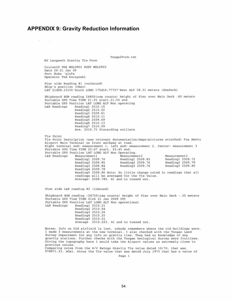
54
APPENDIX 9: Gravity Reduction Information

55
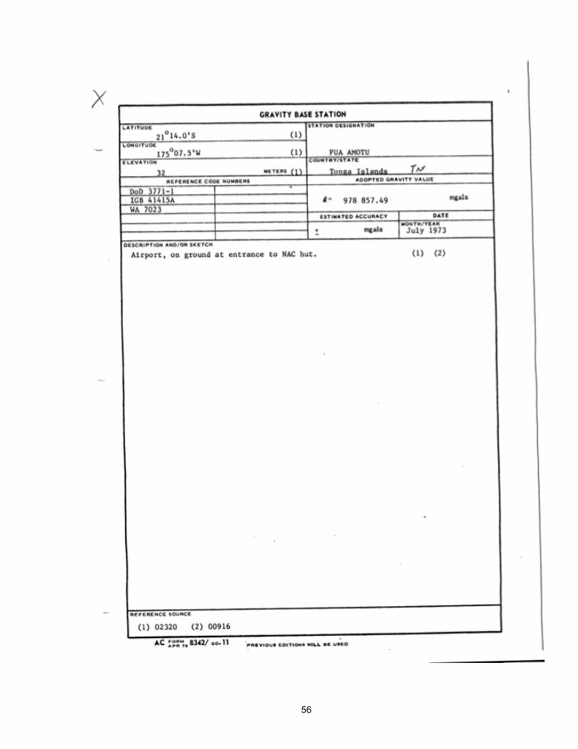
56

57
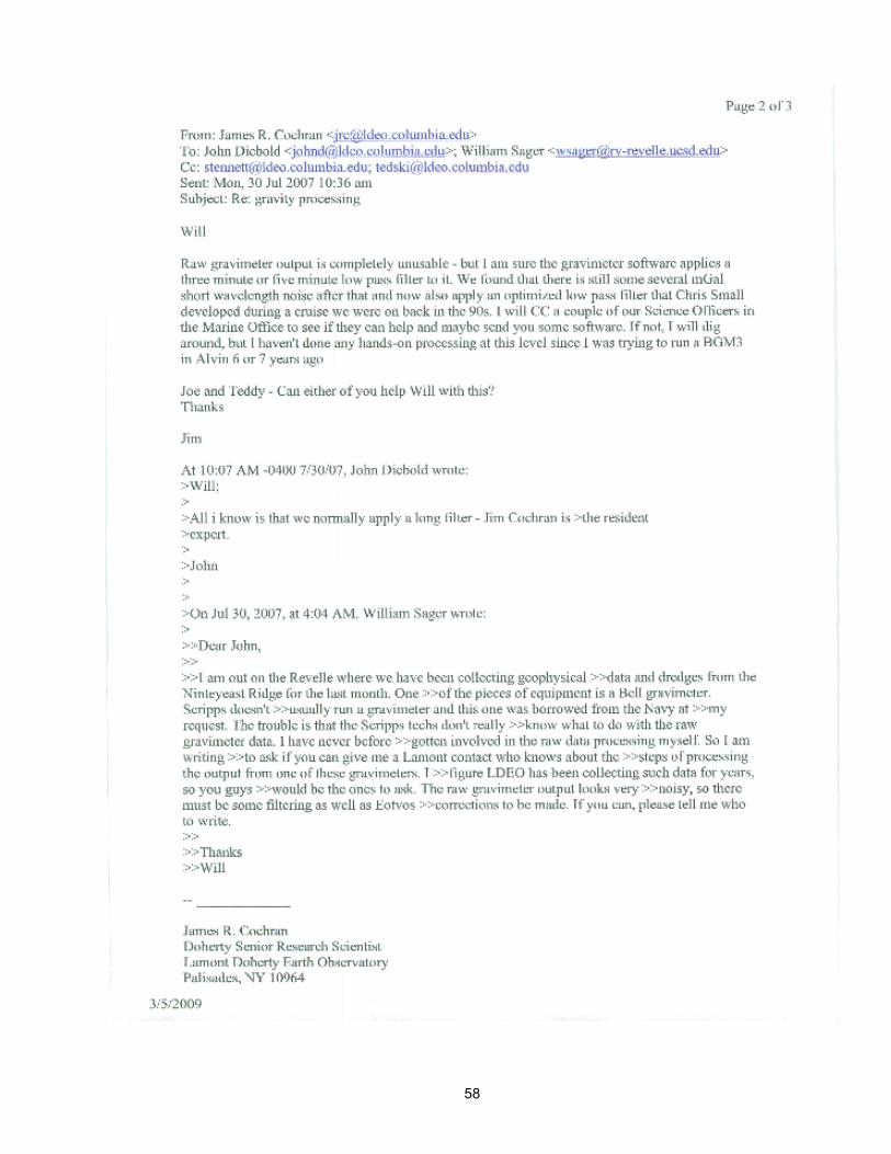
58

59
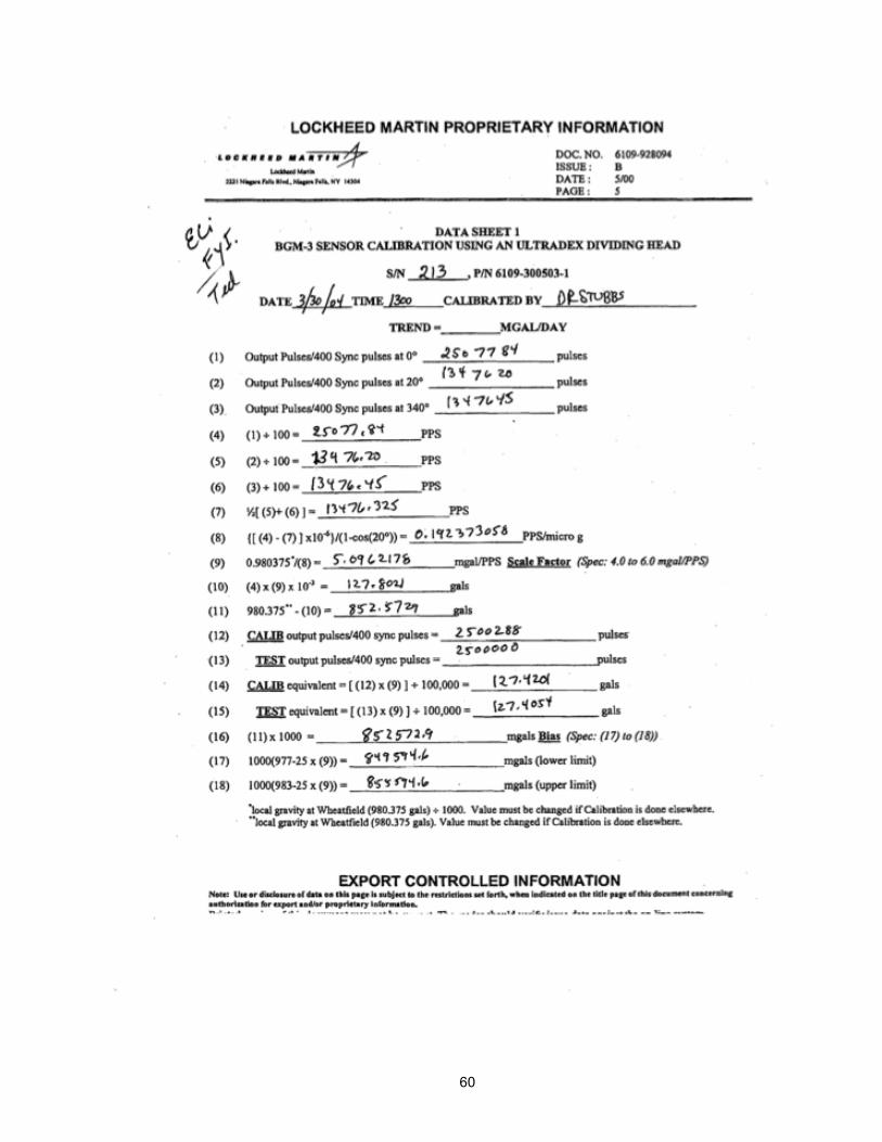
60
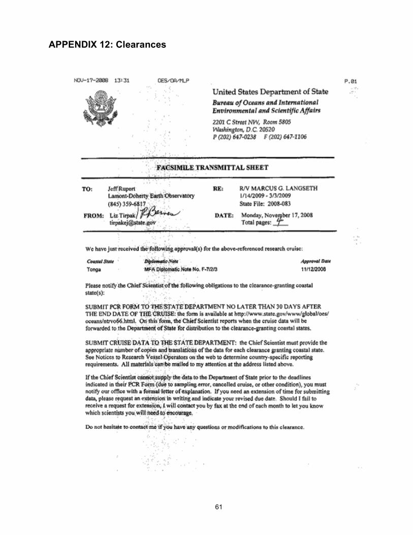
61
APPENDIX 12: Clearances
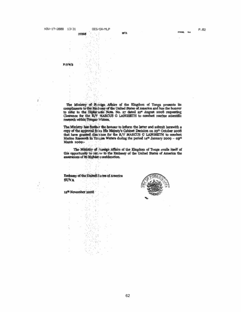
62

63

64
65

66

67