kuip ers, mit-ai tr-418, 1977
TRANSCRIPT

Representing Knowledge of Large-Scale Space1
Benjamin Jack Kuipers
July 1977
1B. J. Kuipers. 1977. Representing Knowledge of Large-Scale Space. M.I.T.
Arti�cial Intelligence Laboratory Technical Report 418. This report describes re-
search done at the Arti�cial Intelligence Laboratory of the Massachusetts Institute
of Technology. Support for the laboratory's arti�cial intelligence research is pro-
vided in part by the Advanced Research Project Agency of the Department of
Defense under O�ce of Naval Research contract N00014-75-C-0643. Revised ver-
sion of a dissertation submitted to the Department of Mathematics on May 5, 1977
in partial ful�llment of the requirements for the degree of Doctor of Philosophy.

Kuipers, MIT-AI TR-418, 1977. i
ABSTRACT
This dissertation presents a model of the knowledge a person has about thespatial structure of a large-scale environment: the \cognitive map." Thefunctions of the cognitive map are to assimilate new information about theenvironment, to represent the current position, and to answer route-�ndingand relative-position problems. This model (called the TOUR model) ana-lyzes the cognitive map in terms of symbolic descriptions of the environmentand operations on those descriptions.
Knowledge about a particular environment is represented in terms ofroute descriptions, a topological network of paths and places, multiple framesof reference for relative positions, dividing boundaries, and a structure ofcontaining regions. The current position is described by the \You Are Here"pointer, which acts as a working memory and a focus of attention. Oper-ations on the cognitive map are performed by inference rules which act totransfer information among di�erent descriptions and the \You Are Here"pointer. The TOUR model shows how the particular descriptions chosen torepresent spatial knowledge support assimilation of new information fromlocal observations into the cognitive map, and how the cognitive map solvesroute-�nding and relative-position problems.
A central theme of this research is that the states of partial knowledgesupported by a representation are responsible for its ability to function withlimited information or computational resources. The representations in theTOUR model provide a rich collection of states of partial knowledge, andtherefore exhibit exible, \common-sense" behavior.
Name and Title of Thesis Supervisor: Marvin Minsky, Donner Professorof Science in the Electrical Engineering and Computer Science Department.

ii
ACKNOWLEDGEMENTS
I would like to thank Marvin Minsky, my thesis advisor, for the inspiration,ideas, and advice he provided during this project. He, Seymour Papert,and Carl Hewitt acted as the perfect thesis committee for me. I am alsovery grateful to Dan Bobrow for suggesting this problem. A number ofpeople read early reports of this research and provided helpful comments.They include David Marr, Kevin Lynch, Shep White, and Mark Je�ery.Continuing discussions with Al Stevens have been pleasurable and helpful.My wife Laura and the rest of my household prevented when possible, andtolerated when not, the single-mindedness that goes with writing a thesis. Iam grateful to them all.
The MIT Arti�cial Intelligence Laboratory provides a unique atmosphereof intellectual excitement and enjoyment which has been very important tome. Many of the ideas in this research would not have happened without theAI Playroom. The metropolitan Boston area deserves my thanks for its ge-ography, without which this research would have been impossible. Boston'sconfusing street pattern highlights the partial knowledge of which spatialrepresentations are capable. I also appreciate the patience of the people Iinterviewed, whose confusions and impressions I attempt to describe.
I am also grateful for �nancial support provided by graduate fellowshipsfrom the National Science Foundation and the Danforth Foundation, andfor a research assistantship at the Arti�cial Intelligence Laboratory.
(November 1998.) This document has been converted to LaTeX anda few typos have been corrected, but I have resisted the temptation tomake technical or presentational changes in light of subsequent work. It isavailable as ftp.cs.utexas.edu/users/qsim/papers/Kuipers-PhD-77.ps.gz.

Contents
1 Describing Spatial Knowledge 1
2 The Tour Machine 13
3 Orientation 39
4 Dividing Boundaries 55
5 Regions 69
6 Relations to Other Work 85
7 Conclusions 93
A Descriptions of Environment, Current Position,
and Route 107
B Inference Rules 113
C Implementing descriptions 123
iii
Chapter 1
Describing Spatial Knowledge
\Puluwat is one of a long chain of islands covering over a thou-sand miles of the Paci�c Ocean north of New Guinea. The sail-ing canoe is at the very heart of the Puluwat way of life, andskilled navigators occupy the positions of highest status. Thereis quite a bit of drinking among men of Puluwat. A trip toPikelot island, one mile wide and over 100 miles distant, is of-ten launched at a drinking party. Someone jumps up and says,\I'm going to Pikelot. Who's coming with me?" The navigatordetermines his sailing plan only after he is at sea; at no timeis an overall plan developed for the voyage. Yet, without fail,at an average speed of 4.5 knots, the 26-foot sailing canoe witha now-sober crew arrives two days later at a one-mile wide is-land in the open ocean (Gladwin 1970). What is the nature oftheir knowledge about the sea and the sky and the islands andthe canoe that makes this possible?
Most mornings every reader of this paper will �nd his way to theo�ce, less exuberantly than the voyagers of Puluwat but no lessdecisively. He or she will walk, ride a bicycle, take the train, ordrive. The route may be long or short, simple or complex; it maybe interrupted or accomplished around diversions. What systemof habits, schemes, imageries, long- or short-term memories al-lows him to accomplish this?
Most mornings, thousands of 6-year-old children will �nd theirway to school. There will be protections along the way|street-crossing policemen|but there will be little fear on anyone's partthat the children will get lost. The children will �nd their way tothe school building, within the building to their classroom, and
1

2
after school, perhaps, to a friend's house. However, most 3-year-olds do not typically engage in the same process. Is it that theyare incapable of following routes and will thus get lost? It is quitepossible that these very young children can recognize landmarksin a large-scale terrain, but have limited `route-knowledge,' andthat adults are aware of this."
[Siegel and White, 1975, p. 10.]
What the Puluwat navigator, the morning commuter, and the kindergartenchild have in common is that they �nd their way without aid of maps orinstruments in a space that is too large to be perceived at once. Peoplenavigate in these circumstances by using their common-sense knowledge ofspace: they link many separate observations into a \cognitive map" andsolve route-�nding problems by consulting the knowledge in the cognitivemap.
The term \cognitive map" as used here refers to a body of knowledgethat a person has in his head about the spatial structure of an environment.This is to distinguish it from other related concepts, such as the expression ofthat knowledge as maps, models, or verbal directions. People also associatevisual impressions or social facts with di�erent parts of the environment, butthose are not the structural aspects of the cognitive map that will concernus here.
The cognitive map is used to solve route-�nding and relative locationproblems in a large-scale space. A large-scale space is de�ned by the wayit is perceived, not by its physical size. Its structure is deduced from anumber of observations over time, rather than being perceived from onelocation. The places, paths and routes of a city are the most common large-scale space in most people's experience, although of course there are others:ocean, jungle, and open �eld.
A basic assumption of this research is that knowledge, and the cognitivemap in particular, can be viewed as a complex symbolic description whichcan perform a certain range of computations. At the lowest, functional level,a person's cognitive map can be considered as a black box that receivesinputs describing actions and observations, and can solve route-�nding andrelative location problems. At the next level, the cognitive map is a learningmachine: the contents of the black box, and its ability to solve problems,change as a result of the inputs it receives. At an even higher level, theability of the cognitive map to assimilate new information changes slowlyover time. These three levels of activity correspond to problem-solving,learning, and development in humans.

Kuipers, MIT-AI TR-418, 1977. 3
The research reported here deals with the cognitive map seen as a func-tional problem-solver and as a learning machine. In order to describe itsproperties as a learning machine, we must describe the contents of the blackbox and how they change in reaction to the inputs. The result of this re-search is the TOUR model: a computational model of the cognitive map,showing how it assimilates new information and solves problems.
Mini-theories
The TOUR model is derived from a number of simple \mini-theories," eachof which captures some of the properties of the cognitive map, but noneof which is adequate to explain the whole. Each one can act as a valuablemetaphor for some aspects of spatial knowledge. In order to construct acomprehensive model, it is useful to examine the strengths and weaknessesof each one.
The \Map in the Head" theory says that the cognitive map is isomorphicto a printed map which can be examined with the \mind's eye." A verysimilar theory says that the position of a place amounts to its Cartesiancoordinates in a global grid. Learning in such a theory presumably occursby \drawing" new places and paths onto the map. These theories are easilyrefuted by anecdotal evidence about the states of partial knowledge of whichpeople capable. A two-dimensional map (on paper or in the head) providesa single global frame of reference for relative positions: two vectors, howeverremote, can be compared. This is clearly not the case for people, who oftenknow two sets of relative positions that they are unable to compare.
The \Patchwork Map" theory says that the cognitive map consists ofa number of di�erent maps, of di�erent regions and at di�erent levels ofdetail, each of which is isomorphic to a printed map. This theory avoids theproblem of global consistency of relative positions, but begs the question ofhow an appropriate map is selected when needed. It also fails to capture avery important kind of partial knowledge of relative position: the relation ofa place to a dividing boundary. (See Chapter 4) These di�culties aside, the\Patchwork Map" theory is actually a very good mini-theory of cognitivemaps. Chapter 3 discusses the way relative positions are de�ned with respectto distinct frames of reference, and Chapter 5 discusses the way appropriateregional views are selected when needed. Of course, each of these aspects ofthe TOUR model needs additional computational mechanisms which couldnot be provided by a printed map.
The \Street Network" theory says that a geographical area can be repre-

4
sented topologically as a network of nodes and arcs. A route-�nding problemcan then be stated as a \Traveling Salesman" problem, for which uniformalgorithms exist. However, the distinction between easy and hard prob-lems is quite di�erent for such uniform algorithms and for people. Further-more, many kinds of important common-sense spatial knowledge (e.g. asense of direction) cannot be supported by a topological network. Theseare the kinds of spatial abilities addressed by the previous theories. Likethe \Patchwork Map" theory, the \Street Network" theory is actually quitea good mini-theory of cognitive maps: much common-sense knowledge ofspace is a topological description of paths and places. Chapter 2 discussesthe topological aspects of the TOUR model, and shows how the place andpath descriptions di�er from the graph-theoretical concepts of node and arc.
The \Hybrid Model" theory points out that if each is a good mini-theory, then perhaps some sort of hybrid of the \Street Network" theorywith the \Patchwork Map" theory would be correct. That is the assumptionof this research, and the TOUR model is exactly such a hybrid. The processof expanding such a suggestion into a complete theory, however, requiresextensive elaboration, as demonstrated in the rest of this thesis.
The \Assertional Database" theory says that geographical knowledge isrepresented as a database of atomic assertions of geographical facts. The\Semantic Network" theory says that it is represented as clusters of labeledpointers to other clusters. These are not actually theories of knowledge atall, but only suggested implementations for databases. They omit the actualdescriptions that are in either kind of database, and the actual inferenceswhich operate on them. Either suggestion may be presented as a usefulmethod to arti�cial intelligence, for representing certain kinds of knowledge,but neither is a theory of spatial knowledge.
The \Urban Environment" objection is that the TOUR model is ex-pressed in terms that are appropriate to city streets and intersections, butit would not apply to signi�cantly di�erent large-scale environments such asforests or open ocean. This objection can only be settled conclusively by fur-ther research. However, a review of what literature does exist on non-urbanlarge-scale spaces suggests that the same descriptions apply. For example,see Gladwin (1970) for an analysis of the knowledge held by navigators inthe South Paci�c. Surprisingly, the apparently trackless ocean is seen bythe experienced navigator as covered with paths and landmarks, real andimaginary, which guide him to his destination. Similarly, Lynch (1960) re-ports that experts familiar with trackless deserts or impenetrable jungles seethem as covered with intersecting paths.
Kuipers, MIT-AI TR-418, 1977. 5
Large-scale space
Large-scale space is de�ned by the perceptual mechanisms for exploring thespace, rather than by its physical size. A large-scale space is de�ned as aspace which cannot be perceived at once: its global structure must be derivedfrom local observations gathered over time. For example, a drawing is alarge-scale space when viewed through a small movable hole, while a city canbe small-scale when viewed from an airplane. The typical operation whenlearning about a large-scale space is to compare the current observationswith the corresponding descriptions in the cognitive map. This requiresestablishing and maintaining a correspondence between the two sources ofinformation, so that information from each source can be added to the other.Much of the meaning of an observation depends on the context provided bythe cognitive map; conversely, the cognitive map is created by assimilatingmany observations.
Large-scale space is characterized by a very clear distinction betweenlocal observations and global structure. An important consequence of thisis that local descriptions are likely to be much more accurate than globalones, a phenomena which is easy to observe in people's cognitive maps. Localinconsistencies are easy to detect and correct, and can usually be attributedto particular observations. Global inconsistencies, however, are much moredi�cult to pin down, and are usually due to the unwarranted extensionof local observations. The TOUR model shows how local observations areextended to describe global structure, but it does not address the problemof debugging the cognitive map when errors are found.
Spatial knowledge is a good example of the more general category ofcommon-sense knowledge, which is characterized by easy and exible ap-plication to situations with low-quality data and limited computational re-sources. Common-sense knowledge makes it possible to take a rough de-scription of a problem and produce a correspondingly rough, but potentiallyre�nable, solution. In order to have the exibility of common-sense knowl-edge, a representation must support a rich collection of states of partialknowledge that can be meaningfully operated on. The goal of this researchis to show that a certain collection of representations, because of their abil-ities to represent partial knowledge, can describe common-sense knowledgeof space.
Spatial knowledge is a particularly fundamental kind of common-senseknowledge, for spatial metaphors are very common in representing otherkinds of knowledge. For example, time is often seen as a linear spatial di-mension, similarity is often judged as \near" and \far," and social relations

6
can be described in terms of \close," \distant," \above," and \below." Spa-tial knowledge is also universal in that it is acquired by people in all culturesand environments, and even by most animals.
The kind of spatial knowledge which is the domain of this research isthe overall structural description of large-scale space which results from as-similating local observations. This must be distinguished from the relatedproblems of communicating such knowledge among people, either throughprinted maps or verbal description. Any detailed theory of map reading ormap drawing, or the ability to give or understand verbal route instructions,must depend on a theory of how the knowledge is represented internally.Similarly, any detailed theory of the development of spatial abilities in chil-dren requires a way to describe what those abilities are at any given time.
Visual input is very important to the cognitive map, of course. It typ-ically provides the local observations which are merged into the structuraldescriptions. Visual memory permits the recognition of landmarks as be-ing the same on di�erent encounters. Without recognizing the identity ofplaces, there can be no cognitive map, because no experience relates to anyother. On the other hand, the structural descriptions of large-scale spaceare quite distinct from the visual descriptions of a scene. The TOUR modelfactors out the issues of visual input and recognition, and concentrates onhow the local structural information thus provided is assimilated into a use-ful cognitive map. The simpli�ed inputs it receives consist of topologicalconnections, estimated magnitudes of turns and travels, and the egocentricheading and distance of observed remote landmarks. These are presented inmore detail in chapters 2 and 3.
The TOUR model
The TOUR model includes a number of representations for di�erent kinds ofspatial knowledge. They fall into three initial categories: 1) representationsfor knowledge about a particular environment, 2) the description of thecurrent position, and 3) the inference rules that manipulate knowledge of theother two kinds. The TOUR model shows how di�erent pieces of knowledgeare combined and how inference processes translate knowledge from onerepresentation to others. Many of these inferences are organized around thecentral process of following a route description through the cognitive map.Since this process resembles a computer following a computer program, thecollection of inference rules is known as the \TOUR machine."
The representations in the TOURmodel which encode information about
Kuipers, MIT-AI TR-418, 1977. 7
particular environments are:
1. An imperative route representation that directs a traveller along aroute through the cognitive map.
2. A representation for local topological properties of street networks,including the ordering of places on a street and the local geometry ofstreets at an intersection.
3. Frames of reference which de�ne the relative positions of objects. Po-sitions de�ned with respect to di�erent frames of reference (or \orien-tation frames") may not be comparable.
4. Dividing boundaries which provide a second, qualitative representationfor relative position.
5. A structure of containing regions at di�erent scales which provideslevels of abstraction for stating properties of their elements.
Throughout the TOUR model, these descriptions can be partially speci�ed.The action of the TOUR machine, as it drives the \You Are Here" pointerthrough the map, is to transfer fragments of information from one descrip-tion to another. The assimilation process takes place as unspeci�ed elementsof one description are �lled with information from another. This theme ofpartial knowledge will recur throughout the discussion of representationsand descriptions. Because of their states of partial knowledge, the represen-tations in the TOUR model satisfy such principles as the Principle of LeastCommitment and the Principle of Graceful Degradation. fNote Principlesg
The current position of the traveller is represented by a small workingmemory called the \You Are Here" pointer. The \You Are Here" pointerhas a number of di�erent elements, and can describe the current position interms of place, path, one-dimensional orientation on that path, current frameof reference, and two-dimensional orientation with respect to that frame ofreference. This description may be more or less complete depending on thecompleteness of the descriptions of the environment and of the route thatreached that point. Most manipulations of knowledge in the TOUR modeltake place through an interaction between the environmental descriptionsand the \You Are Here" pointer.
The inference rules that manipulate knowledge embedded in these var-ious representations are represented as productions: simple modules thatwait for a certain set of conditions to be true and then perform some simple
8
action. The inference rules fall into categories that correspond roughly tothe kinds of representations.
1. Rules which compare the current route instruction, the \You AreHere" pointer, and the topological descriptions of the environment.They can act to �ll gaps in each representation with information fromthe others. In particular, this is how the topological description isoriginally created from information in the route description. (Chapter2)
2. Rules for maintaining the current heading, or two-dimensional orien-tation, with respect to the current orientation frame. They compareinformation in the \You Are Here" pointer with the descriptions ofthe current place and path, again updating the knowledge in each bycombinations of knowledge from the others. (Chapter 3)
3. Rules which detect special structural features of a part of the envi-ronment, such as paths which act as dividing boundaries separatingplaces. These rules act within the \focus of attention" provided by thecurrent route instruction and the \You Are Here" pointer. (Chapters3 and 4)
4. Rules which solve route-�nding and position-�nding problems usingknowledge in the hierarchy of regions, and in the descriptions of ori-entation frames and boundaries. (Chapters 3, 4, and 5)
The TOUR model, as described in this thesis, has been completely imple-mented. All the detailed examples presented below have been implementedin a program which is written in MACLISP [Moon 1974], and runs in about100K words on the PDP-10 at the MIT Arti�cial Intelligence Laboratory.Appendix C discusses the main implementation technique behind the knowl-edge representations.
An important computational characteristic of the TOUR machine is thatit never performs an unbounded search of the cognitive map. At any pointin its operation, it can access at most two route instructions, the \You AreHere" pointer, and the environmental descriptions which are directly acces-sible from them. This means that (with the exception of certain boundedsearches) the time for performing an operation does not increase with thesize of the database containing the cognitive map. On the contrary as moreknowledge is represented, more powerful inference rules can be applied, andthe time required to perform most operations decreases.

Kuipers, MIT-AI TR-418, 1977. 9
The TOUR model as a psychological theory
The research reported here constitutes the design of a preliminary, but com-prehensive, theory of the common-sense knowledge of large-scale space to befound in the cognitive map. It is based on careful attention to the existingliterature on spatial cognition, the computational requirements of the mini-theories discussed above, and interviews with selected subjects. The TOURmodel is comprehensive in that it attempts to incorporate all of the di�er-ent phenomena covered by the di�erent mini-theories, and provide for theirfruitful interaction. It is preliminary in that it has not yet been subjectedto detailed controlled experiments and revised in the light of their results.
It is useful to consider what the e�ect could be of such experimentalresults. It is virtually certain that the detailed formats of the environmen-tal descriptions and the productions that operate on them will need to bechanged somewhat to accommodate empirical �ndings. In most cases, in-formation from the literature and informal interviews do not address thedetailed design issues involved, so they must be made on purely compu-tational grounds. Experimental results that contradict design decisions onthis level, and which can be incorporated into the model by changes at thislevel, do not refute the underlying structure of the TOUR model.
It is possible that experimental results will contradict the structure ofthe environmental descriptions and the nature of their interactions: e.g.showing that the environmental descriptions are not place, path, region andorientation-frame but are some other collection, or that the topological de-scription is not fundamental to the others. This result seems much less likelyin light of existing observations, and addresses a much more fundamentalaspect of the TOUR model. If refuted at this level, the TOUR model wouldneed to be replaced by a substantially di�erent computational model.
Most fundamentally, it is conceivable that a weight of evidence couldaccumulate against the position that the cognitive map can be fruitfullyconsidered as a symbolic description and examined in terms of its computa-tional properties. This would argue against the division of the cognitive mapinto environmental descriptions, manipulation procedures, and the descrip-tion of the current position. This outcome would not be strictly a scienti�cresult, in the sense of a particular empirical �nding refuting a particular the-ory, but would be a more general conviction that this way of stating theoriesis not a fruitful one. It is therefore much the least likely.
This distinction between levels of commitment in the TOUR model cor-responds somewhat with Marr's (1976) levels of computational theory. The�rst level describes the computation that is taking place. The second level

10
speci�es the algorithm to perform that computation. There can also be athird level dealing with the mechanisms that are available for implementingthe algorithm, and a fourth for the hardware (neuronal or electrical) thatsupports the mechanisms.
Reading this paper
The following chapters present di�erent aspects of the TOUR model. Eachchapter focuses on one aspect of its representations or operation, pushingthe others into the background. This separates operations which take placetogether when the model operates on a large, pre-existing body of knowl-edge. In the next chapter, I will describe in some detail the TOUR machine,the \You Are Here" pointer, and the route and topological representations.A detailed example of the assimilation of information from a route descrip-tion into the cognitive map is included. The third chapter discusses two-dimensional orientation, or heading, and the orientation-frames with respectto which headings are de�ned. Chapter four explains the use of dividingboundaries in the structure of the cognitive map. It also shows how theycan grow into bundles of parallel streets and grid structures. Chapter �vepresents the use of containing regions to summarize useful information andprovide abstract descriptions of the environment. Chapter six reviews therelevant research in arti�cial intelligence, psychology, and urban planning.Chapter seven steps back to discuss the most important principles of theTOUR model, and what remains to be done.
Throughout this paper, I give anecdotal descriptions of the knowledge Iam trying to represent. This informal description is meant to communicatea viewpoint on spatial knowledge, to you, the reader, and to acquaint youwith phenomena with which you might not be familiar. The psychologicalliterature and my own interviews explore these phenomena in somewhatmore detail than I can present here.
Some parts of the following chapters will be quite di�cult to read. Thecentral point of this paper is that spatial knowledge is represented in severaldi�erent ways, and that important things happen when pieces of knowledgeare transferred from one representation to another. After presenting anec-dotes to de�ne the analogy I am discussing, I present the detailed forms ofthe descriptions that represent the knowledge and the inference rules thatmake the transfers. The inference rules, and the examples which illustratetheir use, amount to computer code stated in (I hope) somewhat comprehen-sible English. They must be read carefully, as mathematics, to convince you

Kuipers, MIT-AI TR-418, 1977. 11
that they actually do what I say they do. The points to remember from eachchapter are the representation for that particular kind of knowledge and thegeneral e�ect of the inference rules on the relationship that knowledge haswith the rest of the TOUR model.

12
Chapter 2
The Tour Machine
\Perhaps the most important direction for future study has beennoted several times above: the lack of understanding of the cityimage as a total �eld, of the interrelations of elements, patterns,and sequences. City perception is in essence a time phenomenon,and it is directed toward an object of very large scale. If the en-vironment is to be perceived as an organic whole, then the clari�-cation of parts in their immediate context is only an elementarystep. It will be extremely important to �nd ways of understand-ing and manipulating wholes, or at least of handling the problemsof sequence and unfolding pattern.
\But it seems likely that the core of the work will escape quanti-ties, at least for some time, and that pattern and sequence con-siderations will be a primary direction. Involved in the latter isthe technique of representation of complex, temporally extendedpatterns. Although this is a technical consideration, yet it is basicand di�cult. Before such patterns can be understood or manip-ulated, ways must be found of representing their essence in sucha way that they can be communicated without a repetition of theoriginal experience. This is a rather ba�ing problem."
[Lynch, 1960, pp. 158-159.]
This chapter presents the TOUR machine, the route programs that driveit, and the representation of the map it moves on. The aspects of the cog-nitive map covered in this chapter are the route instructions and the topo-logical description of the environment. Later chapters will extend theserepresentations to accommodate more complex phenomena. This topolog-ical representation is the result when the \Street Network" mini-theory is
13
14
exposed to the requirements of some simple, anecdotal observations abouthow people acquire spatial knowledge.
Some people's cognitive maps contain only descriptions of familiar routes.Such people do no spatial problem-solving using their cognitive maps. Whenthey need a new route, they ask for explicit directions or use maps. This kindof cognitive map is often characteristic of young children or people learninga new environment. Piaget and Inhelder (1948) observe that a young childcan follow a learned route long before he learns to reverse it or restart froman intermediate point.
Other people have cognitive maps that represent only topological infor-mation about the relations between paths and places. They cannot answerquestions about relative directions of invisible places. Lynch (1960) observedthat while the maps drawn by his informants were typically quite distorted,they were almost always topologically correct. Errors in ordering places ona street when drawing a map or navigating, for example, are very rare andtend to be memorable when they are detected. On the other hand, whena subject is asked questions about the relative order of previously chosenplaces on a street, some order relations are often not known. Two minorlandmarks may be recalled as between two major ones on a street, but theirrelative order is unknown. Thus, the order of places on a street can be apartial order.
The order of places on a path can be observed by travelling along thepath. Examination of an intersection provides information about the localrelation between the intersecting streets. The local geometry of an intersec-tion tends to be accurately recalled, with some tendency to distort towardsright angles. Serious distortions in the cognitive map can occur when localrelations between paths at an intersection are assumed to hold globally. Inthe TOUR model, the basic observations are those gathered by local exam-ination of the environment while following a route: topological connectionsbetween place and path, the ordering of places on a path, and the localgeometry of intersecting paths.
Creating the cognitive map takes time. Often it takes a number ofencounters with a particular place, or a particular route, to assimilate it intothe cognitive map. Rather than being used to strengthen the image of theplace or route in memory, the TOUR model claims that repeated exposuresare necessary to transfer di�erent kinds of information from observation tocognitive map in a �xed sequence. For example, it is necessary to have a welldeveloped topological description of the environment before it is possible todetermine the relation of places on a route to various dividing boundaries.(See this chapter and chapter 4.)

Kuipers, MIT-AI TR-418, 1977. 15
The environmental descriptions: PLACE and PATH
Let us introduce the topological description with a contrasting analogy. Con-sider a robot vehicle which can travel on a featureless plane in response totwo commands:
FORWARD h number of units iRIGHT h number or degrees i
The vehicle is completely described by a \state" that consists of its positionand heading on the plane. LOGO [Papert 1972] is a programming systemthat consists of a plane, a vehicle, and an interpreter for this simple language.The key di�erence between LOGO and TOUR is that the featureless planeis replaced by a highly structured, network-like cognitive map. The state ofthe traveller must then become correspondingly more complex. The TOURmachine executes a simple LOGO-like programming language that drives the\You Are Here" pointer through the cognitive map. A route is described bya sequence of instructions in this programming language.
The most fundamental features of an environment are the places it con-tains: locations to be at, which can be recognized (usually) as being thesame on return. A place is primarily characterized, and recognized, by itsvisual characteristics. The description of a place in the TOUR model iscalled a PLACE. The other fundamental features of the environment arethe paths or streets, which are described by PATH descriptions.
A given description contains only part of the information which is asso-ciated with that geographical feature in the cognitive map. A geographicalplace may be described with a PLACE description to capture its propertiesas an indivisible location, and with a REGION description for a greaterlevel of detail. Beyond the structural properties of a large scale space, aperson's cognitive map includes a rich sensory image, visual and otherwise,which is associated with a place and helps him recognize it. The PLACE,PATH, and REGION descriptions in the TOUR model contain only thoseproperties that deal with the structure of large-scale space.
A PLACE is a description of a zero-dimensional geographical object: alocation or landmark. A PATH is a description of a one-dimensional ge-ographical object: a street or a path. The PLACE description knows thepaths that the place is on, and it has a local geometry to describe the re-lation among those paths. A PATH description includes an order relatingthe places on that path. This order lets us de�ne a DIRECTION on a path:+1 or �1 meaning \with" or \against" the order on the PATH. The localgeometry of a PLACE description is an arbitrary set of radial coordinates,with respect to which the headings of (PATH DIRECTION) pairs can be
16
de�ned as they leave the place. These descriptions are intended to representpartial knowledge of the geography. Therefore, the order of places on a pathmay be partial order, and the description a PLACE has of its local geom-etry may not be complete. This allows the map to represent certain quitepartial states of knowledge, and to assimilate new fragments of informa-tion into existing descriptions. fAppendix A summarizes the environmentaldescriptions presented in this and the following chapters.g
DIRECTION is an orientation de�ned with respect to a one-dimensionalspace: a PATH. This orientation can take only two values, which are arbi-trarily distinguished from each other. In the TOUR model, the two orien-tations are represented as +1 and �1, to emphasize the fact that they areopposites. These values are not fully numerical, however, and cannot beadded, subtracted, multiplied, or divided. They can only be compared andcomplemented. Furthermore, DIRECTIONs de�ned with respect to di�er-ent PATHs are not comparable. Chapter 3 discusses the analogous conceptof HEADING, which is a two-dimensional orientation de�ned with respectto a regional frame of reference.
Alternatively, one-dimensional orientation on a PATH could be repre-sented by the partial order of places that could be seen in that direction.This representation permits the possibility that the order information asso-ciated with a PATH is not a single partial order, but can be di�erent fromdi�erent viewpoints, or facing in di�erent directions. If there is a singlepartial order associated with the path, seen from di�erent positions, thenthe two representations are functionally equivalent.
A description is implemented in LISP as a generated atom, with a cer-tain set of properties whose values are the elements of the description. Theproperties and values are not accessed directly, but through access functionsthat can maintain a data structure and make simple antecedent or conse-quent deductions. An important role for the access function is to screenout duplicate copies from information put into a property. Throughout theTOUR model, inferences are made without checking to see if the result isalready known. If so, the new copy is discarded. fAppendix C contains amore detailed discussion of this implementation.g
For example, consider the following description of a perpendicular inter-section.

Kuipers, MIT-AI TR-418, 1977. 17
PLACE 4
NAME: nil
ON: [PATH2: Broadway]
STAR: (0. PATH2 +1.)
[PATH3: Prospect Street]
(90. PATH3 +1.)
(180. PATH2 -1.)
(270. PATH3 -1.)
-1
270
180
0+1 Broadway
90
+1
-1
Prospect Street
X
The generated atom which holds this description is PLACE4. The loca-tion being described does not have a name of its own, like \Harvard Square",so its NAME property is empty. This location is the intersection of Broad-way and Prospect Street, so the ON property of PLACE4 holds (PATH2PATH3). The square-bracketed expression [PATH2: Broadway] is simply ahelpful way of printing out a reference to the description PATH2. Parenthe-sized expressions such as (0. PATH2 1.) are LISP list-structures. The STARproperty of PLACE4 contains the description of the local geometry of thatPLACE. The radial directions are labeled clockwise, but are otherwise ar-bitrary and local to this PLACE. Their absolute values are irrelevant, sincethey are used only to compute angular di�erences (modulo 360) to deducethe results of turns. Just as the absolute value of the radial direction is arbi-trary and irrelevant, so is the absolute choice of +1 or �1 for DIRECTIONon a street.
In this case, if I am at the above intersection, on Broadway, facing in the�1 direction, the TOUR machine represents my position in the \You AreHere" pointer:
YOU ARE HERE:PLACE: [PLACE4: \Broadway & Prospect Street"]PATH: [PATH2: Broadway]DIRECTION: �1
If the description of Broadway is:

18
PATH2:NAME: BroadwayROW: ([PLACE1: Harvard Square]
[PLACE4: \Broadway & Prospect Street"][PLACE6: Kendall Square])([PLACE1: Harvard Square][PLACE7: \Broadway & Inman Street"][PLACE6: Kendall Square])
then a DIRECTION of �1 might be described as \facing Harvard Square."The local geometry of PLACE4, described in its STAR property, makes itpossible to predict the e�ect of a particular turn on the state of the TOURmachine. For example, the result of a right turn on the above state of the\You Are Here" pointer is to leave it at:
YOU ARE HERE:PLACE: [PLACE4: \Broadway & Prospect Street"]PATH: [PATH3: Prospect Street]DIRECTION: �1
The PATH description of a street contains a partial order representingpartial knowledge of the total order which actually relates PLACEs on thatPATH. For example, the above description of Broadway knows about fourPLACEs, with partial knowledge of their relative order. The intersections ofBroadway with Inman Street and Prospect Street are known to be betweenHarvard Square and Kendall Square, but their relation to each other isunknown, as shown in the partial order diagram below.
Place 4
Place 1
Place 7
Place 6
The access functions for the ROW property of a PATH description willadd lists of PLACEs in the +1 direction to the partial order. If asked abouttwo PLACE descriptions, they will tell whether their relative order is +1,�1, or unknown. In this case, the DIRECTION on PATH2 from PLACE7 toPLACE6 is +1, but the relation of PLACE4 to PLACE7 is unknown. Theparticular data structure used to implement a partial order is not important,of course. The same external behavior of the access functions could besupported by quite di�erent implementations.
The following schematic de�nitions for descriptions show what propertiesthey can have, and what kinds of values each property can take. As more
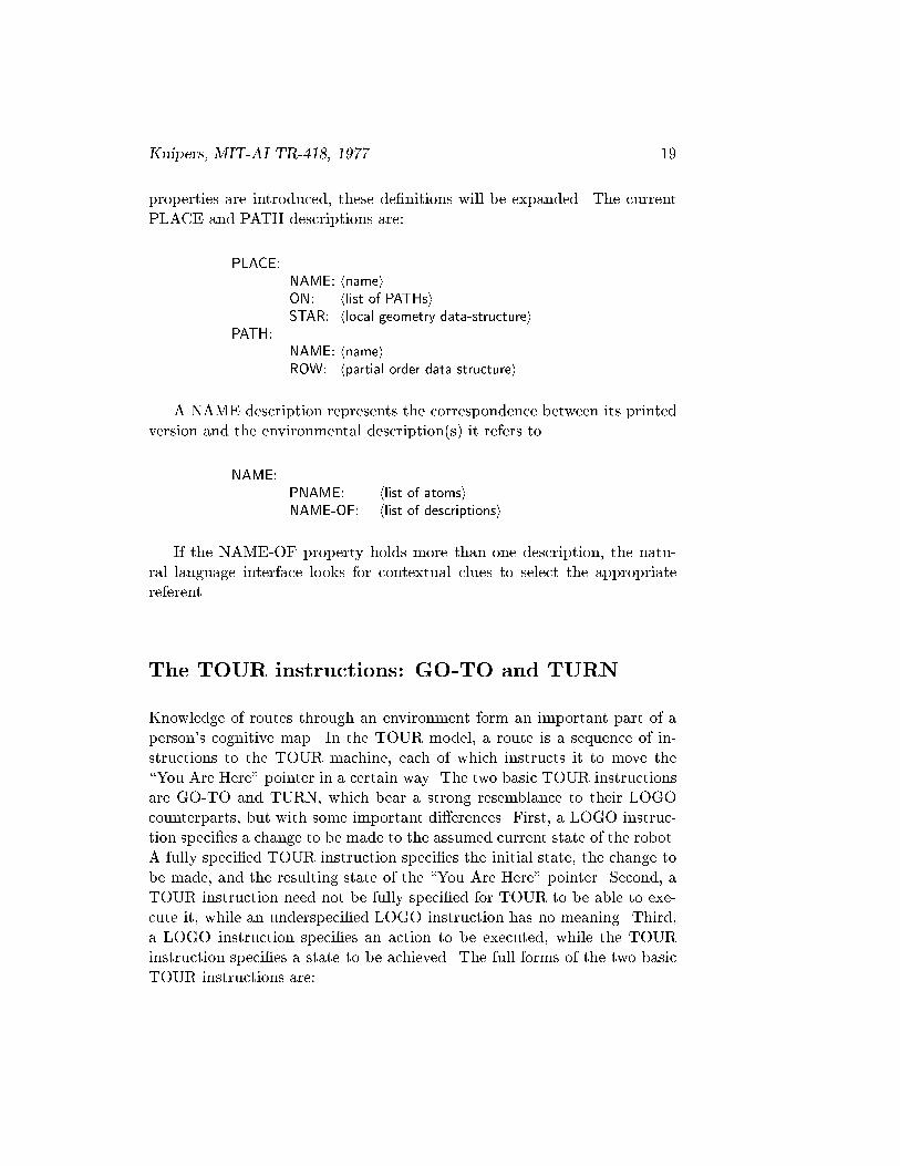
Kuipers, MIT-AI TR-418, 1977. 19
properties are introduced, these de�nitions will be expanded. The currentPLACE and PATH descriptions are:
PLACE:NAME: hnameiON: hlist of PATHsiSTAR: hlocal geometry data-structurei
PATH:NAME: hnameiROW: hpartial order data structurei
A NAME description represents the correspondence between its printedversion and the environmental description(s) it refers to.
NAME:PNAME: hlist of atomsiNAME-OF: hlist of descriptionsi
If the NAME-OF property holds more than one description, the natu-ral language interface looks for contextual clues to select the appropriatereferent.
The TOUR instructions: GO-TO and TURN
Knowledge of routes through an environment form an important part of aperson's cognitive map. In the TOUR model, a route is a sequence of in-structions to the TOUR machine, each of which instructs it to move the\You Are Here" pointer in a certain way. The two basic TOUR instructionsare GO-TO and TURN, which bear a strong resemblance to their LOGOcounterparts, but with some important di�erences. First, a LOGO instruc-tion speci�es a change to be made to the assumed current state of the robot.A fully speci�ed TOUR instruction speci�es the initial state, the change tobe made, and the resulting state of the \You Are Here" pointer. Second, aTOUR instruction need not be fully speci�ed for TOUR to be able to exe-cute it, while an underspeci�ed LOGO instruction has no meaning. Third,a LOGO instruction speci�es an action to be executed, while the TOURinstruction speci�es a state to be achieved. The full forms of the two basicTOUR instructions are:

20
GO-TO: TURN:FR0M: hplacei AT: hplaceiTO: hplacei ST1: hpathiON: hpathi DIR1: hdirectioniDIR: hdirectioni AMT: hnumber of degreesi
ST2: hpathiDIR2: hdirectioni
GO-TO instructs TOUR to move the \You Are Here" pointer from onePLACE to another on the same PATH, and speci�cs the direction of travelwith respect to the PATH order. TURN instructs TOUR to move the \YouAre Here" pointer from one (PATH DIRECTION) pair to another at thesame PLACE, and speci�es the amount of the turn. fAppendix A summa-rizes the TOUR instructions.g A route is simply a sequence of instructionsthat TOUR can treat as a program, and is stored in the map so that itcan be found when needed later: in an association list in the CONNECTproperty of its source, associated with its destination. The formats of thePLACE and ROUTE descriptions are as follows (new parts underlined).
PLACE:NAME: hnameiON: hlist of PATHsiSTAR: hlocal geometry data-structureiCONNECT: hlist of pairs: (PLACE route)i
ROUTE:FROM: hPLACEiTO: hPLACEiSEQUENCE: hlist of TOUR instructionsi
Adding to the cognitive map
The amount of knowledge contained in the map most frequently increasesby the addition of a new PLACE or PATH. Typically, this is done by thenatural language interface as it translates the noun-phrases in a sentenceinto references into the cognitive map, creating new descriptions when noexisting referent can be found. A newly created description has no spatialproperties: perhaps a name. It acquires them from context in the routedescription, and from subsequent references. Thus, the cognitive map ise�ectively unbounded by being implicitly self-extending upon demand.
An individual TOUR instruction can be substantially underspeci�ed.

Kuipers, MIT-AI TR-418, 1977. 21
For example, the English command \Turn right" translates into a TOURinstruction containing only the amount of the turn. The current state canbe obtained from the \You Are Here" pointer, and the destination PATHand DIRECTION can be obtained by examining the local geometry of thecurrent PLACE. Naturally, it is not always possible to �ll in all the gaps inthe current instruction, the \You Are Here" pointer, or the current parts ofthe map. TOUR can move the \You Are Here" pointer along a route whichis quite underspeci�ed even when it is unable to �ll in all the gaps, but therewill be information about the geography implicit in the route description,which cannot then be transferred to the map.
Since the program executed by the TOUR machine can become morefully speci�ed than the one it was given, there can be side-e�ects on theinput route description as well as on the \You Are Here" pointer and themap. This is important because often not all of the information in theroute description can be assimilated into the map on a single pass. Theknowledge about the environment which is only in the route descriptionis not lost, but remains useful for its particular route, and can be foundunder the CONNECT property of its source, indexed under its destination.When the map has reached the proper state, the assimilation process canextract the remaining knowledge for the map, or �ll in missing parts of theroute description from the map. Thus, the role of repetition in the TOURmodel is not simply to strengthen associations, but to reexamine observedinformation in a changed map context.
The TOUR instructions: TAKE and GET-TO
A route program is underspeci�ed when the current position presupposed byan instruction is di�erent from the \You Are Here" pointer. For example,if I am in Kendall Square, desiring a route to Harvard Square, and theproposed route is \Take Mass Ave from Central Square," the assumption isthat I can �nd the route to Central Square. In this case, TOUR formulatesthe di�erence description as a GET-TO instruction that calls the problem-solving component to propose a solution. The proposed solution to such aproblem may itself be an underspeci�ed route, with smaller gaps to be �lledin their turn.
We can now introduce two new TOUR instructions: TAKE and GET-TO. The TAKE instruction refers to a route, and lets it be used as a sub-program for a longer route. This can give a route program a hierarchicalstructure, and it allows frequently-used routes to be shared. The GET-

22
TO instruction formulates a problem to be solved by the problem-solvingcomponent by specifying the state of the \You Are Here" pointer at sourceand destination. In case no solution can be found, the GET-TO instructionis left in the route description, and TOUR continues from its destination.The forms of these instructions are:
TAKE: GET-TO:ROUTE: hroutei FROM: hplaceiFROM: hplace i ST1: hpathiTO: hplace i DIR1: hdirectioni
TO: hplaceiST2: hpathiDIR2: hdirectioni
Before forging onward and adding new properties to the map and toTOUR, let us take stock of where we are. The representations for PLACEsand PATHs, which make up the map, have been described. The instructionsto TOUR which make up route programs have been presented. TOURand the \You Are Here" pointer have been described and their propertiesdiscussed. In addition, the interface to a problem-solver has been discussed.What has been presented thus far is su�cient to support an example ofassimilation of knowledge into the map from a route description.
A cognitive map made from the representation as presented so far wouldconsist primarily of stored routes, each quite well speci�ed, with some topo-logical knowledge about the PATHs and PLACEs involved, but few if anypowerful problem-solving methods. A known route can be found under theCONNECT property of its source, indexed under its destination. Longroutes can be built from shorter ones linking an intermediate goal to the de-sired source and destination, but the search for an appropriate intermediategoal can potentially be very long, so this is often not a practical problem-solving technique. The knowledge described in subsequent chapters willrestrict this search substantially. Such a mental map would serve a personwell in a situation that did not require knowledge of a huge geography, orrapid mastery or discovery of new routes.
An example of TOUR in operation
Here I present an example of the operation of the TOUR machine on a sim-ple route, to show how information is extracted from the route program andassimilated into the PLACEs and PATHs that make up the map. The exam-ple is very simple indeed, so it is important to notice that the assimilation

Kuipers, MIT-AI TR-418, 1977. 23
methods used are independent of the size of the data base. They use onlyinformation directly accessible from the current instruction and the \YouAre Here" pointer, and thus would work in exactly the same way within amuch larger map.
For this example of assimilation, the TOUR model will begin with a verylimited knowledge of the part of Cambridge, Massachusetts shown below.It begins the example located at the intersection of Broadway and ProspectStreet.
X
X
Central Avenue
Prospect Street
Harvard Sq.X
CirclePutnam
Mass Ave.
Broadway
Kendall Sq.
MITX X
X
The initial state of the cognitive map for this example is listed below.Notice that the relation between Mass Ave and the intersection of Broadwayand Prospect Street is not known. Neither does the cognitive map containany description of Putnam Circle or Kendall Square.
PATH1: PLACE1:NAME: Mass Ave NAME: Harvard SquareROW: (PLACE1 PLACE2 PLACE3) ON: [PATH1: Mass Ave]
STAR: nil
PATH2: PLACE2:NAME: Broadway NAME: Central SquareROW: (PLACE4) ON: [PATH1: Mass Ave]
STAR:(0. PATH1 �1)(180. PATH1 +1)

24
PATH3: PLACE3:NAME: Prospect Street NAME: MITROW: (PLACE4) ON: [PATH1: Mass Ave]
STAR: nil
PLACE4:NAME: nilON:[PATH2: Broadway]
[PATH3: Prospect Street]STAR: nil
Recall that a PATH description contains a partially ordered set of PLACEsunder its ROW property, as a list of totally ordered fragments. The accessfunctions in this case attempt to merge the fragments into a total orderwhenever new information is provided. The ON property of a PLACE de-scription is a list of the PATHs which that place is on. The STAR propertyrepresents the local geometry of the intersection. The value of the STARproperty is a list of triples, each of which speci�es a heading (in degrees)with respect to the local set of coordinates, followed by the PATH and DI-RECTION having that heading. The DIRECTION on a PATH is speci�edas +1 or �1 and means \with" or \against" the order contained in thatPATH's ROW property. Thus it is a conventional attribute of a PATH, andneed not correspond to any global property.
The street directions
This example will follow the knowledge states involved in the assimilationof the route description given below. A new piece of information in a de-scription will be underlined. A recapitulation with minor variations willillustrate further properties.
The example will begin with the \You Are Here" pointer at the intersec-tion of Broadway and Prospect Street, on Prospect Street, with an unknownDIRECTION.
YOU ARE HERE:PLACE: [PLACE4: \Broadway & Prospect Street"]PATH: [PATH3: Prospect Street]DIRECTION: nil
\Take Prospect Street to Central Square." (1)\Turn right." (2)\Take Mass Ave to Putnam Circle." (3)

Kuipers, MIT-AI TR-418, 1977. 25
The street directions are given in a subset of English. They are translatedin a straight-forward way to instructions for the TOUR machine. fNoteLINGOLg The two TOUR instructions that we shall be concerned withhere are GO-TO and TURN. Thus, sentences (1) - (3) are translated into theinternal instructions below. The amount of a turn is given as the clockwisechange in heading (modulo 360). fNote Quantitiesg
GO-TO: (4)FROM: nilTO: [PLACE2: Central Square]
ON: [PATH3: Prospect Street]
DIR: nil
TURN: (5)AT: nilST1: nilDIR1: nilAMT: 90.ST2: nilDIR2: nil
GO-TO: (6)FROM: nilTO: [PLACE5: Putnam Circle]
ON: [PATH1: Mass Ave]
DIR: nil
while the input interface automatically creates a new place-description forinstruction (6):
PLACE5:NAME: Putnam CircleON: nilSTAR: nil
Inside the TOUR machine
All three kinds of description that we have seen can be partially speci�ed:the map descriptions of PATH and PLACE, the \You Are Here" pointer, andthe instructions to the TOUR machine. The TOUR machine communicatesinformation between several di�erent representations of spatial knowledge by�lling in underspeci�ed instructions and descriptions when possible. Whenexecuting an instruction, TOUR matches the current position in the \You

26
Are Here" pointer against the current state presupposed by the instruction.Then it checks the instruction for consistency with the map, and changesthe \You Are Here" pointer to represent the new position. Informationin the map can �ll unspeci�ed parts of the instruction. A fully speci�edinstruction can contribute new information to the \You Are Here" pointeror to the map, adding to the order information in a PATH or the localgeometry of a PLACE.
Internally, the TOURmachine is organized as a production system [Newell& Simon 1972], consisting of modular inference rules that are activated oncombinations of features of the current environment. This computational en-vironment consists of the current instruction, the \You Are Here" pointer,and the parts of the map they point to. The productions transfer piecesof information from one description to another, resulting in a three-wayinteraction among the parts of the environment.
To describe these productions, and the patterns they look for, two kindsof informal syntax are called for. First, to refer to a property of a description,I will write \hdescriptioni/hpropertyi", referring to the value if I am readingit, or the place the value is stored, if I am writing it. In either case, accessis actually mediated by access functions. Thus, in the preceding database,I may say either, \Put `Putnam Circle' into PLACE5/NAME," or \Thevalue (or contents) of PLACE5/NAME is `Putnam Circle'." Furthermore,\/" is left-associative, so that \TURN/AT/ON" refers to the value of theON property of the PLACE which is the value of the AT property of thecurrent TURN instruction. Thus if the current instruction is a TURN takingplace at the intersection of Broadway and Trowbridge Street, TURN/AT isPLACE4 and PLACE4/ON holds PATH2 and PATH3. (Rest assured thatthe syntax is harder to explain than to read: it means pretty much what youthink it does.) The second kind of informal syntax allows me to abbreviatereferences to parts of the \You Are Here" pointer by referring to the valuesof C-PLACE, C-PATH, an C-DIRECTION (for \current place", etc.).
Each time an instruction is to be executed, the productions associatedwith the current type of instruction are activated in sequence. Unless oneof the productions explicitly restarts the execution cycle each production isgiven a chance to act. A production may detect a con ict between the \YouAre Here" pointer and the initial state assumed by the current instruction,insert a missing instruction into the route description, and restart the ex-ecution cycle. The ordering of the productions is signi�cant. The TOURmachine will function under a variety of di�erent orderings of its produc-tions, but with quite di�erent behavior. This phenomenon may contributeto an explanation of variation in spatial cognitive style in humans. fNote
Kuipers, MIT-AI TR-418, 1977. 27
Variationg
The productions that implement this behavior are given below, in a\formal" version of English. GO-l, GO-2, and GO-3 compare the descriptionof the current state in the \You Are Here" pointer with the current stateassumed by the GO-TO instruction, and �ll in missing elements. GO-4and GO-5 make the topological connection between PATHs and PLACEsimplied by a GO-TO instruction. GO-5 also adds to the order knowledgerepresented in the PATH description. GO-6 transfers order information theother way: from the PATH description to the GO-TO instruction. GO-7performs a very limited \look-behind" to update the previous instructionwith DIRECTION information deduced by this instruction. And �nally,GO-8 actually accomplishes the e�ect of the instruction on the \You AreHere" pointer.
GO-1: Compare GO-TO/FROM and C-PLACE. If both are empty, there is anerror. If they agree, do nothing. If only one is supplied, set the other fromits value. If they disagree, insert a GET-TO instruction as the new currentinstruction preceding this GO-TO, and restart.
GO-2: Compare GO-TO/PATH and C-PATH. If both are empty, there is an error.If they agree, do nothing. If only one is supplied, set the other from its value. Ifthey disagree, insert a TURN instruction, and restart.
GO-3: Compare GO-TO/DIR and C-DIRECTION. If they agree, do nothing. Ifonly one is supplied, use its value to set the other. If they disagree, insert a\Turn around" instruction.
GO-4: Send GO-TO/PATH to GO-TO/FROM/ON and GO-TO/TO/ON. (APLACE description checks internally for redundant information.)
GO-5: If GO-TO/DIR is supplied, send GO-TO/FROM and GO-TO/TO as anordered pair to GO-TO/PATH/ROW. If not, send them as two singletons. (ThePATH description will incorporate this information into its partial order.)
GO-6: Ask GO-TO/PATH if it knows an order on GO-TO/FROM and GO-TO/-TO. If not, do nothing. If so, and GO-TO/DIR is empty, set it. If so, and itdisagrees with GO-TO/DIR, complain of an error. Otherwise, do nothing.
GO-7: If GO-TO/DIR is supplied, and the preceding instruction was a TURNwith empty TURN/DIR2, then set that TURN/DIR2 to the value of GO-TO/-DIR. fNote Look-behindg
GO-8: Set C-PLACE to GO-TO/TO, and C-DIRECTION to GO-TO/DIR.
A similar set of productions perform the action of the TOUR machine ona TURN instruction. TURN-l, TURN-2, and TURN-3 make the comparisonbetween the \You Are Here" pointer and the current TURN instruction.

28
TURN-4 makes the topological connection between the PATHs and PLACEsinvolved. TURN-5 transfers knowledge about the local geometry of theintersection from a fully speci�ed TURN instruction to TURN/PLACE/-STAR. TURN-6 and TURN-7 use the local geometry of the intersection toprovide missing information in the TURN instruction. TURN-8 representsthe default heuristic that a turn at a two-street intersection usually resultsin your being on the other street. TURN-9 provides a blank descriptionin case all else fails to identify the street the turn puts you on. TURN-10�nally accomplishes the e�ect of the TURN instruction on the \You AreHere" pointer.
TURN-1: Compare TURN/PLACE with C-PLACE. If both are empty, there isan error. If they agree, do nothing. If only one is supplied, set the other fromits value. If they disagree, insert a GET-TO instruction as the new currentinstruction preceding this TURN, and restart.
TURN-2: Compare TURN/ST1 with C-PATH. If both are empty, there is anerror. If they agree, do nothing. If only one is supplied, set the other from itsvalue. If they disagree, insert a second TURN instruction before this, commenton the oddness and restart.
TURN-3: Compare TURN/DIR1 with C-DIRECTION. If they agree, do nothing.If only one is supplied, set the other from its value. If they disagree, there is anerror.
TURN-4: Send TURN/ST1 and TURN/ST2 to TURN/PLACE/ON. Also, senda singleton order containing TURN/PLACE to TURN/ST1/ROW and TURN/-ST2/ROW.
TURN-5: If TURN/ST1, TURN/DIR1, TURN/ST2, TURN/DIR2, and TURN/-AMT are all supplied, then send them to TURN/PLACE/STAR, to add to thedescription of local geometry of the PLACE. (The PLACE description incorpo-rates this into the appropriate data structure.)
TURN-6: If TURN/ST1, TURN/DIR1, and TURN/AMT are all supplied, butTURN/ST2 and TURN/DIR2 are not both supplied, then ask TURN/PLACE/-STAR to compute the description of the outgoing PATH from the incomingPATH and the amount of the TURN. If that is successful, use the result to setTURN/ST2 and TURN/DIR2.
TURN-7: If TURN/ST1, TURN/DIR1, TURN/ST2, and TURN/DIR2 are allsupplied but TURN/AMT is not, then ask TURN/PLACE/STAR to compute it.If that is successful, set TURN/AMT to the result.
TURN-8: If TURN/ST2 remains un�lled, and TURN/PLACE/ON contains twoPATH drecriptions, one of which is TURN/ST1, then set TURN/ST2 to theother.

Kuipers, MIT-AI TR-418, 1977. 29
TURN-9: If TURN/ST2 still remains un�lled, then create a new PATH descrip-tion to �ll TURN/ST2. Send it to TURN/PLACE/ON, and send a singletoncontaining TURN/PLACE to the ROW property of the new PATH. (This PATHdescription may describe the same real street as a previously created PATH de-scription, requiring some debugging later.)
TURN-10: Set C-PATH to TURN/ST2, and set C-DIRECTION to TURN/DIR2.
The productions which implement TAKE and GET-TO for the TOURmachine are not included here because they are not needed for the example.They can be found in Appendix B.
The �rst sentence
X5
Broadway
Prospect
Sentence (1) is translated into instruction (4):
\Take Prospect Street to Central Square." (1)GO-TO: (4)
FROM: nilTO: [PLACE2: Central Square]
0N: [PATH3: Prospect Street]
DIR: nil
GO-1 provides information about the current position, producing:
GO-TO: (4.1)FROM: [PLACE4: \Broadway & Prospect Street"
TO: [PLACE2: Central Square]ON: [PATH3: Prospect Street]DIR: nil
When executing a GO-TO instruction, GO-5 would like to send orderinformation about PLACE2 and PLACE4 to PATH3. The instruction, how-ever, does not specify their relative order, so the two fragments (PLACE2)and (PLACE4) are sent to PATH3. PATH3, via its access functions, cannow de�ne an order on the places it knows about. PLACE2 and PLACE4
30
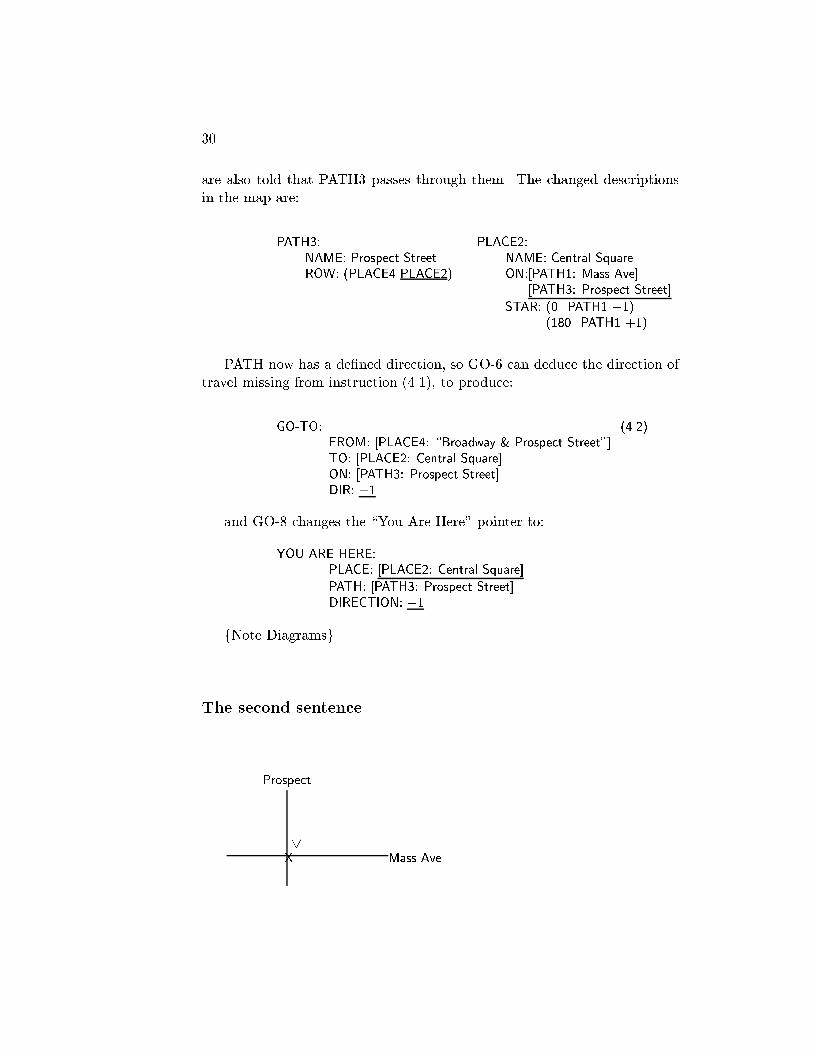
are also told that PATH3 passes through them. The changed descriptionsin the map are:
PATH3: PLACE2:NAME: Prospect Street NAME: Central SquareROW: (PLACE4 PLACE2) ON:[PATH1: Mass Ave]
[PATH3: Prospect Street]
STAR: (0. PATH1 �1)(180. PATH1 +1)
PATH now has a de�ned direction, so GO-6 can deduce the direction oftravel missing from instruction (4.1), to produce:
GO-TO: (4.2)FROM: [PLACE4: \Broadway & Prospect Street"]TO: [PLACE2: Central Square]ON: [PATH3: Prospect Street]DIR: +1
and GO-8 changes the \You Are Here" pointer to:
YOU ARE HERE:PLACE: [PLACE2: Central Square]
PATH: [PATH3: Prospect Street]DIRECTION: +1
fNote Diagramsg
The second sentence
Prospect
5
X Mass Ave.
Kuipers, MIT-AI TR-418, 1977. 31
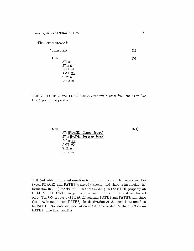
The next sentence is:
\Turn right." (2)
TURN: (5)AT: nilST1: nilDIR1: nilAMT: 90.ST2: nilDIR2: nil
TURN-l, TURN-2, and TURN-3 supply the initial state from the \You AreHere" pointer to produce:
TURN: (5.1)AT: [PLACE2: Central Square]
ST1: [PATH3: Prospect Street]
DIR1: +1AMT: 90.ST2: nilDIR2: nil
TURN-4 adds no new information to the map because the connection be-tween PLACE2 and PATH3 is already known, and there is insu�cient in-formation in (5.1) for TURN-5 to add anything to the STAR property onPLACE2. TURN-8 then jumps to a conclusion about the street turnedonto. The ON property of PLACE2 contains PATH1 and PATH3, and sincethe turn is made from PATH3, the destination of the turn is assumed tobe PATH1. Not enough information is available to deduce the direction onPATH1. The �nal result is:

32
TURN: (5.2)AT: [PLACE2: Central Square]ST1: [PATH3: Prospect Street]DIR1: +1AMT: 90.ST2: [PATH1: Mass Ave]
DIR2: nil
and
YOU ARE HEREPLACE: [PLACE2: Central Square]PATH: [PATH1: Mass Ave]
DIRECTION: nil
The third sentence
Prospect
X Mass Ave.
\Take Mass Ave to Putnam Circle." (3)
GO-TO: (6)FROM: nilTO: [PLACE5: Putnam Circle]
ON: [PATH1: Mass Ave]
DIR: nil
Again, GO-1 provides the initial position, and GO-2 con�rms that we areon the right street.
This produces:
GO-TO: (6.1)FROM: [PLACE2: Central Square]
TO: [PLACE5: Putnam Circle]
ON: [PATH1: Mass Ave]
DIR: nil

Kuipers, MIT-AI TR-418, 1977. 33
Exactly as in the �rst sentence, GO-5 can send only minimal order infor-mation to PATH1. This corresponds to knowing that Putnam Circle is onMass Ave, but not knowing where. The result on the map is:
PATH1: PLACE5:NAME: Mass Ave NAME: Putnam CircleROW: (PLACE1 PLACE2 PLACE3) ON: [PATH1: Mass Ave]
(PLACE5) STAR: nil
GO-6 cannot deduce the direction of travel for this instruction, and GO-8�nally moves the \You Are Here" pointer.
YOU ARE HERE:PLACE: [PLACE5: Putnam Circle]
PATH: [PATH1: Mass Ave]DIRECTION: nil
X Mass Ave.X
Prospect
Circle Putnam
The route-description, extended by the inferences that have been made byTOUR, is saved for later use. Indexed under its source and destination,it can be retrieved when needed again. The �nal version of the route-description is:

34
GO-TO: (4.2)FROM: [PLACE4: \Broadway & Prospect Street"]TO: [PLACE2: Central Square]ON: [PATH3: Prospect Street]DIR: +1
TURN: (5.2)AT: [PLACE2: Central Square]ST1: [PATH3: Prospect Street]DIR1: +1AMT: 90.ST2: [PATH1: Mass Ave]DIR2: nil
GO-TO: (6.1)FROM: [PLACE2: Central Square]TO: [PLACE5: Putnam Circle]ON: [PATH1: Mass Ave]DIR: nil
Because each production makes only a limited, local deduction, one passover the route description may not extract all of the available information.For example, this route-description includes the fact that, wherever PutnamCircle is located on Mass Ave, a right turn at Central Square from ProspectStreet points you in that direction. This fact is not captured by the partialorder in PATH1/ROW. A later assimilation of this route may be able toextract that information for the map, once the local geometry of PLACE2is more fully speci�ed. This possibility is examined in the second alternativebelow.
Further examples
It will illuminate the execution of a route by TOUR to discuss brie y acouple of alternate versions of the above example, and show how the resultis di�erent. First, consider the same route-description, but with sentence(3) replaced by:
\Take Mass Ave to Harvard Square." (3.1)
Since the destination was previously known, GO-6 can deduce the direc-tion of travel for (6.2), below, from PATH1/ROW. Then GO-7 can reachback to set the preceding TURN/DIR2, to produce (5.3). This results inthe following route description.
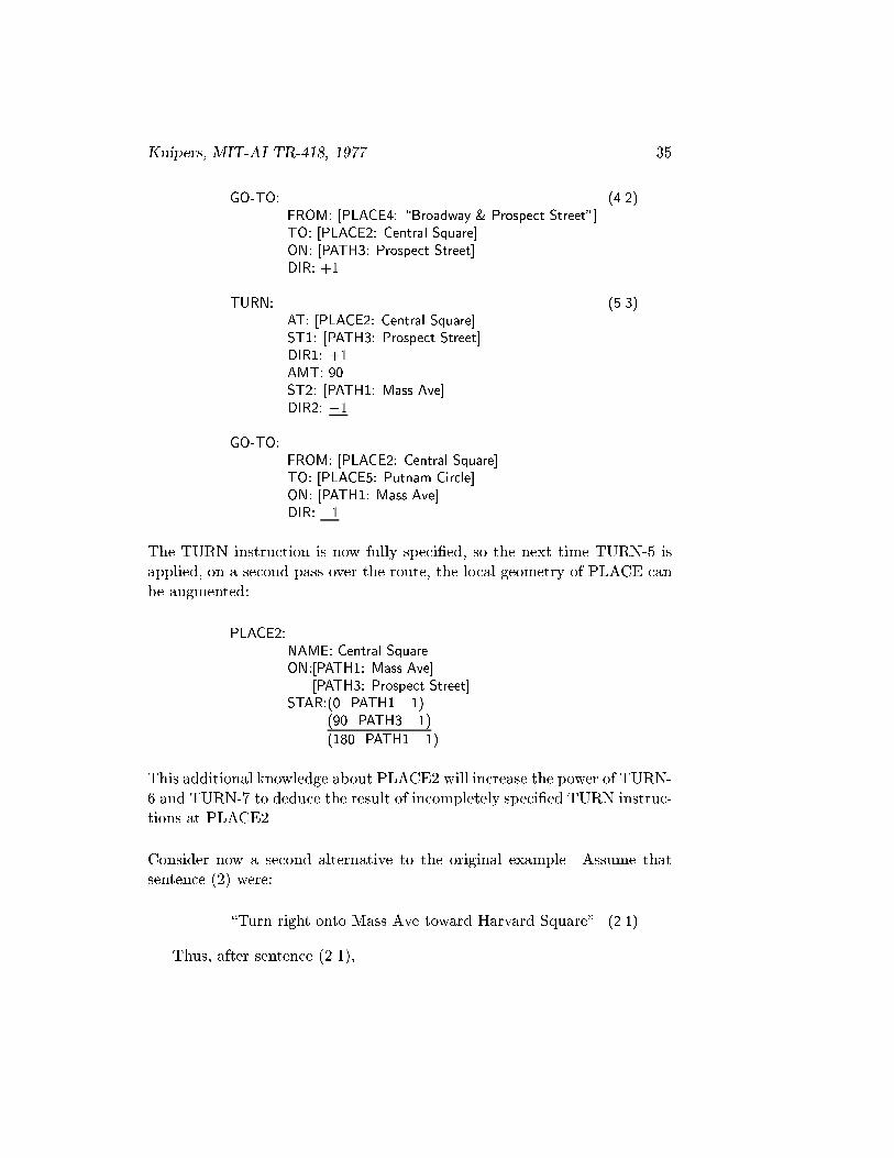
Kuipers, MIT-AI TR-418, 1977. 35
GO-TO: (4.2)FROM: [PLACE4: \Broadway & Prospect Street"]TO: [PLACE2: Central Square]ON: [PATH3: Prospect Street]DIR: +1
TURN: (5.3)AT: [PLACE2: Central Square]ST1: [PATH3: Prospect Street]DIR1: +1AMT: 90.ST2: [PATH1: Mass Ave]DIR2: �1
GO-TO:FROM: [PLACE2: Central Square]TO: [PLACE5: Putnam Circle]ON: [PATH1: Mass Ave]DIR: �1
The TURN instruction is now fully speci�ed, so the next time TURN-5 isapplied, on a second pass over the route, the local geometry of PLACE canbe augmented:
PLACE2:NAME: Central SquareON:[PATH1: Mass Ave]
[PATH3: Prospect Street]STAR:(0. PATH1 �1)
(90. PATH3 �1)
(180. PATH1 +1)
This additional knowledge about PLACE2 will increase the power of TURN-6 and TURN-7 to deduce the result of incompletely speci�ed TURN instruc-tions at PLACE2.
Consider now a second alternative to the original example. Assume thatsentence (2) were:
\Turn right onto Mass Ave toward Harvard Square" (2.1)
Thus, after sentence (2.1),
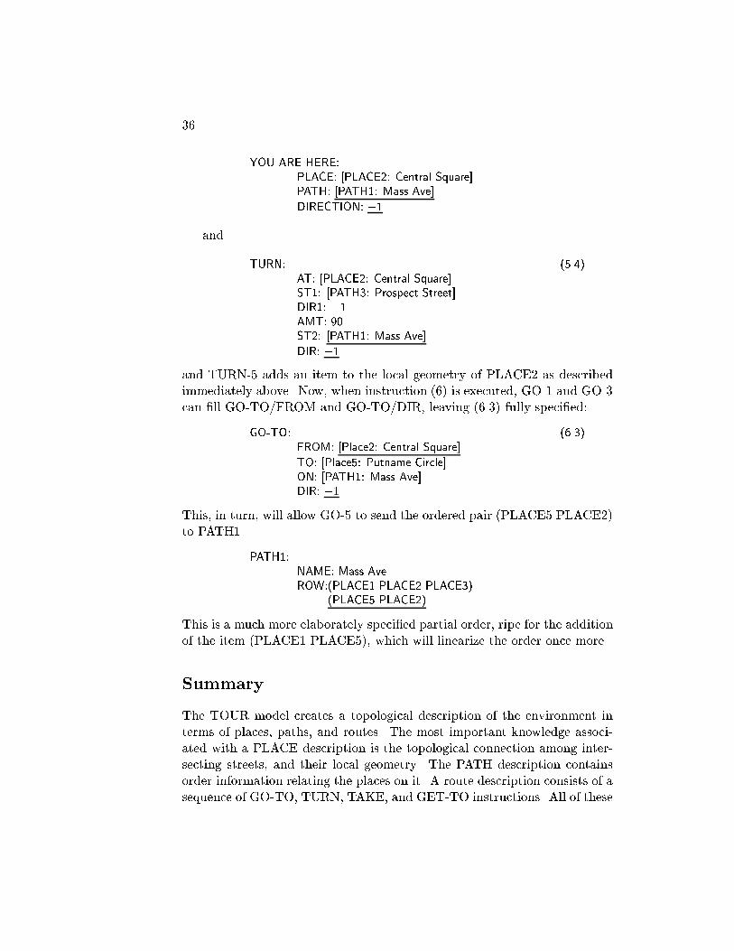
36
YOU ARE HERE:PLACE: [PLACE2: Central Square]PATH: [PATH1: Mass Ave]
DIRECTION: �1
and
TURN: (5.4)AT: [PLACE2: Central Square]ST1: [PATH3: Prospect Street]DIR1: +1AMT: 90.ST2: [PATH1: Mass Ave]
DIR: �1
and TURN-5 adds an item to the local geometry of PLACE2 as describedimmediately above. Now, when instruction (6) is executed, GO-1 and GO-3can �ll GO-TO/FROM and GO-TO/DIR, leaving (6.3) fully speci�ed:
GO-TO: (6.3)FROM: [Place2: Central Square]
TO: [Place5: Putname Circle]ON: [PATH1: Mass Ave]DIR: �1
This, in turn, will allow GO-5 to send the ordered pair (PLACE5 PLACE2)to PATH1.
PATH1:NAME: Mass AveROW:(PLACE1 PLACE2 PLACE3)
(PLACE5 PLACE2)
This is a much more elaborately speci�ed partial order, ripe for the additionof the item (PLACE1 PLACE5), which will linearize the order once more.
Summary
The TOUR model creates a topological description of the environment interms of places, paths, and routes. The most important knowledge associ-ated with a PLACE description is the topological connection among inter-secting streets, and their local geometry. The PATH description containsorder information relating the places on it. A route description consists of asequence of GO-TO, TURN, TAKE, and GET-TO instructions. All of these

Kuipers, MIT-AI TR-418, 1977. 37
descriptions can be underspeci�ed in important ways. A route descriptionis stored in the cognitive map, associated with its source and destination.
The example shows how the TOUR machine takes an underspeci�edroute-description, and executes it to drive the \You Are Here" pointerthrough the map. The productions which constitute this part of the TOURmachine, and the way they act to assimilate information, have been shown.In addition, the example shows how small variations in the correspondencebetween the route-description and the cognitive map make a large di�erencein the amount of knowledge that can be as simulated at that time. However,nothing from the route-description is discarded: it simply waits in the rela-tively inaccessible route representation until the map satis�es the conditionsof the inference rules that will assimilate it.
Two additional important facts are worth emphasizing. The �rst is thatthe assimilation process uses only locally available information, with nosearch of the map. Thus, assimilation proceeds independently of the sizeof the database containing the map. Second, assuming that the route de-scription is correct, the description in the cognitive map may be partiallyspeci�ed, but it will not be wrong. The well-known inaccuracies in people'smental maps lie in the more global kinds of description which are presentedin the following chapters. In those cases, global conclusions are drawn fromlocal observations, so they are quite vulnerable to error.

38
Chapter 3
Orientation
Orient. v. tr. 1. To locate or place in a particular relationto the points of the compass: Orient the swimming pool northand south. 2. To cause to face the east; locate or place so as toface the east. 3. To align or position with respect to a referencesystem. 4. To discover the bearings of. Often used re exively:He oriented himself by �nding a familiar landmark. 5. To causeto become familiar with or adjusted to facts, principles, or asituation.
[American Heritage Dictionary, 1973]
Each of the next three chapters will show how a di�erent kind of spatialknowledge can be described in terms of the TOUR model, with emphasis onthe states of partial knowledge each representation can maintain. Each ofthese kinds of knowledge is largely based on the topological representationof Chapter 2, and they are largely independent of each other. This chapterdiscusses orientation and the concept of a \sense of direction." Chapter 4deals with partial knowledge of position. Chapter 5 shows how structures ofcontaining regions can be used to simplify route-�nding and the representa-tion of position.
Examples of orientation
A number of di�erent kinds of knowledge fall under the term \orientation."As the de�nition above shows, orientation means knowing one's positionwith respect to some reference system. The reference system which is mostoften referred to explicitly is the set of cardinal directions: East, North,West, and South. These cardinal directions, however, are but a special case
39

40
among more general reference systems with respect to which a person canorient himself. I hope to convince the reader by simple anecdotal exam-ples that a person's mental map typically contains a number of more-or-lessrelated reference systems. Some of these anecdotes are con�rmed by theliterature in psychology and urban planning. The anecdotes provide a sub-jective de�nition of the phenomena which the TOUR model will describe.The bulk of this chapter is devoted to explaining the aspects of the TOURmodel which describe the following characteristics of orientation and refer-ence systems.
1. Position is often given as a relation between two places and a referencesystem, not an absolute property of a single place. For example, as I sit inmy o�ce at MIT, I can say, \Harvard Square is two miles west of here,"or \As I face Central Square, Harvard Square is two miles ahead and tomy right." Either statement de�nes the position of Harvard Square withrespect to my current position and some reference system. However, sayingonly \Harvard Square is two miles away," leaves the position underspeci�ed.
2. There are many reference systems with respect to which positions maybe de�ned. The above example uses the cardinal directions and an egocen-tric reference system tied to my current position and heading. To use thelatter for communication, my audience must know where I am. Often I mayde�ne my position with respect to a reference system which is tied to theenvironment, but which is di�erent from the system of cardinal directions.For example, when a set of streets is laid out as a grid, as in Manhattan, Ican de�ne positions with respect to the reference system of the grid, evenwhen I am ignorant of the cardinal directions.
3. The relation between di�erent reference systems may be unknown. It is acommon phenomenon to be quite well oriented within each of two districts,but not know the relation between them. For example, Back Bay in Bostonis a rectangular grid, as is most of Palo Alto, California. Neither, however,is aligned with the cardinal directions, and even a person familiar with bothmust pause to compute the relation between them. In this particular case,most people compare them by relating each to the cardinal directions andcomparing the resulting headings.
4. Many people orient themselves with respect to conspicuous landmarks.In Boston, the Prudential Building and the John Hancock Building provideconvenient reference points, visible from most of the city. This gives theobserver knowledge of his own heading, a rough notion of the radial directionfrom the landmarks to his current position, and a still rougher notion of his

Kuipers, MIT-AI TR-418, 1977. 41
distance. In di�erent environments, other geographical features can playsome or all of these roles. A mountain range or the seashore can oftenserve as such a landmark, even leading the unwary observer astray whenit changes its meaning unexpectedly. For example, the Paci�c Ocean is alandmark de�ning \west" throughout most of California, causing confusionin Santa Barbara where its true direction is south. The position of the sunacts as a time-varying but usually accessible landmark to which the cardinaldirections are tied.
5. A reference system need not be tied to a large geographical structurelike a mountain or a set of grid-structured streets. It may be created torepresent the locations of a small set of nearby but mutually invisible places,whose positions are computed by \dead reckoning" along short routes. Forexample, if I reach the opposite corner of a rectangular block by followingone side, making a right turn, then following a second side, I can locate mystarting point as behind me and to my right, with a reasonably accuratenotion of the direction and distance. Over longer or more complex routes,the accuracy of this \common-sense trigonometry" degrades considerably.
6. A \sense of direction" seems to be primarily the ability to describe whereyou are with respect to other places. Thus, the \You Are Here" pointermust contain information about the current heading. It also means that theheading and the associated reference system provide access to informationabout the locations of a signi�cant set of places. An additional conversa-tional meaning of the phrase \sense of direction" is that a person has agood ability to acquire and maintain this kind of information in unfamiliarterritory.
Describing orientation in the TOUR model
The TOUR model must be expanded somewhat to accommodate these phe-nomena. The most important addition to the TOUR model is that the\You Are Here" pointer is augmented to include the current HEADING ofthe traveller with respect to some reference system. A reference system isrepresented in the cognitive map by a description called an ORIENTATION-FRAME. Since the current HEADING is only meaningful with respect to thecurrent ORIENTATION-FRAME, it too is included in the expanded \YouAre Here"pointer. An example of the expanded \You Are Here" pointermight be:

42
YOU ARE HERE:PLACE: [PLACE4: \Broadway & Prospect Street"]PATH: [PATH2: Broadway]DIRECTION: +1ORIENTATION-FRAME: ORIENT2HEADING: 180.
The HEADING can take on integer values from 0 to 359 degrees. fNoteQuantitiesg HEADING is an angular, two-dimensional orientation with re-spect to the current ORIENTATION-FRAME, and contrasts with DIREC-TION, which is a binary speci�cation of orientation with respect to thecurrent PATH (a one-dimensional space). For brevity, the current HEAD-ING and ORIENTATION-FRAME are referred to as C-HEADING and C-ORIENT, respectively.
In Chapter 2, the headings in PLACE/STAR were implicitly de�nedwith respect to a reference system local to that PLACE. Here that referencesystem is made explicit and related to more global kinds of orientation.
An ORIENTATION-FRAME is a description of a reference system withrespect to which HEADINGs can be de�ne. It has the following properties:
ORIENTATION-FRAME:TYPE: hone of fLOCAL, REGIONAL, CARDINALg iDOMAIN: hPLACE or REGIONiOTHERS: hlist of pairs: (ORIENTATION-FRAME ANGLE)i
If ORIENT/TYPE is LOCAL, then the reference system being describedis limited to a single PLACE, held in ORIENT/DOMAIN, where it providesthe basis for the local geometry. If ORIENT/TYPE is REGIONAL, thenthe reference system has a more extended domain, which is described bythe REGION held in ORIENT/DOMAIN. (REGIONs are described below.)ORIENT/OTHERS contains pairs describing the relationship between thisand other reference systems. ANGLE is the number to be added (modulo360) to a HEADING with respect to this ORIENTATION-FRAME in orderto describe the same real-world heading, but with respect to the associatedORIENTATION-FRAME.
A REGION is a description of a geographical area: a collection ofPLACEs and PATHs. In this context, it describes the domain of appli-cation of an ORIENTATION-FRAME. We will encounter REGIONs againin other contexts, where we will expand the following description:

Kuipers, MIT-AI TR-418, 1977. 43
REGION:TYPE: hone of fORIENTg i ; to be expanded!ORIENT: hORIENTATION-FRAMEiPLACES: hlist of PLACEsiPATHS: hlist of PATHsi
If REGION/TYPE is ORIENT, then this REGION describes the do-main of an ORIENTATION-FRAME, which is held in REGION/ORIENT.PLACEs and PATHs which are in the REGION are listed in REGION/-PLACES and REGION/PATHS, respectively. When a place or path is in aregion, then the REGION description is also put into PLACE/IN or PATH/-IN. We will encounter other values of REGION/TYPE in later chapters.
Once the current HEADING is known by the \You Are Here" pointer, itis quite straight-forward to maintain it while following a route. If the amountof a TURN is known, the HEADING is updated; a GO-TO instruction leavesthe HEADING constant if the street is straight. If these conditions are notmet, then C-HEADING is cleared, and the \You Are Here" pointer is lesswell oriented. We must therefore add a new element to a PATH descriptionto describe its shape. We will de�ne PATH/SHAPE as having a defaultvalue of STRAIGHT. Any other value will prevent the HEADING frombeing maintained along that street. fNote Shape Theoryg
TURN-11: If C-HEADING and TURN/AMT are set, then update C-HEADINGby TURN/AMT; otherwise clear C-HEADING and C-ORIENT.
GO-9: If C-HEADING is set, then check C-PATH/SHAPE. If its value is STRAIGHT,then do nothing; else clear C-HEADING and C-ORIENT.
Here we approach an area of great individual variation in spatial cog-nitive styles. Some people can maintain their orientation along a curvingroad, while others are disoriented by any turn. It appears likely that manyvariants can be represented within the TOUR model by replacing GO-9 andTURN-11 with the appropriate substitutes, or by leaving them out alto-gether.
Interactions between HEADING and DIRECTION
When both HEADING and DIRECTION are supplied, the \You Are Here"pointer is redundant. This means that the relation between them can bestored as part of the description of the associated PATHs and PLACEs.Conversely, information from PATHs and PLACEs can be used to infer thecurrent HEADING or DIRECTION.

44
This relationship is represented by adding a new element to the PATHdescription to represent its HEADING, facing its +1 direction. Because aPATH may have several di�erent HEADINGs, PATH/HEADING may con-tain several (ORIENTATION-FRAME HEADING) pairs. The current fullform of a PATH description is as follows, with newly added parts underlined.
PATH:NAME: hnameiROW: hpartial order data-structureiHEADING: hlist of pairs: (ORIENTATION-FRAME HEADING) i
SHAPE: hdescriptive tag, e.g. STRAIGHTi
IN: hlist of REGIONsi
The TOUR model is also augmented by inference rules to make deduc-tions about these relationships. One set of inferences uses information fromthe current PLACE or PATH to �ll in a missing ORIENTATION-FRAME,HEADING, or DIRECTION element of the \You Are Here" pointer.
TURN-12: If C-ORIENT is empty, set it to C-PLACE/ORIENT.
TURN-13: If C-ORIENT and C-DIR are both supplied, but C-HEADING is empty,and if C-ORIENT matches C-PLACE/ORIENT, then try to set C-HEADING tothe heading associated with (C-PLACE C-DIR) in C-PLACE/STAR.
GO-10: If C-ORIENT and C-DIR are both supplied, but C-HEADING is not,then see if C-ORIENT is associated with a heading in C-PATH/HEADING. If so,take C-DIR into account, and set C-HEADING.
GO-11: If C-ORIENT and C-HEADING are both supplied, but C-DIR is not, thencheck C-PATH/HEADING to see if C-ORIENT is associated with a heading. Ifso, and it is close to C-HEADING or its opposite, set C-DIR accordingly. If theheadings match very poorly, ag a potential error, and go on.
The other set of inferences add information from the \You Are Here"pointer to the current PLACE or PATH.
GO-12: If C-HEADING and C-DIR are both supplied, then let THETA be theheading of C-PATH in the +1 direction. Put (C-ORIENT THETA) into C-PATH/HEADING.
TURN-14: If C-HEADING and C-DIR are both supplied, and if C-ORIENT isthe same as C-PLACE/ORIENT, then put (C-HEADING C-PATH C-DIR) intoC-PLACE/STAR.

Kuipers, MIT-AI TR-418, 1977. 45
An example with HEADING
Let us consider an example in which the HEADING is maintained, and in-formation about it is transferred between map descriptions and the \YouAre Here" pointer. This example will follow a route over the territory cov-ered in the previous chapter. In this case, the route-description will becomplete at the beginning, so all of the action will take place in the \YouAre Here" pointer and in the PLACE and PATH descriptions. The routebeing followed is shown in the map below:
X
X
Central Avenue
Prospect Street
Harvard Sq.X
CirclePutnam
Mass Ave.
Broadway
Kendall Sq.
MITX X
X
Start on Broadway, at the intersection of Broadway and Prospect Street,facing Kendall Square.
Turn right onto Prospect Street.Take Prospect Street to Central Square.Turn right onto Mass Ave.Take Mass Ave to Putnam Circle.
We begin at the intersection of Broadway and Prospect Street, facingKendall Square (PLACE6).
YOU ARE HERE:PLACE: [PLACE4: \Broadway & Prospect Street"]PATH: [PATH2: Broadway]DIRECTION: +1
The relevant parts of the map description of this geography are givenbelow.

46
PATH1:NAME: Mass AveROW: (PLACE1 PLACE2 PLACE3)
(PLACE5 PLACE2)HEADING: nilSHAPE: STRAIGHT
PATH2:NAME: BroadwayROW: (PLACE4 PLACE6) ; Kendall SquareHEADING: nilSHAPE: STRAIGHT
PATH3:NAME: Prospect StreetROW: (PLACE4 PLACE2)HEADING: nilSHAPE: STRAIGHT
PLACE2:NAME: Central SquareON: [PATH1: Mass Ave]
[PATH3: Prospect Street]STAR: (0. PATH1 -1)
(90. PATH3 -1)(180. PATH1 +1)
ORIENT: ORIENT3
PLACE4:NAME:ON: [PATH2: Broadway]
[PATH3: Prospect Street]STAR: (0. PATH2 -1)
(180. PATH2 +1)(270. PATH3 +1)
ORIENT: ORIENT2
The route we will follow takes two right turns from the starting point,and ends up at Putnam Circle on Mass Ave. Its formal description is:
TURN:AT: [PLACE4: \Broadway & Prospect Street"]ST1: [PATH2: Broadway]DIR1: +1AMT: 90.ST2: [PATH3: Prospect Street]DIR2: +1
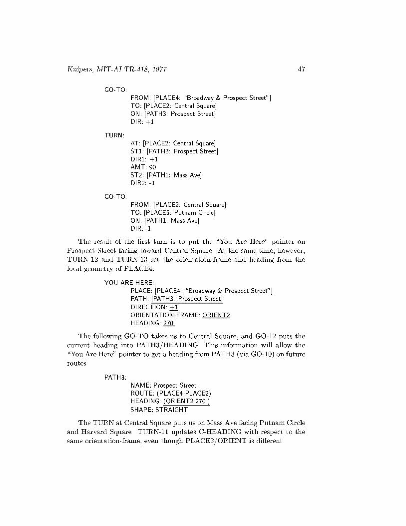
Kuipers, MIT-AI TR-418, 1977. 47
GO-TO:FROM: [PLACE4: \Broadway & Prospect Street"]TO: [PLACE2: Central Square]ON: [PATH3: Prospect Street]DIR: +1
TURN:AT: [PLACE2: Central Square]ST1: [PATH3: Prospect Street]DIR1: +1AMT: 90.ST2: [PATH1: Mass Ave]DIR2: -1
GO-TO:FROM: [PLACE2: Central Square]TO: [PLACE5: Putnam Circle]ON: [PATH1: Mass Ave]DIR: -1
The result of the �rst turn is to put the \You Are Here" pointer onProspect Street facing toward Central Square. At the same time, however,TURN-12 and TURN-13 set the orientation-frame and heading from thelocal geometry of PLACE4:
YOU ARE HERE:PLACE: [PLACE4: \Broadway & Prospect Street"]PATH: [PATH3: Prospect Street]
DIRECTION: +1ORIENTATION-FRAME: ORIENT2HEADING: 270.
The following GO-TO takes us to Central Square, and GO-12 puts thecurrent heading into PATH3/HEADING. This information will allow the\You Are Here" pointer to get a heading from PATH3 (via GO-10) on futureroutes.
PATH3:NAME: Prospect StreetROUTE: (PLACE4 PLACE2)HEADING: (ORIENT2 270.)
SHAPE: STRAIGHT
The TURN at Central Square puts us on Mass Ave facing Putnam Circleand Harvard Square. TURN-11 updates C-HEADING with respect to thesame orientation-frame, even though PLACE2/ORIENT is di�erent.

48
YOU ARE HERE:PLACE: [PLACE2: Central Square]
PATH: [PATH1: Mass Ave]
DIRECTION: -1ORIENTATION-FRAME: ORIENT2HEADING: 0.
Finally, the GO-TO to Putnam Circle allows GO-12 to give a headingto PATH1.
PATH1:NAME: Mass AveROW:(PLACE1 PLACE2 PLACE3)
(PLACE5 PLACE2)HEADING: (ORIENT2 180.)
SHAPE: STRAIGHT
Simulating observations
In the previous chapter, all contact between the TOUR model and the worldit tries to describe takes place through the GO-TO and TURN instructions,which provide information about the topology and the local geometry ofintersections. In order to have position and orientation knowledge to rep-resent, however, we need to simulate additional processes whereby peopleextract information from the environment. People �nd it quite easy to es-timate the distance travelled (perhaps inaccurately), according to the timeor e�ort required. People can also see landmarks in the distance, and incor-porate information about distance and direction into their mental maps.
Estimating distance while travelling is simulated in the TOUR modelby adding a distance descriptor to the GO-TO instruction. GO-TO/DISTis �lled automatically by a process conceptually separate from the TOURmachine. The value of GO-TO/DIST is an integer number of arbitrarydistance-units, corresponding roughly to distance in meters. fNote Quanti-tiesg
G0-TO:FROM: hplaceiTO: hplaceiPATH: hpathiDIR: hdirectioniDIST: hintegeri
Observing the positions of distant landmarks is simulated in the TOURmodel by the NOTICE instruction.

Kuipers, MIT-AI TR-418, 1977. 49
NOTICE:FROM: hPLACEiPATH: hPATHiDIR: hdirectioniREMOTE: hPLACEiDISTANCE: hdistance in unitsiHEADING: hegocentric heading in degreesi
The NOTICE instruction says that, if the traveller is at the given place,path, and direction, then the remote place can be observed at the givendistance and heading. The heading is de�ned with respect to egocentriccoordinates within which the heading of the observer is 0.
Each of these simulated observations provides information about the en-vironment to the TOUR machine. The information is provided within asingle TOUR instruction. Any meaning it acquires beyond that must comefrom the way the TOUR machine �ts it into other structures. The psycho-logically unrealistic representation of distance as an integer is a defect in thissimulation. However, the structure of the TOUR model is not dependenton the representation of distance, so replacing the integer representationwith one more psychologically valid would e�ect its behavior but not itsunderlying structure
Representing position
The position of one place from another consists of two parts: its distance andits heading. The heading must be speci�ed with respect to some referencesystem. We can use the ORIENTATION-FRAME which de�nes the localgeometry of a PLACE for the positions of remote PLACEs as viewed fromthis one. The position of a remote PLACE, perhaps obtained from a NO-TICE instruction, is stored in the VIEW property of a PLACE description,with other positions, as a triple:
( hremote-placei hheadingi hdistancei )
The heading is with respect to the ORIENTATION-FRAME kept inPLACE/ORIENT, and so is compatible with the headings of streets radiat-ing from the intersection. The following productions execute the NOTICEinstruction to compare its observational information with PLACE/VIEW.
NOTICE-1: Check that NOTICE/PLACE, NOTICE/PATH, and NOTICE/DIRmatch C-PLACE, C-PATH, and C-DIR. If not, complain and dismiss.
NOTICE-2: If C-ORIENT and C-HEADING are supplied, and if C-ORIENTmatches C-PLACE/ORIENT, then look up the posiition of NOTICE/REMOTE
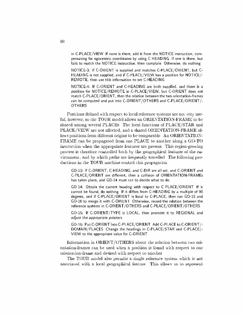
50
in C-PLACE/VIEW. If none is there, add it from the NOTICE instruction, com-pensating for egocentric coordinates by using C-HEADING. If one is there, butfails to match the NOTICE instruction, then complain. Otherwise, do nothing.
NOTICE-3: If C-ORIENT is supplied and matches C-PLACE/ORIENT, but C-HEADING is not supplied, and if C-PLACE/VIEW has a position for NOTICE/-REMOTE, then use this information to set C-HEADING.
NOTICE-4: If C-ORIENT and C-HEADING are both supplied, and there is aposition for NOTICE/REMOTE in C-PLACE/VIEW, but C-ORIENT does notmatch C-PLACE/ORIENT, then the relation between the two orientation-framescan be computed and put into C-ORIENT/OTHERS and C-PLACE/ORIENT/-OTHERS.
Positions de�ned with respect to local reference systems are not very use-ful, however, so the TOUR model allows an ORIENTATION-FRAME to beshared among several PLACEs. The local functions of PLACE/STAR andPLACE/VIEW are not a�ected, and a shared ORIENTATION-FRAME al-lows positions from di�erent origins to be comparable. An ORIENTATION-FRAME can be propagated from one PLACE to another along a GO-TOinstruction when the appropriate features are present. This region-growingprocess is therefore controlled both by the geographical features of the en-vironment, and by which paths are frequently travelled. The following pro-ductions in the TOUR machine control this propagation.
GO-13: If C-ORIENT, C-HEADING, and C-DIR are all set, and C-ORIENT andC-PLACE/ORIENT are di�erent, then a collision of ORIENTATION-FRAMEshas taken place, and GO-14 must run to decide what to do.
GO-14: Obtain the current heading with respect to C-PLACE/ORIENT. If itcannot be found, do nothing. If it di�ers from C-HEADING by a multiple of 90degrees, and if C-PLACE/ORIENT is local to C-PLACE, then run GO-15 andGO-16 to merge it with C-ORIENT. Otherwise, record the relation between thereference systems in C-ORIENT/OTHERS and C-PLACE/ORIENT/OTHERS.
GO-15: If C-ORIENT/TYPE is LOCAL, then promote it to REGIONAL andadjust the appropriate pointers.
GO-16: Put C-ORIENT into C-PLACE/ORIENT. Add C-PLACE to C-ORIENT/-DOMAIN/PLACES. Change the headings in C-PLACE/STAR and C-PLACE/-VIEW to the appropriate value for C-ORIENT.
Information in ORIENT/OTHERS about the relation between two ori-entation-frames can be used when a position is found with respect to oneorientation-frame and desired with respect to another.
The TOUR model also permits a single reference system which is notassociated with a local geographical feature. This allows us to represent

Kuipers, MIT-AI TR-418, 1977. 51
positions de�ned with respect to the cardinal directions. Since many head-ings are known with respect to both the cardinal directions and a localorientation frame, it is often easy to compute the relationship of di�erentorientation frames through the cardinal directions. This is represented justas PLACE/VIEW is, but the position triple is kept in PLACE/CARDINAL.
At this point, the full form of the PLACE description is:
PLACE:NAME: hnameiON: hlist of PATHsiSTAR: hlocal geometry datastructureiCONNECT: hlist of pairs: (PLACE route) iORIENT: hORIENTATION FRAMEi
VIEW: hlist of triples (PLACE heading distance) i
CARDINAL: hlist of triples: (PLACE heading distance) i
IN: hlist of REGIONsi
Computing position from a route
One common-sense method for discovering the position of one place fromanother is by a process of \dead reckoning" while travelling from one to theother. Dead reckoning is a process of integrating along a route by takinginto account the distances and turns along the route to maintain the currentrelative position from the starting place. Thus, at any point along the route,the current relative position from the starting point is known.
This is accomplished in the TOUR model by translating the distanceand direction covered by each GO-TO instruction from its natural polarcoordinates into rectangular coordinates with respect to the reference systemof the starting place. The rectangular coordinates of the current positionare kept in two temporary elements of the \You Are Here" pointer, calledC-X and C-Y.
GO-17: It C-X, C-Y, C-HEADING, and GO-TO/DIST are all supplied, thentranslate C-HEADING and GO-TO/DIST into rectangular coordinates and up-date C-X and C-Y.
GO-18: If C-X and C-Y are set, but either C-HEADING or GO-TO/DIST isempty, then elear C-X and C-Y.
Although this is an antecedent computation, it is performed to solveproblems posed by questions like \Where is Harvard Square from here?"When such a problem is posed, C-X and C-Y are set up in the \You Are

52
Here" pointer and a route is followed for the side-e�ect of setting C-X and C-Y to the relative position of the destination from the source of the route. Atthe end of the route, C-X and C-Y are converted back into polar coordinatesand the position is stored in PLACE/VIEW or PLACE/CARDINAL.
Most modern navigation techniques depend on this method, but withinstruments designed to supply accurate headings and distance readings,and with precise trigonometric calculations. Many of the inaccuracies in hu-man dead reckoning are due to inaccuracies in angle and distance estimates,and to the failure to compensate correctly for curved paths. Furthermore,the human common-sense method for integrating the segments of the routesurely uses something other than precise trigonometric tables. The TOURmodel uses exact trigonometry for the lack of a better theory of \common-sense trigonometry." It seems plausible, however, that reasonable estimatescould be made by matching any such problem to the closest of a small setof familiar triangles.
On iconic mental images
There has been much controversy about the possibility of storage of infor-mation as an iconic mental image capable of operations isomorphic to thosewhich are performed on physical images. (See Shepard and Metzler (1971)and Pylyshyn (1973).) An important argument against the long-term stor-age of iconic mental images is the vast amount of storage that would berequired, perhaps even overwhelming the enormous capacity of human long-term memory. However, these arguments do not apply to the possibility of arelatively small grid (perhaps 50 by 50 points) that is used, not for long-termstorage, but for intermediate computations. This is similar to what Minsky(1975) called the \global space frame."
Relative position computations or array rotations could potentially beperformed by translating information from a property-value description tothe grid representation, using the grid to measure relative position or per-form the rotation, and translating the result back to the property-value formfor permanent storage. This method would be computationally much moreeconomical than performing the same operation directly on the original de-scription.
The fundamental operations required of such a grid are: 1) placing twopoints with a given relative position in rectangular or polar coordinates,2) reading the relative position of two given points in either rectangular orpolar coordinates, and 3) mapping each grid-point to its successor under a
Kuipers, MIT-AI TR-418, 1977. 53
�xed elementary rotation. The �rst two properties permit relative positioncomputations and rectangular-polar conversions, and the third permits arrayrotation in �xed steps.
Further psychological experimentation is required to establish the actualparameters of such a device. Perhaps it can be shown that one of the aboveoperations is not used, or that an additional one is present. The resolution ofthe grid could also be somewhat di�erent. The results of Just and Carpenter(1976) suggest that the unit of elementary rotation is about 50 degrees.
Summary
The orientation frame provides a frame of reference for the de�nition ofrelative positions. These frames of reference are initially con�ned to repre-senting the positions of places as viewed from a single vantage point. Theygain their power, however, from being shared among a number of di�erentplaces, so relative positions from di�erent origins can be compared. Theexample above shows how the local inferences that maintain the heading inthe \You Are Here" pointer can result in the propagation of an orientationframe to additional places along a route. Beyond this local propagation oforientation frames, dead reckoning provides a method for discovering therelative positions of the source and destination of a route. Further com-putations with relative positions might be facilitated by an expert arrayprocessor which acts something like an iconic mental image. Other than theiconic array, all of these aspects of the TOUR model have been implemented.

54

Chapter 4
Dividing Boundaries
And God said, Let there be light: and there was light. And Godsaw the light, that it was good: and God divided the light fromthe darkness. And God called the light Day, and the darknesshe called Night. And the evening and the morning were the �rstday.
And God said, Let there be a �rmament in the midst of the wa-ters, and let it divide the waters from the waters. And God madethe �rmament, and divided the waters which were under the �r-mament from the waters which were above the �rmament: and itwas so. And God called the �rmament Heaven. And the eveningand the morning were the second day.
. . .
And God said, Let there be lights in the �rmament of the heavento divide the day from the night; and let them be for signs, forseasons, and for days, and years . . .And God set them in the�rmament of the heaven to give light upon the earth, and to ruleover the day and over the night, and to divide the light from thedarkness: and God saw that it was good. And the evening andthe morning were the fourth day.
[Genesis 1:3-8, 14, 17-19.]
Dividing boundaries are important to make distinctions where none ex-isted without them. Thus they are important not just to mark the outlinesof something, but to provide it with internal structure. Streets that providea skeletal structure to a city are acting as dividing boundaries just as muchas those which outline it.
55

56
Dividing boundaries also provide useful partial descriptions of position.For example, it is quite natural for me, sitting in my o�ce at MIT, todescribe the location of the Cambridge Public Library as \beyond ProspectStreet, on this side of Mass Ave, between Broadway and Cambridge Street,closer than Quincy Street, past Ellery Street," and so on. With each phraseI add more information to my partial speci�cation of the position.
Furthermore, such a description can be very helpful in �nding a routeshould I want to go to the Cambridge Public Library. Getting to ProspectStreet is progress in the right direction, and I should stay between Broadwayand Cambridge Street. If I cross Mass Ave or Quincy Street I have gone toofar and should turn back. These clues do not specify the paths that shouldmake up my route, but they give criteria for progress and therefore couldbe used to guide my search.
Elle
ry S
t.
Pro
spec
t St.
Mai
n St
.
KendallSquare
XTechSquare
X
C.P.L.
Qui
ncy
Cambridge St.
Broadway
Mass Ave.
In each clause of this description, a street acts as a boundary betweentwo regions. Considering a street as a directed line, one can specify whethera place is to the right or the left of the street. This is a small piece ofinformation, and easily acquired. If a route that includes the street goes tothe place in question, and the turn made from the street is known, then theplace can be located with respect to the street, no matter how tortuous theintervening route. (Provided, of course, that the street does not cross backover itself.)

Kuipers, MIT-AI TR-418, 1977. 57
The position of a given place is very well speci�ed indeed when its loca-tion is known with respect to many di�erent boundary streets. They providea very rich collection of states of partial knowledge about the position of aplace. Furthermore, this qualitative knowledge is very resistant to error,unlike the more quantitative position descriptions of the last chapter.
The area over which a given boundary is meaningful varies considerably.Almost any place in Cambridge can be related to Mass Ave in most people'scognitive maps. Portland Street, however, has meaning only in a smallregion near Tech Square. The extent of such application is not de�ned bysome second, outer boundary, but only by the travel patterns which arelikely to cause boundary relations to be inferred and represented. Thus,position with respect to Mass Ave is widely known because Mass Ave isimportant to routes involving many di�erent parts of Cambridge. PortlandStreet is only important to travel within the neighborhood of Tech Square,and so its knowledge spreads no farther.
Conversely, boundary relations are used in the selection of routes. There-fore, since Mass Ave is involved in describing the positions of many places,it will be encountered very frequently in the route-�nding process. PortlandStreet will not. It is the number of relationships with other places that de-termines what is a main street, not physical size. It is a characteristic of pooror non-existent urban planning when these two concepts diverge, resultingin tiny, congested main streets and magni�cent unused boulevards.
Boundaries are also very useful for the exploration of unknown territory.If a traveller knows his own heading and the heading of a familiar boundary(with respect to the same orientation frame), and knows which side of theboundary he is on, he can always steer in a direction which will bring him,sooner or later, back to familiar territory. This technique is available evenin the complete absence of a cognitive map of the actual territory beingexplored.
Naturally, one-dimensional geographical features other than streets canfunction as boundaries. Rivers, railroad tracks, limited-access highways andother barriers often have this role in a city. The principles that are out-lined below for streets apply equally well to other boundaries, except thattheir properties are not discovered by physical travel along them. The imple-mented version of the TOUR model considers streets as the only boundaries,but there is nothing in the representation which prohibits the inclusion ofbarriers as well.

58
Representing position with dividing boundaries
Since a PATH has a one-dimensional orientation, we can face its +1 direc-tion and distinguish between the \right" region and the \left" region, kept inPATH/RIGHT and PATH/LEFT, respectively. The position of a PLACE ispartially speci�ed by putting it into the appropriate REGION. A REGIONin one of these properties has a TYPE of BOUNDED, and a BOUNDARYproperty which describes its boundary. The BOUNDARY property of a RE-GION description contains a set of pairs (PATH DIRECTION), and meansthat the region is on the right of that PATH when travelled in that DIREC-TION. (The current implementation does not explore regions bounded bymore than one path, though the representation can describe them.) The fullREGION and PATH descriptions are now:
REGION:TYPE: hone of fORIENT, BOUNDEDg iBOUNDARY: hlist of pairs: (path +1/�1) i
ORIENT: hORIENTATION-FRAMEiPLACES: hlist of PLACEsiPATHS: hlist of PATHsi
PATH:NAME: hname-frameiROW: hpartial order data-structureiHEADING: hlist of pairs: (ORIENTATION-FRAME HEADING) iSHAPE: hdescriptive tag, e.g. STRAIGHTiIN: hlist of REGIONsiRIGHT: hREGIONi
LEFT: hREGIONi
A REGION which is in PATH/RIGHT or PATH/LEFT may occasion-ally be referred to as a \side-region" of that PATH.
Acquiring boundary relations
The TURN instruction is crucial to the way the TOUR machine discovers aboundary relation between a place and a path. If a TURN is either precededor followed by a GO-TO instruction involving a place not on the path, thenthe direction of travel on the street and the amount of the turn determinewhich side region that place belongs in. These inference rules, then, mustexamine two TOUR instructions: the current one and the previous one. In

Kuipers, MIT-AI TR-418, 1977. 59
e�ect, these two instructions focus attention on a small part of the cognitivemap which is examined for the boundary relation.
The two diagrams below illustrate this situation with a path P, travelledin the +1 direction, and a place X, not on P. In the �rst case, a right turn isfollowed by a GO-TO to X. In the second case, a GO-TO from X is followedby a right turn. In both cases, X belongs in P/RIGHT.
^ ^
! X +1P
+1
P
!
X
TURN ) GO-TO GO-TO ) TURN
If the current instruction is a GO-TO and the previous one is a TURN,then we may try to determine the relation between TURN/ST1 and GO-TO/TO.
GO-19: If the preceding instruction was a TURN onto GO-TO/PATH, withTURN/AMT and TURN/DIR1 speci�ed, then decide which side-region of TURN/-ST1 should contain GO-TO/TO, and put it there.
Similarly, if the current instruction is a TURN, preceded by a GO-TO,the relation is to be found between GO-TO/FROM and TURN/ST2.
TURN-l5: If the previous instruction was a GO-TO to TURN/AT, and TURN/-AMT and TURN/DIR2 are both speci�ed, then decide which side-region ofTURN/ST2 should contain GO-TO/FROM, and put it there.
In both of these cases, the travelling instruction could potentially be aTAKE rather than a GO-TO. The relation remains true for arbitrarily longroutes, provided that they do not cross back over the dividing street. Theimplemented version, however, uses only the productions listed.
Route-�nding with dividing boundaries
There is a simple route-�nding heuristic which is based on the partial posi-tion knowledge provided by dividing boundaries.

60
To �nd a route between two places A and B, �nd a path S such that A and Bare known to lie on opposite sides of S. Then �nd a path from A to S, anotherfrom S to B, and travel along S to connect the two intersections.
This is basically the \stepping-stone" heuristic of looking for interme-diate subgoals, but recognizing that a one-dimensional boundary makes abetter stepping-stone than a zero-dimensional point.
A
B
S
This heuristic can be extended by removing, the restriction that S beselected so that A and B lie on opposite sides. The consequence of thisis that routes will be found that are somewhat roundabout but which usemajor connecting streets, since major streets are most frequently known asboundaries.
The method can be further modi�ed to be recursive. Suppose only oneof the subgoals is achieved, and we �nd a path from A to S, intersecting Sat C. (See �gure below.) Then we can pose the new problem of �nding aroute from C to B, which may be solved by recourse to yet another dividingstreet (in this case, T).

Kuipers, MIT-AI TR-418, 1977. 61
.
A
C
T
S
B
In order to implement these heuristics, a problem remains: given twoplaces, how do we �nd a dividing street which has a boundary relation withboth of them? Here is where the TOUR model �rst indulges in a searchtechnique. For each of the two places, A and B, consider the regions of typeBOUNDED in their IN properties. These two lists can be compared to �ndpairs of regions, one from each list, which share a boundary street. Thestraightforward approach is to examine all possible pairs to see if they sharea boundary street. This approach examines as many pairs as the productof the lengths of the two lists. A slightly cleverer approach is:
Put a temporary mark on the street bounding each BOUNDED region from A/-IN. Then examine each BOUNDED region in B/IN, to see if its boundary isalready marked. If so, this is a shared dividing boundary. When the search isconcluded, erase the marks.
This technique examines the sum of the two lists, rather than the prod-uct, and is therefore not an expensive operation.
Consider using the dividing boundary strategy to �nd a route from In-man Square in Cambridge to the entrance to the Mass Pike, on StorrowDrive in Allston. (See the map below.) I present the example below inEnglish because it should be clear how it translates into formal PLACE,PATH, and REGION descriptions.
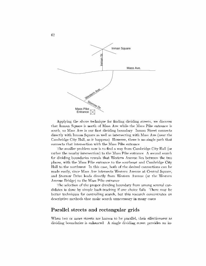
62
Inman Square
Inm
an S
t.Western Ave.
Storrow Dr.
Mass Ave.
EntranceMass Pike
Applying the above technique for �nding dividing streets, we discoverthat Inman Square is north of Mass Ave while the Mass Pike entrance issouth, so Mass Ave is our �rst dividing boundary. Inman Street connectsdirectly with Inman Square as well as intersecting with Mass Ave (near theCambridge City Hall, as it happens). However, there is no single path thatconnects that intersection with the Mass Pike entrance.
The smaller problem now is to �nd a way from Cambridge City Hall (orrather the nearby intersection) to the Mass Pike entrance. A second searchfor dividing boundaries reveals that Western Avenue lies between the twoplaces, with the Mass Pike entrance to the southeast and Cambridge CityHall to the northwest. In this case, both of the desired connections can bemade easily, since Mass Ave intersects Western Avenue at Central Square,and Storrow Drive leads directly from Western Avenue (at the WesternAvenue Bridge) to the Mass Pike entrance.
The selection of the proper dividing boundary from among several can-didates is done by simple back-tracking if one choice fails. There may bebetter techniques for controlling search, but this research concentrates ondescriptive methods that make search unnecessary in many cases.
Parallel streets and rectangular grids
When two or more streets are known to be parallel, their e�ectiveness asdividing boundaries is enhanced. A single dividing street provides an in-

Kuipers, MIT-AI TR-418, 1977. 63
termediate \stepping-stone" for a route-�nding problem. When a bundle ofparallel dividing streets is available, it provides a set of stepping stones, tobe used individually or in a sequence on the way to the goal. When twoorthogonal bundles of parallel streets are available, the positions of sourceand goal are very precisely speci�ed in both dimensions. Orthogonal bun-dles also ensure that getting from one parallel street to another in the samebundle is simple, so that a route can be found very easily between any twoplaces within the grid.
A bundle of parallel streets provides a global view of their relationswhich captures their local properties as boundaries, and also permits furtherinferences from the relations of their side-regions. In this sense a parallelbundle is similar to the order description a PATH has of a set of places: theyboth collect local relations into a globally useful structure. When a place islocated with respect to one path, the parallel bundle extends this relationto other paths as well.
Acquiring parallel relations
A parallel relation is de�ned between pairs of PATHs. It is initially observedand represented when a GO-TO directs attention to the pair of cross-streetsat its endpoints. If they have the same heading, with respect to the sameorientation-frame, they are described as parallel. Of course, this is a localdescription, and the same streets can intersect or diverge at some otherpoint.
If two streets are parallel, the fact is represented in the PARALLELproperty of their PATH descriptions. If P1 is parallel to P2, and their +1directions have the same heading, then (P2 +1) is put into P1/PARALLEL,and vice versa. If their +1 directions have opposite headings, then (P2 �1)and (P1 �1) are stored. Which sides the two paths are of each other isrepresented by putting them in each others' side-regions.
GO-20: Let C1 and C2 be the only cross streets at GO-TO/FROM and GO-TO/-TO, respectively. If the headings of both C1 and C2 can be found with respectto the same ORIENTATION-FRAME, and if they are equal, put (C1 +1) intoC2/PARALLEL, and (C2 +1) into C1/PARALLEL. It they are opposite, put (C1�1) into C2/PARALLEL, and (C2 �1) into C1/PARALLEL.
At this point, the full form of a PATH description is:

64
PATH:NAME: hname-frameiROW: hpartial order data-structureiHEADING: hlist of pairs: (ORIENTATION-FRAME HEADING) iSHAPE: hdescriptive tag, e.g. STRAIGHTiRIGHT: hREGIONiLEFT: hREGIONiIN: hlist of REGIONsiPARALLEL: hlist of pairs: (PATH +1/�1) i
The parallel bundle
As represented in PATH/PARALLEL and the side-regions of the PATH, therelations among parallel streets are distributed and relatively inaccessible.In order to achieve the global and more useful parallel bundle representa-tion, we need a process which explores sets of parallel streets, following therelations between pairs of streets, and gathers them into a parallel bundle.
The parallel bundle represents two relations among parallel streets, inaddition to the fact that they are parallel. First, it describes each path asa pair (PATH DIRECTION), where DIRECTION is +1 or �1 according towhether the PATH runs the same way or the opposite way as an arbitrarystandard in the bundle. Second, it orders the paths in the bundle, withthe order running from left to right when facing in the bundle's +1 direc-tion. These two kinds of information are necessary in order to know therelations among the side-regions of the streets in the bundle. The bundleis held in the BUNDLE property of a REGION description whose TYPE isSTRUCTURED. A grid is described by two STRUCTURED REGIONs.
REGION:TYPE: hone of fORIENT, BOUNDED, STRUCTUREDg iBUNDLE: hpartial ordered set of pairs: (PATH +1/�1) i
BOUNDARY: hlist of pairs: (PATH +1/�1) iORIENT: hORIENTATION-FRAMEiPLACES: hlist of PLACEsiPATHS: hlist of PATHsi
The following bundle of parallel streets has two possible representations,depending on which street was chosen to establish the overall DIRECTIONof the bundle. The +1 direction on each street is in the direction of thearrow. The two representations are functionally identical for inferences andproblem-solving.

Kuipers, MIT-AI TR-418, 1977. 65
�
-
-
-A
B
C
D
(( (A +1) (( (D �1)(B +1) (C +1)(C �1) (B �1)(D +1) )) (A �1) ))
The process of gathering isolated parallel relations between PATHs intoa parallel bundle is initiated when the PARALLEL property of some PATHdescription contains more than one street. The gathering operation estab-lishes the direction of the bundle as the +1 direction of the original street.Then it follows the PARALLEL links among PATHs, creating (PATH DI-RECTION) pairs so that each pair faces the direction of the bundle. Theside-regions of each PATH are examined to provide the ordering on theparallel streets. Finally, the fragments of order are merged by the partialorder mechanism we have seen ordering PLACEs on a PATH. A REGIONdescription is created to hold the partial order datastructure which de�nesthe parallel bundle.
Exploring unknown territory
Qualitative knowledge of dividing boundaries can be of great value to thetraveller in unfamiliar territory, where he has no cognitive map of the streetnetwork. He can always return to familiar territory if he knows what sideof a familiar path he is on, what the heading of that path is, and if he canmaintain knowledge of his own heading with respect to that of the path.He can maintain knowledge of his own heading by careful attention to theamounts of turns and to the gradual e�ects of curving streets. Returning tothe familiar boundary street is simply a matter of choosing paths that leadin roughly the correct direction whenever he is faced with a choice. Thisstrategy is very resilient in the face of errors, since his goal is accessible bya wide range of headings.
The primary task required of the explorer, then, is to maintain his head-ing. This is substantially easier if the new area is organized as a rectangulargrid, since his heading then has only four possible values and there are no

66
curving streets. He can also estimate his distance from his goal in terms ofthe number of intervening parallel streets, in case he has retained that muchinformation about the street network.
A second way of maintaining his heading is by reference to a distant andconspicuous landmark. If he has lost track of the cumulative change to hisheading from the route he is following, an observation of the landmark servesto reorient him: i.e. allow him to establish his heading with respect to hisorientation-frame. In Boston, the Prudential Building and the John HancockTower often play this important role. This use of the orientation-frame,centered about a visible landmark, is useful for exploration but, withoutknowledge of the street network, cannot be used to represent the positionsof currently invisible places.
Grid-based distortions
Since the description of an area in terms of parallel streets and grid struc-tures is so e�ective, it is hardly surprising that many people introduce enor-mous distortions into the geography in order to make it conform to sucha pattern. Because these representations are so resilient in the face of er-rors, however, the distortions do not greatly reduce their e�ectiveness forroute-�nding. It is only in extremely anomalous cases that distortions ina person's cognitive map result in geographical paradoxes that disturb himand lead him along incorrect routes.
The most common distortions are 1) describing an intersection as a rightangle when it is not, 2) describing a street as straight when it curves, and 3)describing two streets as parallel when they converge or diverge. All three ofthese are topological distortions of the street network which have no e�ectat all on the topological properties discussed in Chapter 2. They have verylittle e�ect on the roles the streets play as boundaries between regions, andeven as constituents of parallel bundles and grids, because their topologicalproperties are still the most important ones. Noticeable inaccuracies resultfrom these distortions when routes are followed to estimate relative positionsusing the methods discussed in Chapter 3. A careful examination of theinference rules which make up the TOUR machine shows how little they area�ected by metrical errors, as long as topological correctness is preserved.
Thus we get the curious fact that an incorrect description of geographicalreality is more e�ective than a correct one, because it abstracts out themetrical features and leaves the topological features which permit powerfuldescriptions and problem-solving techniques. Of course, extreme anomalies
Kuipers, MIT-AI TR-418, 1977. 67
will cause geographical paradoxes to arise. Fortunately (for this research),Boston contains many such extreme anomalies, and the cognitive maps ofBoston residents are correspondingly full of geographical paradoxes.
For example, Beacon Street and Commonwealth Avenue are essentiallyparallel over most of their length, but they switch sides by crossing at Ken-more Square. Images of Cambridge di�er as to whether Mass Ave andMemorial Drive are parallel or perpendicular, according to the end of Cam-bridge at which they were �rst encountered. Perhaps the most famous geo-graphical paradox in Boston arises from the fact that Boston Common has�ve sides while each corner appears square. This leads to incorrect estimatesof the headings of the bounding streets, which in turn eliminates the spaceoccupied by whole sectors of the city.
Such paradoxes aside, the use of default values like straight streets andright-angle turns is justi�ed on practical grounds, if not those of strict ac-curacy. A description which adheres to the defaults is more economical tocreate and to store and most inferences that operate on it are not adverselya�ected by the inaccuracies. Furthermore, a description of an area in termsof parallel bundles and grid structures is more likely if the places and pathsare described as regular. That structure confers so much problem-solvingpower that minor carelessness with the facts appears justi�ed.
Summary
The role of a one-dimensional geographical feature as a dividing bound-ary underlies a number of important parts of the cognitive map. Dividingboundaries are the basis of an important kind of partial knowledge of posi-tion. They can be recognized easily from travel along well-speci�ed routes,and they can be easily applied to route-�nding problems. When a num-ber of such boundaries are gathered into a parallel bundle, their power fordescribing positions and specifying routes is greatly increased. Two orthog-onal parallel bundles constitute the grid representation which is so useful inorganizing urban geography. This derivation is important because it showsthat the grid representation is not a primitive element of the cognitive map,but is built from simpler elements with richer states of partial knowledge.The dividing boundary and the orientation frame can also be used to de-�ne a strategy for exploring areas where the topology of the street networkis still unknown. Except for the exploration strategy, the use of dividingboundaries is completely implemented in the TOUR model.

68
Chapter 5
Regions
\Rather than a single comprehensive image for the entire envi-ronment, there seemed to be sets of images, which more or lessoverlapped and interrelated. They were typically arranged in aseries of levels, roughly by the scale of area involved, so that theobserver moved as necessary from an image at street level to lev-els of a neighborhood, a city, or a metropolitan region."(pp. 85-86)
\The physical characteristics that determine districts are the-matic continuities which may consist of an endless variety ofcomponents: texture, space, form, detail, symbol, building type,use, activity, inhabitants, degree of maintenance, topography. Ina closely built city such as Boston, homogeneities of facade|material, modeling, ornament, color, skyline, especially fenes-tration|were all basic clues in identifying major districts. Bea-con Hill and Commonwealth Avenue are both examples. Theclues were not only visual ones: noise was important as well. Attimes, indeed, confusion itself might be a clue, as it was for thewoman who remarked that she knows she is in the North End assoon as she feels she is getting lost." (pp. 67-68)
[Lynch, 1960.]
Regions play an important role in the cognitive map by allowing groupsof geographical features to be referred to collectively. First, they allow setsof geographical features to be referred to as units, for e�ective indexing andeconomical information storage. Second, they provide levels of abstraction,so that references to the geography can take place with di�erent amounts
69

70
of detail. They also provide a linguistic context for such context-dependentterms as \near" and \far".
Storage economy is achieved by allowing certain pieces of informationto be reconstructed when required, rather than being represented explicitly.When similar properties are shared by a number of geographical places, itcan be convenient to collect the places into regions and store the propertieswith the regions. The properties of the places can then be reconstructedwhen needed. For example, the fact that the West Coast of the United Statesis 3000 miles west of the East Coast may be stored explicitly. When I ask thedistance from MIT to Stanford University, the fact that they are (roughly)3000 miles apart can be reconstructed from the more general assertion andtheir containment relations with the two coasts. The same general assertionreplaces countless similar assertions about the distance between particularplaces on the two coasts. An even more common example is the use of trunkroutes to connect large regions. Routes connecting places in two regions canbe constructed quite easily by �rst selecting the appropriate trunk route,and then connecting its endpoints with the desired source and goal.
Regions also function as levels of abstraction in describing the geography.I may describe my current location in a number of di�erent ways: I am atMIT, in Cambridge, on the East Coast, and so on, depending on what I wantto associate with that description. A generally useful piece of information isoften best represented as relating two places which are in fact abstractions oflarge regions. Thus, when I say, \The West Coast is 3000 miles west of theEast Coast," I am treating the two large regions as abstract places, capableof being related by a well-de�ned distance. Similarly, a trunk route fromNew England to Northern California might be stated as, \Take Interstate90 from Boston to Cleveland. Then turn onto Interstate 80 and follow itto San Francisco." The route is stated at one level of abstraction, treatingcities as simple locations, and it is indexed at another level: the regions NewEngland and Northern California.
These levels of abstraction re ect the representation of information in thecognitive map, not simply the attempt to express the relations in English.However, there are linguistic e�ects for which the use of regions is important.For example, whether two places are described as \near" or \far" is depen-dent on the context provided by some region. Also, the way a place will bedescribed in response to a question is dependent on the circumstances of thequestion.
In this chapter, regions are treated primarily as levels of abstraction forindexing and summarizing frequently used information. However, they canalso be used for their spatial extent and internal structure. This facet of the
Kuipers, MIT-AI TR-418, 1977. 71
region description is linked with representations of visual space that be usedin map reading, and with the use of the iconic mental image for inference(Chapter 3). When a region is treated as an extended shape, several newoperations become meaningful. It becomes possible to subdivide a regioninto subregions: e.g. Western Massachusetts, or the \thumb" of Michigan.It also becomes possible to describe the position of a place as \central" or\in the northwest corner" with respect to the region.
The use of regions as levels of abstraction has been completely imple-mented in the TOUR model. The implementation supports the retrievalof general trunk routes for speci�c route-�nding problems and the shift inlevels of detail that is required to �ll in the gaps at the endpoints and makea complete route. The use of a region as an extended shape has not yet beenimplemented.
A hierarchy of regions
Rumelhart (1974) explored the use of a collection of containing regions forsummarizing information and providing useful levels of abstraction for ex-planation. His \ROOM Theory" was proposed to explain the answers to\where" questions and the use of relative distance terms like \near" and\far." The ROOM is the smallest region that contains the reference po-sition of the conversation (usually its location) and the places of interest.\Near" and \far" are comparisons of the requested distance with the sizeof the ROOM. This theory explains why, from Rumelhart's position in LaJolla, the San Diego airport is far away, while New York and Boston arenear each other. The context-dependent answer to a \where" question isthe least precise region that is still informative: the largest region whichis smaller than the ROOM, and which contains the place of interest butexcludes the reference position.
Stevens (1976) has tested the ability of a model of this sort to accountfor certain psychological phenomena. He found that it explained a classof common position distortions, the relative di�culty in answering pairs ofposition-estimation questions, and the facilitation of one such question bya previous one about related parts of the region structure. This is the onlyresearch I know of that is su�ciently detailed to distinguish among alternateaccessing strategies for a hierarchy of regions. The design of the operatorspresented below for searching the region structure is consistent with Stevens'results.
As Lynch (1960) notes at the beginning of this chapter, the character-
72
istics which de�ne a region are often not spatial in the sense of large-scalespace used in this paper. Furthermore, most named regions are learned byexplicit telling, either in school or in response to questions like \Where isthe South End, anyway?" Thus, in this chapter we will not be concernedwith the creation of regions, but only with the way that they relate to therest of the cognitive map.
Most of the regions that we use in this way have names, and can bereferred to explicitly. However, occasionally a region which is clearly de�nedby some perceived property may not have a name, but will have the samerole as a named regions in the cognitive map. Important unnamed regionsare often regions in the sense of Chapter 4, where they are de�ned by theirboundaries, like \the other side of the tracks," or \the area between MassAve and the river." An important area for further research is regions whichcombine the properties discussed in chapters three, four, and �ve.
Representing the regions
Regions are related by containment. In most of the familiar cases, such ascities, states, and sections of the country, regions have well-known namesand politically de�ned boundaries. These regions fall into a clear hierarchicalstructure by containment. For example, Boston and Spring�eld are bothcities in Massachusetts, while Hartford and New Haven are in Connecticut.Massachusetts and Connecticut are both in New England, which is in theEast Coast, which is in the United States, which is in North America, andso on. In this case, the set of containing regions, or \superiors", of a givenplace can be represented as a sequence from the smallest to the largest.
Regions can overlap without containment, however. A region like theBerkshire area in Western New England overlaps Massachusetts, Connecti-cut, and Vermont without being contained in any of them. Thus a place likethe Tanglewood Music Canter is both in Massachusetts and in the Berk-shires, without a meaningful ordering on the two. So in general, rather thanbeing a sequence, the set of superiors of a given place may be a partial order.
The fundamental representation for these relations among regions is thata given place knows about some regions which contain it. Thus, the descrip-tion of the Tanglewood Music Center can mention explicitly that it is inthe Berkshires, in Massachusetts, and in New England. This descriptiondoes not include information on the relations among those three contain-ing regions. The mention of New England is redundant since containmentis transitive, and both the Berkshires and Massachusetts are described as
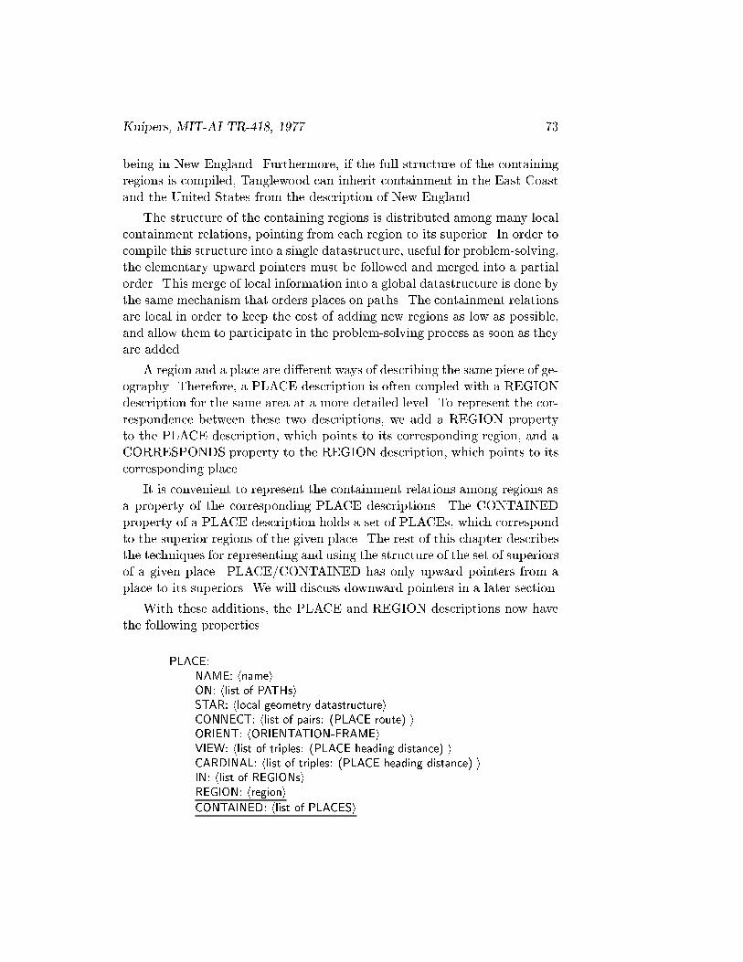
Kuipers, MIT-AI TR-418, 1977. 73
being in New England. Furthermore, if the full structure of the containingregions is compiled, Tanglewood can inherit containment in the East Coastand the United States from the description of New England.
The structure of the containing regions is distributed among many localcontainment relations, pointing from each region to its superior. In order tocompile this structure into a single datastructure, useful for problem-solving,the elementary upward pointers must be followed and merged into a partialorder. This merge of local information into a global datastructure is done bythe same mechanism that orders places on paths. The containment relationsare local in order to keep the cost of adding new regions as low as possible,and allow them to participate in the problem-solving process as soon as theyare added.
A region and a place are di�erent ways of describing the same piece of ge-ography. Therefore, a PLACE description is often coupled with a REGIONdescription for the same area at a more detailed level. To represent the cor-respondence between these two descriptions, we add a REGION propertyto the PLACE description, which points to its corresponding region, and aCORRESPONDS property to the REGION description, which points to itscorresponding place.
It is convenient to represent the containment relations among regions asa property of the corresponding PLACE descriptions. The CONTAINEDproperty of a PLACE description holds a set of PLACEs, which correspondto the superior regions of the given place. The rest of this chapter describesthe techniques for representing and using the structure of the set of superiorsof a given place. PLACE/CONTAINED has only upward pointers from aplace to its superiors. We will discuss downward pointers in a later section.
With these additions, the PLACE and REGION descriptions now havethe following properties.
PLACE:NAME: hnameiON: hlist of PATHsiSTAR: hlocal geometry datastructureiCONNECT: hlist of pairs: (PLACE route) iORIENT: hORIENTATION-FRAMEiVIEW: hlist of triples: (PLACE heading distance) iCARDINAL: hlist of triples: (PLACE heading distance) iIN: hlist of REGIONsiREGION: hregioni
CONTAINED: hlist of PLACESi
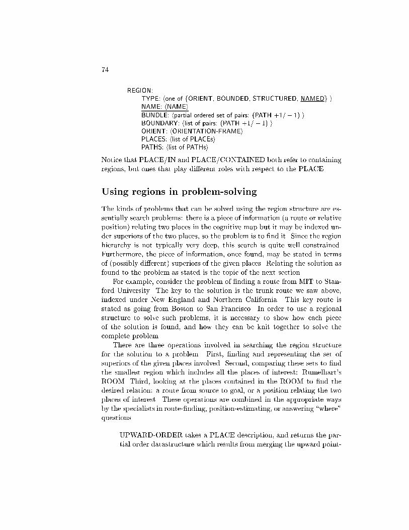
74
REGION:TYPE: hone of fORIENT, BOUNDED, STRUCTURED, NAMEDg iNAME: hNAMEi
BUNDLE: hpartial ordered set of pairs: (PATH +1=� 1) iBOUNDARY: hlist of pairs: (PATH +1=� 1) iORIENT: hORIENTATION-FRAMEiPLACES: hlist of PLACEsiPATHS: hlist of PATHsi
Notice that PLACE/IN and PLACE/CONTAINED both refer to containingregions, but ones that play di�erent roles with respect to the PLACE.
Using regions in problem-solving
The kinds of problems that can be solved using the region structure are es-sentially search problems: there is a piece of information (a route or relativeposition) relating two places in the cognitive map but it may be indexed un-der superiors of the two places, so the problem is to �nd it. Since the regionhierarchy is not typically very deep, this search is quite well constrained.Furthermore, the piece of information, once found, may be stated in termsof (possibly di�erent) superiors of the given places. Relating the solution asfound to the problem as stated is the topic of the next section.
For example, consider the problem of �nding a route from MIT to Stan-ford University. The key to the solution is the trunk route we saw above,indexed under New England and Northern California. This key route isstated as going from Boston to San Francisco. In order to use a regionalstructure to solve such problems, it is necessary to show how each pieceof the solution is found, and how they can be knit together to solve thecomplete problem.
There are three operations involved in searching the region structurefor the solution to a problem. First, �nding and representing the set ofsuperiors of the given places involved. Second, comparing these sets to �ndthe smallest region which includes all the places of interest: Rumelhart'sROOM. Third, looking at the places contained in the ROOM to �nd thedesired relation: a route from source to goal, or a position relating the twoplaces of interest. These operations are combined in the appropriate waysby the specialists in route-�nding, position-estimating, or answering \where"questions.
UPWARD-ORDER takes a PLACE description, and returns the par-tial order datastructure which results from merging the upward point-

Kuipers, MIT-AI TR-418, 1977. 75
ers in the CONTAINED property at the given PLACE and thosepointed to.
SHARED-REGIONS takes two sequences of nested PLACEs, and re-turns three values: the smallest common PLACE and the two longestdisjoint sequences of nested PLACEs.
RELATED-REGIONS takes two disjoint sequences of nested PLACEsand a property-name, and looks for a relation indexed under thatproperty-name and a PLACE in each sequence. If several such rela-tions exist, it returns the relation associated with the smallest pair ofPLACEs.
Note that although UPWARD-ORDER returns a partial order of superi-ors of the given PLACE, the other two operations take only sequences. Thesequence used by the latter two operations is the longest totally orderedsubset of the partial order produced by UPWARD-ORDER. Not examiningthe other regions in the partial order can result in two kinds of errors. First,SHARED-REGIONS may select as the smallest common PLACE one whichis larger than necessary. Second, RELATED-REGIONS may miss a relationwhich is present because it was indexed under a PLACE that was discardedfrom its partial order.
To observe these operations in action, let us consider the following nestedregion structure.
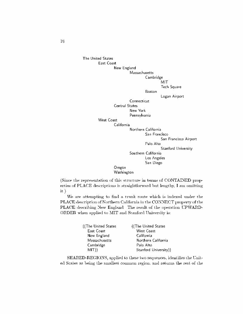
76
The United StatesEast Coast
New EnglandMassachusetts
CambridgeMITTech Square
BostonLogan Airport
ConnecticutCentral States
New YorkPennsylvania
West CoastCalifornia
Northern CaliforniaSan Francisco
San Francisco AirportPalo Alto
Stanford UniversitySouthern California
Los AngelesSan Diego
OregonWashington
(Since the representation of this structure in terms of CONTAINED prop-erties of PLACE descriptions is straightforward but lengthy, I am omittingit.)
We are attempting to �nd a trunk route which is indexed under thePLACE description of Northern California in the CONNECT property of thePLACE describing New England. The result of the operation UPWARD-ORDER when applied to MIT and Stanford University is:
((The United States ((The United StatesEast Coast West CoastNew England CaliforniaMassachusetts Northern CaliforniaCambridge Palo AltoMIT)) Stanford University))
SHARED-REGIONS, applied to these two sequences, identi�es the Unit-ed States as being the smallest common region, and returns the rest of the
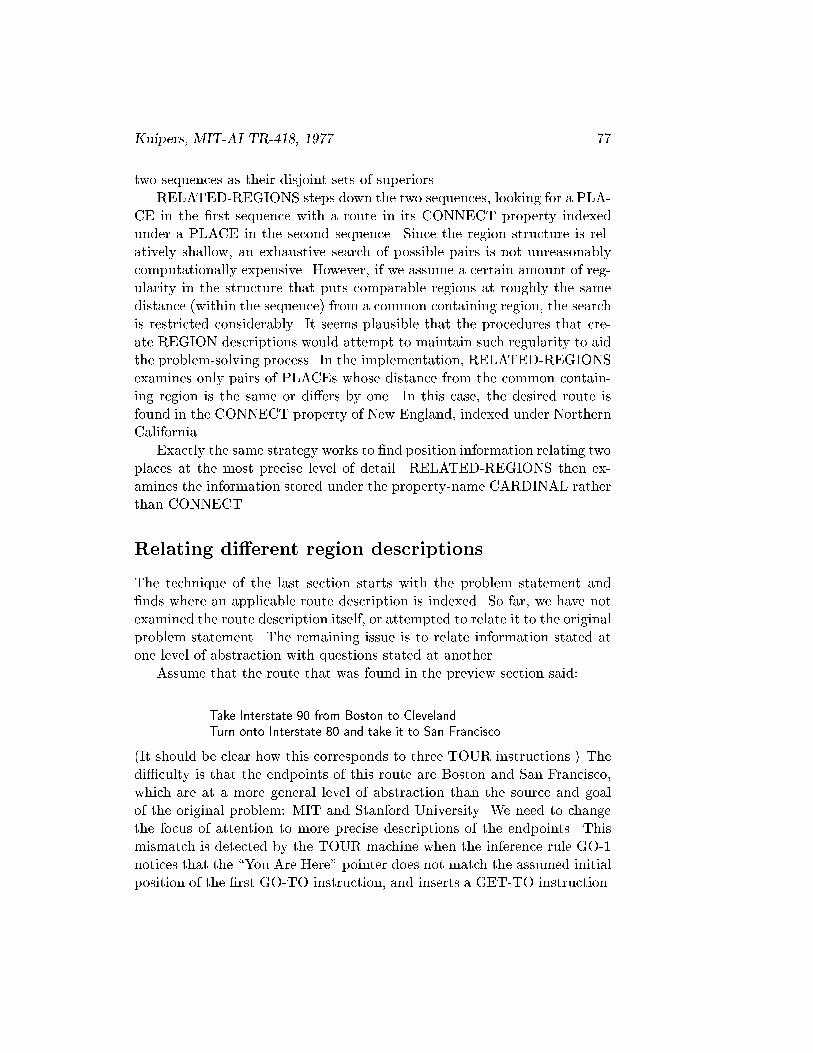
Kuipers, MIT-AI TR-418, 1977. 77
two sequences as their disjoint sets of superiors.
RELATED-REGIONS steps down the two sequences, looking for a PLA-CE in the �rst sequence with a route in its CONNECT property indexedunder a PLACE in the second sequence. Since the region structure is rel-atively shallow, an exhaustive search of possible pairs is not unreasonablycomputationally expensive. However, if we assume a certain amount of reg-ularity in the structure that puts comparable regions at roughly the samedistance (within the sequence) from a common containing region, the searchis restricted considerably. It seems plausible that the procedures that cre-ate REGION descriptions would attempt to maintain such regularity to aidthe problem-solving process. In the implementation, RELATED-REGIONSexamines only pairs of PLACEs whose distance from the common contain-ing region is the same or di�ers by one. In this case, the desired route isfound in the CONNECT property of New England, indexed under NorthernCalifornia.
Exactly the same strategy works to �nd position information relating twoplaces at the most precise level of detail. RELATED-REGIONS then ex-amines the information stored under the property-name CARDINAL ratherthan CONNECT.
Relating di�erent region descriptions
The technique of the last section starts with the problem statement and�nds where an applicable route description is indexed. So far, we have notexamined the route description itself, or attempted to relate it to the originalproblem statement. The remaining issue is to relate information stated atone level of abstraction with questions stated at another.
Assume that the route that was found in the preview section said:
Take Interstate 90 from Boston to Cleveland.Turn onto Interstate 80 and take it to San Francisco.
(It should be clear how this corresponds to three TOUR instructions.) Thedi�culty is that the endpoints of this route are Boston and San Francisco,which are at a more general level of abstraction than the source and goalof the original problem: MIT and Stanford University. We need to changethe focus of attention to more precise descriptions of the endpoints. Thismismatch is detected by the TOUR machine when the inference rule GO-1notices that the \You Are Here" pointer does not match the assumed initialposition of the �rst GO-TO instruction, and inserts a GET-TO instruction.

78
The very nature of abstraction makes this di�cult, of course: an ab-stract place represents many speci�c ones. However, we seldom need amore precise description of position unless we are planning a route, in whichcase the current position should be more fully speci�ed. The cognitive mapcontains certain correspondences between an abstract (PLACE PATH DI-RECTION) description, and a more speci�c one. For example, althoughbeing in Cambridge does not correspond to being at any particular intersec-tion in Cambridge, being in Cambridge on the Mass Pike corresponds to aparticular heading at the intersection of Storrow Drive and the River StreetBridge (in Allston!).
Such a downward mapping of position descriptions may not exist for allpossible abstract position descriptions. They are created by the processeswhich build the region descriptions. A more detailed theory of the discoveryof such correspondences must wait for further research.
The correspondence is represented by the DOWNWARD property of thehigher REGION description, which contains a list of 6-tuples. Each 6-tuplerepresents the correspondence between a higher (PLACE PATH DIREC-TION) triple and a lower one.
REGION:TYPE: hone of fORIENT, BOUNDED, STRUCTURED, NAMEDg iNAME: hNAMEiDOWNWARD: hlist of 6-tuples: (HPLACE HPATH HDIR LPLACE LPATH LDIR) i
BUNDLE: hpartial ordered set of pairs: (PATH +1=� 1) iBOUNDARY: hlist of pairs: (PATH +1=� 1) iORIENT: hORIENTATION-FRAMEiPLACES: hlist of PLACEsiPATHS: hlist of PATHsi
When a change has been selected in the focus of attention between dif-ferent descriptions of the same place, it is communicated to the TOUR ma-chine through the UP and DOWN instructions. These instructions changethe \You Are Here" pointer without corresponding to any physical travelfrom one place to another. They have the following format:
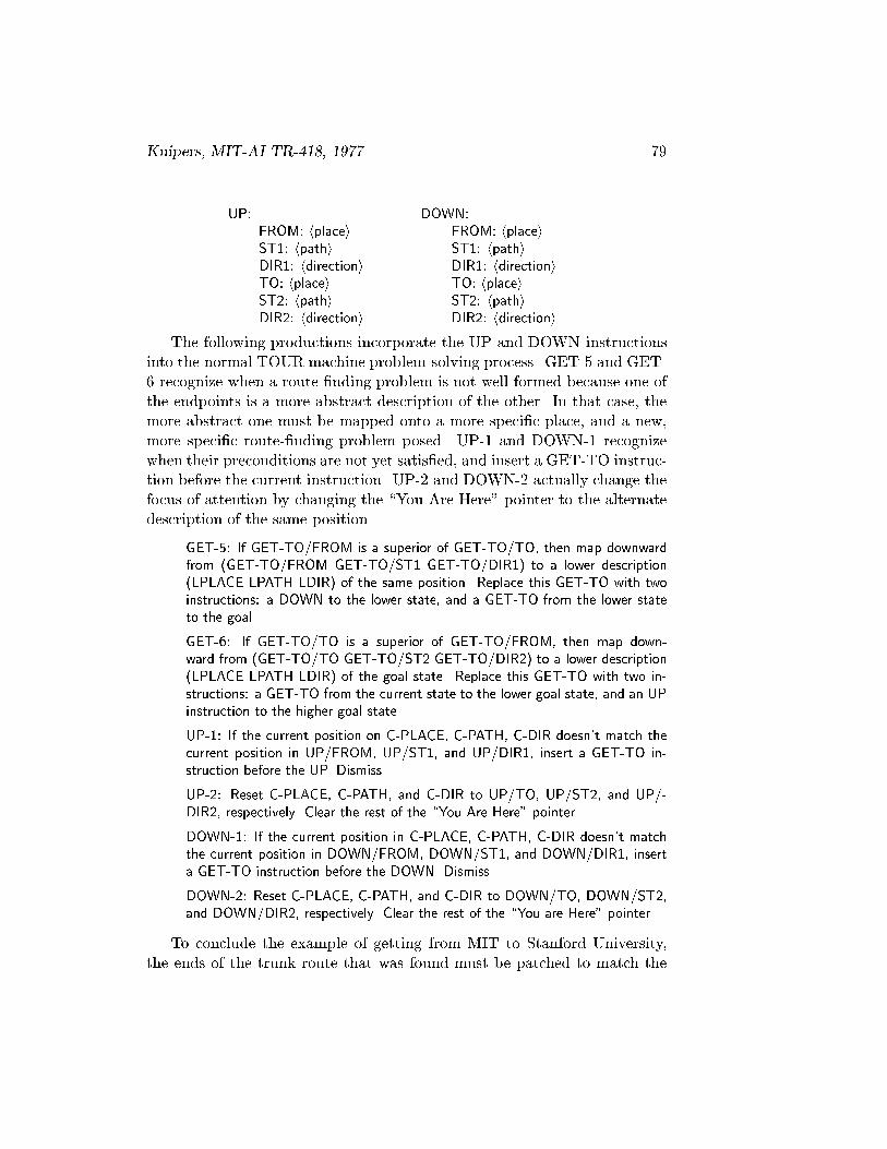
Kuipers, MIT-AI TR-418, 1977. 79
UP: DOWN:FROM: hplacei FROM: hplaceiST1: hpathi ST1: hpathiDIR1: hdirectioni DIR1: hdirectioniTO: hplacei TO: hplaceiST2: hpathi ST2: hpathiDIR2: hdirectioni DIR2: hdirectioni
The following productions incorporate the UP and DOWN instructionsinto the normal TOUR machine problem-solving process. GET-5 and GET-6 recognize when a route-�nding problem is not well-formed because one ofthe endpoints is a more abstract description of the other. In that case, themore abstract one must be mapped onto a more speci�c place, and a new,more speci�c route-�nding problem posed. UP-1 and DOWN-1 recognizewhen their preconditions are not yet satis�ed, and insert a GET-TO instruc-tion before the current instruction. UP-2 and DOWN-2 actually change thefocus of attention by changing the \You Are Here" pointer to the alternatedescription of the same position.
GET-5: If GET-TO/FROM is a superior of GET-TO/TO, then map downwardfrom (GET-TO/FROM GET-TO/ST1 GET-TO/DIR1) to a lower description(LPLACE LPATH LDIR) of the same position. Replace this GET-TO with twoinstructions: a DOWN to the lower state, and a GET-TO from the lower stateto the goal.
GET-6: If GET-TO/TO is a superior of GET-TO/FROM, then map down-ward from (GET-TO/TO GET-TO/ST2 GET-TO/DIR2) to a lower description(LPLACE LPATH LDIR) of the goal state. Replace this GET-TO with two in-structions: a GET-TO from the current state to the lower goal state, and an UPinstruction to the higher goal state.
UP-1: If the current position on C-PLACE, C-PATH, C-DIR doesn't match thecurrent position in UP/FROM, UP/ST1, and UP/DIR1, insert a GET-TO in-struction before the UP. Dismiss.
UP-2: Reset C-PLACE, C-PATH, and C-DIR to UP/TO, UP/ST2, and UP/-DIR2, respectively. Clear the rest of the \You Are Here" pointer.
DOWN-1: If the current position in C-PLACE, C-PATH, C-DIR doesn't matchthe current position in DOWN/FROM, DOWN/ST1, and DOWN/DIR1, inserta GET-TO instruction before the DOWN. Dismiss.
DOWN-2: Reset C-PLACE, C-PATH, and C-DIR to DOWN/TO, DOWN/ST2,and DOWN/DIR2, respectively. Clear the rest of the \You are Here" pointer.
To conclude the example of getting from MIT to Stanford University,the ends of the trunk route that was found must be patched to match the
80
more speci�c starting places of the problem. MIT is recognized as being amore speci�c description than (Boston I-90 nil), which is the initial state ofthe trunk route, so the Boston location is mapped to a speci�c intersection:the Mass Pike entrance on Storrow Drive in Allston. The connecting routecan now be found easily. Note that recognizing that MIT is a more speci�cplace description than Boston requires the additional information discussedin the following section.
Getting from (San-Francisco I-80 nil) to Stanford University is a similarproblem: the endpoint of the trunk route is mapped to a more speci�clocation which is connected by the Bayshore Expressway to Palo Alto. PaloAlto on the Bayshore Expressway can in turn be mapped to a more speci�clocation that is connected with Stanford University, completing the route.
Notice that the \turn" from I-90 to I-80 at Cleveland has been left inthe more abstract form. If it must be speci�ed in more detail, the twoabstract positions (Cleveland I-90 nil) and (Cleveland I-80 nil) can be mappeddownward to more speci�c place descriptions, which may be a signi�cantdistance apart. Thus, what appears to be a simple turn at one level maybecome a substantial route upon closer examination.
Generic constraints on containment
A region's �rst de�ning characteristic is usually that it contains some par-ticular place. The process of elaborating its description consists of addingcontainment relations with other regions. For example, if I am told thatmy current position is \in Tech Square," and this is my �rst acquaintancewith Tech Square, then I would like to relate it to Massachusetts, Cam-bridge, MIT, this building, my o�ce, and other regions that also containmy current position. If I know that Tech Square is a building complex,however, then I can conclude that it is contained in Cambridge and thatmy current building is contained in it. Since both MIT and Tech Squareare building complexes, I can't conclude anything about their relationship.Since Boston is a city while MIT is a building-complex, it can be seen to beat a more abstract level of description in the previous example, and call forthe downward mapping.
Je�ery (1977) suggests that this inference can be represented by a generichierarchy of region-types which can add constraints to the containmentstructure. This generic type-hierarchy and the rules for using it are:

Kuipers, MIT-AI TR-418, 1977. 81
continent i country i state i city i building-complex i building i room
Two regions of di�erent generic types cannot overlap without strict con-tainment.
The containment relations between regions of di�erent generic types can-not contradict the type-hierarchy.
The type-hierarchy �lls many of the functions of a \scale" property fora region, and thus allows knowledge of a region's generic type to functionas partial knowledge of its size.
Answering questions about \near" and \far"
We can use the structure-searching operators de�ned above to implementRumelhart's room theory question-answering with context-dependent usageof \near" and \far". The process of �nding the distance between two placesinvolves identifying the smallest common containing region: Rumelhart'sROOM. If the diameter of the region is known, then the distance can bedeclared to be \near" or \far" with respect to the size of the ROOM. Thediameter of a region is stored in the REGION description's SCALE prop-erty. fNote Quantitiesg In the current implementation, this property isacquired by direct telling, rather than being inferred from internal distanceinformation.
REGION:TYPE: hone of (ORIENT, BOUNDED, STRUCTURED, NAMED) iNAME: hNAMEiGENERIC-TYPE: hone of (CONTINENT, COUNTRY, STATE, . . . ) i
SCALE: hintegeri
DOWNWARD: hlist of 6-tuples: (HPLACE HPATH HDIR LPLACE LPATH LDIR) iBUNDLE: hpartial ordered set of pairs: (PATH +1=� 1) iBOUNDARY: hlist of pairs: (PATH +1=� 1) iORIENT: hORIENTATION-FRAMEiPLACES: hlist of PLACEsiPATHS: hlist of PATHsi
Denofsky (1976) has made a naturalistic study of the use of terms like\near" and \far." He concludes that, when a distance is estimated withina containing interval, \near" applies to distances up to 1/8 of the interval,\far" applies to distances over half of the length of the interval, and neitherterm applies to intermediate values. In answering questions about \near"and \far", the TOUR model follows Denofsky's criterion.

82
Spatial extent and internal structure
Although generic type and scale provide a partial description of the inter-nal structure of a region, they omit much of importance. Two-dimensionalshape requires a much more complex description than a scale factor. The in-ternal structure of such a region can be divided into a number of sub-regionswithout precisely de�ned boundaries. These subregions are standard for dif-ferent kinds of regions, are referred to with modi�ers like \East," \Central,"\in the northeast corner," and so on. The position of a place within such aregion can be partially described by assigning it to one of those subregions.It could be valuable to investigate the relation between this notion and thatof iconic mental images (Chapter 3).
This kind of internal structure permits an interaction between the rela-tive positions of pairs of places within the region and the scale of the regionas a whole. For example, if Spring�eld is 150 miles west of Boston, andMassachusetts has a diameter of about 200 miles, then it is safe to concludethat Spring�eld is in Western Massachusetts, while Boston is in EasternMassachusetts. Conversely, membership in di�erent subregions allows anestimate of relative position, and a range of typical relative distances withina region permits an estimate of the region's diameter.
Summary
Regions in the TOUR model exist primarily to provide levels of abstractionfor indexing and summarizing spatial information that applies to large setsof places. The relations among region descriptions are initially stored aslocal containment relations from a region to its superiors. These are notconstrained to �t into a strict hierarchy, for a place can refer to severalsuperiors whose containment relations are not known. When a problem isto be solved, however, the local containment pointers are gathered into apartial order. The largest sequences from two such partial orders can becompared to �nd the largest disjoint containing regions about the places ofinterest. It is then straightforward to search for a relationship at a numberof levels of detail. When such a relationship is found, it may be necessary toshift the level of detail at the endpoints in order to �ll in the gaps betweenthe general solution that was found and the speci�c question that was asked.
A generic type-hierarchy can add constraints to the structure of contain-ing regions, and acts as a partial description of the scale of a region. Thescale is used to provide the appropriate context-dependent level of detail

Kuipers, MIT-AI TR-418, 1977. 83
for answers to \where" and \near/far" questions. A substantially di�erentview of regions considers their extent and internal structure, and makes itpossible to describe sub-regions and positions within the region. The use ofregions as levels of abstraction has been completely implemented. Their usefor spatial extent and internal structure has not.

84
Chapter 6
Relations to Other Work
What has been is what will be,and what has been done is what will be done;and there is nothing new under the sun.
Is there a thing of which it is said,\See, this is new"?It has been already,in the ages before us.
There is no remembrance of former things,nor will there be any remembranceof later things yet to happenamong those who come after.
[Ecclesiastes 1: 9-11.]
The cognitive map, or mental image of space, has been of interest topsychologists since the work of Trowbridge (1913) on \imaginary maps."Research since then has indicated that the mental image of space does nothave the characteristics of a pictorial image, but can be decomposed intoa number of di�erent symbolic elements. This research on the cognitivemap has been surveyed by Lynch (1960), Downs and Stea (1973), Siegeland White (1975), and Moore and Golledge (1976). Arti�cial intelligenceresearch, meanwhile, has focussed on ways of representing di�erent kinds ofknowledge as symbolic descriptions. This chapter reviews the work in arti-�cial intelligence which has led to the representations in the TOUR model,and the work in environmental psychology which has outlined the kind ofknowledge to be incorporated.
85

86
Symbolic descriptions
The �eld of arti�cial intelligence is based on the assumption that knowledgeconsists of symbolic descriptions and that intelligence consists of proceduresfor manipulating such descriptions. Over the past two decades techniqueshave been developed for decomposing the knowledge involved in certain ac-tivities that require intelligence, determining the functional characteristicsof each kind of knowledge, and devising symbolic representations and mech-anisms to perform those functions.
The representation of knowledge as descriptions made up of property-value pairs was �rst investigated by Raphael (1968) in his program SIR(\Semantic Information Retrieval"). Raphael showed how such descriptionscould represent facts about class membership, class inclusion and part-ofrelationships, and how inferences could be made by examining and modify-ing the relationships among the descriptions. Evans (1968) used a similarrepresentation to solve geometric analogy problems, demonstrating that theproperty-value representation is applicable to domains that are not obvi-ously propositional. Quillian (1968) developed the \spreading activationnetwork search" which permitted unanticipated relationships to be foundbetween two descriptions. Winston (1975) showed how a system based onsymbolic descriptions could learn from short sequences of carefully chosenexamples. The result of all this research is a body of techniques for repre-senting knowledge as descriptions composed of property-value pairs, and forperforming inferences on collections of these descriptions.
Complementing the research on representing descriptions, Hewitt (1971)investigated the procedural embedding of knowledge in inference rules. Hedistinguished between two kinds of inference rules: antecedent rules, whichdraw conclusions from a given antecedent, and consequent rules, which pro-pose potential subgoals for a desired consequent. Most of the inferences inthe TOUR model are antecedent rules, which operate to draw conclusionsfrom newly provided information.
Subsequent work by Hewitt and his students [Hewitt and Smith, 1974;Greif, 1975] reexamined the distinction between procedure and datastruc-ture, and proposed to describe computations in terms of \actors": entitieswith prescribed behavior in response to messages. Parts of this notion havebeen incorporated into the TOUR model by making the descriptions intoactive datastructures (see Appendix C). Procedures associated with a de-scription, and activated by its access functions, can perform inferences whichdepend only on information locally accessible from that description.
While the computational properties of the active descriptions are in-

Kuipers, MIT-AI TR-418, 1977. 87
uenced by these developments, their semantic properties are inspired byMinsky's (1975) concept of \frames." A frame is a rich description of astereotyped class of situations which can be selected and instantiated to de-scribe a particular instance of that situation. It provides a pre-establishedset of terms for stating the description, along with defaults, constraints,and relationships among the di�erent parts of the description. A frame canalso have procedural aspects which specify how its instantiation should becarried out or how to handle certain anomalous observations. The idea offrames contrasts with the position that knowledge is primarily organizedinto assertions which are to be compared with each other individually. Thedescriptions in the TOUR model are \frames" in this sense. They providea �xed set of terms in which each geographical feature is to be described.Access functions associated with each type of description can perform localinferences based on the information directly accessible from that description.
Rule-based systems
Much of the knowledge in the TOUR model is procedurally embedded inthe inference rules. These rules are composed of tests and actions, wherethe tests are applied to information that is accessible from a small workingmemory. This kind of structure is modelled after the \production systems"of Newell and Simon (1972). A production system consists of a large long-term memory, a small short-term or working memory, and a collection ofinference rules (productions) which can examine the contents of workingmemory. One major advantage of a production system is that proceduralknowledge is represented in a modular way, requiring that interactions be-tween productions must take place through the working memory, so newproductions can be added without seriously disturbing the others. Thismeans that expertise can potentially be acquired by the incremental addi-tion of more and more expert productions, rather than requiring a monolithicprogram to be rewritten when new techniques are learned. Baylor (1971)and Moran (1973) examined how production systems could model humanvisual imagery. Howe and Young (1976) discuss how a production systemcan model individual variation in task performance by varying the collectionof productions that make up the set of inference rules.
The working memory in the TOUR model consists of the \You AreHere" pointer, which describes the current position, and the current andimmediately preceding route instructions. An inference rule in the TOURmachine can examine the properties of the descriptions that are directly
88
accessible from the working memory. Although this restricts the extent ofany search into the long-term memory, an inference rule may perform asubstantial computation to determine its applicability, rather than simplymatching a pattern. Essentially the working memory acts as a \focus ofattention" for the inference rules.
Partial knowledge
Little direct attention has been given in the arti�cial intelligence literatureto the states of partial knowledge supported by a representation. The clas-si�cation hierarchy, consisting of more and less general categories, can beseen as a structure for the states of partial knowledge in the recognitionprocess. The knowledge attached to each category is the set of assertionswarranted by that state of partial knowledge of identity. This position con-siders the structure of the hierarchy to follow from the recognition process,rather than from the inherent taxonomy of the objects categorized. Thisview is not widely held in the literature, with the exception of Collins, et al(1975) who use a classi�cation hierarchy as the primary kind of incompleteknowledge in their geography tutor.
Sacerdoti (1973, 1975) has exploited di�erent aspects of partial knowl-edge very fruitfully. Sacerdoti (1973) generates a hierarchy of abstractionspaces for planning by using partially speci�ed operators in the more ab-stract spaces. An operator is partially speci�ed by omitting one or morepreconditions for its applicability. The key concept in his later work [Sac-erdoti 1975] is that the partial state of a plan should be represented as apartial order rather than a total order. By representing the appropriatecollection of states of partial knowledge of the planning process, he is ableto state simple planning heuristics that are much more powerful than werepreviously possible. They act by adding constraints to the partial orderand decomposing operators until the plan becomes a sequence of executableoperations. The use of a partial order to model states of partial knowledgeof a sequence has been very important in this research.
Partial knowledge is often seen in popular descriptions of human mem-ory as the \hologram" metaphor. The optical hologram has the featurethat removing part of the hologram still allows a complete picture to be re-constructed, albeit with somewhat less resolution. This is compared to theability of human memory to withstand the destruction of large parts of thebrain without losing identi�able functions. Beyond this single characteristic,however, the metaphor must be viewed with considerable caution, since the
Kuipers, MIT-AI TR-418, 1977. 89
Fourier transform representation of an optical image as a hologram is not aserious candidate for a memory representation.
The search for adequate memory representations must focus on the ac-tual states of partial knowledge that memory exhibits, of which the classi�-cation hierarchy is a conspicuous example. The states of spatial knowledgedescribed in this research are another. The next chapter discusses how thecharacteristics of common-sense knowledge depend on the states of partialknowledge supported by the representations.
Environmental psychology
Kevin Lynch's delightful book The Image of the City [Lynch 1960] wasresponsible for the recent surge of interest in mental images of the environ-ment. One central point is that the mental image can be decomposed intosymbolic elements, and is not necessarily pictorial in nature or properties.He distinguishes between the qualities of imageability and legibility of anenvironment. Imageability concerns the sensory aspects of the environmentand how its landmarks evoke strong reactions. Legibility concerns the struc-tural aspects of the environment and how a traveler can �nd his way aroundin it. The properties that determine legibility are the ones addressed by thisresearch.
Although controversy still rages among cognitive psychologists aboutthe pictorial nature of mental imagery [Pylyshyn 1973, 1976; Kosslyn andPomerantz, 1977], primarily motivated by the striking mental rotation ex-periments of Shepard and his students [Shepard and Metzler, 1971; Cooperand Shepard, 1973; Shepard and Judd, 1976] the consensus among geogra-phers and environmental psychologists [Downs and Stea, 1973; Siegel andWhite, 1975; Moore and Golledge, 1976] is that the cognitive map of large-scale space is a symbolic description, quite unlike a graphical map, whichmakes it possible to answer spatial questions. Except for possible use of aniconic image as an inference device (Chapter 3), the two kinds of knowledge(of visual space and large-scale space) are quite disjoint.
Lynch decomposed the knowledge in the cognitive map into �ve elements:landmarks, nodes, paths, edges, and districts. Their functions and relation-ships correspond roughly with those of places, paths, and regions in theTOUR model. Lynch's concern with imageability led him to focus on thoseelements of the cognitive map that evoke a strong and distinct response.This led him to neglect the role of inconspicuous landmarks, nodes, andedges. For example, he identi�es as edges only those linear objects whose

90
boundary properties are so conspicuous that they dominate their path prop-erties. In the TOUR model, any street can act as both path and boundary,to the extent to which it orders the places on it and divides the places toeach side. Similarly, the place description in the TOUR model applies to anylocation a person has knowledge of, not just those that act as conspicuouslandmarks.
An important methodological contribution of Lynch's research is histechnique for drawing qualitative conclusions about the structure of the cog-nitive map from observations about individual variation. His basic assump-tion is that if two kinds of knowledge are present or absent independently indi�erent cognitive maps, then they have independent representations, evenif the representations cannot be speci�ed precisely. Variation in cognitivemaps can take place among di�erent individuals, within the same individualin di�erent environments, and in the same individual over time as he learnsor forgets a particular environment. This technique was used to supply theanecdotal descriptions of spatial knowledge in the preceding chapters.
Among other qualitative observations, this technique allowed Lynch toconclude that the cognitive map tends to be topologically correct, even whenit is seriously distorted metrically. He also observed that the cognitive mapof a large area would typically consist of highly structured regions, looselyconnected. Furthermore, the highly structured descriptions were built upover time from loose, topological descriptions [Appleyard 1970]. Another ob-servation about the process of learning a new environment was that novicestend to use prominant landmarks to orient themselves, whereas people fa-miliar with an area use local features of the street network.
Long before Kevin Lynch began his research, Jean Piaget and his col-leagues had been studying the development of many di�erent cognitive abil-ities in children. The scope of this chapter does not permit a detailed reviewof their work (see Hart and Moore (1973)). However, it is possible to drawa rough parallel between parts of the TOUR model and the developmentalstages proposed by Piaget and Inhelder (1948) for the concept of space. Theysubdivide spatial abilities into three sequentially developed stages: topolog-ical, projective, and euclidean. In the topological stage, a child is able tofollow routes and narrate sequences of observed landmarks. In the projectivestage, he can reproduce the scene from familiar observation points. In theeuclidean stage he can merge information from several projective views intoa consistent and reasonably accurate set of metrical relationships among theplaces observed.
In the TOUR model, the topological stage corresponds to the processof learning route descriptions and assimilating them into a street network

Kuipers, MIT-AI TR-418, 1977. 91
of paths and places (Chapter 2). The projective stage is characterized byrepresenting positions relative to orientation frames local to each observationpoint. The euclidean stage occurs when an orientation frame can be sharedamong a number of di�erent observations points, so relative positions fromdi�erent origins can be made comparable. (See chapter 3.) Much more workis necessary before this sketch can be turned into a detailed explanation ofthe extensive experiments and observations of the Piagetian school.
Considerable amounts of research has been reported since these pioneer-ing works. Downs and Stea (1973) collect a substantial range of di�erentapproaches to environmental psychology, including a number of attemptsto create a common conceptual framework. This search for a conceptualframework characterizes much of the research they survey. Siegel and White(1975) review research focussing speci�cally on large-scale spaces. They dis-cuss the philosophical underpinnings of the problem, compare the acquisi-tion of spatial knowledge in adults with the development of spatial abilitiesin children, and present a neurologically-based learning theory. Most re-cently, Moore and Golledge (1976) identify the emerging theoretical schoolsof thought on the appropriate terms for studying cognitive maps and includerepresentative papers from each.
Of these schools of thought, the information processing view presentedby Kaplan (1973, 1976) is most compatible with the TOUR model. Kaplandiscusses the importance of examining the information processing that istaking place inside a person's cognitive map, and argues that this compu-tational process can be described in terms of levels of symbolic descriptionsand their manipulations. However, he does not carry his theory much be-yond this general level. The TOUR model provides a substantially moredetailed description of the computations which make up the cognitive map.
New questions to ask
The studies reviewed above make an important contribution by identifying,describing and categorizing the knowledge that makes up a cognitive map.However, they lack an adequate technical language for stating their theo-ries in. The TOUR model attempts to provide such a technical languagewhich makes it possible to state (and sometimes answer) questions beyondthe scope of less formal descriptions. In order to state deep questions andanswers about the cognitive map, the technical language must recognize theexistence of the objects, such as processes and datastructures, which arenecessary to describe the computations involved.

92
Consider the question \How is the current position represented?" Ameaningful answer requires a theory of what is in the cognitive map, andof what roles the current position plays in the operations on it. The \Mapin the Head" theory says that the current position is represented as a pointon the map and a heading. The \Street Network" theory says that thecurrent position consists of a node and an arc. The heading and the arcare required because the current position must change in response to routeinstructions that don't specify their destination. Each of these theories isinadequate by itself because it doesn't contain a su�ciently rich collectionof datastructures for the range of knowledge in the cognitive map.
An analysis of this kind, focussing on the computational requirementsthe current position is called on to ful�ll, suggested the structure of the\You Are Here" pointer in the TOUR model. The distinction betweenone-dimensional orientation on a path and two-dimensional orientation withrespect to an orientation-frame arose from the computational requirementsof following a sequence of route instructions over a street network. Thisdistinction solves a dilemma encountered by Siegel and White (1975) whowere unable to formulate a model of navigation in a street network withoutglobal orientation. Global two-dimensional orientation, however, is usuallyacquired much later than the ability to navigate in a street network.
The \You Are Here" pointer plays a number of roles in addition to de-scribing the current position. It acts as a working memory for the inferencerules, as a context for incomplete instructions, as a source and destinationfor knowledge in the assimilation process, and as a focus of attention forstructure-building specialists. Computational constraints apply in both di-rections as these processes make demands on the \You Are Here" pointer,while it determines what they can do. An example of such a constraint isthat the focus of attention within which a structure-building specialist worksis limited to the contents of the \You Are Here" pointer and the current andprevious route instruction.
With the TOUR model, it is becoming possible to state currently unan-swered questions about the relation between mental descriptions of visualspace and large-scale space, between the cognitive map and the verbal andgraphical descriptions people give of it, and between the cognitive map andspatial metaphors. These questions could be stated, or answered, only inthe most general terms without a technically adequate description of theknowledge in the cognitive map.
Chapter 7
Conclusions
\There once were two watchmakers, named Hora and Tempus,who manufactured very �ne watches. Both of them were highlyregarded, and the phones in their workshops rang frequently|new customers were constantly calling them. However, Horaprospered, while Tempus became poorer and poorer and �nallylost his shop. What was the reason?
The watches the men made consisted of about 1,000 parts each.Tempus had so constructed his that if he had one partly assembledand had to put it down|to answer the phone, say|it immedi-ately fell to pieces and had to be reassembled from the elements.The better his customers liked his watches, the more they phonedhim and the more di�cult it became for him to �nd enough un-interrupted time to �nish a watch.
The watches that Hora made were no less complex than those ofTempus. But he had designed them so that he could put togethersubassemblies of about ten elements each. Ten of these subassem-blies, again, could be put together into a larger subassembly; anda system of ten of the latter subassemblies constituted the wholewatch. Hence, when Hora had to put down a partly assembledwatch in order to answer the phone, he lost only a small part ofhis work, and he assembled his watches in only a fraction of theman-hours it took Tempus."
[Simon, 1969, pp. 90-91.]
One pervading theme of this paper is the importance of considering thestates of partial knowledge which a representation can support. These are
93

94
the states that can be stored over a long period, as opposed to the knowledgerepresented in the transient state of a computation. The transition betweentwo states of a knowledge representation requires two kinds of resources: theinformation which is prerequisite for that transition and the computationtime required to perform it. A representation which permits more statesof partial knowledge will make smaller demands on those two resources inorder to make a permanent change in what is represented.
Consider a representation for knowledge of a sequence which can rep-resent only sequences. The information requirements for a transition fromone state of the representation to another are quite high, because a new el-ement must be related to every other element before it can be added at all.Furthermore, the costs are associated with merging newly acquired informa-tion into the representation, rather than with retrieval, so if computationalor information resources are lacking at that time, new information is lostforever.
Compare this with a partial order representation for partial knowledgeof a sequence. Any fragment of order knowledge can be incorporated intothe representation, so the information demands are as small as possible.Furthermore, signi�cant amounts of computational resources are expendedonly on retrieving information from the partial order and on maintainingthe datastructure in an e�cient format. Disaster does not result from thefailure of either task: the worst consequence of interruption is that certainpairs of places might be seen as lacking an order relation when in fact the in-formation is present. When resources are available again, no knowledge hasbeen lost, and performance is restored to an optimal level. An extra com-putational cost is paid when order information is retrieved in order to givethe representation vastly more expressive power, and to make it relativelyinsensitive to resource limitations.
This example illustrates how a rich collection of states of partial knowl-edge allows a representation to satisfy the \principle of graceful degrada-tion" proposed by Norman and Bobrow (1975). This principle states thatwhen an intelligent process is given insu�cient resources, there should be asmooth degradation of task performance rather than a calamitous failure.Bobrow and Norman also discuss the di�erent implications of limitations ininformation and computational resources.
A �rst implication of this principle is that assimilation of new informationshould be very easy, even at the expense of retrieval or problem-solving,because it is more calamitous to lose a piece of information entirely thanto fail to solve a particular problem. The entire assimilation process maybe long and expensive, but it should have many states of partial knowledge

Kuipers, MIT-AI TR-418, 1977. 95
so that small amounts of new information can be incorporated with smallamounts of computation. A representation which is lacking in states ofpartial knowledge can make learning too expensive to be possible.
A second implication is that it is better to assimilate new information(perhaps through a large number of intermediate states) into a rich andcomplex representation which simpli�es problem-solving than to rely on anexpensive search when a problem is presented. This is because the stateof a search process is very transient and is therefore very vulnerable tointerruptions or resource limitations. On the other hand, resources can beused to good e�ect in assimilation whenever they are available.
A rich and complex representation can be structured so that solutionsto the problems that are normally expected to arise are very easily foundwith a minimum of search, once the environment has been described. Thisdescription, ideally, can be produced by a collection of simple inferencerules, each requiring few resources, which elaborate the description whenthe information and computational resources are available.
The TOUR model has been designed in accordance with these principlesand has shown, I believe, how such representations support the exibility,power, and tolerance of inadequate information or processing resources thatis characteristic of common-sense knowledge.
Further development of the TOUR model
In some aspects of the TOUR model, the knowledge representations shouldbe improved, a new kind of knowledge should be incorporated, or new manip-ulation techniques should be developed. Some of these are straight-forwardextensions to the model, while others are substantial research problems intheir own right.
1. The TOUR model should include states of partial knowledge (or par-tial progress) for the problem-solving processes. These are potentiallypresent already in the GET-TO and TAKE instructions. It should bepossible to examine the result of a partially-successful problem-solvingattempt, or to compare two partial solutions to a problem to see whichshould be re�ned to a complete solution.
2. It should be possible to make inferences by examining the history ofinternal operations associated with parts of the cognitive map. Forexample, repeated confusion or errors associated with a particular ge-ographical feature may suggest that its description is incorrect and

96
leading to paradoxes. In general, the TOUR model lacks processes forchecking for inconsistencies and for debugging the cognitive map.
3. There are aws in the PATH description and the way it interactswith the PLACE and REGION descriptions. When corrected, theabstraction process should be smoother, and the kinds of partial orderswhich are permitted will be more restricted.
4. Metrical information is assumed to be accurate and precise, an as-sumption which is known to be false of people in interesting ways.In particular, a number has no states of partial knowledge about themagnitude of a quantity.
5. There are a number of properties of REGIONs that bear further in-vestigation. What role is played by regions with several boundaries,especially in relating to containing single-boundary regions? How isthe geometrical shape of a boundary represented? What kind of inter-nal structure does it have? How should a region be represented whenmore than one type is appropriate?
Related problems
There are, of course, many aspects of the enormous and complex domainof spatial knowledge which are not directly addressed by the TOUR model.Many related activities involve translating information to or from the cog-nitive map. Research into these activities would seem to require a detailedunderstanding of the representations which make up the cognitive map.
1. There are interesting linguistic conventions for describing routes andrelative positions. These apparently involve a sense of the appropriatelevel of detail required to relate what is said to the hearer's cognitivemap. This research would treat both the processes for translatinginformation from the cognitive map representation into English andthe description a speaker has of a hearer's cognitive map.
2. Map reading and map drawing are two forms of communication withthe cognitive map which use highly constrained media. Map readingexploits a correspondence between the cognitive map and convention-ally determined graphical symbols. The cognitive map permits manystates of partial knowledge, while the graphical map permits power-ful visual search and association methods. Map drawing encourages
Kuipers, MIT-AI TR-418, 1977. 97
dramatic inferences as the under-constrained cognitive map represen-tation is translated into the over-constrained graphical representation.These inferences depend on the symbolic feedback which occurs as aperson reads the map as he draws it.
3. Visual and kinesthetic space di�er from large-scale space in that in-formation is provided at a much greater rate and that the distinctionbetween local evidence and global structure is less clear, though justas important. Since the three spatial representations interact at manypoints, they must have much in common. Research into the structureof visual space has been taking place (e.g. Marr, et al.), but relativelylittle into common-sense kinesthetic space or into the interactions.
4. The \ ash of comprehension" is a dramatic subjective event where asingle new geographical fact initiates the reorganization of a substan-tial part of the cognitive map. Often this is triggered by the realizationthat two separate PLACE descriptions actually refer to the same phys-ical place. Rather than occuring in an instant, however, the \ ash"seems to take place over hours or even days.
5. Spatial metaphors play a prominent role in memory and problem-solving in non-spatial domains. One striking example is the common-sense representation of time. It seems initially plausible to describetime in terms of partial orders of events, along with a structure ofintervals linked by containment relations. Some intervals would bede�ned by boundary events, while others would be de�ned in termsof common characteristics of the contained events. Part of the partialordering would come from the ordering on associated dates, when thoseare known. Other parts would come from causal links.
Summary
This research is based on the assumption that the representation of knowl-edge in the cognitive map, and the methods by which new information is as-similated into that representation, are fundamental to understanding spatialcognition. Other aspects of spatial cognition can only be fruitfully investi-gated on the basis of a prior theory of representation. More speci�cially, amodel consisting of symbolic descriptions and computational processes is anadequate way to describe the cognitive map.
The TOUR model is presented as such a model, whose detailed struc-ture is designed to correspond to the evidence that is available about human

98
common-sense knowledge of large-space. The fundamental principle behindits design is that the states of partial knowledge supported by the repre-sentations are responsible for the desirable characteristics of common-senseknowledge. The goal that it attempts to achieve is to provide a precise de-scriptive language for spatial knowledge that will make it possible to stateand answer new and interesting questions.
Notes
fNote Diagramsg
It is clear that diagrams of the knowledge state would help an example likethis. Unfortunately, existing graphical conventions for drawing maps makeit di�cult to represent partial geographical knowledge without committingourselves to something actually false.
fNote LINGOLg
The natural language input to the TOUR model implementation is providedby a small context-free grammar parsed by LINGOL [Pratt 1973]. Its gram-mar has 86 rules, and it has a vocabulary of 123 words, to which it canadd place-names learned from the input. Semantic interpretation is accom-plished by a decision-tree, branching on the verb, the surface cases whichappear in the sentence, and the type of object �lling that case. Referentsare found by procedures called from the leaves of the semantic-interpretationtree, which attempt to match a name or noun-phrase with the appropriateenvironmental description. They create new descriptions when no preexist-ing referent can be found. Responses are generated from templates, withnames or descriptions of the relevant geographical features �lled in. A sen-tence can typically be read, parsed, interpreted, assimilated, and a responseprinted in less than a second.
fNote Look-behindg
Throughout most of the TOUR model, only the current instruction is ac-cessed by a production. GO-7, GO-l9, and TURN-15 are the only pro-ductions which violate this rule, and they only examine the immediatelypreceding instruction.
99

100
fNote Principlesg
David Marr (1975) has collected four design principles for the organizationand representations used by complex symbolic processes. These have beenexpressed in various forms in the Arti�cial Intelligence literature for a num-ber of years.
1. The principle of explicit naming: Whenever a collection of data is tobe described, discussed or manipulated as whole, it should �rst begiven a name. This forms the data into an entity in its own right,permits properties to be assigned to it, and allows other structuresand processes to refer to it.
2. The principle of modular design: Any large computation should be splitup and implemented as a collection of small sub-parts that are asnearly independent of one another as the overall task allows.
3. The principle of least commitment: One should never do somethingthat may later have to be undone.
4. The principle of graceful degradation: Whenever possible, degradingthe data should not prevent one from delivering at least some of theanswer.
fNote Quantitiesg
It is clear that the representations which people use for quantities are quitedi�erent from the integers in both accuracy and precision. The integer rep-resentation is used for lack of one with more states of partial knowledge.There are some indications, however, of the qualities which such a represen-tation should have. We must distinguish between: 1) quantities like distancewhich are unbounded, 2) quantities which occur on a bounded interval, and3) quantities like angle which are always on the same scale. A more realis-tic distance representation might have a �xed resolving ability applied to avariable base-line distance.
In the implementation of the TOUR machine, the only headings thatcan be directly read from input sentences are multiples of 45 degrees. Otherheadings can be computed by dead reckoning from these, of course. Fur-thermore, two headings will match on retrieval from the local geometry ofan intersection if they are within 20 degrees. It appears that little of thestructure of the TOUR model would be a�ected if distance were representedin a di�erent way.
Kuipers, MIT-AI TR-418, 1977. 101
fNote Shape Theoryg
The TOUR model does not include a theory to account for the shapes ofstreets. One version of such a theory would begin with simple descriptors forthe street such as CURVING-RIGHT, CURVING-LEFT, or TWISTY. Thenext level of description would estimate the cumulative amount of curvatureover a segment of the street. Here we encounter further problems withrepresenting quantity. We also encounter problems with segmenting thestreet description.
fNote Variationg
The kinds of variation supported by a system based on a collection of in-ference rules o�er an initially plausible explanation for human individualvariation. First, a given task may be performed by a number of di�erentrules that vary somewhat in the conditions of their applicability. Second,variations in ordering of a given collection of rules can result in variations inbehavior. Third, adding more rules to handle more cases generally improvesperformance, and thus may correspond to developmental learning. Fourth,di�erent rules which accomplish a given task may vary in their ability tosupport additional rules to expand their applicability.
The important consequence of these facts is that substantial amounts ofbehavioral variation can be produced by relatively minor changes to the setof rules within a �xed overall system architecture. Substantial individualvariation does not depend on fundamentally di�erent processing strategies.

102
References
Appleyard, D. 1970. Styles and methods of structuring a city. Envi-ronment and Behavior 2: 100-118.
Baylor, G. W. 1971. A treatise on the mind's eye: an empirical investi-gation of visual mental imagery. Unpublished Ph.D. thesis, Carnegie-Mellon University, Department of Psychology.
Collins, A., E. H. Warnock, N. Aiello, and M. Miller. 1975. Reasoningfrom incomplete knowledge. In D. G. Bobrow and A. Collins. (Eds.)1975. Representation and Understanding. New York: Academic Press.
Cooper, L. A., and R. N. Shepard. 1973. Chronometric studies ofthe rotation of mental images. In W. G. Chase. (Ed.) 1973. VisualInformation Processing. New York: Academic Press.
Denofsky, M. E. 1976. How near is near? MIT Arti�cial IntelligenceLaboratory Memo 344.
Downs, R. M., and D. Stea. (Eds.) 1973. Image and Environment.Chicago: Aldine Publishing Company.
Evans, T. G. 1968. A program for the solution of geometric-analogyintelligence test questions. In [Minsky, 1968].
Gladwin, T. 1970. East is a Big Bird. Cambridge: Harvard UniversityPress.
Greif, I. 1975. Semantics of communicating parallel processes. MITProject MAC Technical Report 154.
Hart, R. A., and G. T. Moore. 1973. The development of spatialcognition: a review. In [Downs and Stea 1973].
Hewitt, C. 1971. Procedural semantics. In R. Rustin. (Ed.) 1971.Natural Language Processing. New York: Algorithmics Press.
103

104
Hewitt, C., and B. Smith. 1975. Towards a programming apprentice.IEEE Transactions on Software Engineering SE-1: 26-45.
Howe, J. A. M., and R. M. Young. 1976. Progress in cognitive devel-opment. University of Edinburgh Department of Arti�cial IntelligenceResearch Report 17.
Je�ery, M. 1977. Personal communication.
Just, M. A., and P. A. Carpenter. l976. Eye �xations and cognitiveprocesses. Cognitive Psychology 8: 441-480.
Kaplan, S. 1973. Cognitive maps in perception and thought. In[Downs and Stea, 1973].
Kaplan, S. 1976. Adaptation, structure, and knowledge. In [Mooreand Golledge, 1976].
Kosslyn, S. M., and J. R. Pomerantz. 1977. Imagery, propositions, andthe form of internal representations. Cognitive Psychology 9: 52-76.
Lynch, K. 1960. The Image of the City. Cambridge: MIT Press.
Marr, D. 1975. Early processing of visual information. MIT Arti�cialIntelligence Memo 340.
Marr, D. 1976. From computational theory to psychology and neu-rophysiology { a case study from vision. MIT Arti�cial IntelligenceWorking Paper 131.
Minsky, M. 1968. Semantic Information Processing. Cambridge: MITPress.
Minsky, M. 1975. A framework for representing knowledge. In P. H.Winston. (Ed.) 1975. The Psychology of Computer Vision. NewYork: McGraw-Hill.
Moon, D. A. 1974. Maclisp Reference Manual. Cambridge: MITProject MAC.
Moore, G. T., and R. G. Golledge. (Eds.) 1976. EnvironmentalKnowing: Theories, Research, and Methods. Stroudsburg, PA: Dow-den, Hutchinson and Ross.
Kuipers, MIT-AI TR-418, 1977. 105
Moran, T. P. 1973. The symbolic imagery hypothesis: a productionsystem model. Unpublished Ph.D. thesis, Carnegie-Mellon University,Department of Computer Science.
Newell, A., and H. A. Simon. 1972. Human Problem Solving. Engle-wood Cli�s, NJ: Prentice-Hall.
Norman, D. A., and D. G. Bobrow. 1975. On data-limited andresource-limited processes. Cognitive Psychology 7: 44-64.
Quillian, M. R. 1968. Semantic memory. In [Minsky, 1968].
Papert, S. 1972. Teaching children to be mathematicians versus teach-ing about mathematics. Int. J. Math. Educ. Sci. Technol. 3: 249-262.
Piaget, J., and B. Inhelder. 1967. The Child's Conception of Space.New York: Norton. (First published in French, 1948.)
Pratt, V. 1973. A linguistics oriented language. Proceedings of theThird International Joint Conference on Arti�cial Intelligence, 1973.
Pylyshyn, Z. W. 1973. What the mind's eye tells the mind's brain: acritique of mental imagery. Psychological Bulletin 80: 1-24.
Pylyshyn, Z. W. 1976. Imagery and arti�cial intelligence. In W. Sav-age. (Ed.) 1976. Minnesota Studies in the Philosophy of Science, Vol.IX. Minneapolis: University of Minnesota Press.
Raphael, B. 1968. SIR: a computer program for semantic informationretrieval. In [Minsky 1968].
Rumelhart, D. E. 1974. The room theory. Unpublished computerlisting. La Jolla, CA: University of California, San Diego.
Sacerdoti, E. D. 1974. Planning in a hierarchy of abstraction spaces.Arti�cial Intelligence 5: 115-135.
Sacerdoti, E. D. 1975. A structure for plans and behavior. StanfordResearch Institute Arti�cial Intelligence Center Technical Note 109.
Shepard, R. N., and S. A. Judd. 1976. Perceptual illusion of rotationof three-dimensional objects. Science 191: 952-954.
Shepard, R. N., and J. Metzler. 1971. Mental rotation of three-dimensional objects. Science 171: 701-703.
106
Siegel, A. W., and S. H. White. 1975. The development of spatialrepresentations of large-scale environments. In H. W. Reese. (Ed.)1975. Advances in Child Development and Behavior, Vol. 10. NewYork: Academic Press.
Simon, H. A. 1969. The Sciences of the Arti�cial. Cambridge: MITPress.
Stevens, A. L. 1976. The role of inference and internal structure in therepresentation of spatial information. Unpublished doctoral disserta-tion. University of California at San Diego, Psychology Department.
Trowbridge, C. C. 1913. Fundamental methods of orientation andimaginary maps. Science 88: 888-897.
Winston, P. H. 1975. Learning structural descriptions from examples.In P. H. Winston. (Ed.) 1975. The Psychology of Computer Vision.New York: McGraw-Hill.

Appendix A
Descriptions of Environment, Current Position,
and Route
Descriptions of the environment
A PLACE is a description of a zero-dimensional geographical object. Itincludes the PATHs which that PLACE is on, and a local geometry de�ningthe radial headings of (PATH DIRECTION) pairs leaving the PLACE, withrespect to an arbitrary coordinate system. The description need not becomplete.
PLACE:NAME: hnameiON: hlist of PATHsiSTAR: hlocal geometry datastructureiCONNECT: hlist of pairs: (PLACE route) iORIENT: hORIENTATION-FRAMEiVIEW: hlist of triples: (PLACE heading distance) iCARDINAL: hlist of triples: (PLACE heading distance) iIN: hlist of REGIONsiREGION: hregioniCONTAINED: hlist of PLACESi
A PATH is a description of a one-dimensional geographical object. Itincludes a partial order on the set of PLACEs on that PATH. The DIREC-TION on a PATH can be +1 or �1, meaning \with" or \against" the orderon the PATH.
107
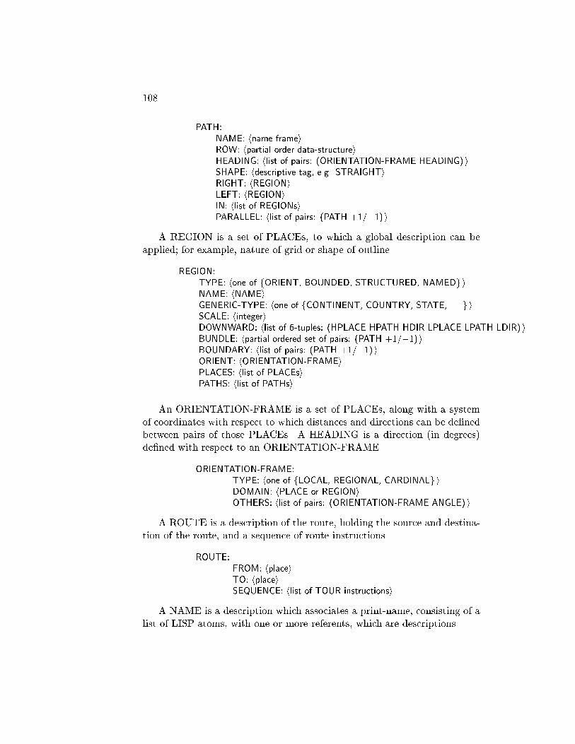
108
PATH:NAME: hname-frameiROW: hpartial order data-structureiHEADING: hlist of pairs: (ORIENTATION-FRAME HEADING) iSHAPE: hdescriptive tag, e.g. STRAIGHTiRIGHT: hREGIONiLEFT: hREGIONiIN: hlist of REGIONsiPARALLEL: hlist of pairs: (PATH +1/�1) i
A REGION is a set of PLACEs, to which a global description can beapplied; for example, nature of grid or shape of outline.
REGION:TYPE: hone of fORIENT, BOUNDED, STRUCTURED, NAMEDg iNAME: hNAMEiGENERIC-TYPE: hone of fCONTINENT, COUNTRY, STATE, . . . g iSCALE: hintegeriDOWNWARD: hlist of 6-tuples: (HPLACE HPATH HDIR LPLACE LPATH LDIR) iBUNDLE: hpartial ordered set of pairs: (PATH +1/�1) iBOUNDARY: hlist of pairs: (PATH +1/�1) iORIENT: hORIENTATION-FRAMEiPLACES: hlist of PLACEsiPATHS: hlist of PATHsi
An ORIENTATION-FRAME is a set of PLACEs, along with a systemof coordinates with respect to which distances and directions can be de�nedbetween pairs of those PLACEs. A HEADING is a direction (in degrees)de�ned with respect to an ORIENTATION-FRAME.
ORIENTATION-FRAME:TYPE: hone of fLOCAL, REGIONAL, CARDINALg iDOMAIN: hPLACE or REGIONiOTHERS: hlist of pairs: (ORIENTATION-FRAME ANGLE) i
A ROUTE is a description of the route, holding the source and destina-tion of the route, and a sequence of route instructions.
ROUTE:FROM: hplaceiTO: hplaceiSEQUENCE: hlist of TOUR instructionsi
A NAME is a description which associates a print-name, consisting of alist of LISP atoms, with one or more referents, which are descriptions.

Kuipers, MIT-AI TR-418, 1977. 109
NAME:PNAME: hlist of atomsiNAME-OF: hlist of descriptionsi
The map is a set of PLACEs, PATHs, ORIENTATION-FRAMEs, andREGIONs.
Describing the current position
The \You Are Here" pointer describes the current position of the TOURmachine in the map. It includes the current PLACE, PATH, DIRECTION,ORIENTATION-FRAME, and HEADING. Some of these may be left un-speci�ed.
YOU ARE HERE:PLACE: hplaceiPATH: hpathiDIRECTION: hdirection f+1;�1giORIENTATION-FRAME: horientation-frameiHEADING: hinteger (0; 360) iX: hintegeriY: hintegeri
The X and Y elements of the \You Are Here" pointer are for temporarystorage when a route is being followed to compute a position. They holdthe current rectangular coordinates with respect to the current orientation-frame and the starting point.
Route instructions
GO-TO instructs TOUR to move the \You Are Here" pointer from onePLACE to another on the same PATH, and speci�es the direction of travelwith respect to the PATH order. GO-TO/DIST is automatically �lled withthe \observed" distance of travel.
GO-TO:FROM: hplaceiTO: hplaceiON: hpathiDIR: hdirectioniDIST: hintegeri
TURN instructs TOUR to move the \You Are Here" pointer from one(PATH DIRECTION) pair to another at the same PLACE, and speci�es

110
the amount of the turn.
TURN:AT: hplaceiST1: hpathiDIR1: hdirectioniAMT: hnumber of degreesiST2: hpathiDIR2: hdirectioni
The GET-TO instruction formulates a problem to be solved by theproblem-solving component by specifying the state of the \You Are Here"pointer at source and destination. In case no solution can be found, theproblem-statement is left as an instruction in the route program, and TOURcontinues from its destination.
GET-TO:FROM: hplaceiST1: hpathiDIR1: hdirectioniTO: hplaceiST2: hpathiDIR2: hdirectioni
The TAKE instruction says that a particular route should be used as asub-program of the primary route, going from TAKE/FROM to TAKE/TO.
TAKE:ROUTE: hrouteiFROM: hplaceiTO: hplacei
The NOTICE instruction says that, if the traveler is at the given place,path, and direction, then the remote place can be observed at the givendistance and heading. The heading is de�ned with respect to an egocentricset of coordinates within which the heading of the observer is 0.
NOTICE:FROM: hPLACEiPATH: hPATHiDIR: hdirectioniREMOTE: hPLACEiDISTANCE: hdistance in unitsiHEADING: hegocentric heading in degreesi
When a change has been selected in the focus of attention between dif-ferent descriptions of the same place, it is communicated to the TOUR ma-chine through the UP and DOWN instructions. These instructions change

Kuipers, MIT-AI TR-418, 1977. 111
the \You Are Here" pointer without corresponding to any physical travelfrom one place to another. They have the following format:
UP: DOWN:FROM: hplacei FROM: hplaceiST1: hpathi ST1: hpathiDIR1: hdirectioni DIR1: hdirectioniTO: hplacei TO: hplaceiST2: hpathi ST2: hpathiDIR2: hdirectioni DIR2: hdirectioni
RESET clears the \You Are Here" pointer and sets it to a new PLACE,PATH, and DIRECTION, ready to execute a new program.
RESET:PLACE: hplaceiPATH: hpathiDIR: hdirectioni

112

Appendix B
Inference Rules
These inference rules are stated in English in order to eliminate inessentialdetails from the actual computer code, and to make them understandableto those not conversant with LISP. Each rule checks a number of conditionsand, if they are satis�ed, performs an action. The system is modular in thatthe model will function, although with somewhat di�erent properties, withvirtually any selection and ordering of the given rules.
Each rule is associated with an instruction type, and is active (allowedto check its conditions and run if successful) when the current instruction isof that type.
To clarify the notation: \GO-TO/FROM" refers to the FROM propertyof the GO-TO description; and \C-PLACE" refers to the PLACE elementof the \You Are Here" pointer. Similar terms have similar meanings.
GO-TO
GO-1, GO-2, and GO-3 check the current position as represented in the\You Are Here" pointer with the current position assumed by the GO-TOinstruction. Information from one can be used to �ll a gap in the other. Ifthe two descriptions disagree, an intermediate instruction may be added toget from the current position to what the instruction assumes.
GO-1: Compare GO-TO/FROM and C-PLACE. If both are empty, there is anerror. If they agree, do nothing. If only one is supplied, set the other fromits value. If they disagree, insert a GET-TO instruction as the new currentinstruction preceding this GO-TO, and restart.
GO-2: Compare GO-TO/PATH and C-PATH. If both are empty, there is an error.If they agree, do nothing. If only one is supplied, set the other from its value. Ifthey disagree, insert a TURN instruction, and restart.
113
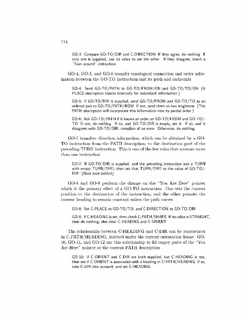
114
GO-3: Compare GO-TO/DIR and C-DIRECTION. If they agree, do nothing. Ifonly one is supplied, use its value to set the other. If they disagree, insert a\Turn around" instruction.
GO-4, GO-5, and GO-6 transfer topological connection and order infor-mation between the GO-TO instruction and its path and endpoints.
GO-4: Send GO-TO/PATH to GO-TO/FROM/ON and GO-TO/TO/ON. (APLACE description checks internally for redundant information.)
GO-5: If GO-TO/DIR is supplied, send GO-TO/FROM and GO-TO/TO as anordered pair to GO-TO/PATH/ROW. If not, send them as two singletons. (ThePATH description will incorporate this information into its partial order.)
GO-6: Ask GO-TO/PATH if it knows an order on GO-TO/FROM and GO-TO/-TO. If not, do nothing. If so, and GO-TO/DIR is empty, set it. If so, and itdisagrees with GO-TO/DIR, complain of an error. Otherwise, do nothing.
GO-7 transfers direction information, which can be obtained by a GO-TO instruction from the PATH description, to the destination part of thepreceding TURN instruction. This is one of the few rules that accesses morethan one instruction.
GO-7: If GO-TO/DIR is supplied, and the preceding instruction was a TURNwith empty TURN/DIR2, then set that TURN/DIR2 to the value of GO-TO/-DIR. fNote look-behindg
GO-8 and GO-9 perform the change on the \You Are Here" pointerwhich is the primary e�ect of a GO-TO instruction. One sets the currentposition to the destination of the instruction, and the other permits thecurrent heading to remain constant unless the path curves.
GO-8: Set C-PLACE to GO-TO/TO, and C-DIRECTION to GO-TO/DIR.
GO-9: If C-HEADING is set, then check C-PATH/SHAPE. If its value is STRAIGHT,then do nothing; else clear C-HEADING and C-ORIENT.
The relationship between C-HEADING and C-DIR can be representedin C-PATH/HEADING, indexed under the current orientation frame. GO-10, GO-11, and GO-12 use this relationship to �ll empty parts of the \YouAre Here" pointer or the current PATH description.
GO-10: If C-ORIENT and C-DIR are both supplied, but C-HEADING is not,then see if C-ORIENT is associated with a heading in C-PATH/HEADING. If so,take C-DIR into account, and set C-HEADING.

Kuipers, MIT-AI TR-418, 1977. 115
GO-11: If C-ORIENT and C-HEADING are both supplied, but C-DIR is not, thencheck C-PATH/HEADING to see if C-ORIENT is associated with a heading. Ifso, and it is close to C-HEADING or its opposite, set C-DIR accordingly. If theheadings match very poorly, ag a potential error, and go on.
GO-12: If C-HEADING and C-DIR are both supplied, then let THETA be theheading of C-PATH in the +1 direction. Put (C-ORIENT THETA) into C-PATH/HEADING.
Two orientation-frames can be compared when C-ORIENT is di�erentfrom the orientation-frame associated with C-PLACE. This situation is rec-ognized by GO-13 and analyzed by GO-14. As a result, either the relationbetween the two is stored, or one orientation-frame propagates into the ter-ritory of the other and replaces it.
GO-13: If C-ORIENT, C-HEADING, and C-DIR are all set, and C-ORIENT andC-PLACE/ORIENT are di�erent, then a collision of ORIENTATION-FRAMEshas taken place, and GO-14 must run to decide what to do.
GO-14: Obtain the current heading with respect to C-PLACE/ORIENT. If itcannot be found, do nothing. If it di�ers from C-HEADING by a multiple of 90degrees, and if C-PLACE/ORIENT is local to C-PLACE, then run GO-15 andGO-16 to merge it with C-ORIENT. Otherwise, record the relation between thereference systems in C-ORIENT/OTHERS and C-PLACE/ORIENT/OTHERS.
GO-15: If C-ORIENT/TYPE is LOCAL, then promote it to REGIONAL andadjust the appropriate pointers.
GO-16: Put C-ORIENT into C-PLACE/ORIENT. Add C-PLACE to C-ORIENT/-DOMAIN/PLACES. Change the headings in C-PLACE/STAR and C-PLACE/-VIEW to the appropriate value for C-ORIENT.
The integrated change in position accomplished by following a route canbe computed by updating C-X and C-Y by the incremental change resultingfrom the GO-TO instruction. This process occurs only when C-X and C-Yare non-NIL.
GO-17: If C-X, C-Y, C-HEADING, and GO-TO/DIST are all supplied, thentranslate C-HEADING and GO-TO/DIST into rectangular coordinates and up-date C-X and C-Y.
GO-18: If C-X and C-Y are set, but either C-HEADING or GO-TO/DIST isempty, then clear C-X and C-Y.
The relation of a place and a boundary can be computed from a TURNinstruction followed by a GO-TO.

116
GO-19: If the preceding instruction was a TURN onto GO-TO/PATH, withTURN/AMT and TURN/DIR1 speci�ed, then compute which side-region ofTURN/ST1 should contain GO-TO/TO, and put it there.
Two streets can be found to be locally parallel if they have equal oropposite headings with respect to the same orientation frame. Two streetsare examined if they fall within the focus of attention of a single GO-TOinstruction.
GO-20: Let C1 and C2 be the only cross-streets at GO-TO/FROM and GO-TO/TO, respectively. If the headings of both C1 and C2 can be found withrespect to the same ORIENTATION-FRAME, and if they are equal, put (C1 +1)into C2/PARALLEL, and (C2 +1) into C1/PARALLEL. If they are opposite, put(C1 �1) into C2/PARALLEL, and (C2 �1) into C1/PARALLEL.

Kuipers, MIT-AI TR-418, 1977. 117
TURN
TURN-1, TURN-2, and TURN-3 compare the current position in the \YouAre Here" pointer with what is assumed by the current TURN instruction.Parts of each can be used to �ll gaps in the other. If they disagree su�ciently,an extra instruction may be inserted to get from the current position to thatassumed by the TURN instruction.
TURN-1: Compare TURN/PLACE with C-PLACE. If both are empty, there isan error. If they agree, do nothing. If only one is supplied, set the other fromits value. If they disagree, insert a GET-TO instruction as the new currentinstruction preceding this TURN, and restart.
TURN-2: Compare TURN/ST1 with C-PATH. If both are empty, there is anerror. If they agree, do nothing. If only one is supplied, set the other from itsvalue. If they disagree, insert a second TURN instruction before this, commenton the oddness, and restart.
TURN-3: Compare TURN/DIR1 with C-DIRECTION. If they agree, do nothing.If only one is supplied, set the other from its value. If they disagree, there is anerror.
TURN-4 adds the topological connection between place and path as-sumed by the instruction. TURN-5, TURN-6, TURN-7, TURN-8, andTURN-9 implement the relationship between the TURN instruction andthe local geometry of the current place, transferring information to where itis needed.
TURN-4: Send TURN/ST1 and TURN/ST2 to TURN/PLACE/ON. Also, senda singleton order containing TURN/PLACE to TURN/ST1/ROW and TURN/-ST2/ROW.
TURN-5: If TURN/ST1, TURN/DIR1, TURN/ST2, TURN/DIR2, and TURN/-AMT are all supplied, then send them to TURN/PLACE/STAR, to add to thedescription of the local geometry of the PLACE. (The PLACE description incor-porates this into the appropriate data structure.)
TURN-6: If TURN/ST1, TURN/DIR1, and TURN/AMT are all supplied, butTURN/ST2 and TURN/DIR2 are not both supplied, then ask TURN/PLACE/-STAR to compute the description of the outgoing PATH from the incomingPATH and the amount of the TURN. If that is successful, use the result to setTURN/ST2 and TURN/DIR2.
TURN-7: If TURN/ST1, TURN/DIR1, TURN/ST2, and TURN/DIR2 are allsupplied, but TURN/AMT is not, then ask TURN/PLACE/STAR to computeit. If that is successful, set TURN/AMT to the result.
118
TURN-8: If TURN/ST2 remains un�lled, and TURN/PLACE/ON contains twoPATH descriptions, one of which is TURN/ST1, then set TURN/ST2 to theother.
TURN-9: If TURN/ST2 still remains un�lled, then create a new PATH descrip-tion to �ll TURN/ST2. Send it to TURN/PLACE/ON, and send a singletoncontaining TURN/PLACE to the ROW property of the new PATH. (This PATHdescription may describe the same real street as a previously created PATH de-scription, requiring some debugging later.)
TURN-10 and TURN-11 accomplish the primary e�ect of the TURNinstruction on the \You Are Here" pointer: updating the current path,direction, and heading.
TURN-10: Set C-PATH to TURN/ST2, and set C-DIRECTION to TURN/DIR2.
TURN-11: If C-HEADING and TURN/AMT are set, then update C-HEADINGby TURN/AMT; otherwise clear C-HEADING and C-ORIENT.
TURN-12, TURN-13, and TURN-14 implement the relationship betweenthe current heading and orientation frame and the local geometry of thecurrent place.
TURN-12: If C-ORIENT is empty, set it to C-PLACE/ORIENT.
TURN-13: If C-ORIENT and C-DIR are both supplied, but C-HEADING is empty,and if C-ORIENT matches C-PLACE/ORIENT, then try to set C-HEADING tothe heading associated with (C-PLACE C-DIR) in C-PLACE/STAR.
TURN-14: IF C-HEADING and C-DIR are both supplied, and if C-ORIENT isthe same as C-PLACE/ORIENT, then put (C-HEADING C-PATH C-DIR) intoC-PLACE/STAR.
The relationship between a place and a boundary can be computed froma GO-TO instruction followed by a TURN.
TURN-15: If the previous instruction was a GO-TO to TURN/AT, and TURN/-AMT and TURN/DIR2 are both speci�ed, then compute which side-region ofTURN/ST2 should contain GO-TO/FROM, and put it there.
Kuipers, MIT-AI TR-418, 1977. 119
NOTICE
The NOTICE instruction simulates an observation of a remote landmark.NOTICE-1 checks that the preconditions of the instruction are satis�ed.NOTICE-2 adds a description of the observation to the current PLACEdescription. NOTICE-3 can use the observation to determine the currentheading. NOTICE-4 can use the observation to compute the relationshipbetween two orientation frames.
NOTICE-1: Check that NOTICE/PLACE, NOTICE/PATH, and NOTICE/DIRmatch C-PLACE, C-PATH, and C-DIR. It not, complain and dismiss.
NOTICE-2: If C-ORIENT and C-HEADING are supplied, and if C-ORIENTmatches C-PLACE/ORIENT, then look up the position of NOTICE/REMOTEin C-PLACE/VIEW. If none is there, add it from the NOTICE instruction, com-pensating for egocentric coordinates by using C-HEADING. If one is there, butfails to match the NOTICE instruction, then complain. Otherwise, do nothing.
NOTICE-3: If C-ORIENT is supplied and matches C-PLACE/ORIENT, but C-HEADING is not supplied, and if C-PLACE/VIEW has a position for NOTICE/-REMOTE, then use this information to set C-HEADING.
NOTICE-4: If C-ORIENT and C-HEADING are both supplied, and there is aposition for NOTICE/REMOTE in C-PLACE/VIEW, but C-ORIENT does notmatch C-PLACE/ORIENT, then the relation between the two orientation-framescan be computed and put into C-ORIENT/OTHERS and C-PLACE/ORIENT/-OTHERS.
120
TAKE
The TAKE instruction refers to an embedded route, which is executed bythe TOUR machine in a recursive call in TAKE-5. The other rules checkfor strange conditions: TAKE-1 inserts a GET-TO if a gap exists; TAKE-3 checks for correct formats; and TAKE-2 and TAKE-4 replace the takeinstruction with its referent if the embedded route is only one instructionlong.
TAKE-1: If TAKE/from is not equal to C-PLACE, then insert a GET-TO.Restart.
TAKE-2: If TAKE/route is a single instruction (a GO-TO), then replace theTAKE with the GO-TO. Restart.
TAKE-3: If TAKE/from and TAKE/to do not agree with TAKE/route/from andTAKE/route/to, complain of a contradiction.
TAKE-4: If TAKE/route/sequence is only one instruction long, replace the TAKEwith that instruction. Restart.
TAKE-5: Else make a recursive call to TOUR to execute TAKE/route. Usethe embedded value of C-TRIP to update TAKE/route/sequence, and put theupdated TAKE instruction on the outer C-TRIP.
Kuipers, MIT-AI TR-418, 1977. 121
GET-TO
GET-TO allows problems to be posed as part of a route-description. It alsoallows route-descriptions with missing instructions to be completed. GET-1 and GET-2 detect the cases where yet another instruction is required.GET-3 calls the problem-solving component of the TOUR model to proposea solution to the problem. GET-4 handles the case where no solution isfound.
GET-1: If GET-TO/from is not equal to C-PLACE, then insert yet anotherGET-TO, and restart.
GET-2: If GET-TO/from equals GET-TO/to, then this GET-TO can be replacedwith a TURN. Restart.
GET-3: If none of the above apply, call PROPOSE-ROUTE to get a route fromGET-TO/from to GET-TO/to. If this succeeds, make a recursive call to TOURto execute the resulting route, which will go on C-TRIP as a TAKE instruction.
GET-4: If GET-3 fails, simply jump to GET-TO/to, explaining the problem tothe user, and put the GET-TO instruction on C-TRIP, hoping that the problemwill be easier some other time.
GET-5 and GET-6 implement the cases where the source and goal ofthe instruction are simply descriptions of the same place at di�erent levelsof detail. The more abstract description must be mapped down to a moreparticular one, and a di�erent GET-TO instruction provided to link the moreparticular places (Chapter 5). These rules must actually appear betweenGET-2 and GET-3 when the TOUR machine runs.
GET-5: If GET-TO/FROM is a superior of GET-TO/TO, then map downwardfrom (GET-TO/FROM GET-TO/ST1 GET-TO/DIR1) to a lower description(LPLACE LPATH LDIR) of the same position. Replace this GET-TO with twoinstructions: a DOWN to the lower state, and a GET-TO from the lower stateto the goal.
GET-6: If GET-TO/TO is a superior of GET-TO/FROM, then map down-ward from (GET-TO/TO GET-TO/ST2 GET-TO/DIR2) to a lower description(LPLACE LPATH LDIR) of the goal state. Replace this GET-TO with two in-structions: a GET-TO from the current state to the lower goal state, and an UPinstruction to the higher goal state.

122
UP and DOWN
The UP and DOWN instructions accomplish changes in the focus of atten-tion between abstract and particular descriptions of the same place. UP-1and DOWN-1 check to ensure that the preconditions are met. UP-2 andDOWN-2 change the \You Are Here" pointer to the appropriate position.
UP-1: If the current position in C-PLACE, C-PATH, C-DIR doesn't match thecurrent position in UP/FROM, UP/ST1, and UP/DIR1, insert a GET-TO in-struction before the UP. Dismiss.
UP-2: Reset C-PLACE, C-PATH, and C-DIR to UP/TO, UP/ST2, and UP/-DIR2, respectively. Clear the rest of the \You Are Here" pointer.
DOWN-1: If the current position in C-PLACE, C-PATH, C-DIR doesn't matchthe current position in DOWN/FROM, DOWN/ST1, and DOWN/DIR1, inserta GET-TO instruction before the DOWN. Dismiss.
DOWN-2: Reset C-PLACE, C-PATH, and C-DIR to DOWN/TO, DOWN/ST2,and DOWN/DIR2, respectively. Clear the rest of the \You Are Here" pointer.

Appendix C
Implementing descriptions
The descriptions that the TOUR model uses to represent knowledge aboutthe environment are implemented in LISP as property-lists of generatedatoms. Access to the property-value pairs, however, is not through theLISP functions GET and PUTPROP, but through special access functionsGETSLOT and PUTSLOT.
GETSLOT and PUTSLOT act as an interface with access functionsassociated with the property-name of that type of description. Thus, theROW property of a PATH description has a PUT-function which adds anew piece of order information to the partial order datastructure held in theROW property. In cases where the appropriate access to a property is notanalogous to a GET or PUTPROP, the access function is called explicitly,rather than through GETSLOT or PUTSLOT. An example of this is WH-ORDER, the function which asks a partial-order datastructure for the orderrelation between two given objects.
Descriptions belong to classes. All of the descriptions in a given classshare the same properties and access functions (though of course the valuesof those properties are di�erent for di�erent descriptions).
Consider the particular example of PATH descriptions. A new PATHdescription, with its properties set to default values, is created by a call tothe function CONS-PATH.
123

124
PATH0:NAME: nilROW: nilHEADING: nilSHAPE: STRAIGHTRIGHT: nilLEFT: nilIN: nilPARALLEL: nilCLASS: CONS-PATH
Subsequent calls to CONS-PATH will produce PATH descriptions on theproperty-lists of the generated atoms PATH1, PATH2, and so on. Noticethat PATH/SHAPE has the initial default value of STRAIGHT until furtherinformation is provided. PATH/CLASS refers to the description of the class,where the access functions for PATH properties are to be found.
The class description has the following properties:
CONS-PATH:EXPR: hfunction for creating PATH descriptionsiGETFNS: (DEFAULT GET
RIGHT GET-SIDE-REGIONLEFT GET-SIDE-REGION)
PUTFNS: (DEFAULT PUTPROPNAME PUTNAMEROW ADD-TO-ORDERHEADING PUTLISTIN PUTLISTPARALLEL PUTLIST)
Notice that default access functions, in this case GET and PUTPROP,are provided in case nothing is speci�ed for a particular property. GET-SIDE-REGION returns the REGION description if one is in the appropriateproperty, and creates one with the proper linkages if not. PUTLIST is auseful general-purpose PUT-function which adds a new element to a list,checking �rst for duplications. We have already seen ADD-TO-ORDER asthe access function for the partial-order datastructure in the ROW prop-erty. PUTNAME simply sets up the proper back-pointers from the NAMEdescription to the thing named.
The class of PATH descriptions is created by a call to DEFRAME whichsupplies the structure of the description and the access functions.

Kuipers, MIT-AI TR-418, 1977. 125
(DEFRAME CONS-PATH ;class description
PATH ;prefix for generated atoms
(NAME NIL L ;properties and initial values
ROW NIL
HEADING NIL
SHAPE STRAIGHT
RIGHT NIL
LEFT NIL
IN NIL
PARALLEL NIL)
(GETFNS (DEFAULT GET ;access functions
RIGHT GET-SIDE-REGION
LEFT GET-SIDE-REGION
PUTFNS (DEFAULT PUTPROP
NAME PUTNAME
ROW ADD-TO-ORDER
HEADING PUTLIST
IN PUTLIST
PARALLEL PUTLIST)))
GETSLOT and PUTSLOT simply look up their property-name underGETFNS or PUTFNS on the class description to �nd the access function forthat property. The de�nition of GETSLOT is representative. It is writtenin MACLISP [Moon 1974].
(DEFUN GETSLOT (DESCRIPTION PROPERTY)
((LAMBDA (ACCESS)
(OR ACCESS (FAULT))
(FUNCALL (OR (GET ACCESS PROPERTY)
(CAR ACCESS))
DESCRIPTION
PROPERTY))
(CDR (MEMQ 'DEFAULT
(GET (GET DESCRIPTION 'CLASS) 'GETFNS)))))
DEFRAME takes the information provided by its arguments and sets upthe properties of the class description. It also substitutes particular valuesinto a template to create the function which generates new descriptions ofthat class.

126
(DEFUN DEFRAME FEXPR (ARGS)
(PUTPROP (CAR ARGS)
(SUBLIS (LIST (CONS '*IMEM (CADDR ARGS))
(CONS '*TYPE (CADR ARGS))
(CONS '*ILIST (CAR ARGS))
(CONS '*CMEM (CAR ARGS)))
'(LAMBDA ()
(PROG (SELF)
(SETQ SELF (GEN-FRAME-NAME '*TYPE))
(SETQ *ILIST (CONS SELF *ILIST))
(SET SELF SELF)
(SETPLIST SELF
(APPEND '*IMEM
'(CLASS *CMEM)
(PLIST SELF)))
(RETURN SELF))))
'EXPR)
(PUTPROP (CAR ARGS)
(CADR (MEMQ 'GETFNS (CADDDR ARGS)))
'GETFNS)
(PUTPROP (CAR ARGS)
(CADR (MEMQ 'PUTFNS (CADDDR ARGS)))
'PUTFNS)
(SETQ FRAME-LISTS (CONS (CAR ARGS) FRAME-LISTS))
(SET (CAR ARGS) NIL)
(CAR ARGS))
GEN-FRAME-NAME generates the atoms to which new property-listsare attached. FRAME-LISTS is a global variable which lists the currentclass descriptions. The value of the class-description atom is a list of itsinstances.