korogoro creek estuary management plan
TRANSCRIPT

Damon Telfer GECO Environmental
Mat Birch Birch Aquatic Ecology Services
July 2009
Korogoro Creek Estuary Management Plan
Report prepared for Kempsey Shire Council

DISCLAIMER
Whilst every care has been taken in compiling this Estuary Management Plan no assurances are given that it is free from error or omission. The authors make no expressed or implied warranty of the accuracy or fitness of the recommendations in the plan and disclaim all liability for the consequences of anything done or omitted to be done by any person in reliance upon these recommendations. The use of this plan is at the user’s risk and discretion. The authors will not be liable for any loss, damage, costs or injury including consequential, incidental, or financial loss arising out of the use of this plan. Damon Telfer GECO Environmental 5 Arcadia Lane, GRASSY HEAD NSW 2441 Email: [email protected] © Damon Telfer, July 2009. This document is copyright and cannot be reproduced in part or whole without the express permission of the author. Cover Photo: Korogoro Creek footbridge
ACKNOWLEDGEMENTS
The following people contributed to the preparation of this Report; South bank foreshore concept plan GeoLINK, Coffs Harbour, NSW Technical Input: John Schmidt , Dept. Environment and Climate Change, Kempsey, NSW Ron Kemsley, Kempsey Shire Council, NSW

CONTENTS
EXECUTIVE SUMMARY i)
PART 1 INTRODUCTION 1 The NSW Estuary Management Planning Process 1 Korogoro Creek Estuary Study Area 1 Korogoro Creek Significance and Values 3 Korogoro Creek Estuary Management Objectives 4 Funding Estuary Management Plan Strategies 6
PART 2 KOROGORO CREEK ESTUARY MANAGEMENT STRATEGIES 7
HIGH PRIORITY ACTION 1 - Management Issue 23 10 Specific risks associated with climate change and sea level rise to Korogoro Creek estuary and to Hat Head village are currently not adequately defined or addressed in Kempsey Shire Council Policies or land use planning instruments.
HIGH PRIORITY ACTION 2 - Management Issue 11 14 Damage to aquatic ecosystems and water quality after operation of the Macleay Valley Flood Mitigation Scheme.
HIGH PRIORITY ACTION 3 - Management Issue 18 18 Impacts associated with the proliferation of access points and tracks on the southern creek bank foreshore between the traffic bridge and footbridge.
HIGH PRIORITY ACTION 4 - Management Issue 3 22 Effects of climate change and sea level rise on entrance behaviour, hydrology and estuary health.
HIGH PRIORITY ACTION 5 - Management Issue 19 26 Lack of facilities for adequate vehicle access to the southern creek bank for fishing, etc. and resulting unsafe practices in relation to parking on the roadside between the traffic bridge and footbridge.
HIGH PRIORITY ACTION 6 - Management Issue 10 28 Weed invasion in native vegetation communities along the estuary banks and foreshore.
HIGH PRIORITY ACTION 7 - Management Issue 2 31 Shoaling at the entrance has at times almost closed the creek mouth.
MEDIUM PRIORITY ACTION 8 - Management Issue 16 33 Ongoing monitoring of the groundwater quality immediately below the sewerage treatment plant (STP) Effluent Disposal Site has revealed some issues warranting closer attention.
MEDIUM PRIORITY ACTION 9 - Management Issue 8 36 Damage to Coastal Saltmarsh Endangered Ecological Community on the southern creek bank foreshore.

.
MEDIUM PRIORITY ACTION 10 - Management Issue 12* 40 Low Dissolved Oxygen (DO), high nutrients levels (particularly ammonia) and elevated Chlorophyll-a levels have been recorded in the upper reaches of the estuary near the Korogoro Cut floodgates.
MEDIUM PRIORITY ACTION 11 - Management Issue 4 43 Bank erosion on creek banks between the traffic bridge and the footbridge.
MEDIUM PRIORITY ACTION 12 - Management Issue 15 46 Preliminary event-based stormwater quality testing indicates high levels of faecal coliforms are entering the estuary from the southern side of Hat Head after moderate rainfall events.
MEDIUM PRIORITY ACTION 13 - Management Issue 22 50 Swan Pool Management and the effects of Swan Pool drainage on the estuary water quality and ecology.
MEDIUM PRIORITY ACTION 14 - Management Issue 6 53 Collection of tropical fishes from the creek for aquariums.
LOW PRIORITY ACTION 15 - Management Issue 14 55 The current Water Quality (WQ) monitoring program is inadequate to determine trends in WQ over time.
LOW PRIORITY ACTION 16 - Management Issue 7# 58 Damage to oysters on the southern creek bank downstream of the footbridge and the associated hazards to swimmers.
LOW PRIORITY ACTION 17 - Management Issue 5 60 Effects of channel sedimentation including loss of pools and associated habitat and loss of recreational amenity.
LOW PRIORITY ACTION 18 - Management Issue 1 63 Difficulty with launching larger vessels has at times necessitated the removal by Council of sand in the vicinity of the boat ramp.
LOW PRIORITY ACTION 19 - Management Issue 20 65 Boat ramp design and facilities.
LOW PRIORITY ACTION 20 - Management Issue 9 67 Poor recruitment and regeneration of native vegetation on southern creek bank foreshore.
LOW PRIORITY ACTION 21 - Management Issue 21 69 Littering and dumping of rubbish and garden wastes on estuary banks and in foreshore areas.
REFERENCES 71
APPENDICIES Appendix 1 - Korogoro Creek Entrance Management Strategy Appendix 2 - Koorgoro Creek south bank foreshore management plan Appendix 3 - Suggested water quality management plan for Korogoro Creek Appendix 4 - Funding sources Appendix 5 - Coastal saltmarsh interpretive sign example
* Incorporates Management Issue 13 from the Estuary Management Study # Incorporates Management Issue 17 from the Estuary Management Study
2009 Korogoro Creek Estuary Management Plan
i.
EXECUTIVE SUMMARY
NSW Estuary Planning Process In 1992, the NSW State Government introduced an Estuary Management Policy aimed at managing the growing pressures on estuarine systems. Under the current policy the Department of Environment and Climate Change is responsible for coordinating, in cooperation with local Councils, the preparation of estuary management plans. The procedure for developing an estuary management plan follows an 8 step process: 1. Form an Estuary Management Committee 2. Identify issues and set goals 3. Assemble existing data 4. Carry out an Estuary Process Study 5. Carry out an Estuary Management Study 6. Prepare and review the Estuary Management Plan 7. Adopt and implement the Estuary Management Plan 8. Monitor and review the management process This document, the Korogoro Creek Estuary Management Plan, addresses Step 6 in the planning process.
Korogoro Creek Estuary Management Plan The Korogoro Creek Estuary Data and Processes Studies (completed in 2007) and the Korogoro Creek Estuary Management Study (completed in May 2009) have preceded the development of the Korogoro Creek Estuary Management Plan (EMP). The Korogoro Creek EMP draws heavily upon the findings of the 2009 Estuary Management Study and readers are referred to that document to obtain a more thorough understanding of the background to the development of the management objectives, key management issues, and prioritised actions and strategies within the EMP. Once reviewed and adopted, the final EMP document is expected to remain current for a 5 year planning timeframe (2009-2014) before requiring review. A summary of the more important background information is provided below.
Korogoro Creek estuary study area Korogoro Creek is a small coastal creek with no significant tributaries that runs through Hat Head, located within the Kempsey Shire Council on the mid-north coast of New South Wales. Korogoro Creek can be considered estuarine for its entire length, the upstream marker being the floodgates that separate it from a large wetland known as ‘Swan Pool’. The entrance of the creek is untrained and believed to be permanently open. The estuary is approximately 5.4km long and has a water surface area of approximately 0.2 km2. The catchment area is approximately 18 km2 which includes Swan Pool to the west, low sand hills and swamps to the south west, the village of Hat Head to the east and south, and a proportion of the headland to the south east of Hat Head. Hat Head has a resident population of approximately 350 but the population swells during the peak holiday seasons due to the areas popularity as a holiday destination. Swimming, surfing, camping,

2009 Korogoro Creek Estuary Management Plan
ii.
fishing and boating are popular recreational pursuits of residents and visitors alike. The town has been sewered since 2001 with the treated effluent piped to a dune disposal site north of the village. The estuary is a valuable asset to the local and broader community. Korogoro Creek, though one of a network of small to medium sized estuaries on the mid north coast of NSW, is unique in a number of ways. Although extensively modified by flood mitigation it represents a healthy estuary environment, with good water quality and a diversity of habitats, flora and fauna. Korogoro Creek attracts tourists to the area helping to support the town of Hat Head. Before flood mitigation works in the late 1960s the creek was approximately 3.2km long and culminated in an extensive series of swamps located behind the coastal dune fringe. The construction of drains, floodgates and levees has significantly altered the form and function of the creek. Although considered part of the Macleay River catchment it is mostly only linked to the broader catchment during periods of significant flooding when the creek is used as an ocean release for floodwaters accumulated in Swan Pool. The processes critical to the function and health of the Korogoro Creek estuary include entrance conditions and hydrology, bank stability and sedimentation, habitat diversity and biodiversity, water quality, and human use interactions. The relationships are complex with the processes displaying a degree of interdependence.
Community and stakeholder views The integration of local community views into estuary management planning is critical to the success of the planning process. In the creation of this EMP, community and stakeholder views have been sought in a number of ways throughout the planning process including; Community Meetings – three open public meetings have been held at the Hat Head SLSC to
seek input into the EMP including a commencement meeting in May 2008; presentation and review of the Estuary Management Study including the objectives, issues raised, and priorities for management in December 2008; and, presentation and review of the Draft EMP in June 2009.
Korogoro Creek Working Group – This group is a local liaison group convened as a sub-group of the Macleay Estuary Management Committee in 2006. Draft documents and materials such as the community survey and draft prioritisation of management issues and strategies have been provided to the working group for comment.
Community Surveys – A community survey was distributed to the local community via the Hat Head post office in mid 2008. The survey expanded upon a survey conducted for the Data Compilation and Process Study in 2006/2007 and asked respondents to rank a number of Values of the estuary and Threats to those values in order of priority. These priorities have been used to assist the determination of priorities for the management of key issues identified in the estuary management study. The findings of the community survey are presented in the Estuary Management Study document.
Direct comment on draft documents – The Community Survey, Draft Korogoro Creek Estuary Management Study, and Draft Korogoro Creek Estuary Management Plan have been provided directly to members of the Macleay Estuary Management Committee for review and comment. The Survey and draft studies have also been available for download via the Kempsey Shire Council website (http://www.kempsey.nsw.gov.au/estuarymanagement.htm#). Additionally, the Draft EMP was available for open public review and comment during a 28 day public exhibition period in May-June 2009.
Media releases – Media releases advising the general public of the commencement of the study and the availability of draft documents have run in local papers over the course of the study.

2009 Korogoro Creek Estuary Management Plan
iii.
Management objectives, key issues and strategies A vision for the management of the Korogoro Creek Estuary was suggested as a part of the Estuary Management Study (2009) and has been subsequently adopted for the EMP. The vision is based on the broad estuary management goals contained in the NSW Estuary Management Policy (1992) and the Healthy Rivers Commission Inquiry into Coastal Lakes (2002), but has been determined with the assistance of community consultation. The adopted vision for management is;
“To maintain the health of the Korogoro Creek estuary and where possible improve its condition in terms of its scenic beauty, natural habitats and ecosystems, whilst supporting sustainable and compatible recreational uses for the benefit of locals and visitors”
In order to achieve this vision, seventeen (17) management objectives have been identified. The management objectives have been prioritised through community and stakeholder consultation by comparing the intent of the objective with those of the broader estuary management goals. Following the definition of the management objectives, twenty-three (23) key estuary management issues were identified. The key issues were identified through community consultation (including resident and visitor surveys and feedback from the Korogoro Creek Working Group and open community meetings), direct consultations with industry and agency stakeholders, and through reference to the information and recommendations contained within the Korogoro Creek Data Compilation and Processes Study (2007). The key estuary management issues have been ranked in terms of their priority for management over the next 5 years based on a matrices that considers the potential for the issue to impact on the identified objectives for management, the timeframe over which the impacts are likely to occur, the area likely to be affected by the issue, and the community rating of the issue derived from the 2008 community survey. In two instances, two issues have been merged due to their similarity (eg. issue 12 has been incorporated into issue 13, and issue 17 has been incorporated into issue 7) and as a result the EMP expresses the ranking of issues in terms of a rank out of 21. Seven (7) high priority issues, seven (7) medium priority issues, and seven (7) low priority issues were identified. The seven highest ranked issues were;
Rank 1. Issue 23: Specific risks associated with climate change and sea level rise to Korogoro
Creek estuary and to Hat Head village are currently not adequately defined or addressed in Kempsey Shire Council Policies or land use planning instruments.
Rank 2. Issue 11: Damage to aquatic ecosystems and water quality after operation of the Macleay Valley Flood Mitigation Scheme.
Rank 3. Issue 18: Impacts associated with the proliferation of access points and tracks on the southern creek bank foreshore between the traffic bridge and footbridge.
Rank 4. Issue 3: Effects of climate change and sea level rise on entrance behaviour, hydrology and estuary health.
Rank 5. Issue 19: Lack of facilities for adequate vehicle access to the southern creek bank for fishing, etc. and resulting unsafe practices in relation to parking on the roadside between the traffic bridge and footbridge.
Rank 6. Issue 10: Weed invasion in native vegetation communities along the estuary banks and foreshore.
Rank 7. Issue 2: Shoaling at the entrance has at times almost closed the creek mouth.

2009 Korogoro Creek Estuary Management Plan
iv.
Finally, fifty-six (56) estuary management strategies have been developed to address the key issues. A tabulated list of strategies with specific actions, responsibilities, timeframes, costings and funding sources for each issue are provided in the EMP in ranked order. Five appendices are also provided to support the strategies including an entrance management strategy (Appendix 1), a south bank foreshore management plan (Appendix 2), a suggested water quality management plan (Appendix 3), a list of funding sources available for implementing estuary management actions (Appendix 4), and an example of a coastal saltmarsh interpretive sign (Appendix 5).
~ 0 ~

2009 Korogoro Creek Estuary Management Plan
1.
PART 1 INTRODUCTION
The many estuaries of NSW are of great environmental, social and economic importance. Estuaries are calculated to contribute about $400 million to the NSW economy through ecosystem services, food chain contributions and tourism and development (DWE, 2008). The Northern Rivers Region is experiencing one of the greatest population growths in Australia, with increasing demand for development and a demographic shift from predominantly rural to increasingly semi-rural and urban communities (NRCMA, 2006). Coastal shires are among the fastest developing areas in NSW with around 80% of the NSW population now living in coastal areas, including the shores of estuaries (DWE, 2008). The increase in use and population pressure is having an impact on the estuaries of NSW and their environmental, social and economic values. Climate change, habitat degradation, water quality issues, loss of amenity and access restrictions are some of the issues confronting coastal communities and their councils.
NSW Estuary Management Planning Process In 1992, the NSW State Government introduced an Estuary Management Policy aimed at managing the growing pressures on estuarine systems. Under the policy the then Department of Natural Resources (now Department of Environment and Climate Change, DECC) is responsible for coordinating, in cooperation with local Councils, the preparation of Estuary Management Plans (EMP). The procedure for developing an EMP is set out in the Estuary Management Manual (NSW Government, 1992). The current revision of the procedure follows an 8 step process; 9. Form an Estuary Management Committee 10. Identify issues and set goals 11. Assemble existing data 12. Carry out an Estuary Process Study 13. Carry out an Estuary Management Study 14. Prepare and review the Estuary Management Plan 15. Adopt and implement the Estuary Management Plan 16. Monitor and review the management process The Korogoro Creek Data and Processes Studies (Steps 3-4) were completed in 2007 with the Korogoro Creek Estuary Management Study (Step 5) completed in 2009. This document, the Korogoro Creek Estuary Management Plan addresses step 6 in the planning process. Once reviewed and adopted, the final EMP document is expected to remain current for a 5 year planning timeframe (2009-2014) before requiring review. To avoid unnecessary repetition, readers should refer to the Data and Processes Study Report (Telfer, 2007) and the Estuary Management Study (Telfer and Birch, 2009) for more information as to how the management issues and strategies dealt with in the EMP were determined.
Estuary Plan Area Korogoro Creek is a small coastal creek with no significant tributaries that runs through Hat Head, located within the Kempsey Shire Council on the mid-north coast of New South Wales. Korogoro Creek can be considered estuarine for its entire length, the upstream marker being the floodgates that separate it from a large wetland known as ‘Swan Pool’. The entrance of the creek is untrained and believed to be permanently open. The estuary is approximately 5.4km long and has a water surface area of approximately 0.2 km2. The catchment area is approximately 18 km2 which includes Swan

2009 Korogoro Creek Estuary Management Plan
2.
Pool to the west, low sand hills and swamps to the south west, the village of Hat Head to the east and south, and a proportion of the headland to the south east of Hat Head (Figure 1). The catchment area is mostly undeveloped except for the small village of Hat Head which occupies approximately 4% of the catchment. 63% of the catchment is protected in the Hat Head National Park. The catchment vegetation is predominantly swamp sclerophyll and shrubby dry forests on the low sand hills; heathland, arid and semi arid shrublands on sand and peat plains and parts of the headland; freshwater and saline wetlands in low swamp areas; and with small occurrences of littoral rainforest and wet sclerophyll forests in protected headland and back dune locations. Korogoro Creek was extensively modified by flood mitigation works in the late 1960s. Before this time the creek was approximately 3.2km long and culminated in an extensive series of swamps located behind the coastal dune fringe. The construction of drains, floodgates and levees has significantly altered the form and function of the creek. Although considered part of the Macleay River catchment it is mostly only linked to the broader catchment during periods of significant flooding when the creek is used as an ocean release for floodwaters accumulated in Swan Pool. In order to protect the village from flooding during such releases levees have been constructed along the length of the creek and a “Choke” installed to moderate flood heights in the creek. The “Choke” is a control structure which moderates flow down the channel to below the constructed levee height and diverts excess flood waters through Rowe’s Cut to the ocean (see Figure 1). Hat Head has a resident population of approximately 350 but the population swells during the peak holiday seasons due to the areas popularity as a holiday destination. Swimming, surfing, camping, fishing and boating are popular recreational pursuits of residents and visitors alike. The town has been sewered since 2001 with the treated effluent piped to a dune disposal site north of the village (see Figure 1).
Figure 1 Korogoro Creek Estuary Management Plan study area

2009 Korogoro Creek Estuary Management Plan
3.
Korogoro Creek Significance and Values The Korogoro Creek estuary is a valuable asset to the local and broader community. Korogoro Creek, though one of a network of small to medium sized estuaries on the mid north coast of NSW, is unique in a number of ways. It has been extensively modified but it represents a healthy estuary environment, with good water quality and a diversity of habitats, flora and fauna. Korogoro Creek attracts tourists to the area helping to support the town of Hat Head. It also plays a role in the Macleay Valley flood mitigation scheme.
Table 1 Summary of Korogoro Creek estuary values (Telfer and Birch, 2009)
Local and Regional Significance
• One of a network of small estuaries which are a focal point for local recreation and tourism
• Different to other local ICOLLs as it has a permanently open, untrained entrance
• Permanently open status means water quality is consistently suitable for primary contact and environmental protection
• Aquatic fauna have permanent access to oceanic water, enhancing biodiversity and ecological functioning.
Cultural Heritage Values
• Part of the traditional area of the Djaingutti (or Thungutti) group of aboriginal people.
• Local area around Hat Head was also occupied by Bilpai and Goombaingirr people
• 3 aboriginal culture sites recognised in the immediate vicinity of the estuary
• No formally recognised built heritage sites are recorded
Recreational Values • Safe swimming, particularly for young children and families
• Recreational boating including kayaks, canoes, and small motorised boats
• Recreational fishing and bait collection
• Relatively safe open water access via the boat ramp
Scenic Values • Stunning visual backdrop to the village of Hat Head
• Surrounded by vegetated hills almost wholly contained in Hat Head National Park
Water Quality Values
• Well flushed (1-2 days)
• Generally within NHMRC (2008) guidelines for primary contact recreation
• Generally within ANZECC guidelines for environmental protection
• No significant issues with faecal contamination
Ecological Values • Supports a wide variety of fauna and flora in a variety of aquatic habitats
• Has numerous areas of protected wetlands (SEPP14) and protected littoral rainforests (SEPP26)
• Has several Endangered Ecological Communities in the catchment including Coastal Saltmarsh, Littoral Rainforests, Swamp Sclerophyll Forests, Swamp Oak Forests, and Freshwater Wetlands
• Supports several threatened and endangered species including the Loggerhead turtle and Osprey.
Socio-economic Values
• Local tourist drawcard • Recreational opportunities including safe swimming, quality fishing, easy open water access.
• Part of the Macleay Valley flood mitigation scheme providing flood security for lower Macleay towns and villages
• Important nursery for fish species of both commercial and recreational interest

2009 Korogoro Creek Estuary Management Plan
4.
Korogoro Creek Estuary Management Objectives The objectives for management of the Korogoro Creek estuary were formulated as part of the Estuary Management Study (Telfer and Birch, 2009) and have been based on;
The NSW Government’s Estuary Management Policy (NSW Government, 1992); which aims to achieve the integrated, balanced, responsible and ecologically sustainable use of the State’s estuaries which form a key component of coastal catchments
The Healthy Rivers Commission Independent Inquiry into Coastal Lakes (HRC, 2002) which for systems defined as being in healthy modified condition (such as Korogoro Creek estuary) recommends that the objective of management should be to ‘rehabilitate and retain key natural processes and/or modified values and determine appropriate types and sustainable levels of human uses’
Community consultation undertaken during the Estuary Management Study which showed general agreement in the local community with the following key principles; - The estuary is an important asset to the residents of Hat Head and is a strong drawcard
for visitors to the area. - The estuary is considered by most community members to be in good overall condition - The estuary is used for a variety of passive and active recreational uses and usage needs
to be managed to avoid conflict between users, to ensure safety of users, and to maintain the health of the estuary
- There is a strong desire for the estuary to be maintained in its current healthy condition and if possible improved.
- There is a strong desire for vehicle access directly to the creek bank to be managed. This is conditional on access to the estuary being maintained.
The guiding principles of management included in the NSW Estuary Management Policy, the findings of Healthy Rivers Commission inquiry into Coastal Lakes, and the objectives identified during community consultation processes as detailed above, have been used to formulate a vision for the management of the Korogoro Creek estuary. The vision adopted for the Estuary Management Plan is;
“To maintain the health of the Korogoro Creek estuary and where possible improve its condition in terms of its scenic beauty, natural habitats and ecosystems, whilst supporting sustainable and compatible recreational uses for the benefit of locals and visitors”.
Table 2 Prioritised List of Korogoro Creek Management Objectives (2009 to 2014; Telfer and Birch, 2009).
Estuary Management Objective Priority
Minimise impacts upon estuary health resulting from bank erosion and associated sedimentation by managing activities that impact bank stability. HIGH
Protect terrestrial habitats of high ecological or conservation value (e.g. riparian vegetation, endangered ecological communities such as Coastal Saltmarsh, Freshwater Wetlands and Littoral Rainforests).
HIGH
Protect aquatic habitats of high ecological or conservation value and their associated biodiversity (e.g. Mangroves, seagrasses, endangered species, tropical fish).
HIGH
Maintain the estuary water quality within National Health and Medical Research Council guidelines (NHMRC, 2008) for recreational use year round. HIGH

2009 Korogoro Creek Estuary Management Plan
5.
Estuary Management Objective Priority
Manage access to the estuary foreshore in areas of high use to protect public safety and ensure estuarine health objectives are achieved. HIGH
Raise community awareness of estuarine processes and the sensitivities of the estuarine environment to increase the level of understanding of human usage impacts upon estuaries.
HIGH
Maintain the entrance of the creek in a condition that meets the needs of recreational users whilst protecting the ecology and overall health of the estuary. MEDIUM
Improve estuary health by implementing appropriately designed bank stabilisation and rehabilitation works in high priority areas of bank erosion. MEDIUM
Restore terrestrial habitats of high ecological or conservation value by removing threats and through targeted rehabilitation (e.g. riparian vegetation, endangered ecological communities such as Coastal Saltmarsh, Freshwater Wetlands and Littoral Rainforests).
MEDIUM
Restore aquatic habitats of high ecological or conservation value by removing threats and through targeted rehabilitation (e.g. Mangroves). MEDIUM
Reduce the impact of the operation of Macleay Valley Flood mitigation scheme through implementing actions in Swan Pool. MEDIUM
Ensure that the potential future implications of climate change and sea level rise are incorporated into reviews of Kempsey Strategic Planning framework. MEDIUM
Reduce urban stormwater pollutant loads entering Korogoro Creek LOW
Maintain the water quality of groundwater aquifers in the vicinity of Hat Head township. LOW
Implement a long-term water quality monitoring program that allows for the identification of water quality issues and trends that may affect estuary health or recreational users of the estuary.
LOW
Provide for a range of recreational opportunities compatible with the estuary’s values (eg. Low key setting, family orientated, etc.) in a way that does not impact upon those values or estuary health.
LOW
Reduce impacts associated with poor water quality entering the creek via Korogoro Cut by implementing actions to remediate Acid Sulfate Soil Issues in the Swan Pool.
LOW

2009 Korogoro Creek Estuary Management Plan
6.
Funding Estuary Management Plan Strategies and Actions The Korogoro Creek estuary is an important natural, social, and economic asset. The management strategies outlined in this Estuary Management Plan (EMP) have been formulated with the protection and improvement of the estuary for the benefit of residents, visitors, the environment and dependent economic enterprises as the primary goal. In order to achieve this goal significant resources are required, the costs of which exceed the resources of the local authorities responsible for the recommended actions. Consequently, supplementary funding to undertake the actions is generally required. There are a number of sources of funding available for the types of works suggested within the EMP. Many of these sources require the formulation of an EMP with specific, prioritised tasks to be eligible for funding. Some require available funds to be matched by the applicant on a dollar for dollar basis. Opportunities under the various programs change over time and include;
Caring for our Country grants NSW Coastal, Estuary & Floodplain Management Programs; NSW Environmental Trust grants; Maritime Infrastructure Program; NSW Recreational Fishing Trusts; Grants to Voluntary Environmental and Heritage Organisations; Raising National Water Standards Program; Country Towns Water Supply and Sewage Program; Green Corps; Northern Rivers CMA base funding; and Operational budgets of the NSW Department of Lands and Hat Head National Park, and the
Kempsey Shire Council general revenue process.
A comprehensive description of each of these funding sources is provided in Appendix 4.

2009 Korogoro Creek Estuary Management Plan
7.
PART 2 KOROGORO CREEK ESTUARY MANAGEMENT STRATEGIES
Estuary management strategies have been developed to address the key estuary management issues identified in the Korogoro Creek Estuary Management Study (Telfer and Birch, 2009). A ranked list of the issues is provided in Table 3 (see overleaf). Rankings were determined based on (see Telfer and Birch, 2009 for more detail);
The issues’ potential to impact on the identified objectives for management The timeframe over which the impacts are likely to occur The area likely to be affected by the issue, and The community rating of the issue derived from the 2008 community survey.
Tabulated strategies containing specific actions, responsibilities, timeframes, costings and funding sources for each issue are provided in the next sections of the EMP. Five appendices are also provided to support the strategies. These are;
Appendix 1 - Korogoro Creek entrance management strategy Appendix 2 - Korogoro Creek south bank foreshore management plan Appendix 3 - Suggested water quality management plan for Korogoro Creek Appendix 4 - Funding sources Appendix 5 - Coastal saltmarsh interpretive sign example

2009 Korogoro Creek Estuary Management Plan 8.
Table 3 Ranked List of Key Estuary Management Issues (Telfer & Birch, 2009)
Key Estuary Management Issue Priority Ranking (of 21)
23 Specific risks associated with climate change and sea level rise to Korogoro Creek estuary and to Hat Head village are currently not adequately defined or addressed in Kempsey Shire Council Policies or land use planning instruments. HIGH 1
11 Damage to aquatic ecosystems and water quality after operation of the Macleay Valley Flood Mitigation Scheme. HIGH 2
18 Impacts associated with the proliferation of access points and tracks on the southern creek bank foreshore between the traffic bridge and footbridge. HIGH 3
3 Effects of climate change and sea level rise on entrance behaviour, hydrology and estuary health. HIGH 4
19 Lack of facilities for adequate vehicle access to the southern creek bank for fishing, etc. and resulting unsafe practices in relation to parking on the roadside between the traffic bridge and footbridge. HIGH 5
10 Weed invasion in native vegetation communities along the estuary banks and foreshore. HIGH 6
2 Shoaling at the entrance has at times almost closed the creek mouth. HIGH 7
16 Ongoing monitoring of the groundwater quality immediately below the sewerage treatment plant (STP) Effluent Disposal Site has revealed some issues warranting closer attention. MEDIUM 8
8 Damage to Coastal Saltmarsh Endangered Ecological Community on the southern creek bank foreshore. MEDIUM 9
12 Low Dissolved Oxygen (DO), high nutrients levels (particularly ammonia) and elevated Chlorophyll-a levels have been recorded in the upper reaches of the estuary near the Korogoro Cut floodgates. MEDIUM 10
13* Elevated Chlorophyll-a levels have been recorded in the upper reaches during periodic water quality sampling. Combined with Issue 12 for treatment within the EMP. MEDIUM
4 Bank erosion on creek banks between the traffic bridge and the footbridge. MEDIUM 11
15 Preliminary event-based stormwater quality testing indicates high levels of faecal coliforms are entering the estuary from the southern side of Hat Head after moderate rainfall events. MEDIUM 12

2009 Korogoro Creek Estuary Management Plan 9.
Key Estuary Management Issue Priority Ranking (of 21)
22 Swan Pool Management and the effects of Swan Pool drainage on the estuary water quality and ecology. MEDIUM 13
6 Collection of tropical fishes from the creek for aquariums. MEDIUM 14
14 The current Water Quality (WQ) monitoring program is inadequate to determine trends in WQ over time. LOW 15
7 Damage to oysters on the southern creek bank downstream of the footbridge and the associated hazards to swimmers. LOW 16
17* Hazards to swimmers resulting from damage to oysters on the southern creek bank downstream of the footbridge. Combined with Issue 7 for treatment in the EMP. LOW
5 Effects of channel sedimentation including loss of pools and associated habitat and loss of recreational amenity. LOW 17
1 Difficulty with launching larger vessels has at times necessitated the removal by Council of sand in the vicinity of the boat ramp. LOW 18
20 Boat ramp design and facilities. LOW 19
9 Poor recruitment and regeneration of native vegetation on southern creek bank foreshore. LOW 20
21 Littering and dumping of rubbish and garden wastes on estuary banks and in foreshore areas. LOW 21
* Management Issue 13 has been incorporated into Management Issue 12 Management Issue 17 has been incorporated into Management Issue 7

2009 Korogoro Creek Estuary Management Plan 10.
MANAGEMENT ISSUE 23 Priority: HIGH Ranking: 1/21
Specific risks associated with climate change and sea level rise to Korogoro Creek estuary and to Hat Head village are currently not adequately defined or addressed in Kempsey Shire Council Policies or land use planning instruments.
Supports or is related to the following Management Issues
Management Issue 3 (p.22)
Description
A Draft Sea Level Rise Policy Statement was released by the NSW State Government in February 2009 (DECC, 2009; http://www.environment.nsw.gov .au/resources/climatechange/09125DraftSLRpolicy.pdf). The policy gives recognition to the fact that sea level rise is a gradual process that will have medium- to long-term impacts including a permanent increase in sea levels relative to current sea levels and increased coastal hazards (particularly beach erosion) and flooding risks during major storms. This will impact on coastal land and foreshore land around estuaries, bays and harbours, increasing the tidal inundation of foreshore land and structures, and reducing the ability to effectively drain low-lying coastal areas. As a part of the Draft Policy, the NSW Government has adopted a sea level rise planning benchmark. This benchmark will enable consistent consideration of sea level rise within an adaptive risk-based management approach. There is no regulatory or statutory requirement for development to comply with this benchmark, rather the benchmark’s primary purpose is to provide guidance to support consistent consideration of sea level rise impacts within applicable decision-making frameworks. This will include strategic planning and development assessment under the Environmental Planning and Assessment Act
Figure 1 Land generally under 10m elevation AHD and potentially at risk from climate change effects by 2100 (inferred from Soil Landscape Mapping, DECC, 2000).

2009 Korogoro Creek Estuary Management Plan 11.
1979 and infrastructure planning and renewal. The NSW sea level rise planning benchmark is an increase above 1990 mean sea levels of 40 cm by 2050 and 90 cm by 2100 (see http://www.environment.nsw.gov.au/resources/ climatechange/09126DraftSLRTechNote.pdf for the scientific justifications for the benchmark). The Government will periodically review this planning benchmark as updated information becomes available. The sea level rise planning benchmark can be used for purposes such as:
incorporating the projected impacts of sea level rise on predicted flood risks and coastal hazards the designing and upgrading of public assets in low-lying coastal areas where appropriate, taking into account the design life of the asset and the
projected sea level rise over this period assessing the influence of sea level rise on new development considering the impact of sea level rise on coastal and estuarine habitats, such as salt marshes, and identifying valuable habitats at most risk from sea
level rise assessing the impact of changed salinity levels in estuaries, including implications for access to fresh water.
There are currently no land use planning controls or instruments in place for addressing the predicted future impacts of climate change on the Korogoro Creek estuary or the township of Hat Head. However, it is foreseeable that changes in sea level in line with the benchmark set by the NSW Government and accompanying impacts would affect existing property and infrastructure, natural assets and ecosystems, development planning, the drainage network, retention basins, and operational strategies for flood mitigation. Potential impacts should be determined using the State Government benchmark, planned for, and mitigated against where possible. The document Climate Change Adaptation Actions for Local Government (available at http://www.climatechange.gov.au/impacts/publications/pubs/local-government.pdf) provides a range of guidelines and strategies to assist local governments to prioritise actions related to the impacts of climate change. The actions deemed most prudent in relation to Korogoro Creek estuary and its management are contained within Strategies 23.1–23.4 and are also closely related to Strategies 3.1-3.4.

2009 Korogoro Creek Estuary Management Plan 12.
Strategies applicable to Management Issue 23
Strategy Responsibility Specific Tasks Timeframe Cost Potential Funding Sources
Strategy 23.1 Obtain sufficiently accurate elevation data to enable the determination of the potential risks to lands, built infrastructure and natural assets under various sea level rise scenarios.
DECC Dept. Lands
(Land and Property Information)
KSC
Predicting potential future risks to lands, built infrastructure and natural assets requires high-resolution surface elevation mapping. High-resolution elevation data allows hydrological and inundation models to be developed based upon various climate change scenarios. Four actions are required; Ground control points should be established using Digital GPS and
high resolution satellite imagery obtained using ground controls for ortho-rectification (eg. Quickbird 4)
Hydrological modelling of estuary should be undertaken (see Strategy 3.1, p.24))
Digital GPS should be used to capture accurate elevation data for built infrastructure
Airborne laser scanning LiDAR technology should be used to capture comprehensive surface elevation data (vertical height accuracy ±0.15m) over the study area.
2-4 years. Preferably before finalising next KSC LEP as there are likely to be planning implications.
Indicative costs of Actions 1-3 for Korogoro Creek would be ~$20,000. LiDAR data for Macleay coastal subcatchment approximately $150,000.
DECC Dept. Lands
(potentially from existing programs)
Strategy 23.2 Identify areas of land within the Korogoro Creek catchment at risk from predicted changes to sea level rise and changed weather patterns and use LEP and DCP instruments to manage future development.
KSC Dept.
Planning
Subsequent to the collection of detailed surface elevation data and the production of inundation risk maps, LEP and DCP instruments should be used to prevent developments in areas that would be at risk from inundation impacts.
2-4 years. Preferably before finalising next KSC LEP as there are likely to be planning implications.
Costs incorporated into Strategy 23.1 as inundation areas will be an output of that strategy’s actions.
KSC (Planning Department)
Continued overleaf…

2009 Korogoro Creek Estuary Management Plan 13.
Strategy Responsibility Specific Tasks Timeframe Cost Potential Funding Sources
Strategy 23.3 Consider the impacts of climate change on existing assets, identify assets at risk, determine strategies for relocation, and identify lands suitable for relocation of at-risk assets and infrastructure and use LEP and DCP instruments to quarantine such land for potential use for asset and infrastructure relocation.
KSC Dept.
Planning
Subsequent to Strategies 23.1 and 23.2 above, this Action will allow for mitigation measures to be incorporated into KSC planning instruments that cover the most likely impacts of climate change scenarios.
2-4 years. Preferably before finalising next KSC LEP as there are likely to be planning implications.
Costs low as will be an output of Strategies 23.1 and 23.2 above.
KSC (Planning Department)
Strategy 23.4 Model the impacts of higher sea levels on the operation of the Macleay Valley Flood Mitigation Scheme and associated infrastructure and develop strategies for adaptation.
KSC Dept.
Commerce DECC Flood
Program Flood
Management Authority
The operation of the Korogoro Cut and other associated flood mitigation infrastructure would need to be modelled as a part of a wider investigation into the operation of the entire Macleay Valley Flood Mitigation Scheme under the various climate change scenarios.
5-10 years Estimated at $350,000 (including $150,000 for LIDAR dataset covering the floodplain and $200,000 for accurate floodplain modelling)
DECC KSC Dept. Lands
(Land and Property Information branch)

2009 Korogoro Creek Estuary Management Plan 14.
MANAGEMENT ISSUE 11 Priority: High Ranking 2/21
Damage to aquatic ecosystems and water quality after operation of the Macleay Valley Flood Mitigation Scheme
Supports or is related to the following Management Issues
Management Issues 12 (p.40), 14 (p.55), 22 (p.50)
Description The Macleay Valley Flood Mitigation Scheme was designed to protect low lying urban, residential and agricultural land from the effects of flooding. When it is operating at its full capacity, flood waters which have collected in the Swanpool are diverted down Korogoro Creek. The Korogoro Creek floodgates (Plate 1) open passively under hydraulic pressure when the floodwaters in the Swanpool reach a certain level. These waters, sometimes having been stored for a number of days, are highly likely to be acidic and deoxygenated due to the breakdown of water intolerant pastures and the presence of actual acid sulfate soils in the ‘Swanpool’. Anecdotal evidence suggests that the discharge of floodwaters from the Swanpool has a significant negative impact on the creek ecology (see Telfer, 2007) with particular effects upon the least mobile creatures such as juvenile fish and invertebrates. In addition to this the flood flows scour the creek entrance and may also subject some damage to mangrove colonies, saltmarsh habitat and other riparian vegetation (see Figure 2 for distribution). There is also a perception among the community that even in relatively dry times the floodgates leak poor quality water into the creek from the Korogoro Cut. At present the water quality and ecological effects of the flood mitigation scheme are poorly understood. To date there has been no water quality nor ecological data collected in times of flood. In fact the limited access available to Hat Head in peak
Figure 2 Distribution of aquatic habitats and area of Korogoro Creek affected by the operation of the Macleay Flood Mitigation Scheme.

2009 Korogoro Creek Estuary Management Plan 15.
flood makes data collection a difficult prospect. There is also a lack of understanding of the scheme’s effects on the creek’s water quality during dry periods, including effects related to leaky gates, potential groundwater drainage, and acid sulfate soils and weed issues within the Swanpool itself (Smith, 2002). The negative effects of the flood mitigation scheme on water quality and creek ecology are offset by the protection the system provides to agricultural lands. For this reason any management solutions are likely to be contentious and require a solid foundation of supporting information. A positive step towards solving this would be a cost benefit analysis to determine the actual effects of operation, the actual benefits of operation, the temporal and spatial significance of any negative effects and the predicted costs and benefits of suggested solutions.
Plate 1 Korogoro Cut floodgates
Plate 1 The Korogoro Cut floodgates which operate between the Swanpool and Korogoro Creek.

2009 Korogoro Creek Estuary Management Plan 16.
Strategies applicable to Management Issue 11
Strategy Responsibility Specific Tasks Timeframe Cost Potential Funding Sources
Strategy 11.1 Undertake a ‘dry time’ assessment of water quality effects of the flood mitigation scheme.
• KSC • Community
groups • Water
Quality Consultant
Measure water quality in the Korogoro Cut and immediately down stream of the flood gates. Measured variables should include dissolved Oxygen, pH, salinity, turbidity, Total N, broken down to components, Total P, broken down to components. Sampling should be undertaken on at least three occasions, at low tides. Ideally, sampling should be undertaken in line with a revised water quality monitoring program (see Strategies 14.1, 14.2).
Observe the occurrence and direction of any leaks in the floodgates over the period of a tidal cycle. Collaboration with a university or other education organisation could prove fruitful in the completion of this strategy. A study of this size could make an ideal project for a final year university student or group.
Immediate $5K. Less if undertaken by a university student.
Estuary Management program with matched funds by DECC and KSC
Strategy 11.2 Schedule an event based assessment of the water quality effects of the flood mitigation scheme.
• KSC • Community
groups • Water
Quality Consultant
Measure water quality in the Korogoro Cut and immediately downstream of the floodgates immediately (within 24 hrs) after a heavy rainfall event (>50mL in 24hrs). The aim of this is to see if poor quality water is drained from the Korogoro Cut when it is not draining water from the Swan Pool. Measured variables should include dissolved Oxygen, pH, salinity, turbidity, Total N, broken down to components, Total P, broken down to components. In the case of a moderate to large flood event where the Korogoro Creek floodgates drain a large volume of water from the Swan Pool, water quality in the cut and immediately downstream of the floodgates should be monitored daily for 1 week after the Kinchela Floodgates are opened. The aim of this is to assess the quality of water drained from the Swan Pool in times of heavy flood. Again, collaboration with a university or other education organisation could prove fruitful in the completion of this strategy. A study of this size could make an ideal project for a final year university student or group.
As soon as practicable
$5k plus $3k extra if floodwaters from Swan Pool are sampled. Less if undertaken by a university student.
DECC Estuary Management program with matched funds by and KSC
Continued overleaf…

2009 Korogoro Creek Estuary Management Plan 17.
Strategy Responsibility Specific Tasks Timeframe Cost Potential Funding Sources
Strategy 11.3 Undertake a simple ecological survey of the creek flora, fauna and habitat before and after flooding to provide an indication of effects on creek ecology.
• KSC • DECC/
NPWS • Community
groups • Water
Quality Consultant
Map riparian vegetation density and recruitment before and after a flood event (with a focus on mangroves) at a number of points along the creek. The study should also consider damage to riparian vegetation after flooding. If resources are available, undertake a survey of crab hole density and macroinvertebrate diversity in mangrove habitats at sites along the creek before and after flooding. Consider including benthic invertebrates. Note the occurrence, density, depth range and condition of seagrass habitat before and after flooding A useful timescale for such a study would include two baseline sampling events and two post-flood sampling events. The post-flood sampling events should be conducted to provide an indication of recovery time and completeness. Collaboration with a university or other education organisation could prove fruitful in the completion of this strategy. A study of this size could make an ideal project for a final year university student or group.
Short term, 1 – 2 years. Depending on flood occurrence
$10k - 15k Less if undertaken by community group. Less if undertaken by community group or university student. More if benthic invertebrate samples are taken.
• DECC Estuary Management program with matched funds by KSC
• Caring for Country
• NSW Environmental Trust
• NRCMA

2009 Korogoro Creek Estuary Management Plan 18.
MANAGEMENT ISSUE 18 Priority: HIGH Ranking: 3/21
Impacts associated with the proliferation of access points and tracks on the southern creek bank foreshore between the traffic bridge and the foot bridge
Supports or is related to the following Management Issues
Management Issues 4 (p.43), 8 (p.36), 9 (p.67), 10 (p.28), and 19 (p.26)
Description
At the most recent count, there were 11 vehicle access points along the levee between the traffic bridge and the foot bridge on the creek’s southern bank (Telfer 2007). Through consultation it has become apparent that this is unacceptable for a number of reasons. Primarily, extensive and in some places irreparable damage is being done to the saltmarsh habitat, listed as an Endangered Ecological Community (see management issue 8; Plates 2,3). In addition, the vehicle tracks represent an eyesore for locals and visitors, some of the access points are hazardous and damage is being done to the levee. There is also evidence that the vehicle tracks are consolidating runoff flows and thereby contributing to erosion (see management issue 4; Plate 2). The southern bank of Korogoro Creek is used mostly by recreational fishers, walkers and occasional picnickers. It has been suggested that any management of the area should not prevent these legitimate, low pressure uses. It has also been suggested that, whilst vehicle access must be restricted, in the interests of safety some parking should be provided below the levee (see management issue 19). Additionally, the Council requires access to the levee and lower floodplain area to access and maintain existing infrastructure and floodgates. With these and other aspects in mind, a plan has been drafted for the management of the South Bank of Korogoro Creek between the footbridge and the traffic bridge. The plan is included in this report as Appendix 2.
Figure 3 Distribution of vulnerable Coastal Saltmarsh communities and vehicle access tracks on the south bank estuary foreshore.

2009 Korogoro Creek Estuary Management Plan 19.
Strategies applicable to Management Issue 18
Strategy Responsibility Specific Tasks Timeframe Cost Potential Funding Sources
Strategy 18.1 Limit vehicle access to the southern foreshore below the levee
• KSC • DECC • Dept. Lands
See Strategy 8.1 and Appendix 2 for details. Immediate $12k plus in kind labour costs
• Caring for our Country
• DECC Estuary Management Program with matched funds from Dept. Lands and KSC.
Plate 2 Erosion caused by concentration of flow along vehicle tracks
Plate 3 Extensive vehicle tracks in Coastal Saltmarsh EEC on the south bank foreshore (Photo: Ron Kemsley, KSC, 2009)
Continued overleaf…
2009 Korogoro Creek Estuary Management Plan 20.
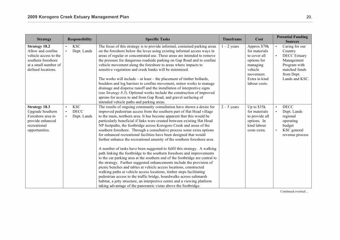
Strategy Responsibility Specific Tasks Timeframe Cost Potential Funding Sources
Strategy 18.2 Allow and confine vehicle access to the southern foreshore at a small number of defined locations.
• KSC • Dept. Lands
The focus of this strategy is to provide informal, contained parking areas on the foreshore below the levee using existing informal access ways in areas of regular or concentrated use. These areas are intended to remove the pressure for dangerous roadside parking on Gap Road and to confine vehicle movement along the foreshore to areas where impacts to sensitive vegetation and creek banks will be minimised. The works will include – at least – the placement of timber bollards, boulders and log barriers to confine movement, minor works to manage drainage and disperse runoff and the installation of interpretive signs (see Strategy 8.3). Optional works include the construction of improved aprons for access to and from Gap Road, and gravel surfacing of intended vehicle paths and parking areas.
1 – 2 years Approx $70k for materials to cover all options for managing vehicle movement. Extra in kind labour costs.
• Caring for our Country
• DECC Estuary Management Program with matched funds from Dept. Lands and KSC.
Strategy 18.3 Upgrade Southern Foreshore area to provide enhanced recreational opportunities.
• KSC • DECC • Dept. Lands
The results of ongoing community consultation have shown a desire for improved pedestrian access from the southern part of Hat Head village to the main, northern area. It has become apparent that this would be particularly beneficial if links were created between existing Hat Head NP footpaths, the footbridge across Korogoro Creek and areas of the southern foreshore. Through a consultative process some extra options for enhanced recreational facilities have been designed that would further enhance the recreational amenity of the southern foreshore area. A number of tasks have been suggested to fulfil this strategy. A walking path linking the footbridge to the southern foreshore and improvements to the car parking area at the southern end of the footbridge are central to the strategy. Further suggested enhancements include the provision of picnic benches and tables at vehicle access locations, constructed walking paths at vehicle access locations, timber steps facilitating pedestrian access to the traffic bridge, boardwalks across saltmarsh habitat, a jetty structure, an interpretive centre and a viewing platform taking advantage of the panoramic vistas above the footbridge.
2 – 5 years Up to $35k for materials to provide all options. In kind labour costs extra.
• DECC • Dept. Lands
regional operating budget
• KSC general revenue process
Continued overleaf…

2009 Korogoro Creek Estuary Management Plan 21.
Strategy Responsibility Specific Tasks Timeframe Cost Potential Funding Sources
Strategy 18.4 Employ strategies to educate creek users about the importance of protecting coastal saltmarsh and the necessity of changes to past access arrangements.
• KSC • Dept. Lands • DECC
(National Parks and Wildlife)
Design and install interpretive anodised aluminium signage around the footbridge and the areas where parking remains (see Appendix 5 for an example sign). Issue press releases to local media detailing the changes, the necessity of managing the area, why it is an improvement and encouraging locals and visitors to respect the new arrangements. Consider the production of a pamphlet for distribution in shops and the caravan park. Other issues requiring education strategies could be consolidated into a single ‘Managing Korogoro Creek’ pamphlet (see Strategies 4.3, 7.2, 8.3, 15.4, and 21.1).
1 – 2 years Approximately $1000 per sign for design production and installation. Savings apply for multiple prints of the same sign. $5k for pamphlet design, printing and distribution, less if combined with other strategies.
• DECC • Crown Lands • KSC

2009 Korogoro Creek Estuary Management Plan 22.
MANAGEMENT ISSUE 3 Priority: HIGH Ranking: 4/21
Effects of climate change and sea level rise on entrance behaviour, hydrology and estuary health.
Supports or is related to the following Management Issues
Management Issue 23 (p.10)
Description
Various scenarios for the possible effects of climate change and sea level rise have been proposed by Australian climate research bodies (eg. CSIRO, 2007) and by international bodies such as the Intergovernmental Panel on Climate Change (IPCC, 2007). Potential impacts on estuaries have also been proposed and include increased rainfall, increased frequency and intensity of extreme weather events, coastal erosion, shoreline realignment, rising water levels in coastal wetlands, changes to entrance morphology, drainage patterns, and tidal flushing characteristics (see Management Issue 23 for a description or Section 4.3 of the Estuary Management Study for more detail). Although the timeframes generally proposed for these changes are beyond the lifespan of this Management Plan (41-91 years; eg. DECC, 2009), it is considered prudent to undertake an investigation of the likely impacts of these changes on the estuary’s hydrology, entrance behaviour and ecology. The NSW Government has recently released a Draft Sea Level Rise Policy Statement which adopts a sea level rise planning benchmark representing an increase above 1990 mean sea levels of 40 cm by 2050 and 90 cm by 2100. It is intended that this benchmark be used to consider the impact of sea level rise on coastal and estuarine habitats, identify valuable habitats at most risk from sea level rise, and assess the impact of changed salinity levels in estuaries.
Figure 4 Areas where entrance behaviour, hydrology and estuary health may be potentially affected by sea level rise under the NSW Governments 2100 benchmark (inferred from Soil Landscape mapping; DECC, 2000) .

2009 Korogoro Creek Estuary Management Plan 23.
Probable changes related to estuary hydrology include changes in entrance dynamics, water quality, areas of tidal influence and inundation, and flow-on effects to ecological distributions in the estuary. For example, estuarine vegetation communities display distinct tidal zone preferences and as a result changes in distribution and extent of some vegetation communities is likely. Of particular interest is the distribution of Coastal Saltmarsh as increased frequency of inundation can result in changes to community structure and the gradual invasion of mangrove species (Saintilan (ed.), 2009). Additionally, Coastal Saltmarsh is often constrained laterally as the low sand/peat benches that it grows upon are limited in distribution, usually perched between the tidal channel and adjacent dunes or higher alluvial deposits (or in Korogoro Creek’s case, an artificial levee). Floodgates on side tributaries and on natural drainage channels limit the intrusion of saline water into adjacent wetland areas, also reducing the potential for these areas to transform into Saltmarsh over time. At this point in time, the impacts upon the broader estuary ecology are unclear with some species and communities expected to benefit whilst others may decline (Saintilan (ed.), 2009). Strategies 3.1 - 3.4 outline a number of actions which will assist in determining the data requirements for investigating the impacts, the management issues likely to arise, and any potential mitigation strategies. It is recommended that unless more accurate scenarios and predictions specific to the mid north coast of NSW become available, then the scenarios used to undertake the investigation are based on the those modelled by CSIRO in their 2008 report on projections for climate change for the Wooli Wooli estuary (see Macadam et al., 2008).
Figure 5 Distribution of Coastal Saltmarsh communities adjacent to the Korogoro Creek estuary which are vulnerable to sea level rise impacts.

2009 Korogoro Creek Estuary Management Plan 24.
Strategies applicable to Management Issue 3
Strategy Responsibility Specific Tasks Timeframe Cost Potential Funding Sources
Strategy 3.1 Assess the likely hydrological changes resulting from current Sea Level Rise scenarios.
• DECC • Dept.
Commerce
Aspects requiring investigation include tidal planes and phasing, tidal prism, a volumetric analysis, tidal flushing, and changes in shoaling behaviour and water levels throughout the estuary. A thorough investigation of potential impacts would be greatly assisted by the availability of a high resolution surface elevation dataset such as that acquired through the use a airbourne laser scanning LiDAR technology. The acquisition of such a dataset is discussed in Strategy 23.1. A less robust method would be to infer landscape elevation through the interpretation of soil landscape units or vegetation classes. Such a method could be made more rigorous by ground-truthing the assumptions of elevation using Digital GPS. Assessments could then be undertaken using either the Wooli Wooli Estuary sea level rise estimations (CSIRO, 2008) or the NSW Government benchmarks for sea level rise (DECC, 2009).
1-2 years Required as a component of Strategy 23.1.
$15k - 20k for the hydro-logical study. Plus ~$150k for Macleay floodplain LiDAR data or $10k -15k for assessment, interpretation and ground-truthing of assumed surface elevations
DECC Estuaries Management Program
Strategy 3.2 Assess the likely effects of hydrological changes on estuary water quality.
• DECC • Dept.
Commerce
Currently available mathematical models do not permit detailed modelling of probable changes at a local or regional scale. However, general trends may be able to be inferred based on the results of Strategy 3.1 above. This assessment will assist in determining the likely impacts of changes in hydrological regime on other areas of interest to estuary management including effects on ecological communities and potential effects on infrastructure such as water supply and effluent disposal (related to Strategy 23.1 and 23.3)
To follow Strategies 23.1 and 3.1
$5k - 10k • DECC Estuary Management Program
Continued overleaf…

2009 Korogoro Creek Estuary Management Plan 25.
Strategy Responsibility Specific Tasks Timeframe Cost Potential Funding Sources
Strategy 3.3 Assess the likely effects of hydrological changes on estuary ecology.
• DECC • DPI
Fisheries
The biological and ecological implications of climate change are very complex and at this stage difficult to predict. Again, general trends can be inferred. For instance, increased salinity levels are likely to be experienced in upper reaches of all estuaries, water temperatures are likely to increase as are inundation levels, and increased temperatures may favour some ecological communities over others (eg. Mangroves over Saltmarsh or some weed species over native species; Saintlan, 2009). This assessment should aim to identify at risk ecology communities in the Korogoro Creek estuary under the scenarios included in either the Wooli Wooli Estuary sea level rise estimations (CSIRO, 2008) or the NSW Government benchmarks for sea level rise (DECC, 2009). As with Strategies 3.1 and 3.2, this action will allow a subsequent analysis of available mitigation strategies under Strategy 3.4 below.
To follow Strategies 23.1, 3.1, and 3.2
$5k - 10k • DECC Estuary Management Program
• DPI Fisheries • NPWS
Strategy 3.4 Plan to mitigate the negative effects of climate change on estuary behaviour and health.
• KSC • Dept. Lands • DECC
Subsequent to Strategies 3.1 - 3.3 above, this Action will allow for mitigation measures to be planned to where possible; • protect vulnerable habitats or communities (eg. endangered
ecological communities such as Coastal Saltmarshes) • compensate for impacts upon valuable habitats or communities (eg.
Removal of floodgates on some levee drains to allow saltwater intrusion, subject to any planning requirements under SEPP14)
• educate local communities on potential impacts and the need for mitigation measures.
To follow Strategies 23.1, 3.1, and 3.2
Assessments to be done “inhouse” by responsible agencies.
• KSC • Dept. Lands • DECC

2009 Korogoro Creek Estuary Management Plan 26.
MANAGEMENT ISSUE 19 Priority: HIGH Ranking: 5/21
Lack of facilities for adequate vehicle access to the southern creek bank for fishing, etc. and resulting unsafe practices in relation to parking on Gap Beach Road between the traffic bridge and the footbridge.
Supports or is related to the following Management Issues
Management Issues 8 (p.36) and 18 (p.18)
Description
Ongoing community consultation has revealed vehicle access to the southern bank of Korogoro Creek to be an issue of concern for a number of reasons (see also issues 8 and 18). The southern bank is popular with recreational fishers in the blackfish season (April – September), with large numbers focussing their efforts on the small, deep hole immediately downstream of the traffic bridge. Further towards the footbridge, picnickers and swimmers are common on the southern bank, particularly in the summer months. These uses, combined with the lack of adequate parking have led to some unsafe and ecologically unsound practices, specifically, roadside parking on the narrow Gap Beach Road and the constant forging of new paths onto the bank below the levee, causing damage to the saltmarsh and other vegetation and contributing to erosion (see Plates 2 & 3, p.19). With these problems in mind, a plan has been drafted for the management of the South Bank of Korogoro Creek between the footbridge and the traffic bridge (see Appendix 2). The plan includes strategies to manage vehicle access and parking in the high use areas of the southern bank.
Figure 6 Area affected by vehicle access and inadequate facilities for safe parking.

2009 Korogoro Creek Estuary Management Plan 27.
Strategies applicable to Management Issue 19
Strategy Responsibility Specific Tasks Timeframe Cost Potential Funding Sources
Strategy 19.1 Provide informal parking on well defined areas of the southern bank below the levee as deemed acceptable by community and stakeholders.
KSC The focus of this strategy is to provide informal, contained parking areas on the foreshore below the levee using existing informal access ways in areas of regular or concentrated use. These areas are intended to remove the pressure for dangerous roadside parking on Gap Road and to confine vehicle movement along the foreshore to areas where impacts to sensitive vegetation and creek banks will be minimised. See Strategies 8.3 and 18.2, and Appendix 2 for details.
1 – 2 years See Strategies 8.3 and 18.2 for details.
DECC Estuary Management Program with matched funds from Dept. Lands and KSC.

2009 Korogoro Creek Estuary Management Plan 28.
MANAGEMENT ISSUE 10 Priority: HIGH Ranking: 6/21
Weed invasion in native vegetation communities along the estuary banks and foreshore.
Supports or is related to the following Management Issues
Management Issue 21 (p.69)
Description
Weed mapping completed in 2007 shows that bitou bush (Chrysanthemoides monilifera), lantana (Lantana camara), and coastal morning glory (Ipomoea cairica) are widespread particularly on the northern creek bank and foreshore (Telfer, 2007). Bitou bush (Chrysanthemoides monilifera), a native of South Africa, was first recorded in Australia at Stockton near Newcastle in 1908. Between 1946 and 1968, it was widely planted to stabilise mined sand dunes. However in 1999, 'invasion of native plant communities by bitou bush and boneseed' was listed as a key threatening process by the NSW Scientific Committee and bitou was declared a Weed of National Significance by the Australian Government in 2000 (DECC, 2006). Lantana (Lantana camara) is scrambling or thicket-forming shrub originating from tropical South and Central America. It was first introduced to Australia in the 1840s as an ornamental garden plant. It has become highly invasive in both agricultural and natural ecosystems and now covers over 5% of the Australian land mass. It poses a serious threat to the survival of numerous plant and animal species, as well as ecological communities and was declared a Weed of National Significance in 1999 (DECC, 2009).
Figure 7 Distribution of the main environmental weed species as per the 2007 survey (see Telfer, 2007).

2009 Korogoro Creek Estuary Management Plan 29.
Coastal morning glory (Ipomoea cairica) originates from tropical Asia and the West Indies. It is a garden escapee that is capable of extremely rapid growth, smothering other vegetation and leading to habitat degradation. Although the seed of all three of these environmental weeds are spread by birds, the practices of dumping garden wastes onto the creek foreshore can also contribute to their spread. Dumping, particularly on the town side of the creek, is also leading to the establishment of many other exotic plants on the foreshore, including garden succulents and other potential environmental weeds.
Strategies applicable to Management Issue 10
Strategy Responsibility Specific Tasks Timeframe Cost Potential Funding Sources
Strategy 10.1 Develop a weed management strategy which prioritises areas of riparian foreshore to be treated and priority weeds to be targeted.
• KSC weed officer Dept. Lands
• NPWS
The main environmental weeds present along the estuary are bitou bush (Chrysanthemoides monilifera), lantana (Lantana camara) and coastal morning glory (Ipomoea cairica). Distribution as mapped in 2007 (see Telfer, 2007) is provided in Figure 7.
It is not recommended to resurvey the area to determine 2009 distributions.
It is recommended to develop a strategy based on existing mapping which; Sets clear objectives for weed management along the estuary over a 5
year timeline. Identifies funding sources Identifies priority areas for control efforts. Defines responsibilities for control works. Outlines appropriate methods for control works in estuarine
environments. Estimates the number of hours required for primary control works
and estimates hours required for maintenance over the 5 year time period.
Outlines a strategy for raising community awareness of actions which can contribute to the spread of environmental weeds along the estuary.
Sets monitoring and evaluation criteria
1-2 years Strategy development $4000 if done external to KSC Weed control funds estimated at 200 hours per year @ $35/hr ($7000/yr) over 5 years.
• Caring for Country
• Dept. Lands • KSC Grants periodically available through Macleay Landcare Network Inc. and the NRCMA.
Continued overleaf…

2009 Korogoro Creek Estuary Management Plan 30.
Strategy Responsibility Specific Tasks Timeframe Cost Potential Funding Sources
Strategy 10.2 Utilise specialist bush regeneration contractors to undertake primary weed control in priority areas.
KSC weeds officer to provide oversight.
Actions as per the Weed Management Strategy developed in Strategy 10.1 above.
1-5 years Subject to the development of Strategy 10.1 above. Minimum of 200 hours per year @ $35/hr ($7000/yr) over 5 years.
Grants periodically available through Macleay Landcare Network Inc. and the NRCMA.
Strategy 10.3 Foster a local Bushcare group to undertake the secondary control or follow-up maintenance of areas treated by contractors.
KSC
Strategy 21.1 defines actions aimed at raising awareness amongst local residents on the sensitivity of the estuary foreshore area and the potential for dumping of garden wastes to spread environmental weeds into the estuarine environment.
Longterm Support available through Macleay Landcare Network Inc.

2009 Korogoro Creek Estuary Management Plan 31.
MANAGEMENT ISSUE 2 Priority: HIGH Ranking: 7/21
Shoaling at the entrance has at times almost closed the creek mouth.
Supports or is related to the following Management Strategies
Management Issues 1 (p.63) and 5 (p.60)
Description
The estuary mouth (Plate 4) has not closed in living memory, however closure would cause significant impacts upon water quality, recreational amenity, and the existing ecological processes in the estuary. An Entrance Management Strategy for Korogoro Creek which proposes trigger conditions for intervention should a significant closure of the entrance occur is outlined in Appendix 1.
Figure 8 Potential area of shoaling affecting the Korogoro Creek estuary entrance.
Plate 4 Korogoro Creek Estuary Entrance has not closed in living memory

2009 Korogoro Creek Estuary Management Plan 32.
Strategies applicable to Management Issue 2
Strategy Responsibility Specific Tasks Timeframe Cost Potential Funding Sources
Strategy 2.1 Develop an Entrance Management Policy that outlines protocols for intervention should the entrance close.
KSC DPI Fisheries Dept Lands DECC
An Entrance Management Strategy for Korogoro Creek Estuary is provided in Appendix 1. In order to address potential issues arising from a hypothetical entrance closure the Entrance Management Strategy should be adopted. In the event of an actual closure the protocols contained within the Entrance Management Strategy should be implemented as necessary.
Completed as part of this Estuary Management Plan. Works only if required as per the protocols in the Entrance Management Strategy.
Nil to adopt the Entrance Management Strategy. Costs for cutting a pilot entrance channel using an excavator and dozer estimated at $5000.
KSC for works funding.

2009 Korogoro Creek Estuary Management Plan 33.
MANAGEMENT ISSUE 16 Priority: MEDIUM Ranking: 8/21
Ongoing monitoring of the groundwater levels and quality immediately below the sewage treatment plant (STP) Effluent Disposal Site has revealed some issues warranting closer attention.
Supports or is related to the following Management Issues
Management Issues 12 (p.40) and 14 (p.55)
Description
Hat Head village was sewered in 2003, replacing most of the septic systems with a sewage treatment plant and a dune based effluent disposal scheme. Appropriate baseline, post commissioning and ongoing monitoring has been undertaken on groundwater sites around the disposal units and limited surface water sites on Korogoro Creek. The results of monitoring have mostly been positive (in terms of no discernable environmental impacts) although the following issues warrant continuing monitoring and possibly management intervention (Cunningham & Timms 2008); The groundwater levels directly below the effluent disposal site have risen
consistently over the period of monitoring; Aluminium concentrations in groundwater below and around the disposal
site appear to have increased since the scheme was in operation; and Inconsistent, but occasional high levels of nitrogen and phosphorus based
nutrient have been recorded at sites below and around the disposal site throughout the monitoring period.
Figure 9 Sewerage Treatment Plant (STP) treated effluent disposal area.

2009 Korogoro Creek Estuary Management Plan 34.
Strategies applicable to Management Issue 16
Strategy Responsibility Specific Tasks Timeframe Cost Potential Funding Sources
Strategy 16.1 Increase the frequency of monitoring of groundwater levels underneath the dune disposal site.
Macleay Water The possibility of further groundwater rises causing a waterlogging of the sands underneath the dune disposal site is a concern because it could reduce the infiltration of pollutants and cause a public health risk. Cunningham and Timms (2008) suggest that more frequent monitoring of groundwater levels is required to determine whether the observed trend of rising groundwater under the disposal site are a result of dune disposal of effluent or some other natural effect, such as higher levels of rainfall recharge. This strategy would be best undertaken by the purchase and installation of four data loggers on existing bores around the dune disposal site. Failing this, or in the interim, the monitoring of groundwater levels could be undertaken by trained council staff on a regular basis.
Immediate and ongoing
Extra monitoring visits cost council staff time. Datalogger purchase approx $6K for 4 loggers.
Monitoring is currently funded by KSC General Sewer Rate
Strategy 16.2 Continue monitoring groundwater quality under and around the effluent disposal site.
Macleay Water The monitoring of groundwater quality has not revealed any clear trends though occasional high levels of certain pollutants have been detected. The suggestions made by Cunningham and Timms (2008) for ongoing monitoring are adequate and should result in improved efficiency of monitoring in addition to detecting any emerging trends.
Immediate and ongoing
Approx. $43k annually
Monitoring is currently funded by Council General Sewer Rate
Continued overleaf…

2009 Korogoro Creek Estuary Management Plan 35.
Strategy Responsibility Specific Tasks Timeframe Cost Potential Funding Sources
Strategy 16.3 Investigate opportunities to relocate the dune disposal site for long term disposal of effluent off site.
Macleay Water The relocation of the dune disposal site would be required under two potential current scenarios: 1) That there is significant and persistent waterlogging of the site causing a reduction in infiltration efficiency and subsequent public health risk, and/or 2) That current climate change associated sea level rise forecasts eventuate, which could potentially cause a further rise in groundwater levels, or remove some of the protection currently offered by the barrier dune system to the east of the disposal site. Under climate change scenarios, options for and the likelihood of relocation of the effluent disposal site will most likely be investigated as part of a Coastal Risk Assessment process for all property and infrastructure (see Strategy 23.1). Note: the timeframe for this strategy may need to be revised pending results from groundwater level monitoring. If chronic waterlogging of the site were to occur in the near future relocation of the site may be a matter of some urgency.
5 – 10 years, pending investigation and monitoring
Approx. $50 – 100K for scoping study and REF
• DECC Coastal or Estuary Management Program
• IWCM Country Town Water Supply and Sewage Program.
• KSC • Dept.
Commerce

2009 Korogoro Creek Estuary Management Plan 36.
MANAGEMENT ISSUE 8 Priority: MEDIUM Ranking: 9/21
Damage to Coastal Saltmarsh Endangered Ecological Community on the southern creek bank foreshore
Supports or is related to the following Management Issues
Management Issues 4 (p.43), 9 (p.67), 10 (p.28), 18 (p.18) and 19 (p.26)
Description
Coastal saltmarsh is recognised as an important estuarine habitat for its contribution as a primary producer and as habitat for juvenile fish. The distribution of saltmarsh has reduced markedly over the last century and Coastal saltmarsh is now listed under the Threatened Species Conservation Act 1995 as an Endangered Ecological Community. This means that a license from the Department of Environment and Climate Change is required to cause damage to saltmarsh and fines are applicable. Saltmarsh habitat occupies the majority of the southern bank of the Korogoro Creek estuary. According to the most recent study there is 0.040 km2 in the Korogoro Creek catchment (NSW DPI Fisheries 2006). Over 75% of this total is under threat from vehicle tracks and associated pressures. The saltmarsh habitat in Korogoro Creek is highly degraded in many areas and is subject to ongoing pressures, mostly from vehicle access along the bank below the southern levee (see Plates 2 and 3, p.19). Saltmarsh vegetation is particularly sensitive to physical pressures. The disturbances in Korogoro Creek fragment the habitat and degrade the soil, limiting the ability of the saltmarsh to regenerate naturally. With management of the saltmarsh and other aspects in mind, a staged and costed site plan has been drafted for the management of the South Bank of Korogoro Creek between the footbridge and the traffic bridge. The plan is included in this report as Appendix 2. Another area of saltmarsh habitat, with similar impacts present is located on the southern bank of Korogoro Creek, upstream of the traffic bridge
Figure 10 Distribution of Coastal Saltmarsh EEC and location of existing vehicle access tracks (see Telfer, 2007)

2009 Korogoro Creek Estuary Management Plan 37.
within the boundary of the Hat Head National Park. It is anticipated that this will be addressed within the next Hat Head National Park Plan of Management. The protection of saltmarsh habitat meets some of the goals of the Northern Rivers Catchment Action Plan (NRCMA 2006) and the Caring for our Country initiative.
Strategies applicable to Management Issue 8
Strategy Responsibility Specific Tasks Timeframe Cost Potential Funding Sources
Strategy 8.1 Restrict vehicle access to areas of coastal saltmarsh.
• KSC • DECC • Dept. Lands • Local
community
The focus of this strategy is to block seven of the existing informal access paths from the levee under Gap Road to the southern foreshore. Low log barriers are considered an appropriate deterrent at each of the 7 sites though other suggestions have included old telegraph poles and large boulders. A site inspection might also reveal a requirement for further materials to restrict potential access at points along the levee not otherwise protected. The area of saltmarsh on the southern foreshore upstream of the traffic bridge would also benefit from restricted vehicle access. The works to restrict vehicle access must be undertaken in a way that does not impede NPWS access to fire trails and KSC access to stormwater/floodgates for maintenance. This Strategy would be more likely to attract funding if a grant application were a joint effort between Kempsey Shire Council, DECC, the Department of Lands and local community groups.
Immediate Approximately $10k for log barriers, up to $2k for cement footings in addition to “in house” labour costs. Extra costs for lockable gates to allow council access to stormwater gates.
• Caring for our Country
• DECC Estuary Management Program with matched funds from Crown Lands and KSC
Continued overleaf…

2009 Korogoro Creek Estuary Management Plan 38.
Strategy Responsibility Specific Tasks Timeframe Cost Potential Funding Sources
Strategy 8.2 Seek appropriate protection for the area of saltmarsh in planning and policy documents.
• KSC • Dept. Lands • DECC
(National Parks and Wildlife)
Upgrade the zoning of the land below the levee on the southern bank of Korogoro Creek between the footbridge and the traffic bridge to Zone E2 – Environmental Conservation or E3 - Environmental Management (under new Standard Provisions for LEPs). The majority of this land is Crown reserve under council management. Changes to zoning will require agreement between the two agencies. Include strategies for the protection and rehabilitation of saltmarsh upstream of the traffic bridge in the updated Hat Head National Park Plan of Management. These strategies might include, for example, strategies to better control vehicle access and to rehabilitate damaged soil and disperse stormwater flows during rain events.
When KSC LEP is updated (<5 years) and when Hat Head NP Plan of Management is updated.
Staff time • KSC, • NPWS • Dept. Lands
Strategy 8.3 Employ strategies to educate creek users about the importance of protecting coastal saltmarsh and the necessity of changing previous arrangements.
• KSC • Dept. Lands • DECC
(National Parks and Wildlife)
Design and install interpretive anodised aluminium signage around the footbridge and the areas where parking remains (see Appendix 5 for an example sign). Issue press releases to local media detailing the changes, the necessity of managing the area, why it is an improvement and encouraging locals and visitors to respect the new arrangements. Consider the production of a pamphlet for distribution in shops and the caravan park. Other issues requiring education strategies could be consolidated into a single ‘Managing Korogoro Creek’ pamphlet (see Strategies 4.3, 7.2, 15.4, 18.4 and 21.1).
1 – 2 years Approx $1000 per sign for design production and installation. Savings apply for multiple prints of the same sign. $5k for pamphlet design, printing and distribution, less if combined with other strategies.
• KSC, • NPWS • Dept. Lands
Continued overleaf…

2009 Korogoro Creek Estuary Management Plan 39.
Strategy Responsibility Specific Tasks Timeframe Cost Potential Funding Sources
Strategy 8.4 Begin active regeneration of vegetation along the levee.
• KSC • DECC • Dept. Lands • Local
community
This strategy is aimed at providing a long term, natural barrier to vehicle movement off the road and on to the bank below. It is planned that eventually, materials used to block the access paths are rendered redundant by significant vegetation growing along the levee. The species already in existence along the levee, such as the Banksia, Leptospermum, Acacia, Casuarina and Eucalyptus spp. Are considered most appropriate and in keeping with the existing environmental values. This Strategy would be more likely to attract funding if a grant application is a joint effort between Kempsey Shire Council, DECC, the Department of Lands and local community groups.
1 year – ongoing
$5k initial costs plus labour for site preparation and 2 years maintenance.
• Caring for Country
• DECC Estuary Management Program with matched funds from KSC, NRCMA, DECC and Dept. Lands
Strategy 8.5 Actively regenerate areas of significantly degraded saltmarsh habitat.
• KSC • DECC • Dept. Lands • Local
community
Remediate areas of degraded saltmarsh where severe impacts and active erosion are occurring by;
• Baffling flows in the areas where they concentrate, to reduce erosion associated with concentrated flows (eg. see Strategy 4.1).
• Regenerating saltmarsh habitat using locally sourced seed stock/propagules and or strategies that promote natural regeneration.
• Monitoring the results and adjusting techniques as necessary. This Strategy would be more likely to attract funding if a grant application is a joint effort between Kempsey Shire Council, DECC, the Department of Lands and local community groups.
2 – 5 years $19k initial costs plus in house labour costs to prepare and vegetate foreshore.
• Caring for Country
• DECC Estuary Management Program

2009 Korogoro Creek Estuary Management Plan 40.
MANAGEMENT ISSUE 12 Priority: MEDIUM Ranking: 10/21
Low dissolved oxygen, high nutrient levels (particularly ammonia) and elevated chlorophyll-a levels have been regularly recorded in the upper reaches of the estuary near the Korogoro Cut floodgates.
Supports or is related to the following Management Issues
Management Issues 11 (p.14) and 14 (p.55)
Description
The Korogoro Creek estuary processes study found that persistently low dissolved oxygen levels and regularly elevated nutrient and chlorophyll-a levels have been recorded from the upper reaches of the estuary. At low tides dissolved oxygen is low throughout the estuary with levels in the upper reaches possibly causing distress to aquatic fauna. At times, fish can be seen at the floodgates gulping and oscillating their operculi, indicating oxygen stress (see Plate 5). Ammonia in waterways tends to be elevated when there are significant sources of rotting plant or animal matter being broken down in oxygen poor conditions, or when reducing conditions are present. It should be noted that the toxicity of ammonia increases with an increase of pH, ie alkaline conditions and also that ammonia is readily utilised as a nutrient by photosynthesising plants. Low dissolved oxygen levels are considered most likely to result from poor quality water leaking through the floodgates, though other potential sources include;
the general lack of disturbance in the upstream area of the creek; lack of significant aquatic vegetation in the upper estuary; high levels of rotting plant matter from riparian vegetation; and, water from the dunal wetland system (SEPP 14 #462) located to the north of
Korogoro Creek.
Figure 11 Area of Korogoro Creek estuary affected by low dissolved oxygen, high nutrients, and elevated Chlorophyll-a levels.

2009 Korogoro Creek Estuary Management Plan 41.
At present the most feasible explanation for elevated nutrients and associated chlorophyll-a is nutrient release from the breakdown of large volumes of vegetative matter sourced from riparian and swamp vegetation. This requires further investigation, other possible explanations being the release of sediment bound nutrients due to the reducing conditions present.
Strategies applicable to Management Issue 12
Strategy Responsibility Specific Tasks Timeframe Cost Potential Funding Sources
Strategy 12.1 Investigate the source of observed water quality issues in the upper estuary.
KSC See Strategies 11.1 and 11.2. Analysis of the water discharging through the Korogoro Cut is considered the best starting point to determine the source of poor quality water in the upper estuary. An attempt to undertake some event based sampling should be made (See Strategy 11.1). It should also include a measurement of the water leaked through the floodgates in either direction over a tidal cycle. Other aspects worth investigating include the water discharged from the dunal wetland (in times of heavy rainfall) to the north of the creek and the contribution from the breakdown of vegetation.
The information gathered in this study would be used to direct further management decisions.
1 – 2years $10k for Strategies 11.1 and 11.2
• DECC Estuary Management program
• KSC
Plate 5 Fish behaviour indicating oxygen stress
Continued overleaf…

2009 Korogoro Creek Estuary Management Plan 42.
Strategy Responsibility Specific Tasks Timeframe Cost Potential Funding Sources
Strategy 12.2 If the source of poor quality water is found to be above the floodgates undertake appropriate actions.
• KSC • DECC
This strategy is dependent on the results of Strategy 12.1. Some works have already been undertaken to reinstate some of the natural hydrology of the Swan Pool and to improve the quality of the water flowing out of it. See Strategy 22.1 for details. Undertake some or all of the suggestions in Smith (2002) to the Korogoro Cut. These include backfilling, levelling and widening the entrance to the cut, in order to avoid draining acidic, deoxygenated groundwater. See also Strategy 22.2.
2 – 5 years, dependent on completion of Strategy 12.1
Dependent on specific strategies chosen. Could be $50k - $200k
• DECC • KSC • Caring for
Country • NRCMA
Strategy 12.3 Investigate other potential options for changes in the management of the floodgates, the Korogoro Cut and the Swanpool.
• KSC • DECC
The feasibility of this option is dependent upon results of Strategy 12.1 and the effectiveness of Strategy 12.2. It would most likely require the services of a qualified consulting firm. The aim of this strategy would be to develop management strategies for the Swan Pool that would have a positive effect on water entering Korogoro Creek through the floodgates. The Korogoro floodgates are a significant part of the Macleay Valley flood mitigation scheme in times of major flood. For this reason management strategies to reduce the impact of the floodgates on Korogoro Creek are likely to be met with sensitivity.
5 – 10 years $20k - 50k for an external study into options.
• DECC • KSC • Caring for
Country • NRCMA

2009 Korogoro Creek Estuary Management Plan 43.
MANAGEMENT ISSUE 4 Priority: MEDIUM Ranking: 11/21
Bank erosion on creek banks between the traffic bridge and the footbridge.
Supports or is related to the following Management Strategies
Management Issues 5 (p.60), 8 (p.36), 9 (p.67), 10 (p.28) and 18 (p.18)
Description
Mapping of bank erosion was completed in the Estuary Processes Study in 2007 (Telfer, 2007). The categories for severity of erosion that were used were;
Minor: where erosion had occurred but processes which led to the erosion were now considered dormant and evidence of natural recovery (such as mangrove colonisation) were apparent
Moderate: where erosion has occurred but processes which led to the erosion were now considered dormant BUT evidence of natural recovery (such as mangrove colonisation) were NOT apparent
Severe: process causing erosion were continuing and no natural recovery mechanisms were apparent
Although no severely eroding sites were recorded in 2007, a revision of the mapping in March 2009 identified a single area of severe erosion on the southern creek bank foreshore where extensive vehicle tracks have led to concentration of stormwater flows and subsequent erosion during high tide/high flow/high wind conditions (see Plate 6). Continued vehicle access in this location is further exacerbating the situation and preventing regeneration of Saltmarsh and mangroves at the site. Remedial action is recommended for this site and would include preventing vehicle access, designing a “soft-engineered” structure to reduce tidal and wind wave
Figure 12 Locations and severity of existing bank erosion and areas recommended for remedial works and further monitoing.

2009 Korogoro Creek Estuary Management Plan 44.
impacts, dissipation of stormwater runoff, and encouragement of mangrove and Saltmarsh regeneration at the site. In other areas of the estuary where sites have been identified with moderate erosion, it is recommended that monitoring be undertaken over the life of this estuary management plan (ie. 2009-2014) and where possible actions taken to promote natural recovery mechanisms such as re-establishment of native riparian vegetation. If implemented, Strategies 18, 10, 8 and 9 include actions that would also contribute to improved creek bank stability.
Strategies applicable to Management Issue 4
Strategy Responsibility Specific Tasks Timeframe Cost Potential Funding Sources
Strategy 4.1 Develop rehabilitation options for the identified priority bank erosion site on the southern creek bank foreshore.
• Dept. Lands • KSC • DECC
Coasts and Estuaries Branch
Remedial action recommended for this site would include preventing vehicle access, designing a “soft-engineered” structure to reduce tidal and wind wave impacts, dissipation of stormwater runoff, and encouragement of mangrove and Saltmarsh regeneration at the site. Design and construction advice should be sort from professional practitioners with experience working with soft-engineered structures in estuarine environments such as the Soil Conservation Service within the Department of Lands.
As soon as practical
$5k - 10k • DECC Estuary Management Program
• Crown Lands Regional operating budget
• KSC Environmental Levy
Plate 6 Foreshore erosion caused by vehicle tracks concentrating stormwater runoff
Continued overleaf…

2009 Korogoro Creek Estuary Management Plan 45.
Strategy Responsibility Specific Tasks Timeframe Cost Potential Funding Sources
Strategy 4.2 Monitor existing sites identified with moderate erosion and where possible take actions to encourage natural recovery mechanisms.
• Dept. Lands • KSC
Areas of moderate erosion show signs of past erosion activity but have no active recovery mechanisms present. Generally speaking where no active recovery mechanisms are present the sites can be considered vulnerable to further erosion, with the rate of erosion being dependant upon site factors such as the level of ongoing disturbance, soil type, processes occurring, etc. Where possible, all disturbances should be removed from the site to encourage natural recovery (eg. Re-establishment of native riparian and aquatic vegetation such as mangroves). Complaints to KSC or another Agency should be dealt with on a site by site basis. If deemed appropriate, a site investigation and where necessary a works design can be provided by the Soil Conservation Service arm of the Department of Lands. A review of bank erosion in the estuary should be undertaken after major flooding or in 2014 when the EMP is reviewed
Over the life of this plan 2009-2014
Staff time for ongoing monitoring. $2.5k for a review/ erosion resurvey. $1k-3k for a site investigation and works design by Soil Conservation Service (Dept. Lands) if required.
• KSC for ongoing monitoring (staff time)
• DECC Estuary Management Program for any works deemed appropriate over the life of this EMP (2009-2014)
• DECC Estuary Management Program for an erosion resurvey.
Strategy 4.3 Raise awareness of estuarine processes and the causes and effects of bank erosion in the estuary.
• KSC • DECC
Coasts and Estuaries Branch
This strategy requires the design and distribution of a pamphlet or brochure explaining Korogoro Creek estuary processes and causes of bank erosion in the estuary. This action could feasibly be combined with other similar actions to increase public awareness of Korogoro Creek management issues such as those included under Strategies 7.2, 8.3, 15.4, 18.4, and 21.1.
1-2 years $5k or less if combined with other similar strategies.
• KSC Environmental Levy
• DECC Estuary Management Program

2009 Korogoro Creek Estuary Management Plan 46.
MANAGEMENT ISSUE 15 Priority: MEDIUM Ranking: 12/21
Preliminary event-based stormwater quality testing indicates high levels of faecal coliforms are entering the estuary from the southern side of Hat Head after moderate rainfall events.
Supports or is related to the following Management Issues
Management Issues 12 (p.40) and 14 (p.55)
Description Stormwater from urban areas is usually a significant contributor to water quality issues in rivers and estuaries (Plates 7 and 8). Stormwater from urban areas often carries, among other things, elevated nutrient loads, sediment loads and pathogens. All of the stormwater from the Hat Head village area flows into Korogoro Creek. Whilst the waters of Korogoro Creek are considered to be generally of good quality the Estuary Data Compilation and Process Study (Telfer, 2007) revealed that no information existed about the effectiveness of stormwater management or stormwater quality in Hat Head village. As part of the Estuary Management Study an initial investigation into stormwater quality and dynamics was undertaken (see GeoLink, 2008 in Telfer and Birch, 2009). Results from that initial study suggested that stormwater quality from the southern (Gap Road) side of town is of poorer quality than the northern side of town. Integrated modelling suggests that this is largely due to the effectiveness of grassed swale treatment measures (see Plates 9 and 10) employed throughout the northern part of the village. Although the pollution levels are not at the upper end of the spectrum for stormwater from urban areas (GeoLink, 2008) it is considered that they warrant further investigation and could feasibly be improved with careful management.
Figure 13 Areas requiring further investigation and improved management to reduce stormwater input of faecal contaminants to the estuary. See Telfer and Birch, 2009

2009 Korogoro Creek Estuary Management Plan 47.
Plate 7 Floodgated stormwater drains
Plate 8 Hard channels deliver stormwater direct to the estuary without opportunity for filtering
Plate 9 Swales provide improve filtering of stormwater before it enters the creek thus reducing pollutant loads (Photo: Tim Ruge, GeoLINK)
Plate 10 Swale drainage adjacent to Gap Road (Photo: Tim Ruge, GeoLINK)

2009 Korogoro Creek Estuary Management Plan 48.
Strategies applicable to Management Issue 15
Strategy Responsibility Specific Tasks Timeframe Cost Potential Funding Sources
Strategy 15.1 Undertake a more thorough stormwater quality analysis.
KSC Undertaking an effective stormwater quality analysis would involve the collection and analysis of up to 5 sets of event based stormwater samples. One of these should be a baseline or low flow type sample.
For consistency it is suggested that samples are collected and analysed using the same methods as those collected for this EMP. Despite this, it is suggested that enterococci be used as the indicator for faecal contamination as opposed to faecal coliforms and that results from a more comprehensive water quality monitoring program be considered in the design of stormwater monitoring strategies. Recent information suggests that enterococci are a more reliable indicator (NHMRC 2008) of human faecal contamination. Additionally, information about the rainfall event and antecedent conditions will assist with the analysis of data and should be collected.
2 – 5 years $10k - $12k • KSC Environmental Levy
• IWCM Country Towns Water Supply and Sewerage Program (if part of an updated IWCM Strategy)
Strategy 15.2 Investigate the source of faecal matter in stormwater, if found in significant concentrations.
KSC The necessity of this strategy is dependent on the results from Strategy 15.1. If faecal contamination in stormwater is detected it is suggested that the source of faecal matter is investigated. This would initially be via a thorough sanitary survey but may also require some faecal sterol testing and follow up sampling dependent upon results. Faecal matter sourced from native animals such as wading birds and kangaroos entering the stormwater system is not a concern warranting further management action.
Upon Completion of Strategy 15.1
$10k KSC Environmental Levy
Strategy 15.3 Undertake strategies to control levels of faecal matter in stormwater.
KSC This strategy is dependent upon the results of Strategy 15.2. Source control of faecal matter in stormwater might require the decommissioning of remaining septic systems and removal of illegal sewage connections to the stormwater system. Treatment measures could feasibly include replacement of concrete drainage channels with grassed swales that promote retention and infiltration. DCP 37 could be amended to include a requirement for grassed swale drainage to service any new development in Hat Head.
Upon Completion of Strategy 15.2
Dependant upon outcome of Strategy 15.2, potentially significant.
NSW Environmental Trust under the Urban Sustainability Program.
Continued overleaf…

2009 Korogoro Creek Estuary Management Plan 49.
Strategy Responsibility Specific Tasks Timeframe Cost Potential Funding Sources
Strategy 15.4 Undertake a public education campaign with the goal of reducing pollutants in stormwater.
KSC A report by GeoLink (2008) contained within the Estuary Management Study (Telfer and Birch, 2008) suggests that the most cost effective stormwater treatment measure for Hat Head would be a public education campaign targeting a reduction of litter in stormwater. This could be easily extended to include other pollutants such as nutrients and faecal matter, if they are found to be of concern. This strategy requires the design and implementation of an educational strategy that could include the distribution of written material and/or installation of signage. This plan contains a number of education strategies that may be combined to greater effect. For example, where signs are required an effort should be made to consolidate issues (refer Strategy 20.2 relating to signage), and where written materials are concerned refer also to Strategies 4.3, 7.2, 8.3, 18.4, and 21.1 relating to information leaflets).
2 – 5 years $50K as per GeoLink, 2008 Design, printing and distribution of a leaflet ~$5k (less if combined with other similar strategies)
Leaflet through DECC Estuary Management Program or KSC. NSW Environmental Trust under the Urban Sustainability Program. As part of an updated IWCM strategy could use funding from Country Towns Water Supply and Sewerage Program.

2009 Korogoro Creek Estuary Management Plan 50.
MANAGEMENT ISSUE 22 Priority: MEDIUM Ranking: 13/21
Swan Pool Management and the effects of Swan Pool drainage on estuary water quality and ecology.
Supports or is related to the following Management Issues
Management Issues 11 (p.14), 12 (p.40), and 14 (p.55)
Description
Flood mitigation projects in the Northern Rivers Catchment Management Area have been linked to water quality problems in estuaries. Poor quality water draining from backswamp areas is most often a result of over drainage and acid sulfate soil disturbance (Tulau, 2002), and decomposing dryland pastures (Johnston et al., 2003, Eyre et al., 2006) (when inundated). Floodplain wetlands subjected to these pressures tend to drain water characterised by acid leachate, low dissolved oxygen and high aluminium and iron content (Tulau, 2002). The management of these backswamp areas is therefore key to estuary water quality. The Swan Pool is an extensive floodplain wetland of the lower Macleay River system (Plate 11). Works associated with the Macleay Valley Flood Mitigation Scheme have altered the hydrology of the system so that it now drains through Korogoro Creek in times of heavy flooding. After the flood mitigation works the Swan Pool was predominantly managed for agricultural purposes, meaning the exclusion of tidal backfilling, drainage of the original pool and the encouragement of dryland pasture species over the natural water tolerant grasses and rushes (Smith 2002). It is likely, though no fine scale mapping has been undertaken, that large areas of actual and/or potential acid sulfate soils occur in and around the drains and natural depressions of the Swan Pool. The entire area was classified as an Acid Sulfate Soil Hotspot (ASS Priority Management Area) by Tulau & Naylor (1999) meaning that ASS management plans should have been developed and implemented. In addition, the encouragement of dryland pasture species may be resulting in poor quality runoff, particularly after flooding.
Figure 14 Swan Pool and its relationship to Korogoro Creek estuary during dry periods and during large floods.

2009 Korogoro Creek Estuary Management Plan 51.
Swan Pool is zoned SEPP 14 and the majority of the wetland is now located within the boundaries of the Hat Head National Park. However, the most recent Hat Head National Park Plan of Management (NSW NPWS 1998) included only a cursory reference to the management of Swan Pool and no specific objectives or tasks were included. It is widely considered that active management of the Swan Pool wetlands would result in improved quality of the runoff directed down Korogoro Creek. The most likely management strategies would focus on the management and modification of the various drainage channels that link the Swan Pool to Korogoro and Kinchela Creeks (with a view to managing surface and groundwater levels) and vegetation management. It is likely that in a reaching a new dynamic equilibrium under altered management, fluctuations in aspects of water quality could be expected but that a long term improvement would be achieved. Monitoring of all management outcomes is recommended.
Strategies applicable to Management Issue 22
Strategy Responsibility Specific Tasks Timeframe Cost Potential Funding Sources
Strategy 22.1 Identify specific water quality and acid sulfate soils issues with the Swan Pool wetland that impact upon Korogoro Creek.
• KSC • DECC • NPWS
Strategies 14 and 12 are required precursors to the completion of this strategy. Water quality monitoring should illustrate the extent of impacts of drainage works on Korogoro Creek.
In addition to the previously mentioned WQ monitoring, this strategy would require a field based survey of areas of the Swan Pool wetland to identify areas of potential and/or actual Acid Sulfate Soils around constructed drains and natural depressions. This initial investigation would also serve to prioritise areas most in need of active management and to suggest potential management strategies for specific problems.
The NPWS have recently purchased some data-logging equipment for continuous monitoring of water levels and salinity at three locations in the Swan Pool. The data obtained may assist in achieving the aims of this strategy.
Upon completion of strategies 14 and 12
Most Likely in house costs for DECC. May require field budget.
• NPWS – Hat Head operating budget
• KSC Floodplain management project.
Plate 11 Aerial view of the Swanpool wetland (Photo: Ron Kemsley, KSC, 2009)
Continued overleaf…

2009 Korogoro Creek Estuary Management Plan 52.
Strategy Responsibility Specific Tasks Timeframe Cost Potential Funding Sources
Strategy 22.2 Continue existing efforts by Kempsey Council, NPWS and Landholders to address Acid Sulfate Soil and wetland management issues and improve the quality of water entering Korogoro Creek during flood times.
KSC DECC Landholders
A variety of projects have been undertaken on in the Kinchela backswamp area to date. The ‘Lock’ has been refurbished, fitted with an auto tidal floodgate and is subject to a plan for active management. An aquatic weed control plan is being written for the Swan Pool area and biological control agent has already been introduced to control Salvinia, a floating aquatic weed. With specific reference to Korogoro Creek, further works that may positively impact the quality of water leaving the Swan Pool will become apparent after the completion of Strategy 22.1. Likely works include; • remediation of active acid sulfate soils; • development of a vegetation regeneration plan; • weed control and removal plan (terrestrial and aquatic weeds); • further encouragement of native wetland flora over dryland pasture
species; • fencing aimed at permanent exclusion of cattle from NPWS land; • identification of an appropriate water level; and • structural works to the Korogoro Cut and other drains to reduce the
tendency to drain groundwater. This strategy would be most likely to attract funding if an application is made combining stakeholder agencies with community groups, educational institutions and indigenous groups.
Ongoing Dependent on specific strategies required.
• NPWS – Hat Head operating budget
• KSC Floodplain management project.
• Caring for Country
Strategy 22.3 Consider further acquisition of Swan Pool area by DECC (NPWS).
NPWS, Landholders
The competing demands of grazing and wetland protection on the Swan Pool have been correctly identified as incompatible (Smith 2002). Acquisition of further lands for incorporation into the Hat Head National Park would allow the area to be managed for environmental values.
5 – 10 years Dependent on land Values
• Caring for Country
• NPWS

2009 Korogoro Creek Estuary Management Plan 53.
MANAGEMENT ISSUE 6 Priority: MEDIUM Ranking: 14/21
Collection of tropical fishes from the creek for aquariums
Supports or is related to the following Management Issues
Management Issue 7 (p.58)
Description
Ongoing community consultation has revealed a concern about the levels of aquarium fish collection from Korogoro Creek waters. Many complaints have been lodged with DPI Fisheries regarding this matter and a decision has been made to ban the collection of aquarium species from Korogoro Creek. The decision was based upon the proximity of other suitable sites for the collection of aquarium species, the need to reduce public conflict and the desire to preserve the area for public benefit (Ian Lyall, pers comm. 2008). The ban itself has been controversial with some members of the broader community arguing that collection of tropical fish can serve an educational purpose and does no long term damage, given that most of the species considered attractive for aquaria, such as the damsel (Pomacentridae), angel (Pomacanthidae) and butterfly (Chaetodontidae) fish families, only recruit to locations such as Korogoro Creek during the warmer months and do not last the winter or breed south of tropical waters (Booth et al. 2007).
Figure 15 Sections of Korogoro Creek known to be used as habitat or suitable as habitat for tropical fish species.

2009 Korogoro Creek Estuary Management Plan 54.
Strategies applicable to Management Issue 6
Strategy Responsibility Specific Tasks Timeframe Cost Potential Funding Sources
Strategy 6.1 Improve documentation and public knowledge of the decision to ban the collection of aquarium fish in Korogoro Creek.
DPI Fisheries This strategy aims to improve public knowledge of the decision to ban aquarium fish collection in Korogoro Creek. There are a number of ways this could be achieved; • Provide a link on the DPI website detailing the ban and its
justification • Education materials such as a pamphlet distributed through local
shops and the caravan park. • Increased patrols from DPI Fisheries officers and occasional visits
from ‘Fishcare’ volunteers targeting this issue during peak holiday times may also prove valuable.
• Press releases to local media. This plan contains a number of education strategies that may be combined to greater effect. For example, where signs and/or pamphlets are required an effort should be made to consolidate issues (refer to Strategy 20.2)
2-5 years Staff time for web link and Fisheries officer patrols. Design, printing and distribution of a leaflet ~$5k (less if combined with other similar strategies)
• DPI Fisheries for web link.
• NSW Recreational Fishing Trust.
Strategy 6.2 Investigate the persistence of tropical fish in Korogoro Creek over the winter months.
• DPI Fisheries
• Community or school group
This strategy would involve a basic survey of notable tropical fish species over the course of a year. It could be undertaken by a community or school group, in conjunction with a local fisheries office. The survey would record water temperature, and the presence of notable tropical fish species such as those from the angel fish (Pomacanthidae), damsel fish (Pomacentridae) and butterfly fish (Chaetodontidae) families.
5-10 years DPI Fisheries staff time to collate and report on results.
DPI Fisheries

2009 Korogoro Creek Estuary Management Plan 55.
MANAGEMENT ISSUE 14 Priority: LOW Ranking: 15/21
The current Water Quality monitoring program is inadequate to determine trends in water quality over time
Supports or is related to the following Management Issues
Management Issues 12 (p.40), 15 (p.46) and 16 (p.33)
Description
Maintaining healthy water quality in an estuary is essential to ecosystem health and inherent recreational values. Effective water quality monitoring is a key aspect of understanding the processes behind water quality and also provides a sound scientific basis for making and justifying management decisions.
A large body of water quality data has been collected from Korogoro Creek over time (summarised in Telfer 2007). The data has been collected under a variety of different programs and, typically for this type of information, a variety of sampling schemes. Whilst the data is an excellent starting point, the utility of the data as a tool for identifying long term trends is limited as in each different program different sites have been sampled and in some cases different parameters have been analysed. At present, surface water quality monitoring in Korogoro Creek is limited to a biannual survey of physical parameters, nutrients, sediment and metals at two locations on the creek and ‘Beachwatch’ monitoring at the estuary mouth during peak holiday season.
An effective water quality sampling program has the following traits; Cost effective; Long term; Regular and consistent; Provides insight into ecological and physical processes within the waterbody;
Figure 16 Recommended Korogoro Creek estuary water quality monitoring program area

2009 Korogoro Creek Estuary Management Plan 56.
Facilitates comparison with prior studies by incorporating existing sites and analytes; and Facilitates comparison with studies in other waterbodies;
Strategies applicable to Management Issue 14
Strategy Responsibility Specific Tasks Timeframe Cost Potential Funding Sources
Strategy 14.1 Develop a water quality sampling program for Korogoro Creek.
KSC The water quality program for Korogoro Creek should at least • Facilitate the identification of trends and issues within the currently
available frameworks • Facilitate comparison with existing data by, for example, analysing
existing sites and parameters • Be meaningful to the management of the creek, with regular
opportunities for review. • Be integrated with water quality sampling programs from similar
nearby waterways.
The water quality monitoring program should include measures for the assessment of water quality against new recreational guidelines set by the NHMRC (2008) as well as ecosystem protection guidelines set by ANZECC (2000). The water quality program will move to replace faecal coliforms with enterococci as the indicator species for faecal matter, in line with current methodology.
The program should include details of sampling and analysis methods, locations, frequency, responsibilities, data use and storage.
A suggested water quality monitoring program is included as an appendix to this report (Appendix 3).
NOTE: An integrated water quality monitoring program for the entire Northern Rivers area is being considered at present by the Northern Rivers Catchment Management Authority. A pilot study for the program is intended for later this year. If such a program was to be undertaken, and Korogoro Creek included, it would most likely fulfil the above criteria.
Within 1 -2 years
A suggested WQ monitoring program is included as part of this EMP.
DECC Estuary Management Program with matched funds from KSC.
Continued overleaf…

2009 Korogoro Creek Estuary Management Plan 57.
Strategy Responsibility Specific Tasks Timeframe Cost Potential Funding Sources
Strategy 14.2 Implement a revised water quality monitoring program.
KSC A water quality monitoring program is an essential aspect of the ongoing monitoring of the health of the Korogoro Creek estuary.
The water quality monitoring program will most likely require some regular sampling activities and analysis at the Port Macquarie water testing laboratory. It is also likely to require some infrequent event based sampling to understand worst case scenario water quality.
It will also require a yearly sanitary survey for classification with respect to recreational water guidelines (NHMRC 2008).
Where possible the program should be integrated with other water quality monitoring such as Swan Pool sampling (see Strategy 11.1, 11.2), Beachwatch sampling and stormwater sampling. In addition, the integration of ecological information such as seagrass depth range, density and condition, mangrove crab counts, etc. can be used to provide an improved picture of overall ecosystem health (See Strategy 11.3 and Appendix 3).
A yearly or two - yearly report and data analysis should be undertaken as part of monitoring, in an effort to determine trends and issues and to review the monitoring procedures.
Within 1 -2 years, ongoing strategy.
Ongoing WQ monitoring to cost $15k-20k for sample collection, analysis and reporting per annum.
DECC Estuary Management Program with matched funds from KSC.
Strategy 14.3 Develop a set of water quality objectives for future management of the Korogoro Creek estuary.
KSC Once a regular monitoring program has been designed and implemented, results will indicate whether or not management intervention to improve water quality is required. The results will also be applicable as a baseline for creating a set of water quality objectives for the future management of Korogoro Creek. Clear guidance for the development of water quality objectives can be found in the ANZECC (2000) guidelines (Section 3).
Upon completion of 2 years of regular monitoring
In house costs or $10k – 20k for external consultant.
DECC Estuary Management Program with matched funds from KSC.

2009 Korogoro Creek Estuary Management Plan 58.
MANAGEMENT ISSUE 7 Priority: LOW Ranking: 16/21
Damage to oyster populations on the southern creek bank downstream of the footbridge and the associated hazards to swimmers
Supports or is related to the following Management Issues
Management Issue 6 (p.53)
Description
Community concerns about the nature of oyster gathering activities in the estuary have been raised in various stages of the consultation process for this plan. In particular, it is suggested that too many oysters are being collected and that the manner in which they are collected leaves dangerous, sharp fragments of shell on the rocks presenting a hazard to recreational users.
Current bag limits for the recreational collection of oysters are 50 per person per day. Fisheries have no policy specifying allowable methods for the collection of oysters but suggest that it should be undertaken with a flat bladed instrument (Lee Burdett, DPI Fisheries, pers comm. 2009).
Strategies to overcome this issue will focus on identifying the specific nature of the problem and on educating creek users.
Figure 17 Area of oyster populations anecdotally reported to be targeted for oyster gathering and burleighing.
Plate 12 Oysters – Korogoro Ck Estuary

2009 Korogoro Creek Estuary Management Plan 59.
Strategies applicable to Management Issue 7
Strategy Responsibility Specific Tasks Timeframe Cost Potential Funding Sources
Strategy 7.1 Assess the health of the Korogoro Creek wild oyster population over time.
• DPI fisheries • Local
community
This would require the design and implementation of an oyster monitoring program undertaken over a number of years. Such programs have been successfully undertaken by community groups in the past, a suggested example can be found at http://www.widebay.net/wcmep/RRW/pdfs/oystersurveyinstructions.pdf. The program would require minimal hardware and be very easy to undertake with limited training. The program would essentially aim to determine the nature and extent of the problem in Korogoro Creek, with a view to determining appropriate management strategies. The program could possibly be undertaken in conjunction with community efforts with respect to monitoring creek ecology (see Strategy 11.3)
Starting within 2 – 4 years
Negligible if undertaken by a community group. Perhaps some costs for internal staff to analyse results
DPI Fisheries
Strategy 7.2 Aim to educate the community about the ecosystem role of oysters, bag limits for recreational gatherers and appropriate methods of oyster harvest.
• DPI fisheries
The most likely vehicle for appropriate education would be a sign and/or pamphlets distributed through local shops or the caravan park. Increased patrols from DPI Fisheries officers and occasional visits from ‘Fishcare’ volunteers targeting this issue during peak holiday times may also prove valuable. Press releases to local media should also be considered. This plan contains a number of education strategies that may be combined to greater effect. For example, where signs are required an effort should be made to consolidate issues (refer Strategy 20.2 relating to signage), and where written materials are concerned refer also to Strategies 4.3, 8.3, 15.4, 18.4, and 21.1 relating to information leaflets).
2 – 5 years Design, printing and distribution of a leaflet ~$5k (less if combined with other similar strategies)
DPI Fisheries

2009 Korogoro Creek Estuary Management Plan 60.
MANAGEMENT ISSUE 5 Priority: LOW Ranking: 17/21
Effects of channel sedimentation including loss of pools and associated habitat and loss of recreational amenity.
Supports or is related to the following Management Strategies
Management Issues 1 (p.63), 2 (p.31), 4 (p.43), 11 (p.14) and 18 (p.18).
Description
The major source of sedimentation in the estuary is from marine derived sands which are pushed into the estuary through the creek mouth by tidal flows, assisted by tidal and ocean currents and wind and ocean waves (Telfer, 2007). Secondary sources include sediments sourced from eroding creek banks particularly between the traffic bridge and footbridge. Anecdotal and aerial photographic evidence suggests that the creek used to contain deeper pools in some locations, particularly in the mid to lower sections of the estuary (see Figure 19). Infilling of the estuary by marine derived sands is a natural long-term process and little can be done in the way of active management short of dredging continuously to remove sediments. Dredging has significant deleterious effects on other aspects of estuary health and is not considered an appropriate long-term strategy to alleviate sedimentation in Korogoro Creek. However, the strategic removal of sands under strict guidelines may be appropriate in the area of the boat ramp during periods of excessive shoaling, or at the entrance in the unlikely event that the estuary mouth closes for a sustained period. Appendix 1 outlines a set of protocols for management of estuary sedimentation in the event that community concerns are raised about sedimentation at the entrance or in the vicinity of the boat ramp. See also Strategies 1.1 and 2.1.
Figure 18 Area affected by increased sedimentation over the period 1942-2009 (see Telfer, 2007).

2009 Korogoro Creek Estuary Management Plan 61.
Figure 19 Comparative aerial photographs showing the location of the flood tide sediment delta in 1942 and 2003. The major source of this sedimentation is
marine derived sands pushed through the entrance by tides and wave action.
The main other source of within-channel sediment is bank erosion. Minimising non-marine sources of sedimentation by implementing strategies to reduce bank erosion along the estuary banks and foreshore will slow channel in-filling. Strategies to minimise bank erosion are detailed in management issues 4 and 18.

2009 Korogoro Creek Estuary Management Plan 62.
Strategies applicable to Management Issue 5
Strategy Responsibility Specific Tasks Timeframe Cost Potential Funding Sources
Strategy 5.1 Limited removal of sands in the vicinity of the boat ramp or at the entrance is permissible under the protocols detailed in the Entrance Management Strategy (see Appendix 1).
• KSC • DPI
Fisheries • Dept. Lands • NSW
Maritime • DECC
Coasts and Estuaries Branch
An entrance management strategy has been formulated as a part of the estuary planning process and is attached as Appendix 1. It is envisaged that this strategy will be adopted as a part of the EMP. The entrance strategy outlines the legal framework, responsibilities, trigger conditions and operational guidelines should complaints about entrance conditions or sedimentation of the boat ramp be received. Actions required are; • Adopt the Korogoro Creek Estuary Entrance Management Strategy
attached as Appendix 1. • Implement the protocols contained within the Entrance Management
Strategy as necessary.
Immediate for adoption of the entrance management strategy. As required by the protocols for any works.
See Strategies 2.1 and 1.1 below for works.
• KSC for entrance works
• KSC or NSW Maritime for boating safety or navigation as per Strategy 1.1
Strategy 5.2 Aim to minimise non-marine sources of within-channel sedimentation by implementing strategies to reduce bank erosion along the estuary banks and foreshore.
• KSC • Dept. Lands • NPWS
Implement actions to minimise bank erosion including those under Strategies 4.1-4.3, 18.1, 18.2, and 18.4.
Immediate for actions in Strategies 4.1, 18.1 and 18.2. 2-5 years for actions in Strategies 4.2, 4.3, and 18.4.
See related strategies.
KSC, Dept. Lands, NPWS depending on land tenure/ management responsibilities.

2009 Korogoro Creek Estuary Management Plan 63.
MANAGEMENT ISSUE 1 Priority: LOW Ranking: 18/21
Difficulty with launching larger vessels has at times necessitated the removal by Council of sand in the vicinity of the boat ramp.
Supports or is related to the following Management Strategies
Management Issues 2 (p.31) and 5 (p.60)
Description
Protocols for management of sedimentation in the vicinity of the boat ramp are discussed in the Entrance Management Strategy attached as an appendix to this Plan (see Appendix 1).
Figure 20 Area of the estuary utilised by vessels for open water ocean access.

2009 Korogoro Creek Estuary Management Plan 64.
Strategies applicable to Management Issue 1
Strategy Responsibility Specific Tasks Timeframe Cost Potential Funding Sources
Strategy 1.1 Develop protocols for removing sands in the vicinity of the boat ramp in conjunction with Strategy 2.1.
• KSC • NSW
Maritime • DPI
Fisheries • Dept Lands • DECC
An Entrance Management Strategy for Korogoro Creek Estuary is provided in Appendix 1. In order to address potential issues arising from sedimentation in the vicinity of the boat ramp the Entrance Management Strategy should be adopted. In the event that sedimentation is deemed to be affecting safety or ease of navigation from the boat ramp to the main navigation channel then the protocols contained within the Entrance Management Strategy should be implemented as necessary.
Completed as part of this Estuary Management Plan. Works would only be undertaken if required as per the protocols in the Entrance Management Strategy.
Nil to adopt the Entrance Management Strategy. Costs for dredging in the vicinity of the boat ramp using a backhoe estimated at $1200. Costs of using an excavator and dozer $3500.
KSC

2009 Korogoro Creek Estuary Management Plan 65.
MANAGEMENT ISSUE 20 Priority: LOW Ranking: 19/21
Boat ramp design and facilities.
Supports or is related to the following Management Strategies
Management Issue 14 (p.55)
Description
The boat ramp and fish cleaning facilities near the mouth of the creek are considered to be generally acceptable. Some boaters are dissatisfied with the rocked edges of the ramp as they create a hazard to boats in peak periods and when strong currents are running. The proliferation of waterways signage has also been identified as an issue by the community and agency stakeholders as the multitude of signs are seen as confusing and to detract from the amenity of the area. Strategy 20.1 recommends the investigation of the potential to retrofit the existing boat ramp (Plate 13) with graded concrete sidings while Strategy 20.2 recommends investigation of the potential for consolidation of the existing signage (Plate 14).
Figure 21 Location of the boat ramp and associated facilities. Plate 13 Hat Head boat ramp showing rocked abutments
Plate 14 The plethora of signs in the vicinity of the Hat Head boat ramp

2009 Korogoro Creek Estuary Management Plan 66.
Strategies applicable to Management Issue 20
Strategy Responsibility Specific Tasks Timeframe Cost Potential Funding Sources
Strategy 20.1 Issues concerning the current design of the boat ramp have been raised in community forums. In particular the rock sidings are considered to be a potential risk to boat hulls.
KSC NSW
Maritime
The potential for retrofitting of the ramp with graded concrete sidings should be considered.
1-2 years Design required prior to costing. Estimated <$15k.
NSW Maritime Infrastructure Program
Strategy 20.2 The proliferation of signage in the vicinity of the boat ramp has been raised in community forums. The potential for consolidation of the signage should be considered by the responsible authorities (ie. DECC, NSW Maritime, NSW DPI Fisheries, Kempsey Shire Council).
KSC NSW
Maritime DECC DPI Fisheries
Options for addressing the proliferation of signage include; Reviewing the existing signage to identify unnecessary, obsolete, or
repetitious information. Redesigning and consolidating the signage to reduce the visual
footprint Relocating some signage away from the foreshore, for instance to the
entrance of the reserve.
1-2 years Indicative costs: Redesign and refabrication of new signs including installation ~$1000 per sign. Physical relocation of existing signs ~$300 per sign.
DECC Estuary Management Program
NSW Maritime NSW
Recreational Fishing Trust

2009 Korogoro Creek Estuary Management Plan 67.
MANAGEMENT ISSUE 9 Priority: LOW Ranking: 20/21
Poor recruitment and regeneration of native vegetation on the southern creek bank foreshore.
Supports or is related to the following Management Strategies
Management Issues 8 (p.36) and 18 (p.18)
Description
There is poor recruitment and regeneration of native riparian species on the southern creek bank foreshore with many older specimens of swamp paperbark (Melaleuca quinquinervia) senescing and areas of Coastal Saltmarsh impacted by access tracks (see Plate 15). As a result habitat availability for species which utilise these trees and scenic amenity are likely to reduce over time unless this trend can be reversed. The impact of vehicle tracks on Saltmarsh is addressed specifically in Strategies 8.1-8.3 and 18.1-18.4. In terms of swamp paperbark, the causes of low regeneration and recruitment are less clear. Strategy 9.1 suggests that an investigation by a professional arborist may assist in determining the causes and possible methods of improving natural regeneration.
Figure 22 Main locations of swamp paperbark remnants on the south bank foreshore.
Plate 15 Melaleucas on the south bank foreshore. Note no regeneration.

2009 Korogoro Creek Estuary Management Plan 68.
Strategies applicable to Management Issue 9
Strategy Responsibility Specific Tasks Timeframe Cost Potential Funding Sources
Strategy 9.1 Investigate the causes of poor recruitment (specifically of Swamp paperbarks, Melaleuca quinquenervia) and attempt to improve recruitment/regeneration using appropriate management strategies.
DECC Dept. Lands KSC
These may include removal of impacts (associated with access tracks; see Strategies 18.1-18.4), assisted regeneration, or non-interference.
1-2 years $3000 for the services of a professional arborist to investigate causes. See Strategies 18.1-18.4 for costs associated with removal of access impacts.
NRCMA DECC KSC
Environmental Levy
Dept. Lands

2009 Korogoro Creek Estuary Management Plan 69.
MANAGEMENT ISSUE 21 Priority: LOW Ranking: 21/21
Littering and dumping of rubbish and garden wastes on the estuary banks and in foreshore areas.
Supports or is related to the following Management Strategies
Management Issue 18 (p.18)
Description
Concern about littering (including fishing tackle and bait packets, takeaway food and drink containers and wrappings, etc.; Plate 16) and the dumping of garden waste in the vicinity of the creek and its foreshore (Plate 17) ranked highly in both Community Surveys (see Telfer, 2007 and Telfer and Birch, 2009). Improved community and visitor awareness may assist in reducing the incidence of littering and dumping around the estuary (see Strategy 21.1). It is also recommended that areas of concentration of litter be investigated and a review of the adequacy of the existing garbage bin infrastructure in those locations be undertaken (Strategy 21.2).
Figure 23 General areas where littering and the dumping of garden rubbish were observed on the foreshore in February 2009.
Plate 16 Littering on the creek bank
Plate 17 Dumping of garden wastes on the foreshore spreads environmental weeds

2009 Korogoro Creek Estuary Management Plan 70.
Strategies applicable to Management Issue 21
Strategy Responsibility Specific Tasks Timeframe Cost Potential Funding Sources
Strategy 21.1 Aim to educate the community and visitors about the sensitivities of the estuary environment and the negative impacts of littering and dumping of garden waste on estuary aesthetics and health.
KSC This strategy requires the design and implementation of an educational campaign that could include the distribution of written material and installation of signage (see Strategy 20.2). Cost savings could be made if the eduction campaign suggested here could be combined with other similar actions suggested in the EMP such as those contained in Strategies 4.3, 7.2, 8.3, 15,4, and 18.4.
1-2 years $5k for design, printing and distribution of an education leaflet. Less if combined with similar Strategies.
KSC Environmental Levy
Strategy 21.2 Investigate areas of concentration of litter and determine adequacy of existing bin infrastructure.
KSC Recommend additional bin locations and review the potential impacts of extra facilities on Council’s current servicing arrangements and the implications for Council’s maintenance regime.
1-2 years ~$600 per double head (fixed head point) bin installation. ~$235 per year for a weekly pickup schedule.
KSC (Environmental Levy)

2009 Korogoro Creek Estuary Management Plan
71.
REFERENCES
Albritton, D.L. et al. (2001). A report of Working Group I of the Intergovernmental Panel on Climate Change; Summary for Policymakers, IPCC.
ANZECC (2000b) Australian Guidelines for Water Quality Monitoring and Reporting.
Australia and New Zealand Environment and Conservation Council (ANZECC) (2000) Australian and New Zealand Guidelines for Fresh and Marine Water Quality
Booth, A. J., Figuera W. F., Gregson, M. A,, Brown L. & Beretta G. (2007) Occurrence of tropical fishes in temperate southeastern Australia : Role of the East Australian Current. Estuarine, Coastal and Shelf Science. 72 pp 102 - 114
Bruun, P. (1962) Sea-Level Rise as a Cause of Shore Erosion. Journal of the Waterways and Harbors Division, Proceedings of the American Society of Civil Engineers, pp117-130.
CSIRO (2007) Climate Change in the Northern Rivers Catchment. Prepared for the NSW Government by the CSIRO.
Cunningham, I. L. & Timms, W. A. (2008) Hat Head Effluent Disposal Scheme – Ongoing Monitoring Results. WRL Technical Report 2008/07
DECC (2006) Bitou Bush Fact Sheet. Published January 2006. http://www.environment.nsw.gov.au/pestsweeds/BitouBushFactsheet.htm
DECC (2008) Climate Change Impacts and Adaptations Research Programs – Aquatic ecosystems. http://www.greenhouse.nsw.gov.au/adaptation/adaptation_research_projects/climate_change_impacts_and_adaptation_research_programs/climate_change_impacts_and_adaptation_research_programs_-_aquatic_ecosystems Accessed July 2008.
DECC (2008b) Summary of Climate Change Impacts – North Coast Region.
DECC (2009a) Draft Sea Level Rise Policy Statement. NSW Department of Environment and Climate Change. http://www.environment.nsw.gov.au/resources/climatechange/09125DraftSLRpolicy.pdf
DECC (2009b) Lantana Fact Sheet. http://www.environment.nsw.gov.au/pestsweeds/Lantana.htm
DWE (2008) Why Protect Estuaries? http://www.naturalresources.nsw.gov.au/estuaries/ whyprotect.shtml Accessed November 2008.
Eyre, B., Kerr, G. & Sullivan, L. (2006) Deoxygenation potential of the Richmond River estuary floodplain, Northern NSW, Australia. River Research and Applications. 22 pp 981 – 992
GeoLink (2008) Stormwater Management Strategy for Hat Head. Prepared for GECO Environmental as part of the Korogoro Creek Estuary Management Study.
Gibbs (2008) Climate Change and the Fisheries of NSW. A Background Paper for NSW Department of Primary Industries.
Healthy Rivers Commission (HRC) (2002) Coastal Lakes – Independent Inquiry into Coastal Lakes.
Hennessy, K. McInnes, D. Abbs, R. Jones, J. Bathols, R. Suppiah, J. Ricketts, T. Rafter, D. Collins* and D. Jones* (2004) Climate Change in New South Wales – Part 2 Projected changes in climate extremes. Climate Impact Group, CSIRO Atmospheric Research.
Houghton, J.T. Meira Filho, L.G., Callander, B.A., Harris, N., Kattenburg, A. and Maskell, K. (eds.) (1996). Climate Change 1995; The science of Climate Change, Cambridge.
IPCC (2001). Climate Change 2001: The Scientific Basis. Contribution of Working Group I to the Third Assessment Report of the Intergovernmental Panel on Climate Change. Cambridge University Press.

2009 Korogoro Creek Estuary Management Plan
72.
IPCC (2007). Climate Change 2007: Synthesis Report. Contribution of Working Groups I, II and III to the Fourth Assessment. Report of the Intergovernmental Panel on Climate Change [Core Writing Team, Pachauri, R.K and Reisinger, A. (eds.)]. IPCC, Geneva, Switzerland, 104 pp.
Johnston, S., Slavich, P., Sullivan, L. & Hirst, P. (2003) Artificial drainage of floodwaters from sulfidic backswamps: effects on deoxygenation in an Australian estuary. Marine and Freshwater Research. 54 pp 781 – 795
Macadam, I., McInnes, K. and O’Grady, J. (2008) Climate change projections for the Wooli Wooli Estuary and Batemeans Bay. A report for the NSW Department of Environment and Climate Change, CSIRO, 27 November 2007.
NHMRC (2008). Guidelines for managing risks in recreational water. National Health and Medical Research Council.
NRCMA (2006) Northern Rivers Catchment Management Action Plan
NSW DPI Fisheries (2006) Aquatic Habitats - GIS Data Set
NSW Government (1992). Estuary Management Manual. NSW Government. October 1992.
NSW National Parks and Wildlife Service (1998) Hat Head National Park Plan of Management
NSW Scientific Community (2004) Coastal Saltmarsh in the NSW North Coast, Sydney Basin and South East Corner Bioregions – Endangered ecological community determination – final DEC (NSW) Sydney http://www.nationalparks.nsw.gov.au/npws.nsf/Content/Coastal_Saltmarsh_endangered
Rahmstorf, S., Cazenave, A., Church, J., Hansen,J. Keeling, R., Parker, D., Somerville, R. (2007) Recent Climate Observations Compared to Projections. Science. 316 p 709
Saintilan, N. (Ed.) (2009) Australian Saltmarsh Ecology. CSIRO Publishing.
SMEC Australia (2007) Climate Change Adaptation Actions for Local Government. Report to the Australian Greenhouse Office, Department of the Environment and Water Resources.
Smith, B. (2002) Swan Pool Drainage Management Project. Report Prepared for Wetland Care Australia.
Telfer, D. (2007) Korogoro Creek Estuary Data Compilation and Processes Study Report. Prepared for Kempsey Shire Council, August, 2007.
Telfer, D. and Birch, M (2009). Korogoro Creek Estuary Management Study Report. Prepared for Kempsey Shire Council, February, 2009.
Tulau, M. (2002) Agricultural Drainage in Acid Sulfate Soil Backswamps in New South Wales – Technical, Regulatory and Policy Responses. DLWC Report.
Tulau, M.J. and Naylor, S.D. (1999). Acid Sulfate Soil Management Priority Areas in the Lower Macleay Floodplain. Report. Department of Land and Water Conservation, Sydney.
~ O ~

Appendix 1 - Korogoro Creek Estuary Entrance Management Strategy
A1-1.
Korogoro Creek Estuary Entrance Management Strategy
Purpose of the Entrance Management Strategy The purpose of this Entrance Management Strategy is to;
1. Acknowledge the natural processes specific to the Korogoro Creek estuary environment and to adopt a general policy of non-interference in the natural processes.
2. Acknowledge that entrance conditions can affect the estuary water quality, ecology and recreational amenity of the creek and that intervention may at times be warranted under agreed Protocols.
3. Describe the main legislative framework governing the ability for local authorities to intervene in the entrance conditions of the Korogoro Creek estuary.
4. Document the Protocols for Entrance Management that determines whether intervention is required.
5. Provide guidance for entrance policy development
The area to which this Entrance Management Strategy applies is from the boat ramp to the creek entrance as depicted in Figure 1.
Figure 1 Area to which the Korogoro Creek Entrance Management Strategy applies
Background Unlike many of the small estuarine creeks along the NSW coast, the Korogoro Creek entrance is considered to be permanently open having not closed in living memory. The state of the entrance appears to be maintained by the orientation of the headland, offshore currents swell and wind conditions, tidal movements and the intermittent operation of the Macleay Valley Flood Mitigation

Appendix 1 - Korogoro Creek Estuary Entrance Management Strategy
A1-2.
Scheme. Shoaling at the entrance is also influenced by these factors and at times the entrance has almost closed. The permanently open entrance conditions are important to many aspects of the health of the Korogoro Creek system and to recreational users who utilise the boat ramp and entrance as a safe ocean access. In summary the open entrance influences: The flushing time of the estuary. Tidal flushing times are entirely dependent upon the status of the
entrance to the estuary. Water quality. Water quality with respect to ecosystem protection and recreational use of estuary
waters is dependent on the tidal flushing of the estuary. Recreational amenity. The above mentioned positive effects on water quality improve the
opportunities for primary contact recreation and recreational harvest of fish and shellfish. The permanently open entrance also makes Korogoro Creek a reliable access point for ocean going recreational craft.
Estuarine ecology. The permanently open entrance allows the free movement of oceanic species. This ensures a constant supply of juvenile fish and allows the estuarine organisms that breed in the open ocean opportunity to migrate. The increased salinity associated with constant tidal incursion has a positive effect on the species diversity of fish, invertebrates and algae. It has been predicted that a significant closure would result in drastic changes in water quality, available habitat and associated biota (Telfer, 2007).
Sedimentation. The rate of infilling of the estuary with marine sourced sands is determined in part by the entrance geometry as well as littoral sand transport, ocean currents, tides, and regularity of flood flows conveyed through the creek.
Maintenance dredging of the entrance has never been undertaken in Korogoro Creek. However, the open entrance has been identified as a key process in maintenance of water quality and estuary health in general. In the case that the Korogoro Creek entrance should close, dredging could be considered as a potential management strategy. Shoaling in the vicinity of the boat ramp has occurred and on at least one occasion has necessitated the removal of sands by the Council. Such action is very infrequent and has not been well documented.
Legislative arrangements allowing intervention. The main legislative mechanism allowing for intervention in Korogoro Creek is found in the State Environmental Planning Policy known as SEPP (Infrastructure) 2007. This policy aims to streamline planning for infrastructure by public authorities within NSW by exempting certain activities from the need for an approval under the Environmental Planning and Assessment Act 1979. It came into effect in January 2008 and replaces a number of existing SEPPs including SEPP 35 (Maintenance dredging of tidal waterways). Of particular relevance to Korogoro Creek, Part 3 of SEPP (Infrastructure) 2007 allows for; 1. Maintenance dredging of sand in the vicinity of the boat ramp under Division 13 Port, wharf or
boating facilities. 1 2. Opening of the estuary entrance under Division 25 Waterway or Foreshore Management
Activities. 2 1 Clause 67 defines “facilities” as including “facilities for the embarkation or disembarkation of passengers onto or from
any vessels, including public ferry wharves” and “wharf or boating facilities” as meaning “a wharf, or facilities associated with a wharf or boating, that are not port facilities”; and Clause 68 (5b) permits without development consent “routine maintenance works (including dredging, or bed profile levelling, of existing navigation channels if it is for safety reasons or in connection with existing facilities).

Appendix 1 - Korogoro Creek Estuary Entrance Management Strategy
A1-3.
Despite the exemption of these activities from the need for consent under the Environmental Planning and Assessment Act 1979, agreement and authorisation is still required from; 1. Department of Lands: If the works are to be carried out on Crown Land, written consent is
required from the Department of Lands, under the provisions of the Crown Lands Act, 1989. The bed of Korogoro Creek is Crown Land.
2. Department of Primary Industries: A dredging permit is required from DPI Fisheries for any subaqueous excavation of bed material, under the provisions of the Fisheries Management Act, 1994, if a permit is not provided by another government authority.
Protocols for Intervention General principles for intervention;
1. The general principle of non-interference will apply except where trigger conditions for intervention exist (as defined below).
2. The general principles of consultation will apply. Kempsey Shire Council is to liase with relevant agency stakeholders including NSW Maritime, NSW DPI Fisheries, DECC Coasts and Estuaries Branch, and Department of Lands as appropriate prior to any intervention. The intention to undertake intervention works and the reasons including the appropriate trigger conditions should be advertised to the local community prior to works commencing.
3. Dredged materials are to be relocated away from the estuary channel and spread evenly upon the beach foredune in such a way that vegetation is not damaged or disturbed. Dredged materials are not permitted to be removed or sold for cost recovery purposes unless authorised by the relevant Agencies.
Trigger Conditions for Intervention
Trigger Conditions for Artificial Entrance Opening Two sets of trigger conditions are relevant to the intervention into Korgoro Creek estuary entrance conditions. They are;
• Water Quality – with trigger conditions based upon the ANZECC (2000) guidelines for the protection of aquatic ecosystems in SE Australian estuaries and the NHMRC (2008) guidelines for recreational water quality
• Flooding – with trigger conditions based upon the presence and extent of local flooding of infrastructure or property.
Under guidelines for managing risks in recreational water developed by the NHMRC (2008) a closure of the Korogoro Creek entrance would be considered an exceptional circumstance and therefore render that system of assessing risk inappropriate. It is therefore suggested that the water quality thresholds contained in the ANZECC (2000) guidelines be adapted for use as the trigger for entrance intervention. Specifically, the parameters to be monitored and the relevant trigger levels to be adopted are contained in Table 1. In the event that the entrance closes, water quality sampling of physical parameters (pH, Temp, D.O, and Secchi depth) are to be undertaken 3 times weekly and nutrient and
2 Clause 128(b) defines “waterway and foreshore management activities” as meaning “instream management or dredging
to rehabilitate aquatic habitat or to maintain or restore environmental flows or tidal flows for ecological purposes”, and Clause 129(1) determines that “development for the purpose of waterway or foreshore management activities may be carried out by or on behalf of a public authority without consent on any land”.

Appendix 1 - Korogoro Creek Estuary Entrance Management Strategy
A1-4.
bacterial samples are to be collected once weekly until such time as management actions are triggered or the entrance opens due to natural causes.
Table 1 Trigger levels for entrance intervention (based on ANZECC, 2000 and adapted for parameters relevant to the management of Korogoro Creek estuary).
Water Quality Variable Threshold Level
Enterococci Median from 4 consecutive samples taken during closure > 35 counts/100mL or, any one sample >60 organisms/100mL
pH < 6 Temperature > 35ºC Dissolved Oxygen < 4mg/L Secchi Depth 1.0m Total Nitrogen 0.3mg/L Total Phosphorus 0.03mg/L
Water Quality Trigger Conditions
Trigger Conditions relating to water quality parameters; • Artificial opening of the Korogoro Creek Entrance should occur if the mean of four consecutive
samples exceeds the trigger value of any parameter (see Table 1), or that any one sample conatins greater than 60 counts/100mL for Enterococci, or that 4 consecutive samples have shown a significant increasing (or decreasing in the case of pH) trend of any parameter over the sampling period.
Flooding Trigger Conditions
Trigger Conditions relating to flooding of infrastructure or property; • In the event that the entrance is closed and local flooding occurs, it is considered that if in the
opinion of Council there is potential for damage to infrastructure or significant damage to property (ie. structural damage) then intervention should occur.
Trigger Conditions for Maintenance Dredging at the boat ramp The shoaling patterns between the boat ramp and the entrance are highly variable being dependant upon tidal currents, sediment supply, entrance conditions, and near shore currents and wave climate. This necessitates a more subjective assessment of the conditions that may trigger the requirement for maintenance dredging, most likely as a result of a complaint or series of complaints to Council or NSW Maritime. The two main factors requiring consideration are boating safety and ease of navigation for vessels of a size appropriate to the facilities. The existence of either or both of the trigger conditions for maintenance dredging at the boat ramp do not infer a requirement upon Council to act as the ability to act will be dependant upon available funding and equipment and/or contractors to undertake the work.
Boating Safety Trigger Conditions
Trigger Conditions relating to Boating Safety; • If after a complaint relating to the safety of launching or retrieving a vessel from the boat ramp is
made it is deemed in the opinion of a NSW Maritime Officer to be unsafe, and that maintenance dredging would resolve the safety issue, then it is appropriate for Council to consider dredging the area of the boat ramp.

Appendix 1 - Korogoro Creek Estuary Entrance Management Strategy
A1-5.
Navigation Trigger Conditions
Trigger Conditions relating to Ease of Navigation; • If after a complaint relating to navigation from the boat ramp to the main channel is made it is
deemed in the opinion of a NSW Maritime Officer to be substantiated, and that maintenance dredging would resolve the navigation issue, then it is appropriate for Council in consultation with relevant Agencies (see Legislative Arrangements) to consider dredging for navigation purposes.
Operational Procedures The operational procedures for management of the Korogoro Creek estuary entrance and sedimentation in the vicinity of the boat ramp are based on existing entrance management strategies applicable to similar ICOLLS in the Kempsey Shire Council area (eg. Killick Creek Estuary Management Plan: WBM Oceanics Australia, 2006). The operational procedures are activated if the entrance closes or if complaints related to the safety or navigability of the access from the boat ramp to the main channel are received. The procedures are summarised in Figure 2 with detailed steps provided below.
Figure 2 Operational procedures for intervention in Korogoro Creek entrance or boat ramp conditions

Appendix 1 - Korogoro Creek Estuary Entrance Management Strategy
A1-6.
Operational Procedures for Entrance Intervention These operational procedures come into effect once the entrance of Korogoro Creek has been closed for one full day. The procedures are as follows; 1. Council officers are to monitor water levels in the creek to assess the potential for significant
damage to infrastructure or property. If water levels exceed the point where damage is likely then proceed to Step 4.
2. Council officers are to carry out periodic water quality monitoring of the estuary. Water quality monitoring shall be carried out three times weekly in respect to the physico-chemical parameters (using a hand-held water quality probe and secchi disc), and once weekly in respect to bacteria (enterococci) and nutrients (TN and TP). In the event of a significant rainfall event (exceeding 20mm in any 24 hour period) all parameters should be sampled. All bacterial samples should be kept chilled before testing by a NATA approved laboratory.
3. Council will compare the water quality results with the specified criteria (refer Table 1). If the water quality criteria are met, then repeat Steps 1-3 until such time that the entrance opens naturally, water levels exceed the threshold where infrastructure or property will be damaged, or the water quality degrades to below the criteria. If the water quality criteria are not met, then proceed to Step 4.
4. Council officers will contact appropriate representatives of the Department Environment and Climate Change – Coasts and Estuaries Branch (DECC), Department of Primary Industries (DPI Fisheries) and the Department of Lands (DoL) to notify them that the trigger conditions for water quality have been exceeded and that intervention is to occur.
5. Council officers will arrange for appropriate earth moving equipment to be mobilised to Hat Head for excavation of the entrance channel. Mobilisation of equipment should be timed to coincide with the most appropriate tidal conditions for entrance breakout (ie. spring tides with a strong diurnal variation in consecutive highs and lows).
6. A channel shall be excavated between the ocean and the creek through the entrance berm. The channel should generally be positioned as close as practical to the bedrock on the southern bank but without interference to the rock. The channel shall grade towards the ocean and will have a width of approximately 5 metres. The invert of the channel shall be at a level of approximately -0.5m AHD. Break-though of estuary waters to the ocean should be timed to occur shortly after the ocean tide turns from high to low for the lowest tide predicted for that day. Appropriate actions should be carried out to ensure public health and safety during the breakout operations.
7. Dredged materials should be spread evenly across the beach foredune in such a manner that no vegetation is disturbed.
Operational Procedures for Dredging These operational procedures come into effect if a complaint is received by Council regarding the safety of launching or retrieving craft from the boat ramp due to excessive sedimentation, or about the ease of navigation from the boat ramp to the main channel due to excessive sedimentation. The procedures are as follows; 1. Council is to notify NSW Maritime of the complaint and arrange a visit to the site to determine the
legitimacy of the complaint. If in the opinion of the NSW Maritime officer the complaint is not substantiated then no action is to be taken. If the complaint is substantiated then proceed to Step 2.
2. Council officers will contact appropriate representatives of the Department Environment and Climate Change – Coasts and Estuaries Branch (DECC), Department of Primary Industries (DPI Fisheries) and the Department of Lands (DoL) to notify them that a condition for dredging at the boat ramp has been triggered and that intervention is to occur.

Appendix 1 - Korogoro Creek Estuary Entrance Management Strategy
A1-7.
3. Council officers will arrange for appropriate earth moving equipment to be mobilised to Hat Head for excavation at the boat ramp. Removal of sands should be timed to coincide with the lowest tide practical in that month’s tidal cycle. Appropriate actions should be carried out to ensure public health and safety during the breakout operations.
4. Dredged materials should be spread evenly across the beach foredune in such a manner that no vegetation is disturbed.
References Australia and New Zealand Environment and Conservation Council (ANZECC) (2000) Australian and New
Zealand Guidelines for Fresh and Marine Water Quality
NHMRC (2008). Guidelines for managing risks in recreational water. National Health and Medical Research Council.
State Environmental Planning Policy (Infrastructure) 2007. New South Wales Department of Planning. http://www.legislation.nsw.gov.au/maintop/view/inforce/epi+641+2007+FIRST+0+N/
Telfer, D. (2007). Korogoro Creek Estuary Processes Study. Report prepared for Kempsey Shire Council.
WBM Oceanic Australia (2006). Appendix A - Interim Entrance Management Protocols. In: Killick Creek Estuary Management Study and Plan.

Appendix 2 – South Bank Foreshore Management Concept Plan
1.
Korogoro Creek South Bank Foreshore Management Concept Plan
Purpose This concept plan contains design proposals developed primarily for managing access to the Korogoro
Creek south bank foreshore area between the traffic bridge and the footbridge. The area is popular
with recreational fishers and 4WD users due to its easy accessibility from Gap Road which runs
parallel to the creek on top of a levee bank some 50 metres to the south. Unrestricted access from the
road has resulted in a network of tracks across the site that have fragmented and damaged the native
cover of saltmarsh vegetation. Coastal Saltmarsh in the North Coast Bioregion (of which Korogoro
Creek is a part) has been determined to be an Ecologically Endangered Community (EEC) under the
Threatened Species Conservation Act 1995.
There is general agreement amongst key stakeholders that the lack of management within the
foreshore area is unacceptable and that remedial measures are essential to address the existing damage
and to prevent further degradation of the EEC. Additional problems associated with access include
damage to the levy and direct and indirect contributions to creek bank erosion. The key aim of these
measures will be to protect existing environmental values by restricting uses that are incompatible
with these values, maintain access for recreational users including vehicle access in defined locations,
improve safety of access, improve access for passive recreational uses, and restore damage to creek
banks and valuable ecological communities.
On this basis, the following strategies were identified for implementation;
The number of access points onto the foreshore area should be reduced from 11 to 3;
Access is to be blocked by incorporating barriers;
Incorporate controls to car movement in locations where access is to be retained. Avoid
providing improvements that may increase pressure on the remnant vegetation and place a
further burden on council services;
Provide signage to educate and advise users of the sensitivity and significance of the natural
saltmarsh community; and
Additional works to enhance recreational possibilities.
South Bank Foreshore Concept Plans The attached Context Plan (Illustration 1) identifies the three access points to be retained (shown as
Detail 1-3) and a proposed new parking area above the footbridge (Detail 4). Concept designs for
each detail area (Illustrations 2-5) and details of possible methods of creating barriers (Illustration 6)
have also been prepared.
The concept designs illustrate possible arrangements of roads, carparks and walking tracks providing
access to key nearby foreshore areas. Indicative regeneration areas have also been identified to
demonstrate their multiple values in terms of their visual, physical and environmental benefit. The
layouts aim to achieve optimal site efficiency while creating discrete, attractive settings for on going,
low-key recreational use that is complementary with the setting.
It is proposed that the concept designs will adopt the following design principles and features:

Appendix 2 – South Bank Foreshore Management Concept Plan
2.
Complementary natural materials and discrete landscape methods to inhibit access and to help
define vehicle and pedestrian movement areas. A number of measures are proposed including:
- Log barriers for short term vehicle control along Gap Road in conjunction with native
tree planting to establish a long term barrier;
- Swales, rock and new vegetation to clearly define tracks into areas where access is to be
retained;
- Large posts to be installed as bollards around carparks to restrict vehicles while
maintaining through pedestrian access; and
- Simple temporary fencing around rehabilitation areas along the foreshore to prevent
pedestrian access, particular in locations that are popular with fishers.
Defined informal walking tracks to key destinations to help guide pedestrian movement and to
control dispersed access across sensitive vegetation. The tracks could be formed with stabilized
earth or gravel to facilitate their maintenance. Boardwalks may also be considered across boggy
ground;
Opportunity for walking tracks to extend beyond each of the three areas to form a continuous
network of linkages for optimal community benefit;
Discrete signage at key locations within carpark areas and along walking tracks to provide users
with advice and interpretive information regarding the saltmarsh environment and its sensitivity
to impacts;
Possible improvement to the levels and gradients of access road junctions with Gap Road to
enhance sight lines and create a safer alignment for car movement;
Possible low key seating or other facilities to enhance the experience for visitors and provide a
focus for social interaction; and
Opportunity for expansion of carparking areas if considered necessary over the longer term.
A rehabilitation program of the saltmarsh community would complement implementation of these
measures. Such a program would require on-going monitoring of the design measures outlined above
to ensure that the control measures have been successful in limiting access across the site as intended.

Appendix 2 – South Bank Foreshore Management Concept Plan
3.

Appendix 2 – South Bank Foreshore Management Concept Plan
4.

Appendix 2 – South Bank Foreshore Management Concept Plan
5.

Appendix 2 – South Bank Foreshore Management Concept Plan
6.

Appendix 2 – South Bank Foreshore Management Concept Plan
7.

Appendix 2 – South Bank Foreshore Management Concept Plan
8.

Appendix 2 – South Bank Foreshore Management Concept Plan
9.
Implementation Costs
The following preliminary cost estimates have been prepared to assist with cost planning associated with implementation of the proposals detailed in this concept plan. The estimates have been ordered
to reflect the likely staging of the work. The removal of seven existing vehicular access points along
Gap Road is considered to have the highest priority while the rehabilitation of degraded foreshore
areas is recommended to occur last as it is understood that much of this area will recover without need for further intervention.
Summary of Costs
1. Gap Road Barriers $16,720
2.1 Detail Area 1 $22,715
2.2 Detail Area 2 $43,972
2.3 Detail Area 3 $27,995 2.4 Detail Area 4 $31,845
3. Rehabilitation of Degraded Foreshore Areas $29,700
Cost Details
1. Gap Road Barriers
Work to seal off 7 existing access points along Gap Road.
Item Description Qty Unit Rate ($) Cost
1. Supply and install 6 x 2.5 metre long log barriers
with two end posts to each site
42 ea 200 8,400
2. Groundwork to existing compacted areas adjacent to Gap Road including weed removal, cultivation
and trimming (say 40 m per site)
280 m 5 1,400
3. Supply and install mass tubestock planting to above areas including 3 plants/m , backfill, mulch,
watering, marker stake and plastic guard (say 40
m per site)
280 m 15 4,200
4 Establishment maintenance including watering, weeding and plant replacement
12 month 100 1,200
Sub-total 15,200
5. 10% Contingency 1,520
TOTAL $16,720
2.1 Detail Area 1
Item Description Qty Unit Rate ($) Cost
1. Silt trap fencing 50 l/m 15 750
2. Construct new apron and ramp to Gap Road
including imported base material, compaction and AC surface
75 m 75 5,625
3. Construct access road and carparking area
including excavation, grading, compaction,
drainage swales, and 50mm imported gravel surface
150 m 20 3,000
4. Construct walking tracks (1 metre wide)
including site clearing, grading, drainage swales,
60 m 15 900

Appendix 2 – South Bank Foreshore Management Concept Plan
10.
Item Description Qty Unit Rate ($) Cost
compaction and 75 mm gravel
5. Rock placement to create barriers (0.5 m min
size)
10 ea 100 1,000
6. Timber bollards @ 1.5 metre centres 15 ea 100 1,500
7. 2.5 metre long log barriers with two end posts 6 ea 200 1,200
8. Temporary protective fencing 30 l/m 10 300
9. Embedded timber steps for pedestrian access to
bridge
15 m 75 1,125
10. Supply and install mass tubestock planting including cultivation, 3 plants/m , backfill,
mulch, watering, marker stake and plastic guard
250 m 15 3,750
11. Signage – interpretive and directional 1 ea 300 300
12. Establishment maintenance including watering, weeding and plant replacement
12 month 100 1,200
Sub-total 20,650
13. 10% Contingency 2,065
TOTAL $22,715
2.2 Detail Area 2
Item Description Qty Unit Rate ($) Cost
1. Silt trap fencing 100 l/m 15 1,500
2. Construct new apron and ramp to Gap Road
including imported base material, compaction and AC surface
75 m 75 5,625
3. Construct access road and carparking area
including excavation, grading, compaction, drainage swales, and 50mm imported gravel
surface
400 m 20 8,000
4. Construct walking tracks (1 metre wide)
including site clearing, grading, drainage swales, compaction and 75 mm gravel
150 m 15 2,250
5. Rock placement to create barriers (0.5 m min
size)
10 ea 100 1,000
6. Timber bollards @ 1.5 metre centres 20 ea 100 2,000
7. 2.5 metre long log barriers with two end posts 10 ea 200 2,000
8. Temporary protective fencing 50 l/m 10 500
9. Supply and install mass tubestock planting
including cultivation, 3 plants/m , backfill, mulch, watering, marker stake and plastic guard
400 m 15 6,000
10. Signage – interpretive and directional 1 ea 300 300
11. Jetty structure PC 4,000
12. Picnic benches and tables PC 2,000
13. Boardwalks across saltmarsh 20 m 150 3,000
14. Establishment maintenance including watering,
weeding and plant replacement
12 month 150 1,800
Sub-total 39,975
15. 10% Contingency 3,997
TOTAL $43,972

Appendix 2 – South Bank Foreshore Management Concept Plan
11.
2.3 Detail Area 3
Item Description Qty Unit Rate ($) Cost
1. Silt trap fencing 60 l/m 15 900
2. Construct new apron to Gap Road including AC
surface
75 m 40 3,000
3. Regrade existing access road and reconfigure carparking area including excavation, grading,
compaction, drainage swales, and 50mm
imported gravel surface
200 m 20 4,000
4. Construct walking tracks (1 metre wide)
including site clearing, grading, drainage swales,
compaction and placement of 75 mm gravel
150 m 15 2,250
5. Rock placement to create barriers (0.5 m min size)
10 ea 100 1,000
6. Timber bollards @ 1.5 metre centres 20 ea 100 2,000
7. 2.5 metre long log barriers with two end posts 10 ea 200 2,000
8. Temporary protective fencing 50 l/m 10 500
9. Supply and install mass tubestock planting including cultivation, 3 plants/m , backfill,
mulch, watering, marker stake and plastic guard
200 m 15 3,000
10. Signage – interpretive and directional 2 ea 300 600
11. Picnic benches and tables PC 2,000
12 Boardwalks across saltmarsh 20 m 150 3,000
13. Establishment maintenance including watering,
weeding and plant replacement
12 month 100 1,200
Sub-total 25,450
14. 10% Contingency 2,545
TOTAL $27,995
2.4 Detail Area 4
Item Description Qty Unit Rate ($) Cost
1. Silt trap fencing 50 l/m 15 750
2. Regrade existing access road and reconfigure
carparking area including excavation, grading,
compaction, drainage swales, and 50mm
imported gravel surface
200 m 20 4,000
3. Construct walking tracks (1 metre wide)
including site clearing, grading, drainage swales,
compaction and placement of 75 mm gravel
80 m 15 1,200
4. Rock placement to create barriers (0.5 m min size)
10 ea 100 1,000
5. Timber bollards @ 1.5 metre centres 20 ea 100 2,000
6. 2.5 metre long log barriers with two end posts 5 ea 200 1,000
7. Temporary protective fencing 50 l/m 10 500
8. Supply and install mass tubestock planting
including cultivation, 3 plants/m , backfill,
mulch, watering, marker stake and plastic guard
200 m 15 3,000
9. Signage – interpretive and directional 1 ea 300 300
10. Picnic benches and tables PC 2,000

Appendix 2 – South Bank Foreshore Management Concept Plan
12.
Item Description Qty Unit Rate ($) Cost
11. Boardwalks 20 m 150 3,000
12. Timber viewing platform PC 6,000
13. Interpretive centre PC 3,000
14. Establishment maintenance including watering, weeding and plant replacement
12 month 100 1,200
Sub-total 28,950
15. 10% Contingency 2,895
TOTAL $31,845
3 Rehabilitation of Degraded Foreshore Areas
Item Description Qty Unit Rate ($) Cost
1. Temporary protective fencing 100 l/m 15 1,500
2. Supply and install mass tubestock planting
including cultivation, 3 plants/m , backfill, mulch, watering, marker stake and plastic guard.
1,500 m 15 22,500
3. Establishment maintenance including watering,
weeding and plant replacement
12 Month 250 3,000
Sub-total 27,000
4. 10% Contingency 2,700
TOTAL 29,700
~ O ~

Appendix 3 - Suggested water quality monitoring program
A3-1.
Water Quality Monitoring Program for Korogoro Creek
Introduction The Korogoro Creek estuary is located at Hat Head NSW. The estuarine region of Korogoro Creek is well defined, owing to the presence of floodgates, approximately 5.4km upstream of the mouth-, which mark the tidal reach. Korogoro Creek is classified as a strandplain-associated coastal creek (National Land and Water Resources Audit Estuarine Condition Assessment, 2002) and is best described as being in healthy modified condition or as slightly to moderately disturbed. Korogoro Creek is highly valued by the local community and visitors as a relatively pristine waterway that provides excellent opportunities for swimming, boating, recreational fishing and observing wildlife (Telfer 2008). It is apparent that a strong level of interest exists for the protection and enhancement of these values. It has become apparent that a long term water quality monitoring program for the Korogoro Creek estuary needs to be designed and implemented (Telfer 2008). Whilst a reasonable quantity of water quality data has been collected over the past 15 years it has been collected under a variety of water quality monitoring programs, limiting its utility as a device for detecting trends or changes in the health of the estuary. This document is intended to provide an example water quality monitoring program for future application to the Korogoro Creek estuary.
Objectives of a Water Quality Monitoring Program for Korogoro Creek Setting clear achievable objectives is an essential part of designing an effective water quality program and generating meaningful data (Maher et al. 1993). Objectives should be based upon a sound understanding of the values and the physical and biological processes of the waterway in question. Community consultation throughout the development of an Estuary Management Plan for Korogoro Creek has shown that Korogoro Creek is widely valued for its recreational values and for its relatively pristine aquatic ecosystems (Telfer 2007, 2008). In addition, the recreational harvest of seafood in the form of fish, prawns and oysters occurs.
Objective 1: Water Quality data collected from the Korogoro Creek estuary should assist managers to protect and enhance the recreational and aquatic ecosystem values identified.
Objective 2: Water Quality data collected from the Korogoro Creek estuary should facilitate comparison with relevant guidelines for the protection of aquatic ecosystems (ANZECC 2000) and recreational use (NHMRC 2008).
The data collected to date indicates that, in general, the water quality of the Korogoro Creek estuary is appropriate for the protection of aquatic ecosystems and for primary contact recreational uses. With this in mind it is desirable that any future trends and changes in water quality are detected. This is further emphasised by the requirement to monitor the effects, if any, of works associated with the Estuary Management Plan.
Objective 3: Water quality data should be collected and analysed in a way that facilitates the detection of significant trends and changes.

Appendix 3 - Suggested water quality monitoring program
A3-2.
Objective 4: Water quality data should provide Kempsey Shire Council and associated stakeholders with a sound platform to make management decisions in the interest of protecting and enhancing the recreational and ecological values of Korogoro Creek.
Kempsey Shire is a predominantly rural area located on the mid-north coast of NSW. The shires population is small relative to its area and the financial resources of the council are reflective of that fact. Hat Head is a town of less than 300 permanent residents. As a holiday village it attracts significant income to the local area. Korogoro Creek is one of four small to medium sized estuaries under control of Kempsey Shire council.
Objective 5: A water quality monitoring program for Korogoro Creek should recognise the limited financial resources of Kempsey Shire Council.
Environmental Pressures and Concerns An effective water quality monitoring program should identify the current environmental pressures and issues of concern that have been identified (ANZECC 2000) Previously collected information have revealed a number of current water quality issues in Korogoro Creek. A summary and analysis of all water quality data collected from Korogoro Creek revealed the following (Telfer 2007);
pH values tend to be below guideline levels throughout the estuary at low tides. This trend is reversed at high tides;
DO is measured at low levels throughout the estuary at low tides. Note that DO needs to be recorded as % saturation to facilitate comparison with ANZECC (2000) guidelines;
Elevated levels of nutrients, particularly nitrogen based species have been recorded throughout the estuary. Corresponding elevated levels of chlorophyll a are observed throughout the estuary on occasion;
No concern about trace metal levels exists; and Occasional high levels of faecal coliforms have been measured, most often during peak
swimming seasons.
Environmental pressures affecting or likely to affect the Korogoro Creek estuary include the following;
Stormwater and litter from the Hat Head township; A site for the dune disposal of effluent, interacting with the creek through groundwater; Connection to the Swan Pool wetland during times of flood; Connection to SEPP 14 wetland number 462 during times of flood; Sediment input from bank erosion; Overflow from remnant septic tanks;

Appendix 3 - Suggested water quality monitoring program
A3-3.
Indicators The indicators are chosen for this study in a way that maximises the opportunities to fulfil the objectives. The choice of indicators also takes into account knowledge of environmental pressures and current water quality issues derived from previous analyses of Korogoro Creek water quality. The relevant guidelines for the protection of aquatic ecosystems and recreational use are the ANZECC (2000) guidelines and the NHMRC (2008) guidelines. These default guidelines are adopted in their entirety for want of locally developed information. The ANZECC (2000) guidelines include a wide range of water quality indicators for the protection of aquatic ecosystems. These include biological indicators such as seagrass depth range and macroinvertebrate population structure, physiochemical parameters such as pH, salinity, dissolved oxygen and turbidity, as well as nutrient, trace metal and toxic organic compounds. The NHMRC guidelines suggest that enterococci are the most suitable indicator of risk to recreational users. For the particular range of issues, environmental stressors and constraints encountered at Korogoro Creek the following list of indicators are suggested as adequate.
Indicator Sampling Method
Comments
Physicochemical pH Probe Most aquatic organisms are not tolerant
of pH extremes. Low pH may be an indicator of acid sulfate soil activity in the Swan Pool. Should be measured throughout the water column.
DO Probe All aquatic life requires oxygen. DO is an indicator of potential stress on aquatic organisms. DO should be measured throughout the water column.
Salinity/Conductivity Probe A useful indicator of the physical status of the waterway. Should be measured throughout the water column.
Temperature Probe Should be measured throughout the water column.
Turbidity Probe Considered an adequate measure of sediment concentration for Korogoro Creek.
Secchi Depth Disk An easily collected indicator of recreational and visual amenity.
Nutrients
Total N and P
Bottle Collect – Laboratory Analysis
Should be analysed as Total N and Total P and also broken up into components.
Biological
Chlorophyll-a
Bottle Collect – Laboratory Analysis
An indicator of nutrient stress and oxygen status.

Appendix 3 - Suggested water quality monitoring program
A3-4.
Indicator Sampling Method
Comments
Seagrass - Epiphyte cover and depth range
Visual inspection
Seagrass – though scarce in Korogoro Creek is considered an efficient indicator of biological function.
Enterococci
Bottle Collect – Laboratory Analysis
Enterococci is now considered the most reliable indicator of faecal contamination and therefore the best indicator of risk to recreational users.
Sampling Methods It is proposed that sampling of all physicochemical, nutrient, bacteriological and chlorophyll-a indicators be undertaken monthly. Seagrass observations should be made annually. A sanitary inspection should be undertaken annually as part of the recreational water quality monitoring. Details of sanitary inspection methods can be found in the NHMRC (2008) Guidelines. Water quality sampling should be undertaken at or near to low tide to ensure consistency between samples and to eliminate the effects of the marine water ingress at high tides. It should be noted that in the case of Korogoro Creek sampling at low tides will provide a worst case scenario picture of water quality. It is also suggested that one independent event-based sample of all physicochemical, nutrient, bacteriological and chlorophyll-a indicators be collected annually. An event-based sample should be obtained within 24 hours of an event where 30mm of precipitation falls in 24 hours.. 3 sampling sites are proposed, at the footbridge, the traffic bridge and the floodgates. These sites maximise data compatibility with the existing sites and correlate with the most upstream parts of three logical conceptual zones of the creek. The footbridge occurs near the most common swimming sites, the traffic bridge is near to the area where groundwater interaction from the effluent disposal site occurs and the floodgates are where the most incidences of poor water quality are observed. In addition these sites provide excellent accessibility. Two methods have been outlined for sampling, a hand held multiprobe for physical parameters that can be measured in the field and bottle sampling of shallow waters for samples requiring a laboratory analysis. All methods for sampling should follow those set out in section 4 of ANZECC (2000b). Methods for the analysis and storage of data should also be sourced from ANZECC (2000b).
Using Guideline Trigger Values In the absence of biological response data from Korogoro Creek or the local area it is considered adequate to adopt the ANZECC (2000) guideline default trigger values for estuarine waters in South East Australia as interim guidelines for Korogoro Creek. The ANZECC (2000) guidelines are designed to be used as a trigger for further investigation. In the case of Korogoro Creek this is most likely to be an investigation into the cause of poor water quality. ANZECC (2000) suggest that the median measured value is statistically the most robust for comparison against guideline values. They also suggest that control charts should be continuously updated as new data is generated so that any triggered action can be undertaken promptly. The ANZECC (2000) guideline values for the protection of aquatic ecosystems applicable for use in this water quality monitoring program are as follows;

Appendix 3 - Suggested water quality monitoring program
A3-5.
Chl-a TP FRP TN NO3 NH4 Ecosystem Type
µgL-1 µgL-1 µgL-1 µgL-1 µgL-1 µgL-1
Estuary 4 30 5 300 15 15
DO (% saturation) pH Salinity
(µScm–1) Turbidity
(NTU) Ecosystem Type
lower upper lower upper lower upper Lower upper
Estuary 80 110 7 8.5 7 N/A 0.5 10
The NHMRC (2008) guidelines are intended to be used in conjunction with an annual sanitary inspection. From the sanitary inspection a preliminary risk category is developed, dependent on the prevalence of potential sources of faecal contamination. A minimum of 20 enterococci samples are then required to generate a microbial water quality assessment category, using a constantly updated 95th percentile value. The advantage of this system is that a proactive approach can be taken to warning the public of any risks associated with the recreational use of waterways.
The relevant NHMRC (2008) guidelines for risk assessment in recreational waters are as follows.
Microbial water quality assessment category (95th percentile value of intestinal enterococci/100mL)
A B C D
≤40 41 - 200 201 - 500 >500
Very Low Very Good Very Good Follow Up Follow Up
Low Very Good Good Follow Up Follow Up
Moderate Good Good Poor Poor
High Good Fair Poor Very Poor
Sanitary Inspection Category (Basic susceptibility to human faecal influence)
Very High Follow Up Fair Poor Very Poor
References ANZECC (2000) Australia and New Zealand Guidelines for Fresh and Marine Water Quality.
ANZECC (2000b) Australian Guidelines for Water Quality Monitoring and Reporting.
Maher, W.A., Cullen, P.W. & Norris, R.H. (1993) Framework for Designing Sampling Programs. Environmental Monitoring and Assessment. 30 pp 139 - 162
NHMRC (2008) Guidelines for Managing Risks in Recreational Water.
Telfer (2007) Korogoro Creek Estuary Data Compilation and Processes Study Report
Telfer and Birch (2009) Korogoro Creek Estuary Management Study. Report prepared for Kempsey Shire Council.

Appendix 4 - Funding Sources
A4-1.
Funding Sources for Implementation of Estuary Management Planning Actions and Strategies
July 2009
Caring for our Country Grants Caring for our Country is the integrated commonwealth approach to environmental investment that replaced the Natural Heritage Trust and associated Envirofund, Regional competitive and Indigenous Heritage programs in 2008.
The goal of Caring for our Country is to achieve an environment that is healthy, better protected, well-managed and resilient, and provides essential ecosystem services in a changing climate. The Australian Government has allocated a total of $2.25 billion to Caring for our Country from 2008–09 to 2012–13.
The Caring for our Country scheme focuses on six national priority areas: the National Reserve System; biodiversity and natural icons; coastal environments and critical aquatic habitats; sustainable farm practices; natural resource management in northern and remote Australia; and community skills, knowledge and engagement. The Government has identified five-year outcomes for each of these priority areas, to be achieved by 2013. The national Landcare program is now also funded under Caring for our Country.
With respect to the Korogoro Creek Estuary Management Plan applications for Caring for our Country funds will benefit from an integrated approach uniting different aspects of the six national priority areas described above. Caring for our Country targets for 2009/10 are likely to attract funding if they target bitou bush, littoral rainforest and or community and indigenous engagement. Caring for our Country grants also fund up to two thirds of land purchases to increase connectivity and extent of the national reserve system.
The 2009/10 round of Caring for our Country Grant proposals close on April 3rd 2009. The grants are administered yearly in line with a yearly business plan that outlines the annual aims, thereby dictating the types of projects most likely to successfully attract funds.
NSW Estuary Management Program Since its introduction in 1992, the Estuary Management Program has provided almost $30 million in grants to 570 local projects across NSW. DNR and subsequently DECC have also provided technical support to more than 40 local councils, as well as collaborative research projects to improve our understanding of estuaries and their natural processes.
The estuary management program is administered now by DECC and is, in conjunction with Caring for our Country grants, likely to be a major source of funding for works aiming to protect and enhance Korogoro Creek for environmental and recreational values.
The completion of an estuary management plan is a prerequisite for attracting funding from the Estuary Management Program.
NSW Coastal Management Program The NSW Coastal Management Program, administered by DECC aims to reduce the impact of coastal hazards, while accommodating population growth. Apart from assisting local councils to develop and implement coastal management plans, the program provides a 50% subsidy to local government for construction works that aim to conserve and/or improve beaches and public reserves, and for the investigation, design and implementation of management measures and works to reduce potential damage from coastal processes in existing developed areas.

Appendix 4 - Funding Sources
A4-2.
NSW Floodplain Management Program DECC allocate funding under the NSW Floodplain Management Program to floodplain risk management programs. The funding is provided on a 2:1 ratio for councils to undertake projects to understand flood risk, assess how it can best be managed, and to implement projects to reduce the flood threat to the community. Projects funded include flood investigations to understand flood behaviour, assess options to develop flood prone land and mitigate flood risk to existing development, and works projects such as the building of levees and detention basins, voluntary purchase and/or raising of houses in areas at high flood risk.
NSW Environmental Trust Grants The NSW Environmental Trust is administered by DECC under the Environmental Trust Act 1998. The trust was established to fund projects that do not attract funding from the usual government sources. Environmental Trust grants are distributed annually. The listed objectives of the program are;
to encourage and support restoration and rehabilitation projects to promote research into environmental problems of any kind to promote environmental education in both the public and private sectors to fund the acquisition of land for the national parks estate to fund the declaration of areas for marine parks and for related purposes to promote waste avoidance, resource recovery and waste management (including funding
enforcement and regulation and local government programs) to fund environmental community groups and to fund the purchase of water entitlements for the purpose of increasing environmental flows for
the State's rivers and restoring or rehabilitating major wetlands.
A number of programs are managed under the general banner of the Environmental Trust. In seeking funds for the implementation of this Estuary Management Plan the most relevant programs are the lead environmental community groups program, the environmental restoration and rehabilitation program and the environmental education program.
Environmental trust grant applications are likely to have improved prospects if they unite 2 or more of the above aims. Further information about the application and assessment procedures can be found at http://www.environment.nsw.gov.au/grants/grantsprocess.htm.
Grants to Voluntary Environment and Heritage Organisations (GVEHO) The GVEHO program aims to help non-profit, community organisations in activities that promote the value, conservation and protection of Australia’s natural and historic heritage. The grants are usually distributed to help these organisations with administrative, travel and training costs. These grants may be applicable to local community organisations such as the Hat Head Bitou Bashers or the Macleay Landcare Network.
Further information about the program can be found at www.environment.gov.au.
NSW Recreational Fishing Trusts The fees collected from the sale of recreational fishing licenses in NSW goes in to one of two trusts dedicated to fishing, one for saltwater and one for freshwater. The funds are distributed upon recommendation by an expenditure committee. Applications for small grants (up to $10000) can be made year round and should be matched by funds or in kind with materials or labour. Applications for large grants are accepted once yearly.

Appendix 4 - Funding Sources
A4-3.
Funds are to be spent in the improvement of recreational fishing with the following target areas;
Enhancing recreational fishing Educating anglers Researching recreational fishing Recreational fisheries access facilities
In general the trusts aim for maximum exposure and place a low priority on commercial ventures, construction of boat ramps and ongoing maintenance such as dredging.
Further information can be sourced from http://www.dpi.nsw.gov.au/fisheries/recreational/licence-fee/apply-for-funds.
NSW Maritime Infrastructure Program The Maritime infrastructure program is managed by NSW Maritime. Approximately $2 million are available annually for projects outside of Sydney that Benefit recreational boaters. The grants are provided with a requirement for matching funds and only apply to infrastructure of a lasting nature with the support of the local council and community. More information is available at http://www.waterways.nsw.gov.au/cv/infra_program.html.
Raising National Water Standards Program This program aims at an improvement in the national capacity to measure, monitor and manage water resources. Funds from the Raising National Water Standards Program are directed at activities across the following areas;
Further implementing the National Water Initiative; Improving integrated water management across Australia; and Improving knowledge and understanding of our water resources.
The focus of the program is on water resources for drinking, agriculture and environmental flows. With respect to Korogoro Creek this program warrants investigation for aspects of Swan Pool management and Groundwater issues. More information is available at http://www.nwc.gov.au/ www/html/347-introduction-to-rnws.asp
Country Towns Water Supply and Sewage Program This program is managed by the Department of Water and Energy and provides management, technical and financial support to local water utilities. The program was originally developed to provide assistance in the creation of infrastructure necessary to meet demands that existed in 1996. There is now a process through the program for funding Integrated Water Cycle Management evaluations and strategies. Integrated Water Cycle Management is a method for councils to manage water supply, stormwater and sewage services for maximum efficiency. Kempsey Shire Council has an Integrated Water Cycle Management Strategy in place that is due for review in 2010.
Green Corps Community organisations with a natural resources project can enter into a partnership with Green Corps to undertake projects of 26 week duration. The requirements are that the agency and project have an environmental and/or heritage focus, provide development opportunities to participants and use best practice principals.

Appendix 4 - Funding Sources
A4-4.
The applicant needs to provide a structured 26 week program, all materials, technical support and opportunities for participants to develop a sense of achievement and a connection with the local community.
Northern Rivers CMA Base Level Funding The CMA base level funding is allocated for on ground works that achieve goals set out in the Northern Rivers Catchment Action Plan. The funding opportunities open and close depending on availability, in turn depending upon the ability of the NRCMA to attract federal funding through the Caring for our Country Program. Funding opportunities are listed on the CMA website when available (http://www.northern.cma.nsw.gov.au).
Department of Lands Regional Operating Budget The Department of Lands administers and manages Crown Land in NSW. The Department of Lands maintains a regional budget for weed control and management on lands under their control.
Strategies in this EMP that focus on works on Crown Lands, e.g. the land on the southern foreshore between the footbridge and the traffic bridge, may be able to utilise Department of Lands funds for signage, weed removal and regeneration.
Kempsey Shire Council General Revenue Process At present funds from Kempsey Shire Council for works relating to the Korogoro Creek Estuary Management Plan will come from the shire’s general revenue process. The distribution of such funds is a matter for council to decide on, upon application for funding by council staff responsible for overseeing the plan and associated works.
Hat Head National Park Budget Funds from the HHNP operating budget are occasionally allocated for monitoring and restoration works for projects such as those covered by the Korogoro Creek Estuary Management Plan.
In general HHNP funds are used to attract further funding for weed control and bush regeneration works through alliances with community groups such as the Macleay Landcare Network and the Hat Head Bitou Bashers.
~ O ~

Appendix 5 – Coastal Saltmarsh interpretative sign example
Approximate costs for installation as follows (prices current January 2009)
SIGN OPTIONS 800x300mm size 650x250mm size
Etched aluminium sign black on silver 1st sign $517 $474
Etched aluminium sign black on silver subsequent sign copies $61 $45
Backing Plate 4mm aluminium $89 $70
Option 1 Aluminium pedestal mount and bolts/brackets $320 $320
Option 2 Galvanised pedestal mount and bolts/brackets $340 $340
Option 3 Stainless steel pedestal mount and bolts/brackets $540 $540
Example sign and costings provided courtesy Kim Luckie, DECC, Coffs Harbour