know how and solutions
TRANSCRIPT

1

1
Content: 1. Brief overview of CSI Ingenieros, and the water area Our clients Know how and solutions The team
2. Different Stormwater projects 3. Carrasco Hydrodynamic Model – Montevideo Master Plan
DIFFERENT CASES APPLIED IN URUGUAY

UNIDAD AGUA Y SANEAMIENTO
3
1 - Brief overview of CSI, and the water area

2
CSI is a worldwide service and consulting engineering company which is focused on emerging countries
Mission Improve quality of living in communities we work for
CSI Ingenieros
Over the years the firm developed a wide range of capacities on different engineering and architectural disciplines, some o f them are:
WATER AND WASTEWATER TRANSPORT PORTS AND WATERWAYS ENVIRONMENT
INDUSTRIAL URBAN DEVELOPEMENT CIVIL ENGINEERING ENERGY
Since 1980, CSI participated in more than 800 projects for governments, international organizations and public and
private sector enterprises in more than 20 countries.

WATER AND WASTEWATER
Water is one of the most precious resources of our planet. Since the mid-eighties, we have worked with our customers to provide safe, reliable and sustainable: water, sanitation and storm systems. Customers of public and private trust us to improve their systems and operations. Combining experience with technology, our team achieved economic and sustainable solutions.

Our clients belongs to the public and private sector, as well as well as international organizations
Water and Wastewater
5

Solutions Feasibility studies Master Plans Preliminary Studies Detailed Designs Tender Documents Technical assistance at works Socio economic and financial assistance
With more than 30 years of experience we are capable of providing international class solutions in order to preserve the hydric resource and promote resilient and sustainable cities taking into account social, technical, economic and financial aspects.
6
Water and Wastewater
Know How Drinking Water production and distribution Domestic Wastewater collection, transport and
treatment Storm Water systems Flooding control Hydraulic Works Industrial wastewater collecting and treatment
Preliminary Studies Strategic Planning Design Procurement

UNIDAD AGUA Y SANEAMIENTO
8
2 – Different Stormwater projects

Sewer and Rainwater Network of Sayago Norte, Peñarol and Ferrocarril Neighborhoods (Montevideo) - 1995
Population to be served at the end of the design period (year 2035) is 30.000 inhabitants. Served Area: 650 hectares.
Modification of Weirs and Auxiliary Works of the Paraguay Wastewater System (Montevideo)- 1997
CSI first projects in stormwater design: 90’s
Hydraulic model: CAREDAS (Sogreah) of the combined sewer network of the Paraguay functional unit (2.920 hectares). The goal of the project is to eliminate discharges to the bay as overflowing during rainfall.

Sewage and Pluvial Network Cerro Norte - La Paloma (Montevideo, 2002)
Storm water projects in vulnerable socio-economic areas
Area: 490 hectares Population: 52.000 inhabitants. Four small streams cross public and private grounds, and are in part flanked by precarious homes, with obstructions and overflow problems caused by garbage and fills without planning.
Sewage and Pluvial Network Rincón del Cerro – Casabó (Montevideo, 2003)
Area: 304 hectares. Population: 34.000 inhabitants A main stream, a dam and several affluents. Precarious homes in the margins, problems of obstructions and overflow.

Plan Set of the Sanitation, Pluvial Waters and Street System of Ciudad de la Costa (Canelones, 2011)
Projects including stormwater retention
Area: 2.150 hectares Population: 99.200 inhabitants. Extremely flat topography. • Retention ponds • Ditch retention
Storm Drainage Project Arroyo Seco y Quitacalzones Basins (Montevideo, 2013)
Area: 1.500 hectares. • 5 closed lamination tanks between
2.000 and 11.000 m3.
Final Plan Set of a Storm Drainage System in Libertad Neighborhood, Juan Lacaze (Colonia, 2013)
• Stormwater pumping station; 3,6 m3/s • A lamination tank of 1500 m3.

Urban Water Plan Ciudad del Plata. (San José)
Projects being developed
Area: 13.000 hectares Population: 30.000 inhabitants. General Objective: long term goals and middle and short term action plan.
Montevideo Sanitary and Urban Drainage Master Plan
Area: 430 km2 Population: 1.350.000 inhabitants.

UNIDAD AGUA Y SANEAMIENTO
13
3 – Carrasco Hydrodynamic Model _ Montevideo Master Plan

Montevideos’ Sewage and Urban Drainage Master Plan
Montevideo Sewage and Drainage towards year 2050
Using integrated modelling as a decision support tool
Most important basins numerically modelled Pantanoso
Miguelete
Paraguay-Costero
Carrasco
Model used: InfoWorks ICM
14

InforWorks ICM from Innovyze
Integrated modeling Precipitation
Hydrology/Subcatchments
Sewer pipes & pump stations
Storm water pipes
Surface flows in streets & inlets
River reaches
Full integration of 1D&2D hydrodynamic simulation techniques
Real Time Control
Water quality and sedimentation
15

Carrasco Catchment Squematization
16
• 135 pluvial subcatchments
• 135 sewage subcatchment
• 99 km of river reaches
• 1441 cross sections (1/68m)
• 14 bridges
• 18 pump stations
• 301 sewage pipes
• 195 streets
• 233 pluvial pipes
• 430 stormwater inlets

Carrasco Catchment Squematization
17
Bridge – Route 102 over Toledo stream

Carrasco – Validation – February 2014
18
Calle Sección Cota relevada (m Wh) Cota modelada (m Wh) Diferencia (m)
Santos Dumont 1410 9.07 9.12 0.05
Abrevadero Manga 1185-1084.2 8.68 8.66 -0.02
B. de la Torre 911 8.61 8.46 -0.15
Calle “N” 787 8.31 8.44 0.13
Bartolomé de los Reyes 787-617 8.26 8.43 0.17

Carrasco - Validation – November 2014
19
Calle Sección Cota relevada (m Wh) Cota modelada (m Wh) Diferencia (m)
Abrevadero Manga 1185-1084.2 7.55 7.82 0.27
B. de la Torre 911 7.61 7.26 -0.35
Bartolomé de los Reyes 787-617 6.64 7.18 0.54

Carrasco – Subcatchments’ specific flows
20
Área TR2 TR10 TR100
Área rural 15.5 24.9 42.9
Área semi-urbana 1 31.1 46.4 75.8
Área semi-urbana 2 22.3 35.3 61.9
Área urbana 1 77.7 108.5 162.1
Área urbana 2 71.4 101.1 153.0
Specific flow (l/s/ha)
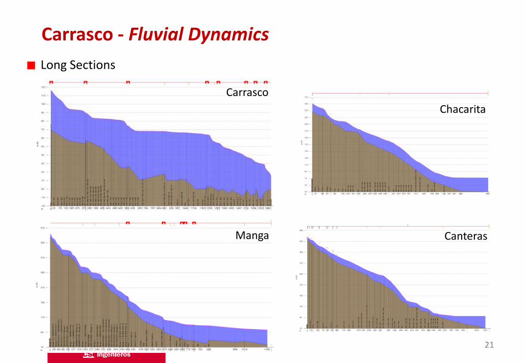
Carrasco - Fluvial Dynamics
21
Long Sections
Carrasco
Manga
Chacarita
Canteras

Carrasco – Fluvial Dynamics
22
Rio de la Plata Level Influence

Carrasco – Fluvial Dynamics
23
Hydrograph propagation
Carrasco – Fluvial Dynamics
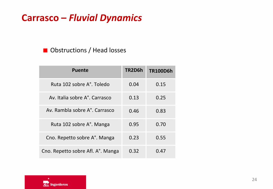
24
Puente TR2D6h TR100D6h
Ruta 102 sobre A°. Toledo 0.04 0.15
Av. Italia sobre A°. Carrasco 0.13 0.25
Av. Rambla sobre A°. Carrasco 0.46 0.83
Ruta 102 sobre A°. Manga 0.95 0.70
Cno. Repetto sobre A°. Manga 0.23 0.55
Cno. Repetto sobre Afl. A°. Manga 0.32 0.47
Obstructions / Head losses

Carrasco – Stormwater Pipes Networks
25
Caudales Perfiles Restricciones Captaciones (con/sin restricciones de bocas de tormenta) Intrusión pluvial
Capacity / Surcharged (%) Velocities (m/s)
Caudales (m3/s)
Pluvial TR2 TR10 TR100
Canteras Sur 7.9 9.0 9.8
Canteras Centro 7.5 10.3 12.0
Canteras Norte 2.0 2.2 2.4
Chacarita Sur 8.7 9.4 10.1
Chacarita Norte 26.6 33.7 38.5
Flows (cms)
Capacity(%)
Green 0.5-1.0
Red > 1.0
Vel (m/s)
Green 0-1
Yellow 1-2
Orange 2-3
Red > 3

Chacarita Norte
Carrasco – Stormwater Pipes Networks
26
Caudales Perfiles Restricciones Captaciones (con/sin restricciones de bocas de tormenta) Intrusión pluvial
Canteras Central
Caudales (m3/s)

27
Carrasco – Surface affectations

Depth of water in streets
Carrasco – Surface affectations
28
Mancha de inundación Permanencia Gráficos de V x D (captura en algún lugar crítico) Inundación / No Inundación
Velocities
Depth (m)
Blue 0.2-0.5
Green 0.5-1.0
Red > 1.0
Vel (m/s)
Green 0-1
Yellow 1-2
Orange 2-3
Red > 3

29
Mancha de inundación Permanencia Gráficos de V x D (captura en algún lugar crítico) Inundación / No Inundación
Hazard
Time flooded
Carrasco – Surface affectations

30
Mancha de inundación Permanencia Gráficos de V x D (captura en algún lugar crítico) Inundación / No Inundación
Spectrum of events affectation
0
10
20
30
40
50
60
70
80
90
100
0 3 6 9 12 15 18 21 24
Inte
nsi
dad
(mm
/h)
Duración (hs)
Tr= 2 años Tr=5 años Tr=10 años
Tr=25 años Tr=50 años Tr=100 años
Veracierto y Saenz de Zumaran Veracierto y Campomar Veracierto y Timoteo Aparicio
Cochabamba y Puntas de Soto Nery y Palencia
NOTA: Veracierto y Saenz de Zumaran, Veracierto y Timoteo Aparicio, y Veracierto y Campomar se inundan para eventos con una recurrencia superior a la analizada.
Carrasco – Surface affectations

Carrasco – Pluvial intrusion
31
Chacarita Sewage Pipe long section
DWF WWF
Infl
ow
P
um
ped

Carrasco – Final comments
Integrated catchment modelling achieved
Model is a tool capable of assessing
DWF
WWF
CSO’s and SSO’s
Land use planning
Identify flood prone areas
Pump station/energy optimization
Structural/non-strucural flood mitigation measures
32

Soriano 1180 Tel.: +598 2902 1066 Fax: +598 2901 9058 E-mail: [email protected] www.csi-ing.com Montevideo 11.100 - Uruguay
33
Thank you for your time
Carla Baldo E-mail: [email protected] Santiago Symonds E-mail: [email protected]