kizu-river integrated reservoir management office · outline of integrated reservoir management...
TRANSCRIPT

TAKAYAMA Reservoir
HINACHI Reservoir
NUNOME Reservoir MUROU Reservoir
KIZU-River Integrated Reservoir Management Office
KIZU-River Integrated Reservoir Management Office
SYORENJI Reservoir
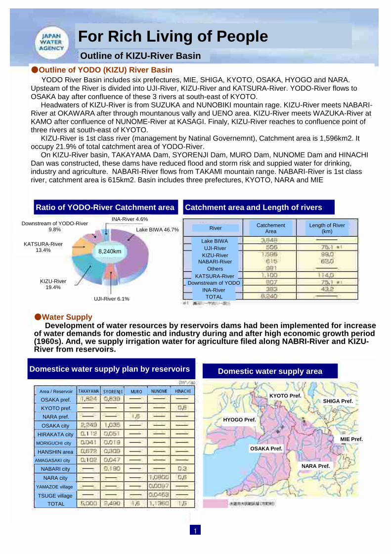
●Outline of YODO (KIZU) River Basin YODO River Basin includes six prefectures, MIE, SHIGA, KYOTO, OSAKA, HYOGO and NARA. Upsteam of the River is divided into UJI-River, KIZU-River and KATSURA-River. YODO-River flows to OSAKA bay after confluence of these 3 rivers at south-east of KYOTO. Headwaters of KIZU-River is from SUZUKA and NUNOBIKI mountain rage. KIZU-River meets NABARI-River at OKAWARA after through mountanous vally and UENO area. KIZU-River meets WAZUKA-River at KAMO after confluence of NUNOME-River at KASAGI. Finaly, KIZU-River reaches to confluence point of three rivers at south-east of KYOTO. KIZU-River is 1st class river (management by Natinal Governemnt), Catchment area is 1,596km2. It occupy 21.9% of total catchment area of YODO-River. On KIZU-River basin, TAKAYAMA Dam, SYORENJI Dam, MURO Dam, NUNOME Dam and HINACHI Dan was constructed, these dams have reduced flood and storm risk and suppied water for drinking, industry and agriculture. NABARI-River flows from TAKAMI mountain range. NABARI-River is 1st class river, catchment area is 615km2. Basin includes three prefectures, KYOTO, NARA and MIE
For Rich Living of People Outline of KIZU-River Basin
Ratio of YODO-River Catchment area Catchment area and Length of rivers
8,240km
INA-River 4.6%
Lake BIWA 46.7%
UJI-River 6.1%
KIZU-River 19.4%
KATSURA-River 13.4%
Downstream of YODO-River 9.8% River
Lake BIWA UJI-River
KIZU-River NABARI-River
Others KATSURA-River
Downstream of YODO INA-River
TOTAL
Catchement Area
Length of River (km)
●Water Supply Development of water resources by reservoirs dams had been implemented for increase of water demands for domestic and industry during and after high economic growth period (1960s). And, we supply irrigation water for agriculture filed along NABRI-River and KIZU-River from reservoirs.
Domestice water supply plan by reservoirs Domestic water supply area
Area / Reservoir
OSAKA pref. KYOTO pref. NARA pref.
OSAKA city HIRAKATA city
MORIGUCHI city
HANSHIN area AMAGASAKI city
NABARI city
NARA city YAMAZOE village
TSUGE village TOTAL
TAKAYAMA SYORENJI MURO NUNOME HINACHI KYOTO Pref.
HYOGO Pref.
OSAKA Pref.
NARA Pref.
SHIGA Pref.
MIE Pref.
1

Map of KIZU-River Basin
2
For Effective Management Outline of KIZU-River Basin
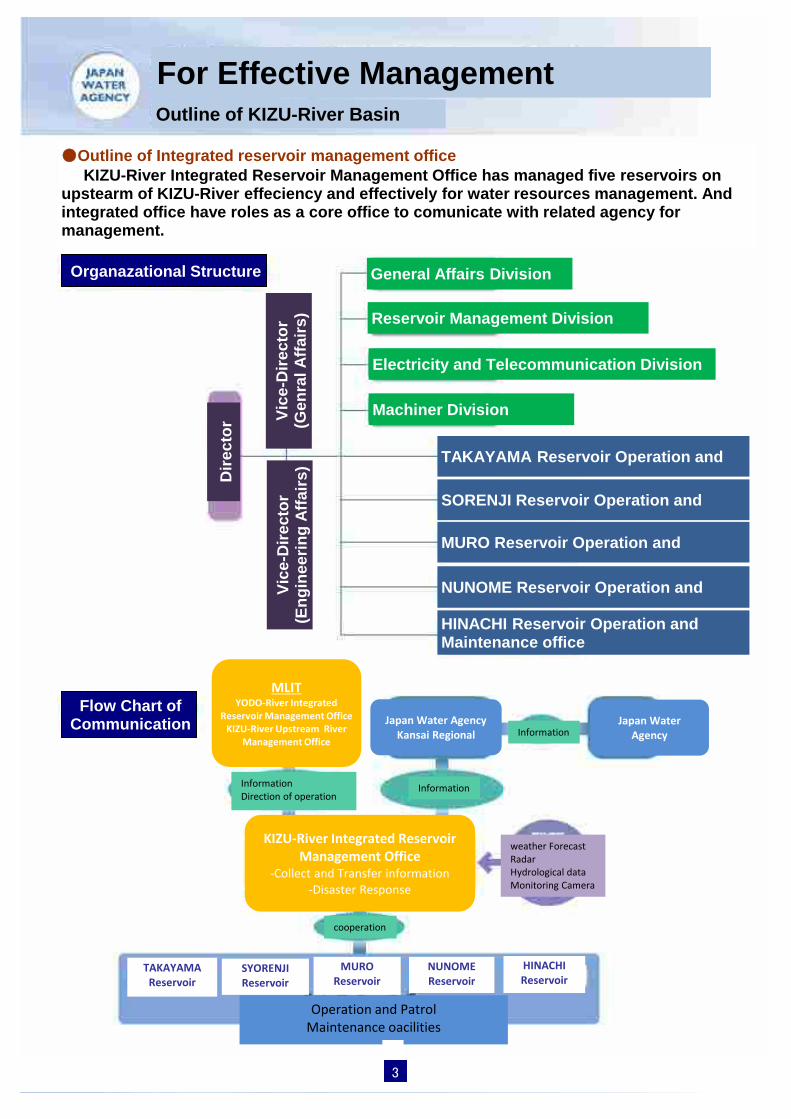
●Outline of Integrated reservoir management office KIZU-River Integrated Reservoir Management Office has managed five reservoirs on upstearm of KIZU-River effeciency and effectively for water resources management. And integrated office have roles as a core office to comunicate with related agency for management.
Organazational Structure
Dire
ctor
Vice
-Dire
ctor
(G
enra
l Affa
irs)
Vice
-Dire
ctor
(E
ngin
eerin
g Af
fairs
) General Affairs Division
Reservoir Management Division
Electricity and Telecommunication Division
Machiner Division
TAKAYAMA Reservoir Operation and
SORENJI Reservoir Operation and
MURO Reservoir Operation and
NUNOME Reservoir Operation and
HINACHI Reservoir Operation and Maintenance office
Flow Chart of Communication
KIZU-River Integrated Reservoir Management Office
-Collect and Transfer information -Disaster Response
MLIT YODO-River Integrated
Reservoir Management Office KIZU-River Upstream River
Management Office
Japan Water Agency Kansai Regional
Japan Water Agency
Information Direction of operation
Information
cooperation
Information
weather Forecast Radar Hydrological data Monitoring Camera
TAKAYAMA Reservoir
SYORENJI Reservoir
MURO Reservoir
NUNOME Reservoir
HINACHI Reservoir
Operation and Patrol Maintenance oacilities
3

Telecommunication System for Integrated Reservoir Management
●Outline of Telecommunication System KIZU-River Integrated Reservoir Management Office has communication line with not only five reservoirs but also YODO-River Integrated Reservoir Management Office, KIZU upstream River Management office and Japan Water Agency Headquators and Kansai Regional Office. These communication lines are consist of strong radio signal that is stable against disaster. we manage reservoirs effectively and effeciency with collecting hydorological data (Water Level, Rainfall, etc) for water supply and flood control.
Telephone line and Network
Radar, (Rainfall observation)
Telemer (Water Level, Rainfall data)
Optical Fiber Cable (Monitoriing Video
4
Leg
end

5

Data and Information Management for Interated Reservoir Management
It is necessary for 5 reservoirs integrated management to observe and collect hydrological data(River Water Level, Rainfall, Reservoir data) on Real-Time. We manage the information and data through telecommunication control facility for 24 hours.
TAKAYAMA, SYORENJI, MURO, NUNOME, HINACHI
Hydro-data Video Rainfall River Water
Meteorology Earthquake Rainfall-Density
Reservoir Telemeter Meteorological Radar
Water Inflow
Discharge Intake
Upstream
Others Others
Downstream Reservoir Rainfall
31 stations River Water Level
30 stations
Satellate Rainfall
Forecast Typhoon
Whole country KINKI Region
YODO-River Basin Forecast
Warning
Seismic Intensity
Rainfall History
Reservoir River
YODO-River Integrated Reservoir Managemenrt Office (MLIT)
Water Inflow
Discharge Intake
Flow
Others Rainfal
System
Hydro-data
KIZU- River Upstream Managemenrt Office (MLIT)
Japan Water Agency KANSAI Regional Office
Flood
Reservoir Data
Reservoir Video
Water Inflow
Discharge Intake
Upstream
Others Others
DownstreaWater
Mobile data communication
River Montoring Reservoir data
Reservoir Data River Flow Meteorological Data Radar
KIZU-River Integrated Reservoir Management Office
Telecommunication
Server Display of Reservoir data, River Flow and Reservoir Monitoring Video
6
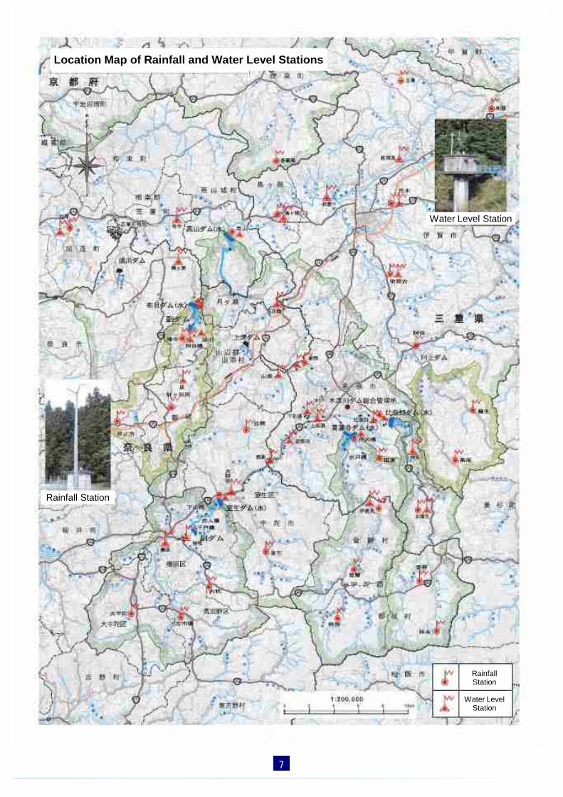
Location Map of Rainfall and Water Level Stations
Water Level Station
Rainfall Station
Water Level Station
Rainfall Station
7
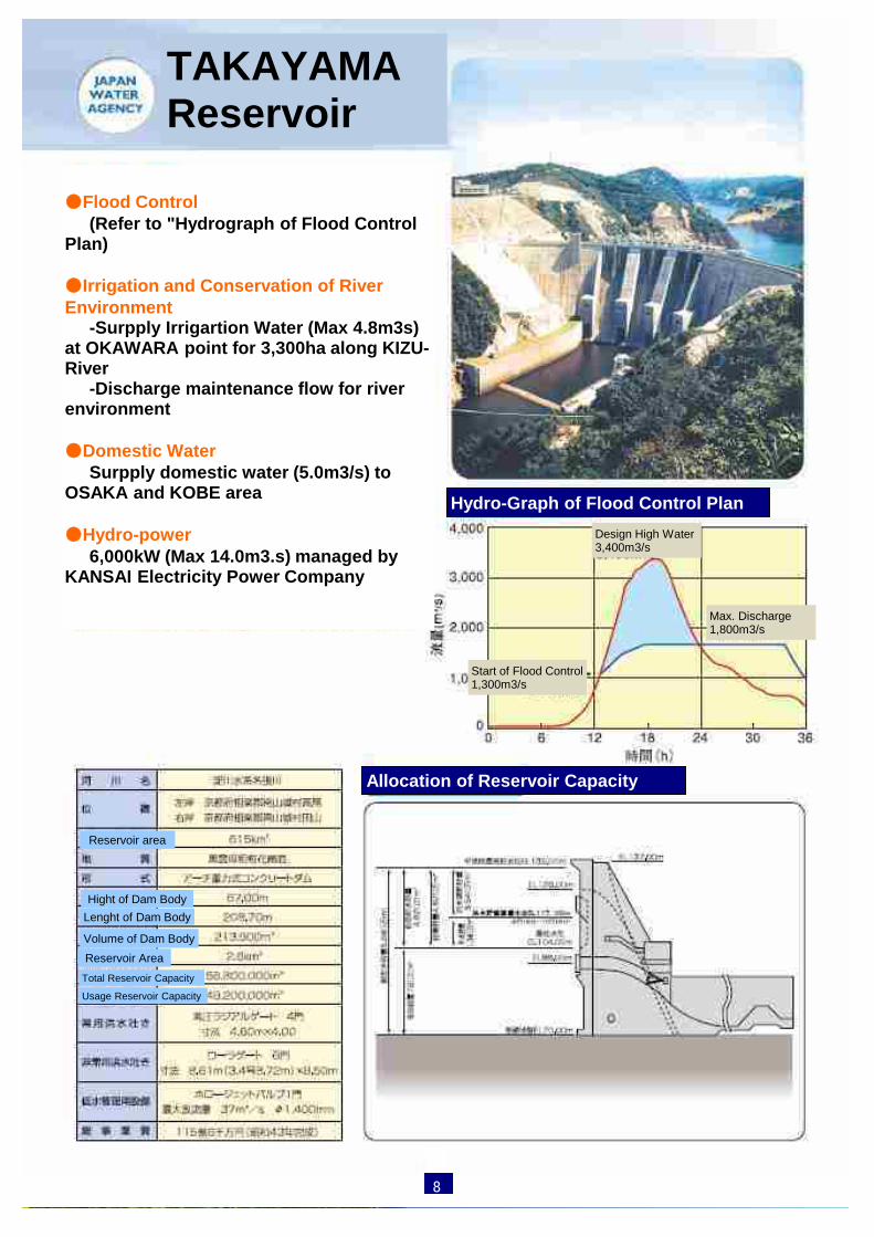
●Flood Control (Refer to "Hydrograph of Flood Control Plan) ●Irrigation and Conservation of River Environment -Surpply Irrigartion Water (Max 4.8m3s) at OKAWARA point for 3,300ha along KIZU-River -Discharge maintenance flow for river environment ●Domestic Water Surpply domestic water (5.0m3/s) to OSAKA and KOBE area ●Hydro-power 6,000kW (Max 14.0m3.s) managed by KANSAI Electricity Power Company
Hydro-Graph of Flood Control Plan
TAKAYAMA Reservoir
Design High Water 3,400m3/s
Start of Flood Control 1,300m3/s
Max. Discharge 1,800m3/s
Reservoir area
Hight of Dam Body Lenght of Dam Body
Volume of Dam Body Reservoir Area
Allocation of Reservoir Capacity
8
Total Reservoir Capacity
Usage Reservoir Capacity

9

●Flood Control (Refer to "Hydrograph of Flood Control Plan) ●Irrigation and Conservation of River Environment -Supply Irrigartion Water (Max. 1.3m3s) at OKAWARA point for 3,300ha along KIZU-River -Supply Irrigation Water (Max. 1.66m3/s) for 125ha along KIZU-River in NABARI area -Discharge maintenance flow for river environment ●Domestic Water -Supply domestic water (2.3m3/s) to OSAKA and KOBE area -Supply domestic water (0.19m3/s) to NABARI-city ●Irrigation Water -Supply irrigation water (1.72m3/s) to NABARI area ●Hydro-power 2,000kW (Max 3.9m3.s) managed by MIE Prefecture
Hydro-Graph of Flood Control Plan
SYORENJI Reservoir
Inflow
Discharge
Reservoir area
Hight of Dam Body Lenght of Dam Body
Volume of Dam Body Reservoir Area
Allocation of Reservoir Capacity
10
Total Reservoir Capacity
Usage Reservoir Capacity

11

●Flood Control (Refer to "Hydrograph of Flood Control Plan) ●Irrigation and Conservation of River Environment -Supply Irrigartion Water (Max. 2.3m3s) at KADAKA point for 348ha along UDA-River -Discharge maintenance flow for river environment ●Domestic Water -Supply domestic water (1.6m3/s) to NARA Prefecture (SAKURAI Water Treatment Plants) ●Hydro-power for Reservoir Management Generate power for reservoir operation and manintenance works -Max. flow 1.8m3/s -Effective Head 43.80m -Max. Output 560kW
Hydro-Graph of Flood Control Plan
MURO Reservoir
Inflow
Discharge
Reservoir area
Hight of Dam Body Lenght of Dam Body
Volume of Dam Body Reservoir Area
Allocation of Reservoir Capacity
12
Total Reservoir Capacity
Usage Reservoir Capacity
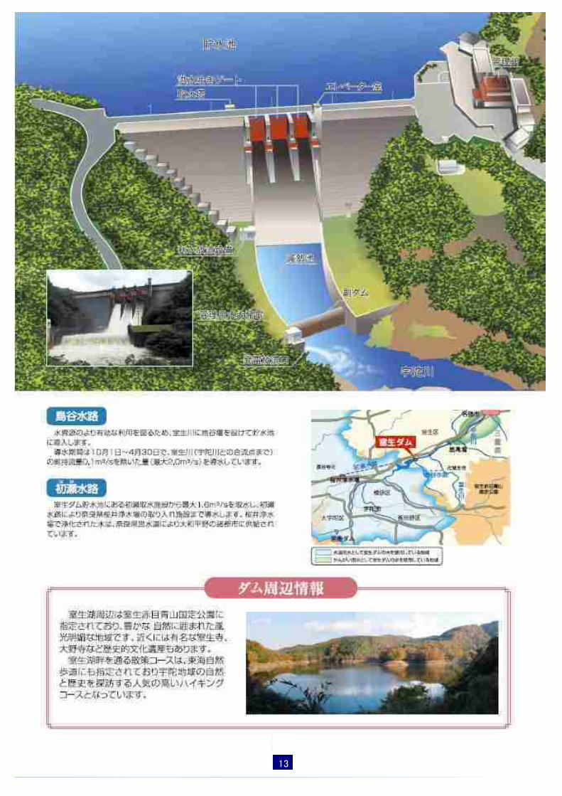
13

●Flood Control (Refer to "Hydrograph of Flood Control Plan) ●Irrigation and Conservation of River Environment -Discharge maintenance flow for river environment including irrigation water ●Domestic Water -Supply domestic water (1.136m3/s) to NARA-city ●Hydro-power for Reservoir Management Generate power for reservoir operation and manintenance works -Max. flow 2.2m3/s
-Effective Head 56.87m -Max. Output 990kW
Hydro-Graph of Flood Control Plan
NUNOME Reservoir
Reservoir area
Hight of Dam Body Lenght of Dam Body Volume of Dam Body
Reservoir Area
Allocation of Reservoir Capacity
Design High Water 460m3/s
Start of Flood Control 100m3/s
Max. Discharge 150m3/s
14
Total Reservoir Capacity
Usage Reservoir Capacity

15

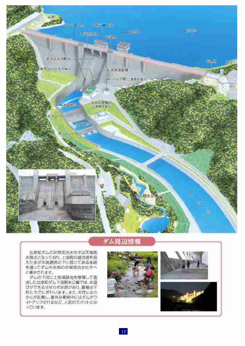
●Flood Control (Refer to "Hydrograph of Flood Control Plan) ●Irrigation and Conservation of River Environment -Discharge maintenance flow for river environment including irrgation water in NABARI area ●Domestic Water -Supply domestic water (1.5m3/s) to NABARI-city,KYOTO prefecture and NARA-city ●Hydro-power 1,800kW (Max 3.7m3.s) managed by MIE Prefecture ●Hydro-power for Reservoir Management Generate power for reservoir operation and manintenance works -Max. flow 0.3m3/s
-Effective Head 38.41m -Max. Output 77kW
Hydro-Graph of Flood Control Plan
HINACHI Reservoir
Inflow
Discharge
Reservoir area
Hight of Dam Body Lenght of Dam Body
Volume of Dam Body Reservoir Area
Total Reservoir Capacity
Usage Reservoir Capacity
Allocation of Reservoir Capacity
16
17