kirby conservation area appraisal and … and building/built... · the legislation (t&cp act...
TRANSCRIPT

WEST KIRBY CONSERVATION AREA APPRAISAL & MANAGEMENT PLAN
Donald Insall Associates Ltd Page 1 of 23
WEST KIRBY CONSERVATION AREA APPRAISAL AND MANAGEMENT PLAN
APPENDICES Prepared for Wirral Council by Donald Insall Associates Ltd, 2007 – Wirral 2009
DONALD INSALL ASSOCIATES LTD, Bridgegate House, 5 Bridge Place, Chester, CH1 1SA Tel: 01244 350063 email: [email protected] web: www.insall-lon.co.uk

WEST KIRBY CONSERVATION AREA APPRAISAL & MANAGEMENT PLAN
Donald Insall Associates Ltd Page 2 of 23
CONTENTS APPENDICES Appendix A - Plan Showing Existing Boundary and Listed Buildings Appendix B - Plan Showing Relative Ages of Buildings Appendix C - Plan Showing Contribution of Buildings to Character of Area Appendix D - Historic Plans Appendix E - Building Descriptions

WEST KIRBY CONSERVATION AREA APPRAISAL & MANAGEMENT PLAN
Donald Insall Associates Ltd Page 3 of 23
WEST KIRBY CONSERVATION AREA APPRAISAL AND MANAGEMENT PLAN
APPENDIX A - PLAN SHOWING EXISTING BOUNDARY AND LISTED BUILDINGS
Donald Insall Associates Ltd, 2007 – Wirral Council 2009
TThhiiss mmaapp iiss bbaasseedd uuppoonn OOrrddnnaannccee SSuurrvveeyy mmaatteerriiaall wwii tthh tthhee ppeerrmmiissssiioonn ooff OOrrddnnaannccee SSuurrvveeyy oonn bbeehhaall ff ooff tthhee CCoonnttrrooll lleerr ooff HHeerr MMaajjeessttyy’’ss SSttaatt iioonneerryy OOffff iiccee ©© CCrroowwnn
ccooppyyrriigghhtt .. UUnnaauutthhoorriisseedd rreepprroodduucctt iioonn iinnffrr iinnggeess CCrroowwnn ccooppyyrriigghhtt aanndd mmaayy lleeaadd ttoo pprroosseeccuutt iioonn oorr cciivv ii ll pprroocceeeeddiinnggss.. ((LLiicceennccee nnuummbbeerr 110000001199880033)) ((PPuubbll iisshheedd 22000099))..
WEST KIRBY CONSERVATION AREA APPRAISAL & MANAGEMENT PLAN
Donald Insall Associates Ltd Page 4 of 23
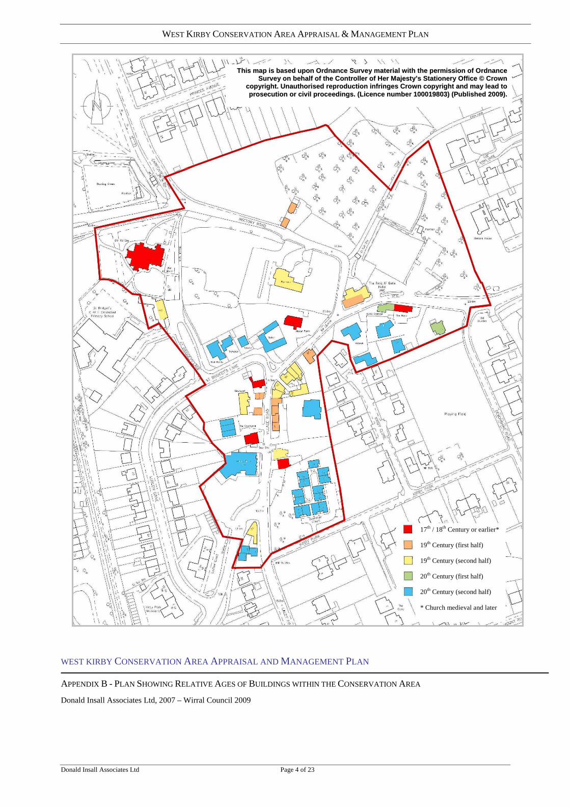
WEST KIRBY CONSERVATION AREA APPRAISAL AND MANAGEMENT PLAN
APPENDIX B - PLAN SHOWING RELATIVE AGES OF BUILDINGS WITHIN THE CONSERVATION AREA
Donald Insall Associates Ltd, 2007 – Wirral Council 2009
17th / 18th Century or earlier* 19th Century (first half) 19th Century (second half) 20th Century (first half) 20th Century (second half) * Church medieval and later
TThhiiss mmaapp iiss bbaasseedd uuppoonn OOrrddnnaannccee SSuurrvveeyy mmaatteerriiaall wwii tthh tthhee ppeerrmmiissssiioonn ooff OOrrddnnaannccee SSuurrvveeyy oonn bbeehhaall ff ooff tthhee CCoonnttrrooll lleerr ooff HHeerr MMaajjeessttyy’’ss SSttaatt iioonneerryy OOffff iiccee ©© CCrroowwnn
ccooppyyrriigghhtt .. UUnnaauutthhoorriisseedd rreepprroodduucctt iioonn iinnffrr iinnggeess CCrroowwnn ccooppyyrriigghhtt aanndd mmaayy lleeaadd ttoo pprroosseeccuutt iioonn oorr cciivv ii ll pprroocceeeeddiinnggss.. ((LLiicceennccee nnuummbbeerr 110000001199880033)) ((PPuubbll iisshheedd 22000099))..

WEST KIRBY CONSERVATION AREA APPRAISAL & MANAGEMENT PLAN
Donald Insall Associates Ltd Page 5 of 23
WEST KIRBY CONSERVATION AREA APPRAISAL AND MANAGEMENT PLAN
APPENDIX C – PLAN SHOWING CONTRIBUTION OF BUILDINGS TO CHARACTER OF AREA
Donald Insall Associates Ltd, 2007 – Wirral Council 2009
A – Buildings Critical to the Character of the Conservation Area B – Buildings Making a Positive Contribution to the Character of the Conservation Area C – Buildings Making a Neutral Contribution to the Character of the Conservation Area D – Buildings Detrimental to the Character of the Conservation Area
TThhiiss mmaapp iiss bbaasseedd uuppoonn OOrrddnnaannccee SSuurrvveeyy mmaatteerriiaall wwii tthh tthhee ppeerrmmiissssiioonn ooff OOrrddnnaannccee SSuurrvveeyy oonn bbeehhaall ff ooff tthhee CCoonnttrrooll lleerr ooff HHeerr MMaajjeessttyy’’ss SSttaatt iioonneerryy OOffff iiccee ©© CCrroowwnn
ccooppyyrriigghhtt .. UUnnaauutthhoorriisseedd rreepprroodduucctt iioonn iinnffrr iinnggeess CCrroowwnn ccooppyyrriigghhtt aanndd mmaayy lleeaadd ttoo pprroosseeccuutt iioonn oorr cciivv ii ll pprroocceeeeddiinnggss.. ((LLiicceennccee nnuummbbeerr 110000001199880033)) ((PPuubbll iisshheedd 22000099))..

WEST KIRBY CONSERVATION AREA APPRAISAL & MANAGEMENT PLAN
Donald Insall Associates Ltd Page 6 of 23
WEST KIRBY CONSERVATION AREA APPRAISAL AND MANAGEMENT PLAN
APPENDIX D – HISTORIC PLANS – 1844 TITHE MAP
Donald Insall Associates Ltd, 2007 – Wirral Council 2009
WEST KIRBY CONSERVATION AREA APPRAISAL & MANAGEMENT PLAN
Donald Insall Associates Ltd Page 7 of 23
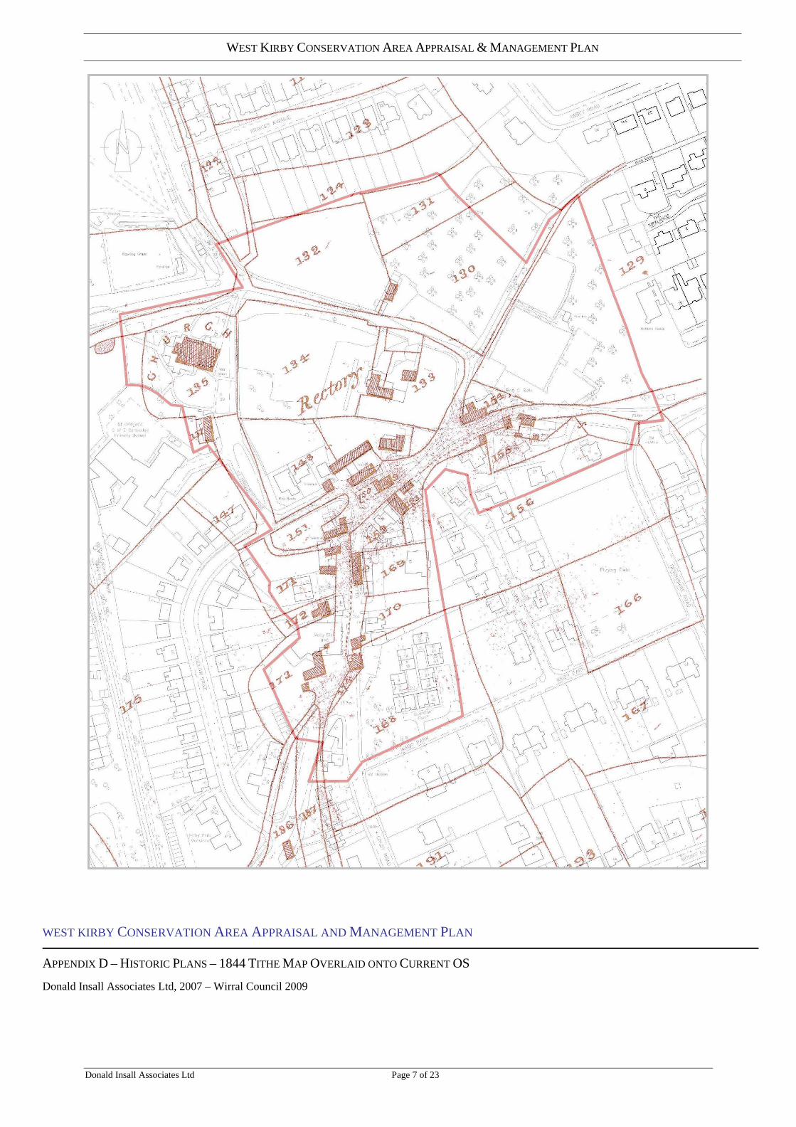
WEST KIRBY CONSERVATION AREA APPRAISAL AND MANAGEMENT PLAN
APPENDIX D – HISTORIC PLANS – 1844 TITHE MAP OVERLAID ONTO CURRENT OS
Donald Insall Associates Ltd, 2007 – Wirral Council 2009

WEST KIRBY CONSERVATION AREA APPRAISAL & MANAGEMENT PLAN
Donald Insall Associates Ltd Page 8 of 23
WEST KIRBY CONSERVATION AREA APPRAISAL AND MANAGEMENT PLAN
APPENDIX D – HISTORIC PLANS – FIRST EDITION OS
Donald Insall Associates Ltd, 2007 – Wirral Council 2009

WEST KIRBY CONSERVATION AREA APPRAISAL & MANAGEMENT PLAN
Donald Insall Associates Ltd Page 9 of 23
WEST KIRBY CONSERVATION AREA APPRAISAL AND MANAGEMENT PLAN
APPENDIX D – HISTORIC PLANS – 1870S OS
Donald Insall Associates Ltd, 2007 – Wirral Council 2009

WEST KIRBY CONSERVATION AREA APPRAISAL & MANAGEMENT PLAN
Donald Insall Associates Ltd Page 10 of 23
WEST KIRBY CONSERVATION AREA APPRAISAL AND MANAGEMENT PLAN
APPENDIX D – HISTORIC PLANS – 1890S OS
Donald Insall Associates Ltd, 2007 – Wirral Council 2009

WEST KIRBY CONSERVATION AREA APPRAISAL & MANAGEMENT PLAN
Donald Insall Associates Ltd Page 11 of 23
WEST KIRBY CONSERVATION AREA APPRAISAL AND MANAGEMENT PLAN
APPENDIX D – HISTORIC PLANS – 1910S OS
Donald Insall Associates Ltd, 2007 – Wirral Council 2009

WEST KIRBY CONSERVATION AREA APPRAISAL & MANAGEMENT PLAN
Donald Insall Associates Ltd Page 12 of 23
WEST KIRBY CONSERVATION AREA APPRAISAL AND MANAGEMENT PLAN
APPENDIX D – HISTORIC PLANS – 1930S OS
Donald Insall Associates Ltd, 2007 – Wirral Council 2009
WEST KIRBY CONSERVATION AREA APPRAISAL & MANAGEMENT PLAN
Donald Insall Associates Ltd Page 13 of 23
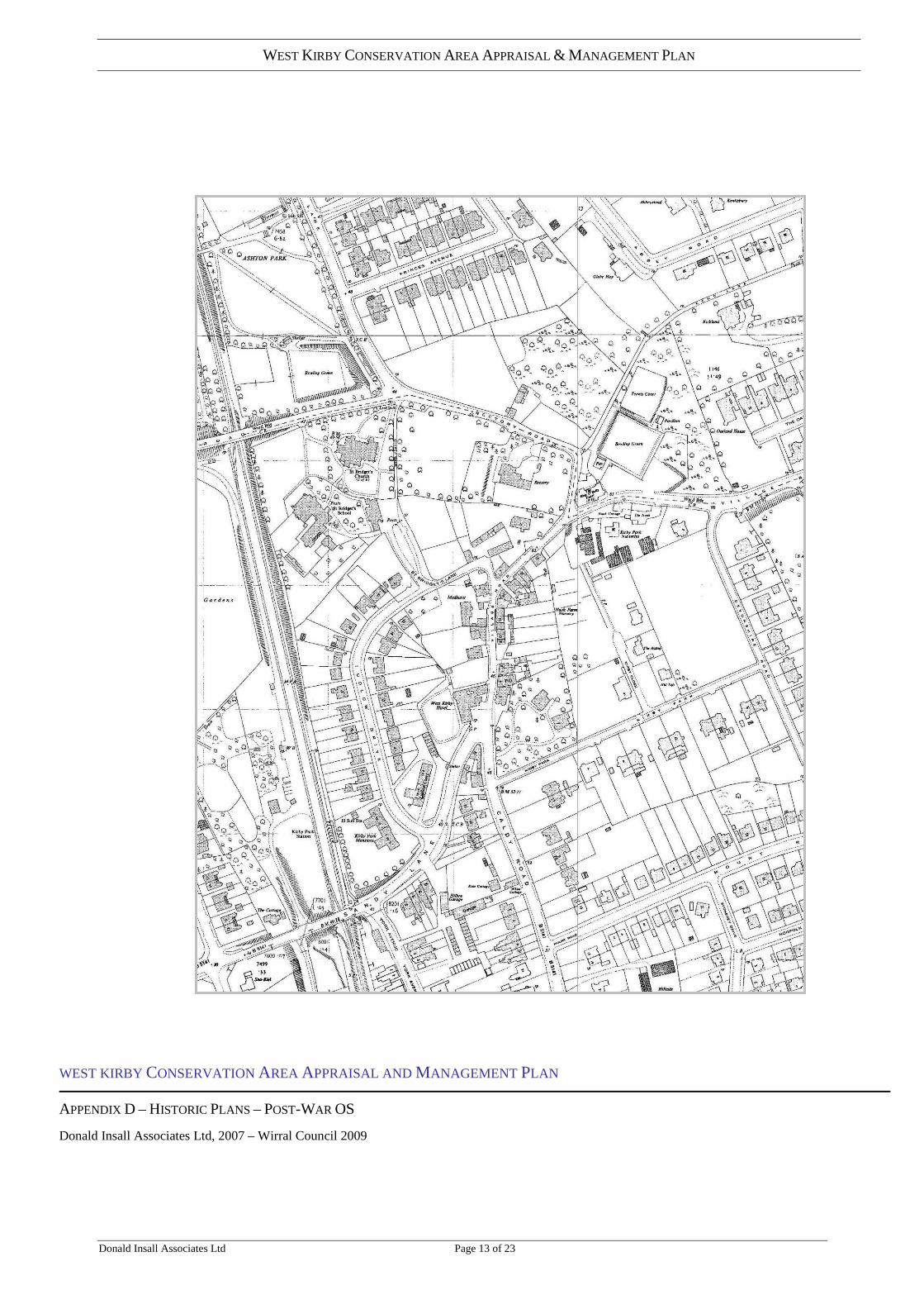
WEST KIRBY CONSERVATION AREA APPRAISAL AND MANAGEMENT PLAN
APPENDIX D – HISTORIC PLANS – POST-WAR OS
Donald Insall Associates Ltd, 2007 – Wirral Council 2009

WEST KIRBY CONSERVATION AREA APPRAISAL & MANAGEMENT PLAN
Donald Insall Associates Ltd Page 14 of 23
APPENDIX E - BUILDING DESCRIPTIONS Notes: The following documents is in the form of a Gazetteer of buildings
within the Conservation Area No/Name: As identified from OS map Wirral UPRN: Space for Wirral Council’s unique referencing system Photograph: Buildings not visible from the public highway or groups
of recent buildings have not been photographed. Description: Brief summary Condition /Comment: All buildings in good condition unless otherwise
noted. Contribution: Buildings are ranked in terms of their contribution to the
character of the conservation area: Refer to appendix C for the coloured plan which illustrates contributions of buildings.
A: (Red) – Buildings that are critical to the character of
the area: typically these may be landmark buildings and / or historic buildings with most of their original character retained.
B: (Yellow) – Buildings that contribute positively to the character of the conservation area: historic buildings may have some alterations but original character is still prominent.
C: (Green) – Neutral - Either modern buildings of little interest or buildings where character has been lost beyond economic redemption.
D: (Blue) – Buildings that detract from the significance or character of the area.
E (No colour) Buildings not visible from a public area or right of way.
Post 1950 buildings and Conservation Character: In assessing the contribution of individual buildings, some difficulties arise in determining the extent to which more recent structures could be said to contribute to area character. The legislation (T&CP Act Listed Buildings and Conservation Areas) is concerned with safeguarding the historic environment. It defines conservation areas as ‘areas of special architectural or historic interest the character or appearance of which it is desirable to preserve or enhance’. PPG 15 advises that our experience of historic areas depends on a variety of factors including on the ‘appropriate scaling and detailing of contemporary buildings’ (4.2). Making judgements on the appropriateness of very recent buildings is often subjective. Their very newness may appear to clash with the historic environment but, over time, this may mellow and once innovative architectural ‘style’ become more generally accepted, even historic. In advance of the ‘test of time’, this appraisal takes a very cautious approach and ranks virtually all very recent
WEST KIRBY CONSERVATION AREA APPRAISAL & MANAGEMENT PLAN
Donald Insall Associates Ltd Page 15 of 23
buildings as neutral (other than those obviously of very poor design). The term ‘recent’ is applied to buildings post 1948. The status of ‘neutral’ buildings will, therefore, require periodic review. (1948 is a ‘cut off’ date referred to in the Act in relation to curtilage structures deemed to be Listed by association with the main building.)
Dating of buildings and sources: In undertaking this conservation area appraisal, age has been estimated on the basis of visual inspections from public areas only, map evidence (1844 Tithe map, OS maps from decades: 1870,1890,1930 and 1950s) and publications: The Hundred of Wirral, P Sulley, The History of Wirral, SJ Roberts and Wirral and its Viking Heritage, P Cavill, S Harding, J Jesch). Many buildings have been altered considerably over time and would require detailed study to fully interpret. The dates provided in the gazetteer, unless otherwise stated are approximate and relate to the original phase of construction or if that cannot be determined the most prominent parts. Unless clear documentary evidence is referred to, the periods ascribed to buildings should not be regarded as definitive. Where the original period of construction has been estimated, fabric from earlier various periods may exist. This is particularly true of vernacular buildings in ancient settlements where building facades can have been successively remodelled and roofs changed from thatch (universal before the later C18) to slate. Date stones cannot always be relied upon as they could have been incorporated into substantial rebuilding.

WEST KIRBY CONSERVATION AREA APPRAISAL & MANAGEMENT PLAN
Donald Insall Associates Ltd Page 16 of 23
NO. / NAME WIRRAL UPRN PHOTOGRAPH DESCRIPTION CONDITION / COMMENT CONTRIBUTION
Caldy Road
2, 2A, 2B
Recently constructed 3 storey ‘town houses’. Part brick part rendered elevations with brick string courses.
Designed with feature and materials reflecting the immediately adjacent C19 property of 72 Sandy Lane.
C
Sandy Lane 72
3 storey, late C19 shop with residential above. Constructed on a narrow corner site the development has ‘frontage’ elevations to end and two sides. Red tilled roof with timber framed gables to four sides. Upper storeys are white rendered with red pressed brick string courses, quoins and window architraves. Ground floor has retained its full height small pane shop front with low stall riser.
An architecturally interesting building in a prominent location providing a visual termination to Village Road.
A
Village Road Guardian Court
Sheltered housing development, 3rd quarter C20. 2 storey linked units, mono pitched roofs, red brick with white concrete panel fronted balconies.
Buildings are set back in wooded plot above Village Road. Not intrusive on conservation area. Good example of development type and period.
C
Moby Dick
Public house constructed approx. 1960s, 2 storey frontage to Village Road. Red sandstone side gable with incised image of whale, single storey to rear.
The 1844 Tithe map shows the site occupied by a ‘cottage and garden’ The Moby Dick replaced the West Kirby Hotel which had been constructed in the late C19. At the time of the Tithe map this was still the site of a ‘cottage and garden’ Car park is visually prominent at junction of Village/Caldy Road and Sandy Lane
C
WEST KIRBY CONSERVATION AREA APPRAISAL & MANAGEMENT PLAN
Donald Insall Associates Ltd Page 17 of 23
NO. / NAME WIRRAL UPRN PHOTOGRAPH DESCRIPTION CONDITION / COMMENT CONTRIBUTION
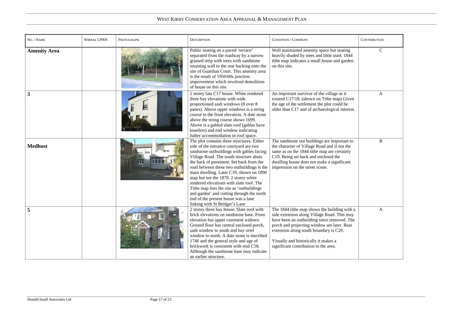
Amenity Area
Public seating on a paved ‘terrace’ separated from the roadway by a narrow grassed strip with trees with sandstone retaining wall to the rear backing onto the site of Guardian Court. This amenity area is the result of 1950/60s junction improvement which involved demolition of house on this site.
Well maintained amenity space but seating heavily shaded by trees and little used. 1844 tithe map indicates a small house and garden on this site.
C
3
2 storey late C17 house. White rendered three bay elevations with wide proportioned sash windows (8 over 8 panes). Above upper windows is a string course to the front elevation. A date stone above the string course shows 1699. Above is a gabled slate roof (gables have kneelers) and end window indicating futher accommodation in roof space.
An important survivor of the village as it existed C17/18. (shown on Tithe map) Given the age of the settlement the plot could be older than C17 and of archaeological interest.
A
Medhust
The plot contains three structures. Either side of the entrance courtyard are two sandstone outbuildings with gables facing Village Road. The south structure abuts the back of pavement. Set back from the road between these two outbuildings is the main dwelling. Later C19, shown on 1890 map but not the 1870. 2 storey white rendered elevations with slate roof. The Tithe map lists the site as ‘outbuildings and garden’ and cutting through the north end of the present house was a lane linking with St Bridget’s Lane
The sandstone out buildings are important to the character of Village Road and if not the same as on the 1844 tithe map are certainly C19. Being set back and enclosed the dwelling house does not make a significant impression on the street scene.
B
5
2 storey three bay house. Slate roof with brick elevations on sandstone base. Front elevation has upper casement widows. Ground floor has central enclosed porch, sash window to south and bay oriel window to north. A date stone is inscribed 1746 and the general style and age of brickwork is consistent with mid C18. Although the sandstone base may indicate an earlier structure.
The 1844 tithe map shows the building with a side extension along Village Road. This may have been an outbuilding since removed. The porch and projecting window are later. Rear extension along south boundary is C20. Visually and historically it makes a significant contribution to the area.
A

WEST KIRBY CONSERVATION AREA APPRAISAL & MANAGEMENT PLAN
Donald Insall Associates Ltd Page 18 of 23
NO. / NAME WIRRAL UPRN PHOTOGRAPH DESCRIPTION CONDITION / COMMENT CONTRIBUTION
11 Manor Farm
2 storey three bay house with gables (and kneelers) slate roof and dormers. White rendered elevations. Lintel above porch has date inscribed 1644. The lintel has a smooth face and is unlikely to be original. However, the buildings general proportions and wide casement widows (not C18 sashes) are consistent with C17 period.
House shown on 1844 map. Set behind a sandstone garden wall this mid C17 house makes as significant visual and historical contribution to the area.
A
Ring’o Bells
From west (above), from east (below)
2 storey public house with ground floor elevations of white painted sandstone and upper storey mock half timbered below gabled slate roof. The present building probably represents two construction phases. 2 storey entrance elevation facing the car park and mock timber framed upper storey is late C19 (c1880s) with the section from Rectory Road to the ‘set back’ on Village Road being C19 building (see note). The car park and children’s play area replaced ‘pub garden’, bowling greens and adjoining woodland in the 1980s.
[Note: Recorded in 1889 (P Sully, H of W) that the building replaced a public house of the same name burnt down in 1810. However, the 1890 OS shows a larger structure than on the 1844 tithe map. The lower portion of the Village Road facade fits with the earlier plan so it can be assumed that this dates from 1810.] Internally, the old plan form has been lost with rooms joined to create a single space. Located on a bend and at the junction with Rectory Road this is a prominent building of visual and historic interest.
A
4
3 Storey house, white rendered upper storeys with small sash windows to left and wide casements to right below gabled roof with dormers. Ground floor frontage has recently constructed projecting garage and porch extension in stone.
The original building is probably C18 and the same as shown on the 1844 plan) but very much altered. Recent dormers and not to a traditional design and window openings appear altered. Although the front extension has compromised the historic elevation it is in good quality materials. Despite the changes the building as a whole still contributes to the character of the village.
B
6/8
2 Storey double gabled four bay frontage to Village Road. Slate roof with white rendered elevations with modern four pane sliding sash windows. Until recently the right hand half of the ground floor accommodated a shop/post office.
Not shown on the 1844 tithe map but from its style and form may date from mid C19. Externally in good condition. It contributes to the character of the village.
B
WEST KIRBY CONSERVATION AREA APPRAISAL & MANAGEMENT PLAN
Donald Insall Associates Ltd Page 19 of 23
NO. / NAME WIRRAL UPRN PHOTOGRAPH DESCRIPTION CONDITION / COMMENT CONTRIBUTION
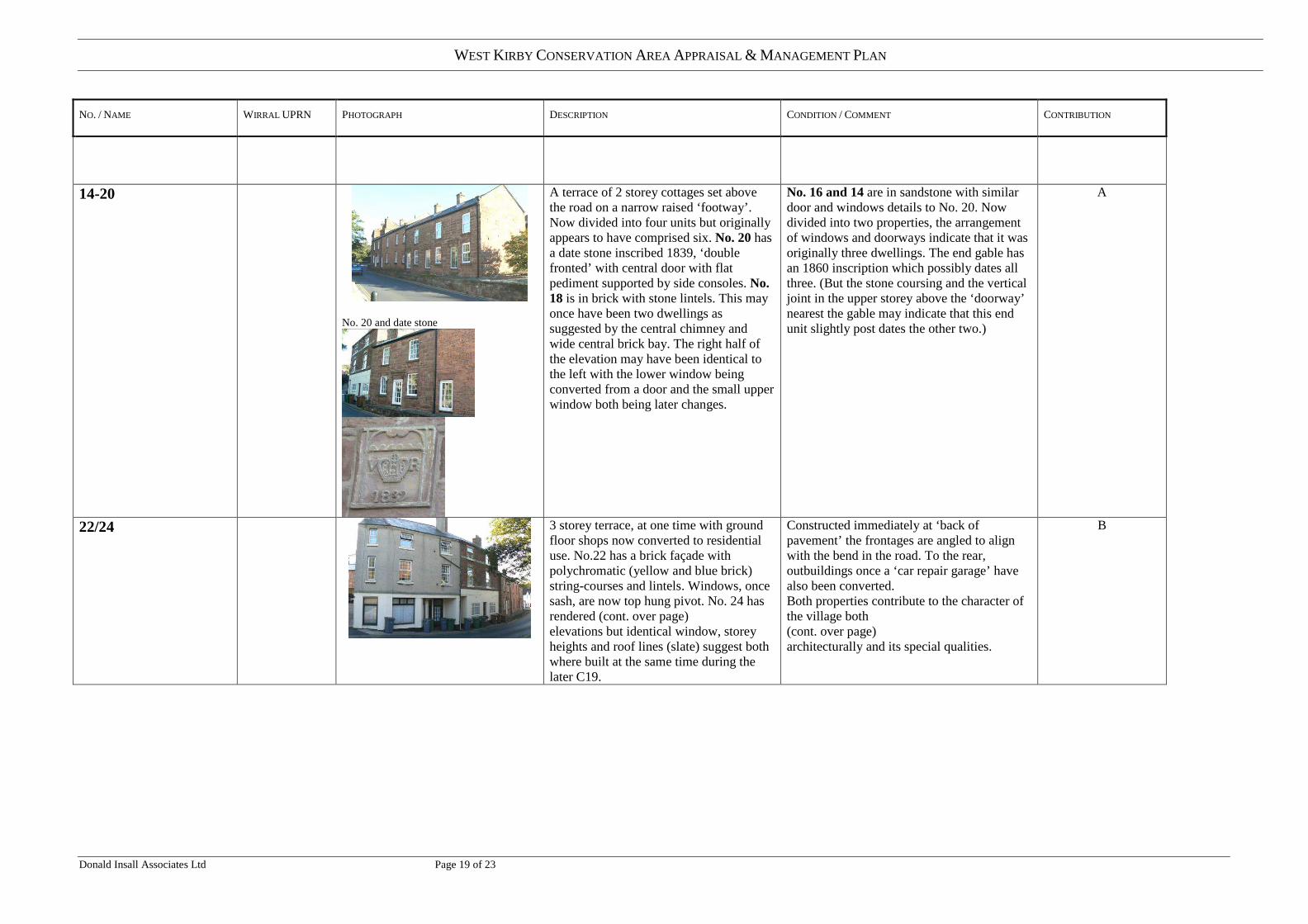
14-20
No. 20 and date stone
A terrace of 2 storey cottages set above the road on a narrow raised ‘footway’. Now divided into four units but originally appears to have comprised six. No. 20 has a date stone inscribed 1839, ‘double fronted’ with central door with flat pediment supported by side consoles. No. 18 is in brick with stone lintels. This may once have been two dwellings as suggested by the central chimney and wide central brick bay. The right half of the elevation may have been identical to the left with the lower window being converted from a door and the small upper window both being later changes.
No. 16 and 14 are in sandstone with similar door and windows details to No. 20. Now divided into two properties, the arrangement of windows and doorways indicate that it was originally three dwellings. The end gable has an 1860 inscription which possibly dates all three. (But the stone coursing and the vertical joint in the upper storey above the ‘doorway’ nearest the gable may indicate that this end unit slightly post dates the other two.)
A
22/24
3 storey terrace, at one time with ground floor shops now converted to residential use. No.22 has a brick façade with polychromatic (yellow and blue brick) string-courses and lintels. Windows, once sash, are now top hung pivot. No. 24 has rendered (cont. over page) elevations but identical window, storey heights and roof lines (slate) suggest both where built at the same time during the later C19.
Constructed immediately at ‘back of pavement’ the frontages are angled to align with the bend in the road. To the rear, outbuildings once a ‘car repair garage’ have also been converted. Both properties contribute to the character of the village both (cont. over page) architecturally and its special qualities.
B

WEST KIRBY CONSERVATION AREA APPRAISAL & MANAGEMENT PLAN
Donald Insall Associates Ltd Page 20 of 23
NO. / NAME WIRRAL UPRN PHOTOGRAPH DESCRIPTION CONDITION / COMMENT CONTRIBUTION
26/28/30
Linked 2 storey dwellings with further storey in roof space. Late C19 ‘Cheshire Tudor’ style, ‘half timbered’ effect upper storeys with projecting gables and 1st floor bay windows. The ground floor appears to have been originally designed as shop units below a part projecting upper storey.
The shop fronts have recently been infilled with sandstone masonry and projecting bays as part of a residential conversion. The two storey building at the rear, former garage workshop, forms part of the conversion with open parking below and living accommodation above The group forms an interesting architectural composition and makes a positive contribution to the character of the area (which has not been unduly compromised by the recent renovation.)
B
32
2 storey sandstone cottage with slate roof, mid C19 or earlier in appearance but not indicated on the 1844 map. An extension has been constructed to the rear with flat roof and rendered elevation.
Recently renovated, the property contributes to the character of the village.
A
Nook Cottage
2 storey dwelling with staggered frontage to Village Road. White washed brick elevations with square casement windows below slate roofs. Appears to incorporate the right hand bay of the adjacent single storey cottage, the Nook.
Brick structure appears 20th century but may contain older fabric. Its plain whitewashed walls and simple windows have been designed in sympathy with and do not detract form the much older adjacent cottage. Listed Grade II as part of the The Nook
A
The Nook
Single storey cottage with thatch roof whitewashed sandstone walls and square casement windows. Constructed on exposed sandstone bedrock. The 1890 map shows a row of six linked structures. The right hand three are assumed to be the present Nook, with Nook Cottage having been reconstructed to the left. Listed Grade II
A fine example of a humble cottage building probably from the early 17th century.
1890
Present day
A

WEST KIRBY CONSERVATION AREA APPRAISAL & MANAGEMENT PLAN
Donald Insall Associates Ltd Page 21 of 23
NO. / NAME WIRRAL UPRN PHOTOGRAPH DESCRIPTION CONDITION / COMMENT CONTRIBUTION
Mobruk and Nos. 40 and 42
Three late C.20 houses constructed on an elevated site set back above Village Road. Mobruck is a substantial property with red tiled roof and extensive areas of glazing. It is partly visible from Village Road up its steeply rising drive. Nos. 40& 42 are hidden behind the Nook and Nook Cottage.
Nos 40 & 42 are well hidden from Village Road. While the design of these properties does not reflect the characteristics of the historic village their impact on the conservation area as a whole is limited by their relative concealment. However, their construction has changed the previously more open rear setting of the ‘Listed’ Nook and Nook Cottage.
C
Kirby Close
12 Not Photographed Recent property on elevated site off Kirby Close.
Cannot be viewed from Village Road and has minimal impact on the Conservation Area
C
Rectory Road
The Rectory,
Rectory grounds viewed from Rectory Road (above) and Church Walk (below)
Substantial two storey house, still the Parish rectory, dating from C19 with possible C18 fabric. Only glimpse views from public highway, not possible to photograph or inspect. West elevation has rendered 1st floor with wide timber mullioned windows projecting over stone lower storey.
Set within grounds with heavily wooded boundary. Cannot be viewed from Rectory Road but is important to the history of the Conservation Area but important in being an historic site associated with the church.
B
Storage Building North Side
Two former agricultural storage buildings in sandstone with slate roofs one has a side gable abutting Rectory Road.
Contribute to the semi-rural character of this part of the conservation area. Both appear to date from the 19th century. The rear barn may be earlier and is shown on the 1844 plan. Condition: These structures appear in poor condition and could be under threat.
A

WEST KIRBY CONSERVATION AREA APPRAISAL & MANAGEMENT PLAN
Donald Insall Associates Ltd Page 22 of 23
NO. / NAME WIRRAL UPRN PHOTOGRAPH DESCRIPTION CONDITION / COMMENT CONTRIBUTION
St Bridget’s Lane / Church Walk
St Bridget’s Church
Red sandstone, tower with battlements, chancel, north and south isles in ‘decorated’ and ‘perpendicular’ styles and with half timbered C19 ‘Tudor’ porches. A church has existed on thissite since before the Norman Conquest. (cont. next page) The majority of the present construction dates from 1869, being a Victorian interpretation (or ‘restoration’) of what was thought to have existed prior to alterations undertaken at the end of the C18. Some C14 fabric is reported to survive notably in the chancel and its east window. Piscine (priests washing basin) and sedilia (seats for clergy) built into stonework. Some later medieval fabric also survives in the north isle and tower.
During the 1869 construction phase remnants of the foundations of a ‘smaller fabric were seen, presumably the original Saxon church and the bases of two Norman columns were uncovered by the tower’ (Sully). Also found were (cont. next page) Saxon stone crosses and a Viking ‘hog back’ tomb stone from the C10/11. During this period there was an influx of Viking peoples who resettled to the Wirral peninsular from Ireland. The dedication of the church to St Bridget, an Irish saint, must date from this time. It is possible that the site is even older, the name of ‘Kirkby’ in Norse referring to a ‘settlement with a church’ and which could imply that both existed prior to the Viking influx.
A
St Bridget’s School
School house, later C19, in ‘late medieval ’style with red sandstone elevations and stone mullioned windows, below slate roof.
The present building replaces the Sunday school built in 1825 and shown on the 1844 map. The old school house adds to the character of the conservation area and to the setting of the church.
A
3 separate properties
� Red Roofs,
� Trevenan,
� Cawdy,
Cawdey
Three later C20 (approx.1960s) detached houses in varied styles, suburban in character. Red roofs is single storey. Trevenan is 2 storey, white rendered facades below gabled roof. Cawdey is 2 storey with hipped roof.
Individual properties which stylistically relate more to the C20 suburban character of Ludlow Drive than the Old Village conservation area.
C

WEST KIRBY CONSERVATION AREA APPRAISAL & MANAGEMENT PLAN
Donald Insall Associates Ltd Page 23 of 23
NO. / NAME WIRRAL UPRN PHOTOGRAPH DESCRIPTION CONDITION / COMMENT CONTRIBUTION
Red Roofs and Trevenan from viewed north across school playing fields
Sator
Later C20 individually designed dwelling comprising linked single storey sandstone structures. These may well incorportate parts of the masonry of two agricultural buildings shown on the 1844 Tithe map which appear to have been associated with Manor Farm. The name Sator is the field name indicated in the Tithe register. The current building plan matches the 1844 layout.
An example of old structures being retained for residential use with later C20 ‘modern’ interventions.
B