king county parks fitness...
TRANSCRIPT

1
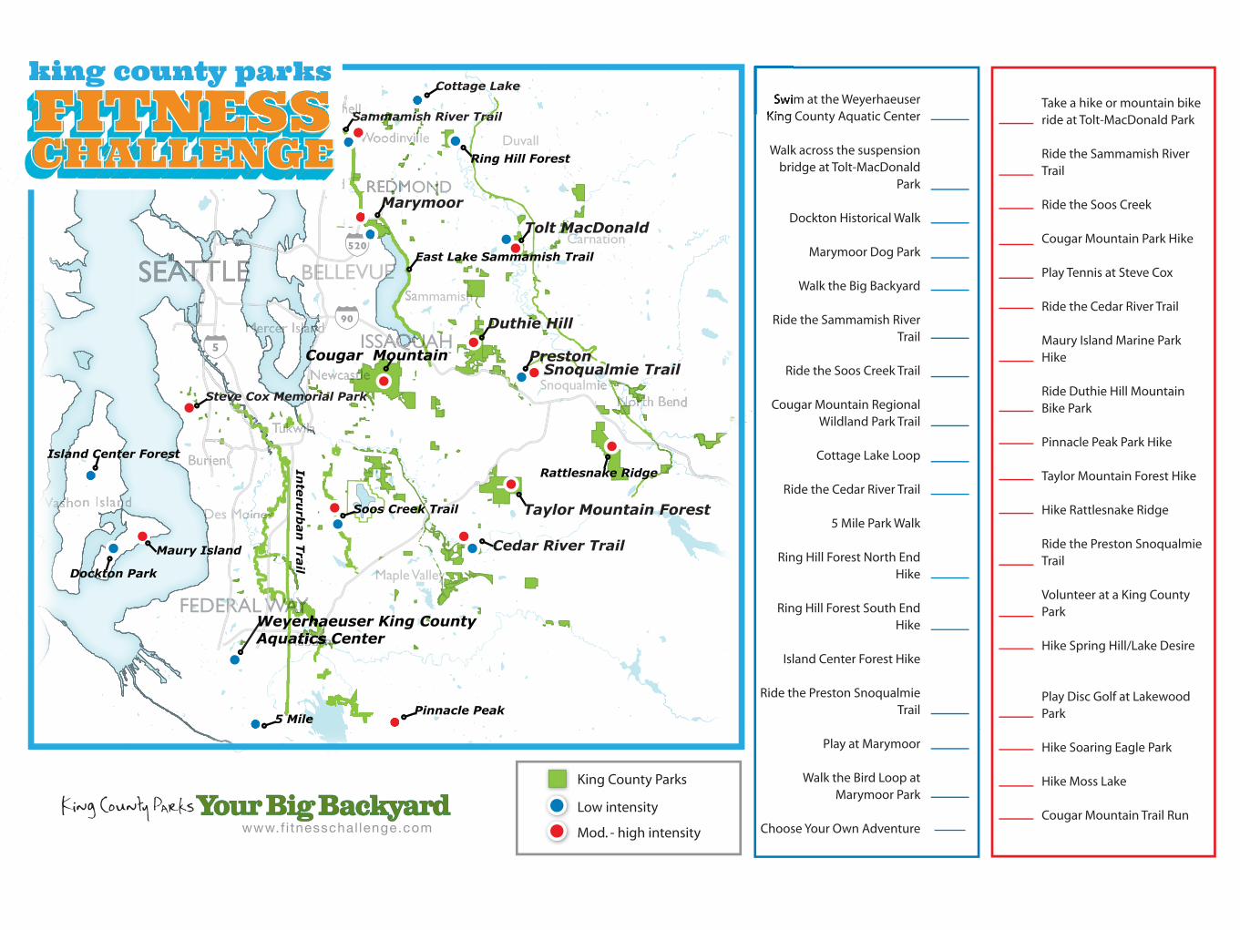
King County Parks Fitness Challenge Challenge Activity List
2/14/14
LOW INTENSITY ACTIVITES
ACTIVITY NAME ACTIVITY DESCRIPTION ADDRESS/URL
Swim at the Weyerhaeuser King County Aquatic Center
Bring your swimsuits and the entire family. Hours of operation are: Mon – Fri: 6:00 AM – 8:00 PM. Sat and Sun: 11:30 AM – 1:30 PM. Public swim times vary. There is a fee for participation.
http://www.kingcounty.gov/recreation/parks/pools.aspx 650 SW Campus Drive Federal Way,
WA 98023
Walk Across the Suspension Bridge at Tolt-MacDonald Park
Enjoy the terrific view so the Snoqualmie River and the Cascade Foothills as you walk across the 500 foot long suspension footbridge. From the main parking lot walk toward the camping area. Entrance to the bridge is near the campground.
http://www.kingcounty.gov/recreation/parks/inventory/toltmacdonald.aspx Northeast 40th Street Carnation, WA
*We do have a map for this site located
on the above landing page Dockton Park Historical Walk
Take a step back in time with this .5 mile historical interpretive stroll that includes one mild hill. Ten interpretive signs though old neighborhoods and along the road detail the history of the Dockton shipbuilding days during the early 1900’s. A portion of this walk is along the
Dockton Park 9500 SW Dock St, Vashon 98070

2
shoulder of a residential road. After the historical trail, walk down to the dock and see how many starfish you can find! Dockton Park includes restrooms, play area, and a picnic shelter. From the Ferry, follow Vashon Highway S. Left at SW 204th St. Follow road straight as it turns into Ellisport. Follow the curve right as it turns into Dockton Road SW. Veer right to stay on Dockton Road SW. Turn Right into Dockton Park.
Marymoor Park Off-Leash Dog Area
This 40 acre off-leash dog park has it all for your four legged friend. There are three river access points, miles of trails, beautiful views and after a muddy day at the dog park, you can clean your furry friend at the Wash Spot located in Parking lot D. Enter the park and follow signs to Parking Lot G. There is a $1 fee for parking. There is a major event evenings and weekends at Marymoor Park through April 13th that will impact parking and traffic.
http://www.kingcounty.gov/recreation/parks/inventory/marymoor.aspx 6046 W Lake Sammamish Parkway NE
Walk the Big Backyard 5k to Benefit King County Parks
Enter to walk the Big Backyard 5k Presented by Group health at www.bby5k.com on June 1, 2014. This family and dog friendly event does have a fee for participation and all proceeds benefit King County Parks.
www.bby5k.com – Find out more details and register
Ride the Marymoor Take an approximately eight mile bike ride (round trip) http://www.kingcounty.gov/recreation/p

3
Connector and Sammamish River Trails
along the paved Sammamish River Trail with some scenic views of rivers, mountains and valleys. Start at the Velodrome and follow the Marymoor Connector trail West toward Bellevue and connect onto the Sammamish River Trial. The midpoint is near Sixty Acres Park. There are restrooms and benches at the beginning and end of the trail. This challenge starts at the Velodrome at Marymoor Park. Enter the park and follow signs to Parking Lot I. There is a $1 fee for parking. There is a major event evenings and weekends at Marymoor Park through April 13th that will impact parking and traffic.
arks/trails/regionaltrailssystem/sammamishriver.aspx 6046 W Lake Sammamish Parkway NE *Address is same as Marymoor Park since that is where people can park
Ride the Soos Creek Trail
Enjoy an approximately five mile bike ride (round trip) along the Soos Creek Trail through woods, meadows and wetlands. This is a paved trail that does have some incline/decline. Look for the code word around mile 2.5. Restrooms are located at the start point and there are benches along the route.
http://www.kingcounty.gov/recreation/parks/trails/regionaltrailssystem/sooscreek.aspx SE 266th Street & 148th Ave SE
Cougar Mountain Regional Wildland Park and Trail Hike
Enjoy this lovely hike up to Coal Creek Falls. The falls are at their most impressive after a rainy downpour. Head up the Red Town trail to the Cave Hole trail junction (approx. 200’) and turn left up Cave Hole. A steady, but gentle, incline for .4 mile will bring you to the Coal Creek Falls trail. Walk .7 miles to the Falls and bridge crossing. You have arrived at
http://www.kingcounty.gov/recreation/parks/inventory/cougar.aspx Red Town Trailhead – Lakemont Blvd SE & NewCastle Golf Club Road, Bellevue, 98006

4
your destination. From I-90, take exit 13 and drive south on Lakemont Boulevard SE for 3.1 miles. Look for the entrance to the Red Town Trailhead on the left side of the road. Sanicans are located at the Red Town Trailhead.
*There are directions to the trailhead on the webpage. There is also a trail map link on the page
Cottage Lake Loop This approximately ½ mile paved loop takes you around beautiful Cottage Lake Park. Cottage lake Park has parking located directly off of NE Woodinville-Duvall Road. Pull into the main parking lot and walk to Cottage Lake Dock to start your walk.
http://www.kingcounty.gov/recreation/parks/inventory/cottagelake.aspx E Woodinville-Duvall Rd and 188th NE
Ride the Cedar River Trail
The Cedar River Trail is a paved, off-road trail. Travel North West along the trail (toward Renton) for a scenic 5 mile round trip ride. The half-way point is around the intersection of Cedar Grove Road. Travel East along Highway 169. The Gravel Parking lot will be on the left right before crossing under highway 18. There are no restrooms along this length of the trail.
http://www.kingcounty.gov/recreation/parks/trails/regionaltrailssystem/cedarriver.aspx Highway 18 and Maple Valley Road Gravel Lot
Five Mile Park Walk From the parking lot head toward shelter 1 and you will see the gravel path along the way. There is a ½ mile, ADA pathway that takes you around the park. Five Mile Park also has a play area, picnic shelters, basketball and tennis courts and open fields.
36541 Military Road S. near S. 368th Street Between Algona, Federal Way and Edgewood

5
Ring Hill Forest North End Hike
Travel East along NE Woodinville Duvall Road. Enjoy a 3.2 mile hike though one of King County’s long-standing working forest sites. Follow the service road down to the trail loop sign on your right and continue down the trail until you approach the code word sign. If you’d like to continue your hike from the code word sign, cross the service road and follow the loop trail. There are no restrooms on site. Turn right on NE Old Woodinville Duvall Road which will become Meyers Road/232nd Ave NE. Continue South and look for the trailhead and small dirt parking lot on your left. Parking is limited to 3 vehicles.
http://your.kingcounty.gov/ftp/gis/Web/VMC/recreation/BCT_RingHill_brochure.pdf 232nd Avenue NE, Woodinville, WA 98072 *We have a series of backcountry maps located here: http://www.kingcounty.gov/operations/GIS/Maps/VMC/Recreation.aspx#RI
Ring Hill Forest South End Hike
This gravel, gently graded trail is 5/8 mile round trip loop that travels through a working forest site. Travel East along NE Woodinville Duvall Road and turn right on NE Old Woodinville Duvall Road. NE Old Woodinville Duvall Road will become Meyers Road/232nd Ave NE. Continue South on Meyers road/232nd Ave NE and turn left onto NE 147th Street. The road will end at the trailhead.
232nd Avenue NE, Woodinville, WA 98072 http://your.kingcounty.gov/ftp/gis/Web/VMC/recreation/BCT_RingHill_brochure.pdf *We have a series of backcountry maps located here: http://www.kingcounty.gov/operations/GIS/Maps/VMC/Recreation.aspx#RI
Island Center Forest This site is appropriate for hiking or mountain biking. This http://www.kingcounty.gov/recreation/p

6
Hike beautiful forested trail is flat and well maintained. Follow the main trail. At the first sign turn right and follow the Land Trust Trail. The trail endpoint is at the other end of the clearing. This hike is approximately 1.24 miles. Follow Vashon highway S. Turn Right on SW 188th St. Turn right into the parking lot.
arks/trails/backcountry/islandcenterforest.aspx 17760 115th Ave SW, Vashon 98070
Ride the Preston Snoqualmie Trail
This paved, gently graded, off-road trail is a beautiful 4 mile round trip ride along a historic railroad route. Start at Preston Athletic Fields and Park. The trail is adjacent to the park. Restrooms are available at Preston Athletic Fields and Park.
8625 310th Ave SE Preston WA 98024 *Address is for Preston Athletic Fields and Park. That is where the ride starts.
Play at Marymoor Park
When was the last time you went to the park to play? The outdoor gym equipment at Marymoor Park is like a playground for adults. It consists of five pieces designed to help strengthen arms, legs, core, and aerobic function. The outdoor gym faces a new playground designed for toddlers so you can exercise while your little one plays. Enter the Park and follow signs to Lot K. There is a $1 fee for parking. There is a major event evenings and weekends at Marymoor Park through April 13th that will impact parking and traffic.
http://www.kingcounty.gov/recreation/parks/inventory/marymoor.aspx 6046 W Lake Sammamish Parkway NE

7
Walk the Bird Loop at Marymoor Park
Come see some of the more than 200 bird species that have been observed at Marymoor Park by walking the approximately 2.2 mile Audubon Bird Loop. Start at the Grassy Meadow Trail, along the Footbridge to the Marsh and Forest River Trail, through the River Corridor and finally from the River Kiosk back to the Meadow Kiosk. Part of this bird loop is inside the off-leash dog park so you may encounter dogs off leash during this activity. Enter the Park and follow signs to Parking Lot G. There is a $1 fee for parking. There is a major event evenings and weekends at Marymoor Park through April 13th that will impact parking and traffic.
http://www.kingcounty.gov/recreation/parks/inventory/marymoor.aspx 6046 W Lake Sammamish Parkway NE
Choose Your Own Adventure - Pick Your Own Favorite Park and Go Play!
King County Parks loves our 200 parks, 175 miles of trail and 26,000 acres of open space but we also know that you love your local parks. Take time to go out and enjoy your favorite local park and share your fun on facebook (iheartkcparks).

8
HIGH INTENSITY ACTIVITES ACTIVITY NAME ACTIVITY DESCRIPTION ADDRESS/URL
Take a Hike or Mountain Bike Ride at Tolt-MacDonald Park
Tolt-MacDonald Park offers 12 miles of forested and riverside trails and is a favorite mountain bike destination. To access the trail network from the main parking lot walk toward the camping area, walk across the suspension bridge and continue up the hill towards the cabin. A trail sign will be located near the cabin and you will see a midpoint trail sign at a .25 of a mile.
http://www.kingcounty.gov/recreation/parks/inventory/toltmacdonald.aspx Northeast 40th Street Carnation, WA
*We do have a map for this site located
on the above landing page
Ride the Marymoor Connector and Sammamish River Trail
Take an approximately 22 mile bike ride (round trip) along the paved Sammamish River Trail with some scenic views of rivers, mountains and valleys. Start at the Velodrome and follow the Marymoor Connector trail West toward Bellevue and connect to the Sammamish River Trial. Follow signs to the Burke Gillman Trail. The code word sign is near Log Boom Park. There are restrooms and benches at the beginning and end of the trail. This challenge starts at the Velodrome at Marymoor Park. Enter the park and follow signs to Parking Lot I. There is a $1 fee for parking. There is a major event evenings and weekends at Marymoor Park through April 13th that will impact parking and traffic.
http://www.kingcounty.gov/recreation/parks/trails/regionaltrailssystem/sammamishriver.aspx 6046 W Lake Sammamish Parkway NE *Address is same as Marymoor Park since that is where people can park
Ride the Soos Creek Trail
Enjoy this approximately 10 mile bike ride (round trip) along the Soos Creek Trail through woods, meadows and
http://www.kingcounty.gov/recreation/parks/trails/regionaltrailssystem/sooscree

9
wetlands. This is a paved trail that does have some incline/decline. The trail jogs right at the T junctions and then starts again on the left. Look for the code word sign around mile 5 at Gary Grant Park. Restrooms are located at the start and finish of this ride. There are benches along the route.
k.aspx SE 266th Street & 148th Ave SE
Cougar Mountain Park Hike
From the trailhead go .6 miles up hill to the Wilderness Creek-Wilderness Cliffs junction. Follow the 1.5 mile Wilderness Creek trail to the Wilderness Peak trail. Keep following the trails until you make it to the highest point on Cougar Mountain. That’s an elevation of 1595 feet.
http://www.kingcounty.gov/recreation/parks/inventory/cougar.aspx 10400 Renton Issaquah Road SE,
Renton, WA 98059
Play Tennis at Steve Cox Memorial Park
Bring your own tennis equipment and play like the pros at this newly refurbished tennis court. After the match enjoy some of the other offerings at the park including the reflexology walking path, play area and a picnic shelter.
http://www.kingcounty.gov/recreation/parks/inventory/stevecoxmemorial.aspx 1321 SW 102nd St Seattle WA 98146
Ride the Cedar River Trail
Travel North West along the trail (toward Renton) for a scenic 14 mile round trip ride. The code word is located at one of our Regional Trail Kiosks. There are no restrooms along this length of the trail.
http://www.kingcounty.gov/recreation/parks/trails/regionaltrailssystem/cedarriver.aspx Highway 18 and Maple Valley Road Gravel Lot
Maury Island Marine Park Hike
Enjoy the peace and relaxation of a beautiful beach. Begin at the parking lot and follow the trail down to the waves and sand. The walk back up is a steep hike. Sanicans are available at the bottom of the trail.
http://www.kingcounty.gov/recreation/parks/naturalresources/naturallands/mauryislandmarine.aspx

10
5100 SW 244th St, Vashon 98070
Ride the Boot Camp Cross-Country Trail at Duthie Hill Mountain Bike Park
The lush forest provides an excellent backdrop for a mountain bike park, the result of a partnership with Evergreen Mountain Bike Alliance. Trails are marked green for beginner, blue for moderate, black for most difficult. Bootcamp is a green, beginner, cross-country trail. From the parking lot, bike to the main clearing (about ¼ mile). The kiosk has a trail map and shows where Bootcamp begins. The parking lot is often full. If so, park at Cascade Elementary School.
http://www.kingcounty.gov/recreation/parks/trails/backcountry/duthiehill.aspx 27101 SE Duthie Hill Road, Issaquah 98029
Pinnacle Peak Park Hike
Follow Cal Magnuson trail straight up. This hike is high intensity and will take about 35-45 minutes. From highway 169 turn left onto S 416th Street. Turn right at 284th ave SE. Turn Right at 472nd Street. The trailhead is on the left. There is no formal parking lot but some informal shoulder parking is available.
http://www.kingcounty.gov/recreation/parks/trails/backcountry/pinnaclepeak.aspx SE 276th and 472nd SE, Enumclaw WA 98022
Taylor Mountain Forest Hike
Taylor Mountain is hike, bike and horse friendly. Follow the Holder Ridge Trail to the right to connect with the Holder Knob Trail. Enjoy beautiful forest views. This trial is uphill so expect a workout. The main parking lot is located at the intersection of State route 18 and the Issaquah-Hobart road. Enter the main parking lot and cross the gravel road to get to the Holder Ridge Trail.
http://www.kingcounty.gov/recreation/parks/trails/backcountry/taylor_trails.aspx

11
Hike Rattlesnake Ridge This is a 10 mile hike with a 3,500 foot elevation gain so be prepared. Along the route you will see amazing views. The code word is located past the tree line near the towers. This area is co-owned and managed by the Washington State Department of Natural Resources and you will need a State Parks Discover Pass to park here or pay the State daily fee of $10. Take exit 27 from I-90 east. Turn right at the end of the off ramp and follow the road to the end. Go through the gate on the right to enter the trailhead.
37580 Winery Road, Snoqualmie
Ride the Preston Snoqualmie Trail
This paved, gently graded, mostly off-road trail is a beautiful 14 mile round trip ride with a view of Snoqualmie Falls. At Preston Fall City Road a portion of the trail in on road with a jersey barrier. There are also a few steep switchbacks. Start at Preston Athletic Fields and Park. The trail is adjacent to the park. Restrooms are available at Preston Athletic Fields and Park.
8625 310th Ave SE Preston WA 98024 *Address is for Preston Athletic Fields and Park. That is where the ride starts.
Volunteer at a King County Park!
Volunteer as an individual or as a team. Get some exercise and show your support for King County Parks! Contact Laurie Clinton our Volunteer Coordinator at 206-296-4452.
http://www.kingcounty.gov/recreation/parks/volunteer.aspx
Spring Hill/Lake Desire Park at any location and follow the signs to the Peak trail. http://your.kingcounty.gov/ftp/gis/Web/

12
Follow the Peak trail until you get to the top. Enjoy the view.
VMC/recreation/BCT_SpringLkMcGarvey_brochure.pdf *We have a series of backcountry maps located here: http://www.kingcounty.gov/operations/GIS/Maps/VMC/Recreation.aspx#RI
Play Disc Golf at Lakewood Park
Bring your own disks and enjoy this high intensity activity that takes you throughout the park. Basket 1 is right off the parking lot. If you don't have your own equipment there is a pro shop on site.
11050 10th Ave SW Seattle, WA 98146
Hike Soaring Eagle Park
From the trailhead follow the Pipeline Trail and explore the beauty of Soaring Eagle Park.
http://your.kingcounty.gov/ftp/gis/Web/VMC/recreation/BCT_SoaringEagle_brochure.pdf 26015 East Main Drive Sammamish, WA *We have a series of backcountry maps located here: http://www.kingcounty.gov/operations/GIS/Maps/VMC/Recreation.aspx#RI
Hike Moss Lake Moss Lake is comprised of 372 acres of high-quality wetland and forested upland habitats. An extensive 150-acre wetland complex encompasses a large sphagnum bog and also features beaver dams and includes a 6.5-acre cattail and spirea-
http://your.kingcounty.gov/ftp/gis/Web/VMC/recreation/BCT_MossLake_brochure.pdf 10902 NE Moss Lake Rd Carnation WA

13
fringed lake. Enjoy the 2.9 mile hike as you explore this environmental wonder.
98014 *We have a series of backcountry maps located here: http://www.kingcounty.gov/operations/GIS/Maps/VMC/Recreation.aspx#RI
Join the Cougar Mountain Trail Run!
Participate in the 11th Annual Cougar Mountain Trail Run Series 5k Event on Saturday, July 12, 2014, 9:00 a.m. (5k starts at 9:15am) Just 15 minutes from Seattle, King County's Cougar Mountain Regional Wildland Park, is a trail running paradise thanks to its rolling and runnable hills and trail variety ranging from narrow and technical to wide and groomed. Run through lush forest, fern-lined single-track, over hills and along marshes, just minutes from the city.
http://www.nwtrailruns.com/content/scott
-cougar-mountain-trail-run-series-3