kinematic performance of novatel correct with … · kinematic performance of novatel correct with...
TRANSCRIPT

Kinematic Performance of NovAtel CORRECT with TerraStar-D Precise Point Positioning (PPP)
Service Altti Jokinen, Cameron Ellum, Janet Neumann, David Chan, Iain Webster, Sara Masterson and Thomas Morley
NovAtel Inc., Calgary, AB, Canada
BIOGRAPHY Altti Jokinen is a Geomatics Designer at NovAtel Inc. and PhD student at Centre for Transport Studies (CTS) in the Department of Civil and Environmental Engineering at Imperial College London, UK. His PhD research focus is Precise Point Positioning (PPP). He has seven years of experience on GNSS research and development work. Email: [email protected] Website: http://www.novatel.com/ Cameron Ellum is a Senior Geomatics Designer at NovAtel. Since joining NovAtel in 2006, he has worked on the algorithms and architecture for all of NovAtel’s high precision satellite navigation engines; most notably, PPP and RTK. He received his M.Sc. and Ph.D. degrees in Geomatics Engineering from the University of Calgary in 2002 and 2009, respectively. Janet Brown Neumann is a NovAtel Fellow, working in the Positioning Algorithms Group. She holds an MS and BS in Electrical Engineering from Iowa State University and the University of Kansas, respectively, and has been involved in the design and implementation of GNSS algorithms for the past 31 years. David Chan is a Chief Engineer at NovAtel Inc. in Calgary, Canada. He received his B.Sc in Electrical Engineering from University of Calgary (UofC) in 1996, and his M.Eng in E.E. from UofC in 2006. Iain Webster is Manager of the Core Geomatics group at NovAtel. He holds an M.Sc.E.in Surveying Engineering from the University of Brunswick and has over 20 years of experience in the GNSS receiver industry. Sara Masterson is the New Business Development Manager at NovAtel and specifically responsible for the Correction Services business at NovAtel. She has a BS in Geomatics Engineering and has worked in product management and business development roles at NovAtel since 2003. Thomas Morley is the Manager of the Applied Technology Group at NovAtel in Calgary, Canada. He has over 25 years of experience in the navigation field. He holds an M.Sc. in Geomatics Engineering from the University of Calgary and an ME in Engineering Management from The University of Colorado at Boulder.
ABSTRACT NovAtel CORRECT™ with TerraStar-D enables global real-time PPP services for land and aerial applications using corrections generated by TerraStar. With only a TerraStar-D enabled and subscribed NovAtel OEM6 GNSS receiver and L-band supporting antenna, users can get global centimeter-level positions in real-time. The performance of NovAtel CORRECT with TerraStar-D is tested in this paper using a variety of kinematic and static datasets. Based on the results, TerraStar-D provides position solutions with between 4 and 6 cm horizontal Root Mean Square (RMS) errors. That is sufficient for many practical applications in agriculture, machine control, near-shore surveying and mobile mapping. The NovAtel CORRECT with TerraStar-D performance is compared against solutions derived from several other PPP correction feeds: the openly-available real-time International GNSS Service (IGS) and Centre National d'Études Spatiales (CNES) services, NovAtel’s entry-level PACE service (with corrections provided by Natural Resources Canada), post-processed IGS final products and the commercial OmniSTAR G2 service. Based on the results, TerraStar-D provides significantly better performance than the IGS, CNES and PACE correction services and similar performance compared to OmniSTAR G2 and IGS final post-processed corrections. INTRODUCTION Precise Point Positioning (PPP) can be used to provide global centimeter-level positioning accuracy by employing only one GNSS receiver (Zumberge et al., 1997). There are many applications such as agriculture or surveying which can benefit from PPP, because no local reference receiver or receiver-networks are required as in the case of conventional Real Time Kinematic (RTK) positioning (Remondi, 1984, Counselman and Gourevitch, 1981). This can give significant cost and operational saving for customers and make cm-level positioning possible in areas where it is not practical using RTK. The technical principle of PPP is that measurement errors are mitigated or removed using modeling and correction products such as precise satellite orbit and clock corrections. The products are generated using data from a global reference network and they can be applied anywhere on the Earth. The first order ionosphere effects
are removed by using the ionosphere-free combination of the L1 and L2 measurements and tropospheric delays are mitigated through modeling. NovAtel Inc. has recently released NovAtel CORRECT™ with PPP. It has two levels of real-time services: an entry level, Ntrip-delivered PACE service that uses GPS-only corrections generated by Natural Resources Canada (NRCan), and a higher-end TerraStar-D service that uses corrections generated by TerraStar. The TerraStar-D corrections are provided for both GPS and GLONASS and are broadcast from Inmarsat telecommunication satellites. Thus, users can access the corrections using an L-band capable receiver and antenna without requiring any additional equipment such as a cellular modem or Wi-Fi radio. In this paper, the kinematic performance of the NovAtel CORRECT with TerraStar-D service is demonstrated. Tests are done using kinematic data collected under different conditions, and static data with forced-kinematic processing from a variety of locations. Tests are done in real-time using NovAtel OEM6 receivers. The results show that NovAtel CORRECT with TerraStar-D provides highly-stable kinematic positions with between 4 and 6 cm horizontal RMS error. This is significantly better than the performance of openly available PPP services such as International GNSS Service (IGS) real-time or Centre National d'Études Spatiales (CNES), and is as good or better than competing commercial services. TERRASTAR-D NovAtel CORRECT with TerraStar-D (http://www.terrastar.net/) is a premium, L-band-delivered PPP service. TerraStar-D is built upon GPS and GLONASS PPP corrections generated by TerraStar using their Orbit and Clock Determination System (OCDS). Data for the correction generation is from TerraStar’s
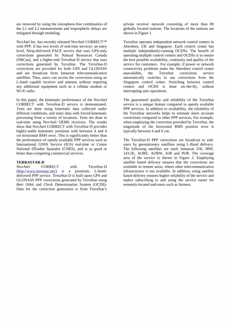
private receiver network consisting of more than 80 globally located stations. The locations of the stations are shown in Figure 1. TerraStar operates independent network control centers in Aberdeen, UK and Singapore. Each control center has multiple independently-running OCDSs. The benefit of operating multiple control centers and OCDSs is to ensure the best possible availability, continuity and quality of the service for customers. For example, if power or network connectivity problems make the Aberdeen control center unavailable, the TerraStar corrections service automatically switches to use corrections from the Singapore control center. Switching between control centers and OCDS is done on–the-fly, without interrupting user operations. The guaranteed quality and reliability of the TerraStar service is a unique feature compared to openly available PPP services. In addition to availability, the reliability of the TerraStar networks helps to estimate more accurate corrections compared to other PPP services. For example, when employing the correction provided by TerraStar, the magnitude of the horizontal RMS position error is typically between 4 and 6 cm. The TerraStar-D PPP corrections are broadcast to end-users by geostationary satellites using L-Band delivery. The following satellites are used: Inmarsat 25E, 98W, 143.5E, AORE, AORW, IOR and POR. The coverage area of the service is shown in Figure 2. Employing satellite based delivery ensures that the corrections are available in remote areas, where other telecommunication infrastructure is not available. In addition, using satellite based delivery ensures higher reliability of the service and makes subscribing to and using the service easier for remotely-located end-users such as farmers.
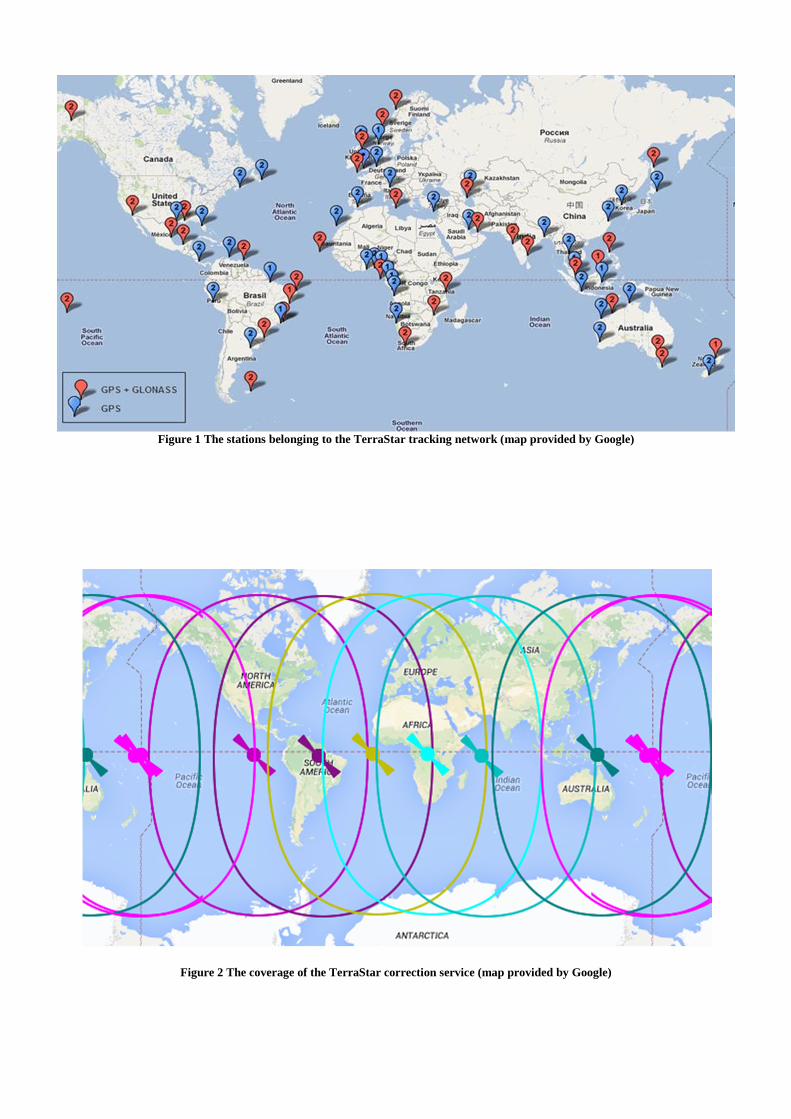
Figure 1 The stations belonging to the TerraStar tracking network (map provided by Google)
Figure 2 The coverage of the TerraStar correction service (map provided by Google)
NOVATEL PACE NovAtel CORRECT™ with PACE is an entry level, Ntrip-delivered service that uses GPS-only corrections generated by Natural Resources Canada (NRCan). The PACE corrections are delivered using Ntrip to selected NovAtel integrators, who then redistribute the corrections to their end-users. There is no guarantee on the quality or availability of service when employing PACE, reflecting its lower cost and intended applications. However, both NovAtel and NRCan have redundant infrastructure that provide higher availability than other publicly available correction products. OTHER CORRECTION SERVICES For comparison purposes, real-time open service PPP corrections from the International GNSS Service (IGS) and the Centre National d'Études Spatiales (CNES) are used (IGS, 2013a; Laurichesse, 2011). Both the IGS (Ntrip mountpoint IGS03) and CNES (mountpoint point CLK9B) feeds provide GPS and GLONASS corrections in the Radio Technical Commission for Maritime Services (RTCM) State Space Representation (SSR) version 3 format (RTCM, 2014). These feeds are designed for research purposes. Thus, unlike TerraStar-D, there is no guarantee on the accuracy and quality of the service. The IGS final post-processed PPP corrections are also used as a performance reference (IGS, 2013b). The scientific community considers the final products to provide the best accuracy, but there is a delay of 12 to 18 days between the collection of data and availability of the products. Thus, the final products are not suitable for any real-time or near real-time applications. As an additional performance reference, the commercial OmniSTAR G2 PPP service (OMNISTAR, 2014) is evaluated. The TerraStar-D, PACE, CNES, IGS real-time, and IGS final corrections are all compared using the same NovAtel CORRECT PPP engine. All OmniSTAR PPP position estimation is done within an OmniSTAR-provided library. PPP ESTIMATION PPP estimation runs on NovAtel OEM6 receivers in real-time. Positions can be estimated at rates up to 20 Hz by employing a novel fast-slow positioning architecture. PPP position estimation is done using an Extended Kalman Filter (EKF) (Larson et al., 1967; Wishner et al., 1969). The NovAtel PPP filter uses state-of-the-art PPP error models. The first-order ionosphere error is completely eliminated by employing the ionosphere-free combination. The combination is calculated using Equation (1) for code-phase measurements and Equation (2) for carrier-phase measurements, where � refers to the GNSS frequency, � refers to code-phase measurements in
meters and � refers carrier-phase measurements in meters. In these equations, indices 1 and 2 refer to the L1 and L2 RF bands, respectively.
�� = 1
�� − �
(��
�� − ��) (1)
�� = 1
�� − �
(��
�� − ��) (2)
The troposphere delay is corrected using the UNB model and mapping function developed by the University of New Brunswick (Collins et al., 1996). The residual, time-varying error remaining after modeling is handled by estimating residual zenith troposphere wet delay as an EKF state. This residual error is mapped into the slant receiver-to-satellite range level using the UNB mapping function. Satellite orbit errors, clock errors, and differential code biases are corrected by the products provided by the correction providers. In the real-time services, it is not necessary to correct for satellite phase center errors as the corrections refer to the satellite phase center. The receiver antenna is also not corrected for, and so the output positions refer to the receiver antenna phase center. Satellite antenna phase wind-up is corrected using the model developed in Wu et al. (1992) and solid earth tides are corrected using the model in Kouba (2009). The following states are estimated within the EKF:
• Position • Residual zenith wet troposphere delay • GPS and GLONASS system biases • Ionosphere-free carrier-phase signal biases
The NovAtel CORRECT with TerraStar-D service employs the fast re-covergence feature, which is based on modelling ionosphere behaviour locally at the receiver and then using the ionosphere estimates to constrain the solution when loss of tracking occurs. The PPP filter dynamics mode can be configured by a user. The available modes are: auto, dynamic and static. In the static mode, it is assumed that the receiver is static and position has zero process noise. In the dynamic mode, it is assumed that the receiver is dynamic and position has large process noise. The auto mode is a novel feature, which detects the filter motion state automatically based on the high rate position solution. If the between-epoch change in the high rate position solution is larger than the tolerance, it is assumed that the receiver is dynamic. Otherwise, it is assumed that the receiver is static. The benefit of the auto mode is to provide faster convergence and more stable solutions when the receiver is only moving part of the time.
STATIC TESTS Static PPP performance is analyzed using data collected from four NovAtel monitoring stations:
1. Calgary, Canada 2. Hyderabad , India 3. Witney, United Kingdom 4. Taichung , Taiwan
Approximately one week of data is used from each location. Multiple locations are chosen to show the performance in different kinds of atmospheric and multipath environments. The stations in India and Taiwan, for instance, are particularly vulnerable to ionosphere scintillation because they are located at low latitudes, within the northern scintillation band. Although the stations are static, the data is processed in the dynamic filter mode, where high position process noise is assumed. At all locations, performance with the TerraStar-D correction feed is compared against performance with the NovAtel PACE feed, the IGS real-time feed, and IGS final orbits and clocks. All solutions are produced using NovAtel’s PPP filter, running in real-time on the receiver
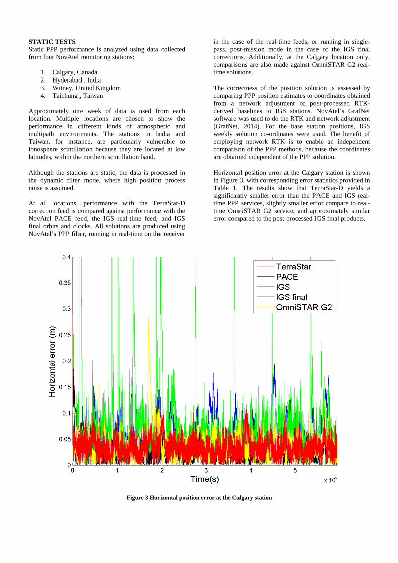
in the case of the real-time feeds, or running in single-pass, post-mission mode in the case of the IGS final corrections. Additionally, at the Calgary location only, comparisons are also made against OmniSTAR G2 real-time solutions. The correctness of the position solution is assessed by comparing PPP position estimates to coordinates obtained from a network adjustment of post-processed RTK-derived baselines to IGS stations. NovAtel’s GrafNet software was used to do the RTK and network adjustment (GrafNet, 2014). For the base station positions, IGS weekly solution co-ordinates were used. The benefit of employing network RTK is to enable an independent comparison of the PPP methods, because the coordinates are obtained independent of the PPP solution. Horizontal position error at the Calgary station is shown in Figure 3, with corresponding error statistics provided in Table 1. The results show that TerraStar-D yields a significantly smaller error than the PACE and IGS real-time PPP services, slightly smaller error compare to real-time OmniSTAR G2 service, and approximately similar error compared to the post-processed IGS final products.
Figure 3 Horizontal position error at the Calgary station
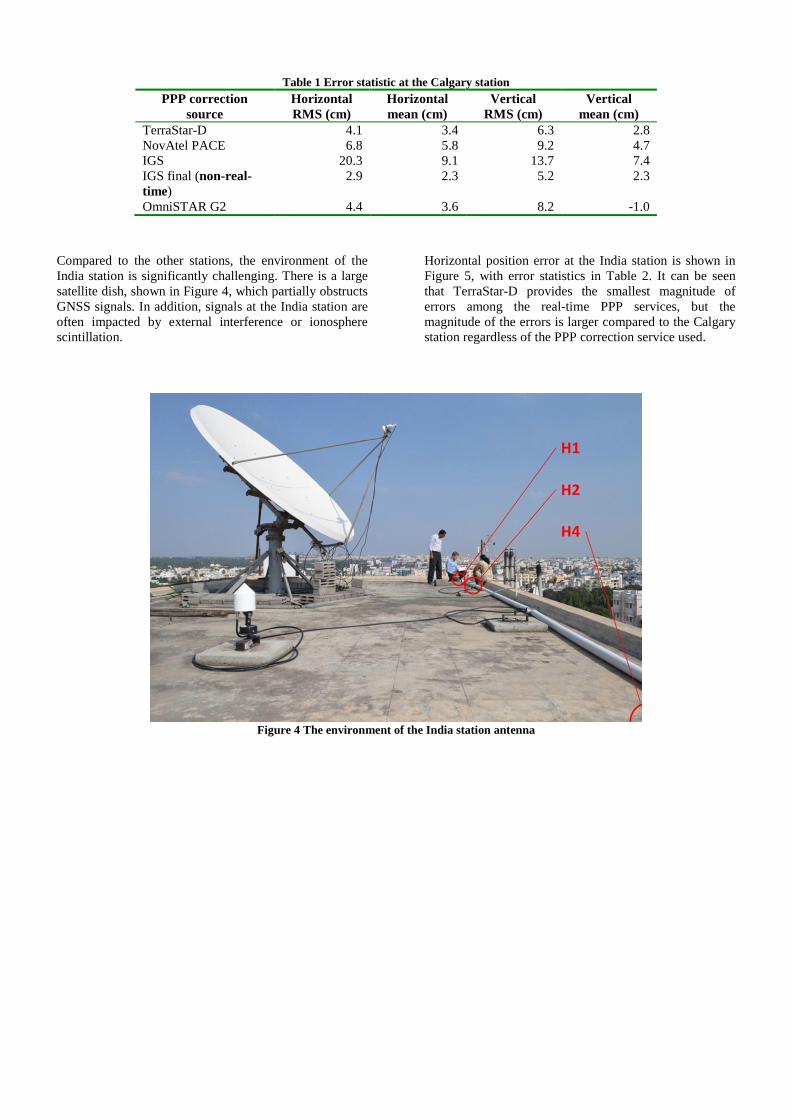
Table 1 Error statistic at the Calgary station PPP correction
source Horizontal RMS (cm)
Horizontal mean (cm)
Vertical RMS (cm)
Vertical mean (cm)
TerraStar-D 4.1 3.4 6.3 2.8 NovAtel PACE 6.8 5.8 9.2 4.7 IGS 20.3 9.1 13.7 7.4 IGS final (non-real-time)
2.9 2.3 5.2 2.3
OmniSTAR G2 4.4 3.6 8.2 -1.0
Compared to the other stations, the environment of the India station is significantly challenging. There is a large satellite dish, shown in Figure 4, which partially obstructs GNSS signals. In addition, signals at the India station are often impacted by external interference or ionosphere scintillation.
Horizontal position error at the India station is shown in Figure 5, with error statistics in Table 2. It can be seen that TerraStar-D provides the smallest magnitude of errors among the real-time PPP services, but the magnitude of the errors is larger compared to the Calgary station regardless of the PPP correction service used.
Figure 4 The environment of the India station antenna

Figure 5 Horizontal position error at the India station
Table 2 Error statistic at the India station PPP correction
source Horizontal RMS (cm)
Horizontal mean (cm)
Vertical RMS (cm)
Vertical mean (cm)
TerraStar-D 5.9 4.8 8.9 1.7 NovAtel PACE 8.2 6.6 12.2 5.7 IGS 13.4 7.9 17.9 4.9 IGS final (non-real-time)
5.6 4.4 9.8 4.1
Horizontal position error at the Taiwan station is shown in Figure 6 and error statistics in Table 3. The results again
show that TerraStar-D provides the smallest error compared to the other real-time PPP services.

Figure 6 Horizontal position error at the Taiwan station
Table 3 Error statistic at the Taiwan station PPP correction
source Horizontal RMS (cm)
Horizontal mean (cm)
Vertical RMS (cm)
Vertical mean (cm)
TerraStar-D 5.7 5.1 7.7 -4.3 NovAtel PACE 6.6 5.7 8.3 0.0 IGS 11.5 6.5 10.9 0.0 IGS final (non-real-time)
4.2 3.6 7.0 0.0
Horizontal position error at the UK station is shown in Figure 7 and error statistics in Table 4. The results at this station are similar to the results obtained using data from
the Calgary stations: TerraStar-D provides significantly smaller error magnitude compared to other PPP services.
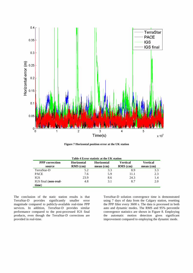
Figure 7 Horizontal position error at the UK station
Table 4 Error statistic at the UK station PPP correction
source Horizontal RMS (cm)
Horizontal mean (cm)
Vertical RMS (cm)
Vertical mean (cm)
TerraStar-D 5.2 3.3 8.9 3.3 PACE 7.6 5.9 11.1 2.3 IGS 23.9 8.6 24.3 1.4 IGS final (non-real-time)
4.8 3.1 8.7 2.0
The conclusion of the static station results is that TerraStar-D provides significantly smaller error magnitude compared to publicly-available real-time PPP services. In addition, TerraStar-D provides similar performance compared to the post-processed IGS final products, even though the TerraStar-D corrections are provided in real-time.
TerraStar-D solution convergence time is demonstrated using 7 days of data from the Calgary station, resetting the PPP filter every 3600 s. The data is processed in both auto and dynamic modes. The RMS and 95% percentile convergence statistics are shown in Figure 8. Employing the automatic motion detection gives significant improvement compared to employing the dynamic mode.

Figure 8 TerraStar-D convergence at the Calgary station
The re-convergence performance of TerraStar-D is demonstrated using approximately one week of data recorded at the Calgary station and simulating 10, 30, 150 and 300 second long complete signal break periods every 3600 s. The re-convergence results are shown in Figure 9. The results show that the TerraStar-D solution recovers quickly after solution outages. NovAtel CORRECT has a fast re-convergence feature which is based on estimating ionospheric delay during the normal operation and using the estimates in the case of signal outages when there is an insufficient number of satellites available to the calculate the solution. This
feature enables typically fast re-convergence in the cases of signal outages shorter than 300 s. However, the re-convergence performance is dependent on the length of signal outage and activity of ionosphere. The fast re-convergence feature is available to all NovAtel CORRECT users. The benefit of employing the TerraStar-D fast-reconvergence feature compared to regular convegence is shown in Figure 10. The results show that the fast re-convergence feature improves performance significantly.

Figure 9 TerraStar-D re-convergence at the Calgary station
Figure 10 The benefit of employing the TerraStar-D fast re-convergence feature (Calgary station)

KINEMATIC TESTS Kinematic performance is first tested using data recorded at a farm, located in Indiana. The performance of TerraStar-D is compared to the PACE, IGS and CNES real-time PPP correction services and IGS final post-processed correction products. The ground-track of the device is shown in Figure 11. The reference track of the test is obtained using RTK. The IGS08 coordinates of the local reference station is obtained using a network RTK solution, where station coordinates are fixed to the values given by the IGS weekly solution. Thereafter, the reference track of the rover is estimated by calculating an RTK solution between the rover and local reference station.
The horizontal position error obtained using different PPP correction services is shown in Figure 12. The results show that TerraStar-D provides the smallest error magnitude even when compared to the IGS final corrections.
Figure 11 Ground track of the Indiana field-test (Map provided by Google)

Figure 12 Horizontal position error (m) at the Indiana field-test
The second kinematic test is done in Brazil and the ground-track of the device is shown in Figure 13. The test route is a typical example of a farming environment in Brazil. Compared to places such as Calgary, using PPP in Brazil is more challenging, as regular ionospheric scintillation causes receivers to often lose lock, particularly to the GPS P2 signal. In addition, L-Band based PPP correction delivery such as TerraStar-D is often the only suitable way to provide corrections,
because of the lack of cellular coverage and reliability of cellular connections in many areas in Brazil. A comparison between TerraStar-D and OmniSTAR G2 PPP services is shown in Figure 14. The results show that both correction services can provide similar performance.

Figure 13 Ground track of the Brazil field-test (Map provided by Google, image by DigitalGlobe)
Figure 14 Horizontal position error (m) at the Brazil field-test
CONCLUSIONS The performance of TerraStar-D was demonstrated using both static and kinematic data. This performance was compared to the IGS, CNES and NRCAN (PACE) real-time PPP services, IGS post-processed final correction products and OmniSTAR G2 commercial PPP service. The results show that TerraStar-D provides better performance than the IGS, CNES or NRCAN real-time PPP services and similar performance compared to OmniSTAR G2 and post-processed IGS final corrections. The horizontal RMS error of the converged solution is typically between 4 and 6 cm when employing TerraStar-D. That is suitable for many high accuracy applications. The reliability and availability of the positioning solution is important for commercial applications. When employing TerraStar-D, there is a guarantee on the reliability and continuity of the positioning service. TerraStar is continuously monitoring their corrections at the OCDS and there are two parallel solutions running at each TerraStar network control center in Aberdeen, UK and Singapore. If issues occur, TerraStar will switch between the sources with no interruption in service to the user. The reliability of TerraStar-D is a significant benefit compared to open PPP services such as IGS and CNES. Employing TerraStar-D is easy for the end-user, because only a TerraStar-D enabled and subscribed GNSS receiver and L-Band supporting antenna is needed. The NovAtel CORRECT with TerraStar-D solution provides cost savings for the user because no additional equipment is required. Delivery of corrections over L-band also simplifies logistics and lowers costs for the user since network connectivity may be unreliable or expensive in remote areas. FUTURE WORK In the short term, NovAtel and TerraStar are working to improve TerraStar initial convergence and re-convergence performance on the OEM6 receivers through carrier-phase ambiguity resolution. It is expected that future implementation of carrier-phase ambiguity resolution will enable instant solution re-convergence for NovAtel and TerraStar customers. The longer term plan is to support new constellations such as BeiDou and Galileo and new signals such as GPS L5. REFERENCES COLLINS, P., LANGLEY, R. B & LAMANCE, J. 1996.
Limiting Factors in Tropospheric Propagation Delay Error Modelling for GPS Airborne Navigation. The Institute of Navigation 52nd Annual meeting, Massachusetts, USA
COUNSELMAN, C. C. & GOUREVITCH, S. A. 1981. Miniature Interferometer Terminals for Earth. Surveying: Ambiguity and Multipath with.
Global Positioning System. IEEE Transactions on Geoscience and Remote Sensing, GE-19.
GRAFNET. 2014. NovAtel GrafNet [Online]. Available: http://www.novatel.com/products/software/grafnav-static-and-grafnet/#overview [Accessed 2 July 2014].
IGS. 2013a. IGS real-time service [Online]. Available: http://rts.igs.org/products/ [Accessed 28 May 2014].
IGS. 2013b. IGS products [Online]. Available: http://igscb.jpl.nasa.gov/components/prods.html [Accessed 2 July 2014].
OMNISTAR. 2014. OmniSTAR G2 [Online]. Available: http://www.omnistar.com/ [Accessed 28 May 2014].
KOUBA, J. 2009. Guide to using International GNSS service (IGS) products.
LAURICHESSE, D. 2011. The CNES Real-time PPP with undifferenced integer ambiguity resolution demonstrator. Proceedings of the 24th International Technical Meeting of The Satellite Division of the Institute of Navigation (ION GNSS 2011). Portland, Oregon.
LARSON, R. E., DRESSLER, R. M. & RATNER, R. S. 1967. Application of the Extended Kalman filter to ballistic trajectory estimation. Menlo Park, CA: Stanford Res. Inst.
REMONDI, B. W. 1984. Using the global positioning system (GPS) phase observable for relative geodesy: Modeling, processing, and results PhD thesis University of Texas.
RTCM. 2014. The Radio Technical Commission for Maritime Services [Online]. Available: http://www.rtcm.org/ [Accessed 28 May 2014].
WISHNER, R. P., TABACZYNSKI, J. A. & ATHANS, M. 1969. A comparison of three non-linear filters. Automatica, 5, 487–496.
WU, J. T., WU, S. C., HAJJ, G. A., BERTIGER, W. I. & LICHTEN, S. M. 1992. Effects of antenna orientation on GPS carrier phase. Astrodynamics, 18, 91-98.
ZUMBERGE, J. F., HEFTIN, M. B., JEFFERSON, D. C., WATKINS, M. M. & WEBB, F. H. 1997. Precise point positioning for the efficient and robust analysis of GPS data from large networks. Journal of Geophysical Research, 102, 5005-5017.