key - cotswold district council elections · reproduced by permission of ordnance survey on behalf...
TRANSCRIPT
Cirencester ParkConservation Area
Cirencester SouthConservation Area
CirencesterTown Centre
Conservation Area
1155
Hall
PH
PH
PH
PH
PH
PHPH
PH
PH
PC
PC
PO
PO
The
Hall
Corn
Hall
Hall
Court
New
Centre
PCsWAY
WAY
WAY
Club
Bldgs
Tallet
Walk
Court
Jobbins
Black
Court
Bank
BankBank Bank
Mill Cott
Cottage
Hotel
Hotel
Mews
A 419
Court
Court
Office
Picton
Castle
GDNS
Memorial
Lodge
Lodge
House
House
House
House
WEST
King's
Offic
e
Niccol
Akeman
Barnes
Church
Manse
Mill House
Librar
y
Centre
Court
Court
Court
Court
Block A
Bakery
School
Church
Churc
h
Presby
Church
BldgsCottage
NORTH
Clinton Ho
Grove
Akeman
Garage
Garage
Hanover Ct
Pavilion
Nursery
Register
Museum
Place
Coxwell
Surgery
Surgery
Abbey
Hoopers
House
St Blaize
Queen Anne
Northway
STRE
ET
Regis
try
Birchfield
Museum
Old Court
St Peter's
Church
Templar Mews
Minerva
Exchange
Jack Mews
The Garden Ho
Baptist's
HAMMOND
El Sub Sta
Telephone
GOSDITCH
ASHCROFT
Magistrates
PARK LANE
Corn Hall
Farrell CloseSt Peter's
Cotswold Mill
Leaholme
SOUTH WAY
CECILY HILL
Forum House
LEWIS LANEOakley House
Bishop's Walk
Colvi
lle Ho
use
The Old Post Office
DYER STREET
Police Station
Woolrich House
St John the
PARK STREET
CRIPPS ROAD
Homeberry Ho
QUERNS LANE
St James's
Almshouses
Cirencester Park
The Old School
SHEEP STREET
Wellington House
SILVER STREET
THE WATERLOO
TOWER STREET
CASTLE STREET
Bowly's Pump
ASHCROFT ROAD
ST PETERS ROAD
Palestra Lodge
WEST MARKET PL
BREWERY COURT
COXWELL STREET
MARKET PLACE
CRICKLADE STREET
BLACK JACK STREET
ASHCROFT GARDENS
Grismond's Tower
402000
402000
2020
00
2020
00
Project
Drawing Number
Drawn
Title
Checked ApprovedSLJS SL 09/05/20161:2,400 @ A3
Genesis Centre, Birchwood Science Park, Warrington WA3 7BHTel 01925 844004 e-mail [email protected] www.tep.uk.com
Scale Date
Rev Description Drawn Approved Date
Site Map
1:20,000
0 50 10025Metres
Reproduced by permission of Ordnance Survey on behalf of Her Majesty's Stationery Office.© Crown Copyright and database right 2016. All rights reserved.© Crown copyright and database rights 2016 Ordnance Survey 100018800
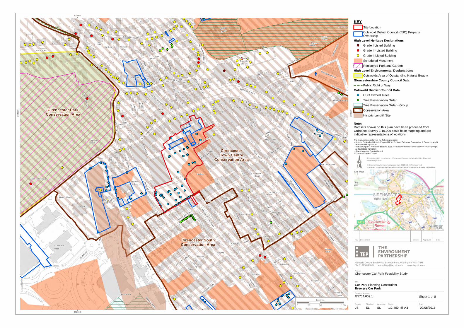
KEYSite LocationCotswold District Council (CDC) PropertyOwnership
High Level Heritage DesignationsGrade I Listed BuildingGrade II* Listed BuildingGrade II Listed BuildingScheduled MonumentRegistered Park and Garden
High Level Environmental DesignationsCotswolds Area of Outstanding Natural Beauty
Gloucestershire County Council DataPublic Right of Way
Cotswold District Council DataCDC Owned TreesTree Preservation OrderTree Preservation Order - GroupConservation AreaHistoric Landfill Site
Sheet 1 of 8
Car Park Planning ConstraintsBrewery Car Park
Cirencester Car Park Feasibility Study
G5704.002.1
This map contains data from the following sources: - Historic England - © Historic England 2016. Contains Ordnance Survey data © Crown copyright and database right 2016 - Natural England - © Natural England 2016. Contains Ordnance Survey data © Crown copyright and database right 2016 - Gloucestershire County Council - Cotswold District Council
Note:Datasets shown on this plan have been produced from Ordnance Survey 1:10,000 scale base mapping and are indicative representations of locations
Cirencester ParkConservation Area
Cirencester SouthConservation Area
CirencesterTown Centre
Conservation Area
PH
PH
PH
PC
PO
PO
Surgery
Hall
Centre
WAY
Club
Bank
Bank
Mews
A 419
A 419
Office
Castle
Memorial
Lodge
Offic
e
Niccol
Church
Manse
Centre
Court
School
Surgery
Church
Presby
Garage
Garage
Pavilion
Nursery
Museum
Place
Register
Regis
try
St Peter's
Leisure
The Garden Ho
HAMMOND
El Sub Sta
Cotswold
PARK LANE
Farrell CloseSt Peter's
Oakley House
Sports Centre
Bishop's Walk
The Old Post Office
CRIPPS ROAD
QUERNS LANE
St James's
Cirencester Park
TETBURY ROAD
SILVER STREET
CASTLE STREET
ASHCROFT ROAD
ST PETERS ROAD
BREWERY COURT
Cirencester
ASHCROFT GARDENS
Grismond's Tower
402000
402000
2020
00
2020
00
Project
Drawing Number
Drawn
Title
Checked ApprovedSLJS SL 09/05/20161:1,800 @ A3
Genesis Centre, Birchwood Science Park, Warrington WA3 7BHTel 01925 844004 e-mail [email protected] www.tep.uk.com
Scale Date
Rev Description Drawn Approved Date
Site Map
1:20,000
0 40 8020Metres
Reproduced by permission of Ordnance Survey on behalf of Her Majesty's Stationery Office.© Crown Copyright and database right 2016. All rights reserved.© Crown copyright and database rights 2016 Ordnance Survey 100018800
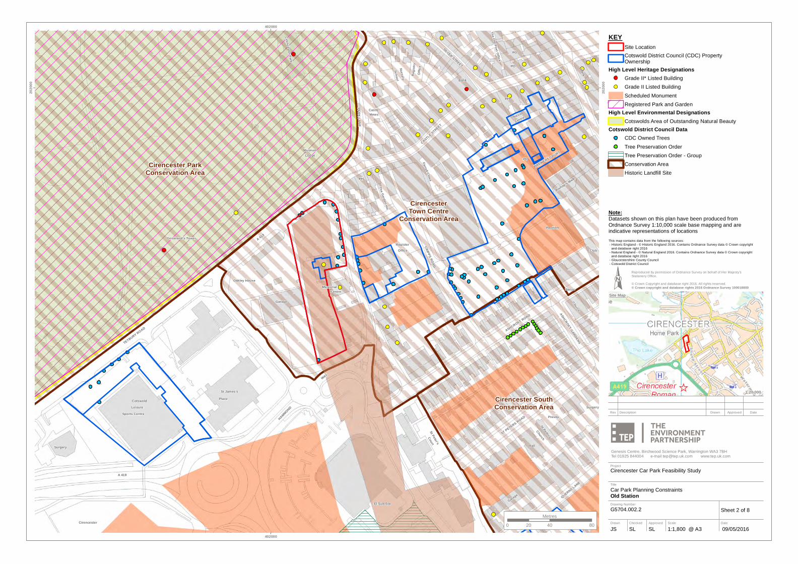
KEYSite LocationCotswold District Council (CDC) PropertyOwnership
High Level Heritage DesignationsGrade II* Listed BuildingGrade II Listed BuildingScheduled MonumentRegistered Park and Garden
High Level Environmental DesignationsCotswolds Area of Outstanding Natural Beauty
Cotswold District Council DataCDC Owned TreesTree Preservation OrderTree Preservation Order - GroupConservation AreaHistoric Landfill Site
Sheet 2 of 8
Car Park Planning ConstraintsOld Station
Cirencester Car Park Feasibility Study
G5704.002.2
This map contains data from the following sources: - Historic England - © Historic England 2016. Contains Ordnance Survey data © Crown copyright and database right 2016 - Natural England - © Natural England 2016. Contains Ordnance Survey data © Crown copyright and database right 2016 - Gloucestershire County Council - Cotswold District Council
Note:Datasets shown on this plan have been produced from Ordnance Survey 1:10,000 scale base mapping and are indicative representations of locations
Cirencester ParkConservation Area
Cirencester SouthConservation Area
CirencesterTown Centre
Conservation Area
Oakley House
PH
PH
PC
WAY
Centre
A 419
Office
Lodge
Memorial
Garage
Register
Museum
The Garden Ho
Farrell Close
CASTLE STREET
CRIPPS ROAD
ASHCROFT ROAD
402000
402000
Project
Drawing Number
Drawn
Title
Checked ApprovedSLJS SL 09/05/20161:900 @ A3
Genesis Centre, Birchwood Science Park, Warrington WA3 7BHTel 01925 844004 e-mail [email protected] www.tep.uk.com
Scale Date
Rev Description Drawn Approved Date
Site Map
1:9,000
0 20 4010Metres
Reproduced by permission of Ordnance Survey on behalf of Her Majesty's Stationery Office.© Crown Copyright and database right 2016. All rights reserved.© Crown copyright and database rights 2016 Ordnance Survey 100018800
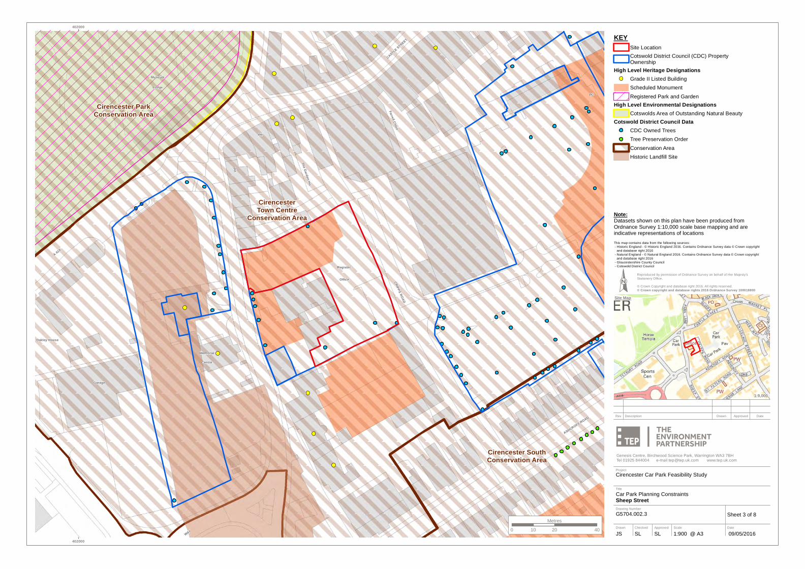
KEYSite LocationCotswold District Council (CDC) PropertyOwnership
High Level Heritage DesignationsGrade II Listed BuildingScheduled MonumentRegistered Park and Garden
High Level Environmental DesignationsCotswolds Area of Outstanding Natural Beauty
Cotswold District Council DataCDC Owned TreesTree Preservation OrderConservation AreaHistoric Landfill Site
Sheet 3 of 8
Car Park Planning ConstraintsSheep Street
Cirencester Car Park Feasibility Study
G5704.002.3
This map contains data from the following sources: - Historic England - © Historic England 2016. Contains Ordnance Survey data © Crown copyright and database right 2016 - Natural England - © Natural England 2016. Contains Ordnance Survey data © Crown copyright and database right 2016 - Gloucestershire County Council - Cotswold District Council
Note:Datasets shown on this plan have been produced from Ordnance Survey 1:10,000 scale base mapping and are indicative representations of locations

Cirencester ParkConservation Area
CirencesterTown Centre
Conservation Area
Gloucester Streetand River Walk
Conservation Area
Gloucester Streetand River Walk
Conservation Area
1155
Hall
Hall
Hill
PH
PH
PH
PH
PC
PO
PO
The
TheThe
The
Corn
Hall
Hall
PW
PW
Little
Bldgs
Tallet
Black
Court
Bank BankBank
Mead
Hotel
Hotel
Hotel
Court
Picton
Hous
e
St John's
House
House
Lodge
House
Walk
Depot
Offic
e
Barnes
House
Librar
y
Ashley
Court
Court
Court
Stables
Bakery
School
Close
CLOSE
Church
Mullings
Grove
Nursery
Coxwell
AbbeyHouse
PRIORYBarton
STRE
ET
Regis
try
Museum
Old Court
Church
Alexander
Templar Mews
Clinton Ho
Chantry
Jack Mews
Gatehouse
Baptist's
of England
GOSDITCH
Mead House
Paget House
The Vineyard
Smyth
Hous
e
Admira
lty Row
Colvi
lle Ho
use
The Old Post Office
Goos
eacre
BLAKE ROAD
St John the
PARK STREET
Woolrich House
Primary School
Cirencester Park
St Clement's
Powell's Church
GOOS
EACR
E LAN
E
Wellington House
SILVER STREET
ESTCOTE ROAD
THE WATERLOO
DUGDALE ROAD
DOLLAR STREET
THOMAS STREET
HAKEBURN ROAD
Palestra Lodge
WEST MARKET PL
HEREWARD ROAD
SPITA
LGAT
E LAN
E
TRAFALGAR ROAD
COXWELL STREET
TRAFALGAR ROAD
MARKET PLACE
BLACK JACK STREET
GLOUCESTER STREET
402000
402000
Project
Drawing Number
Drawn
Title
Checked ApprovedSLJS SL 09/05/20161:2,200 @ A3
Genesis Centre, Birchwood Science Park, Warrington WA3 7BHTel 01925 844004 e-mail [email protected] www.tep.uk.com
Scale Date
Rev Description Drawn Approved Date
Site Map
1:20,000
0 50 10025Metres
Reproduced by permission of Ordnance Survey on behalf of Her Majesty's Stationery Office.© Crown Copyright and database right 2016. All rights reserved.© Crown copyright and database rights 2016 Ordnance Survey 100018800
KEYSite LocationCotswold District Council (CDC) PropertyOwnership
High Level Heritage DesignationsGrade I Listed BuildingGrade II* Listed BuildingGrade II Listed BuildingScheduled MonumentRegistered Park and Garden
High Level Environmental DesignationsCotswolds Area of Outstanding Natural Beauty
Gloucestershire County Council DataPublic Right of Way
Cotswold District Council DataCDC Owned TreesTree Preservation OrderTree Preservation Order - GroupConservation Area
Sheet 4 of 8
Car Park Planning ConstraintsAbbey Grounds
Cirencester Car Park Feasibility Study
G5704.002.4
This map contains data from the following sources: - Historic England - © Historic England 2016. Contains Ordnance Survey data © Crown copyright and database right 2016 - Natural England - © Natural England 2016. Contains Ordnance Survey data © Crown copyright and database right 2016 - Gloucestershire County Council - Cotswold District Council
Note:Datasets shown on this plan have been produced from Ordnance Survey 1:10,000 scale base mapping and are indicative representations of locations
Cirencester ParkConservation Area
CirencesterTown Centre
Conservation Area
PH
Centre
WAY
A 419
A 419
Memorial
Lodge
Phoenix House
Querns
A 419
Surgery
Garage
Place
Leisure
HAMMOND
Cotswold
Oakley House
Sports Centre
Keepers Gate
Hospital
St James's
TETBURY ROAD
Cirencester
Grismond's Tower
402000
402000
Project
Drawing Number
Drawn
Title
Checked ApprovedSLJS SL 09/05/20161:1,400 @ A3
Genesis Centre, Birchwood Science Park, Warrington WA3 7BHTel 01925 844004 e-mail [email protected] www.tep.uk.com
Scale Date
Rev Description Drawn Approved Date
Site Map
1:10,000
0 30 6015Metres
Reproduced by permission of Ordnance Survey on behalf of Her Majesty's Stationery Office.© Crown Copyright and database right 2016. All rights reserved.© Crown copyright and database rights 2016 Ordnance Survey 100018800
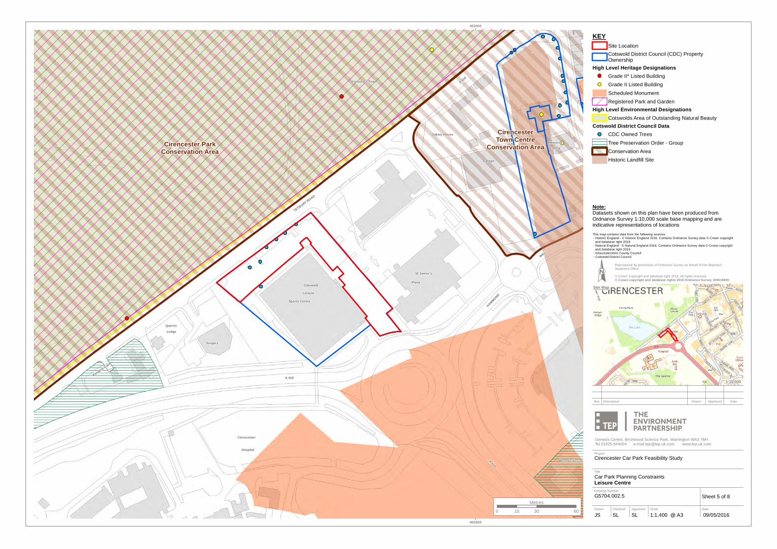
KEYSite LocationCotswold District Council (CDC) PropertyOwnership
High Level Heritage DesignationsGrade II* Listed BuildingGrade II Listed BuildingScheduled MonumentRegistered Park and Garden
High Level Environmental DesignationsCotswolds Area of Outstanding Natural Beauty
Cotswold District Council DataCDC Owned TreesTree Preservation Order - GroupConservation AreaHistoric Landfill Site
Sheet 5 of 8
Car Park Planning ConstraintsLeisure Centre
Cirencester Car Park Feasibility Study
G5704.002.5
This map contains data from the following sources: - Historic England - © Historic England 2016. Contains Ordnance Survey data © Crown copyright and database right 2016 - Natural England - © Natural England 2016. Contains Ordnance Survey data © Crown copyright and database right 2016 - Gloucestershire County Council - Cotswold District Council
Note:Datasets shown on this plan have been produced from Ordnance Survey 1:10,000 scale base mapping and are indicative representations of locations
Cirencester SouthConservation Area
CirencesterTown Centre
Conservation Area
Librar
y
Hall
PH
PH
PH
PH
Court
The
Corn
Hall
Court
New
House
PCs
WAY
WAY
CroftClub
Bldgs
Walk
Court
Court
Jobbins
Court
Bank
Bank Bank
Mill Cott
Hotel
Hotel
Mews
Court
GDNS
House
WEST
King's
Akeman
Manse
Mill House
Court
Church
Churc
h
Bldgs
NORTH
Akeman
Surgery
Hoopers
St Blaize
Queen Anne
Northway
Arkenside
Minerva
ExchangeTelephone
ASHCROFT
Magistrates
Corn Hall
Bishop's Walk
Cotswold MillSOUTH WAY
Forum House
LEWIS LANE
THE AVENUE
Police Station
Carpenters Buildings
DYER STREET
Woolrich House
Homeberry Ho
THE WATERLOO
The Old School
TOWER STREET
Coach House Mews
Cambray Court
CARPENTERS LANE
MARKET PLACE
CRICKLADE STREET
ASHCROFT GARDENS
2020
00
2020
00
Project
Drawing Number
Drawn
Title
Checked ApprovedSLJS SL 09/05/20161:1,500 @ A3
Genesis Centre, Birchwood Science Park, Warrington WA3 7BHTel 01925 844004 e-mail [email protected] www.tep.uk.com
Scale Date
Rev Description Drawn Approved Date
Site Map
1:10,000
0 30 6015Metres
Reproduced by permission of Ordnance Survey on behalf of Her Majesty's Stationery Office.© Crown Copyright and database right 2016. All rights reserved.© Crown copyright and database rights 2016 Ordnance Survey 100018800
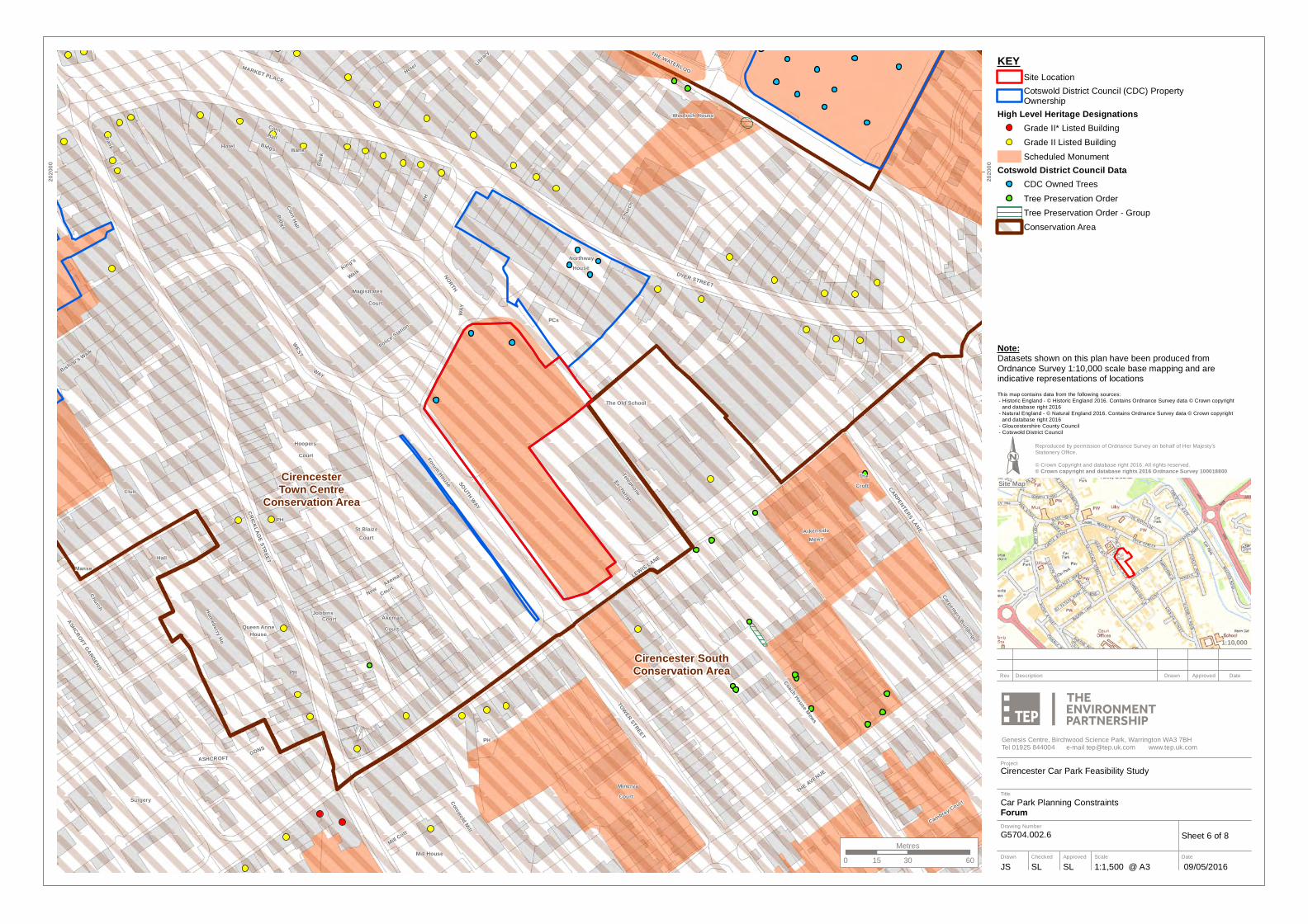
KEYSite LocationCotswold District Council (CDC) PropertyOwnership
High Level Heritage DesignationsGrade II* Listed BuildingGrade II Listed BuildingScheduled Monument
Cotswold District Council DataCDC Owned TreesTree Preservation OrderTree Preservation Order - GroupConservation Area
Sheet 6 of 8
Car Park Planning ConstraintsForum
Cirencester Car Park Feasibility Study
G5704.002.6
This map contains data from the following sources: - Historic England - © Historic England 2016. Contains Ordnance Survey data © Crown copyright and database right 2016 - Natural England - © Natural England 2016. Contains Ordnance Survey data © Crown copyright and database right 2016 - Gloucestershire County Council - Cotswold District Council
Note:Datasets shown on this plan have been produced from Ordnance Survey 1:10,000 scale base mapping and are indicative representations of locations

Cirencester SouthConservation Area
CirencesterTown Centre
Conservation Area
Hall
Hill
PH
PH
PH
PC
PC
The
Corn
PCsWAY
WAY
Croft
Bldgs
Walk
Court
Court
BankBank
Hotel
Hotel
Mews
Court
Picton
House
Hous
e
House
House
House
WEST
King's
Oxford
Barnes
House
Librar
y
Court
Court
Bakery
A 429
Shelter
Churc
h
Bldgs
NORTH
Grove
Theatre
Hoopers
St Blaize
Northway
Church
Arkenside
London Place
Clinton Ho
GROVE LANE
LONDON ROAD
Exchange
Bravender
Baptist's
Telephone
Magistrates
Corn Hall
Paget HouseSm
yth Ho
use
SOUTH WAY
Forum House
Colvi
lle Ho
use
The Apple Loft
Newcombe
Police Station
St John the
DYER STREET
Woolrich House
PURLEY ROAD
LONDON ROAD
The Old School
CRICKLADE STREET
Wellington House
Ingleside House
CORINIUM GATE
BEECHES ROAD
THE WATERLOO
Palestra Lodge
Orchard House
CARPENTERS LANE
MARKET PLACE
2020
00
2020
00
Project
Drawing Number
Drawn
Title
Checked ApprovedSLJS SL 09/05/20161:2,100 @ A3
Genesis Centre, Birchwood Science Park, Warrington WA3 7BHTel 01925 844004 e-mail [email protected] www.tep.uk.com
Scale Date
Rev Description Drawn Approved Date
Site Map
1:20,000
0 40 8020Metres
Reproduced by permission of Ordnance Survey on behalf of Her Majesty's Stationery Office.© Crown Copyright and database right 2016. All rights reserved.© Crown copyright and database rights 2016 Ordnance Survey 100018800
KEYSite LocationCotswold District Council (CDC) PropertyOwnership
High Level Heritage DesignationsGrade II* Listed BuildingGrade II Listed BuildingScheduled Monument
Cotswold District Council DataCDC Owned TreesTree Preservation OrderTree Preservation Order - GroupConservation Area
Sheet 7 of 8
Car Park Planning ConstraintsThe Waterloo
Cirencester Car Park Feasibility Study
G5704.002.7
This map contains data from the following sources: - Historic England - © Historic England 2016. Contains Ordnance Survey data © Crown copyright and database right 2016 - Natural England - © Natural England 2016. Contains Ordnance Survey data © Crown copyright and database right 2016 - Gloucestershire County Council - Cotswold District Council
Note:Datasets shown on this plan have been produced from Ordnance Survey 1:10,000 scale base mapping and are indicative representations of locations
Cirencester SouthConservation Area
CirencesterTown Centre
Conservation Area
2767
PH
PH
PC
TheCroft
STARK
Court
A429
Mews
A 417
HouseOxford
House
HERB
ERT
Court
Jeffries
A 429
BEECH
Shelter
Garage
Garage
GROVE
River Court
Theatre
Nursery
Paget House
Arkenside
London Place
Childrens
Rivercourt Cott
Bravender
Park House
THE AVENUE
The Apple Loft
Newcombe
BEECHES ROAD
Carpenters Buildings
Beech Grove Ct
PURLEY ROAD
LONDON ROAD
LONDON ROAD
Ingleside House
BEECHES ROADPURLEY AVENUE
ST MARY'S ROAD
Coach House Mews
Orchard House
UPPE
R CH
URNS
IDE
CARPENTERS LANE
QUEEN ANNE'S ROAD
403000
403000
2020
00
2020
00
Project
Drawing Number
Drawn
Title
Checked ApprovedSLJS SL 09/05/20161:1,800 @ A3
Genesis Centre, Birchwood Science Park, Warrington WA3 7BHTel 01925 844004 e-mail [email protected] www.tep.uk.com
Scale Date
Rev Description Drawn Approved Date
Site Map
1:20,000
0 40 8020Metres
Reproduced by permission of Ordnance Survey on behalf of Her Majesty's Stationery Office.© Crown Copyright and database right 2016. All rights reserved.© Crown copyright and database rights 2016 Ordnance Survey 100018800
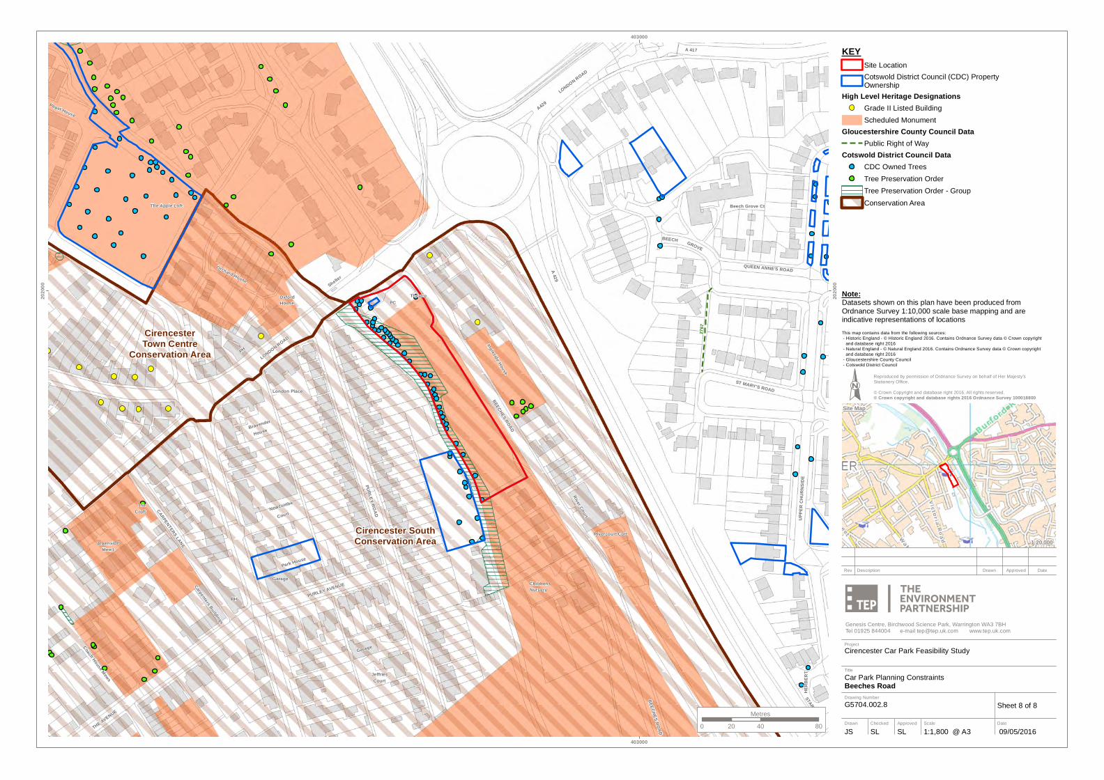
KEYSite LocationCotswold District Council (CDC) PropertyOwnership
High Level Heritage DesignationsGrade II Listed BuildingScheduled Monument
Gloucestershire County Council DataPublic Right of Way
Cotswold District Council DataCDC Owned TreesTree Preservation OrderTree Preservation Order - GroupConservation Area
Sheet 8 of 8
Car Park Planning ConstraintsBeeches Road
Cirencester Car Park Feasibility Study
G5704.002.8
This map contains data from the following sources: - Historic England - © Historic England 2016. Contains Ordnance Survey data © Crown copyright and database right 2016 - Natural England - © Natural England 2016. Contains Ordnance Survey data © Crown copyright and database right 2016 - Gloucestershire County Council - Cotswold District Council
Note:Datasets shown on this plan have been produced from Ordnance Survey 1:10,000 scale base mapping and are indicative representations of locations