kespry part 107 content summary...kespry part 107 content summary -first 2 numbers are the day of...
TRANSCRIPT

Kespry Part 107 Content Summary
Ready for the FAA Part 107 Exam? Here are the key concepts to review just before you take
the test!
1. Regulations Part 107 Applies to:
● Commercial Operations, meaning any time someone is getting paid to fly a UAS, or
making money from the results of a UAS flight.
● All UASs between .55 and 55lbs.
● There are additional limits if the UAS is transporting cargo.
● Many provisions can be waived by applying for a certificate of waiver.
When you fly:
● Sunrise to Sunset – the FAA refers to this as between the beginning of “morning civil
twilight” and the end of “evening civil twilight.”
● Have visibility of at least 3 miles, and don’t fly within 500 feet vertically and 2000 feet
horizontally of a cloud.
Where you fly:
● Never operate anywhere that would interfere with operations of an airport.
● Comply with all TFRs (temporary flight restrictions) and NOTAMs (notices to airmen).
Check NOTAMs by contacting a flight service or using airmap.io.
● Get appropriate air traffic control permission based on airspace before flying.
● Don’t fly over people unless they are involved in the operation or under safe cover.
● You may operate from a moving vehicle in a sparsely populated area.
How you fly:
● Maintain visual line of sight (unaided, so no binoculars). It’s okay to look away
momentarily for safety (for example, to check the status on the iPad) or for operational
necessity (if the drone needs to momentarily fly behind a building).
● Fly no faster than 100 mph.
● Fly no higher than 400 feet AGL (above ground level or within 400 feet of a structure).
● Be aware of other air traffic. Be able to maneuver to avoid a collision. Yield right of
way to other aircraft.
● Don’t operate carelessly or recklessly.
● Don’t operate while impaired by alcohol or other medications.

Kespry Part 107 Content Summary
2. Airspace
Controlled Airspace
● Prior authorization from ATC (Air Traffic Control) is required before operating UAS in
controlled airspace
● Class A = Altitude
○ From 18,000’ MSL to 60,000’ MSL
○ Not relevant to UAS operations
● Class B = Big
○ Surface to 10,000’ MSL around the largest airports in the country
○ Shaped like an upside down wedding cake with several tiers
● Class C = Crowded
○ Surface to 4,000’ above large or crowded airport
○ Shaped like an upside down wedding cake with only 2 tiers
● Class D = Dinky
○ Surface to 2,500’ above a smaller towered airport
● Class E = Elsewhere
○ Anything between the top of airspace and 18,000’
○ Federal airways, some airports are also Class E
Uncontrolled Airspace
● Class G = Go for it!
○ Uncontrolled airspace, do not need prior authorization
○ Imagine painting the surface of the earth - Class G airspace goes from the
surface to either 700’, 1200’, or 14,500’
Special Airspace
● Prohibited Areas: flight is prohibited for security or national welfare, like the White
House or Camp David
● Restricted Areas: unusual operations that are hazardous to aircraft, like artillery fire;
permission is required before entering
● Warning Areas: border areas where U.S. does not have sole jurisdiction, begins 3
nautical miles from the coast
● Military Operations Area (MOA): areas for military training; hours of operation are listed
on the back of the sectional
● Alert Areas: high volume of training or unusual activity, no restrictions but use caution

Kespry Part 107 Content Summary ● Controlled Firing Areas (CFAs): not depicted on charts because there is a lookout that
suspends operations when other aircraft are nearby
● Military Training Route (MTR): special routes for fast, low flight by military aircraft
○ Shown as gray line on sectional chart, either “IR” or “VR” and 3 or 4 numbers
○ 4 numbers means that the entire route is below 1,500’ AGL and could be
hazardous to UAS operations
○ 3 numbers means one segment or more of the route is above 1,500’ AGL
● Temporary Flight Restrictions (TFRs): restrictions on flight in a particular area due to a
special event or circumstance
○ Not indicated on a sectional chart because they can last only a few hours or days
○ Some examples are presidential travel, emergency response or firefighting
operations, and large gatherings of people like sports events
Notices to Airmen (NOTAMs)
● NOTAMs are time-critical aeronautical information not present on a sectional chart.
● NOTAMs can contain airport closures, TFRs, or hazards like parachute jumps or birds.
● NOTAMs can be obtained through the FAA website, a flight weather briefing phone
call, or airmap.io.
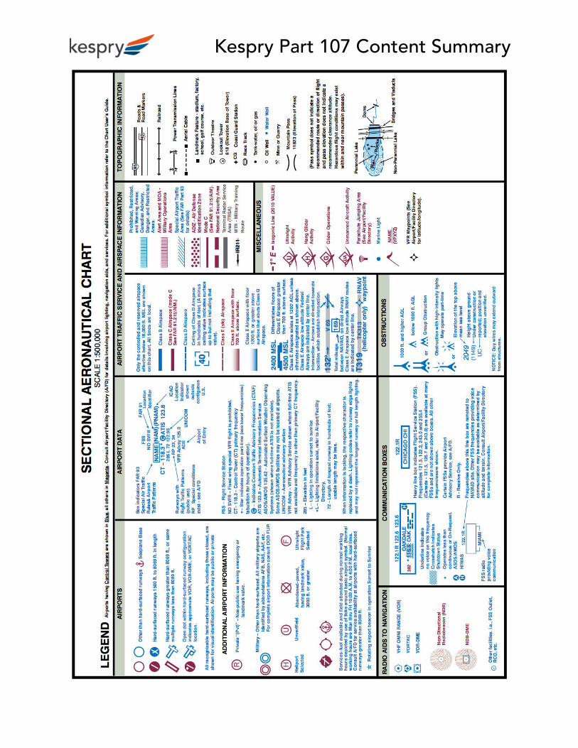
How to Interpret a Sectional Chart
● A sectional chart a regular map with additional detail about airports and obstacles.
● Towns and cities are shown in yellow to suggest what their shape would be at night.
● Some key concepts:
○ Airport information will contain the name, radio frequencies, elevation, lights,
airspace ceilings, and floors.
○ Black lines of latitude and longitude are labeled near where they intersect.
○ A magenta flag icon denotes a visual waypoint for navigation - there will be
more airplanes near these areas.
○ Military training routes are gray lines, with a name like IR-1234 or VR-123; if
there are 4 numbers the entire route is below 1,500’ AGL
● Interactive: On the sectional chart on the next page, can you find:
● Gustine Airport?
● The class airspace around Oakdale airport?
● A military training route?
● An obstacle taller than 1400ft MSL?
● You’ll most likely have access to a legend like the one on the page after during the test
– no need to memorize these!

Kespry Part 107 Content Summary
Kespry Part 107 Content Summary

Kespry Part 107 Content Summary 3. Weather Atmospheric Pressure and Stability
● Summary:
○ Stable air has low turbulence, high pressure, and haze/low visibility.
○ Unstable air has turbulence, low pressure, and good visibility.
● The Basics
○ Although air is invisible, it is comprised of molecules that exert pressure on
objects. Standard atmospheric pressure is 29.92 inches of mercury (noted
29.92” Hg), and atmospheric pressure can be higher or lower than the standard.
The atmospheric pressure depends on altitude, temperature, and air density.
○ High pressure systems are areas of dry air and are typically associated with good
weather. Low pressure systems typically bring cloudiness and precipitation.
○ Stable air mass resists vertical motion meaning there is less turbulence. Cool, dry
air is more stable than warm, moist air. Due to low wind currents in stable air,
stable air masses tend to have worse visibility.
● The Science: Hot air rises, and water vapor is lighter than air so it rises as well. Warm,
moist air causes vertical motion in an air mass, making it windy and unstable.
Wind and Currents
● Summary: Buildings and trees provide shelter from the wind. Use caution as the sUAS
moves around these objects as wind conditions can be very different on different sides
of obstacles.
● The Basics: Obstructions like buildings, trees, or natural features can affect the flow of
wind. This can create rapidly changing gusts and high turbulence as an sUAS moves
around these objects. Even when operating in an open field, wind can cause low level
turbulence.
Uneven Surface Heating
● The Basics: Different surfaces radiate heat in varying amounts, which creates circulation
called convective currents that can lead to turbulence. Plowed ground, rocks, sand, and
barren land give off heat and cause updrafts. Water, trees, and vegetation absorb heat
and create downdrafts.
● Layman’s Terms: Imagine being in an open field or on a sandy beach - you can feel the
heat radiating off the ground. Now imagine being in a forest or floating in a lake - the
trees and water absorb the heat, keeping you nice and cool.
Kespry Part 107 Content Summary ● The Science: Since hot air rises, flying over plowed ground and barren land that gives
off heat will lift the sUAS. Similarly, cold air sinks so flying over water or trees will subject
the sUAS to downdrafts that decrease its altitude if no correction is applied.
Visibility and Cloud Clearance
● Summary: Visibility is the greatest horizontal distance at which objects can be viewed
with the naked eye. Because sUAS operations are restricted to visual line of sight,
knowing visibility conditions and staying clear of clouds is important to avoiding
hazards.
● Where Can I Find Visibility: Visibility is reported in standard weather reports (METARs).
Visibility is reported in statute miles.
Surface Observations
● Summary: Surface aviation weather observations are called METARs. They compile the
weather at different ground stations across the country. These may be at an airport or
an automated system.
● Where Can I Get The Weather: Flight Service Station provides weather information.
Before flying, call 1-800-WX-BRIEF to get the weather information.
Weather Briefings
● Summary: A weather briefing is an important preflight step. A standard briefing
provides the most complete weather information. An abbreviated briefing is a
shortened version that is used when departure plans have been delayed. An outlook
briefing is a forecast for a departure 6 hours or more away.
● Where Can I Get the Weather: Call 1-800-WX-BRIEF. A standard briefing consists of:
○ Adverse conditions, like thunderstorms
○ Weather synopsis, including high/low pressure systems and warm/cold fronts
○ Current conditions, including ceiling, visibility, winds, and temperatures
○ Forecast winds and temperatures
○ Notices to airmen (NOTAMS), including temporary flight restrictions
Decoding Aviation Weather Reports (METARs)
● General Format: METARs contain a lot of weather information coded in a standardized
manner.
○ Type: METAR (routine hourly) or SPECI (special update for changing conditions)
○ Station Identifier: the airport or ground station code for the report
○ Date and time: 121845Z = “The 12th at 1845 Zulu”
Kespry Part 107 Content Summary - First 2 numbers are the day of the month: 12th
- Remaining numbers are the time in UTC or Zulu time: 1845 UTC
○ Wind: 11012G18KT = “Wind from 110 degrees at 12 knots, gusting 18 knots”
- First 3 numbers are direction from true north: 110 degrees true north
- Next 2 numbers are wind speed in knots: 12 knots
- G means gusting, followed by the gust speed: 18 knots
○ Visibility in statute miles: 15SM = “15 statute miles”
○ Precipitation: 2-letter abbreviation, but not always present
TS = Thunderstorms RA = Rain FG = Fog FZ = Freezing Rain DZ = Drizzle
BR = Mist (“Baby Rain”) SN = Snow GU = Hail FU = Smoke HZ = Haze
○ Sky Condition: sets of 3 letters and then the altitude in MSL
SKC = Sky Clear Few = Few SCT = Scattered
BKN = Broken OVC = Overcast
- Example: SCT150 = “scattered clouds at 15,000 feet MSL” or OVC007 =
“sky is overcast, with clouds at 700 feet MSL”
○ Temperature/Dew Point: 25/17 = “air temperature is 25° Celsius and dew point
is 17° Celsius”
- If below freezing, there will be a letter M for minus
○ Altimeter setting: A3006 = “30.06” Hg”
- Always starts with the letter A and then 4 numbers
- 29.92” Hg is standard pressure → anything above 2992 is high pressure,
anything below 2992 is low pressure
○ Remarks: additional helpful information
- RMK RAB35E50 = “rain began at 35 minutes past the hour and ended at 50
minutes past the hour”
- RMK OCCL LTG-ICCG = “Occasional Lightning, In Cloud and Cloud to
Ground”
- RMK TS W MOV NE = “thunderstorms are west of station, moving
northeast”
● Examples
○ METAR KINK 121845Z 11012G18KT 15SM SKC 25/17 A3000
This is a routine hourly observation at KINK airport on the 12th day of the month
at 1845 UTC. Wind is from 110° true at 12 knots, gusting to 18 knots. Visibility is

Kespry Part 107 Content Summary 15 statute miles. The sky is clear. The air temperature is 25° Celsius and dew
point is 17° Celsius. The altimeter setting is 30.00”Hg.
○ SPECI KMDW 121856Z 32005KT 1 1/2SM RA OVC007 17/16 A2980 RMK
RAB35E50
“This is a special weather update at KMDW airport on the 12th day of the month
at 1856 UTC. Wind is from 320° true at 5 knots. Visibility is 1 ½ statute miles. It’s
raining. The sky is overcast at 700’ MSL. The air temperature is 17° Celsius and
dew point is 16° Celsius. The altimeter setting is 29.80” Hg. Extra remarks note
that the rain began at 35 minutes past the hour and ended at 50 minutes past
the hour.
○ SPECI KJFK 121853Z 18004KT 1/2SM FG R04/2200 OVC005 20/18 A3006
“This is a special weather update at KJFK airport on the 12th day of the month
at 1853 UTC. Wind is from 180° true at 4 knots. Visibility is ½ statute mile. There
is fog, and at the end of runway 04 the visibility was 2200 feet. The sky is
overcast at 500’ MSL. The air temperature is 20° Celsius and the dew point is
18° Celsius. The altimeter setting is 30.06” Hg.
4. Loading
● Never attach anything that affects flight characteristics or controllability.
● The center of gravity is the point where a UAS would balance when suspended. Don’t
do anything to change it.
● Load capacity is decreased by: high elevations, high air temperatures, high humidity,
wind, and the presence of obstacles.
● An overloaded aircraft will climb slower, stay lower, use more energy, and maneuver
more slowly.
● Load factor is the effective weight of the aircraft when it turns. The load factor at a 60
degree turn is 2x, at 80 degrees it is 6x.
● For fixed wing UASs, stall always occurs at critical angle of attack regardless of speed or
weight.
● It is the pilot in command’s responsibility to make sure that a flight is within
performance bounds.
Kespry Part 107 Content Summary 5. Emergencies and Crew Resource Management
● During emergency situations, you may take actions including those usually prohibited
by FAA regulations, required to resolve that emergency, but must send a written report
to the FAA if they request it.
● If flying with additional crewmembers (visual observers or control operators), those
crewmembers must be briefed before the flight on emergency procedures.
● If a UAS accident causes serious injury, loss of consciousness, or damage to property
>$500, it must be reported to the FAA within 10 days by mail or online.
6. Radio Communications ● Aviation uses the NATO phonetic alphabet.
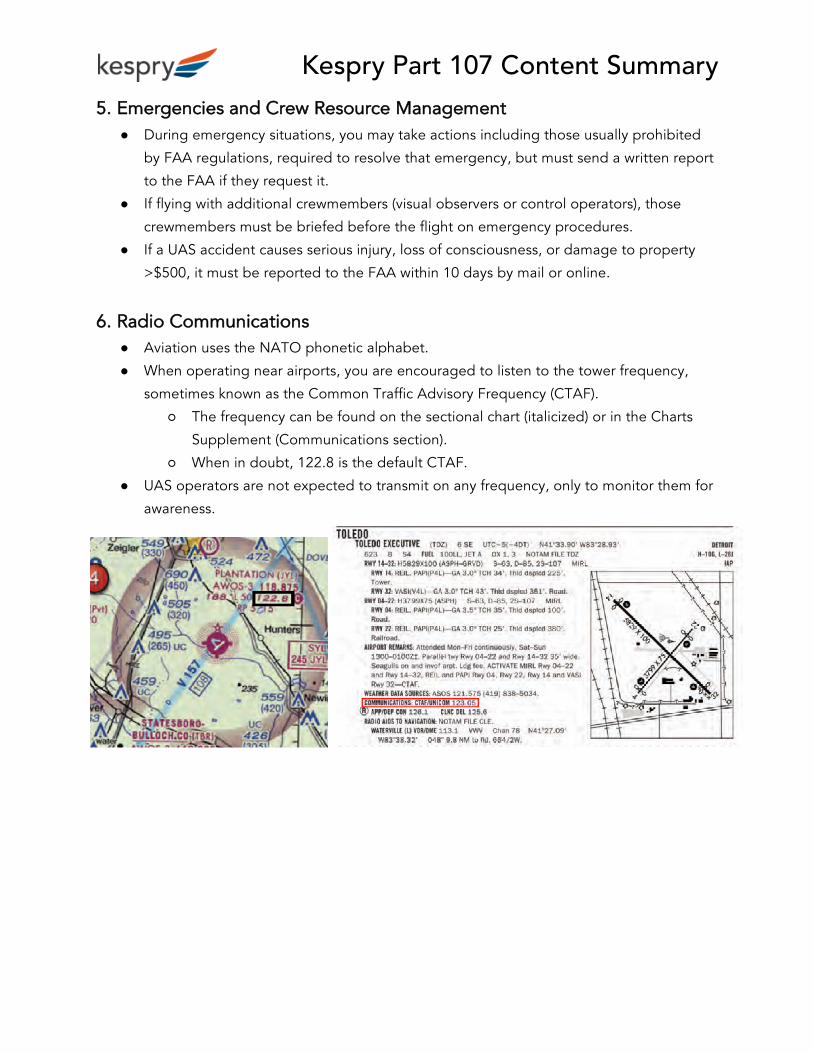
● When operating near airports, you are encouraged to listen to the tower frequency,
sometimes known as the Common Traffic Advisory Frequency (CTAF).
○ The frequency can be found on the sectional chart (italicized) or in the Charts
Supplement (Communications section).
○ When in doubt, 122.8 is the default CTAF.
● UAS operators are not expected to transmit on any frequency, only to monitor them for
awareness.

Kespry Part 107 Content Summary 7. Aircraft Performance
Density Altitude
● What the FAA Wants You To Know: High density altitude conditions reduce the
performance of sUAS. High density altitude occurs at high elevation, high temperature,
and high humidity.
● Layman’s Terms: Imagine you’re going for a walk at sea level, on a moderate
temperature day with low humidity - sounds easy enough. Now imagine trying that
same walk on the top of a mountain, on a hot and humid day - much harder! Similarly, a
drone works harder if the air is thin, hot, or humid.
● The Science: High elevation, warm temperatures, and humidity all reduce the density of
the air. Propellers generate lift by pushing against air molecules, like a swimmer
pushing off a wall. Low air density (and therefore high density altitude) means fewer air
molecules are available for the propeller to push against.
● Summary: Performance is decreased by increased temperature, increased humidity, or
higher altitude.
8. Decision Making, Crew Performance, and Judgment ● There are five key hazardous attitudes - be aware of and avoid these!
○ Anti-authority - “Don’t tell me how to do it”
○ Impulsivity - “Get it done quickly”
○ Invulnerability - “Problems won’t happen to me”
○ Macho - “I’ll prove I can do this”
○ Resignation - “It’s going to happen anyway”
● Safety checklist: Think “IMSAFE”
○ Illness: Am I sick in a way that will affect my performance?
○ Medication: Am I taking any medications that affect my mental or physical
capabilities?
○ Stress: Are there external stresses that will affect my performance?
○ Alcohol: BAC must be < 0.04%, “8 hours from bottle to throttle”
○ Fatigue: Am I tired or not adequately rested?
○ Emotional: Am I upset or distracted?

Kespry Part 107 Content Summary 9. Airport Operations
Airport Basics
● Airports can be towered or untowered. A civil airport is open to the general public, a
military airport is federally controlled, and private airports are restricted.
● Airport information is available in sectional charts, Chart Supplements, Notices to
Airmen (NOTAMs), and Automated Terminal Information Services (ATIS).
Air Traffic Pattern
● Runways are numbered with respect to magnetic north. Since a runway can be used in
either direction, each end of the runway will have a different number. In the diagram
above, the plane is using runway 12, which is 120° from magnetic north. The opposite
direction would be runway 30, 300° from magnetic north.
● The direction of the wind determines which runway direction is being used. Planes land
into the wind.
● A traffic pattern consists of 5 legs: upwind, crosswind, downwind, base, and final.
● All turns in a traffic pattern will be to the left or right. “Midfield” means the plane is
near the center of the runway.
● The blue plane in the diagram is “midfield left downwind for runway 12.” This means
the plane is approximately at the middle of the runway, making left turns, and on the
downwind leg of the pattern to land on runway 12.
True and Magnetic North
● True north is the north pole of Earth, 90° N latitude from the Equator.
● Compasses point at magnetic north, which differs slightly from the north pole. Magnetic
north is located in northern Canada.
● Variation is the difference between true north and magnetic north.

Kespry Part 107 Content Summary 10. Maintenance and Pre-flight Inspections
● Always conduct scheduled maintenance according to the manufacturer’s schedule (if
available) or best practices (if not).
● Always conduct a preflight inspection, and don’t fly until any issues found are fixed.
● Assess operating environment before flying (weather, airspace, people, hazards).
● Have a contingency site in mind in case you are not able to land where planned.
● Have a programmed link loss plan in case of loss of contact.
● Keep written or electronic records of operations and maintenance.
● Practice lithium ion battery safety, by preventing short circuits or physical damage to
the batteries. Do not use damaged batteries.